Detection of pollutant sources in the atmosphere with LidarlDial techniques: results of an experimental campaign in the south of Italy
, , ·2 l' 2 L 2 C p ' ·2 d P G d"
M. Gelfusa', A. Malizia', S. Parracino , M. Richetta , C. Belleccl ,E. Avo 10 , L. De eo , . ernmeZZl an . au 10 I Department of Industrial Engineering, University of Rome "Tor Vergata ", Via del Politeenieo 1 (00133) Roma, Italy
2 CRATI serl C/O UNICAL, 87037 Rende (CS)
Corresponding author: [email protected]
Abstract
In the last years, surveying large regions of the atmosphere in an automatic way, for early detection of pollutant sources in urban and industrial areas, has become a strategic objective of various public health organizations. The Lidar/Dial technique has become a well-established laser remote sensing method for atmosphere monitoring. It is often used to probe almost any level of the atmosphere and to acquire information necessary to validate theoretical models about different topics of atmospheric physics. It can also be deployed for environment surveying by monitoring particles, aerosols and molecules. For these reasons, an experimental campaign for evaluating the performances of a Lidar/Dial system in detecting pollutants (particulate and/or chemical compounds) has been carried out in an industrial area in the south of Italy. In this work, a homemade Lidar/Dial system (developed and built by the authors) and the results of the experimental campaign will be presented and discussed.
Keywords-Lidar; Dial; pollutants; water vapour
I. INTRODUCTION
In the year 2006 the humans living in urban areas have reached 50% of the entire world population and it is estimated that by 2050 more than 75% of humanity will be living in cities [1]. These areas, characterized by an high density of people, are particularly vulnerable to the increasing of pollution. Monitoring the quality of the atmosphere in such urban areas is therefore particularly relevant and is one of the key safety aspect of the new millennium . Lidar and Dial techniques are two examples of laser remote sensing methodologies which allow the exploration of the atmosphere [2, 3]. Traditionally they have been used to acquire information necessary to create or validate several models about different topics of atmospheric physics. On the other hand, if properly automated, they have the potential of being deployed in environmental surveying to monitor particulate and gas.
Most atmospheric pollutants are in a gaseous state with concentrations in the range between 0.01 and 10 ppm for molecules and between 0.01 and 10 ppb for metal vapours. Generally, in order to detect such substances and evaluate quantitatively their concentrations, fixed monitoring stations are employed. These stations implement different measurement techniques with integration times varying from
one minute to a few hours. They can typically evaluate the concentration of the substance, for which the system has been calibrated, only in a very limited area close to the detector. So, to cover large areas, these fixed monitoring stations have to be deployed in high numbers. In addition to the practical difficulties and the economic implications, it is to be emphasized that no sound methodology exists to determine the optimal number of measurement points and their localization. These are the reasons that motivate the development of a sensitive and fast method with the capability of measuring concentrations of atmospheric gaseous pollutants over wide areas. With the development of reliable lasers, emitting in the appropriate range of wavelengths (see later), Lidar and Dial system have become suitable and competitive techniques to face the needs described above [4].
These techniques are successfully used to measure stratospheric parameters in order to obtain experimental data to benchmark various atmospheric models. Other authors are using the Lidar technique in the field of environmental monitoring. Most of these applications work in the UV or visible region [5]. On the other hand, it is worth trying to extend the range of operation to the infrared spectral region, where there are many molecular absorption bands. Indeed, the vast majority of the substances to be detected (SOx, ammonia, ozone etc.) emit and absorb in the spectral range between 9 and 11 /lm. Furthermore a wide atmospheric spectral window is located around the wavelength of 10/lm. This characteristic of the atmosphere allows working without significant attenuation by the main components of the atmosphere (C02 , H20). this is especially true in the low troposphere, where more strict should be the monitoring of the pollution levels. Taking into account all these aspects, it has been decided to develop an integrated monitoring system using a Lidar-Dial station combining the properties of a Nd:Y AG Lidar and a CO2 Dial. The main operational approach envisages the continuous monitoring of the area to be surveyed with the Nd:Y AG laser in order to evaluate any aerosol variation. When a significant backscattered signal is detected the dial system is activated with the purpose of determining whether the increase of the aerosol level is associated to an increase in water vapour. This step is meant at determining whether the event causing the backscattering signal can be imputable to a vegetable fire (since industrial areas in Italy can be located in or close to green areas). Once the hypothesis of vegetable fires has been discarded, the exact concentration of pollutants is to be determined with the differential method based on the CO2 laser system [6]. This approach has been tested, up to the
detection of water vapour , in an extensive experimental campaign which has been carried out in Calabria , in the south of Italy.
With regard to the structure of the paper , in section 2, the systems used to obtain the measurements in the field is described. The results of the experimental campaign are reported in section 3. A final discussion is the subject of the last section of the paper.
II. DESCRIPTION OF THE LIDAR-DIAL STATION AND THE EXPERIMENTAL CAMPAIGN
A ground-based Dial station has been built and continuously upgraded at the CRA TI s.c.r.l. c/o University of Calabria
[7-10]. A similar set-up has been improved and installed on a mobile station at the University of Rome - "Tor Vergata". The physical and constructive parameters of this mobile station , used to obtain the results described in this paper , are reported in Table 1 and 2 [11, 12].
Transmitter TEA CO2 laser
Output power 109W
Beam O.77mrad
divergence
Spectral range 9 + 11!lill
A. Receiver
Primary ROC 2400mm
Primary diameter 40 0mm ZnSe lens focal
100mm length
Total Focal 576.6mm length
F.O.V. 0.88 mrad
Detector type HgCdTe Detector
3. 38. 1010 cmHzl/2/W sensitivity D*
Detector size Imm2 Table 1. Parameters of CO2 Dial system [13].
Transmitter:
Laser
Energy pulse at 106 4 nm Pulse time width Divergence angle Pulse Frequency
Receiver:
Telescope type Nominal focal length Primary mirror diameter
Detector Q-switch Nd:Yag 3 6 0mJ 5 ns 0,5 mrad 10 Hz Newtonian 103 0 mm 210mm PhotomultiQlier (PMT ) Photocathode sensibility Response time 72 mA/W 3 0 ns
Table 2. Parameters of Nd: Yag Lidar system.
Table 1 sununarizes the main characteristics of the CO2 laser
and table 2 is an overview of the Nd:Yag laser. The Dial laser is a homemade TE (Transversal-Excited ) CO2 source. The laser is tunable over about 6 0 laser lines in the spectral range between 9 and 11 11m. The telescope is based on the Newtonian configuration. The primary mirror has a diameter of 400 mm and the system presents a total focal length of 57 6. 6 mm. The Lidar measurements are performed with a commercial Nd:Yag laser; the main characteristics of the whole system developed are reported in table 2.
The two apparatuses are installed on a mobile system and therefore constitute a fully mobile station , which can be used for in field campaigns in any location.
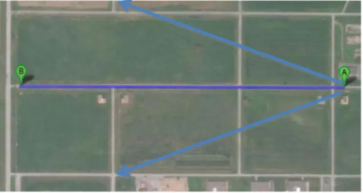
The experimental campaigns taken place in the industrial area of Lamezia Terme , in the Calabria region in the south of Italy (see figure 1). The dial laser has been tuned on the wavelengths 10R 20 and 10R 18 , corresponding to the absorbing and non-absorbing wavelengths of the water molecule [14- 17 ]. The wavelength 106 4 nm is used for the lidar system. A controlled fue , generated by the combustion of a known quantity of vegetables , has been lighted at a distance of about 5 00 m from the mobile station. An effort has been made to keep the quantity of smoke constant by periodically adding a suitable amount of vegetable material.
The backscattered signals , in the presence of fue , have been acquired for 20 different directions in a field of view of 45 degrees (see figure 1). The signals at both wavelengths have been averaged over 100 individual laser pulses for each direction.
Figure 1 - Map of the site of the experimental campaign. The blue arrows indicate the region covered by the angular scan of the system.
The entire apparatus is controlled by a software package , written in Labview and Matlab , explicitly developed for this application. The laser activation and the wavelength selection , together with the rotation of the telescope and data acquisition , is controlled by a Labview series of routines. The signal
processing algorithms and the visualization of the results have been implemented using Matlab. The signal processing routines calculate the distance of the fire from the station and also show the fire topographic coordinates (essential for the coordination of timely remedial action).
III. SIMULTANEOUS PARTICULATE AND WATER V APOUR MEASUREMENTS
In the Dial method, Lidar measurements are performed at two wavelengths to deduce the concentration of a trace gas of interest. By properly selecting the Lidar operating wavelengths, it is possible to minimize the effect of unwanted trace gas on the atmospheric transmission. The two wavelengths of the Dial system are chosen such that at the first wavelength (denoted by the subscript on) the gas of interest absorbs strongly (on-absorption band) and at the second wavelengths (denoted by the subscript oft) the gas absorb weakly (off-absorption band).
The concentration of water vapour, in the atmosphere, is highly variable (as low as few millibars and as high as few tens of millibars). A significant variation of water vapour is also a typical emission in the early phase of a forest fire. For the calculation of this concentration, the chosen on and off lines are, respectively, 1OR20 and lOR18 in the branch at 1O!ill1 . The 10R20 corresponds to 1O.591!ill1 and the lOR18 to 10.571 11m. At these wavelengths the difference in the absorption coefficients of the water molecule (L1(J' ) is equal to 7.7 .10-4
cm
-Iatm -I and the value of attenuation coefficient(a) is 0.05km-1 [18]. X 10-3 10�--�----�----�--�----�----�--� 8 6 2 oPeak due to backscatleing from smoke plume
�L-__ � ____ � ____ � __ � ____ � ____ � __ �
o 100 200 300 400
Range(m) 500 600 700
Figure 2
-
Backscattered Lidar signal in presence of smoke plume.The first warning measurements are performed by first scanning the region to be surveyed with the 10R18 non absorption line. When one or more peaks are detected in the
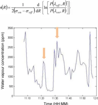
backscattered signal (see figure 2), a measurement is taken in the same direction using the second absorption line 10R20. The backscattered signal detected at this second wavelength (see figure 3 ) can then be used to determine the water concentration. Assuming that the atmosphere is homogeneous along the path length, the path average concentration of the absorption molecule n can be calculated by [18]:
where the index on or off indicate the value referred to the absorption band or to detuned wavelength, n
{
R)
is the concentration as a function of the range, P is the power received by the detector, (J' the differential absorption crosssection, f3 the backscattered coefficient and ko the total atmospheric extinction exclusive of the quantity relating to the absorption due to the substance that is being studied.
Assuming that the backscattered coefficients and the total atmospheric extinction value are almost identical at the two wavelengths, the equation 1 can be re-written as:
3500 E a. 3000 S c 0 2500
�
C Q) 2000 u c 0 u :s 1500 0 a. ro 1000 > Qj ro S 500 0 11:10 11:20 11:30 11:40 11:50 12:00 Time (HH:MM)Figure 3
-
Dial signal detected in presence of fire: water vapour profile. The two peaks are quite small because a minimum amount of vegetable material has been burned.V. CONCLUSIONS
Using the two methodologies, Lidar and Dial, it is possible to evaluate the presence of particulate with the first and recognise its composition with the second, discriminating between industrial pollutant sources and forest fires. Indeed the advances in CO2 laser technology permit to determine the water concentration, allowing to detect and\or exclude the presence of vegetable fires (depending on the application). The volume backscattering coefficients of atmospheric aerosol
for two wavelengths (10R20 and lOR18) in a dial methodology were previously measured with in cell tests [19]. As shown in the previous section, this information can be used to determine changes in the water concentration with respect to the background humidity level of the atmosphere. The fIrst experimental results indicate that the sensitivity of the Dial measurements can be quite good. Therefore the proposed method is expected to have the capability to detect even the fIrst phases of vegetable fIres and reduce the false alarms. Moreover the same laser technology can be used to determine the concentrations of pollutants generated by industrial activities: SOx, ammonia, ozone etc. A three stages approach for the surveying of large areas has been proposed: 1) detection of backscattered radiation with Lidar measurements, 2) the determination whether a vegetable fIre is present searching for water vapour and 3) the determination of the concentration of candidate pollutants with the Dial technique. The fIrst two steps have been successfully tested in the fIeld. A more comprehensive campaign, to validate also the third step, is being organised at the moment and is expected to take place immediately after obtaining the required authorisations for the emission in the atmosphere of small amounts of pollutants.
ACKNOWLEDGMENT
This work was funded by National Operational Programme for Research and Competitiveness 2007-2013 under grant SNIFF (Sensor Network Infrastructure For Factors) PON01_02422.
REFERENCES
[1] G. Fiocco and L. D. Smullin, Nature, 199, 1275 (1963). [2] R. M. Schotland, Errors in the lidar measurements of atmospheric gases by differential absorption, J. Appl. Meteor., 13, 71-77 (1974).
[3] F. Andreucci, M. Arbolino, A study on forest fIre automatic detection system,2 - smoke plume detection performance, 11 Nuovo Cimento, 16, 1, 51 (1993).
[4] c. Bellecci, M. Francucci, P. Gaudio, M. Gelfusa, S. Martellucci, M. Richetta, Early detection of small forest fue by Dial technique, SPIE Europe International Symposium on Remote Sensing, 19-22 September 2005 Bruges, Belgium, vol.
5976-14.
[5] A. Utkin, A. Fernandes, L. Costa, R. Vilar, F. Simoes, Detection of small forest fue by lidar, Appl. Phys B Lasers Opt, 74, 1, 77-83 (2002).
[6] A. Utkin, A. Fernandes, R. Vilar, A. Lavrov, Forest fue detection by means of Iidar, Forest fue research and wildland safety. Proceedings 0/ the I V International Conference on Forest Fire Research, Rotterdam: Millpress, 58 (2002). [7] C. Bellecci, G. Caputi, F. De Donato, P. Gaudio, M. Valentini, CO2 Dial for monitoring atmospheric pollutants at the University of Calabria, 11 Nuovo Cimento, 18, 5, 463-472 (1995).
[8] C. Bellecci, M. Francucci, P. Gaudio, M. Gelfusa, S. Martellucci, M. Richetta, T. Lo Feudo, Appl. Phys. B 87, 373 (2007).
[9] C. Bellecci, L. De Leo, P. Gaudio, M. Gelfusa, T. Lo Feudo, S. Martellucci, M. Richetta, Opt. & Laser Technol. 41, 374 - 379, (2009).
[10] c. Bellecci, S. Martellucci, P. Aversa, G. Caputi, F. De Donato, P. Gaudio, M. Richetta, R. Zoccali, Water vapor and ozone profIles made with TEA CO2 dial system, Romanian Journal o/Optoelectronics, 6, 4, 23-28 (1998).
[11] c. Bellecci, L. Casella, S. Federico, P. Gaudio, T. Lo Feudo, S. Martellucci, M. Richetta and P.Vetro, Evolution study of a water vapor plume using a mobile CO2 dial system, EUROPTO European Symposium on Remote Sensing, 17-21 September 2001 Tolose, France, vol. 4539, 180-190.
[12] C. Bellecci, G. D' Aquila, S. Gabriele, P. Gaudio, S. Martellucci, G. Ribecco, M. Rich etta, Comparison of columnar water vapor measurements using the CO2 DIAL method and gps data analysis, EUROPTO European Symposium on Remote Sensing, 8 September 2003 Barcellona, Spain, vol. 5232, 521-527.
[13] P.Gaudio, M. Gelfusa, A. Malizia, M. Richetta, C.SerafIni, P. Ventura, C. Bellecci, L.De Leo, T.Lo Feudo, A. Murari, New frontiers of Forest Fire Protection : A portable Laser System (FtED), WSEAS TRANSACTIONS ON ENVIRONMENT AND DEVELOPMENT, vol. 9; p. 195-205, (2013)
[14] P. Gaudio, M. Gelfusa, A. Malizia, M. Richetta, A. Antonucci, P. Ventura, A. Murari, J. Vega, Design and development of a compact Lidar/Dial system for aerial surveillance of urban areas, SPIE Conference, vol. 8894, (2013)
[15] P Gaudio, M Gelfusa, I Lupelli, A. Malizia., A Moretti, M Richetta, C SerafIni, C Bellecci, First open fIeld measurements with a portable C02 lidarl dial system for early forest fues detection, SPIE Conference, vol. 8182, (2011) [16] c. Bellecci, P. Gaudio, M. Gelfusa, A. Malizia, M. Richetta, C. SerafIni, P. Ventura, Planetary boundary layer (PBL) monitoring by means of two laser radar systems: experimental results and comparison, SPIE Conference vol. 7832, (2010)
[17] C. Bellecci and F. De Donato, Effect of the differential geometric form factor on differential absorption measurements with topographical target, Appl. Opt., 38, 5212-5217 (1999). [18] N. Menyuk, D. K. Killinger, E. DeFeo, Laser remote sensing of hydrazine, MMH and UDMH using a differential absorption CO2 Iidar, Appl. Optics, 21, 12, 2275 (1982). [19] c. Bellecci, P. Gaudio, M. Gelfusa, T. Lo Feudo, A. Murari, M. Richetta, L. De Leo, In-cell measurements of smoke backscattering coeffIcients using a C02 laser system for application to Ii dar-dial forest fue detection, Optical Engineering, 49 (12), 124302 (2010).