e-ISSN 2239-4303, DOI 10.2423/i22394303v10n2p131 Open access article licensed under CC-BY-NC-ND CASPUR-CIBER Publishing, http://www.sciresit.it
R
E
_S
TART FROM PUBLIC SPACES
:
NEW PERSPECTIVES FOR THE HISTORIC
CENTERS OF
T
REIA IN THE
M
ARCHE
R
EGION
Enrica Petrucci,* Diana Lapucci*, Noemi Lapucci*, Lucia Barchetta* *University of Camerino, School of Architecture and Design – Ascoli Piceno, Italy.
Abstract
The tragic seismic events developed in the inland areas of the Marche Region, have brought out, more clearly, phenomena that were already underway for some decades: depopulation and abandonment, economic decline and consequent construction degradation. In the case of some urban settlement within the seismic zone, we witness a scenario of almost total devastation, which requires not only a reconstruction but a real new foundation. For the re-foundation of Apennine historic centers devastated by the earthquake, it is possible to assume new interpretative paradigms, starting from the public spaces, that are space of connection and aggregation. It is analyzed the main square in the historic center of Treia, a small nucleus in the inland area of the Marche Region, to verify a project strategy, which focuses on that public space.
Keywords
Public space, Earthquake, Restart 1. Introduction
The tragic seismic events developed in the inland areas of the Marche Region, have brought out, more clearly, phenomena that were already underway for some decades: depopulation and abandonment, economic decline and consequent constructive degradation, both in the production of new architectures and in the restoration of ancient building. In the case of some urban settlement within the seismic area, we witness a scenario of almost total devastation, which requires not only a reconstruction but a real new foundation.
During the history, the design of urban spaces has always been set on exact rules: the settlement choices were to not generic reasons but to the local context, including the abundance of resources necessary for survival, such as water, fertile soils, suitable building materials, the stability of the soils and absence of natural risks. “City founders”, especially in roman times, were experts in various disciplines; they knew the territory and its best resources in detail. It was necessary to impose a pre-established order so that the new city foundation could meet specific objectives; this order allowed constant control of the space, in particular the public space (Pellegrini, 2005).
The socially and symbolically stronger space was represented by the square, around which
community life developed, linked by strong references to the material and immaterial traditions. For centuries this balance has remained unchanged, although modifying itself according to new needs, it has demonstrated how it was possible to build a local identity and at the same time has activated a resilient capacity of the whole community.
Today, after the disastrous seismic events of 2016-2017, many historic Apennine centers have suffered considerable damages, so much so as to have to face a new real re-foundation (Fabietti, Giannino, 2013). In these cases, it is necessary to consider new interpretative paradigms, starting from the connection/aggregation spaces. The case of the main square in the historic center of Treia (a small town in the Marche Region) is analyzed, in order to identify a new design strategy.
The project aims at the recovery and conservation of buildings damaged by the 2016 seismic events; It involves the reorganization of the square in strengthening its role as a cultural hub of national importance. It is necessary to consider new strategies for a gradual process of re-generation and punctual adaptation of some significant public spaces, to involve citizens and attract new development instances in the inland areas of the Marche Region. The case study highlights the importance of urban spaces such as
historic squares. For this reason, the central square “Piazza della Repubblica” in Treia is used as an example; around this urban space, a series of cultural functions are confirmed and renewed, according to a new resilient strategy, after the 2016-2017 earthquake, that made unusable many buildings in the historic center of the city.
2. The square as a public space for the community
An essential city component, the public space is both a space of representation, a space of expression and a functional element of the urban structure (Gisotti, 2016). The evolution of our society has made it a space of confrontation between public and private, vehicular and pedestrian traffic, a place of concentration of new powers and new functions (Emiliani, 1995). The organization of public spaces provides a historical legacy; the most important events took place in the city and therefore have a symbolic value that must be preserved. Historically, the square can be defined as a public space of significant architectural and urban quality, a convergence center or a gravity center of a territory (Aprile, 2015). The Italian historical squares represent the privileged places for the study of the urban development of a specific centre, not only from the urbanistic point of view but also from the economic, social, functional and ritual ones (Nencini, 2012). The central square or the squares system that represents the heart of the city constitutes the representation of the centrality presence of public institutions, civil and religious, because it is delimited by the main city monuments. Therefore, from the historical, scientific and cultural point of view, the squares in the West urban culture constitute the formal space of the community, the nucleus where the intersection of civil history, cultural movements, artistic trends, material culture, collective imagination, symbolic projections, consolidated rituals, popular traditions and behavioural habits is realized1. For all these reasons, the square is one
of the focal elements within the historic settlements. In the European urban landscape, the Italian squares are a passage of richness and
1 In the city the square represents one of the most important elements, both in function and in meaning. The shape, location, function and aesthetic expression of the square have historically followed the urban development of the city. In all historical periods, the square has been the centre of reference for the community.
complexity, a cultural model of value, from which study of Camillo Sitte, at the end of the last century, built that theory of civic and urban art (Sitte 1953). The square has had and still has different functions and meanings. On one side is the architectural delimitation of the space, and on the other side, the administrative, juridical, religious, hygienic regulations, etc. that circumscribe the space with political demonstrations, markets, fairs and festivals. This physical boundary coincides with what happens in the square (Prato, 2009).
The Greek agorà was the square in which the people agreed to contract business, to participate in public assemblies, to talk and, again, the place of demonstrations and performances (Guidoni 2006, 24-26)2. Since the Middle Ages, the square has
become the site of processions and religious representations. The square is the symbol of the Italian city and is linked to the development of our urban history, up to the 1900s (Romano, 2015).
Precisely in the century of the great social transformations and of the highest economic growth of the country has been lacking the idea and the structure of the square as a place for the “ordering” of urban design, with a notable fall in designing and reproducing urban spaces dedicated to socialization (Rykwert, 2002).
The poor interest, that has been devoted to this subject since the post-war period, seems more related to a lack of projects than to a decline in needs. However, the need and the very idea of the “square” must not lose its meaning in the area of the historic city and for this reason it is considered important to develop new prospects for use.
3. Analysis of a case‐study: Treia in history
In this research, the historical center of Treia, the ancient city of Mondavio, is taken as a reference context. After first being founded further downstream, at the beginning of the 10th century, the inhabitants of the Roman city, to escape repeated looting, identified a safer place on the hills and built the new village that took the name of Montecchio, from monticulum, small mountain (Grassi-Coluzzi 1905).
2 It is obviously impossible to analyse the tens of thousands of historic Italian squares or make them fit into a scale of values, or into typological categories; instead it is useful to highlight the possibilities of historical-urban reading offered by the squares and the essential criterion of mutual comparison even if each of them represents an individuality and not a typological abstraction.
In the 13th century, Montecchio adopted a defense system that comprised of a mighty wall and expansion to include three castles built on three hills, Onglavina, Elce and Cassero. In 1239 it was besieged by the troops of Enzo, the natural son of Frederick II, and in 1263 by those of Corrado d’Antiochia, an imperial commander who was captured by the Treies. In Constitutions Egidiane (1357), Monticulum is in the list of civitates mediocres of the Marca Anconitana. In this period, it passed to the lordship of the Da Varano of Camerino and then to Francesco Sforza, to be placed in 1447, under the control of Alfonso of Aragon; later it was ceded by Julius II to Cardinal Cesi, who followed the fortunes of the Papal States. In 1790, Pope Pius VI restored the ancient name of Treia to the area, elevating it to the rank of city (Meriggi 1983, 277-280).
The territory of the municipality is of 93.08 sq. km., with altimetric extremes of 700 m and 100 m; it is made up of calcareous slopes of the Mesozoic era, of Miocene sandstone hills and of clayey plains connected to the Quaternary floods of Potenza: the agricultural area is about 8784 hectares and is intensively cultivated with wheat, maize, vines, forage and mulberries; cattle breeding is noteworthy.
The resident population, which was estimated at around 10,000 inhabitants at the end of the 18th century, resulted in 1860 of 10,500. Currently there are 9,262 inhabitants. Although the decline in population is not particularly significant compared to other inland areas in the Marche Region, there are numerous unusable buildings due to the 2016-2017 seismic events.
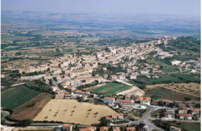
Fig. 2: The center of Treia: it is possible to perceive the
insertion of the historical nucleus within an interesting territory between the seacoast and the Apennine offshoots.
The historic center of Treia is located on a long and narrow sandstone ridge, from which the entire valley of the Potenza river is visible up to the Adriatic Sea. These scenic views find an observation point in the current Piazza della Repubblica, once named San Niccolò, where the most important city events have been held since ancient times. A stone balustrade allows you to view the interesting valley landscape that surrounds the historic center of Treia, opening the square to an unusual natural setting.
On the other three sides of the square there are important historical buildings, transformed in different eras, standardizing the facades with the advancement of the buildings for the construction of a loggia that acts as a filter for the distance of the open space.
Fig. 3: State Archive of Macerata. Fondo Catasti Storici:
Catasto Pio-Gregoriano, 1820 A.D. To the letter T of the
Brogliardo, the square named S. Niccolò.
Fig. 1: Municipal Archive of Treia, historical cartography of the mid-eighteenth century
In 1784, this side of the square was reconfigured with the arrangement of the balcony on which stands the monument to Pius VI, works of the architect Andrea Vici, an important figure of the Vanvitelli school, in the Marche (Polichetti 2009). To the north is the Georgica Academy building, designed by Giuseppe Valadier, to the west the Palazzo Comunale (XVI-XVII century) which also houses the collections of the Civic Museum.
The south fifth of the square is occupied by the façade of the Church of Saint Filippo Neri, with arcaded wings. The temple, dating back to 1766-1773, was built according to a design by the Lombard architect Carlo Augustoni, while the facade was designed by the architect Giovanni Antinori. The church began to be officiated on 26 May 1778, the day of the feast of Saint Filippo Neri. All the buildings facing the square are unusable due to the earthquake and must be restored, taking this as an opportunity to define new strategies for the reuse. These strategies could allow a new use compatible with the characteristics of the buildings to be joined with new spaces specially designed to host new functions.
Fig. 5: The Piazza della Repubblica of Treia: in the
foreground the building that houses the ancient Georgica Academy and on the left the municipal building.
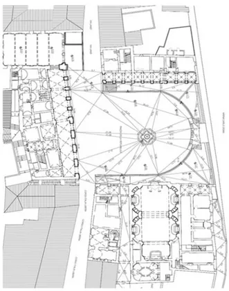
Fig. 6: Geometric survey of the Piazza della Repubblica.
Below the panoramic square rises the wall of the “Didimi” arena, inaugurated in 1818, site of the historical re-enactment of the “Disfida del Bracciale”.
Fig. 7: Historical photo showing the wall of the Didimi arena,
inaugurated in 1818, site of the historical re-enactment of “Disfida del Bracciale”.
It is a historical re-enactment that dates back to the early nineteenth century, a century of great social and political changes for the Marche region. The bracelet game has ancient roots even if its greatest development took place in the Renaissance period when, favored by princes and lords, it reached such high numbers of viewers and fame that it aroused great popular it enthusiasm
Fig. 4: The view from the Piazza della Repubblica of Treia towards the surrounding landscape.
and constituted a subject for compositions by writers and poets (Cass Sunstein, 2003).
The game was played in special arenas, called “spheristerio”, made especially in the eighteenth and nineteenth centuries in many large and small cities of northern-central Italy. These arenas had specific characteristics: first of all they needed a flat and well-beaten ground, with a bit of space around for the public and, above all, it was essential to have a side support wall about twenty meters high, like the one that can be seen in Treia.
4. Resilience capacity after the seismic events and cultural potential of Treia
The tragic seismic events that hit the inland areas of the Marche Region highlighted, with great emphasis, phenomena already underway for several decades: depopulation and abandonment, economic decline and consequent deterioration of construction in both new architecture and ancient buildings. In the case of some urban settlements within the seismic area, we are witnessing a scenario of devastation that requires not only reconstruction, but a truly new refoundation based on resilience just as humans are able to pass through complex, dramatic or unpleasant events without being weakened and turning them into an advantage3. Being resilient means adapting to
future changes or those already in place and having the skills to move forward and access new resources, positively addressing events and reorganizing, in a way unknown way before the catastrophic events.
The resilient community is defined as a community capable of developing actions to strengthen individual and group competence in order to face and manage the course of social and/or economic change (Castelletti, 2006). This competence consists of responding effectively to the adversities that challenge one's physical and social environment, achieving at the same time a better level of functioning than the condition prior to the critical event and being able to find a balance after the crisis situation. Promoting resilience in a community implies enhancing their knowledge, skills, values and culture, so that they can
3 The term resilience derives from the Latin resalio, iterative of salio, which means jumping, bouncing, by extension dancing. The word has been coined in physics of materials to indicate “the resistance to a dynamic break that can be determined with an impact test”. Starting from this meaning, the term is used in different disciplines. In psychological literature, the noun indicates the human capacity to face,
represent a resource in facing difficulties and adapting to different circumstances (Manyena 2006). The shift is therefore from a perspective in which the focus is on the shortcomings, on the needs and on the vulnerability of the community to a vision of the creative potentials and of the resources present in it. Special emphasis is placed on community culture (Ungar 2008). The values, norms and significant systems are factors of resilience capable of supporting awareness, a sense of community and participation in collective actions in case of critical events. It is necessary, therefore, to consider new strategies for a gradual process of regeneration and punctual adaptation of the most significant public spaces, to involve citizens and attract new development capacities, especially in those weaker areas even following seismic events, such as internal areas in the Marche Region. For this reason, the case of the city of Treia represents a significant example of a new resilient strategy (Scholl, Guglielmi 2013).
Treia, along with ten other municipalities along the course of the Potenza river, exists as a continuous system both in terms of territory and in terms of ability to represent a cross-section of the territorial and cultural resources of the Province of Macerata and the Marche Region.
Fig. 8: Illustrative diagrams of the thematic itineraries
organized in the project called “Valle del Pensare”, along the Potenza river.
overcome and come out reinforced by negative experiences. Recently, in literature there has been a tendency not to focus only on possible risk factors, but to turn attention to variables capable of supporting a development path. In this sense, the capacity for resilience can be transformed into opportunities, giving rise to a positive change.
The resulting framework unequivocally demonstrates the high suitability of the territory to integrate into territorial planning, with the construction of variable geometric partnerships, adapted to the characteristics of the different cycles of community programming. As part of the innovative project, “Valle del Pensare” some thematic itineraries have been identified to set up the villages of the Potenza valley.
The itineraries currently proposed concern some themes linked to local peculiarities, such as:
a) Trees and Horizons; b) Cross and Apse;
c) The Curtain and the Wall; d) The Walls and the Tower; e) Palaces and Noble Villas; f) History and Tradition; g) Canvas and Capital.
The sharing of objectives and participatory planning are some of the most effective elements not only for the construction of the project but,
4 The ten municipalities, located along the valley of the Potenza river, configure a continuous system both from a territorial point of view and as regards the ability to represent a cross-section of the resources that connote this area of the Marche Region. The opportunity to equip the area with a specific web portal arises from the need to create a clear and homogeneous communication system that can be used by the local population and tourists, facilitated in identifying valuable resources or specific thematic itineraries. The objectives of information, communication and promotion are
above all, also for its management and implementation over time4 (Bianchetti, 2015).
5. The project proposal
The urban analysis of the city and its territorial system constituted the first phase of the research, paying particular attention to the public space, to the relationship with the built environment and with public functions, both those existing before the seismic events, and those considered necessary for the development of the cultural sector. In particular, the Piazza della Repubblica represents the fulcrum of this type of activity, as the conservation structures of the important local collections are located in the buildings that face it. It therefore becomes necessary to initiate a synergy that allows the various buildings to be put into a system, identifying those actions aimed at guaranteeing better use, while respecting the historical and artistic characteristics.
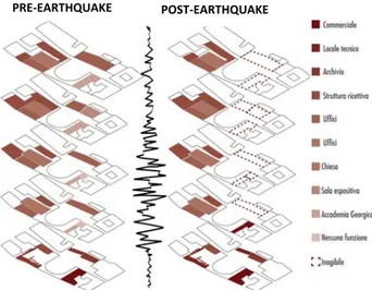
Fig. 10: Illustrative diagrams showing the functions of the
buildings located in Piazza della Repubblica, before and after the earthquake
The project proposal is aimed at the recovery and conservation of buildings damaged by the 2016 seismic events, involving also the square in an overall reorganization, strengthening its role as
naturally combined with the desire to respond to the daily needs of users, to prefer a project vision that goes beyond the simple concept of indication or plate, to be translated into an integrated, homogeneous "system", but also innovative, that is, that exploits the full potential of the most modern technologies. An added value of the project is undoubtedly constituted by the continuous interaction between the ten municipalities of the PIT called to participate in the project firsthand as profound connoisseurs of the territory and its excellences.
PRE‐EARTHQUAKE POST‐EARTHQUAKE
Fig .9: Identification of the project strategy to give
importance to the entrepreneurship in the cultural and creative sector.
a cultural pillar of national importance (as given by the presence of the Georgica Academy which has a prominence that crosses local boundaries). In particular, the project focuses on the palaces that serve as a backdrop to the square: the Palazzo del Comune which houses the museum collections, now unusable. The Accademia Palace, which houses the museum collections, now unusable.
The earthquake becomes an opportunity to rethink the functions that these buildings host, moving toward a hybrid of the pre-existing ones with new museum activities and preservation of the literary heritage. The project proposes the redevelopment of the area through an integrated program that involves the open space of the square, also enhancing a series of hypogeum environments, partly already existing and partly newly created (Romagni, Petrucci, 2018).
It is primarily in the public space, in the paths, and in the relationships between the parts, that the project takes on meaning; a connecting node between the historic center and the external area is created, a new gateway to the urban “walls”, while preserving the characteristics of the Arena Didimi where the role of the local tradition is strengthened. Through the creation of new public spaces and the reorganization of existing spaces, of free use to locals and visitors, an unprecedented urban system is planned, open to the entire city and its territorial system.
Fig.11: Design concept in which the connections between the elements of the context are highlighted: horizontal-vertical
connection + connection of the buildings to the path
The most interesting theme is represented by the construction of a sequence of covered spaces below the square and in direct visual connection with it. The hypogeum spaces are connected by a series of ramps that allow you to reach the square from the arena level, creating parking and walking opportunities, based on the needs of the users, even those with different motor and cognitive abilities. In this manner various environments are created for cultural functions (exhibitions of artistic objects, books, projections of multimedia
images, etc.) that are in direct contact with the square above, through visual telescopes that frame the main monuments, regulating the light input to obtain diffused lighting.
Fig.12: The spaces below the square that allow an "equipped" path.
In the hypogeum spaces, as happens in many historical centers of the Marche region where underground tunnels and environments are present, connections with the existing buildings are developed, for which reuse strategies have been hypothesized, in order to make the interior spaces more suitable for their functions.
The different qualities of the flooring surfaces, differentiated by materials and texture, contribute to the character of the square; the drawing of the paths guides the movements in a geometric mesh that gives order and stability to the whole.
Fig.13: The paving design with the visual telescopes that
connect the new underground and the historic city.
Even the high retaining wall of the square that forms the backdrop to the Didimi area has been renovated in order to give light to the hypogeum and to enter it, while safeguarding its function in the context of historical re-enactment. During all hours of the day the wall is an element of attraction to cultural spaces.
Fig.14: The retaining wall of the Piazza della Repubblica
which forms the backdrop for the “Didimi arena”.
It is interesting to point out that, with the new design, a reciprocal influence is generated between different elements and mutual interpenetration of ideas, attitudes and experiences to guide the general approach (Aymonino, Mosco, 2006).
In this way, a particular connection is generated between the different ancient buildings that are distributed around the square. These take on a new cultural function, in line with the general objectives of the project which reaffirm the centrality of the cultural function for the rebirth of Treia.
All the interventions are also studied to guarantee an effective consolidation of the structures, to achieve a seismic improvement that can reduce their vulnerability in case of seismic events, in an area where these phenomena are unfortunately frequent.
6. Conclusions
The Italian squares, which are often seen as a cross between nostalgic images of a lost time and unrealistically picturesque sites, still remain the spaces in which the local identity is most manifested. Cities enclose these precious spaces that remain unchanged over time. For this reason, in the case of a natural disaster, the public space may be able to generate new resilience capacities, starting a design studied according to the definition of a new urban centrality. The main elements that contribute to the formation of the public space and define its character are the relationship between built and empty, the relationship between the square and its paths, the functions installed, the presence of architectural works, the precise elements of value or historical-testimonial value and the visuals that allow a renewed perception. The research made it possible to experiment with new design ideas, aimed at actively enhancing the cultural heritage,
using different scales of intervention, from the macro-scale to the micro. First of all, the views and perspectives that can be seen from the square and which open towards the surrounding landscape (macro-landscape dimension) have been taken into consideration. The relationship with the buildings surrounding the square and with the entire urban context (macro-urban dimension) is also noted. Another important theme is represented by the creation of underground connections, with a substantial improvement in
the use of collective spaces (macro-fruition dimension). Then there are micro interventions that characterize, through new materials and new elements, the square making it more functional for parking and pedestrian travel. In conclusion, it is possible to develop a new plan for the public spaces of the historic city; this may represent, in the case of the internal areas of the Marche Region, an opportunity for rebirth for those resilient communities, which have been so badly affected by seismic events.
.
REFERENCES
Aprile, M. (2015). La dimensione locale degli spazi pubblici. Roma: EdilStampa
Aymonino, A., & Mosco, V.P. (2006). Spazi pubblici contemporanei. Architettura a volume zero. Milano: Skira Editore.
Bianchetti, C. (2015). Intimité, extimité, public. Riletture dello spazio pubblico. Territorio, 72, 7-17
Cass Sunstein, R. (2003). Republic.com. Cittadini informati o consumatori di informazioni? Bologna: Il Mulino.
Castelletti, P. (2006), La metafora della resilienza: dalla psicologia clinica alla psicologia dell’assistenza umanitaria e della cooperazione. Nuove tendenze della psicologia, 4(2), 211-233.
Emiliani, F. (1995), Processi di crescita tra protezione e rischio. In P. Di Blasio (Ed.), Contesti relazionali e
processi di sviluppo (pp. 24-30). Milano: Raffaello Cortina.
Fabietti, V., & Giannino, C. (2013). La ricostruzione dopo la catastrofe: da spazio in attesa a spazio pubblico. In V.Fabietti, C.Giannino, M. Sepe (Eds), La ricostruzione dopo una catastrofe: da spazio in attesa a spazio
pubblico (pp.2-5). Urbanistica online DOSSIER, 5, http://www.urbanisticainformazioni.it/‐005‐.html.
Gisotti, G. (2016). La fondazione delle città. Roma: Carocci Editore.
Grassi-Coluzzi, A. (1905). Annali di Montecchio ora Treja dal 1157 al 1400. Macerata: Unione Cattolica Tipografica.
Guidoni, E. (2006). Le piazze italiane dal Medioevo all’Ottocento. Progettazione, vedute, metrologia, Roma: Edizioni Kappa.
Manyena, S. B. (2006), The concept of resilience revisited. Disasters, 30(4), 433-450. Meriggi, A. (1983). Storia di Treja. Dalle origini al 1900. Tolentino: Tip. A. Pezzotti.
Nencini, D. (2012). La piazza. Significati e ragioni nell’architettura italiana. Milano: Christian Marinotti Edizioni
Pellegrini, P.C. (2005). Piazze e spazi pubblici. Architetture 1990‐2005. Milano: Federico Motta Editore. Polichetti, M. L. (Ed) (2009). Andrea Vici, Architetto e Ingegnere Idraulico. Atlante delle opere. Milano: Silvana Editoriale.
Prato, D. (2009), Giù la piazza non c’è nessuno, Macerata: Quodlibet.
Romagni, L., & Petrucci, E. (2018). Alterazioni. Osservazioni sul conflitto fra antico e nuovo. Macerata: Quodlibet.
Romano, M. (2015). La piazza europea. Venezia: Marsilio editore.
Rykwert, J. (2002). L’idea di città. Antropologia della forma urbana nel mondo antico. Milano: Adelphi. Sitte, C. (1953). L’Arte di costruire le città. Milano: Antonio Vallardi.
Scholl S., & Guglielmi M. (2013). Il potere rigenerativo dello spazio pubblico. In V.Fabietti, C.Giannino, & M. Sepe (Eds), La ricostruzione dopo una catastrofe: da spazio in attesa a spazio pubblico (pp.10-14).
Urbanistica online DOSSIER, 5, http://www.urbanisticainformazioni.it/‐005‐.html.