IT Technologies for Science Application: Using Meteorological Local Area
Model to Contrast the Hydrogeological Risks
Colombo F1,3, Castorina G1, Caccamo MT1, Insinga V2, Maiorana E2 and Magazù S1*
1Department of Mathematical and Informatics Sciences, Physical Sciences and Earth Sciences (MIFT), University of Messina, Viale F. S. D’Alcontres 31, 98166 Messina, Italy
2Consorzio Interuniversitario Scienze Fisiche Applicate (CISFA), Viale F. S. D’Alcontres 31, 98166 Messina, Italy 3Italian Air Force Meteorological Service- Comando Aeroporto- Sigonella, Italy
*Corresponding author: Salvatore Magazu, Department of Mathematical and Informatics Sciences, Physical Sciences and Earth Sciences (MIFT), University of
Messina, Viale F. S. D’Alcontres 31, 98166 Messina, Italy, Tel: 090 6765025; E-mail: [email protected]
Received date: September 19, 2017; Accepted date: September 22, 2017; Published date: September 29, 2017
Copyright: © 2017 Magazu S, et al. This is an open-access article distributed under the terms of the Creative Commons Attribution License, which permits unrestricted
use, distribution, and reproduction in any medium, provided the original author and source are credited.
Abstract
During last 20 years, Sicily has been affected by an increasing sequence of extreme weather events that have produced, besides huge damages to both environment and territory, the death of hundreds of people together with the evacuation of thousands of residents, which have permanently lost their houses. The aim of this paper is to describe the Weather Research and Forecasting Model (WRF) and to report findings obtained, through this model, in a relevant case study. On purpose a WRF Local Area Model (LAM) has been used to re-analyze the heavy rainfall occurred during the night of October 10th, 2015 in Sicily. The re-analysis of this case study, shows how a LAM, suitably configured for the complex orography of Sicily, is able to forecast this kind of extreme weather events. This study clearly shows how forecasts obtained using this kind of model can be very useful to reduce the hydrogeological impact of extreme events on the environment and on territory.
Keywords: WRF model; Hydrogeology; Heavy rain; Complex orography; Sicily; Weather forecast
Introduction
The Numerical Weather Prediction (NWP) represents one of the most complex challenges in Atmospheric Physics. The goal of knowing in advance the evolution of weather with a reasonable degree of reliability is now available thanks to the development achieved by modern computers. The parallel development of computer networks and the Internet has made available the capillary weather forecasts thanks, for example, to the availability of specific applications on multiple communication devices. A meteorological model is a schematic and simplified representation of physical reality, described through a set of equations that simulate the behaviour of the atmosphere. A particular software uses input data, executes a run using algorithms based on a coupled equation set, and expresses the output result in the form of a new set of data. In the case of meteorological forecasting, calculation algorithms consist of a set of differential equations for partial derivatives, which describe the dynamics of the atmosphere. The main nucleus of a calculation code for the solution of that differential equation system is normally formulated in FORTRAN. Specific subroutines, such as matrix processing, standard mathematical functions, and graphic sections may use other languages, usually C. The input data of the model uses the values of surface pressure, wind speed components, air temperature and humidity at different atmospheric levels (up to about 50 km in height).
The WRF Model
The Weather Research and Forecasting (WRF) model is a new generation numerical forecasting system designed for operational and operational forecasting of atmospheric phenomena.
WRF is the result of the collaboration between the National Centre for Atmospheric Research (NCAR), the National Centres for Environmental Prediction (NCEP) and the Earth's System Research Laboratory (ESRL) of the National Oceanic and Atmospheric Administration (NOAA). It is consisting of a central nucleus, called the WRF Software Framework (WSF), which consists of several assimilation and parameterization schemes for physicochemical variables, to which pre- and post-processing modules are connected. The pre-processing phase (WPS) includes three routines, Geogrid, Ungrib, and Metgrid, that sequentially handle the data that drives the model. Geogrid creates static data that includes geographic data and land use data; Ungrib assimilates the GRIB data collected by the global computing centres, while Metgrid intercepts the horizontal weather data, scaling them to the domain originally defined.
So pre-processed data is passed to other calculation routines, and specifically to the WRF-REAL software that interpolates the data in the model's spatial coordinates.
The final phase of the process is the production of output data originating from the WRF software and subsequent post-processing production.
The "core" that govern the dynamics of the WRF model are two: • Advanced Research WRF (ARW), a computational code developed by NCAR, capable of simulating different types of weather events with different spatial resolutions.
• Non-hydrostatic Mesoscale Model (NMM), manufactured by NCEP, able to operate both hydrostatic and non-hydrostatic.
Hydr
olog y: Current R
esearc
h
ISSN: 2157-7587
Hydrology Current Research
Colombo et al., Hydrol Current Res 2017, 8:4 DOI: 10.4172/2157-7587.1000284
Review Article OMICS International
Hydrol Current Res, an open access journal
Limited Area Model Optimized for Sicily
The model configuration is specifically optimized for the Sicilian territory. The GTOPO30 digital elevation model developed by USGS working at 30 arcsec resolution has been replaced by the ASTER GDEM V2 model, as a result of the collaboration established in 2011 between METI (Ministry of Economy, Trade, and Industry of Japan) and NASA, characterized by a 1 arcsec resolution.
The USGS data (Land use) at a 30 arcsec resolution were replaced by Corine Land Cover 2006 data, developed by EEA (European Environment Agency) characterized by a 3 arcsec resolution, reclassified on 24 classes of Land use [1].
The global model NCEP FNL at 0.25 degrees with a time interval resolution of 3 h, processed for the 00Z run relative to the 10 October 2015 have generated the initial and boundary conditions. Were used the RTG sea surface temperature data with a resolution of 0.083 degrees. For long-wave radiations the RRTM (Rapid Radiation Transfer Model) scheme was used [2], while for the short-wave radiations the Goddard scheme [3]. In addition, the above, were also used the schemes of Mellor-Yamada-Janjic [4] for the boundary layer and Noah land surface model [5].
The microphysical scheme utilized was the Thompson [6] a well-known double-moment scheme widely tested especially in high-resolution simulations. In the Nesting Two Way simulations for the parent-domains, the Kain Fritsch convective scheme [7] was used, while for the subdomains the resolution of convective processes was explicit.
A number of 65 vertical levels with higher resolution for the levels close to the surface and to the top of the air column using a vertical distribution with hyperbolic tangent were employed using the WRF software DOMAIN WIZARD distributed by NOAA.
The determination of the configuration with horizontal grid spacing of 10 km came out by a single-run that covered a wide area with extension from latitude 30.03 DEG to 44.35 DEG and longitude from 2.67 DEG to 25.64 DEG.
The Case Study of October 10th, 2015
The meaningful increase of the extreme meteorological events to regional, national and international scale produces more and more interest and worry in the public opinion. Phenomena like flash floods,
lightning, violent winds and severe storms have notable repercussions on the daily life because they can produce landslides, damages to buildings and to the agriculture and, in the most tragic circumstances, loss of human life. In early autumn, the Mediterranean cyclones that originate from the contrast between air masses with very different temperatures and humidity interacting with seawater high temperature (Sea Surface Temperature, SST), affect the seas surrounding Sicily. These conditions can cause extreme weather events characterized by sudden and heavy rainfalls and dangerous flash floods [8].
During the night of October 10, 2015, a severe convective storm affected the north-eastern of Sicily. In that case, the Antillo meteorological station, which is a unit of SIAS (Servizio Informativo Agrometeorologico Siciliano) weather stations network, recorded, from 00 to 09 UTC, a maximum precipitation accumulation of 182 mm [9]. The heavy rains occurred were the results of a mesoscale convective system, developed in the Ionian Sea and powered in the low atmospheric layers by the very humid Southeastern streams. Another important element that triggered the violent thunderstorm was the orographic lift induced by the barrier of Nebrodi and Peloritani Mountains, together with the one induced by Mt. Etna.
Despite the short duration, these phenomena were so powerful to produce a greater accumulation of rain of 182 mm, as recorded by Antillo weather station. This quantity of rain was sufficient to determine the Mela creek overflow and the flash flood occurred in Milazzo and Barcellona Pozzo di Gotto, both located on the Tyrrhenian coastline.
The test on the episode shows that the LAM model optimized for Sicily has given positive results that have captured perfectly both the spatial localization of precipitation and the quantities then occurring. The relevant factor to obtain good precipitation prediction has been attributed to the utilization of the Two-Way Nesting technique instead of a single-run configuration. While single-run uses as boundary conditions the Global Model data, holding a lower resolution and, in the case of FNL, three-hours of input frequency, in the Nesting approach, the subdomain with a higher resolution uses as LBC the father domain (parent domain), which has a better vertical and horizontal resolution than the Global Models conditions. In the Nesting Two Way simulation with a subdomain at 800 m. of grid spacing, the phenomena result strongly enhanced by orography, revealing a great foresight performance of the V-Shape thunderstorm that affected Messina on the night of 10 October 2015 (Figure 1).
Citation: Colombo F, Castorina G, Caccamo MT, Insinga V, Maiorana E, et al. (2017) IT Technologies for Science Application: Using Meteorological Local Area Model to Contrast the Hydrogeological Risks. Hydrol Current Res 8: 284. doi:10.4172/2157-7587.1000284
Page 2 of 4
Hydrol Current Res, an open access journal
Figure 1: Total Rain (mm) a 10 Km (on the left). Precipitation provided by LAM in Nesting two-way configuration with a horizontal grid spacing of 0.8 km (on the right).
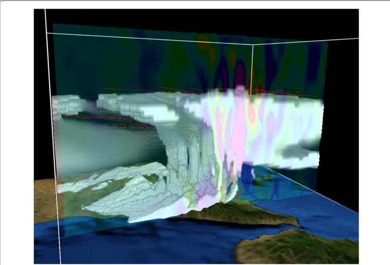
The 0.8 km resolution has also allowed to rebuild the structure of a thundercloud, as visible on Figure 2, where it is highlighted not only the morphological structure of the thunderstorm cell, but also the top
altitude reached by cumulonimbus. The image is obtained plotting the QCLOUD field of WRF by VAPOR software.
Figure 2: Structure of the thunderstorm cell at 06:00 UTC obtained plotting a Direct Volume Rendering of CLDFRA field with isosurface=1.
Citation: Colombo F, Castorina G, Caccamo MT, Insinga V, Maiorana E, et al. (2017) IT Technologies for Science Application: Using Meteorological Local Area Model to Contrast the Hydrogeological Risks. Hydrol Current Res 8: 284. doi:10.4172/2157-7587.1000284
Page 3 of 4
Hydrol Current Res, an open access journal
Conclusion
IT technologies have become indispensable tools for forecasting. In this paper we have shown findings obtained by modelling atmosphere for weather forecasting use. The stormy event of 10th October 2015 was used as a "case study" and has allowed us to compare the data collected from the weather stations network available in Sicily with the model outputs. The numerical simulations carried-out with the use of WRF-ARW model, properly set and configured for Sicily, was to find out the best compromise between the finest spatial resolution and the available calculation capacities to obtain timely the best possible forecast. The test clearly shows that the improvement of the model grid spacing, together with the use of more accurate geographic data and the land use data, more suitable for the description of the territory, are the key elements for the prediction accuracy. This is especially true for geographic areas like Sicily that are characterized by the presence of complex orographic structures.
References
1. Pineda N, Jorba O, Jorge J, Baldasano JM (2004) Using NOAA AVHRR and SPOT VGT data to estimate surface parameters: application to a mesoscale meteorological model. International Journal of Remote Sensing 25: 129-143.
2. Mlawer EJ, Taubman SJ, Brown PD, Iacono MJ, Clough SA (1997) Radiative transfer for inhomogeneous atmosphere: RRTM, a validated correlated k-model for the long-wave. J Geophys Res 102: 16663-16682. 3. Chou MD, Suarez MJ (1994) An efficient thermal infrared radiation
parameterization for use in general circulation models. Technical Report, NASA/Goddard Space Flight Center.
4. Janjic ZI (2002) Nonsingular implementation of the Mellor-Yamada level 2.5 scheme in the NCEP meso model. Technical Report 437, NOAA Science Center.
5. Chen F, Dudhia J (2001) Coupling an advanced land-surface/hydrology model with the Penn state/NCAR MM5 modeling system. Part I: model description and implementation. Mon Weather Rev 129: 569-585. 6. Thompson G, Rasmussen RM, Manning K (2004) Explicit forecasts of
winter precipitation using an improved bulk microphysics scheme, Part I: description and sensitivity analysis. Mon Weather Rev 132: 519-542. 7. Kain JS (2004) The Kain–Fritsch convective parameterization: an update.
J Appl Meteorol 43: 170-181.
8. Cassola F, Ferrari F, Mazzino A (2015) Numerical simulations of Mediterranean heavy precipitation events with the WRF model: a verification exercise using different approaches. Atmospheric Research 164-165: 210-225.
9. Caccamo MT, Castorina G, Colombo F, Insinga V, Maiorana E, et al. (2017) Weather forecast performances for complex orographic areas: Impact of different grid resolutions and of geographic data on heavy rainfall event simulations in Sicily. Atmospheric Research 198: 22-33.
Citation: Colombo F, Castorina G, Caccamo MT, Insinga V, Maiorana E, et al. (2017) IT Technologies for Science Application: Using Meteorological Local Area Model to Contrast the Hydrogeological Risks. Hydrol Current Res 8: 284. doi:10.4172/2157-7587.1000284
Page 4 of 4
Hydrol Current Res, an open access journal