CYPRIA
ΤΟΜΟΣ VII
ARCHAEOLOGIA
CYPRIA
ΤΟΜΟΣ VII
Σύνδεσμος Κυπρίων Αρχαιολόγων
Λευκωσία - Κύπρος
2018
ΕΠΙΤΡΟΠΗ ΕΚΔΟΣΗΣ Δέσποινα Πηλείδου Γιάννης Βιολάρης Χαράλαμπος Παρασκευά Ουρανία Μιχαήλ Μαρία Μιχαήλ Βασιλική Λυσάνδρου Χρυσάνθη Κούννου ΣΧΕΔΙΑΣΤΙΚΗ ΕΠΙΜΕΛΕΙΑ ΕΚΔΟΣΗΣ Λήδρας 192, 1011 Λευκωσία, Κύπρος Τηλ: 22676752 Φαξ: 22676754 [email protected] www.keramos-publishing.eu Διευθυντής Εκδόσεων: Θωμάς Κωστή ΕΚΤΥΠΩΣΗ/ΒΙΒΛΙΟΔΕΣΙΑ
[βιβλιοτεχνία]
Παπαρρηγόπουλου 6Α, Περιστέρι, Αθήνα Tηλ: +30 210 5789355 [email protected] Copyright ©2018 Σύνδεσμος Κυπρίων Αρχαιολόγων Η έκδοση εντάσσεται στη σειρά Archaeologia Cypria του Συνδέσμου Κυπρίων Αρχαιολόγων ως τόμος VII. Σύνδεσμος Κυπρίων Αρχαιολόγων Τ.Κ. 20058, Λευκωσία, 1600, Κύπρος www.aca-cy.orgISSN 0257-1951
ΕκδόσειςΚΕΡΑΜΟΣ
Κατάλογος Συγγραφέων 6
Preface 7
Edgar J. Peltenburg - In Memoriam 9
DESPINA PILIDES and CHARALAMBOS PARASKEVA
Edgar J. Peltenburg - A Comprehensive Bibliography 21
Compiled by CHARALAMBOS PARASKEVA
From Observation to Interpretation: The Data Recording and 51
Processing System Developed at Khirokitia (Cyprus, VII-VI Millennia BC)
ODILE DAUNE-LE BRUN
Khirokitia Archives (Cyprus): A Pilot Digitization and Online 59
Publishing Program of the Archives Service at the Maison Archéologie & Ethnologie, René-Ginouvès, France
ELISABETH BELLON
Little Big Data. On-going Archaeological Science-based 69
Researches at Bronze Age Erimi-Laonin tou Porakou
LUCA BOMBARDIERI, CATERINA SCIRÈ CALABRISOTTO, FRANCESCA CHELAZZI and MARIALUCIA AMADIO
Moni Valley (Cyprus): Survey, Archaeometry and 95
Landscape Archaeology, Seasons 2011-2013
OLIVA MENOZZI, EUGENIO DI VALERIO, SILVANO AGOSTINI, SONIA ANTONELLI, MARZIA TORNESE, MARCELLA GIOBBE, MARIA CRISTINA MANCINI,
SERENA TORELLO DI NINO and ANGELA CINALLI
Palaeodemographic Analysis of a Byzantine-Medieval Neighbourhood 135
in Nicosia-Palaion Demarcheion (‘Old Municipality’) 2002-2004
POPI CHRYSOSTOMOU and YIANNIS VIOLARIS
Ιστορίες Κατοίκησης από τη Λευκωσία του 14ου Αιώνα μ.Χ. 163
ΒΙΟΛΑΡΗΣ ΓΙΑΝΝΗΣ Αρχαιολογικός Λειτουργός, Τμήμα Αρχαιοτήτων, Κύπρος· Αντιπρόεδρος, Σύνδεσμος Κυπρίων Αρχαιολόγων, Κύπρος ΛΕΒΕΝΤΗΣ ΠΑΝΟΣ Αναπληρωτής Καθηγητής, Σχολή Αρχιτεκτονικής John Q. Hammons, Πανεπιστήμιο Drury, Ηνωμένες Πολιτείες Αμερικής ΠΑΡΑΣΚΕΥΑ ΧΑΡΑΛΑΜΠΟΣ Μεταδιδακτορικός Ερευνητής, Τμήμα Ιστορίας και Αρχαιολογίας, Πανεπιστήμιο Κύπρου, Κύπρος· Γραμματέας, Σύνδεσμος Κυπρίων Αρχαιολόγων, Κύπρος ΠΗΛΕΙΔΟΥ ΔΕΣΠΟΙΝΑ Έφορος Αρχαιοτήτων, Τμήμα Αρχαιοτήτων, Κύπρος· Πρόεδρος, Σύνδεσμος Κυπρίων Αρχαιολόγων, Κύπρος ΧΡΥΣΟΣΤΟΜΟΥ ΠΟΠΗ Αρχαιολογική Λειτουργός, Τμήμα Αρχαιοτήτων, Κύπρος· Ερευνητική Συνεργάτης, Σχολή Επιστημών και Μηχανικής, Πανεπιστήμιο Teesside, Ηνωμένο Βασίλειο AGOSTINI SILVANO Διευθυντής της Γεωλογικής και Παλαιοντολογι-κής Υπηρεσίας, SABAP, Υπουργείο ΠολιτιστιΠαλαιοντολογι-κής Κληρονομιάς και Τουρισμού, Ιταλία AMADIO MARIALUCIA Διδακτορική Φοιτήτρια, Σχολή Αρχαιολογίας, Γεωγραφίας και Επιστημών του Περιβάλλοντος, Πανεπιστήμιο Ρέντινγκ, Ηνωμένο Βασίλειο ANTONELLI SONIA Λέκτορας, DiSPUTer, Αρχαιολογική Μονάδα, Πα-νεπιστήμιο Κιέτι-Πεσκάρα G. D’Annunzio, Ιταλία BELLON ELISABETH Ερευνήτρια CNRS, Διευθύντρια Τμήματος Αρχεί-ων, Μονάδα Αρχαιολογίας και Εθνολογίας René-Ginouvès, Πανεπιστήμιο Παρισιού στο Nanterre, Παρίσι 1 - Πάνθεο-Σορβόννη, Γαλλία BOMBARDIERI LUCA Επίκουρος Καθηγητής, Τμήμα Ανθρωπιστικών Σπουδών, Πανεπιστήμιο Τορίνο, Ιταλία CHELAZZI FRANCESCA Ερευνητική Συνεργάτης, Τμήμα Αρχαιολογίας, Σχολή Ανθρωπιστικών Επιστημών, Πανεπιστήμιο Γλασκόβης, Ηνωμένο Βασίλειο CINALLI ANGELA Επιγραφολόγος, Μέλος της Διεθνούς Αρχαιολο-γικής Αποστολής του Πανεπιστημίου Κιέτι στην Αίγυπτο, Λιβύη και Κύπρο, Ιταλία
DAUNE-LE BRUN ODILE
Ερευνητική Συνεργάτης, Ομάδα VEPMO, Μονά-δα Αρχαιολογίας και Εθνολογίας René-Ginouvès, Πανεπιστήμιο Παρισιού στο Nanterre, Παρίσι 1 - Πάνθεο-Σορβόννη, Γαλλία
DI NINO SERENA TORELLO
Αρχαιολόγος, Μέλος της Διεθνούς Αρχαιολογι-κής Αποστολής του Πανεπιστημίου Κιέτι στην Αίγυπτο, Λιβύη και Κύπρο, Ιταλία DI VALERIO EUGENIO Διδακτορικός Φοιτητής, DiSPUTer-CAAM, Αρχαι-ολογική Μονάδα, Πανεπιστήμιο G. D’Annunzio στο Chieti-Pescara, Ιταλία GIOBBE MARCELLA Μεταπτυχιακή Φοιτήτρια-Αρχαιομέτρης, Τμήμα Αρχαιολογίας, Πανεπιστήμιο Σέφιλντ, Ηνωμένο Βασίλειο
MANCINI MARIA CRISTINA
Λέκτορας, DiSPUTer, Αρχαιολογική Μονάδα, Πα-νεπιστήμιο Κιέτι-Πεσκάρα G. D’Annunzio, Ιταλία MENOZZI OLIVA Αναπληρώτρια Καθηγήτρια, DiSPUTer-CAAM, Αρχαιολογική Μονάδα, Πανεπιστήμιο Κιέτι- Πεσκάρα G. D’Annunzio, Ιταλία
SCIRÈ CALABRISOTTO CATERINA
Ερευνητική Συνεργάτης, Τμήμα Ανθρωπιστικών Σπουδών, Πανεπιστήμιο Ca’Foscari Βενετίας, Ιταλία TORNESE MARZIA Υπότροφος-Αρχαιολόγος, DiSPUTer, Αρχαιολο-γική Μονάδα, Πανεπιστήμιο Κιέτι-Πεσκάρα G. D’Annunzio, Ιταλία
This volume is dedicated to the memory of two great benefactors of Cypriot archaeology, who in very different ways served to enhance knowledge and to preserve the heritage of Cyprus, Edgar Peltenburg and Yiannis Kleanthous. Both passed away very recently and have left the archaeology of Cyprus and their many friends and associates bereft of their vibrant presence.
Eddie first met Yiannis at Kyrenia castle in the mid-1960s when, as a PhD student at the University of Birmingham, travelled to Cyprus to study material for his thesis. Several years later, after the start of his excavations at Ayios Epiktitos-Vrysi (1969-73), Eddie’s contact with Yiannis became more frequent and began to develop into a close friendship that would last for the remainder of Eddie’s life. Their paths continued to converge after 1974 when Yiannis was forced to move to Paphos where he resumed his work with the Department of Antiquities and helped to create the Folk Art Museum at Yeroskipou (established in 1978), at the same time that Eddie began excavations at the Chalcolithic site of Lemba-Lakkous (1976). In 1981, after Yiannis had settled into a house in the village of Lemba (which he later named ‘Karmi’ after his village of birth), they would meet regularly for drinks and long discussions under the mulberry tree, surrounded by cats, in Yiannis’ magnificent garden with its fine view of the sea. Yiannis was a member of Eddie’s fieldwork team for eight seasons of excavation at Kissonerga-Mosphilia (1985-1992) and was Eddie’s koumbaros for his marriage to Diane Bolger in Paphos (2012). Eddie admired Yiannis for his magnificent and generous spirit, his amazing storytelling abilities, and his deep knowledge of Cyprus and regarded him as his best and oldest friend on the island. It would be wonderful to think that they are together again somewhere, drinking wine, laughing and
reminiscing about old times in the occupied north part of the island. It is my hope that the joint dedication of this volume to their respective memories is well within the spirit of their friendship during their lifetime and will help keep it alive in our hearts and minds.
The volume consists of seven papers. The majority are based on lectures given at the invitation of the Society of Cypriot Archaeologists, by known archaeologists and researchers on various topics of Cypriot archaeology. One of the main tasks of the current Board of the Association was to organise lectures for the public in an effort to raise awareness and interest in the archaeological heritage of the island, thus fulfilling one of its main statutory requirements. On behalf of the Board, I would like to express my gratitude to the speakers and contributors to the volume, as well as to express my sincere thanks to the Secretary, co-editor of this volume, and members of the Council for their hard work, spirit of co-operation and dedication to the causes of the Association.
Despina Pilides President Association of Cypriot Archaeologists
This project, a study of the landscape in the area of Moni, Pyrgos, and Monagroulli (Limassol-Cyprus), began in 2011 with a large team, including scholars, as well as PhD and MPhil students from different institutions.1 The research employs a suite of traditional methodologies for the study of landscape (intensive and judgmental survey, GIS mapping, location of the sites using differential-GPS, studies on typologies, distribution and statistics of pottery finds), in combination with technologies to integrate and augment the above information (remote sensing on aerial photos and high definition panchromatic satellite photos, geomorphological reconstruction of contexts, archaeometric analyses of finds and building materials, and non-invasive geophysical prospection). This paper provides the preliminary results of the project’s first three years of work.
The Project: Aims and Methodologies
(Menozzi Oliva)
Since 2011, the University of Chieti has been working in the area of the Moni River valley, a survey project aiming at the reconstruction of the ancient landscape via the application of different technologies and archaeological, geological and environmental protocols, which have been widely tested and codified by the team in international projects in Libya, Egypt and Cyprus.2 This work began after the completion of the 1 DiSPUTer, Università di Chieti G.D’Annunzio-Archaeological Unit; CAAM-Centro di Ateneo di Archeometria e Microanalisi of Chieti, for the archaeometric analysis; Museo Universitario di Scienze Naturali, for the anthropological, paleobotanical and paleo-ecological analyses; MIBACT-Ministero Italiano per i Beni e le Attività Culturali ed il Turismo: Servizio di Geologia e Paleontologia della Soprintendenza per i Beni Archeologici per l’Abruzzo, for the geological and geomorphological survey.
2 Bombardieri et al. 2009, 2010; Fossataro and Menozzi 2010; Menozzi and Fossataro 2010.
Survey, Archaeometry and Landscape
Archaeology, Seasons 2011-2013
OLIVA MENOZZI, EUGENIO DI VALERIO, SILVANO AGOSTINI,
SONIA ANTONELLI, MARZIA TORNESE, MARCELLA GIOBBE,
MARIA CRISTINA MANCINI, SERENA TORELLO DI NINO
and ANGELA CINALLI
Kouris Valley survey project, a collaborative work between the Universities of Chieti and Florence, and following a period of collaboration between the University of Chieti and a team of the CNR-ITABC of Rome, working at Pyrgos.
The vast bibliography regarding the methodologies and limits of surface survey, especially without proper controls and analyses, aided the clarification of the main goals, as well as the potential issues to be faced by our project.3 Therefore, it was considered necessary to employ a multidisciplinary and multi-methodological ap-proach, so as to avoid improper interpretations of the data.4 Furthermore, the large quantity of data produced by the application of a wide-scoped approach necessitated the production of a flexible, multilayer database. The latter is supported by a GIS system, which guarantees the precise location of each information packet, as well as the perfect integration with other geodata and analyses.5
The Moni Valley project is a regional study and is mainly based on a multidisciplinary scientific approach, involving archaeological specialists in different periods, such as geoarchaeologists, geomorphologists, paleo bota nists, topographers and archaeo-metrists, who cooperated to create a more complete view of the area both diachro-nically and synchrodiachro-nically. This multi-disciplinary work employed both traditional and instrumental surveys of the area to produce archaeological maps, and a GIS that included the main mineral and hydro-geological resources, the ancient road-network, and the distribution of ancient sites and finds.
Future limited soundings and excavations as stratigraphic tests will allow a wider and more critical interpretation of surface data. Moreover, the control of the scatter sites is also performed using different non-invasive methods and technologies, such as geo-prospection, remote sensing and photo-interpretation. For a complete interpre-tation of the finds, the project also employs archaeometric analyses of the main ce-ramic fabrics as well as a geoarchaeological survey for mapping the main sources for the pottery locally produced. Paleobotanical analysis and palaeoenvironmental inter-pretation, which are currently in progress, are completing the view of this territory. The data accumulated by the research and surveys of the various teams and the results of their analyses are converging in real time into a GIS platform which is organised on several interactive levels, allowing different views of the data and of the territory, with the possibility to change the topographic base according to research needs. 3 Ammerman 1981; Dyson 1982; Cherry 1984; Hope-Simpson 1984, 1985; Barker and Lloyd
1991; Mattingly 1991; Anderson and Mikhail 1998; Wilkinson et al. 2004. 4 Gaffney et al. 2004.
This multilayer approach is particularly important for a research involving more teams and specialists working on different fields. Moreover, it also allows the possi-bility to exchange data, views and methods with other teams working on common bases, as well as with the Department of Antiquities, which can control directly sea-son by seasea-son both the territory and the results.
The cartographic base of the project was compiled by merging different topographic and cadastral maps, high definition satellite images, geological maps, and finally alti-metric and topographic data acquired though Differential-GPS and geo-radar. In this way, all the information from digital and paper cartography can be used to bring to-gether as much information as possible, which is then organised in several layers for the GIS of the area, and is updated regularly with the data coming from field survey, soundings, geophysical survey, geomorphologic analysis and the old information from previous excavations and surveys. In this way, the GIS can be used for very different purposes, such as the location of archaeological finds and remains on the cadastral plots, as well as for a geological or environmental study of the area, or for the recon-struction of the ancient landscape in different periods. Obviously, a unified methodol-ogy, both in the field survey and in the recording of data, is extremely important for a complete view and exhaustive study of the territory. Therefore, the database, which has been developed in Microsoft Access, consists of several cross-linked data entry forms, which are then imported into the GIS project, collecting a large amount of data. The field survey is based on a combination of judgmental and intensive survey, the latter with small teams of people walking at regular distances to maintain a homoge-neous sampling strategy, currently set at 40%. However, in steep or very hilly areas, where it is difficult for people to walk in parallel lines, GPS is used to normalize the sampling strategy by recording the walked tracks and multiplying them by the num-ber of the surveyors obtaining a resulting ‘plausible’ sampling strategy for each team. Each surveyed field is recorded, both for positive and negative finds, in a field data entry form, which is then linked with further data entry forms for scatter sites, struc-tures, geomorphological units, finds records and other finds. The archaeological sites are then positioned, with the DGPS coordinates in 3D, while the last step includes the 3D modelling of a DEM (Digital Elevation Model) and a DTM (Digital Terrain Model) of the surrounding territory for a better interpretation and reconstruction of the ancient landscape, and for mapping in a proper way the possible ancient passages, road network and natural crossing points.
One of the layers of the GIS, is collecting data from the geophysical survey. The meth-odology employed for this non-invasive investigation consists of the practical appli-cation of three types of instruments, which are well known and extensively used in archaeological contexts, namely geo-radar, magnetometer/gradiometer and geo-re-sistivity detector. The choice of instrument for each plot is decided based on the ge-omorphology of the area, and in cases of particularly interesting areas or results, a second method is combined for better interpretation of the resulting anomalies attesting the probable presence of archaeological remains. In our recent seasons, we have mainly used the magnetometer/gradiometer, employing a GEM-GSM 19 Mag-netometer with double sensor and vertical setting configuration (MagMag-netometer and Gradiometer) working in combination with a D-GPS system for the precise posi-tioning of the plots and anomalies. The results have been elaborated with Surfer 8 and then filtered and imported into ArcMap 9.3 for locating precisely the anomalies and interpreting the anomalies in the wider view of their contexts. During this step of the project, a geodatabase with magnetometric information of the anomalies has been organised to provide a basis for recording different levels of data and for com-paring the latter with further data coming from future analyses. The different levels of the geoarchaeological analysis, the GIS of the field surveys, and the positioning of remains are unified within the same GIS format and project, but are also treated as different levels to avoid possible misinterpretations due to interference of their results and at the same time to favour a multidisciplinary approach.
Geomorphological Context
(Menozzi Oliva)
The area of the project (Fig. 1-2) is morphologically very interesting for its rich geo-logical and mineral resources, hydrographical network, geomorphogeo-logical units and topographic districts. These features have favoured in antiquity the development of highly differentiated typologies of settlements, as well as an intense exploitation of the resources through the centuries, determining very different territorial organiza-tion and relaorganiza-tionships among different topographic units.
From the geomorphological point of view, the area of the survey project is strongly characterized by a hydrographic system including the Moni River valley, the Pyrgos River valley and their common estuary converging in a common basin. As a result, the survey teams, since the beginning of the survey, have worked within both basins, with intensive and judgmental surveys every season, in order to improve the results of the
surveys homogeneously in both contexts. The Moni valley surveys are based more on intensive methodologies, owing to the smooth topography of the river terraces, and the more regular course of the river. In contrast, the Pyrgos basin is very hilly and is characterized by different tortuous streams, flowing impetuously in antiquity, carving the landscape deeply and giving to the local topography the appearance of canyon/ wadi streams; therefore, it has been surveyed mainly with judgmental methodologies, with just few areas offering also the possibility for intensive surveys. Moreover, the area closer to Pyrgos village has already been widely surveyed and investigated from an ar-chaeological point of view, both by the Department of Antiquities, as well as by foreign missions, such as the Italian Mission of the CNR,6 and the French Mission working at Parekklisia-Shillourokambos, hence our project is mainly focused on the transect of the Moni river valley which has been less investigated and is not heavily urbanized. The geology of the Pyrgos system is mainly characterized by limestones for the lower valleys, intersecting in the mid valleys also pillow lavas, ophiolites and serpentine, reddish and brownish clay, areas of river pebbles and limited gipsy lenses, as well as colluviums; while the upper area is also quite rich in chalcopyrite.
6 Belgiorno 1995, 1996.
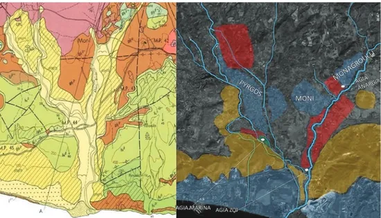
Figure 1: Geological map and satellite view of the area of the project.
Satellite image legend: Red: Areas intensively surveyed; Yellow: Areas judgmentally surveyed due to unsuitability for intensive survey; Blue: Urban areas, unsuitable for intensive survey.
The Moni river valley presents a wider and smoother river bed with large colluvial terraces for the middle valley, with greyish and creamy clays, and ophiolites, ser-pentines and other igneous rocks of volcanic origins, for the upper valley, which is particularly suitable for metal mining, especially from Monagroulli up to the upper river terraces and ridges.
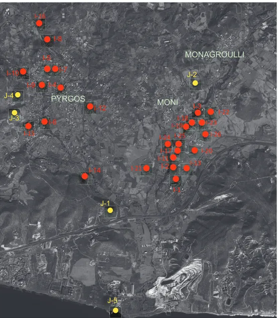
Figure 2: Location of the main scatter sites.
The landscape is variable too, as the area just at the back of Monagroulli and Ma-zokambos is quite mountainous, the ridge of the Pyrgos area is hillier, the mid Moni valley presents wide and plain river terraces, while the coasts change a lot from the rocky and steep cliffs just to the west of Agios Georgios Alamanos, to the flat beaches at the estuary of the hydrographic system. Because of this variability, a team consist-ing of geologists and geoarchaeologists, is workconsist-ing on mappconsist-ing the topographic and geomorphological units (henceforth TU and GMU). The recording of the data for this aspect has been completed, and the team is now working on the post processing of the TUs and GMUs which will be of great help for the interpretation of data com-ing from the archaeological surveys.
Because of the richness of the area in minerals, especially copper and iron, a team consisting of a speleologist and an archeo-speleologist is working on the survey of old mines, which often show a long duration of use. Among many surveyed mines, caves and quarries, a possible ancient copper mine along the Pyrgos valley has already been mapped and documented (site I-16). It exhibits likely exploitation from the Classical to Medieval periods, before its abandonment, probably because the mineral vein was exhausted, and richer veins were found few kilometres to the north.
A team of scuba divers has also surveyed the coasts of this transect to document more completely the geomorphological units, and this work has already produced interesting results by locating the main points that are geologically suitable for docking, while some finds are in post processing. This information, combined with the results of the survey, upon the completion of the latter, is expected to provide significant insights on the relationships between inland sites and natural docks, as well as the role of coastal shipping.
Preliminary Results of the Survey
(Menozzi Oliva and Di Valerio Eugenio)
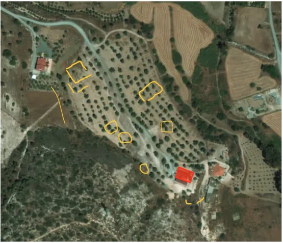
The six seasons of intensive survey (Fig. 1) in the last three years have been particularly productive. The mid Moni river valley transect, where the survey has been completed, (Fig. 3) is certainly the area most suitable for intensive survey, because of the plain river terraces. This area has continuously been surveyed since the first season in 2011, and has produced some interesting surface finds, suggesting a long settling in the area around Agia Zoi, as well as agricultural exploitation of the river terraces, both on intensive and extensive bases.
The interpretation of the possible scatter sites, which have already been delimited and located in the middle Moni valley, is now in progress. This entails a careful study of the finds to understand more properly the typology and chronology of the sites. Generally, the area is and was characterized by wide alluvial plain and fertile river terraces, which are and were largely exploited for agriculture, as the large quantity of amphora and dolia/pithoi sherds from the survey attest. Several interesting sites have been surveyed and analysed with geophysical methods in this area, and already at this preliminary stage of the research, it is possible to locate some farms and rural settlements dating to the Hellenistic and Roman periods.
The earliest finds in the mid valley of the Moni River seem to relate to a site, which is known from earlier investigations. In fact, in the area just to the south-east of Moni, Catling based on surface finds had suggested the existence of a settlement dating to the Early and Middle Bronze Age.7 Presently, we are carefully surveying the area 7 Catling (1963: 152 (No. 114)) dates the site to the Early Bronze Age. The location is around Moni
Station, mentioned by Cattling as Boudomandres and Voudomandres in cadastral map LIV 48.
Figure 3:
Mid Moni river valley fields surveyed during the six seasons. Fields with high percentage of pottery finds are marked in purple.
to delineate the buffer zone of this settlement, which is producing interesting finds already at this preliminary stage. Moreover, recent excavations by the Department of Antiquities indicate the probable location of this settlement’s cemetery.
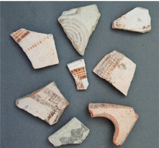
Scatter sites I-18 and I-26, which were located during the last season, show evidence for Late Bronze Age occupation. Apart from later finds, again belonging to the Roman and Late Roman periods, there is a quantity of good quality White Slip sherds (Fig. 4), dating mainly to Late Cypriote III A/B. It is still too early to say if these two sites can be interpreted as funerary contexts or settlements, because the analysis of the data is still in progress. However, a magnetometric/geo-resistivity prospection of the two areas is already planned for the next season, which could probably indicate the presence or absence of structures, tombs and so on.
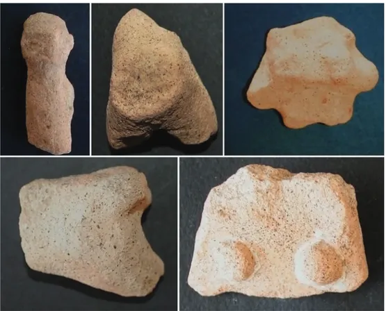
Scatter site I-13 looks extremely interesting because of the several fragments of terracotta figurines (Fig. 5), representing mainly horses or centaurs, as well as standing figures and a fragment of a miniature kylix. These finds suggest the possible location of a small shrine, which could be worthwhile to investigate via soundings. The location of the shrine is quite peculiar, as it lies on a river terrace and at the crossing point of ancient natural axes of the local road network running east to west, along the coast and intersecting here a track penetrating from the coast to the countryside, directing to the mountainous south-eastern slope of the Troodos, which is rich in minerals and raw materials. The area has also been surveyed with geophysical prospection and these analyses are still in post processing, but it is already possible to delimitate more properly the buffer zone of the possible ‘sanctuary’ in the cadastral plot 481 in sheet LVI-40. During the geoarchaeological prospecting and control of remote sensing anomalies, more sherds have been found. The numerous terracotta figurines, which have been found, although not very well preserved, seem to date to the period
between Cypro-Geometric and Cypro-Archaic, but looking at the quantity of sherds belonging to later pithoi, amphoras and dolia, it seems plausible that the site was later reoccupied by a Roman/Late Roman farmstead.
The scatter sites around the Agia Zoi area, where five scatters (I-2, I-17, I-25, I.-24, I-19) have been located and delimited, appear to belong to a single settlement, which dates from early Roman times to the Medieval period, as the high frequency of sherds belonging to amphoras, pithoi and dolia indicate. The typology of amphoras, mainly Late Roman 1 and 2 and some African, the presence of both earlier and late sigillata from Cypriot, African and oriental workshops, and the presence of Imperial Thin Walled Ware suggest a chronological range, for the maximum exploitation of the settlement, between the 1st century BC and the 4th century AD. However, earlier finds, such as few sherds of Red Polished, as well as later finds possibly dating to the 15th and 16th centuries AD, suggest that the area had a long history of occupation, but the types of settlements differed. For example, small farms appear to be the norm for the Bronze Age period, while a possible contracted settlement with scattered farms is suggested for the later periods.
The scatter sites I-2, I-20, I-23, I-24, seem to be ascribable to small farms homogeneously spread around the main settlement of Agia Zoi, and are considered to probably be hierarchically associated with the main village for production and exchange reasons. The percentage of finds in these scatters is high and the types encountered mainly belong to storage and transport containers. The main chronological range of these sites is from the Imperial to the Late Roman periods. It seems plausible that these farms were related to the abovementioned larger settlement dating to the same period, and probably functioned as satellite production farms for the main village. The area just around the church of Agia Marina is extremely noteworthy for different reasons, such as location, topography, continuity of exploitation and settling, as well as typology of finds. The church is located on a regular river terrace to the south of Pyrgos village. Geologically the terrace is characterized by colluvial terraces, brownish and reddish clays and a limestone substratum; and is delimited to the north by a deep streambed, now dry because of a modern dam. The close presence of the stream guaranteed a continuous water supply system in the past.
Various reasons dictated a complete survey of the fields around the church, such as the presence of an old church with an ancient cult reusing earlier building material, and the results of the photo-interpretation and remote-sensing. As a result, the area around the church was intensively surveyed in 2012 and a geoarchaeological
non-invasive prospecting survey was carried out in 2013 with a preliminary post-processing of the raw results.
Looking at the finds, a large amount of stone tools and Red Polished pottery attest a wide settlement in the area dating to the Middle Bronze Age, established probably to exploit the quite rich superficial vein of chalcopyrite in the area and due to the existence of a rich water source, namely a branch of the Pyrgos river running just below the terrace. Examining the buffer zone of the Bronze Age finds, the scatter site seems to exploit completely the terrace of plot 270 (Cadastral map sheet LVI-39). The presence of sigillata and Roman Buff Ware also indicates the existence of a Roman site in the area, which could be probably interpreted as a small settlement or farmstead. Moreover, amphorae and pithoi, both Roman and Late Roman, attest also some economic role of the settlement (productive/storage).
Some interesting sculptures directly reused as building material in the small church of Agia Marina, such as fragments of Proconnesian marble plutei dating to the Justinian period, as well as an octagonal base for a column with double moulding, could attest an earlier basilica in the area, which was then spoiled and abandoned. Obviously, the surviving small church with a Medieval inscription on the door attests an eventual continuity in the religious use of the area between early Christian times and Medieval period.
The area has been surveyed intensively, and was also investigated with non-invasive geophysical methods, which provide in the ongoing post-processing, some very interesting suggestions of possible structures, especially in combination with the data coming from remote sensing and the geomorphological survey. We present here a preliminary report of the geophysical survey for this site, while the post processing of the other sites is still in progress.
The first result is just at the back of the church (Fig. 6), where already remote sensing has revealed a semi-circular anomaly and an alignment. The geoarchaeological prospecting is confirming the semi-circular anomaly, also suggesting that it may not be a proper structure, but a cut into the rocky bed, probably for the foundation of a structure. It is certainly too early for a definitive interpretation, but the pre sence of a rectangular area with a semi-circular anomaly suggests some sort of structure, maybe an earlier basilica, which was probably the original place of use of the Proconnesian plutei dating to Justinian period and the base of the column, reused in the later church.
The fields just to the south west of the church, which are part of the upper level of the terrace, show several anomalies coming from the echo of a close homogeneous limestone background, but three or four irregular structures, probably built with limestone rubble and stones, can be seen from the results of the geo-prospecting. The last section of the geoarchaeological survey is in the eastern part of the upper terrace to the south west of the church. It is a more limited area, which has produced quite regular anomalies, probably belonging to more orthogonal structures.
These preliminary results suggest how and where to conduct more intensive surveys in this terrace and we are currently in the process of associating the finds with the results of remote sensing and the geoarchaeological prospection. For instance, the area which presents circular anomalies both from remote sensing and from
Figure 6: Agia Marina area: Outlines of anomalies from remote sensing
geoarchaeological prospecting has produced finds probably belonging to the Bronze Age. The anomalies are circular because they could be the remains of foundations of rooms which collapsed irregularly. However, it is quite well known that the results from remote sensing and geoarchaeological prospecting must be carefully checked with soundings before providing definitive interpretations, but in the case of surveys, they are important to read the contexts of each scatter site and eventually plan a more detailed survey methodology or sampling strategy.
Beyond the above, in 2013 the transect of Agia Marina was widened and further intensive surveys were carried out in the surrounding areas with a sampling strategy of 40%. The surveyed fields have not produced finds, which suggests a long use of these fields for agricultural purposes, probably dependent to the settlement around the church. The few finds from this area date again to Roman and Late Roman times. Turning to the judgmental survey in the two valleys, it has been concentrated on two typologies of areas which were unsuitable for intensive methodologies, as follows:
- The very hilly areas, where the topography and orographic system do not allow a regular sampling strategy.
- The urbanized areas, such as the villages of Pyrgos, Moni, Monagroulli (see Appendix 1, below) or the coastal zone, where every ancient remains or reused ancient material has been located with a GPS and catalogued to study in post processing both chronology, meaning and typology of each single element. It is still too early to analyse the sites from the judgmental survey, because the data are still in early post processing phase, and each single find is now under careful study and analysis. However, what appears quite clear is that the main villages in this area (blue dots in Fig. 5), that is Moni, Pyrgos and Monagroulli, present enough finds suggesting a continuity of settlement from at least the Cypro-Archaic period to modern times. In some cases, as for instance in Monagroulli and Moni, some tombs and cippoi found in situ further suggest the limits of a Hellenistic to Roman period settlement, and they could be considered hegemonic sites in these periods, due to both the agricultural exploitation of the river terraces, as mainly Moni, and metal mining, as for instance Monagroulli, and probably Mazokambos.
Moreover, some of the hilly sites (yellow dots in Fig. 5) were used as control points along the coast line or on the ridges along the main branches of Pyrgos river. Some of them, such as the Kafkalloudi (J-3) and Koukkufani (J-4) sites, show interesting remains attesting oil or wine production, as the presses at Kafkalloudi seem to suggest.
Comprehensive documentation of the presses was completed in the last season and after CAD processing, they will be properly published.
The strong difference between the Pyrgos and Moni valleys, has probably determined a completely different organization of settlements and exploitation of soil and resources. The Pyrgos river was flowing in antiquity with a stronger pressure and a wider water capacity, but on a very irregular basis, causing a morphology of the valley typical of a canyon/wadi. This feature was certainly extensively exploited in antiquity, as per an interesting structure (I-8) along the river was found, documented and analysed by our project. This structure shows three phases of use, specifically Roman, Medieval and Lusignan restorations and partial re-buildings, and was used as a bridge-dam, probably for creating in these periods an artificial small hydrographic basin for irrigating the fields around, but mainly for serving the area of mining (I-16), located just to the north of the structure. Moreover, the area of the bridge-dam, which is known with the evocative place name of Dimmata, and of a small copper mine (I-16) which is probably just part of a wider system, is very rich in Hellenistic and Roman pottery, suggesting that a possible Hellenistic-Roman settlement was located there, in close relationship with the exploitation of the mines and the presence of abundant and drainable water, which is fundamental for mining practices, as well as needing also an abundant and high pressure water supply system.
These are just the preliminary results of the first seasons of the project, and further surveys and analyses need to be completed. As already mentioned, archaeological soundings will help in the stratigraphic interpretation of some of the sites, while post processing of results from remote sensing and photo-interpretation, currently in progress, will further aid the precise delimitation and contextualization of the scatter sites. The paleobotanical and archaeometric analyses are also at post processing stage, but only the protocols and preliminary results on Red Polished Ware are presented here, while the analyses of Coarse ware fabrics are almost ready, and a specific protocol for White Slip ware has been planned in collaboration with other colleagues working in the Limassol district. The non-invasive geoarchaeological prospecting is at the moment in progress and about 60% of the sites have been completed. For the 2015 season, we have planned, in collaboration with the Department of Antiquities of Cyprus, an excavation in one of the sites,8 aiming to start a series of archaeological tests, which are necessary to avoid misinterpretations of the surface data.
Appendix 1 - Judgmental Survey of the Urban Contexts
(Antonelli Sonia and Tornese Marzia)
A team of archaeologists working at the Research Unit of Chieti University, consisting of Maria Carla Somma,9 Vasco La Salvia,10 and Carmen Soria,11 was assembled for the purposes of our project. The activities of the team mainly concerned settlement dynamics in the region with a view to determine the historical, archaeological and topographic context of the area, through an analytic and diachronic landscape study. During the first phase of the project, the team conducted focused surveys at settlements and territories whose geomorphological features did not allow for intensive survey. The results were then integrated with data from intensive survey, while a judgemental survey was planned to investigate a wider area and more properly contextualize the territory of the intensive survey. The latter includes eight main modern settlements from the sea coast to the Troodos foothills, about 650 masl, namely Moni, Pyrgos, Pentakomo, Parekklisia, Monagroulli, Asgata, Vasa and Sanida. The area hosts an articulated system of highlands which descend to the coast along the river valleys, a territory rich in mineral and wood sources situated at the hills and foothills of the Troodos mountain. These surveys shed light on issues related to the territory and settlements in the area, such as the relevant presence of sites related to the exploitation of mineral resources in this region, which guaranteed its richness since proto-historic times. Among the mineral rich districts, two localities seem to be particularly noteworthy, most of all for the large size of the associated sites. The first one is identified by the place name Listovonous (Northing-Easting Coordinates: 0514889-3850112), and is found within a wide hilly system, crossed by the main road leading from Parekklisia to Kellaki. The two hills are about 500 m high and have been highly exploited as mines, as the extensive terracing system and debris seem to indicate. Nowadays, iron veins are still visible and in some areas chalcopyrite remains have been detected. However, diagnostic materials have not yet been recovered, so it is difficult to pinpoint the period when the area started to be exploited, while the intense and continuous recent exploitation of this mineral district erased the traces of earlier testimonies. A large mine has been found 1km north of Asgata (Northing-Easting Coordinates: 0522583-3849506, 223 masl) situated to the east of the main road that leads from Asgata to Vasa, which in turn probably follows an ancient track. In this area, mineralized veins are 9 Lecturer of Medieval Archaeology at the University of Chieti.
10 Archeometallurgist at the University of Chieti. 11 Late Medieval Archaeologist.
still visible, as are the post holes in the façade of the mine for scaffolding supporting the extraction in remote areas. Moreover, the mine had a vaulted roof, which partially collapsed after intense quarrying, probably with a central pillar. The river course was partially directed towards the mining area using artificial structures capturing the water. Generally, the area shows traces of metal working, roasting points, furnaces and especially a considerable amount of waste and debris.
Another site of interest, mainly due to the finds dating to late periods, is the church/ area of Agia Marina, south of Pyrgos. The church is built on a little artificial terrace and its structures appears to be deeply modified by modern reconstructions and the interior is completely plastered. Surveys in the adjacent area showed continuity of life since prehistoric times. Among the finds, two little marble pillars are noteworthy, which have been reused as building materials in the apse window of the later church. This kind of pillars for plutei date to the 6th century AD and find good parallels with the Byzantine (probably Constantinopolitan) presbytery fencing elements in the church. The two pillars are fragmented, the first one is 65 cm high and 18 cm wide and shows at the centre a slot 3,5 cm deep; while the second one is 50 cm high and 18 cm wide. On the north side, the structure is built directly on bedrock and on the same side, a small well laid against the church wall survives. In the square of the church, there stands a large column base made of local soft limestone.
Little is known about Marina as a Saint. According to historical sources she was martyred in Antioch, and gave birth to Vitae and Passiones of four different saints, namely Marina-Marino, Marina-Margherita, Pelagia-Pelagio, and Pelagia called Margherita. The martyrdom, following the Greek “passio”, ascribed to some Timoteo, could have taken place during the age of Diocletian by beheading, but some details on the Saint’s life seem to justify her peculiar cult in the rural world. Marina of Antioch belonged to a rich family but retired to the modest life of a cultivator in the countryside, after being cast out by her father, until she was arrested for refusing to worship pagan gods and renouncing her virginity. One of the better-known episodes of her hagiography relates her fight with a snake-demon, and the details of this story resonate interesting connections to the island of Cyprus, which always had an ancestral relationship with snakes. Finally, the episode which leads to her beheading is followed by a strong earthquake. Given the seismic history of the Cyprus, it is considered self-evident why the worship of Saint Marina is very well rooted here, while it is worth mentioning that in a range of few kilometres from this site, there is another Agia Marina church.
Turning to urban settlements, two main topics emerge. Firstly, the strong presence of Roman material reused in modern buildings, and secondly the role of Christianization dynamics and ecclesiastic organization. These topics are henceforth explored by presenting current data on the best surviving settlements and comparing the data with the arguments set forth by scholars working on later phases.
The settlement of Parekklisia is characterized by a small ancient core, while the modern quarters developed to the south west. The ancient core runs around the Church of Timios Stavros and is characterized by a very irregular urban plan with tight streets. The centre is on a highland plateau and the main road which runs N-S, corresponds to the main ancient road, as the local geomorphology forced the continuous use of the same road tracks. The ancient centre of the settlement, is also placed between the main road and a road track that connects it to Pyrgos. As suggested by the toponym, Parekklisia must have developed around a church that may have had a monastic function and was possibly related to the Cistercian Order. This argument relies on the monastic structure, which can be readily identified by the negative mark left in the actual urban plan, south of the church. The fields around the area, may have been related to the monastery for their agricultural exploitation, as well as a possible farming area to the east of the church (in front of the actual cemetery), named with the toponym Palaios Mylos, where a small modern shrine is also located, which has been built just on the top of a semi hypogeal room, which in turn is probably part of a Hellenistic or Roman grave. The square hypogeal space is 185 cm long and 115 cm wide, with a height of 96 cm and a vaulted roof. This space can be entered through a small opening (86 cm wide, exterior height 86 cm, interior height 96 cm) on the eastern wall. The masonry is realized with regular limestone blocks, while the vault is built with smaller limestone slabs. On the ashlars masonry remains of plaster, or less possibly hydraulic mortar, can be seen. The structure is based on squared pillars 25cm high, which are laid directly on the bedrock. It is considered plausible that Hellenistic-Roman tombs were in this area, as in the suburbs of the actual settlement, and more particularly at Scalon street, a funerary cippos was found in a private garden.
The church of Timios Stavros preserves the original one-nave plan with a wide apse despite later renovations and rebuilding. The edifice, oriented to the east, presents a central entrance and two lateral entrances on the south side, one of which has been walled, while the other was rebuilt in 1851. The church shows the usual counterforts on the long sides and has been built using local limestone for the masonry filled with smaller blocks and stone. Some of the squared blocks exhibit tool marks, especially
chisel and gradin. Moreover, some earlier architectural element, which has been reused in the masonry can be identified, dating to the Middle Ages, especially the architectural decorations of the walled portal. Again, on the south side, it is preserved the structure of a small square well reused on the wall. Inside, the nave in the first span features a compressed arch that supports a small matroneum, which is accessible from the stairs at the left of the main entrance. The presbytery area and the apse are decorated with badly preserved wall-paintings and at least three scenes can be identified. These include the representations of Archangel Michael, Saints Peter and Paul and the Madonna with the Baby in the apse. Finally, a program of conservation and restoration of these wall paintings is in progress.
The settlement of Moni is on a deviation of the main north-south road and seems linked with Pyrgos and Monagroulli by two secondary axes (Northing-Easting Coordinates: 3473848-03320185). The site is placed on the top of a hill used for intense cereal cultivation. The modern settlement preserved an irregular urban plan around the Church of Agia Zoni, while in the eastern area seems to be more regular, especially along the main road. This arrangement does not seem to have changed through the ages, because of its geomorphologic features. This continuity in urban planning can be attested for instance by 6 Roman funerary cippoi discovered in situ in private gardens along the main north-south road. Two more stele have been identified on the road connecting this centre with Monagrulli. Moreover, in some private gardens, certain ancient architectural elements are still preserved, such as the two sarcophagi fragments, and a fragmentary column in a house on Kostaki Panagiotou Street. The church of Agia Zoni seems to preserve the original plan with one nave and round apse. The masonry of the east oriented building is not visible because it is plastered both inside and outside. The only visible masonry is on the counter forts, which are structured with squared blocks of local stone, placed in regular rows.
Monagroulli is located at a small distance from the main north-south road and was linked with Moni by a secondary east-west road. The settlement is built on a low and irregular hilly ridge (Northing-Easting Coordinates: 3474796- 03321243) and presents an irregular urban plan. The church of Agios Theodoros is located on a small plateau south of the settlement, which, despite the heavy restorations, still preserves the Cistercian plan. Moreover, in its courtyard, a cippos and a capital, probably dating to Early Roman times were found, while the base of a column discovered among the remains of an old abandoned house can also be dated to the Roman period. The latter is made of local limestone, has a diameter of 45 cm, and was partially damaged by
a crumbling wall. Three more Roman funerary stele have been mapped within the modern settlement, while a piece of a column made of local stone is still preserved in the wall of a modern house. The main church is Agios Theodoros and preserves the original one-nave plan with a polygonal apse. The building is east oriented and its masonry is not visible because of the plaster covering both the interior and exterior surfaces. Again, the only area where the masonry is still visible is on the base of the building, namely the counter forts, which are built with squared blocks in local stone and laid down in regular rows. The building technique consists of sub-regular rows of mid-dimension squared blocks with mortared stone rubble fillings. The plan is very similar to the aforementioned Churches at Parekklisia and Moni. In the lower part of the southern suburbs, the modern Church of Agia Paraskevi, whose back leans directly on a vertical limestone slope, preserves just at the back of the modern iconostasis the remains of Hellenistic loculi of the Alexandrine typology with a sloping roof, which is quite popular in Hellenistic and Roman Cyprus, and finds parallels at Paphos and Kourion. Nevertheless, they are very badly preserved and have been found totally empty.
Appendix 2 - Pottery Finds and Archaeometric Protocols
(Agostini Silvano, Giobbe Marcella, Mancini Maria Cristina
and Di Nino Serena Torello)
The Earlier Pottery Finds from the Survey
(Di Nino Serena Torello)
The earliest pottery from the survey is mainly Red Polished (mostly RP II and III) sherds (83%, within the Bronze Age ceramics), but also includes pithoi (10%), while the remainder are White Slip sherds (7%).From preliminary quantitative analysis, most of the RP is characterized by closed forms, such as jugs (55%) and jars (27%), a probable indication that this area was largely exploited for agriculture, perhaps oil and wine production, as the large quantity of amphora and dolia/pithoi sherds coming from the survey attested for later periods. In this case, the 10% of the early dolia/pithoi, which were used for the conservation of the foodstuff, can be easily included in this contextual typology.
The sites from which this pottery was found, are in strategic areas, like site I-12 in the area known as Palaeo Lakkos (Cadastral Map Coordinates: LVI-31: Plot 539), to the west of modern Pyrgos and close to a possible ancient passage between Pyrgos and Moni districts.
The open forms, mainly bowls, represent only 10% of the assemblage, and were mainly found at site I-4 (Cadastral Map Coordinates: LIV-31: Plot 1444), in the area marked on the cadastral maps as Patthia, just to the north of Pyrgos.
The discovery of Late Bronze Age 3A/B White Slip sherds of quite good quality, both in fabric and in surface decoration, at two scatter sites (I-18 and I-26) is considered particularly important. The two sites seem to be quite close and they were probably closely related. I-18 is on a plain river terrace just to the east of Moni, along the main road going to Monagroulli and up to the Troodos. The typology of location, its to-pography and geology seem to suggest a possible site for burials. The second scatter, I-26, is just 500 m to the east, on a strategic hilltop location that is inter-visible with the surrounding fields. This second site has also produced sherds dating to the end of the Middle Bronze Age.
Currently, the Bronze Age finds from this territory are still too scanty to identify an evolution of settlement throughout this long period or to investigate the hierarchic role of the sites. It is also important to point out that most of the area of Pyrgos has a long continuity of urbanization, and there is not much territory left to investigate how the settlement distribution was organized in this area. It will probably be easier to do this for the Moni and Monagrulli contexts.
Roman Pottery Finds
(Mancini Maria Cristina)
Pottery is considered one of the most important indicators of Roman presence in Cyprus, and in general remains a fundamental analytical category in the field of clas-sical archaeology, while it is also particularly important for the Roman archaeology of the island, especially for the later periods. Changes in this critical category are often attributed to historical and territorial factors operating in the context of the development of Mediterranean trade and economy. Moreover, the utilisation of in-teractive technologies, archaeometric methodologies and paleobotanical analysis has significantly increased the amount of information regarding the production and cir-culation of pottery over the past two decades. In this project, fabric composition was examined via chemical, mineralogical and microstructural characterization of the samples,12 and the preliminary results of this analysis allows us first to distinguish 12 See below for the protocol and the chemical analysis. The study of lime provenance is in progress,
Roman sites in the area of the project, and secondly to identify different fabrics and typologies, using specific archaeometric analytical techniques.
Nevertheless, the interpretation of Roman pottery is rendered problematic by several factors, and most notably the fact that the researcher often has at his/her disposal only records from poorly excavated archaeological sites. Generally, the typology of the Ro-man and Late RoRo-man periods at the area of the project presents a high percentage of Coarse Ware (32%) and amphorae (28%), especially LR 1, 2 and 3, found during the surveys. The early (7%) and late (16%) sigillata and the thin walled ware (9%) represent the finest pottery in this area during the Roman period. The quality and quantity of late sigillata indicates that there was a special trade relationship with both African and East-ern production centres. These important types of pottery began to be imported from the 3rd century AD. There are very small quantities of Cooking Ware (4%), Lamps (3%) and Black Glazed pottery (1%), but among the latter it is important to note one frag-ment probably from an Attic workshop. On a general note, the evidence from ceramic artefacts appear to suggest cultural, economic and political changes in the short-term histories of the ancient settlements, while at the same time they can be considered a sign of economic prosperity and agricultural exploitation of the territory. Moreover, the quantity and types of imports in these areas during the Roman period is very sig-nificant, as on the one hand they indicate that trade especially with the Near East and Northern Africa continued at an intensifying pace during the Roman Empire period, while on the other hand the archaeometric study of fabrics is expected to aid the clari-fication of provenance. Finally, the analysis of significant quantities of ceramic artefacts demonstrates the volume of trade and allow us to reconstruct ancient trade routes.
Protocols and Analysis
(Agostini Silvano and Mancini Maria Cristina)
Judging from the large amount of pottery fragments collected during our surveys, it seems reasonable to suggest that the sites were involved in the production and export of local products, as well as the import of materials and products from other Mediter-ranean lands, especially for the period between the Middle Bronze Age and the Late Medieval Age. The pottery dating to these periods, seem to confirm a large mainly agrarian production with numerous amphorae and other containers probably related with the production of goods and their export outside Cyprus.
The study of these pottery finds has been based on common protocols for our projects, both in Cyprus and in other areas of the Mediterranean basin, especially
Libya.13 According to this protocol, the first step is sampling the fabrics with a scanning microscope in the field to obtain a preliminary digital microscope analysis as the basis on which to collect samples. A second step at the location of discovery, is dedicated to the geomorphological analysis of the territory, which includes sampling of local clays, soils and sediments, carefully selected by geologists, in order to produce possible reference samples for local production. The final third step takes place in the laboratory and includes EDX and TSA analysis, which allow further grouping of the fabrics. It is clarified that only a limited number of fabric samples are chosen for further investigation, such as SEM analysis, with an additional fourth step dedicated to the more extensive and detailed analysis of problematic or highly particular fabrics. More than 100 samples of ceramic fabrics from Cyprus, dating from the Middle Bronze Age to the Late Medieval period, were collected in the first step of research. Next, they were grouped into main categories. At the moment, our sample base contains a high percentage of local pottery and a lower percentage of imported pottery, the latter mainly from the Near East, Mycenae and the Aegean in the Bronze Age, and principally from Northern Africa in the Roman period. Moreover, because the amphorae and other containers were exported for their contents, we are also trying to analyse any contents residues via gas-chromatography/mass-spectrometry, a task that is currently in progress and in need of more samples for successful completion. Petrographic analysis was also applied for the identification and chara cterization of both local and imported wares fabrics, with the goal of placing them within the geological context of Cyprus. A combination of petrological and technological techniques was employed, as fine pottery and amphorae cannot be studied only based on shape. The different compositions identified from the range of fabrics will eventually allow us to identify and distinguish the local from the imported wares, while typological and technological similarities will be studied within the geographical distribution of local and traded pottery. Presently, both the local and imported wares are examined in terms of technology (e.g. clay exploitation and manipulation), and show a great variety of attributes and important differences between the pottery groups in the region under study. Furthermore, we have carried out in situ microscopic examination of more than 100 different fabrics spanning the entire period under examination, and conducted geomorphological analyses of the project’s territory. The preliminary results demonstrate a prevalence of local pottery, which is almost certainly linked to the 13 Antonelli and Menozzi 2014: 885-895.
significant agricultural production and the presence of Roman farms in the area, which are also hinted to by the numerous amphorae fragments found during the surveys. The fabrics already selected are going to be grouped based on a series of features that include: composition, association with specific typologies and forms, and technologies employed in their production. Because grouping the fabric into main types and choosing which sample is to be used for further analysis is an important stage in the archaeometric protocol, we have established that this phase must be carefully monitored both by geologist experts in archaeometry and archaeologists aware of the need of both approaches to the study of the pottery.
The first step of cluster analysis has identified some homogeneous typological groups, such as the Red Polished for the Bronze Age, miniature wares for the Archaic Period, amphorae and fine wares for the Roman Age, and glazed pottery for the Medieval Period. We have started a diachronic research on the Red Polished ware found by our survey in the area, and subdivided this ware into six principal subgroups according to typological characteristics, which include: Fine Polished, Black Topped, Metallic Ware, Red Painted, Coarse Polished, and Uncertain. Having completed the typological study and the study of vessel shapes, the next step will include specific archaeometric analyses. Beyond these, the wares from the survey allow the study of distribution and economic interaction patterns in the area of the project. The imported wares attest to an interregional trade in specialized vessels with fabrics and forms adapted for particular functions, as well as significant trading networks extending across the Eastern Mediterranean and Aegean Sea that link Cyprus with Northern Africa and the Western Mediterranean. As such, this research provides important data on the ancient technology and economy of Cyprus, as well as the wider Mediterranean trade networks in operation from the Middle Bronze Age to the Medieval Period. Further archaeometric analyses will be carried out in collaboration with the Geological and Paleontological Service of the SBAA of the Italian Ministry of Cultural Heritage. More specifically, thin section and chemical analyses (microscopy, XRD) have been planned for select samples from the collected pottery assemblage. Compositional (MPC), and other technological data which are to be considered as a set including both cultural and environmental combinations (TCA), will be tabulated and compared in a standard database, according to the guidelines of an analytical protocol developed by the Geological and Palaeontological Service. Following data collection, statistical analysis will be carried out on the dataset of samples to distinguish the different clay pastes and manufacture technologies. Statistical
methods to be implemented include hierarchical clustering using Euclidean distances for all the variables and only for the paste variables (both using single and complete linkage clustering), and clustering using percentage differences for all the variables and only for the paste variables (both using single and complete linkage clustering). For this analysis, at least thirty-five variables will be considered, which include the following: minerals, fragments of sedimentary and igneous rocks, chamotte, fossils, “pedo-relicts” if present, and other similar petro-fabric typology, percentage and size of temper, paste typology (MPC-TCA), colour/colours of interior and exterior finishing surfaces of vessels in thin sections using the parallel Nicols, and others. The results of the study are expected to highlight the following: a. The minerals and petrographic components are anticipated to identify the main groups and single sample outliers. b. The differences between types in each group may indicate production technologies and the different degree of stylistic refinements. Up to the present time, preliminary results indicate that the tempering volume ranges in percentage between 5% and 30% in the coarse paste mixes of the main groups. Added to the above, the samples marked as imported amphorae and other containers (for instance from Northern Africa or Near East) exhibit a ceramic paste that is very different from the other samples. Evidently, the preliminary results of this investigation are promising enough to encourage future research by acquisition of new and different analytical data (XRD, X-ray fluorescence) from a larger number of samples deriving from other archaeological sites in Cyprus. Finally, the huge amount of data, deriving especially from the surveys, is collected into a GIS system in ESRI ArcMap, which functions as a useful geo-referenced archive accompanied by a large amount of information organised in different interacting layers. The data coming from the analysis and study of the pottery are included in specific layers dedicated to archaeometric data, the distribution of the fabrics, and the location of the main areas with specific clays, fine soils and sediments. These layers aid the elucidation of finds, fabrics and raw materials provenance, and at the same time allow comparisons with the layers concerning possible production sites.
Archaeometric Analysis on RPW: Preliminary Results
(Agostini Silvano and Giobbe Marcella)
This preliminary research has been focused on the distinction of frequently recurring fabrics of RP ware (connected with specific shapes and on a diachronic scale), and their macroscopic petrographical features. The samples for study are coming from different contexts and projects, such as the Early-Middle Bronze Age settlement of
Pyrgos-Mavroraki,14 and from the survey project of Chieti University in the territories of Moni, Pyrgos, Monagroulli, and environs.15 These sites are largely representative of the eastern Limassol district and allow the comparison of data regarding raw materials sourcing and manufacture technologies coming from sites situated in the geographically proximal Kouris,16 and Vasilikos Valleys. The archaeometric analysis has been performed in Cyprus with the collaboration of the Italian archaeological team of Chieti University, the Geological-Paleontological Service of the Italian Superintendence of Abruzzo and the CAAM (Centre of Athenaeum for Archaeometry and Microanalysis). Although this analysis represents only the preliminary step of a fully articulated protocol, it is already producing some interesting data that are also useful for defining the next steps in the research.
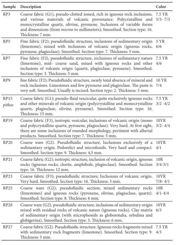
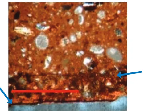
Based on digital microscope scanning of the Red Polished assemblage collected, it has been possible to classify samples from a petrographic point of view, and to define groups and sub-groups of different fabrics. This first step has been very helpful for the selection of samples for Thin Section Analysis (TSA). Generally, from the total average of the 12 analysed fragments, 11 RP fabrics and 1 RP fabric for storage vessels (pithoi) have been recorded (Tbl. 1). Each sample is identified by a code that combines the pottery class the samples belongs to with a serial number.
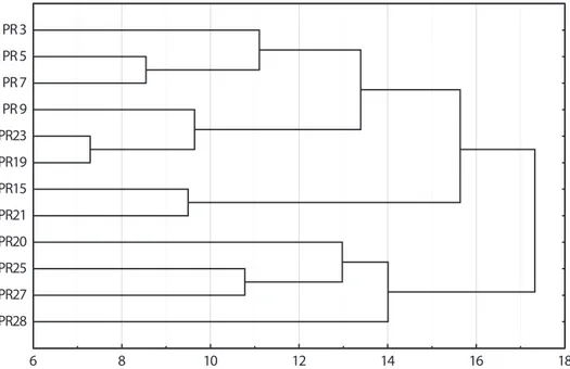
The second step of the analysis included the production of thin sections and their analysis with an optical microscope. This work has been useful for the extraction of as much information as possible on the mineral composition of the samples, and on other technological aspect, such as clay processing, fabric preparation techniques, and firing temperatures. Data from this analysis has been tabulated and compared in a standard database. Furthermore, statistical examination of the elemental dataset through hierarchical clustering was carried out to distinguish the different pastes and the production technologies (Fig.7). The statistical survey was based on the thirty-five variables previously mentioned, and indicated the presence of four recurring macro-groups (Tbl. 2). The differences between these groups are due to the different morphology of their mineral and petrographic components, as well as the production technology (surface treatment, manufacturing techniques, clay processing and fabric preparation technique among others). One more step, which is currently in progress, 14 For general information on the site see: Belgiorno 2009, with previous bibliography on the site. I must thank here the Director of the excavation, for allowing me to analyse the pottery sherds. 15 Mancini and Menozzi 2012: 195-201.