USE AND REUSE OF SPATIAL AND QUANTITATIVE DATA IN ARCHAEOLOGY: FROM 3D SURVEY TO SERIOUS GAME
AT PHAISTOS (CRETE) 1. Introduction
The role and the perception of archaeological research have undergone profound change in recent decades following two major shifts in underly-ing paradigms. The first is how Public Archaeology, once considered frunderly-inge research at best, has now gained significant recognition in the field of Cul-tural Heritage (Richardson, Almansa Sanchez 2015). The importance of outreach among scholars has grown considerably with the widespread implementation of new tools provided by digital technology. The second is how the digital revolution has driven new quality standards in terms of sur-veying and post-excavation activity, as well as the recording of discoveries and information in active databases.
While the development of highly accessible tools and software has undoubtedly facilitated progress and change, new challenges have arisen regarding first of all the efficiency and reliability of acquired data, and of the resulting communicated information. This is especially true for prolonged excavations involving even several generations of archaeologists. A new ar-chaeological project may well be planned from the onset according to a clear and organic strategy (from survey through to excavation and data storage up to communication), but sites that have been subject to excavation for a century or more suffer certain intrinsic difficulties. These include inconsistent and possibly unpublished documents, drawings and photographs that do not meet current standards, missing and unrecoverable data, and established narratives that stubbornly resist re-evaluation (Militello 2019).
With these provisos in mind, a 2014 project centred on the Phaistos Palace was submitted to the Greek Ministry of Culture (Carinci, Militello 2015) by the Universities of Catania and Venice. The “Beyond the Palace” project called for new soundings aiming at clarifying the relationship between the Palace and surrounding houses, as well as three further lines of research: the reorganization of all preceding documentation, and the digitization and communication of the same. The project included a new digital survey of the South-Western Quarter planned by the University of Catania and the CNR-ISPC in order to produce a 3D model that: a) provided a sound basis for scientific research; b) provided a reference for future diagnosis of building deterioration; c) allowed an immersive virtual experience of the area for vis-itors. The results were, however, not devoid of problems, and a collaborative
effort with the Department of Engineering of the University of Catania was set up in 2018 to extract the most from the acquired data and at the same time widen our perspective to include new concepts in communication such as gamification.
P.M., C.S., F.B. 2. The archaeological mission at Phaistos
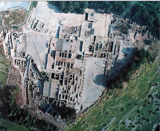
The archaeological mission of the University of Catania is currently working with the Scuola Archeologica Italiana di Atene (SAIA) in the archae-ological area of Phaistos, in the plain of Messara, Southern Crete (Fig. 1). The site (La Rosa 2010) has been excavated since 1900, first by Luigi Pernier (1900-1936), then by Doro Levi (1950-1966), Vincenzo La Rosa (1994-2004), Filippo Carinci (2013-2019), and Pietro Militello (2013-present). Other Italian
archaeological missions by the Universities of Pisa, Salerno and Rome La Sapienza have been working in the nearby area of Chalara, Haghia Photini and the surrounding territory (Bredaki, Longo 2015).
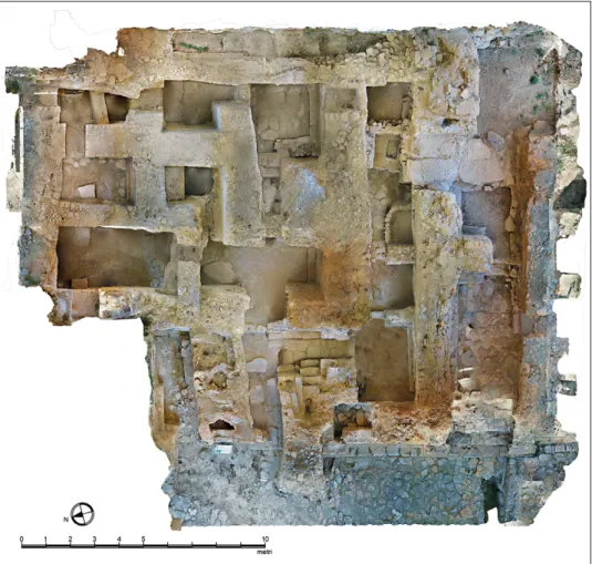
One hundred and twenty years of excavations have unearthed a set-tlement spanning from the Neolithic to the Greek period (3500-150 BC), with scant Roman and Byzantine occupation. Over more than three millen-nia, Phaistos represented the central reference point for Western Messara (Todaro 2013). Its more monumental phases included the Palatial period, with two successive buildings built one over the other (so called “First” and “Second” Palace, 1950-1700/1500-1450 BC), surrounded by houses, and the Early Greek city (Geometric Quarter). The most impressive Protopalatial is perhaps found in the South-Western Quarter (or “Quartiere Levi”), with a 3-storey, 5-meter-high building featuring a complex circulatory pattern linking storage rooms with others destined for ritual purposes on the ground floor, and domestic areas on the first floor. Spaces are narrow as expected for Middle Minoan architecture, with benches and niches. It was destroyed by the earthquake provoking the end of the First Palace, and preserved in a concrete and debris filling. The area is unfortunately not accessible to tourists or scholars.
P.M. 3. The digital survey
3.1 Survey of complex sites
The current digital technologies applied to Cultural Heritage surveying render three-dimensional acquisition of the investigated sites possible within known geometrical accuracy. Therefore, they permit an adequate and com-prehensive documentation of particularly complex sites, allowing the validity of the phase and function definitions developed for the studied structures. The numerical models obtained through the integration of several techniques (TLS, photogrammetry, SLAM, UAV), in addition to providing objectivity and reducing the acquisition time of all the relevant data, also allows a distinct separation from the critical reading phase (Docci et al. 2001) involving deep-er analyses according to multiple pdeep-erspectives ranging from intdeep-erpretation, conservation and enhancement through virtual instruments.
C.S. 3.2 Phaistos: the strategies of the topographical activity and of the archaeo logical survey
In the ten years between La Rosa’s excavations in Phaistos (2004) and the recent Palace research project conducted by the Universities of Catania
and Venice (2014-2020), archaeological research underwent profound changes in the field of survey driven by the diffusion of digital archaeology (Evans, Daly 2006; Earl et al. 2013; Forte, Campana 2016), which quickly set new standards. The push to upgrade the surveying methods at Phaistos can in any case be traced back to the methodological line traced by La Rosa (2001) and his interdisciplinary research project; in fact, the current surveying strategies continue today these hints of “contamination” and cooperation.
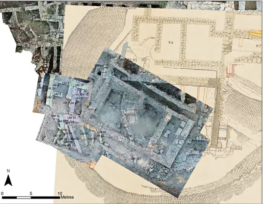
Regarding data management, a GIS platform of the Palace has been erected to promote the sharing and querying of the new research results and to commence systematisation of the enormous amount of pre-existing information (Fig. 2). It also ensures interoperability with the digital archives, including inventory catalogue, small finds (Figuera 2018) and Protopalatial pottery databases (Antonello 2019-2021). The survey method is based on traditional drawings as well as photogrammetry, which is then vectorized in CAD environments. 3D models of the trenches and structures derived from
Fig. 2 – GIS elaboration with old and new data in the Southern area of the Palace (F. Buscemi, M. Figuera).
image-based modelling constitute a real numeric and searchable database. The survey outputs have become the subject of a joint research project (“W.A.L.L. Project”) into new approaches to automatic image recognition and quanti-tative analysis of architectural features recently launched by the CNR-ISPC of Catania and the Université Catholique de Louvain.
As for the topographical activity, a GPS SAIA georeferenced grid based on trigonometric vertices of the local geodetic network by the Geografiki Ipiresia Stratou formed the reference for refinement networks and ground control points for excavations and photogrammetric surveys (Buscemi 2015). They were obtained by using a differential RTK positioning based on the local GNSS network Uranus. Two photogrammetric surveys in the Southern and in the North-Eastern area of the Palace were conducted in 2017 and 2018, respectively, using a base-rover system, in cooperation with the Ephorate of Antiquities of Herakleion.
F.B. 3.3 The SouthWestern Quarter: the onsite 3D digital survey
3.3.1 The 2014 campaign
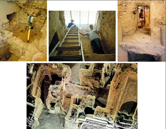
Along this line, a survey campaign was carried out in 2014 in the South-Western Quarter of the Palace. One particular objective was to use a zenithal view of a 3D virtual model to integrate the areas covered by the shelter into the aerial photogrammetry created within the Phaistos Project (University of Salerno). Laser scanning was done by the Garro’s Studio of Catania, 23 scans were acquired by a Leica ScanStation 2 (scan resolution: 4 mm from 0 to 50 m; scanner size: 265 mm ×370 mm ×510 mm; weight: 18.5 kg). They were georeferenced by combining the measurement of magnetic targets taken by a total station (Leica TCR 1203), which were in turn positioned on ground control points of a GPS polygon (Buscemi 2015).
The peculiar features of the South-Western Quarter unfortunately generated unsatisfactory results. The narrowness and inaccessibility of the rooms, the reduced distance between the shelters and the tops of the walls, and the unfavourable lighting conditions resulted in a point cloud with insufficient density, data gaps and poor colour data. The presence of fine sand further complicated the acquisition phase (Fig. 3). This surveying experience eventually demonstrated that laser scanning was not necessar-ily the best solution for certain archaeological areas, so a different digital surveying technique was adopted to improve on the previous results and extract value from the geographical and spatial information in the 2014 point cloud.
Thanks to the collaboration of the research group engineers, a new survey based on a structure-from-motion technique was carried out in 2019. The
Fig. 3 – 2014 survey: the difficult condition in data acquiring and the lacking point cloud.
Fig. 4 – Integration of the sheltered areas in aerial photogrammetry (courtesy of the Phaistos Project) with the South-Western Quarter, through the geotiff extracted by the 3D model (GIS elab. M. Figuera).
new point cloud was overlaid on the 2014 one, which was used as a basis for georeferencing and scaling of the new model. In so doing, one of the aims of the activities in the Quarter, the integration of the general photogrammetry of the Palace, was reached (Fig. 4). Beyond helping us respect certain time and budget constraints, the results seem to demonstrate the efficiency of the low-cost tools for the documentation of archaeological sites, encouraging the reflection among specialists about the reuse of data coming from different survey campaigns.
F.B. 3.3.2 The 2019 campaign
To integrate the data acquired during the 2014 survey campaign and obtain a complete numerical model with high quality colour data, a photo-grammetric digital survey was conducted in 2019. Considering the complexity of the environmental conditions (very narrow environments, bad lighting, a bulky shelter used to protect the excavations), it was decided to experiment with two surveying tools: a GoPro Black Hero 6 action camera with a lens to simulate the fisheye effect, and a Canon EOS 70D with a traditional lens. The results obtained from the two acquisitions were then compared to determine the more appropriate device in terms of ease of use, as well as completeness and metric accuracy of the acquired data (Aiello et al. 2019).
The GoPro proved to be the most suitable tool for the photogrammetric survey of complex environments: its small size (L: 62.3 mm, H: 44.9 mm, D: 32.0 mm; W: 118 g) and the ability to control the camera with a mobile device allowed us to reach points that were difficult to access (such as the top of the walls, acquired with the help of a telescopic rod). Its wide field of view (Wide FOV: 130°) also resulted in a smaller number of images required to map the Quarter (1872 images acquired with the GoPro, 3471 images acquired with the Canon), thereby simplifying both the surveying and the processing phases. The GoPro was also effective in the processing phase of the photographic dataset. In spite of the fact that the Canon camera point cloud is more pre-cise from a metric and chromatic point of view, the GoPro point cloud was more comprehensive as the tool used was able to acquire points that would otherwise have been beyond reach. Considering both the highly complex and irregular geometries of the environments, the most effective method for the archaeological study of the architectural complex and generation of a virtual model of the site was the photogrammetric survey conducted with the GoPro.
It is hoped that the 2019 survey may in itself represent a contribution to new surveying protocols for archaeological sites that resemble the Levi Quarter in terms of irregular surfaces, narrow spaces, particular chromatic characteristics, poor natural and artificial lighting, and physical obstacles.
3.4 Data processing
3.4.1 From point cloud to 3D model
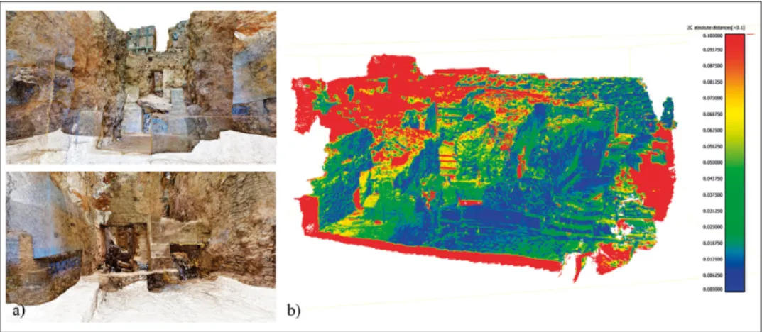
Having opted to use the GoPro Black Hero 6 camera, the photographic dataset collected was processed using the photogrammetric software Agisoft Metashape. During the alignment phase, 1836 out of 1872 images were oriented in order to generate a point cloud of the South-Western Quarter totalling approximately 160 million points (Fig. 5a). Given the superior ac-curacy of the metric information derived from a laser scanner, it was decided to compare the accuracy of the photogrammetric data with the laser scanner point cloud using CloudCompare. To achieve this goal, the photogrammet-ric point cloud was geo-referenced with the 2014 laser scanner point cloud. The alignment was performed using Metashape by assigning the coordinates extrapolated from the laser scanner point cloud used as the target model to 10 corresponding points from the photogrammetric model. The deviation between the two models is shown in a Blue/Red scalar field. The calculation range was set between 0.00-0.10 m (Fig. 5b).
By analysing Fig. 5b, the photogrammetric point cloud shows a mean value of 0.026047 m and a standard deviation of 0.015971 m from the laser scanner data. Note that the red areas as well as most of the orange and yellow areas should not be considered regions with inaccuracies, but portions of the photogrammetric point cloud where corresponding laser scanner data is not available because of the inability to sample many spaces due to its bulk. In areas where only camera point data are available, the colour difference rep-resents deviations between the photogrammetric point cloud and the nearest
Fig. 5 (a-b) – South-Western Quarter, a) views of the GoPro point cloud; b) results in terms of deviation between the laser scanning and GoPro point clouds visualized in Blue/Red scalar field.
available points in the point cloud. Ignoring the areas where respective laser scanner data is unavailable, the photogrammetric point cloud shows a suffi-cient degree of accuracy to confirm its validity.
Once the metric accuracy of the photogrammetric point cloud was verified, it was converted into a mesh with an associated texture generated by the photogrammetric software. The high resolution of the photographs (4000×3000 pixels) and wide angles covered by the shots allowed the software to build highly accurate renditions of the chromatic-material information related to the wall surfaces.
D.A.
3.4.2 From point cloud to 2D drawings
The South-Western Quarter is characterized by three different construc-tion phases that are clearly discernible within its complex spatial articulaconstruc-tion, as depicted in the sketches by Raffaele Oliva for Doro Levi (Levi 1976). The 2019 survey and the interdisciplinary techniques implemented by the research team resulted in the supplementation of existing documentation with addi-tional plans and sections extracted directly from the three-dimensional model and congruent with the current state of the structures.
There are two ways of obtaining two-dimensional representations from the point cloud and from the polygonal model. In the first, the operator iden-tifies section planes and the software uses automatic interpolation algorithms, which tend to generate somewhat irregular polylines with sharp angles. The second approach, in which the operator develops 2D profiles from appropriate point cloud slices (of about 0.02 m) set at different elevations, generates more satisfying results. As the interpretation of studied objects through appropriate graphical information is a critical feature of archaeology, the second method was applied to draw the profiles of the horizontal and vertical sections, while the projected sections characterized by plan and wall elevations were represented using orthophotos extracted from the textured polygonal model.
The GoPro photogrammetric point cloud enabled the generation of a more comprehensive model that includes areas that previous systems were unable to access, which in turn allowed the generation of new, more accurate two-dimensional representations. Among these, a geotiff file offering a zenithal view of the entire Quarter was extracted from the textured polygonal model, complete with wall textures (Fig. 6).
G.D. 4. Legacy and digital
The experience of the digital surveys in the South-Western Quarter of Phaistos was strictly interwoven with the topic of the legacy data (Todaro 2019). In IT, legacy data refers to information of significant interest or value that was created or stored using systems that are now obsolete. In digital archaeology, it represents information that is incompatible with contempo-rary digital practices and standards. Various kinds of legacy archaeological data exist, from handwritten sources (excavation diaries, paper notebooks, inventories) to photographs, drawings and maps, and there is always digital conversion operations. One way to avoid this is by adopting the FAIR princi-ples (Martone 2015) regarding the capacity of data to be findable, accessible, interoperable and reusable in terms of not only the integrity, provenance, transparency and reproducibility of data, but also of its interpretation.
4.1 Use and reuse of data
Data reuse is a highly contemporary topic of archaeological debate. Concerning the digital ones (Huggett 2018), the challenge is to distinguish between digitalisation and datafication (Gattiglia 2015, 115), which entails the transformation of objects and processes in a quantified format so they can be tabulated and analysed. In archaeology, the discussion (Clarke 2015) is often related to the digitization of traditional records and much less commonly to spatial and numerical data such as GIS shape files or point clouds (Faniel et al. 2013a; Bishop, Kuula-Luumi 2017). Our reuse of the metrical and spatial features of the 2014 point cloud was precisely along these lines and provoked considerable thought on the long term usefulness of data (Faniel et al. 2013b; Piwowar, Vision 2013, 175).
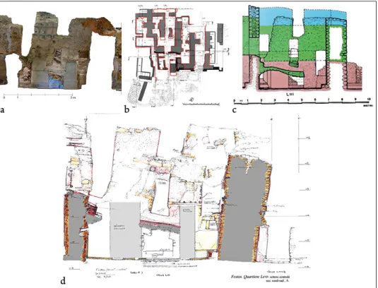
Fig. 7 (a-d) – South-Western Quarter, Room LIII a) profile extracted from the 3D model and inte-grated with the orthophoto of the elevation (elab. G. D’Agostino); b) plan by R. Oliva (from Levi 1955-56) overlapped with a profile from the point cloud (elab. G. D’Agostino); c) section by R. Oliva (from Levi 1976); d) unpublished section (courtesy of F. Tomasello).
At the same time, we had to consider the rich branch of studies con-ducted by certain Italian archaeologists on this architectural complex. Our digital surveys wanted to include specific archaeological questions such as the study of architecture (Tomasello 2001; Carinci 2011), the contextual analysis of findings (Caloi 2019), and the installations (benches and niches) (Baldacci 2011; Tagliati 2015). Concerning the relationship between our digital survey and previous studies regarding the South-Western Quarter, the 3D virtual model encouraged systematic review of the graphical documentation provided by Italian scholars and excavators at the complex since it was first laid out in 1950 (Levi 1951) 1.
The engineers and archaeologists in our research team compared sets of older drawings with corresponding profiles extracted from the point cloud and integrated with the orthophoto of the elevation, in a process that can provide much insight into the development of the methods and practice of traditional archaeological survey (Fig. 7a).
Specifically, we were able to demonstrate (Buscemi in press) how graph-ical documentation was impacted by changing approaches to archaeologgraph-ical research between the 50’s and 90’s, reflecting the growing body of knowledge and research techniques associated with the Quarter. The surveys in the first years of excavation from 1950 to 1953 were realized by the architect Cecilia Varetti (Levi 1952-54, 484). In this very early phase of research, the drawings were intended to simply mark the progress of excavations with little or no subsequent interpretation in mind. They represent graphical references of the single investigated areas and supporting material for specific archaeological conclusions. They are very schematic and devoid of any discussion on the architecture.
In 1955, the architect Enrica Fiandra began her collaboration with Levi (Levi 1955-56, 289; Levi 1956, 238). The excavation of the Quarter occurred in a large scale clearing. The surveys began to highlight the complexity of the architectural stratigraphy, and the priority of the graphical documentation was that to show as much was possible and to present such an “eye-catcher” for archaeological discoveries. An initial overall plan of the Quarter appeared in 1955 (Levi 1956, 239, fig. 2), followed by a more complete one in 1956 (Levi 1955-56, 293, fig. 4; Levi 1957-58, 194, fig. 1). From a graphical perspective, the ambiguous use of section and projection lines does not allow a clear iden-tification of the altitude of the representation plans. This is evidenced in the comparison of the general plan published by Levi in 1966 (1966, 314, fig. I)
1 The accounts by Doro Levi regarding the activity of the Scuola Archeologica Italiana di Atene
in the South-Wester Quarter were published in the «Bollettino d’Arte» between 1951 and 1956, and in the «Annuario della Scuola Archeologica di Atene» from 1955 to 1966, when excavation ended. Bibliographic citations of Levi’s articles in the text refer to these publications.
and the manual extraction from our 3D model of a horizontal profile of the Quarter cut at an altitude of m 1.70 above the western paved courtyard (Fig. 7b). Signed by Raffaele Oliva, it is clearly derived from the Fiandra survey and then integrated with the general plan of the Palace by Enrico Stefani (Levi 1966, 314, fig. I).
After Fiandra left the Mission of Phaistos in 1961 (Bandini 2003, 121), Raffaele Oliva became the surveyor of the Quarter (Levi 1961-62, 669) until the end of excavations in 1966 (Levi 1965-66). Oliva had a different background to Varetti and Fiandra who were architects. He was a draughts-man of the Superintendence of Antiquities of Campania in Naples, and as such, author of some watercolours of Minoan pottery (Levi 1957-58, 298). At the same time, Levi’s theoretical background and approach regarding the South-Western Quarter were shifting towards greater interpretation of structures, spaces, functions, layout of the Palace, and chronological phases. The surveys by Oliva are principally aimed to illustrate Levi’s theory on the presence of three phases of the First Palace, corresponding to the three floors of the South-Western Quarter (Levi 1976) (Fig. 7c). This is apparent in the extreme regularization of the ancient structures and the tendency for sche-matism characterizing his drawings.
It was not until the 90’s that archaeological research methodology at the complex saw significant change, thanks to the interdisciplinary project of V. La Rosa (2001) which focused on architectural themes that had never previously been addressed: the petrographical analysis of the building materi-al, the physical and chemical features of the constructive binders and, above all, the seismic response of the structures. The graphical documentation by architect Francesco Tomasello from 1995 partially published (Tomasello 2001) (Fig. 7d), mirrors these new interests and appears extremely sensi-tive to topics such as the collapse of structures following the earthquake of 1700 BC, geometric irregularities, and walls bond (e.g., stone masonry and timbers, floor engagement), in an extraordinary “visual discourse” on Minoan architecture, in our opinion going beyond any automatic process of data acquisition.
F.B. 5. Virtual fruition
5.1 Gaming approach in Cultural Heritage
In recent years, we have witnessed a paradigm shift in knowledge trans-mission through entertaining learning approaches aimed at capturing the attention of younger audiences. The gaming industry offers well-established experience in terms of design and involvement strategies (Mortara et al. 2014) that are often full of cultural content and historical contexts (e.g. the
video game Assassin’s Creed). Gamification is becoming an established trend in several cultural institutions, and the results of initial attempts such as the Father and Son mobile app at MANN (National Archaeological Museum of Naples) or MiRasna (an app developed for Etruscan museums) are encour-aging (see lastly Pompili 2019).
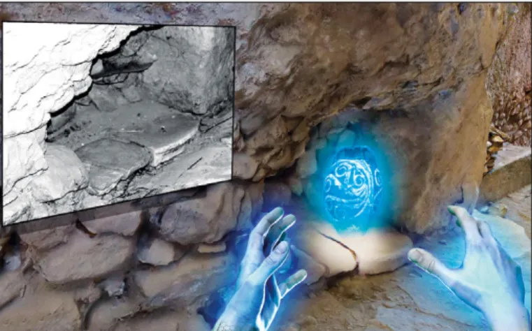
Beyond mobile apps, however, the idea of developing educational pro-totypes by mixing Virtual Reality, gaming and archaeological knowledge in museums or cultural sites, perhaps in which users can be immersed in and interact with virtual environments, can offer new alternative pedagogical and sensorial experiences (reveal VR European project), and possible open doors to new research avenues in the creative industry sector. In the specific context of this project, the inaccessibility of the Quarter as well as the will to involve the visitors in a sensorial experience brought to combine the gaming approach with the VR.
In literature, several educational games are aimed to engage the partic-ipants in exploring virtual reconstructed archaeological sites according to a playful learning paradigm. Among these: Protect the Walls! (Forlani et al. 2016), which deals with the technology and tactics of siege in the 4th century
BC; Hippocratica Civitas Game, where players visit the thermae of the his-torical site of San Pietro a Corte and Palazzo Fruscione in the city of Salerno, Italy (Andreoli et al. 2017).
Furthermore, the outputs of two European projects iMareCulture (https://imareculture.eu/) and RevealVR (https://revealvr.eu/) are represen-tative examples. iMareCulture aims in bringing underwater cultural heritage to the wide public: two meaningful outputs are The Seafarers game (Poullis et al. 2019) and Dry visit Baiae virtual tour experience (Bruno et al.2019) within the underwater archaeological park of Baiae. RevealVR is pioneering the use of PlayStation®VR for innovative educational applications, as in the case of ‘A night in the Forum’ game characterized by a thorough historical background and a validated 3D reconstruction of the Forum of Augustus (Ferdani et al. 2020). Thus, the VR experience will be aimed to guarantee a strong sense of presence through the faithful geometric reproduction of the spaces and architectural components, a high level of detail, the verisi-militude of the chromatic data, as well as the presence of interactive objects and surround sound.
C.S. 5.2 The archaeological supervision for the serious game prototype
Interpretation, reconstruction and communication are the challenges of contemporary archaeology (Volpe, De Felice 2014, 413). Especially concern-ing communication, we need to consider the real implications of vocabulary and innovative instruments, and not just technology for its own sake. From
this point of view, we decided to use the 3D model of the Quarter, realized specially to scientific reasons, to reach a wider public producing an educational package based on game techniques and learning through entertainment.
Therefore, the game was designed with the goals to provide the user with: (1) a better acquaintance with the Minoan world; (2) a direct experience of a section of the Palace currently not accessible to visitors; (3) a knowledge of spaces and artefacts from the Minoan period, understanding the organization of the rooms and providing information on their functions.
According to the requirement analysis, we determined the relevant needs and defined the project considering both the archaeological and engineering domains, combining innovative technological solutions and scientific accuracy. We wanted to create a dissemination, that can involve different levels of audience, starting from the local people, who continue to show a deep inter-est in their past, to the tourists attracted by the possibility to an immersive experience into the Minoan world.
We then identified the stakeholders: people interacting with the game (visitors of the Palace and scholars), and relevant institutions such as museums. In order to understand and document stakeholder expectations and needs, we conducted a survey through interviews and testing. The interviews with tourists highlighted the lure of the South-Western Quarter, currently not accessible, as well as the unfortunately disorienting complexity of the site and the limited information provided in guidebooks and on panels (Militello 2019).
Following these observations, participants at the Ergo Kritis Confer-ence (2019) were given the opportunity to try a prototype of an immersive navigation environment to better understand which features were taken for granted (dissatisfiers), which were unexpected (delighters), and which require-ments were explicitly demanded (satisfiers). We also looked at other relevant examples (Barandoni, Jasink, Valinoti 2019; Gheorghiu, Ştefan 2019) to help build our perspective.
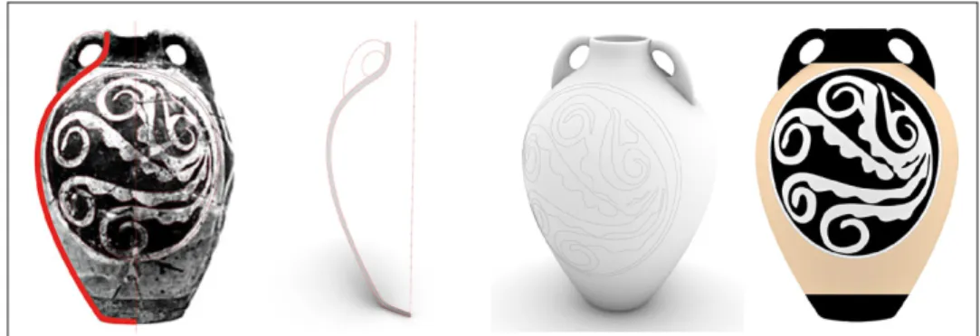
We decided to focalize the game on a specific and engaging topic that characterize the rooms of this Quarter: the ritual activities, and in special way the processing of liquids. In this process, archaeological supervision is necessary in terms of proposing fundamental aspects of the gaming experience and to uphold the accuracy of the underlying archaeological information. For this reason, we gave relevance to one of the most peculiar aspects of Phaistian architecture: the niches (doulapes), which were perhaps used to store artefacts for processing liquids for rituals (Carinci 2011; Caloi 2012, 49; Tagliati 2015). For example, through the game the user will learn, going around the Quarter in search of the niches, the use of the vessels and the function of the single rooms. The archaeological finds associated with these niches have been virtually recreated to stimulate research and learning. Players can learn the following details about the vessel recreated for our prototype game: a common
type of Protopalatial Minoan amphora, ovoid, polychrome and bilobata, used for liquids; found by Levi in 1952 inside the SW niche of room IL/0 (Levi 1953); forming a specific ritual set with the other artefacts in the niche; now stored in the Archaeological Museum of Heraklion.
In this way, the game represents a real opportunity for the project, as a tool able to add several aspects scientifically validated to the reconstruc-tion of this unique Minoan building. The game is set into a realistic setting, augmented by information about furniture and artefacts, and consequently allows the reconstruction of Minoan living habits.
M.F. 5.3 Game concept design: an interdisciplinary approach
The main aim of this research was to develop a realistic, immersive and interactive virtual simulation aimed at understanding, promoting and virtual accessing the South-Western Quarter of the Phaistos Palace through new methods of communication. Indeed this area is currently inaccessible both to the public and to scholars. The synergy of an interdis-ciplinary team made up of archaeologists and engineers, with expertise in computer graphics and communication, played a fundamental role in the creation of the storytelling behind the VR experience. The development of the experience has taken into account the above mentioned stakeholders, tourists and scholars expectations and needs, as well as the need to design an educational tool that would help in a better understanding of the site and its use in the past. The background for the VR experience is the model of the South-Western Quarter, set in the present day. The visitor is free to move around and interact with the area as the main actor of the experi-ence. In order for our game to actively involve and inspire participants, we introduced expedients to ensure vividness and realism, to increase the desire for exploration and to purvey the mysterious atmosphere of this complex, perceived as a labyrinth.
One of the possibilities envisioned is to introduce a 3D puzzle game, where the user explores the Quarter in search of niches with fragments of ritual pottery that are eventually pieced together into their original form. For each completed item, the player might be rewarded with bonus multimedia content regarding the finds and their archaeological context.
This first idea will be tested to understand its effectiveness. Indeed, the overall purpose of the serious game is to pique interest and curiosity, so that users want to explore the environment and participate in entertaining activi-ties that build their understanding and appreciation of the Minoan world in unconventional and appealing ways.
5.4 Prototype development
5.4.1 3D model optimization for VR environment
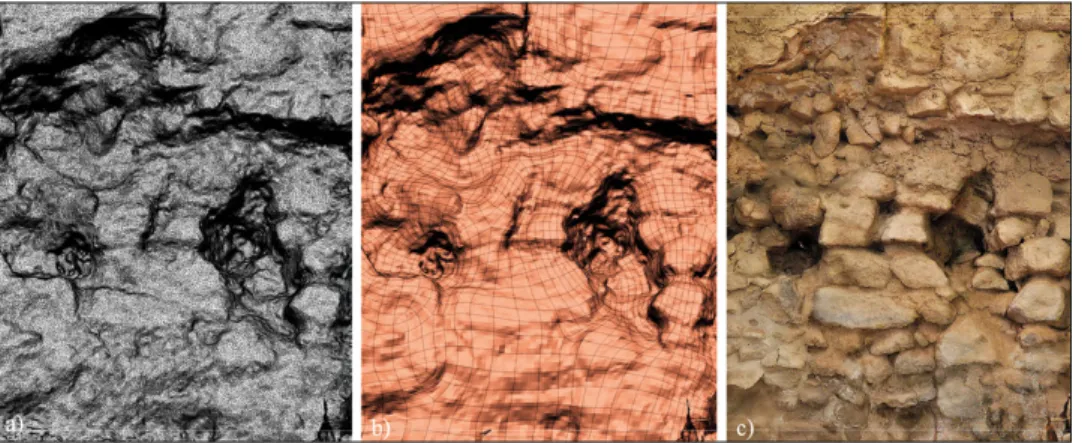
The triangular mesh is characterized by a very large number of polygonal faces that VR software struggles with. The mesh of the Quarter was there-fore imported into ZBrush, a computer graphics software that combines 3D and 2.5D modelling, texturizing and painting, capable of handling millions of polygons simultaneously. In this way, we could retopologize the meshes, thereby optimizing the number of polygonal faces and modifying triangular geometries into quadrangular counterparts that VR can manage more easily. To achieve this, the mesh was cloned so that the master model (Gaiani 2012) became the target reference model (essential to clone detailed information), and the clone was subjected to retopology. The level of detail of the target model was then projected on the retopologized mesh. After this operation, a UV map was created to enable the application of a 2D texture on the 3D model. To achieve this, the mesh was unwrapped on a plane with two co-ordinates for each vertex (X and Y). The texture was then applied on this plane, acquiring two UV coordinates (comparable to X and Y), which allowed correct application of the texture to the faces of the 3D model. The texture of the model was then optimized by eliminating the chromatic imperfections due to the bad lighting conditions at the site.
Comparison between the retopologized mesh and the master model showed that the number of mesh faces were reduced by 90%, from about 40 million to 4 million, but the reduced geometric accuracy of the retopologized mesh was not perceptible thanks to the high quality of the texture, and the visual level of detail remained almost unchanged (Fig. 8). In any case, the
Fig. 8 (a-c) – Mesh retopology process: a) non-simplified triangular model; b) retopologized qua-drangular model; c) final result of the textured retopologized mesh.
comparison revealed little deviation between the meshes, not exceeding 0.07 mm. The simplified mesh therefore provides sufficiently reliable information that remains scientifically accurate. As for the three-dimensional models of the vessels to be used in the virtual simulation, they are devoid of chromatic information, so we had to associate a texture to the surfaces modelled in Rhinoceros.
We tried several workflows, including projecting an image on the mesh using a ZBrush plugin (Spotlight) that allows overlapping a rectified photo on the mesh and using a brush to apply the colours of the image. While this method was effective, it ultimately required too much processing time. We therefore opted for another workflow which is equally effective but more automated and therefore less time consuming. Another ZBrush plug-in (ZAppLink) that combines ZBrush’s high mesh management capabilities with the full pictorial potential of Adobe Photoshop was therefore used to facilitating the creation of high quality textures from two-dimensional images.
D.A. 5.4.2 3D modelling of the pottery
To develop the VR prototype, some pottery vessels from the South-West-ern Quarter are digitally reproduced so the user can piece them together and return them to their original location. The reverse modelling process imple-mented for the digital reproduction of our artefacts involves the identification of the geometrical genesis of surfaces through the extrapolation of sample sections used as directrices and generatrices, aimed at creating a mathemati-cal model from a point cloud. The process can start from either survey data (laser scanner or photogrammetric point cloud) or archive sources such as photos or 2D drawings.
The reconstruction of the pottery was performed through the gener-ation of a revolved surface (Fig. 9). To identify the symmetry plane, the axis of revolution and the generating profiles of the surface, drawings and photos taken by field experts were used, as the amphora in question is currently stored in the Archaeological Museum of Heraklion and it was not possible to obtain a direct digital 3D acquisition. The interdisciplin-ary approach proved to be especially invaluable in the 3D mathematical modelling phase, given the substantial technical experience and knowl-edge required. The NURBS (Non-Uniform Rational B-Spline) surface of the archaeological find was created with the Rhinoceros 6 3D modelling software. These mathematical representations describe the 3D geometry of any shape with continuity and accuracy. The amphora was subsequently divided into four parts that the user will be forced to reassemble during the virtual experience.
G.D. 5.4.3 Development of the virtual simulation
To develop the virtual simulation, the optimized model was imported into the Unreal Engine game software with a relatively intuitive user mode based on the Blueprint Visual Scripting interface, which allows every instruction to be performed by connecting nodes instead of having to develop code in a particular programming language like C++. The next phase in the develop-ment of the VR experience was the choice of the device that would best suit the project objectives in terms of user immersion in the virtual environment. We decided to design our simulation for Oculus Rift (developed by Oculus VR) because it is cost-effective, easy-to-use, relatively small and compatible with the most recent versions. During the development phase of the VR, we endeavoured to ensure that the materials, lighting, and narrative elements comprising the overall experience were all of sufficient standard to achieve an appropriate sense of presence and high level of immersion and interactivity, including a teleportation movement mode to allow the user to move freely inside the virtual realm.
An interactive map visible in the top right of the headset display allows users to move around the South-Western Quarter and keep track of their position in the virtual environment, as well as the presence of elements of interest. At the beginning of the game only the entrance area of the map is visible, the other rooms will be unlocked once the player solves the 3D puzzle game. One of the key interactive components is given by the fragments of the vessels scattered throughout the site, which the user is invited to search for and reassemble by a narrating voice. A hologram of the entire vase is available to help the users reassemble the pieces correctly. Due to certain limitations of virtual reality tools regarding hand movement
Fig. 10 – Virtual Reality simulation. User experience.
Fig. 11 – Virtual Reality simulation. Blueprint of the 3D puzzle game.
and objects manipulation, the fragments were scaled up in size to facili-tate their assembly. Once all the fragments of the vase are placed in the right position, the scale of the vase is reset to its original size and is ready to be picked up and placed in its correct location (Figs. 10-11). On task completion, bonus content is provided in terms of historical information, notes about the Minoan civilization, and images relating to excavations and archaeological finds.
6. Conclusions
The team of the University of Catania brought their main objectives. One of these was the efficient reuse of legacy data from previous scanning activities to produce a complete 3D model of one of the most complex and important Minoan evidences, the South-Western Quarter of Phaistos. We implemented a cost-effective methodology constituting a repeatable survey protocol for similar archaeological contexts. The other objective was to de-velop an efficient and effective way of communicating the complex reality of the South-Western Quarter according to gamification strategies. In our pursuit of these achievements, we developed new procedures and methods that we hope future archaeological research projects might draw from in this era of economic sobriety and social challenges, for a more inclusive society.
At the same time, the fruitful collaboration between different disciplines, approaches and perspectives has brought certain questions to light regarding the interpretative versus objective nature of archaeological survey, and about the content of our outreach activity. Archaeology is interpretation, and the interplay between subjective and objective rendering of the monument is a top-ic of discussion. Something that we experienced first-hand in our endeavours, i.e. to temper the lure of Virtual Reality and its seemingly endless possibilities with the necessity to remain faithful to real archaeological evidence and the underlying educational objectives.
P.M., C.S., F.B.
Francesca Buscemi
Istituto di Scienze del Patrimonio Culturale – CNR [email protected]
Pietro Maria Militello, Marianna Figuera Dipartimento di Scienze Umanistiche
Centro di Archeologia Cretese Università di Catania
[email protected]; [email protected]
Damiano Antonino Angelo Aiello, Graziana D’Agostino, Cettina Santagati Dipartimento di Ingegneria Civile e Architettura
Università di Catania
[email protected]; [email protected]; [email protected] Acknowledgments
We thank the Ministry of Greek Culture and the Ephoria Archaioteton Herakleiou for permission to work on the Phaistos site, and the Scuola Archeologica Italiana di Atene for its support. The Archaeological Mission of the University of Catania at Phaistos thanks also the Tree Company and G. Polykretis for the generous support and dr. M. Spiridakis of the Ephorate of Antiquities of Herakleion for his precious work.
REFERENCES
Aiello D., Buscemi F., D’Agostino G., Galizia M., Santagati C. 2019, Low cost techniques
for the digital survey of a Minoan architecture in the archaeological site of Phaistos (Crete), in P. Grussenmeyer, A. Murtiyoso, H. Macher, R. Assi (eds.), Proceedings of the 6th International Workshop LowCost 3D – Sensors, Algorithms, Application, «ISPRS Journal of Photogrammetry and Remote Sensing», 42-2/W17, 31-38.
Andreoli R., Corolla A., Faggiano A., Malandrino D., Pirozzi D., Ranaldi M., San-tangelo G., Scarano V. 2017, A framework to design, develop, and evaluate immersive
and collaborative serious games in cultural heritage, «Journal on Computing and Cultural
Heritage», 11, 1, 4 (https://doi.org/10.1145/3064644).
Antonello S. 2019-2021, Un database dei depositi ceramici del MMIIB del Primo Palazzo
di Festòs (Creta). Per una revisione della cronologia dell’ultima fase protopalaziale, PhD
Thesis, Università Ca’ Foscari, Venezia, a.a. 2019-2021.
Baldacci G. 2011, Banchine protopalaziali a Festòs. Il caso delle strutture con riempimento
di vasi, in F. Carinci, N. Cucuzza, P. Militello, P. Palio (eds.), Kritis Minoidos. Tra dizione e identità minoica tra produzione artigianale, pratiche cerimoniali e memoria del passato. Studi in onore di Vincenzo La Rosa, Padova, Studi di Archeologia Cretese
X, Bottega d’Erasmo, 313-328.
Bandini G. 2003, Lettere dall’Egeo. Archeologhe italiane tra 1900 e 1950, Firenze, Giunti. Barandoni C., Jasink A.M., Valinoti I. 2019, New fruition of aegean archaeology: A board
game on Minoan Crete, in Proceedings of the 22nd International Conference on Cultural
Heritage and New Technologies (Vienna 2017), Wien, Stadt Archäologie Wien (https://
www.chnt.at/wp-content/uploads/eBook_CHNT22_Barandoni.pdf).
Bishop L., Kuula-Luumi A. 2017, Revisiting qualitative data reuse: A decade on, «SAGE Open», 7, 1, 1-15.
Bredaki M., Longo F. 2015, Phaistos Project. The results of the recent surveys in the land
and in the area of Phaistos (years 20112013), in Μ. Ανδριανάκης, I. Τζαχίλη (eds.),
Archaeological Work in Crete. Proceedings of the 3rd Meeting (Rethymno 2013), 3, Rethymno, University of Rethymno,453-464.
Bruno F., Barbieri L., Lagudi A., Cozza M., Cozza A., Peluso R., Muzzupappa M. 2017,
Virtual dives into the underwater archaeological treasures of South Italy, «Virtual Reality»,
22, 2, 91-102.
Buscemi F. 2015, Festòs 2014. L’attività di rilievo digitale, in P.M. Militello, F. Buscemi,
L’attività dell’Università di Catania a Festòs nel 20132014, «Annuario della Scuola
Archeologica di Atene», 93, s. III, 15, 293-302.
Buscemi F. in press, For a contribute on the history of survey at the Palace of Phaistos: The
SW Quarter, «Annuario della Scuola Archeologica di Atene».
Caloi I. 2012, Memory of a feasting event in the First Palace of Phaistos: Preliminary obser
vations on the bench deposit of Room IL, «Creta Antica», 13, 41-59.
Caloi I. 2019, Breaking with tradition? The adoption of the wheelthrowing technique at
Protopalatial Phaistos: Combining macroscopic analysis, experimental archaeology and contextual information, «Annuario della Scuola Archeologica di Atene», 97, 195-207.
Carinci F.M. 2011, Per una rilettura «funzionale» dell’ala sudoccidentale del Palazzo di
Festòs: il caso dei vani ILXXVII/XXVIII, «Creta Antica», 12, 17-125.
Carinci F.M., Militello P.M. 2015, Il Progetto “Festòs”. Il Palazzo e i suoi dintorni, «An-nuario della Scuola Archeologica di Atene», 93, s. III, 15, 207-208.
Carinci F.M., Militello P.M. in press, The results of the archaeological investigations of the
Universities of Venice and Catania in Phaistos in 20142016, in Δ΄ Παγκρήτια Επιστημονική Συνάντηση Αρχαιολογικό ‘Εργο στην Κρήτη (Rethymno 2016).
Clarke M. 2015, The digital dilemma. Preservation and the digital archaeological record, «Advances in Archaeological Practice», 3, 4, 313-330.
Docci M., Gaiani M., Migliari R. 2001, Una nuova cultura per il rilevamento, «Disegnare Idee Immagini», 23, 37-46.
Earl G. et al. (eds.) 2013, Archaeology in the Digital Era. Papers from the 40th Annual Con
ference of Computer Applications and Quantitative Methods in Archaeology (CAA), (Southampton 2012), Amsterdam, Amsterdam University Press.
Evans Th.L., Daly P. 2006, Digital Archaeology. Bridging Method and Theory, London-New York, Routledge.
Faniel I., Barrera-Gomez J., Kriesberg A., Yakel E. 2013a, A comparative study of data
reuse among quantitative social scientists and archaeologists, in iConference 2013 Pro ceedings, 797-800 (https://www.ideals.illinois.edu/bitstream/handle/2142/42099/391.
pdf?sequence=2&isAllowed=y).
Faniel I., Kansa E., Kansa S.W., Barrera-Gomez J., Yakel E. 2013b, The challenges of dig
ging data: A study of context in archaeological data reuse, in JCDL 2013 Proceedings of the 13th ACM/IEEECS Joint Conference on Digital Libraries (Indianapolis 2013), New York, ACM, 295-304 (http://dx.doi.org/10.1145/2467696.2467712).
Ferdani D., Fanini B., Piccioli M.C., Carboni F., Vigliarolo P. 2020, 3D reconstruction
and validation of historical background for immersive VR applications and games: The case study of the Forum of Augustus in Rome, «Journal of Cultural Heritage», 43,
129-143 (https://doi.org/10.1016/j.culher.2019.12.004).
Figuera M. 2018, Database management e dati archeologici: standardizzazione e applicazione
della Logica Fuzzy alla gestione delle fonti e delle attribuzioni tipologiche, «Archeologia
e Calcolatori», 29, 143-160.
Forlani M., Pietroni E., Rescic L., Rufa C., Antinucci F. 2016, Game embrace sie
gecraft in “Protect the walls!”, «SCIRES.IT», 1, 31-39 (http://dx.doi.org/10.2423/
i22394303v6n1p31).
Forte M., Campana S. 2016, Digital Methods and Remote Sensing in Archaeology. Archaeology
in the Age of Sensing, Berlin, Springer.
Gaiani M. 2012, Creare sistemi informativi per studiare, conservare, gestire e comunicare
sistemi architettonici e archeologici complessi, «Disegnarecon», 5, 10, 9-20.
Gattiglia G. 2015, Think big about data: Archaeology and the Big Data challenge, «Archäolo-gische Informationen», 38, 113-124.
Gheorghiu D., Ştefan L. 2019, Invisible settlements: Discovering and reconstructing the
ancient built spaces through gaming, in V. Geroimenko (ed.), Augmented Reality Games II: The Gamification of Education, Medicine and Art, New York, Springer, 83-102.
Huggett J. 2018, Reuse remix recycle: Repurposing archaeological digital data, «Advances in Archaeological Practice», 6, 2, 93-104.
La Rosa V. (ed.) 2001, I cento anni dello scavo di Festòs, Atti delle Giornate Lincee (Roma
2000), Roma, Atti dei Convegni Lincei 173, Accademia Nazionale dei Lincei.
La Rosa V. 2010, Phaistos, in E. Cline (ed.), The Oxford Handbook of the Bronze Age Aegean, Oxford, Oxford University Press, 582-595.
Levi D. 1976, Festòs e la civiltà minoica, Roma, Edizioni dell’Ateneo.
Levi D., Carinci F.M. 1988, Festòs e la civiltà minoica II, Roma, Edizioni dell’Ateneo. Martone M.E. 2015, FORCE11: Building the future for research communications and
escholarship, «Bioscience», 65, 7, 635.
Militello P.M. 2019, Phaistos: A memory for the future. How to tell an archaeological site, in E. Borgna, I. Caloi, F.M. Carinci, R. Laffineur (eds.), MNHMH. Past and Mem
ory in the Aegean Bronze Age. Proceedings of the 17th International Aegean Conference
(Venice 2018), Louvain La Neuve, Aegaeum 43, Peeters Publishers, 645-652.
Mortara M., Catalano C.E., Bellotti F., Fiucci G., Houry-Panchetti M., Petridis P. 2014, Learning cultural heritage by serious games, «Journal of Cultural Heritage», 15, 3, 318-325.
Myres J.W., Myres E.E., Cadogan G. (eds.) 1992, The Aerial Atlas of Ancient Crete, Los Angeles, University of California Press.
Piwowar H., Vision T.J. 2013, Data reuse and the open data citation advantage, «PeerJ», 1, e175.
Pompili I. 2019, Archaeology and Audience Development digital strategies: A research con
ducted with the team of «Archeologia e Calcolatori», in P. Moscati (ed.), 30 anni di
«Archeologia e Calcolatori». Tra memoria e progettualità, «Archeologia e Calcolatori», 30, 123-138 (https://doi.org/10.19282/ac.30.2019.09).
Poullis C., Kersten-Oertel M., Praveen Benjamin J., Philbin-Briscoe O., Simon B., Pe-rissiou D., Stella Demesticha, Markou E., Frentzos E., Kyriakidis P., Skarlatos D., Rizvic S. 2019, Evaluation of “The Seafarers”: A serious game on seaborne trade in
the Mediterranean sea during the Classical period, «Digital Applications in Archaeology
and Cultural Heritage», 12, e00090, (https://doi.org/10.1016/j.daach.2019.e00090). Richardson L.-J., Almansa-Sànchez J. 2015, Do you even know what public archaeology
is? Trends, theory, practice, ethics, «Word Archaeology», 47, 2, 194-211.
Tagliati A. 2015, Gli armadietti a muro di Festòs: tecniche e confronti, in A.M. Jasink, L. Bombardieri (eds.), ΆΚΡΟΘΙΝΙΑ, Contributi di giovani ricercatori italiani agli studi egei e ciprioti, Firenze, Periploi Collana di studi egei e ciprioti 7, Firenze University
Press, 295-315.
Todaro S.V. 2013, The Phaistos hills before the Palace: A contextual reappraisal, Milano, Praehistorica Mediterranea 5, Polimetrica.
Todaro S.V. 2019, Riscavare lo scavato. Building up the stratigraphy of Prepalatial Phaistos
with legacy data, Roma, Quasar.
Tomasello F. 2001, L’architettura. Considerazioni preliminari sull’articolazione degli spazi, in La Rosa 2001, 407-432.
Volpe G., De Felice G. 2014, Comunicazione e progetto culturale, archeologia e società, «Post Classical Archaeologies», 4, 401-420.
ABSTRACT
The article presents the results of a wider research carried out by a multidisciplinary group (archaeologists and engineers) of the University and the CNR-ISPC of Catania in the South-Western Quarter of the Minoan Palace of Phaistos (Crete). The article focuses on two digital survey campaigns carried out respectively in 2014, laser scanning, and 2019, Structure from Motion. Starting from the point cloud by laser scanner, the most recent, low cost and user-friendly photogrammetric tools (GoPro camera and software Agisoft Metashape) have been used during the 2019 campaign in order to update and to improve the previous dataset, which was used as a grid for georeferencing and scaling the new virtual model. Special atten-tion was addressed to the comparison of the two datasets and to the reuse of the first one for georeferencing and scaling the second one. Furthermore, the research has been focused on the opportunity to exploit the obtained virtual model both for scientific purposes and for the out-reach. The lack of accessibility of the South-Western Quarter of Phaistos Palace to the visitors attributes a special interest to this output. The virtual environment thus realized constituted an ideal starting point for the development of an educational fruition project based on a Serious Game approach. The cooperation of archaeologists and engineers in the development of the Phaistos game ensures a gaming experience not only pleasant but also provided with a strong educational profile.