The CoCoNet Consortium (2016) Vol. 6, Supplement
Ferdinando Boero , Federica Foglini , Simona Fraschetti , Paul Goriup , Enrique Macpherson , Serge Planes, Takvor Soukissian , The CoCoNet Consortium.
CNR ISMAR , Italy - CONISMA, Italy - NCB, UK - CSIC, Spain - CNRS, France - HCMR, Greece - The CoCo-Net Consortium
Corresponding author: Ferdinando Boero, email: [email protected]
CoCoNet:
TOWARDS COAST TO COAST NETWORKS OF MARINE
PROTECTED AREAS (FROM THE SHORE TO THE HIGH AND DEEP
SEA), COUPLED WITH SEA-BASED WIND ENERGY POTENTIAL
Abstract
This volume contains the main results of the EC FP7 “The Ocean of Tomorrow” Project CoCoNet, divided in two sections: 1) a set of guidelines to design networks of Marine Protected Areas in the Mediterranean and the Black Seas; 2) a smart wind chart that will allow evaluating the possibility of installing Offshore Wind Farms in both seas. The concept of Cells of Ecosystem Functioning, based on connectivity, is introduced to define natural units of management and conservation. The definition of Good Environmental Status, as defined in the Marine Strategy Framework Directive, is fully embraced to set the objectives of the project, by adopting a holistic approach that integrates a full set of disciplines, ranging from physics to bio-ecology, economics, engineering and many sub-disciplines. The CoCoNet Consortium involved scientist sfrom 22 states, based in Africa, Asia, and Europe, contributing to build a coherent scientific community.
Keywords
Networks of Marine Protected Areas, Mediterranean Sea, Black Sea, Biodiversity, Ecosystem functioning, Connectivity, Wind energy, Offshore Wind Farms, Marine Spatial Planning, Economic valuation.
1 1 6 5 4 3 2
The research leading to these results has received funding from the European Community’s Seventh Framework Programme (FP7/2007-2013) under Grant Agreement No. 287844 for the project “Towards COast to COast NETworks of marine protected areas ( from the shore to the high and deep sea), coupled with sea-based wind energy potential” (CoCoNet).
1
e-ISSN 2239-4303, DOI 10.2423/i22394303v6SpI
© CASPUR-CIBER Publishing, http://caspur-ciberpublishing.it
E
DITORIAL
.
A
S
UPPLEMENT OF
SCIRES-IT
ON
C
O
C
O
N
ET
E
UROPEAN PROJECT
Ferdinando Boero*, Virginia Valzano**, Cristiana Bartolomei**
*Coordinator of CoCoNet **Editor in Chief of SCIRES-IT Abstract
The Supplement to vol. 6, 2016 of SCIRES-IT contains the result of CoCoNet (Towards COast to COast NETworks of marine protected areas, coupled with sea-based wind energy potential), a project of the EU Oceans of Tomorrow programme (http://www.coconet-fp7.eu). The European Union requires Open Access to the results of the projects resulting from its support to scientific advancement. This is in full accordance with the policy of SCIRES-IT, an open–access eco-sustainable journal, which joins the main principles of the Berlin Declaration on Open Access with the aims of the International Convention on Biological Diversity. CoCoNet tackled two problems that are closely linked with each other: the protection of the marine environment and clean energy production. Hence, the Supplement is divided into two parts that, together, form a unicum.
Keywords
SCIRES-IT Supplement, Editorial, CoCoNet, networks of Marine protected areas, Mediterranean Sea, Black Sea, Offshore Wind Farms, Smart Wind Chart, sea-based wind energy.
The journal SCIRES-IT publishes in 2016 a Supplement to Volume 6 entitled “CoCoNet: Towards COast to COast NETworks of Marine Protected Areas (from the shore to the high and deep sea), coupled with sea-based wind energy potential”
This Supplement contains the result of CoCoNet (Towards COast to COast NETworks of marine protected areas, coupled with sea-based wind energy potential), a project of the EU Oceans of Tomorrow programme (http://www.coconet-fp7.eu). 1
The European Union requires Open Access to the results of the projects resulting from its support to scientific advancement.
This is in full accordance with the policy of SCIRES-IT, an open–access eco-sustainable journal, which joins the main principles of the Berlin Declaration on Open Access with the aims
1 CoCoNet Home page: http://www.coconet-fp7.eu ;
Abuot CoCoNet:
http://www.coconet-fp7.eu/index.php/about-coconet ; CoCoNET Documentary Film:
http://www.coconet-fp7.eu/index.php/coconet-documentary-film .
of the International Convention on Biological Diversity.2
CoCoNet tackled two problems that are closely linked with each other: the protection of the marine environment and clean energy production. Hence, the Supplement is divided into two parts that, together, form a unicum.
The first one is the Guidelines to design networks of Marine Protected Areas in the Mediterranean and the Black Seas, the second one proposes the principles to install Offshore Wind Farms in both basins, based on a Smart Wind Chart that couples environmental and economic sustainability.
The CoCoNet Consortium comprises hundreds of authors3 from 22 countries and 39 institutions. 4 They all deserve recognition for this volume as a
2 V. Valzano (2014): Editorial. SCIRES-IT an open–access
Journal eco-sustainable. SCIRES-IT, 4 (1), 1-4. Retrieved from
http://caspur-ciberpublishing.it/index.php/scires-it/article/view/10954/10197 3 CoCoNet Participants: http://www.coconet-fp7.eu/index.php/participants2 4 CoCoNet Partners: http://www.coconet-fp7.eu/index.php/partners 1 7 6 5 4 3 2 7
1 SUMMARY
1.1 A framework towards a holistic approach to sustainability the contribution of CoCoNet
1.2 Guidelines to create MPA networks in the Mediterranean and Black Seas 1.3 The Smart Wind Chart
2 GUIDELINES TO THE DESIGN OF EFFECTIVE NETWORKS OF MARINE PROTECTED AREAS 2.1 Rationale 2.2 Objectives 2.3 Building Networks of MPAs 3 PRACTICAL GUIDELINES FOR BUILDING ECOLOGICALLY COHERENT MPA NETWORKS 3.1 STEP 1: collect and organize all available information
From real world to geodatabase Architecture
Habitats in MPA networks Identifying and Mapping Environmental Threats Bioinvasions and MPA Networks
3.2 STEP 2: define spatially explicit management and conservation units
Connectivity underlies marine conservation Determination of connectivity
The holistic concept of Cells of Ecosystem Functioning
3.3 Step 3: identify networks and priority areas
Linking habitats, threats and costs to set conservation priorities
Introducing connectivity and oceanography into Marxan analysis
MPA network design from the standpoint of habitat-diversity, threats and conservation targets
3.4 STEP 4: Formation, management and monitoring of networks of MPAs What is a network of MPAs?
Selection of potential network nodes (actual MPAs)
Applicable legislation for designating MPAs and forming networks
Socio-Economic Aspects of MPA Designation and Management
Governance – local, regional, transboundary
Current management of existing Mediterranean and Black Sea MPAs
Future management: moving from single MPAs to MPA networks
Monitoring MPA networks
Gaps in Monitoring / Observation Systems for CEFs and MPA Networks 4 THE FUTURE: WHERE TO GO NEXT WITH MPA NETWORKS
5 REFERENCES IN THE MEDITERRANEAN SEA AND BLACK SEA
4 35 32 31 31 26 21 19 19 14 14 9 8 8 8 7 7 7 6 5 5 4 36 37 38 38 47 48 50 53 56 59 63 65
6 OFFSHORE WIND ENERGY IN THE MEDITERRANEAN AND BLACK SEAS: THE SMART WIND CHART
6.1 Rationale
DEVELOPMENT IN THE MEDITERRANEAN AND BLACK SEAS
7 APPROACHES AND POTENTIAL OBSTACLES FOR OFFSHORE WIND ENERGY 8 OFFSHORE WIND CLIMATOLOGY AND WIND POWER POTENTIAL IN THE 8.1 The role of wind in the marine system of the Mediterranean and Black Seas
MEDITERRANEAN AND BLACK SEAS
8.2 Wind data sources and relevant uncertainties
8.4 Offshore wind power under global climate change scenarios
9 OWFS AND THE MARINE ENVIRONMENT
9.1 Impacts of OWFs on marine biota: Lessons from Northern European Seas 9.2 The potential role of OWFs in MPA networks
10 THE SMART WIND CHART
10.1 Methodological background 10.2 Technical parameters and rankings for potential locations for OWF development 10.3 Environmental considerations
10.4 Integration of the acquired information 10.5 Results at the basin level
10.6 Results for the Mediterranean and the Black Sea pilot sites 10.7 A word of caution on the SWC results
11 CONCLUSIONS 12 REFERENCES
13 ACRONYMS - GLOSSARY OF KEY TERMINOLOGY 14 THE CONSORTIUM
8.3 Wind climate and wind power density for the Mediterranean and Black Seas
70 71 89 87 87 85 83 81 79 79 77 77 77 76 74 73 73 72 89 91 93 94 75 CoCoNet
1 Summary
The objectives of CoCoNet were the production of a Manual with the guidelines for the institution of networks of Marine Protected Areas (MPAs) and a Smart Wind Chart evaluating the feasibility of Offshore Wind Farms (OWFs), in the Mediterranean and the Black Seas. Both objectives call for the identification of spatially explicit
marine units where the management of human
activities takes into account the ecological patterns and processes featuring natural systems.
Previous and novel experience gathered in two pilot areas called for the recognition of cells of ecosystem functioning (CEFs): parts of the marine ecosystem (sea bed and water column) that are more connected with each other than with other parts. MPAs are meant to protect relevant habitats and the ecological processes that occur within their borders. MPA networks fulfil the strategic conservation objective of assuring, through the preservation of large-scale ecosystem functioning, the persistence of a good state for biodiversity. Habitats should be considered holistically to allow matching wind availability with compatibility of OWFs installation within the ecological units comprising MPA networks.
The core steps of the guidelines for the institution of Networks of MPAs are:
Step 1: collect all available information. The
data gathered during the project are stored into a
multilayered Geodatabase platform.
Step 2: Define spatially explicit management and conservation units. The CEFs were identified
based on oceanographic features, composition of benthic communities, propagules in the water col-umn and genetics of target species.
Step 3: Identify networks and priority areas
using Marxan, a freely available software that pro-vides decision support to conservation planning.
Step 4: Formation, management and monitor-ing of networks of MPAs, recognismonitor-ing seven core
principles: Representativity, Replication, Viability, Adequacy, Connectivity, Protection, Best Available Evidence.
The networks of MPAs are conservation, monitoring and management units that put in practice part of the programmes of measures that EU member states are setting up to attain Good Environmental Status (GES) as defined by the Marine Strategy Framework Directive (MSFD); thus, these networks constitute a vehicle for the implementation of the
MSFD. These visions should be expanded to non-EU countries, to enable a consistent use of the marine space: CEF management is effective only if it comprises the whole cell.
The Smart Wind Chart has been designed and
implemented considering mean annual wind speed, bottom depth, distance from shore, proximity to ports, electrical grid infrastructure, type of bottom sediments, coupled with environmentally restricted and sensitive areas (National protected areas/marine protected areas (MPAs), Ramsar/ Natura 2000 sites, coralligenous and maerl, deep sea corals, Phyllophora fields and Posidonia/ sea grass meadows). The design, permitting,
installation, operating and decommissioning of OWF involves:
Step 1: Consultation of the Smart Wind Chart results.
Step 2: Design and implementation of detailed local studies.
Step 3: Integration of the acquired information into a single framework
Step 4: Building of synergies with other marine space users.
OWFs should be developed according to wind availability and to suitability studies in the CEFs in which they will be nested, considering their role in the networks of MPAs.
The project applied the holistic approach to the understanding of marine volumes. The vision of CoCoNet has been fully embraced by the recent report of the European Academies Science Advisory Council and the EU Joint Research Centre on “Marine Sustainability in an age of changing oceans and seas”. A solid theoretical basis is now available, guiding a more holistic way to provide solutions leading to Blue Growth, to increase the economic capital while preserving the natural capital. The attainment of GES through networks of MPAs, and the production of clean energy through OWFs will be instrumental to the attainment of sustainable growth with an increase of blue jobs to enhance the knowledge of marine systems.
1.1 A framework towards a holistic
ap-proach to sustainability – the contribution
of CoCoNet
The protection of the natural capital in marine systems is the core of sustainable development,
as the Blue Growth initiative prescribes. The production of energy through fossil fuels is a major threat to environmental integrity and clean energy production is conducive to the preservation of the natural capital. To satisfy these two strategic aims, CoCoNet produced two pieces of work:
1.2 Guidelines to create MPA networks in
the Mediterranean and Black Seas
The first core objective of CoCoNet was the
definition of guidelines to establish networks
of MPAs in both the Mediterranean and the Black Seas, with a holistic approach to marine
conservation.
The persistence of valuable expressions of
biodiversity patterns (as those protected in
MPAs) is based on the avoidance/regulation of
direct threats (as enforced in MPAs) but ultimately
depends on the functioning of the ecosystems
at all significant scales, so requiring wise and
effective management throughout the ecosystem. The biodiversity and ecosystem functioning of a restricted marine space (such as MPAs and Sites of Conservation Importance) depends both on local features and on larger scale processes that take place outside the range of focused protection initiatives. Hence, the networks of MPAs must be
designed to maintain ecosystem functioning
throughout their extension, increasing the effectiveness of individual MPAs.
CoCoNet identifies Good Environmental Status (GES) as the main objective of the management of Networks of MPAs, and recommends effective actions towards the fulfilment of GES prescriptions. EU member states are responsible for the enforcement of the Marine Strategy Framework Directive (MSFD) in their own waters. Management and monitoring should be harmonized, based on
sound ecological principles. Since ecological
boundaries do not match with political borders, it is important that management and monitoring are coordinated among EU and non EU States bordering the Mediterranean and the Black Seas.
Socio-economic expectations must be consistent with the features of the environment otherwise,
in the medium-long term, the ecosystems will fail to provide essential goods and services, nullifying any short-term progress.
1.3 The Smart Wind Chart
The second core objective of CoCoNet was to
explore the possibility of installing OWFs in
the Mediterranean and the Black Seas, through the realization of a Smart Wind Chart (SWC).
The SWC identifies the areas in the Mediterranean and the Black Seas where two strategic requirements for the installation of OWFs are met: 1 – the availability of sufficient wind power to guarantee profitable energy production.
2 – the compatibility of OWF installation with the preservation of the natural capital and of its attractiveness/profitability for touristic and other socio-economic enterprises.
A Smart Wind Chart, then, synthesizes both opportunities (wind availability) and constraints
(biodiversity and ecosystem conservation, socio-economic potentials), fully embracing the vision of Blue Growth: the growth of the economic capital, to be sustainable, must not erode the natural capital. The achievement of GES, and its
persistence, is the measure of sustainability
and the objective of MPA networks is just to secure good biodiversity conditions by enhancing the functioning of ecosystems. The reduction in the use of fossil fuels and consequent clean energy production, furthermore, are coherent with the objectives of Blue Growth.
2. GUIDELINES TO THE DESIGN OF EFFECTIVE NETWORKS OF MARINE PROTECTED AREAS IN THE MEDITERRANEAN SEA AND THE BLACK SEA
issues require technical know-how to be properly understood and applied.
2.3 Building Networks of MPAs
‘Marine Protected Area’ means a geographically defined area of the sea which is designated or regulated and managed to achieve specific conservation objectives (cf. CBD 1992, Article 2). A network of MPAs comprises a suite of MPAs that are highly linked to each other by propagule fluxes (connectivity) and also considers the space wherein connectivity takes place. A network of MPAs will normally cover large geographical areas in order to ensure ecosystems resilience, increasing the resistance against natural and human driven impacts. In this regard, the often limited size of MPAs is a major shortcoming for their efficacy. It is vain to protect a minimal portion of the marine environment, while leaving the rest unmanaged and unprotected.
To cope with this problem, and to include the high and the deep sea into management actions aimed at protecting biodiversity, it is necessary to build networks of MPAs that are ecologically coherent and that use the MPAs as nodes of a much wider space. Networks of MPAs can be simply aimed at the coordination of management of each MPA through exchanges of good practices, without considering the space across the MPAs. However, these management-based networks can only improve the management of individual MPAs. An ecologically coherent network of MPAs must cover a volume of water and an area of sea bottom where the exchanges of propagules across marine space maintain full expressions of biodiversity and sustain ecosystem functions. Connectivity (i.e. the intensity of propagule exchange) is the main feature of an ecological network.
The design of networks of MPAs, thus, requires knowledge about structure (in terms of biodiversity expressions at the level of species and habitats) and function (in terms of connectivity). The networks have to be designed giving priority to solid ecological principles. Although political, economic and social imperatives have been demonstrated to be of critical importance for building successful protection initiatives, humans cannot expect that nature will adapt to their needs: in order to preserve nature (the scope of MPA networks) we must adapt to nature. MPAs are often, if not invariably,
2.1 Rationale
The manual provides the guidelines for designing, managing and monitoring networks of MPAs, centered on science-based criteria, concepts and models (physics, biology, ecology and evolution) but also takes account of socio-economics and legislation. The Cells of Ecosystem Functioning, in particular, provide a conceptual tool to guide ecologically coherent planning of human activities in the marine space.
The manual thus describes what knowledge is necessary to design MPA networks, providing a holistic view of the marine space. General recommendations for the establishment and management of MPA networks are given, covering habitat mapping, connectivity, oceanography, dispersal studies, beta-diversity studies, genetics, threats, objectives, socio-economic and cultural aspects, and applicable legislation.
Based on all this, a map of the networks of MPAs is produced, with special focus on pilot areas.
2.2 Objectives
This manual explains the rationale, processes and methods for selecting sites and establishing MPA networks in the Mediterranean and Black Seas, outlining general principles that are applicable to any marine environment. This manual of guidelines and recommendations is primarily aimed at: 1. Managers of MPAs and MPA networks 2. Policy makers
3. NGOs that focus on environmental protection 4. Local, regional, national and international au-thorities that should implement policies that aim at removing the threats to environmental integrity 5. The tourist and the fisheries sectors that derive benefits from good environmental status to gain their income
6. The scientific community
However, it should be noted that the in-depth comprehension of these recommendations by non-professional users might be limited since many
instituted to protect unique features of biodiversity as perceived by people, linked to the existence of important species (mainly vertebrates) or habitats (e.g. biogenic reefs, sea grass meadows), or special features of the sea bottom character as specified in the EU Habitats Directive. Zones closed to fisheries comprise habitats where the target species spawn, grow, and forage, but otherwise have restricted goals.
However, these traditional approaches neglect the importance of the dynamic three-dimensional nature of the marine environment. It as an environment dominated by volume, in which the water column is a specific major feature (itself comprising a range of habitats according to flow, depth, chemistry, temperature, light penetration and so on). Accordingly, specific marine protection schemes of any kind are not ecologically independent, but are part of larger and more complex systems. Consequently, an ecologically coherent network of MPAs is not simply the sum of a group of MPAs that coincide in managing their protected spaces while disregarding the space between them: the individual MPAs must also contribute to protecting the much wider space in which they function.
The chief innovation of CoCoNet has been to pay particular attention to the physical water column and its associated ecosystems, and how these interact and are ecologically connected in identifiable spaces termed “Cells of Ecosystem Functioning” (CEF) (Boero, 2015). The application of this concept means that individual MPAs must be established into a coherent conservation unit, whose definition is the key challenge for an ecologically sound design of MPA networks, and managed accordingly. The current two-dimensional approach, with individual site-based management determined by political opportunities that do not coincide with ecological features, is destined to failure.
Recognition of this fact is becoming clear in that a general and strategic goal for MPA networks can be found in the EU Marine Strategy Framework Di-rective, which prescribes that Good Environmental Status should be reached in all European waters by 2020. The eleven descriptors of GES are based on biodiversity and ecosystem functioning and consid-er the main threats to environmental integrity. No better goals for MPA networks are available.
3. Practical guidelines for building
ecologi-cally coherent MPA networks
The following guidelines, set out in four steps, provide a roadmap for applying the concept of Cells of Ecosystem Functioning (CEF) in order to construct ecologically coherent networks of MPAs as described in the previous sections. Important terms, aspects, resources and approaches are highlighted in bold throughout the text.
3.1 STEP 1: collect and organize all available
information
The more information that is collected and analysed, the better will be the resulting scheme of MPAs forming a network, within the relevant CEF. The following procedure, for example, was undertaken by the CoCoNet project.
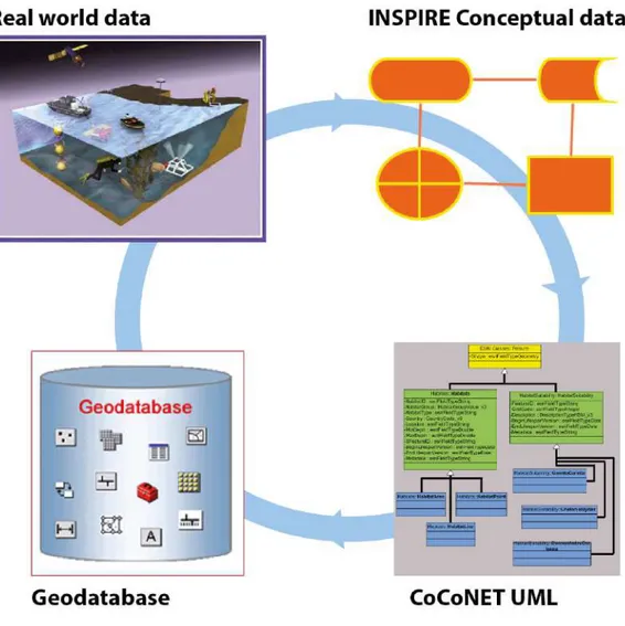
From real world to Geodatabase Architecture
The data collected in CoCoNet come from a great number of sources and span from physical oceanography to chemical oceanography, geology, biology, ecology, socio-economy and law. To overcome data fragmentation, and to integrate knowledge and compare data and products in a holistic view, the CoCoNet project designed a digital
architecture of 11 geodatabases following a
specific data flow. The design of conceptual data
models (coming from INSPIRE (Infrastructure
for Spatial Information in Europe) themes and properly adapted for CoCoNet objectives) was the starting point, then we created a logical Unified Modeling Language (UML) structure and finally physical repositories for data storing (Figure 1). The geodatabase architecture is the core of the system and is a powerful tool to homogenize the incoming data and provide means of communica-tion across different fields to reach the scopes of the project. The 11 geodatabases are integrated
in a WebGIS platform, as visible layers (Figure
2) accessible by partners and public at the follow-ing address: http://coconetgis.ismar.cnr.it/ . The WebGIS provides easy tools for data visualization, retrieving through advanced search, downloading and printing. The integrated Geodatabase, thought the WebGIS system, represents the linking tool for
all partners, regions and thematic research involv-ing the entire consortium in topics such as data provision and integration, GIS products, GIS inter-pretation, data archiving and data exchange.
Habitats in MPA networks
Information on the distribution of species and
habitats, and on whether and how different
anthropogenic drivers interact is central in ecological research (Fraschetti et al., 2008). Habitats are often good surrogates for species diversity: the greater the number of habitats in an area, the greater the number of species found there (Thrush et al., 2006). The conservation
of marine habitats may serve as a practicable surrogate for conserving scales of diversity
that include species and ecosystems. The value of
habitats and environmental factors as potential surrogates is largely unknown (Ward et al., 1999). In marine systems, maps are either used directly as a surrogate for diversity or combined with environmental data to model patterns of species distributions. Habitat mapping is fundamental for the identification of hot spots of habitat diversity.
Maps permit detection of changes in habitat cover,
and allow boundary demarcation of multiple-use zoning schemes. Large-scale maps visualise the spatial distribution of habitats, thus aiding the planning of networks of MPAs and allowing to monitor the degree of habitat fragmentation (Martin et al., 2014).
The European Nature Information System (EUNIS) catalogues European habitats, marine ones included, so as to meet the needs of conservation programmes. EUNIS stems from a UK perspective and does not cover the features
of Southern European Seas properly. For the Mediterranean Sea, the Habitats Directive, the Protocol for Specially Protected Areas and
Biodiversity in the Mediterranean (SPABM)
of the Barcelona Convention, and the Bern
Convention require cataloguing of marine
habitats. Mediterranean habitats as defined by UNEP/MAP were inserted into the EUNIS system based on their biological characteristics with respect to a specific EUNIS template (depth zone, substrate type, energy, characteristic and accompanying species etc.). However, several
structural caveats and discrepancies are observed in the way Mediterranean and Black Sea marine communities are classified in the EUNIS system. In addition to the above
named schemes, and others derived from them, independently developed local schemes are used in particular regions or countries. This calls for
data integration throughout the Mediterranean
and the Black Sea regions, since, at present, the application of EU standards is difficult in both basins. Habitat features are poorly defined and
biased towards benthos, determining grouping
of habitats that do not represent real distribution patterns. In addition, the plant component tends to be over-represented, reflecting a tendency to treat marine habitats as terrestrial ones, with the conceptual tools of phytosociology, while neglecting groups (e.g. invertebrates) and habitats (deep sea and, above all, the water
column) that are of fundamental structural and/or functional importance. It is urgent to standardise the classification of Mediterranean
and Black Sea habitats and to develop a scheme
that is applicable throughout the regions,
before more countries undertake further extensive habitat mapping that will exacerbate problems of integration. CoCoNet evidenced the bias, limits, gaps and pressures hindering the possibility of having a habitat classification scheme that represents the Mediterranean and Black Seas. Current classification schemes can be improved so as to better represent the complexity of ecological systems.
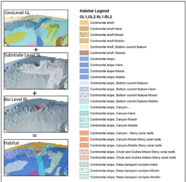
The CoCoNet Habitat Mapping Scheme
CoCoNet attempts to establish an integrated approach on the definition of habitats. This scheme combines multi-scale geological and
biological data (Figure 3), organized into three levels (Geomorphological, Substrate and
Biological), divided into several hierarchical
sublevels. The Habitat layer is the sum of these levels leading to maps with several possibilities of level combination.
An organized system, such as the “CoCoNet Habitat Mapping scheme”, is crucial for correct data management, since it allows to store, visualize, query and elaborate data to produce customized maps in an easy and efficient way. Moreover the use of the CoCoNet classification scheme gives to the system a multidisciplinary and multi-scale trait, essential for habitat mapping.
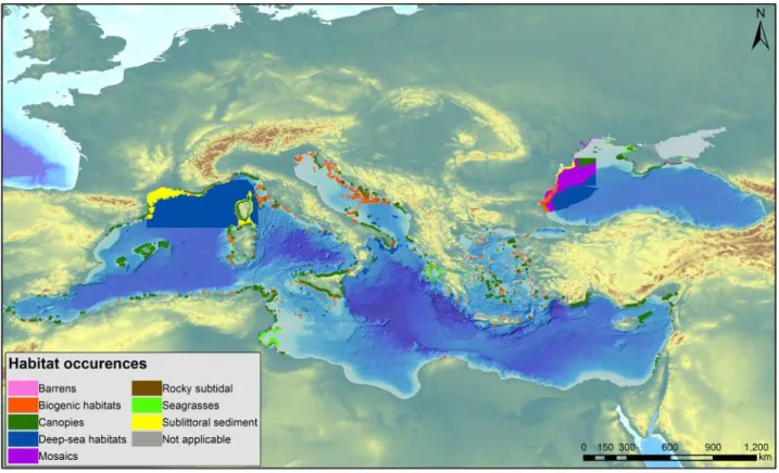
Habitat distributions: the baselines for
conservation planning
CoCoNet combined already existent GIS information and collected additional data about habitat occurrence across the Mediterranean and the Black Seas, homogenizing information following a properly designed standard architecture. This effort set the scene to improve spatial prioritization in the Mediterranean and the Black Seas starting from biogenic habitats (e.g. coralligenous formations and maërl), seagrasses (e.g. Posidonia oceanica), macroalgal canopies (e.g.
Cystoseira spp., Phyllophora crispa) and barrens
that are considered of critical importance for the two basins. This activity allowed substantial improvement of basic habitat information, reaching up to about the 40% of the two basins. The information is still very uneven but, after the CoCoNet project, it is clearly evident that there are stretches of coast such as Morocco and Tunisia with a surprising data availability and willingness to share data (Figure 4). Despite the efforts, the deep sea still largely lacks GIS information.
Taken as a whole, this information is critical to MPA selection with algorithms elaborated for systematic MPA design and especially suited for the design of MPA systems rather than constructing single MPAs: ecological concepts such as complementarity,
comprehensiveness and representativeness, adequacy and self-sustainability relay on
adequate knowledge about habitat distribution and extent, together with their structure (physical organisation, habitat patches) and function (ecological and evolutionary processes). The effort carried out in the project on increasing the knowledge on habitat distribution is also critical
for informing real applications of Maritime Spatial Planning (MSP), to avoid cumulative impacts on marine ecosystems, user conflicts, and to create synergies between maritime activities promoting the blue economy. MSP visualizes conflicts and compatibilities among human uses. The mapping of habitats and ecosystems, and of the human activities affecting them, identifies where conflicts are or will be located, finding alternative solutions for the distribution of human uses.
Recommendations concerning habitats
Habitats are good surrogates of biodiversity, pending a sufficient knowledge about how to protect and manage species, biological communities and ecosystems. The Habitats Directive covers a
restricted list of benthic habitats and a short list of charismatic species. The descriptors of GES call for a more comprehensive knowledge of marine systems. These recommendations are directed mainly to EU and national policy makers. The scientific community is involved in the process of knowledge building.
· Fully represent Mediterranean and the Black Sea habitats in EU Directives. The nine marine
habitats in the Habitats Directive do not rep-resent the full diversity of marine habitats and make it difficult to enforce protection through the Natura 2000 system that, in the Mediterranean Sea, at present covers mostly Posidonia meadows.
· Extend the habitat concept also to the water
Figure 3. The CoCoNet Habitat Mapping Scheme. The Biological level is organized according to a detailed list of habitat types (CoCoNet product)
compiled a full list of Mediterranean and Black Sea Habitats to provide a conceptual tool for the planning of habitat mapping, leading to protection and conservation.
· Improve the knowledge of the distribution of marine habitats to reach the quality attained
for terrestrial systems (i.e. Corine land cover) and assemble an all-species inventory for each habitat (master list). This will link species lists to habitat
types, allowing the assessment of biodiversity expression by comparison of the actual list of species recorded during a sampling campaign with the master list (the cumulative inventory of species found in that habitat). Master lists can be obtained by matching the European Register of Marine
Species (ERMS: http://marbef.org/data/erms.
php) with the habitats list. Each habitat, in this way, will be defined by a list of species (those recorded from that particular habitat). The suite of species that have been found in each habitat makes up the master list defining the potential biodiversity of that habitat. Some species are typical of a particular habitat (e.g. the species living only on the leaves of Posidonia) others occur in a suite of habitats.
The assessment of the biodiversity at each habitat is realized by matching what is found during a sampling session against the master list. The value of the assessment varies between 1 (all species of the master list have been found) and 0 (no species are found: dead zone) (Boero and Bonsdorff, 2007). MPAs are the first places where this exercise might be carried out.
· Base the institution of MPAs on fine-scale column. The exclusively benthic perspective
of the Habitats Directive is not coherent with the principles of ecosystem functioning. The concept of CEFs represents a holistic approach to environmental management, integrating the sea bottom with the water column. Open waters, in fact, are not homogeneous and pelagic habitats are to be identified and framed not only in space but also in time. Crucial phenomena (e.g. plankton blooms) take place in pulses and are the main drivers of ecosystem functioning.
· Upgrade the list of marine habitats and adapt
it to the concept of CEFs. CoCoNet developed a
hierarchical approach to habitat definition and
Figure 4. Distribution of biogenic habitats (e.g. coralligenous formations and maërl), seagrasses (e.g. Posidonia
oceanica), macroalgal canopies (e.g. Cystoseira spp., Phyllophora crispa), barrens, deep sea habitats, rocky subtidal,
knowledge of habitat distribution. This requires
the mapping of CEFs, so as to cover both the sea bottom and the water column, and the relationships between them. The mapping must be not only structural (what is where) but also functional (what is happening at specific places: e.g. phyto- and zooplankton blooms, spawning, nursery and feeding volumes for fish).
· Identify priority areas using adequate tools (e.g. MARXAN) for a refined selection of biodiversity hot spots. Use the conclusions reached by CoCoNet to inform a process of Maritime Spatial Planning (MSP) across the Mediterranean and the Black Seas, considering activities that are expected to increase in the future (e.g. aquaculture, maritime traffic, seabed mining). This will provide a solid scientific basis for planning the distribution of human activities in the seas.
· Evaluate ecosystem goods and services linked to habitats and ecosystems. In marine systems,
we still exploit natural populations (with fisheries) whereas this is not possible on land anymore, where we obtain resources almost exclusively from agriculture. These natural capitals must be properly evaluated and managed. Furthermore, natural systems provide services that range from CO2 sequestration to O2 production, climate mitigation, cultural inspiration, tourist attraction, etc. The value of the natural capital is extremely large and allows for our survival.
· Incorporate dynamic aspects (connectivity,
tro-phic interactions, spread of non indigenous species (NIS), and climate change) into spatial prioritization tools. Natural systems evolve, i.e. change. Ecology is a historical discipline (Natural History) and conser-vation cannot expect to just conserve the status quo. It is of paramount importance, however, to distin-guish between natural change and human-induced change.
Identifying and Mapping Environmental Threats
Knowing the location and impacts of human activities on marine ecosystems, and understanding the consequences of multiple human pressures on marine systems is crucial to develop spatial plans based on the analysis of management alternatives. In the Mediterranean and the Black Seas, threats
on species, habitats and ecosystems have been identified at basin and regional-scales (Coll et al., 2011; Micheli et al., 2013a). These analyses are of critical importance to move beyond the traditional single-threat approach, identifying key threats to different components of biodiversity and allowing site prioritization for different uses. However, these maps are not accurate enough to be applicable in strategies for local scale conservation and management, and to assess actual local impacts: more detailed, regional analyses are needed, as CoCoNet undertook in the two Pilot Areas (Figures 5, 6).
In addition, these studies on the effects of cumulative impacts on marine systems are largely based on expert knowledge, since costs and logistics often impair experiments at large spatial and temporal scales. Expert- or literature-based techniques have a limited potential to detect and understand the complex interactions that may exist among pressures (e.g., synergisms or antagonisms): real
data are needed. The effects are spatially variable
and site-specific, making it difficult to extrapolate general rules covering vast spatial scales. Quantitative assessments of the effects of different human-driven stressors among and within habitats are critical for understanding and predicting the cumulative impacts at a regional scale. Cross-habitats assessment is essential to adapt and respond to threats to marine environments.
Bioinvasions and MPA Networks
Intensification of anthropogenic activities, coupled with growth of littoral resident and transient recreational populations, are driving unprecedented changes in the Mediterranean Sea (EEA, 2015). Symptoms of complex and fundamental alterations to the sea’s ecosystems proliferate. Invasive alien species (IAS) of warm water affinity are on the increase, affecting the functioning of marine ecosystems, causing deep concern to scientists, legislators and managers (Williams & Grosholz, 2008; Ojaveer et al., 2014). The number of introductions into the Mediterranean Sea is far higher than in any other sea (Galil et al., 2014). The greatest increase was recorded in the 1990s and the 2000s, a period in which the most severe thermal anomalies occurred (Rivetti et al., 2014), as well as the expansion of shipping, mariculture and size of the Suez Canal.
The number of multicellular non-indigenous species (NIS) is 726, of these, 450 are’Erythraean’ NIS introduced into the sea through the Suez Canal: the number of NIS is substantially greater in the eastern than in the western Mediterranean (Figure 7). This is only a partial inventory, as our ignorance of the marine biota leads to massive underreporting and understatement of bioinvasions.
MPAs were established to conserve the diversity of native species in their habitats, with an ecosystem-based approach to conservation, providing protection to habitats, biodiversity and ecosystem services, and insurance against environmental or
management uncertainty.
Contrary to these expectations, Erythraean NIS are frequently the most common species encountered in the MPAs in the Eastern Mediterranean, where the invasion has already altered the structure and function of ecosystems in a pervasive fashion. Currently, rocky reef fish assemblages in Eastern Mediterranean MPAs were observed to be prone to the Erythraean invasion through the Suez Canal (Guidetti et al., 2014), and the same was observed for opisthobranch NIS (Yokes et al., 2012). Along the Lebanese coast, surveys aimed at identifying locations for MPAs highlighted the prevalence of
Figure 5. Spatial distribution of human activities in the Mediterranean Sea. Top: main pressures at regional scale (Pilot Area); bottom: scale up with a focus on touristic pressure, artisanal fishery, port, discharges, Posidonia loss on a specific area of Apulia (Italy)
Figure 6. Spatial distribution of human activities in the Black Sea. Top: main pressures at regional scale (Pilot Area); bottom: scale up with a focus on aquaculture, fishery, ports, discharges, water courses, utilities and service lines, on a specific area of Bulgaria
NIS at all sites, with 31% and 21% respectively of the recorded mollusc and fish species identified as Erythraean NIS (RAC/SPA - UNEP/MAP, 2014). The Akhziv-Rosh HaNiqra nature reserve, the largest and best managed of the marine reserves along the Mediterranean coast of Israel, harbours an exceptionally high number of Erythraean NIS. Temperature increases are probably conducive to the extension of the invasion also in the Western Basin, where many of these species already thrive, even though some can undergo a strong reduction of their populations. Montefalcone et al. (2015), for instance, showed that the abundances of the so-called killer alga Caulerpa taxifolia declined in recent years, though the equally invasive C.
cylindracea became dominant at many places, with
unexpected impacts on the quality of commercial fish (De Pascali et al., 2015). The grazing of the schooling Western Indian Ocean rabbitfish Siganus
rivulatus and S. luridus replaced algal forests with
wide areas of bare substratum, results in a dramatic decline in biogenic habitat complexity, biodiversity and biomass (Vergés et al., 2014). These grazers are rapidly expanding to the Western Mediterranean. The Mediterranean network of MPA managers
(MedPAN) recognized that “Marine Protected Areas in the Mediterranean don’t escape of this general trend [of bioinvasion] and most of them have been affected by the introduction of alien invasive species for a long time, threatening marine biodiversity…. MPAs across the MedPAN Network face common challenges, among them, the lack of awareness and understanding of the impacts of invasive species, the scarcity of information on best practices for management as well as the insufficient baseline information, guidelines and trained local staff to identify and gather knowledge on species introductions and impacts… At a regional level… there is still a weak networking, coordination and collaboration on this issue” (IUCN, 2012). MedPAN focuses its attention on the internal governance, strategies, and management effectiveness of MPAs. Otero et al. (2013) highlight the risk posed by NIS to MPAs, introduce management strategy and actions, provide a priority list of invasive species with the greatest potential impact, present NIS monitoring and data recording protocols and offer well illustrated fact sheets for priority Mediterranean IAS. Due to a lack of monitoring, detection of NIS in MPAs may lag introduction by years, if not decades,
Figure 7. NIS pressure. The number of marine NIS recorded in some Mediterranean countries. In red, NIS considered to have been introduced through the Suez Canal; in grey, NIS considered to have been introduced by other vectors - mainly shipping and culture (after Galil et al., 2015)
and their numbers, as reported by MPA managers, are likely to be grossly underestimated (Abdulla et al., 2008).
Considering the highly connected nature of the sea, a MPA will not be free of NIS unless embedded in an integrated ecosystem management regime, as well as a network of MPAs. The European Union’s ecosystem-based ‘Marine Strategy Framework Directive’ (MSFD) that aims to protect biodiversity in European marine regions acknowledges that NIS represent one of the main threats to marine biodiversity and related ecosystem services, and places the absence of NIS impacts as the second descriptor of ‘Good Environmental Status: “Non
Indigenous Species do not adversely alter the ecosystem”. The success of the MSFD is key
to achieving the long-term objectives of MPAs. However, management in the Mediterranean Sea is hampered by political, economic and societal fragmentation: only 8 of the riparian countries are EU Member States. The option of implementing European environmental policies in those states alone may seem expedient but piecemeal protection is futile. The crucial element of an effective strategy for slowing the influx of marine NIS into MPAs in the Mediterranean Sea is policy coordination with the Regional Sea Convention (‘Barcelona Convention’) to ensure consistency in legal rules, standards and institutional structures. Research may ascertain that healthy ecosystems, as those attaining GES, improve both the resistance and the resilience of networks of MPAs also to bioinvasions, but unquestionably prevention remains the best management option. No MPA, for instance, can stop the blooms of the non indigenous ctenophore Mnemiopsis leyidi, once they are formed. Mnemiopsis devastated Black Sea ecosystems, and was possibly introduced in ballast waters. The containment of Mnemiopsis depends primarily on ballast water management. The same is true for all NIS: prevention is the only practical option. Networks of MPAs, however, might play a role in both the management and the study of NIS. NIS should be considered in designing the placement and management of networks of MPAs.
Recommendations concerning threats and
bioinvasions
The concept of protection implies that there are threats to the to-be-protected object. Marine environments are subjected to a varied array of
threats, categorized in the Descriptors of GES in the MSFD. The objective of MPA networks is to identify threats and remove them, whenever possible.
The stakeholders of this section are mainly the managers of MPAs and MPA networks, the NGOs that focus on environmental protection, local, regional and international policy makers that should implement policies that aim at removing the threats of environmental integrity, the tourist and the fisheries sectors that take advantage from good environmental status to gain their income. The following actions are recommended:
· Improve knowledge of the distribution and
intensity of threats (e.g. fishery, bioinvasions,
marine litter) to reduce uncertainties on their effects. The definition of GES comprises 10 descriptors (in addition to the first one: biodiversity) that cover the array of stressors on both biodiversity and ecosystem functioning.
· Base large-scale approaches on fine-scale spatial data and develop shared methodologies
and strategies for the management of potential impacts and consequent changes. The extrapolation of few small-scale studies or of low-resolution large-scale assessments often bias large-scale pictures, representing threats inadequately. Fine-scale data, from intensive observation and monitoring strategies, reliably account for the state of the environment.
· Link threat mapping with specific actions
identified on the base of successful cases of recovery to make better conservation/ management decisions. Once threats are identified, it is important to implement measures aimed at their reduction, leading to environmental restoration. These actions must be taken into account in association with the information about stressor distribution, since remedies that were effective at one location might also be effective at other places. The share of this information is crucial.
· Prioritise and monitor areas highly exposed
to present/future human pressures, including the consideration of critically dynamic changes (e.g. hot spots of thermal anomalies, invasions by NIS). The high exposure to threats should be followed by mitigation and restoration actions, through
proper management of ecologically coherent marine spaces (e.g. MPA networks).
· Develop novel tools and strategies to move
beyond the traditional single-threat approach to assess the response of ecosystems to multiple stressors (present and future), identifying key threats to different components of biodiversity and allowing site prioritization for different uses. The MSFD requires, with GES, that neither biodiversity nor ecosystem functioning are altered by human action. Before, human action was requested to remain under presumed thresholds, while considering threats in separation from each other. When acting in synergy, however, stressors can have effects that are not the simple sum of the effects of each stressor.
· Evaluate early warning indicators to identify
approaching changes in marine biodiversity and ecosystem functioning, supported by biodiversi-ty monitoring methods and the quantification of ecological thresholds. The compound effects of regional and global stressors erode the resilience (the ability of a system to withstand to and to re-cover from perturbations) of marine systems may cause transitions towards undesired states. The knowledge of “natural history” provides insight in the way ecosystems function. Expert opinions can interpret environmental data and early worning indicators can reveal signs that inform us about the possible onset of events leading to regime shifts.
· New MPAs should be located away from the regional hubs of vectors and pathways (i.e. ports,
marinas, fish and shellfish farming, and from the major pathway of invasion in the Mediterranean - the Suez Canal)
· Use MPAs as “sensors” of NIS, with continuous monitoring, especially in MPAs with high NIS
load, near invasion hubs; conduct risk assessment of secondary spread; analyse cost-effective options for long term control of NIS populations.
All-species inventories have not been carried
out at any marine location: it is advisable that the biodiversity of MPAs and of their networks is continuously assessed through focused programmes involving biodiversity specialists. This will allow the early detection of NIS and, even more importantly, will identify inconspicuous NIS that are not immediately perceived by casual
observation. Inconspicuous species, in fact, can have great impacts on biodiversity and ecosystem functioning.
· Consider changes to protection status (e.g.
allowing for eradication measures) if NIS popula-tions adversely affect native natural diversity and risk secondary spread. The eradication of NIS re-quires destruction of living beings. There might be an apparent conflict between generalized protec-tion and the eradicaprotec-tion of NIS populaprotec-tions.
· Enforce the precautionary principle until
science-validated results are available. Focus basin-wide management on prevention of new incursions of invasion vectors and pathways and, where practicable, on beachhead and hub sites to minimize secondary spread.
· Inform stakeholders of the scope and status of threats (e.g. bioinvasions) in MPAs. Discuss
management options and commitment of resources for threat control, and possible changes to protection status.
3.2 STEP 2: define spatially explicit
management and conservation units
Connectivity underlies marine conservation
These guidelines emphasise the crucial importance of Connectivity as the fundamental principle for building coherent networks of MPAs. The demographic linking of local different populations through the dispersal of individuals (also called
propagules) as larvae, juveniles, adults or
asexual dispersive stages (Sale et al., 2005) is key to metapopulation persistence (Botsford et al., 2009). Thus, the existence and the maintenance of connectivity between MPAs are critical to the long-term success of MPA networks, which essentially operate as complexes of metapopulations (Roberts et al., 2003). Ensuring connection between MPAs will increase in importance as climate change increasingly impacts the future of marine ecosystems (Munday et al., 2009).
Since MPAs are mainly coastal (with the exception, in the Mediterranean Sea, of the Pelagos Sanctuary), connectivity has been mainly been regarded as larval dispersal, disregarding the connectivity
roles of asexual propagules, juveniles, adults and some ontogenetic migrations, or rafting (Figure 8). To understand the effects of dispersal on population replenishment and resilience, it is important to differentiate between (1) “sustaining” dispersal: ecologically/ demographically important in maintaining or increasing a local population (Halpern and Warner, 2002) and (2) “seeding” dispersal: evolutionarily important in maintaining gene flow and decreasing the long-term probability of local extinction. Sustaining dispersal occurs over
small spatial scales whereas seeding dispersal
occurs over large spatial scales. Small populations produce fewer propagules than large populations. As a result, as population size (or MPA area) decreases, the distance over which it can provide both sustaining and seeding dispersal decreases (Figure 9).
Ensuring that MPAs in a network are connected to one another via propagule dispersal is, all else being equal, largely a function of spacing
between MPAs and of the biology of the species forming the species assemblages inhabiting them. Since small populations/MPAs produce fewer propagules than large populations/MPAs, the spacing between small MPAs needs to be smaller to ensure connectivity between them. This can be achieved by decreasing the distance between MPAs, either by increasing the size of individual MPAs (leading to overlaps) or by adding more
MPAs to the network (Figure 10). Many MPAs in
the Mediterranean Sea, however, protect unique places that are not homogeneously distributed, so these principles of how to arrange MPAs in space are not always applicable, unless connectivity is
enhanced through proper management.
Determination of connectivity
Connectivity is widely recognized as an important process in sustaining biodiversity, but until now we have had to use simple rules of thumb about spacing, developed largely without empirical evidence, to account for connectivity in MPA network designs (McCook et al., 2009). Historically, it was assumed that oceanographic conditions (currents and tides) played a dominant role in determining how far and to where propagules disperse.
While oceanography clearly does play a role, the last several decades of research on pre and
post-settlement processes (Fraschetti et al., 2003)
have demonstrated that propagules are not all passive particles, but instead display a range of sophisticated behavioural, sensory, swimming and floating abilities that allow them to influence species dispersal (Dixson et al., 2008; Dixson et al., 2011). Indeed, the occurrence of self-recruitment in species with planktonic larval durations of ~30 days demonstrates this fact; models that assume passive transport of propagules by currents and tides predict little or no self-recruitment, and certainly not at the levels observed in recent studies. As a result, oceanographic conditions
are unlikely to fully explain dispersal patterns,
but instead interact with a host of ecological, environmental and behavioural factors to
Figure 9. Hypothetical dispersal kernels for three populations (A, B and C) that differ in size. The horizontal line differentiates between ecologically-important sustaining dispersal and evolutionarily-important seeding dispersal. As population size decreases (A→C), the distance over which it provides sustaining dispersal decreases (z→x), and the distance over which seeding dispersal occurs may decrease as well. Population C is too small to provide any sustaining dispersal. After
Steneck et al. (2009) Figure 10. Simplified conceptual model illustrating the effect of MPA size and spacing on connectivity in a MPA network. In each diagram, numbers (1-3) designate the centre of the MPA, white space the distance over which ecologically-important “sustaining” dispersal occurs, grey space the distance over which evolutionarily-important “seeding” dispersal occurs. A. Spacing between two relatively large MPAs appropriate to insure sustaining dispersal between them. Note that the area of overlap of the seeding dispersal kernels for the two MPAs may or may not be sustaining. B. 50% smaller MPAs than in A but the same distance apart. MPA populations are smaller, producing fewer propagules, thereby decreasing the spatial scale of dispersal resulting in no connectivity between them. Re-establishing connectivity between small MPAs can be accomplished by decreasing the distance between them or C the addition of a third small MPA to the network. After Steneck et al. (2009)
determine the processes that realize connectivity. Connectivity measures the possibility of propagule
exchange (i.e. the bodies with which species propagate themselves, ranging from larvae, to adults, to fragments) among different populations
across a defined space. It can be measured from single species to entire communities. The physical features of the medium (defined by oceanography) influence each species in different fashions. The networks should comprise spaces that are highly connected (i.e. in which connectivity is high for a significant number of species).
In CoCoNet, considering the works developed in the last several decades, we investigated a wide variety of methods to understand connectivity, underscoring the importance of such information for achieving sustainable fisheries and conserving biodiversity. Four determinants were selected for detailed investigations to evaluate the degree of connectivity relevant for networks as described below.
1. Currents. The pattern of currents is the first and most important motor of connectivity but also the most variable and complex to predict. Currents can vary, according to seasons and other pluriannual fluctuations; they involve upwellings, fronts, downwellings, gyres and eddies, all contributing to connect or isolate regions, but characterized by some temporal instability. If currents would explain everything, biodiversity should be equally
distributed, in all its facets, according to current
patterns. The study of nature tells us that it is not so and that there is a high degree of heterogeneity in the way connectivity takes place.
2. Propagules. The presence of propagules in the water column is a necessary condition for transport and further potential successful connectivity.
Propagules are not inert particles, passively
transported by currents.
3. Beta Diversity. The share of species among various habitats of the same kind is informative about the degree of connection across habitats. If the same habitat type has many species in
common (say 80%) at two separate locations, there
is reasonable indication that the two locations, and their habitats, are highly connected.
4. Genetic diversity. The higher the similarities at genetic level, the higher the connections among the populations of investigated species at various investigated locations; and in that sense genetic differentiation is an indirect outcome of barriers to connectivity.
Oceanography/propagules are components in a process-oriented life-history approach assessing
potential connectivity, connectivity variability and the sensitivity of connectivity to e.g. climate changes and direct anthropogenic impacts. Beta
diversity/genetics are pattern-oriented, being
indirect and direct measures of past and realized
connectivity, respectively. Together, they form an integrated scientific suite for connectivity assessment. The following procedures describe the CoCoNet approach to the evaluation of the four descriptors of connectivity.
Oceanography
Currents are the main driver of connectivity: the dynamics of the transport of passive particles through the movement of water (currents) is the starting point of connectivity evaluation (the null hypothesis that should lead to a homogeneous distribution of species according to current patterns). A detailed and dynamic assessment
of mesoscale currents is a prerequisite for any network design. Species reproduce in
specific seasons, and currents are often subjected to seasonal changes. Matches and mismatches of physical and biological phenomena within a seasonal framework can explain the observed patterns of biodiversity distribution and the processes determining them.
However, it is important to consider life
trait-based variables in simulations with passive particles. Averages of trait-based simulations
from/to specific habitats do not correspond to the simulation of average water particles. If currents were solely responsible for connectivity, all the species in a given circulation pattern would disperse in an identical way, resulting in identical distributions for all species. This is not what we observe, even when habitat distribution is conducive to the presence of some species (i.e. the same habitat type, at different locations, instead of having the same set of species, can host different species assemblages) so species respond in different ways to the distribution potential of current regimes. The realized distribution of species across vast marine spaces, through current patterns, depends on the timing of reproductive processes, coupled with propagule features and pre- and post-settlement biotic interactions. It is also necessary to specifically address coast/
offshore/deep sea exchange processes. These
are often disregarded due to the complexity of coastal dynamics, where turbulence plays a major role. General current patterns (e.g. the Gibraltar Current, the Intermediate Levantine Current, the cascading phenomena due to the influence of the cold engines) are well known and modelled. These
Figure 11. A connectivity-based regionalisation of the Mediterranean Sea (Berline et al., 2014 – CoCoNet work). Each boundary is colored and numbered according to the cut-off distance obtained on the dendrogram (from blue – high distance- to green low distance). Each region is identified by a letter from A to V. Most boundaries parallel to permanent currents. Some boundaries parallel to salinity/tracer fronts. Consistent with current expert knowledge of species biogeography
circulations are mostly typical of offshore areas. The irregularities of the coasts (e.g. promontories, capes, inlets, straits, etc.) and of the sea bottom (e.g. canyons, sea mounts, trenches, etc.) determine local situations in which the general circulation patterns might be much altered. These alterations occur at the scale of organisms and are of extreme ecological importance. Canyons, for instance, connect coastal systems with the deep sea and cause intensive production rates. Capes and promontories, moreover, often determine eddies and gyres, connecting coastal with offshore systems. These small scale and mesoscale phenomena occur at ecologically meaningful scales, they are highly variable in time and need to be properly described, understood and modelled, leading to couple physical and bio-ecological processes.
In addition, extreme events (storms, sudden temperature changes, etc.) must be considered since they may change connectivity if they either match or mismatch propagule availability. Irregular and extreme phenomena can connect areas that are usually separated by “normal” current regimes. If the timing of propagule production
matches with these events, species can disperse in apparent discordance with prevailing water movement. Storms can lead to high fragmentation rates, leading to dispersal of asexual propagules that can travel for very long distances, especially if settled on natural (e.g. drifting algae) or artificial (e.g. floating debris) rafts.
An example of a possible ecological partitioning of the Mediterranean Sea is illustrated in Figure 11. The figure shows a snapshot of currents in the Mediterranean Sea (model output from the joint MIT/JPL project: Estimating the Circulation and Climate of the Ocean, Phase II or ECCO2 (http:// ecco2.org/).
Based on oceanographic data (Figure 12) and new modelling involving biological features we end up proposing five coastline units for the Black Sea (Figure 13).
Propagules
The pathways, vectors and impacts of propagule
pressure of a vast array of species are
Figure 13. Clustering trend with pelagic phase of 10, 30, 50, 70, 90 days. Colors indicate the extent of coastline habitat clusters (CoCoNet work). For the Black Sea we found the eco-regionalization to be species (trait) dependent, and the figure below is an example. However, our meta-analysis indicated that meso-scale oceanographic features (in our case gyres) were sculpting eco-regions