UNIVERSITÀ DEGLI STUDI DI SASSARI
SCUOLA DI DOTTORATO DI RICERCA
Scienze e Biotecnologie
dei Sistemi Agrari e Forestali
e delle Produzioni Alimentari
Indirizzo: Agrometeorologia ed Ecofisiologia dei Sistemi Agrari e Forestali
Ciclo XXVI
Wildland Urban Interface:
Mapping and Wildfire Risk Assessment
Dr. Casula Franco
Direttore della Scuola
Prof. Pusino Alba
Referente di Indirizzo
Prof. Spano Donatella
Docente Guida
Dr. Sirca Costantino
Ringraziamenti
Non spesso mi è capitato, quanto in occasione della realizzazione del presente lavoro di tesi, che la doverosità del ringraziamento si accompagnasse tanto armonicamente alla piacevolezza della gratitudine.
Probabilmente questa consonanza di sentimenti ha radice nel fatto che il lavoro di tesi che ho svolto è stato possibile grazie alla collaborazione e l’aiuto di molte persone la cui competenza professionale e scientifica si accompagna, altrettanto armonicamente, a grandi qualità umane che hanno reso l’interazione tanto utile quanto gratificante.
Ringrazio il Corpo Forestale e di Vigilanza Ambientale della Regione Autonoma della Sardegna al quale appartengo, che mi ha concesso un periodo di aspettativa per Dottorato di Ricerca, ed il dipartimento DipNeT dell’Università di Sassari presso il quale sono stato seguito e consigliato durante lo svolgimento. In particolare ringrazio la Professoressa Donatella Spano ed il Dottor Costantino Sirca che, lasciandomi piena autonomia nella ricerca, hanno comunque guidato il mio lavoro, la Dottoressa Valentina Bacciu per i preziosi confronti, il Dottor Michele Salis non solo per i numerosi consigli ma anche per i concreti contributi inerenti la simulazione degli incendi.
Un sentito ringraziamento va all’amica Sweta Gupta, per essersi tanto profusa nel correggere il mio inglese.
Durante la tesi ho avuto la fortuna di svolgere due periodi all’estero che sono stati fondamentali per lo svolgimento del lavoro e che mi hanno dato la possibilità non solo di approfondire lo studio, ma anche di arricchirmi culturalmente e
umanamente.
Ringrazio dunque la direttrice Dr. Marielle Jappiot e tutto il laboratorio EMAX dell’IRSTEA con sede ad Aix-en-Provence (Francia). In particolare sono grato al Dr. Christophe Bouillon che ha reso possibile e facilitato il mio stage ed ha seguito e guidato l’avanzamento del mio lavoro durante in mio soggiorno francese. Ringrazio il Professor Tim Brown non solo per avermi ospitato per il mio secondo stage nel Laboratorio di Scienze dell’Atmosfera che dirige presso il Desert Research Institute di Reno in Nevada (USA), ma anche per i suoi preziosi contributi
all’armonizzazione del lavoro di tesi tramite i numerosi consigli ed il costante confronto.
Dell’incontro con Christophe Bouillon e Tim Brown sono grato alla fortuna che ci ha messo un pizzico di suo.
ACKNOWLEDGEMENTS
Not so often it occurred to me what is happening now at the completion of my PhD thesis work: I feel that I ought to, but, at the same time, that I have the heartfelt pleasure to thank the remarkable people who contributed towards the realization of my research.
2 This harmony of my two feelings is probably based on the fact that these
people harmonize the scientific competency with profound human richness which makes the interaction with them intensely gratifying. I thank my Forest Service, the Corpo Forestale e di Vigilanza Ambientale of Regione Autonoma della Sardegna, for having granted me prolonged leave from work in order to pursue my PhD. I wish to thank the DipNeT of University of Sassari where I completed my research in the framework of the XXVI° PhD course. In particular, I would like to thank Professor Donatella Spano and Dr. Costantino Sirca for having guided my work and at the same time respected my autonomy in conducting the research, and Dr. Valentina Bacciu, for providing her expert inputs augmenting my knowledge on various topics. I would like to extend my gratitude to Dr. Michele Salis for his many remarkable guidelines and concrete contributions especially in the part of the thesis dealing with wildfire simulations. I wish to thank my friend Sweta Gupta for her efforts and significant contribution in editing my thesis and helping me with my English writing. During the course of my PhD program, I was very fortunate to spend two
training periods abroad. Not only has the experience of these trainings been fundamental for my thesis work but has also been a truly enriching life experience. I am, hence, grateful to the director Dr. Marielle Jappiot and to the entire laboratory EMAX - IRSTEA of Aix-en-Provence (France). I am heartily thankful to Dr. Christophe Bouillon who gave me the opportunity to spend my training period in IRSTEA and guided the development of my work during my sojourn in Aix-en-Provence. I am thankful to Professor Tim Brown for offering me the opportunity to spend my second training period in the Division of Atmospheric Sciences of the Desert Research Institute in Reno, Nevada (USA). His deep knowledge enlightened my points of view and his concrete contributions to my work enabled me to develop a deeper understanding of the subject. Interacting, working with, and getting to know some pleasant and ingenious
people like Christophe Bouillon and Tim Brown has been a profound rewarding experience whose importance for me will last for a lifetime.
Table of Contents
Abstract ... 5
PART 1: Introduction ... 9
Foreword ... 11
Defining Rural-Urban Interface ... 15
Part 2: Rural-Urban Interface Mapping ... 23
Foreword ... 23
Mapping methodologies – Generalities ... 25
Study areas ... 29
Materials and methods ... 33
Global Scale mapping ... 35
Local Scale mapping – Option 1 ... 39
Local Scale mapping – Option 2 ... 41
Results ... 45
Global Scale mapping ... 47
Local Scale mapping – Option 1 ... 59
Local Scale mapping – Option 2 ... 81
Dynamics in RUI – A diachronic analysis on a case study ... 91
Part 3: Wildfire Risk Assessment in Rural-Urban Interface ... 99
Foreword ... 99
Risk, Hazard, Danger, Intensity, Vulnerability – Definitions ... 101
Materials and Methods ... 110
Overlay Mapping methodology for wildfire risk assessment ... 112
Multicriteria methodology for wildfire risk assessment ... 119
Multisimulation methodology for wildfire risk assessment ... 135
Results ... 141
Overlay Mapping methodology for wildfire risk assessment ... 143
Multicriteria methodology for wildfire risk assessment ... 155
Multisimulation methodology for wildfire risk assessment ... 195
Conclusions and perspectives ... 209
Appendixes ... 215
4 Appendix B – Local Scale mapping methodology option 1. ... 221 Appendix C – Local Scale mapping methodology option 2 ... 227
References ... 229
Abstract
The Rural Urban Interfaces (RUI), are those areas in which vegetation and houses are in contact or intermingled. Vegetation constitutes the prerequisite for wildfire propagation and, given the high number of values exposed to wildfire and the fact that the highest ignition densities are recorded inside RUI, the worst consequences of wildfires usually occur in these environments. It is, hence, particularly important to map and to create models for wildfire risk assessment in RUI.
The work of the present thesis is organized into two parts:
- In the first one RUI are defined, mapped and classified into RUI typologies, and a characterization of the relation between RUI and fire regime is performed.
Three different operational definitions of RUI are used and in the study it is shown how RUI area largely depends on the adopted definition. Although the maps obtained using various methods differ in identifying portions of the territory as RUI, all methodologies consistently recognise that inside RUI the ignition density is higher and the burned areas are smaller than elsewhere.
A section of the study compares the different kinds of RUI demonstrating that not all RUI typologies imply similar complications for wildfire protection and in particular that the Isolated Housings are the most difficult to manage for preventing wildfire damage. A case study of diachronic mapping shows the utility of RUI classification for describing the evolution on time of RUI phenomenon.
- In the second part three models for wildfire risk assessment in RUI are presented. In particular, aside an application of a classical overlay mapping methodology taking into account the principal risk factors, other two methodologies are developed and applied: - Multicriteria approach: the model has been developed through the Analytic Hierarchy Process and optimized thanks to thirty interviews to experts. An application to a case study is also presented.
- Multisimulation approach: it is based on the use of wildfire simulator for quantifying house exposure in terms of wildfire probability and intensity and on the use of RUI maps for assessing the presence and vulnerability of values exposed to risk. The model has finally been applied to a case study.
The three risk models work at different scales, using different inputs; all of them are capable to produce risk maps showing the spatial distribution of risk and their results show to be consistent.
6 Extended Abstract
Wildfires, as part of the ecosystem functionality and as a natural phenomenon, have always participated in modelling the landscape. Nevertheless, they are considered a very important global issue because they can damage economic values and threaten human lives, often requiring professional intervention by civil protection.
In Mediterranean areas wildfires have a broad diffusion because of the particular hot and dry climate during summers and of the high population density. In this area wildfire regime is strongly influenced by human presence since the majority of ignitions are related to human activities (arson or negligent/inexperienced actions). In Europe, every year, an average of 60,000 wildfires occur, burning about 6,000 km2 (EEA, 2003; JRC, 2007), and the majority of them happens in Mediterranean countries.
Fire regimes are in constant evolution and a negative influence may be expected, due to climate changes (higher hydric deficits, higher temperatures) and to social changes.
The phenomenon of land abandonment is augmenting fuel continuity on the landscape and, at the same time, urban centres are expanding toward the countryside creating periurban residential neighbourhoods characterized by an intermingle of low-density housing and almost continuous fuels.
These wide areas where houses and vegetation co-exist are called either "Rural-Urban Interfaces (RUIs)" or "Wildland-Urban Interfaces (WUIs)".
The great number of houses located in vegetated contexts and hence exposed to wildfires constitutes a high-risk situation and, although RUI usually covers a small percentage of land, it is there that the highest rate of ignition points, the most severe damage and the worst problems of Civil Protection due to wildfires occur.
It is, then, especially important to have a particular focus on RUIs and to assess wildfire risk in these special areas.
Mapping out RUIs is the first step for creating appropriate methodologies for Wildfire RUI Risk
Assessment, that is the process by which the likelihood and magnitude of the occurrence of an
unwanted, adverse effect is estimated together with the likelihood of a possible damage for values exposed to it.
The aims of this thesis are to produce maps of the Interface and to develop and apply methodologies for wildfire risk assessment in RUIs.
The thesis work is organised into two main parts:
- the first one concerns RUI definitions and mapping;
- the second one deals with methodologies for wildfire risk assessment in RUI.
In the first part three mapping methodologies of RUI environments have been used. They are
available in the RUImap® tool that is a main product software of the European Project FUME (7th EC program). The thesis work has been carried out in the framework of FUME project and has contributed to the development of RUImap®, an easy-to-use software for automated RUI mapping, now protected by intellectual property right.
In RUImap®, a Global Scale and two Local Scale RUI mapping methodologies are available. They work at different scales, use different inputs and operational definitions of RUI and produce different kinds of RUI maps. The three methodologies not only identify the perimeter of RUI area but they also classify RUI according to three set of RUI typologies which have been created to better assess wildfire risk. Classification of RUI has been found to be much more useful than just the definition of its perimeter because it allows distinguishing between different kinds of RUI.
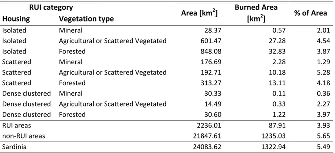
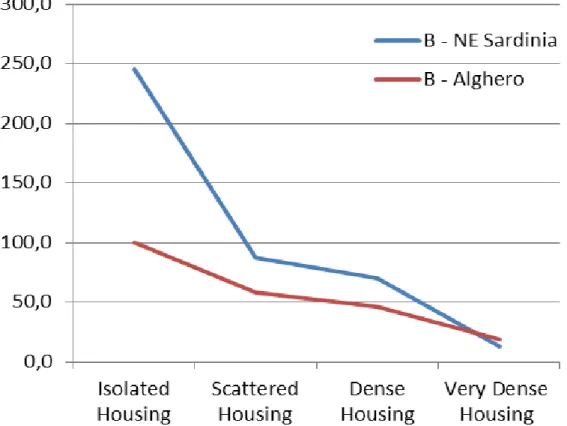
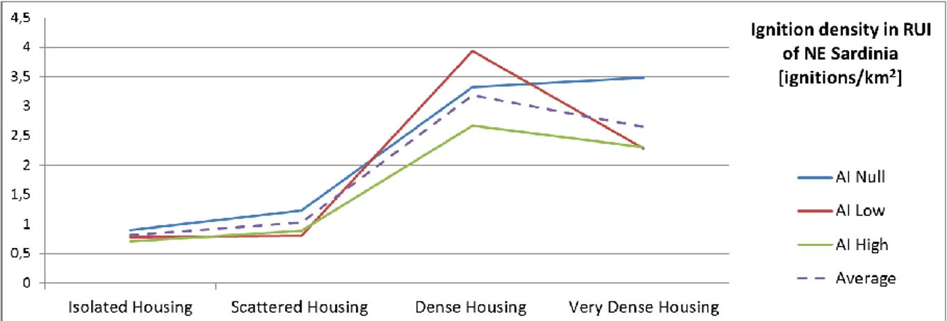
A section of the work studies the interaction RUI/fire regime, finding out that the distribution of ignitions and burned area vary not only between RUI and non-RUI areas but also when comparing the different RUI typologies: in particular, all the methodologies and all mapped study areas show higher ignition densities and lower percentage of burned area inside RUI than elsewhere and that ignition density grows and burned areas lessen in the RUI typologies of denser housing.
Another section of the study shows how the various RUI typologies are characterized by different surface to be brush-cleared for house safety, and hence by different economic effort to be sustained by the community and the house owners; in particular it is much more onerous to manage the houses located in Isolated Housing RUI typologies than the ones in Dense and Very Dense Housing RUI typologies.
A diachronic mapping for studying the RUI evolution over time has also been performed on a case study, finding out a general increase of RUI surfaces especially in disperse housing categories.
In the second part of the thesis two methodologies for wildfire risk assessment in RUI are
developed: a Multicriteria approach and a Multisimulation approach. They are applied along with a classical overlay mapping and a comparison between the three methodologies is also performed.
The risk definition we adopted takes into account on one side the hazard factors describing the source of risk (fire probability and intensity) and on the other the factors related to the values exposed to the source of risk (house distribution and vulnerability).
One of the risk models has been created using Multicriteria techniques and in particular the structure of the model has been developed through the Analytic Hierarchy Process and has been optimized thanks to thirty interviews to experts. The model has also been applied to a case study and a territorial map of wildfire risk in RUI has been produced.
In the Multisimulation approach the software Randig, capable to simulate the wildfire spatial propagation, has been used for assessing hazard on the territory and in particular the exposure to wildfire of houses located in RUI. Randig results have provided the simulated spatial distribution of Burn Probability and Flame Length and they have been found strictly consistent with real distribution of burned areas in RUI.
The Burn Probability and the Flame Length maps produced by Randig have been combined with the map produced by the Global Scale mapping methodology whose RUI typologies are able to distinguish among areas characterized by different densities of values exposed to risk (houses). RUI typologies located in forested areas have been considered more vulnerable than the ones located on disperse vegetation contexts. The RUI typologies report not only the housing density but also the context in which the houses are located and hence the Global Scale map has been used to assess both the presence of values exposed and their vulnerability. Having the four factors Burn Probability, Flame Length, Vulnerability, Values exposed, we have finally produced a map of wildfire risk in RUI.
The three risk models differs in the scale at which they work, in the inputs they need, in the complexity of their implementation, in the time they require to be applied, but all of them are capable to produce risk maps showing the spatial distribution of risk. The results can be judged consistent: in particular the overlay mapping methodology and multicriteria methodology show to be able to identify same areas as high risky ones, putting on evidence similar patterns in the risk maps. Their acuity in classifying the landscape is different and the multicriteria methodology which takes into account many more parameters and inputs looks to be the most accurate in creating wildfire risk maps of RUI.
Foreword
Wildfires are considered a very important global issue. They are a natural phenomenon and have always been part of the ecosystem, but being able to cause severe damage to people, their belongings, economic goods and activities and to the environment itself, they often become a critical problem, requiring professional intervention by civil protection. Fire is an important natural element that participate in landscape and ecosystems evolution, and if, on one side, in the dry and hot season it can cause severe damage, on the other, the controlled use of fire can be helpful in forestry as a tool to manage fuel charge and protect ecosystems and human values. Wildfires occur almost all over the world, except in the tropical desert areas and at the highest latitude (>70°) (Mack et al. 2011)i. They are more common in the inter-tropical latitudes and at medium latitudes, because in these areas, which are densely populated, there is a strong presence of vegetation (fuel of various types).
It is widely accepted that, almost all over the world, the main causes of wildfire ignition are related to human activities: arson or negligent/inexperienced actions (typically, unattended campfires account for a substantial number). Anyway, in many regions of the North America continent, an important cause of wildfire ignition is the atmospheric phenomenon of lightening, especially when it is not accompanied by precipitation,
(http://www.ecowest.org/2013/06/04/wildfire-ignition-trends-humans-versus-lightning/).
Although in terms of the number of ignitions also in the United States, people cause the majority of wildfires, lightning caused fire often occur in unpopulated areas, and they accounts for some of the largest burned areas in many of the states of conterminous U.S.
In Europe, every year, an average of 60,000 wildfires occur, burning about 6,000 km2 (EEA, 2003; JRC, 2007), and scientific studies demonstrate that nowadays there are more fires than a century ago (Moreno et al., 1998ii; Mouillot et al., 2005iii; Mouillot and Field, 2005iv).
Wildfires cause severe environmental and economic damage, resulting sometimes in the loss of human lives. The Mediterranean part of Europe is the most exposed to wildfires because the summer season is usually long, warm and dry. An important consideration is that the phenomenon of wildfires is in constant evolution and that fire regimes are continuously changing, driven by climate and social changes. A negative influence on fire regimes may be expected, due to climate changes. According to projections:
- Summer hydric deficits will become more severe and temperatures will rise;
- The physical areas of concern will be widen (including, for instance, the Alps and the northern part of Euro-Asiatic and American continent that, at present, are not experiencing a great number of fires);
- The length of the warm, dry season will extend.
Along with climate change, profound social changes have been taking place especially in Mediterranean Europe, particularly since WWII. The region has become more densely populated and, in the 20th century, has undergone deep social change. The proportion of workers employed in primary, secondary and tertiary sectors has changed drastically, with shifts of the workforce from the primary to the secondary, and, especially, the tertiary sector. The activities of the tertiary sector are mainly commerce and services, and, hence, are typically practiced in towns and cities, and it is for this reason that the phenomena of migration from the countryside to urban centres took place. Land use also underwent drastic change, resulting in a general abandonment of the countryside and in an inferior surface used for agriculture or grazing. With abandonment of the countryside many fields that were cultivated and were a natural interruption of fuel
12 continuity underwent to reforestation natural process. As a consequence not only the fuel charge but also their continuity has drastically increased because of the loss of natural fire-brakes.
At the same time, urban centres underwent great expansion including substantial construction of peripheral residential neighbourhoods characterized by low-density housing. These wide areas are often an intermingling of vegetation and houses, of human presence and natural environment.
Delineated urban centres, with a definite and clear transition to the countryside are now rare, while a wide peri-urban area, in which vegetation and houses co-exist, is usually the most common situation. Although the word “intermix” appears to be more suitable than “interface” to define these wide areas where houses and vegetation intermingle, the common names by which they are referred to in the relevant literature are "Rural-Urban Interfaces (RUIs)" and "Wildland-Urban Interfaces (WUIs)".
It should also be considered that the amenity-driven phenomenon of constructing houses in natural contexts, together with urban population growth, is predicted to have a great and continuing impact and to exacerbate an increase in the trend for WUIs to occur (Hammer et al. 2009)v. It is now becoming clear that size of burned areas or number of fire occurrences no longer serve as good metrics to assess wildfire-caused economic impact, simply because damage is not proportional to those metrics, and it is in WUIs that the damage is most severe. For this reason, it is especially important to have greater focus on these complex environments.
Among the most-used definitions of the Wild-land-Urban Interface, a very clear and general one was provided by USDA Forest Service in 2001: “(The) WUI is the area where houses meet or intermingle with undeveloped wild-land vegetation”. WUIs are seen as focal areas for human-environment conflicts, such as wild-land fires, habitat fragmentation, invasive species, and biodiversity decline (Stewart et al., 2007)vi. In the WUI, the presence of people, activity and all kind of goods and benefits (houses, cars etc.) is remarkable and, simultaneously, vegetation and its continuity create a high fuel charge context. The great number of values exposed to wildfires constitutes a high-risk situation and, although the WUI usually covers a small percentage of territory, it is there that the most severe damage, the highest rate of ignition points and the worst problems of Civil Protection due to wildfires occur.
Especially in Europe, referring to the same areas in which human presence and vegetation interact, the term Rural-Urban Interface (RUI) is more frequently used than Wildland-Urban Interface (WUI). The definition of RUI takes into account all kind of interfaces between the urban environment and surrounding areas just not only the direct interface with wildland, which is the most common situation in North America. Generally speaking, in Europe the density of buildings gradually decreases as one moves from the centre of towns and villages, but the surrounding context of villages and town is not usually a Wildland or a forest. It is more common for the urban centre to be located in the countryside, where agriculture and breeding are practiced.
Nowadays, Rural-Urban Interfaces and Wild-land-Urban Interfaces are actually considered to be synonyms and, also in this thesis, RUI and WUI will be used as synonyms.
It must also be taken into account that in RUIs, wildfire-extinguishing operations are very difficult, for the follow reasons:
- The presence of a human population;
- The high number and value of goods and amenities (houses, cars, etc.);
- The presence of electric lines, that usually make the use of aircrafts and helicopters very difficult;
- Toxic smoke from tires or other combustible materials.
Since it is very difficult to extinguish the fire and, simultaneously, to preserve the considerable number of values at risk, the best strategy for coping with wildfire risk is universally recognized to be prevention. So, if on one side it is true that, during a wildfire, fire-fighters have the key role in extinguishment, on the other side, which takes in a wider view the phenomena, the most important actors in wildfire risk management in WUI are planners and fire managers who can consider all possible strategies to organize and manage the land in order to prevent and therefore, greatly reduce the risk of severe damage.
The scientific community is working hard to create tools capable of classifying WUI types and to produce maps that are thought to be useful for planning, prevision, prevention, protection and, in the operative phases during possible emergency. Many scientific projects, in particular the European Projects “WARM” (5th Framework Programme of the European Commission) and “Fire Paradox” (6th Framework Programme of the European Commission), developed different WUI-type classifications (Caballero, 2004)vii, (Caballero et al. 2007)viii.
Since WUI are very complex environments, they can be studied with many purposes in mind. If we think that the WUI concept evolved over time, that maps of WUIs can be produced with different main aims and that, virtually, there are countless ways to classify WUI, we can understand that it is very hard to find a common operational definition of the WUI.
Nevertheless, there is a growing need to have maps of WUIs as reliable tools helpful to face the problems of strategic planning. “A good WUI map provides a graphic representation that matches the conceptual understanding of what and where the WUI is. This conceptual understanding of the WUI has evolved over time; the area where houses and forests meet has attracted attention for many years.” (Stewart et al. 2007)ix.
Mapping out WUIs is also the first step for creating appropriate methodologies for Wildfire WUI Risk Assessment that can be useful for planning the future developments of urban centres. In this sense, a good methodology for mapping WUIs must be able to identify and distinguish WUI types, to produce maps, which permit recognition and localization of areas that are at different level of wildfire risk. Maps, together with an appropriate wildfire risk assessment methodology, are the main means by which we can plan a safer expansion of human presence in the territory.
Risk assessment is the process by which the likelihood and magnitude of the occurrence of an unwanted, adverse effect is estimated together with the likelihood of a possible damage for values exposed to it. Wildfire risk assessment is a very complex topic and it becomes particularly complicated in a WUI. Many methodologies for evaluating risk have been developed and used. There are methodologies using economic instruments, which can assess the probable loss of value of houses in case of wildfire, which are mainly used for the purpose of insurance and when there are economic transactions, e.g., in the housing market. Other methodologies work ex post on an already happened wildfire, taking into account the direct costs for extinguishment and loss of goods, indirect costs and short-and-long-term damage (Lynch, 2004)x, (by Dale, 2010)xi. Then, through statistical projection, it becomes possible to produce wildfire-risk assessments for similar situations in other WUIs starting from the impacts already documented and from the likelihood of a new event.
The aims of this thesis are to produce and compare different kind of RUI maps according to various operational definition of the RUI and to develop methodologies for wildfire risk assessment in RUIs. Comparisons of different mapping methodologies and different wildfire risk-assessment methodologies are thought to contribute to create useful planning aids and to protect
14 increasingly scarce and valuable land resources from irrational and problematic human expansions.
The thesis is organised into two main parts:
- the first part concerns WUI/RUI definitions and mapping;
- the second part deals with methodologies for wildfire risk assessment in these highly vulnerable interfaces.
Defining Rural-Urban Interface
The study and the classification of RUI (or its synonym WUI) areas is a preliminary work for the production of RUI maps which is intended to be a useful means to assess wildfire risk on the land. There are many theoretical difficulties in the definition of RUI and numerous technical obstacles in implementing an operational applied definition.
The general definition of WUI given by USDA Forest Service in 2001xii is: “WUI is the area where houses meet or intermingle with undeveloped wildland vegetation”. The WUI classical subdivision by Davis (1990)xiii into:
- “Pure interface community”, where urban land directly abuts wildland fuels;
- “Intermix community”, where there is no clear boundary between urban and wild areas and a wide surface presents an intermingle of vegetation and structures;
- “Occluded community”, patches of wildland vegetation that lie in an urban matrix, is a topological classification that can give some information but does not synergistically describe the whole complexity of the phenomenon. It has not been thought to be used for wildfire risk assessment and to distinguish between different areas at various levels of risk.
Some important factors of complexity in RUI include:
- Those environments in which human activities and vegetation, belongings and natural landscape co-exist are usually complicated and not homogeneous;
- There are infinite possible configurations of the urban patterns, house densities, distances between dwellings, widths and densities of streets;
- There are many local aspects that can significantly change the vulnerability of a house to wildfire; for example, annual maintenance and removal of fuels surrounding the house, the presence of wide roads that can interrupt fuel continuity, the presence of water supply in case of fire, the presence of a secondary way to access the house in case of wildfire. It must be considered that vulnerability is very sensible to the distance fuels/house. All these aspects and many others can result in completely different situations from the point of view of fire risk.
The technical complexity poses a great difficulty in RUI studies but the major obstacle is an epistemological issue about the same subject of study. The definition is not concrete enough to make us determine exactly which situation is RUI and which is not. Scientific community found many difficulties in stating a single operational definition implementing the general concept of RUI and being simultaneously capable to univocally include in (or exclude from) RUI all possible situations of vegetation/houses coexistence. RUI general concept works as an umbrella notion encompassing an archipelago of different concrete situations. A particular housing configuration located in vegetated area, can be considered RUI by one operational definition but can be excluded from RUI area according to another.
For a scientist, to study RUI is to be in a particular condition: although the houses in natural environment are real and concrete and the problems in RUI are real and concrete as well, RUI is a theoretical concept that generically refers to the coexistence of fuels and human values and belongings. It is an abstraction of many unique real situations but, without an operational definition, the object under study is not self-evident and univocally defined. So it is up to the researcher to adopt a definite operational methodology and then, what is enclosed in RUI and what is not depends on his/her choice.
16 An operational definition of RUI is a conceptual framework internally organised in different classes of theoretical standard RUI types, prearranged to distinguish the situations according to the level of risk they present; it is supposed to be capable of categorising every concrete specific situation into one of the types. It is generally implemented establishing the threshold distances of houses from forested areas or between them so that the area in which houses are built can be assigned to a certain RUI type. The technical implementation can be operated in a Geographic Information System (GIS), through the use of already available functions like the ones for creating buffers around single dwelling or around polygons of vegetation, or the ones for calculating house density, street density, vegetation continuity etc.
It is through the thresholds and rules we define that it can be established what is to be considered RUI, which areas and houses are included in RUI and which are outside it. Through the operational definition each area classified as RUI can be assigned to a RUI type. Since the researcher is the one who creates the set of theoretical RUI categories and who fixes all the thresholds and parameters, his/her influence on the object of study is enormous. The percentage of land that will be included in RUI largely depends on his/her operational definition of RUI, on the rules, thresholds, buffers he/she stated.
The researcher is not in the same position that usually is supposed to have in applied sciences where reality presents a clear and self-evidently-defined object of study. RUI is not a real and defined entity whose existence is univocally self-evident and does depend on the chosen definition adopted: the researcher definition of RUI creates the object of study, putting on evidence a short circuit between “observer and observed”. This constitutes an epistemological additional complication and a not-avoidable responsibility.
To implement an operational definition mainly means to create a set of theoretical RUI types and to specify parameters (rules, buffer, distances etc.) and it has a great influence on mapping. Changing the operational definition:
- The entity of RUI areas can greatly change;
- A given low density housing situation can be included in RUI or be located outside; - A specific RUI environment can be classified according to various set of theoretical types
and a given house can belong to different RUI categories;
- Since different maps are obtained if working with different operational definition and since the use of maps conditions planner decisions (like establish preeminent surfaces for fuel reduction treatment with prescribed burning, brush-clearing, pruning operations etc.), two operational definitions can result in different planning strategies, different amount of area to be treated for fuel reduction and different costs for wildfire prevention.
The study of the “object” RUI is very complex for the concrete complications given by dealing with virtually infinite possible house/vegetation configurations, and for the epistemological peculiarity of being very influent on the object of study itself. Some examples in the following pages would illustrate the epistemological concept.
Two important and very used operational WUI definitions implemented by the use of GIS, appeared in literature almost simultaneously in 2005 (Wilmer and Aplet, 2005)xiv, (Radeloff et al., 2005)xv. Both WUI identification methodologies distinguish and inspect “intermix” and “interface”; the intermix are the areas where there is co-existence and intermingling of human properties and fuels while the interface are urban areas in close proximity with wildland. The methodology of Wilmer and Aplet to identify WUI works on three steps: selection of areas with more than 6.2 houses per km2 (in the original article: house number >1 each 40 acres), buffer of
0.805 km (in the original article: 0.5 miles) of the selected areas, removal of areas with no vegetation. Also, the approach developed by Radeloff et al. works on three steps: selection of areas with more than 6.2 houses per km2, removal of areas with vegetation coverture <50%,
addition of areas with vegetation coverture >75% located within a buffer of 2.414 km (in the original article: 1.5 miles) from the selected areas.
In 2009, a very interesting study (Stewart et al., 2009)xvi compared the two methodologies applying it on the same study area. Stewart et al. demonstrated that the WUI areas could greatly differ, depending on the chosen methodology. In the case study considered by the authors that performed the comparison of WUI mapping, the first method (Wilmer and Aplet) identified RUI as an area of 59.55 km2, the second one (Radeloff et al.) as an area of 28.55 km2, and the surface that both methods recognized as RUI was 21.09 km2. There have been 38.46 km2 that only the first method considered RUI and other 7.46 km2 that were considered RUI just by the second approach but not by the first one.
The study is particularly interesting because, given the same input data and same first step of calculation for both methodologies, the obtained results are very different. It illustrates how influent the researcher’s choice of the operative methodology to map RUI can be on the surfaces he/she will study.
Depending on input data availability, on characteristics of the territory, environmental context, local fire regime, local laws and on the aim of RUI mapping, some simplified methodologies have been implemented; for example, some counties in the USA created plans in which WUI has been considered as all areas within a buffer distance of ~2 km around houses because, actually, 2 km can be considered a limit distance for spot fire ignitions.
It can be an easy solution for putting on evidence which areas can become a threat to houses if fire arrives from the nearby wildland, and can be acceptable in an environmental context of wide forests where fire regime is mainly natural and driven by the phenomenon of lightning. In other more populated contexts like Europe (or other counties of U.S.), a so wide buffer means to identify an enormous part of the territory as RUI and means not to have the possibility to make distinctions between very different conditions. Moreover it implies to neglect the fact that in Europe the majority of fires is caused by human activities and that fire does not arrive to homes as a threat coming from wildland. So, a definition that can be useful in one context is not suitable for another.
Another example is the definition adopted by the Southwest Region (Region 3) of the US Forest Service which defines Wildland-Urban Interfaces as the areas surrounding the houses, “but also the continuous slopes and fuels that lead directly to the sites, regardless of the distance involved” (xvii). This definition is more strictly bound to the concept of fire danger (which takes into account the predisposing factors making likely a fire to occur) and does not pre-define a threshold distance for considering or not a given area as RUI. This definition is not convenient for creating an operational procedure to map WUI. Many different WUI mapping methodologies could be consistent with this definition, but each of them (as shown in Rutherford et al., 2010xviii, Stewart et al., 2007xix) would produce different WUI perimeter occupying different portions of land, would indicate different locations as principal area of intervention for fuel reduction and creation of fuel brakes, would imply different economic costs for maintenance.
Two new approaches that have recently been applied in Switzerland (Kanevski et al., 2012)xx can be counted among the most innovative and promising ones:
18 - the new proposed concept of WUI, based on City Clustering Algorithm (CCA) which uses demographic data to define urban centre and its spatial distribution and evolution (Rozenfeld et al., 2008)xxii.
Historically, the first wildfire problems in WUI date back to the second half of XIX° century. The first recorded big wildfires affecting many houses occurred in North America (U.S.A. and Canada) because of the rapid expansion of colonist farmers who created settlements of wooden houses in wildland forested territories. At that time, Europe, the “old continent”, was already “colonised” and the rural management of the territory had reached an equilibrium between human presence and natural processes. A short list of historic very big fires with severe damage for houses can be found in (Cohen, 2008)xxiii(integrated):
- “Peshtigo” (Wisconsin, U.S.A., 1871), - “Michigan” (Michigan, U.S.A., 1881),
- “Three Forks” (British Columbia, Canada, 1890), - “Hinckley” (Minnesota, U.S.A., 1894),
- “Sandon” (British Columbia, Canada, 1895), - “Adirondack” (New York, U.S.A., 1903),
- “the Big Blowup” (Idaho-Montana, U.S.A., 1910), - “Mc Guigan” (British Columbia, Canada, 1910), - “Cloquet” (Minnesota, U.S.A., 1918).
One of the most impacting fires in public opinion was the “Hinckley fire” (Minnesota, 1894). The fire caused at least 480 deaths, completely destroyed the urban centre of Hinckley and burned a forested area of about 800 km2. But many other important events had to happen before the concept of WUI was pointed out as one of the main problems of wildfire management (http://www3.gendisasters.com/category/disasters/fires).
The very first attempt to define the new kind of environment that WUI represented at that time, was by Butler who, in 1974, described it as “any point where fuel feeding a wildfire changes from natural [wildland] fuel to man-made [urban] fuel” (Butler, 1974)xxiv. Then a series of discussions on the rising debate tried to specify the definition. It is during the years ’80s of the XX° century that the debate on wildfire started to focus on WUI. Henry J. Vaux (Vaux, 1982) and Gordon A. Bradley (Bradley, 1984) provided important contributions to the debate by viewing WUI as a major forestry issue. WUI was seen as special areas that were:
- Vulnerable for biodiversity due to the introduction of non-indigenous species; - Fragmented habitats;
- and above all, they were particularly at risk of wildfire.
Vaux and Bradley were the first to propose fuel reduction treatments to manage the equilibrium between human presence and natural environment in these special areas.
Under the pressure of growing wildfire problems in RUI and thanks to the efforts of scientific community and of public institutions directly operating on the terrain, the theoretical concept of RUI has been evolving since 1974 when its first definition appeared in literature. During the ‘90s for these areas, a progressive focus was put on wildfire risk and nowadays the term WUI is almost exclusively used in the wildfire field.
The increasing importance of the concrete problems in RUI implies a growing need for useful RUI maps of which many have been developed improving the knowledge of the phenomenon. Different approaches were tested and applied by scientific community and institutions directly operating on the territory (Forest Services, Civil Protection, Fire-fight Management). The
accumulation of experience and knowledge helped in selecting the most useful approaches and in progressively “defining the definition” of RUI.
It is only after having adopted a WUI definition that it becomes possible to create maps. These useful geographic devices are helpful for planners because they are able to describe and embody the spatial representation of the phenomenon. During the evolution of the WUI debate, many different approaches were used and many definitions were provided and applied to map RUI with different purposes. The concept became richer while the knowledge about WUI was progressing and becoming more profound. Although all definitions refer to the co-existence of human presence and vegetation, many different points of view were adopted:
- The human belongings centred: it is oriented towards protection of houses and human lives (Cohen, 2000)xxv; its focus is on vulnerability/resistance of values at risk and in particular on the building itself and on the area immediately surrounding it. That area is called “home ignition zone”, and it has been demonstrated that, if within a radius of 30 meters from the house there is no fuel and vegetation, the probability for a house to burn is negligible. According to this approach the building materials and the house maintenance (in particular to remove leaves from the roof) are very important and the absence of fuels and vegetation around the house is an almost completely safe way for owners to manage their property. The importance of the approach is to have been capable to focus on the values exposed to risk rather than on the source of risk. The building itself and the conscientious management of it are considered the main factors for house protection from the fire and fire suppression is not seen as the only strategy to reduce damage to houses.
- The ecological impact centred: it deals with the interface problems using a focus on sustainability of WUI for the ecosystems and on regulation of human activities/natural processes co-habitationxxvi. The approach treats the human impact on the wildland due to the WUI. The concept can be better explained using the exact words of some leading figures of this approach: “In the publication, Human Influences on Forest Ecosystems: The Southern Wildland-Urban Interface Assessment, the interface is defined from a natural resource perspective as an area where increased human influence and land-use conversion are changing natural resource goods, services, and management techniques (Macie and Hermansen 2002). Under this definition, the interface is a set of conditions that affect resources and how they can be managed, rather than a geographic place.” (Hermansen-Baez et al., 2009)xxvii
- The emergency centred: it is the typical approach useful for Civil Protection plans and intervention, for fire-fighters and population safety. Its focus is on management of possible emergencies and the most important factors taken into account are the number of residents, the fuel charge and continuity, the number of accesses to the WUI and to each house, the water availability, the engagement of residents into “fire adapted communities” (Toman et al., 2013)xxviii, and everything that can be useful to produce strategic emergency plans and for protection of population and values from the possibility of wildfire damage.
- The planning approach: it is a more integrated point of view, which takes into account the human and the ecological values and all the possible ways in which human activities interact with natural processes and vice versa. It is characterised by studying WUI phenomenon at different spatial scales (from the local community to the regional scale) and by looking at WUI using a time frame of several years. It is a general approach that disregards the single wildfire events, the weather conditions (but not the local climate),
20 and the yearly maintenance operations that a house-owner can/must do. It is more focused on arranging the land to better withstand the safety problems through multiple purpose management of fuels (Randall et al., 2006, reviewed 2012)xxix, and through
disposition of houses and wide streets in the best way to attain a safer territory.
This planning-geographic approach is the most useful, not only for prevention strategies, but also to organize human expansion on the territory. It can be suitable to design the patterns of future urban development and to manage the territory with safety purposes. The main aim is to obtain a “passively safe” configuration of the territory: it means to work on the possible urban configurations to select the ones that require the minimum of active interventions in order to be safe. Among the most important parameters:
- Housing density;
- Distance between dwellings;
- Width of streets that interrupts the spatial continuity of fuel and provides escape routes in case of evacuation and simultaneously safe access to fire-fighters;
- Rules on distances between fuels and structures, on construction material and on presence of water supply.
Last but not least, for the aim of the present work, the planning approach is also the most suitable to translate the disembodied concept of RUI into an operational definition capable to take into account the generality of factors defining the landscape and to lead us to the production of that fundamental planning device that is the RUI map.
“A good WUI map provides a graphic representation that matches the conceptual understanding of what and where the WUI is.”, (Stewart et al., 2007)xxx.
Although a unique and clear operational definition of RUI could be very useful to compare different situations and to observe RUI dynamic evolution over time, a broader theoretical concept can be more valuable for revising maps produced using a specific operational definition, and for manual inclusion or exclusion of RUI areas.
The operational definition can be considered a specific way to model in abstract concrete situations. Each operational definition is a model and represents a different simplification of real RUI complexity. According to RUI concept every operational definition must consider at least three main factors:
- Vegetation presence (type, quantity and spatial continuity);
- House presence (mutual distances between houses, house density); - Interaction between houses and fuels (distance, points of contact).
Working at a regional scale for producing WUI maps the operational definition can be simple and
just capable to identify those areas where vegetation and houses co-exist. Only the thresholds of house density and canopy cover must be established.
This can be the case of a national general survey to assess RUI diffusion and distribution and can be useful for theoretical as well as practical knowledge. For instance, it can be a good means to visualize the distribution of RUI on wide areas and hence for planning according to RUI presence the allocation of resources such as aircraft for fire-fighting.
Working at a communal level many other factors describing vegetation (continuity patterns, fuel
charge, presence of dead fuels, % of thin and thick branches, etc.) and urban factors (distances between houses, width of the roads, street density etc.) can be included to obtain a deeper knowledge of local interfaces and to produce a useful WUI classification into types.
This can be the case of a single municipality that maps its WUIs, categorizing them in order to be ready in case of emergency, or to impose different rules about management of the immediate surroundings of the houses depending on the RUI type in which they are located. WUI mapping can be useful to imagine various future scenarios of peri-urban expansions, and to visualize in advance the WUI that each scenario would create and hence it is a good resource for communal level planning.
Working at a still more detailed scale: the mapping of a single neighbourhood can be meticulous,
and might, for example, take into account the points of direct contact between fuels and structures. The inventory could include the building construction material of each dwelling or the presence of more than one access to each house; list the presence of firewood or gas tanks, of water supply or swimming pools useful in case of fire; and note year by year if the mandatory maintenance of house surrounding has been respected by each owner.
This mapping can be helpful for creating an emergency plan of evacuation, or can be a fundamental tool for fire-adapted communities that are involved in wildfire risk self-management. RUI maps are useful devices to describe and to quantify the phenomenon, to see its evolution over time and the progressive diffusion on the territory. They provide quantitative spatial information on presence, diffusion and distribution patterns of the interfaces on the territory, can be used to study the interaction between RUI phenomenon and Wildfire frequency and distribution, and are indirect means to model human factor influence on fire regime.
An ideal operational definition of WUI oriented to wildfire risk assessment would take into account all the possible factors influencing ignition and propagation of wildfires. In the present thesis we adopt a point of view of middle-scale planning that can be, for example, the RUI mapping on the communal territory of a municipality.
The chosen perspective neglects some aspects that can be considered only on very small areas: - It is not related to the evolution and propagation of a single fire event;
- It is not oriented to the management of the emergencies;
- It does not incorporate single houses characteristics (construction materials, presence of water supply, stocks of wood etc.);
- It does not consider annual maintenance of houses and surroundings by private owners. - Regarding the time scale, the middle-scale planning approach oriented to wildfire risk
assessment works in a timeframe of several years and neglects the weather evolution: it considers constant severe weather conditions (low R.H., strong wind, very high temperatures) because they are likely to happen in a time lapse of several years.
On the contrary, this mapping approach focuses on urban/vegetation patterns and configurations. The RUI maps are mainly based on structural characteristics of urbanity and vegetation: housing configuration metrics (density, clustering, distances, width of streets etc.), and vegetation descriptors (type, quantity and continuity).
Finally the planning approach to RUI phenomenon tries to adopt the most useful perspective and operational definition of RUI for producing maps capable to identify the dwellings that are most likely to be affected by wildland fire. The RUI theoretical types used to classify the interfaces are designed and thought to be maximally useful in order to distinguish the zones according to their wildfire risk level.
As every practical approach to RUI phenomenon, the middle-scale planning can be seen as a compromise between usefulness and complexity.
These kinds of planning models are in general implemented in a GIS environment. They require input data layers with sufficiently detailed resolution and precise georeferencing.
Part 2: Rural-Urban Interface Mapping
Foreword
Mapping methodologies – Generalities
The WUI mapping using a planning approach at communal/provincial scale is the chosen approach for the development of the present thesis work, mainly because of its capability to categorise RUIs into classes whose theoretical meaning is strictly bound to wildfire risk assessment. RUI typologies are created and organized with the aim of distinguishing different levels of wildfire risk in the infinite possible RUI configurations.
RUI maps are typically constructed in a GIS environment where we can analyse structural characteristics of urbanization and vegetation, and characterize house distribution and the patterns of vegetation presence and connection.
Those variables that become observable just in either a local spatial scale (single house characteristics) or a very short temporal scale (weather) can be really influent on a micro-scale punctual evaluation of wildfire risk day by day and house by house. Nevertheless, the chosen approach neglects this kind of variables.
The basic spatial unit for the mapping process is the house, nonetheless, its specific characteristics (construction material, presence of water supply, number of accesses etc.) are not taken into account. Our approach is interested just in the mutual distances between houses, the densities, the clustering and disposition patterns of houses. Similarly, referring to time scale, we can affirm that the temporal horizon of reference used in this approach is pluri-annual. The average climate, and, eventually, the worst weather conditions that are likely to occur in a time lapse of several years are the fundamental time scale which the approach is interested in.
If more localized and detailed information is needed for an improved wildfire risk assessment, or if it is needed a daily or hourly evaluation of fire hazard, or, again, if we must put on evidence differences in risk level in a neighbourhood among single houses, it is possible to overlay to the RUI maps some other layers which take into account additional risk factors. We can, for example, detail the assessment by overlaying the characteristics of the single houses (material of construction, water availability, etc.), the execution of annual maintenance works (brush clearing, etc.), the hourly changing weather condition and its local microclimatic variations, and all the other factors capable to locally influence risk.
This RUI mapping approach requires the availability of detailed and reliable urbanization and vegetation data. Subsequently, the access to fire regime data is required to assess wildfire risk in RUI
Among the research projects of the Seventh Framework Programme (2007-2013) founded by the European Commission, a very important one, FUME - Forest fire under climate, social and economic changes, provides a particular focus on RUI areas. As one of the FUME Project partners, the University of Sassari is carrying out research on Rural Urban Interfaces in collaboration with other institutions. In the framework of the FUME project, previous approaches to RUI phenomenon, have undergone to ulterior developments. The previous works on RUI characterization and mapping from which FUME improvements started, had mainly been carried out during the EU Project FireParadox (6th EU Framework Programme) and WARM (5TH Framework Programme of European Commission) by IRSTEA (ex-Cemagref, France) and TRAGSATEC (Spain). IRSTEA (Institut National de Recherche en Sciences et Technologies pour l'Environnement et l'Agriculture) and in particular EMAX, one of its laboratories in Aix-en-Provence, has been working on mapping of Rural Urban Interfaces for almost 10 years, defining a theoretical approach and implementing the correspondent operational definition into a GIS software.
26 At the same time, the Spanish group Tragsatec was providing an alternative theoretical definition or RUI and creating an automatic GIS tool for mapping RUI according to their own definition. With the FUME project, many improvements have been implemented on methodologies to map RUI along with a new software tool for automated RUI mapping according to three different RUI definitions. The software is called RUImap® and during the FUME project, the University of Sassari used and tested it contributing through this applied use to optimize and certify it for use. The research work of the present thesis has been conducted in the framework of FUME and it has contributed to the implementation of RUI methodologies and to the optimization of RUImap® tool, a main product of the FUME project which is now registered and protected by intellectual property rights.
While a first version of automated mapping called WUImap (by IRSTEA) was born in the framework of FireParadox project, it is with the FUME project that the more complex software RUImap® has been implemented. Thanks to the latest optimizations, it now provides three different RUI mapping methodologies integrated in an easy-to-use tool that allows choosing the preferred approach through a user-friendly interface. Depending on:
- The main aim of the mapping (quantification of RUI phenomenon on the land, emergency RUI map, planning of fire-fight resource distribution, urban planning etc.); - The input data availability;
- The spatial resolution at which we need to operate,
it can be chosen to map the territory using one or more of the three available methodologies and RUIs can be classified in different ways.
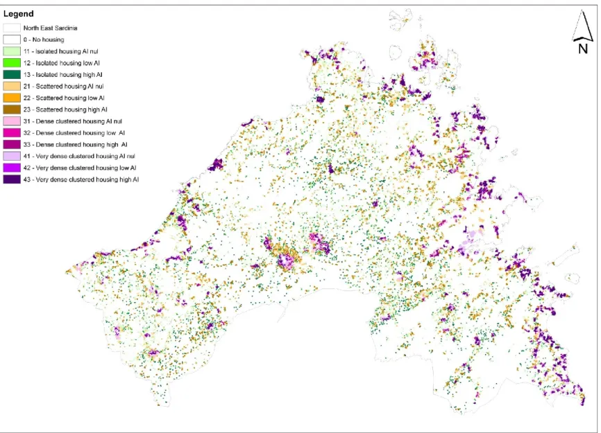
The scientific community has been optimizing the theoretical definitions and the operational mapping methods for about ten years through many different contextual applications. Having been considered in, implemented for and unceasingly improved upon mainly in European environments, the tool is particularly suitable and useful for European urban patterns and for classifying Rural Urban Interfaces. As already pointed out earlier, RUI and WUI are being used as synonyms in the literature but the first definition (RUI) refers to houses or settlements that can be immersed in many kinds of matrices, from agricultural to partially vegetated or to forested, while WUI explicitly refers to the direct contact of urbanized areas with wildland forested areas. The methodologies, developed in Europe, reflect the environmental condition in which they have been provided, but nevertheless, they are useful (and used) to classify the intermix areas that exist all over the world: Asia, north Africa, south Africa, Australia, Tasmania, north, central and south America. For the typical Euro-Mediterranean habitat across Sardinia, the tool seems to be particularly valid and apt and hence was chosen to map Sardinian RUIs.
The three methodologies implemented in RUImap® tool, were conceived with different theoretical paradigms which use different points of view and aim to model the phenomenon with different main purposes. Nowadays, in the latest version, the richness of approaches is still evident and the dissimilar theoretical lines result in maps that can differ very much in classifying and describing the same areas. The maps obtained using each of them are complementary and far from representing contradictory results, offer the possibility to a more cogent description and of a deeper knowledge of the RUI phenomenon in the territory.
Each methodology include in RUI (or exclude from it) different zones and defines a set of theoretical RUI typologies (we will call them RUI Types). “RUI types” are abstract model classes that are created according to different theoretical paradigm and that are used to classify all possible real RUI configurations. Usually there is no one-to-one correspondence between categories of different methodologies, and no way to convert one classification into another.
The three methodologies that the tool makes available permit mapping RUI at different scales: we can create maps with the Global Scale mapping methodology that works on regional-national-continental scales or with two Local Scale mapping methodologies that work at local-communal-county-provincial scales.
Study areas
The administration of Sardinia Island (Italy), provides many certified GIS strata within its official Sardegna Geoportale section. At the internet URL address
http://www.sardegnageoportale.it/index.php?xsl=1594&s=40&v=9&c=8753&n=10 (last access 11/24th/2013) ortho-photo and many certified data layers in vector and raster formats are freely available; in particular:
- All human construction on the territory (buildings, structures, streets, industrial sites, dams, railways, etc.);
- Vegetation map, Land Use map and Land Cover map; - Digital Terrain Elevation Models (1-5 m resolution); - Burned areas (obtained with certified GPS surveys);
- Satellite images with resolution ranging from 1m to 5-10m, which are very useful for photo-interpretation.
The “Corpo Forestale e di Vigilanza Ambientale”, the Sardinian Forest Service, kindly provided its certified database of ignition points that have been GPS recorded since 2004 and manually recorded, directly on Italian Military Maps (I.G.M. - 1:25000), until 2003 with a precision of 30-50 m.
Because of the high number of fires and the large burned areas as well as for the availability of accurate data, Sardinia has been chosen as study area to carry out the present work.
Sardinia, the second largest Island in Mediterranean Basin after Sicily, is a fire prone area which suffers a lot of wildfire damage since it experiences, almost every year, the highest number of fires and the largest burned areas among all Italian regions.
It is located in the occidental part of the Basin, between Spain and Italy and its surface area is 24,083.62 km2.
The average elevation is 338 m a.s.l., with approximately 38% of the surface at less than 200 m a.s.l., 50% of surface between 200 and 700 m a.s.l. and just 12% of the territory above 700 m a.s.l. Although the highest Sardinian mountains do not reach the elevation of 2000 m (Gennargentu 1,834 m a.s.l.), it can be considered a hilly-mountainous island because only about the 20% of the surface is flat while more commonly the landscape is rugged.
The climate is typically Mediterranean and has mainly two seasons, a cool and wet winter and a warm and dry summer with relatively short transition periods.
All over the island climate is mild, but especially near the coast related to the moderating action of the sea. Due to its particular placement, the island is exposed to the NW currents (Atlantic flux) as well as to the Saharan influence arriving from Northern Africa. During summer a particular synoptic configuration can generate extreme heat waves.
Moreover, during summer, the day/night breezes are constantly blowing and, during the hottest hours of the day especially close to the coastline, these local winds can also become high winds. Summers are usually long, dry, windy and warm. Each year an average of 600 mm of precipitation falls in Sardinia but, excepting the mountains, May-September rain accumulation are usually very low (<100 mm) and sometimes almost null.
The meteo-climatic station, located in Valliciola in the northern part of the island, at 1040 m a.s.l., is a Sardinian meteorological station that usually records values of annual precipitation among the highest amounts for the isle (with a mean of 1343 mm). It also registers one of the shortest dry