DISI ‐ Via Sommarive 14 ‐ 38123 Povo ‐ Trento (Italy)
http://www.disi.unitn.it
EXTENDING A GEO-CATALOGUE
WITH MATCHING CAPABILITIES
Feroz Farazi, Vincenzo Maltese, Biswanath
Dutta and Alexander Ivanyukovich
May 2011
Technical Report # DISI-11-464
Also: At the IJCAI Workshop on Discovering Meaning
On the Go in Large Heterogeneous Data (LHD 2011).
Abstract
To achieve semantic interoperability, geo-spatial applications need to be equipped with tools able to understand user terminology that is typically dif-ferent from the one enforced by standards. In this paper we summarize our experience in providing a semantic extension to the geo-catalogue of the Au-tonomous Province of Trento (PAT) in Italy. The semantic extension is based on the adoption of the S-Match semantic matching tool and on the use of a specifically designed faceted ontology codifying domain specific knowledge. We also briefly report our experience in the integration of the ontology with the geo-spatial ontology GeoWordNet.
1 Introduction
To be effective, geo-spatial applications need to provide powerful search capabilities to their users. On this respect, the INSPIRE1 directive and regulations [EU Parliament,
2009; EU Commission, 2009] establish minimum criteria for the discovery services to support search within INSPIRE metadata elements. However, such services are often limited to only syntactically matching user queries to metadata de-scribing geographical resources [Shvaiko et al., 2010]. In fact, current geographical standards tend to establish a fixed terminology to be used uniformly across applications thus failing in achieving semantic interoperability. For example, if it is decided that the standard term to denote a harbour (defined in WordNet as “a sheltered port where ships can
take on or discharge cargo”) is harbour, they will fail in
applications where the same concept is denoted as seaport. As part of the solution, domain specific geo-spatial ontol-ogies need to be adopted. Unfortunately, existing geo-spatial ontologies are limited in coverage and quality [Giunchiglia
et al., 2010b]. This motivated the creation of GeoWordNet2
- a multi-lingual geo-spatial ontology providing knowledge about geographic classes, geo-spatial entities (locations), entities’ metadata and part-of relations between them. It
1
http://inspire.jrc.ec.europa.eu/
2
A significant part of GeoWordNet is in RDF and freely available at http://geowordnet.semanticmatching.org/
represents a significant improvement w.r.t. the state of the art, both in terms of quantity and quality of the knowledge provided. As such, it currently constitutes the best candidate to provide semantic support to geo-spatial applications.
One of the purposes of the Semantic Geo-Catalogue (SGC) project [Ivanyukovich et al., 2009] - promoted by the PAT - was to extend the geographical catalogue of the PAT with semantic search capabilities. The main requirement was to allow users to submit queries such as Bodies of water
in Trento, run them on top of the available geographical
resources metadata and get results also for more specific features such as rivers and lakes. This is clearly not possible without semantic support.
In this paper we report our work in providing full support for semantic search to the geo-catalogue of the PAT. This was mainly achieved by integrating in the platform the S-Match3 semantic matching tool [Giunchiglia et al., 2010a] and by adopting a specifically designed faceted ontology [Giunchiglia et al., 2009] codifying the necessary domain knowledge about geography and including inter-alia the administrative divisions (e.g., municipalities, villages), the bodies of water (e.g., lakes, rivers) and the land formations (e.g., mountains, hills) of the PAT. Before querying the geo-resources, user queries are expanded by S-Match with do-main specific terms taken from the faceted ontology. To increase the domain coverage of both resources, we inte-grated the faceted ontology with GeoWordNet. We con-ducted an evaluation of the proposed approach to show how simple queries can be semantically expanded using the tool.
The rest of this paper is organized as follows. Section 2 describes the overall system architecture by focusing on the semantic extension. Section 3 describes the dataset contain-ing the locations within the PAT and how we cleaned it. Sections 4, 5 and 6 provide details about the construction of the faceted ontology, its population and integration with GeoWordNet, respectively. The latter step allows support-ing multiple languages, enlargsupport-ing the background ontology and increasing the coverage of locations and corresponding metadata such as latitude and longitude coordinates. Section 7 provides an evaluation showing the effectiveness of the proposed approach. Section 8 provides a generalization of
3
Freely available at http://sourceforge.net/projects/s-match/
Extending a geo-catalogue with matching capabilities
Feroz Farazi
DISI
University of Trento
[email protected]
Vincenzo Maltese
DISI
University of Trento
[email protected]
Biswanath Dutta
DISI
University of Trento
[email protected]
Alexander Ivanyukovich
Trient Consulting Group S.r.l.
Trento, Italy
the work done for the design of the faceted ontology of the PAT in the direction of a faceted ontology for the whole world. Section 9 concludes the paper.
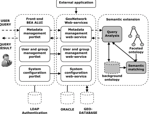
2 The architecture of the geo-catalogue
The overall architecture is constituted by the front-end, business logic and back-end layers as from the standard three-tier paradigm [Shvaiko et al., 2010]. The catalogue is one of the services of the existing geo-cartographic portal4 of the PAT. It has been implemented by
adapting available open-source tool5 conforming to the
IN-SPIRE directive and taking into account the rules enforced at the national level. Following the best practices for the integration of the third-party software into the BEA ALUI framework6 (the current engine of the geo-portal), external
services are brought together using a portlet7-based scheme,
where GeoNetwork is used as a back-end. Fig.1 provides an integrated view of the system architecture. At the front-end, the functionalities are realized as three portlets for:
metadata management, including harvesting, search and catalogue navigation functionalities;
user/group management, to administer access control on the geo-portal;
system configuration, which corresponds to the func-tionalities of the GAST (GeoNetwork's Administrator Survival Tool) tool of GeoNetwork.
4
http://www.territorio.provincia.tn.it/
5
GeoNetwork Open Source, http://geonetwork-opensource.org
6
http://download.oracle.com/docs/cd/E13174_01/alui/
7
http://jcp.org/en/jsr/detail?id=168
These functionalities are mapped 1-to-1 to the back-end services of GeoNetwork. Notice that external applications, can also access the back-end services of GeoNetwork.
The GeoNetwork catalogue search function was extended by providing semantic query processing support. To pro-vide this support we used the S-Match open source semantic
matching operator. Given two graph-like structures
seman-tic matching operators identify the pairs of nodes in the two structures that are semantically similar (equivalent, less or more specific), where the notion of semantic similarity is both at the node level and at the structure level [Giunchiglia
et al., 2008]. For instance, it can identify that two nodes
labeled stream and watercourse are semantically equivalent because the two terms are synonyms in English. This allows similar information to be identified that would be more dif-ficult to find using traditional information retrieval ap-proaches.
Initially designed as a standalone application, S-Match was integrated with GeoNetwork. As explained in [Shvaiko
et al., 2010], this was done through a wrapper that provides
web services to be invoked by GeoNetwork. This approach mitigates risks of failure in experimental code while still following strict uptime requirements of the production sys-tem. Another advantage of this approach is the possibility to reuse this service in other applications with similar needs.
In order to work properly, S-Match needs domain specific knowledge. Knowledge about the geographical domain is codified into a faceted ontology. A faceted ontology is an ontology composed of several sub-trees, each codifying a different aspect of the given domain. In our case, it includes (among others) the administrative divisions (e.g., municipal-ities, villages), the bodies of water (e.g., lakes, rivers) and the land formations (e.g., mountains, hills) of the PAT.
GeoNetwork Web-services Front-end BEA ALUI Metadata management portlet User and group
management portlet System configuration portlet Metadata management web-service User and group
management web-service System configuration web-service Query Analysis Semantic matching Faceted ontology background ontology LDAP
Authentication ORACLE DATABASEGEO-
USER QUERY QUERY RESULT External application Semantic extension
The flow of information, starting from the user query to the query result, is represented with arrows in Fig.1. Once the user enters a natural language query (which can be seen as a classification with a single node), the query analysis component translates it into a formal language according to the knowledge in the background ontology8. The formal representation of the query is then given as input to the se-mantic matching component that matches it against the fac-eted ontology, thus expanding the query with domain spe-cific terms. The expanded query is then used by the metada-ta management web-service component to query GeoNet-work and finally access the maps in the database.
3 Data extraction and filtering
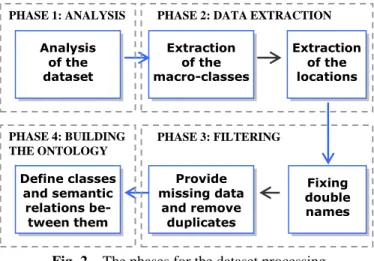
The first step towards the construction (Section 4) and popu-lation (Section 5) of the faceted ontology was to analyze the data provided by the PAT, extract the main geographical classes and corresponding locations and filter out noisy data. The picture below summarizes the main phases.
Fig. 2 – The phases for the dataset processing The dataset of the PAT
The data are available in four files and are gathered from the PAT administration. The features file contains the main 45 geographical classes; the ammcom file contains 256 munici-palities; the localita file contains 1,507 wards and ward parts, that we generically call populated places; the toponimi file contains 18480 generic locations (including inter-alia villages, mountains, lakes, and rivers). Comune, frazione and località popolata are the Italian class names for munici-pality, ward and populated place respectively.
Data extraction
We retrieved the PAT classes, that we call macro-classes, from the features file. Each class is associated an id (e.g., P110) and an Italian name (e.g., Monti principali). Names of the macro-classes need to be refined as they are too generic and represent many kinds of locations grouped together. As
8
S-Match uses WordNet by default but it is configurable
this file lacks classes for the provinces, municipalities, wards and populated places, we manually created them.
We imported all the locations into a temporary database by organizing them into the part-of hierarchy province >
municipality > ward > populated place (and other location
kinds). The entity representing the Province of Trento is not explicitly defined in the dataset but it is clearly the root of the hierarchy, so we manually created it. A few locations from the files are not connected to any place and therefore we directly connected them to the province. Each location was temporary assigned to the corresponding macro-class.
Locations are provided with latitude and longitude coor-dinates in Cartesian WGS84 (World Geodetic System 1984) format, a standard coordinate reference system mainly used in cartography, geodesy and navigation to represent geo-graphical coordinates on the Earth9. Since in GeoWordNet we store coordinates in WGS84 decimal format, for compat-ibility we converted them accordingly.
Filtering
A few location names are double names, e.g., Cresta di
Si-usi Cresta de Sousc. The first (Cresta di SiSi-usi) is in Italian
and the second (Cresta de Sousc) is in Ladin. Ladin is a language spoken in a small part of Trentino and other Al-pine regions. The combination of the two is the official name of the location in the PAT. In the temporary database, we put the Italian and Ladin names as alternative names.
While importing the entities in the temporary database, we found that 8 municipalities and 39 wards were missing in the ammcom and localita files respectively, and 35 mu-nicipalities were duplicated in the ammcom file. We created the missing locations and eliminated the duplicates. At the end of the importing we identified the objects reported in Table 1.
KIND OF OBJECT OBJECTS IMPORTED
macro-classes 44
locations 20,162
part-of relations 20,161 alternative names 7,929
Table 1. Objects imported in the temporary database
4 Building the faceted ontology
As mentioned above, the macro-classes provided by the PAT are very generic. This is mainly due to the criteria used by PAT during categorization that were based not only on type but also on importance and population criteria. With the two-fold goal of refining them and determining the miss-ing semantic relations between them, we analyzed the class names and created a multi-lingual faceted ontology.
Our final goal was to create an ontology that both reflects the specificity of the PAT and respects the canons of the analytico-synthetic approach [Ranganathan, 1967] for the
9 https://www1.nga.mil/ProductsServices/GeodesyGeophysics/ WorldGeodeticSystem/ PHASE 3: FILTERING Analysis of the dataset Extraction of the macro-classes
PHASE 2: DATA EXTRACTION Extraction of the locations PHASE 1: ANALYSIS Fixing double names Provide missing data and remove duplicates Define classes and semantic relations be-tween them PHASE 4: BUILDING THE ONTOLOGY
generation of a faceted ontology. A faceted (lightweight) ontology [Giunchiglia et al., 2009] is an ontology divided into sub-trees, called facets, each encoding a different di-mension or aspect of the domain knowledge. As a result, it can be seen as a collection of lightweight ontologies [Giunchiglia and Zaihrayeu, 2009].
From macro-classes to atomic concepts
We started from the 45 macro-classes, which are not ac-companied by any description. Therefore, by analysing the locations contained in the macro-classes, each class was manually disambiguated and refined (split, merged or re-named) and as a result new classes had to be created. This was done through a statistical analysis. Given a macro-class, corresponding locations were searched in GeoWordNet. We looked at all the locations in the part-of hierarchy rooted in the Province of Trento having same name and collected their classes. Only a little portion of the locations were found, but they were used to understand the classes corre-sponding to each macro-class. The identified classes were manually refined. Some of them required a deeper analysis.
At the end of the process we generated 39 refined classes, including the class province, municipality, ward and
popu-lated place previously created. Each of these classes is what
we call an atomic concept.
Arrange atomic concepts into hierarchies
By identifying semantic relations between atomic concepts and following the analytico-synthetic approach we finally created the faceted ontology of the PAT with five distinct facets: antiquity, geological formation (further divided into
natural elevation and natural depression), body of water, facility and administrative division. As an example, below
we provide the body of water facet (in English and Italian).
Body of water (Idrografia)
Lake (Lago)
Group of lakes (Gruppo di laghi) Stream (Corso d’acqua)
River (Fiume) Rivulet (Torrente) Spring (Sorgente) Waterfall (Cascata) Cascade (Cascatina) Canal (Canale)
5 Populating the faceted ontology
Each location in the temporary database was associated a macro-class. The faceted ontology was instead built using the atomic concepts generated from their refinements. In order to populate the faceted ontology, we assigned each location in the temporary database to the corresponding atomic concept by applying some heuristics based on the entity names. As first step, each macro-class was associated to a facet. Macro-classes associated to the same facet consti-tute what we call a block of classes. For instance, the
macro-classes from P110 to P142 (11 macro-classes) correspond to the
natural elevation block, including inter-alia mountains,
peaks, passes and glaciers. Facet specific heuristics were applied to each block.
For instance, entities with name starting with Monte were considered as instances of the class montagna in Italian (mountain in English), while entities with name starting with Passo were mapped to the class passo in Italian (pass in English). The general criterion we used is that if we can successfully apply a heuristic then we classify the entity in the corresponding (more specific) class otherwise we select a more generic class, that is the root of a facet (same as the block name) in the worst case. For some macro-classes we reached a success rate of 98%. On average, nearly 50% of the locations were put in a leaf class thanks to the heuristics. Finally, we applied the heuristics beyond the boundary of the blocks for further refinement of the instantiation of the entities. The idea was to understand whether, by mistake, entities were classified in the wrong macro-class. For in-stance, in the natural depression block (the 5 macro-classes from P320 to P350), 6 entities have name starting with
Monte and therefore they are supposed to be mountains
in-stead. The right place for them is therefore the natural
ele-vation facet. In total we found 48 potentially bad placed
entities, which were checked manually. In 41.67% of the cases it revealed that the heuristics were valid, in only 8.33% of the cases the heuristics were invalid and the rest were unknown because of the lack of information available on the web about the entities. We moved those considered valid in the right classes.
6 Integration with GeoWordNet
With the previous step the locations in the temporary data-base were associated to an atomic concept in the faceted ontology. The next step consisted in integrating the faceted ontology and corresponding locations with GeoWordNet.
Concept integration
This step consisted in mapping atomic concepts from the faceted ontology to GeoWordNet concepts. We automated the disambiguation process with a little amount of manual intervention. Basically, we first manually identified the con-cept corresponding to the root of each facet - that we call the
facet concept - and then we restricted the matching of the
atomic concepts in the facet to the sub-tree rooted in the facet concept in GeoWordNet. For instance, we restricted the matching of mountain to only those concepts more spe-cific than natural elevation. If a candidate was found the corresponding concept was selected, otherwise a more gen-eral concept, i.e. a suitable parent, was searched. If neither the concept nor the parent was identified, we went for man-ual intervention.
Entity matching and integration
Two partially overlapped entity repositories, the temporary database built from the PAT dataset (i.e. the populated
fac-eted ontology) and GeoWordNet, were integrated. The PAT dataset overall contains 20,162 locations. GeoWordNet con-tains nearly 7 million locations from all over the world, in-cluding some locations of the PAT. We imported all but the overlapping entities from the temporary database to Ge-oWordNet. We also automatically generated an Italian and English gloss for each entity. We used several rules, accord-ing to the language. In order to detect the duplicates we ex-perimented different approaches. We found that in order to maximize accuracy two entities must match only if they have same name, coordinates, class, parent entities, children entities and alternative names. We allowed a tolerance in matching the coordinates of +/- 0.05, corresponding to +/- 5.5 Km. Note that while matching classes, we took into ac-count the subsumption hierarchy of their concepts. For in-stance, Trento as municipality in the PAT dataset is matched with Trento as administrative division in GeoWordNet be-cause the former is more specific than the latter.
7 Evaluation
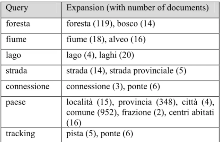
In order to improve the results associated to a user query, S-Match is used to match terms in the query with the faceted ontology. The background knowledge used for the matching is WordNet, but the tool is developed in such a way to allow substituting it with any other ontology. The matching terms are used to enrich those in the query thus obtaining a seman-tic query expansion. It is expected that such richer queries, given in input to GeoNetwork, would return a higher num-ber of results. To prove the effectiveness of the approach followed, in Table 2 we provide some examples of queries and the terms in their extension.
Query Terms identified by S-Match Watercourse Rivulet, Stream, River Falls Cascade, Waterfall
Elevation Natural elevation, Mountain, Highland, Glacier, Mountain range, Peak, Hill Mount Mountain pass, Mountain, Mountain
range
Installation Milestone, Hut, Farm, Highway, Rail-way, Road, Street, Transportation sys-tem, Provincial Road, Facility, Shelter Water Rivulet, Waterfall, Cascade, River,
Body of water, Stream, Spring, Canal, Group of lakes, Lake
Transportation
facility Transportation system, Road, Street, Provincial Road, Milestone, Railway, Highway
Reef
Table 2. Some query expansion results
The last example shows how typing the query reef would not produce any result. This depends on the fact that the
faceted ontology strictly codifies the local specificities of the Province of Trento that does not present any marine en-vironment (it is a mountain region far from the sea). In all the other cases it is evident how S-Match identifies semanti-cally related terms (synonyms, less or more specific terms).
Table 3 shows real results in terms of documents found. The portal actually interacts with the users in Italian. The Italian query is translated in English, matched with the fac-eted ontology and, once processed, results are given back in Italian. Only terms matching with at least one document are returned. For instance, the query for tracking returns only
pista (track) and ponte (bridge), since no documents are
available in the repository for the term tracking.
Query Expansion (with number of documents) foresta foresta (119), bosco (14)
fiume fiume (18), alveo (16) lago lago (4), laghi (20)
strada strada (14), strada provinciale (5) connessione connessione (3), ponte (6)
paese località (15), provincia (348), città (4), comune (952), frazione (2), centri abitati (16)
tracking pista (5), ponte (6)
Table 3. Some query expansion results
Note that by populating the ontology with locations and taking into account the part-of relations between them, also location names can be expanded. For instance, by providing the information that Povo is an administrative division in
Trento it is possible to expand the term Trento with Povo.
However, providing this support was out of the scope of the SGC project.
8 Extending the faceted ontology
The work done with the PAT for the construction of the faceted ontology can be generalized to cover the whole world. We recently worked on a methodology - mainly in-spired by the faceted approach - and a minimal set of guid-ing principles aimed at modelguid-ing the spatial domain (and in general any domain) and at building the corresponding background knowledge taking into account the classes, the
entities, their attributes and relations [Dutta et al., 2011].
We consider classes, relations, and attributes as the three fundamental components, or categories, of any domain. In this approach, the analysis of the domain allows the identifi-cation of the basic classes of real world objects. They are arranged, per genus et differentia (i.e. by looking at their commonalities and their differences), to construct the facets, each of them codifying a different aspect of the domain at hand. This allows being much more rigorous in the defini-tion of the domain and its parts, in its maintenance and use [Giunchiglia et al., 2009].
We selected the classes from GeoWordNet and arranged them into 8 facets, each of them further divided into sub-facets: region, administrative division, populated place, fa-cility, abandoned fafa-cility, land, landform and body of water. The spatial relations we propose extend those in [Pullar and Egenhofer, 1988]. In addition to the standard direction, topological, ordinal, distance and fuzzy relations, we extend them by including relative level (e.g. above, below), longi-tudinal (e.g. in front, behind), side-wise (e.g. right, left), position in relation to border or frontier (e.g. adjacent, over-lap) and other similar relations. We also consider functional relations. For example, in the context of lakes, primary in-flow and primary outin-flow are two important relations.
An attribute is an abstraction belonging to or a character-istic of an object. This is a construct through which objects or individuals can be distinguished. Attributes are primarily
qualitative and quantitative in nature. For example, we may
mention depth (of a river), surface area (of a lake), length (of a highway) and altitude (of a hill). For each of these at-tributes, we may have both qualitative and quantitative val-ues. We store the possible qualitative values in the back-ground knowledge. This provides a controlled vocabulary for them. They are mostly adjectives. For example, for depth (of a river) the possible values are {wide, narrow}. Similarly, for altitude (of a hill) the possible values are {high, low}. We also make use of descriptive attributes. They are used to describe, usually with a short natural lan-guage sentence, a specific aspect of an entity. Typical ex-amples are the history (of a monument) or the architectural style (of a building) or any user defined tag.
Our space domain overall includes 845 classes, 70 rela-tions and 35 attributes. In comparing it with existing geo-spatial ontologies, like GeoNames and TGN, our space do-main is much richer in all its aspects. Further details can be found in [Dutta et al., 2011].
9 Conclusions
We briefly reported our experience in providing a semantic extension to the geo-catalogue of the PAT. S-Match, once integrated with GeoNetwork, performs a semantic expan-sion of the query using a faceted ontology codifying the domain knowledge about geography of the PAT. This al-lows identifying information that would be more difficult to find using traditional information retrieval approaches.
To mutually increase their coverage, we have also inte-grated the faceted ontology with GeoWordNet. At this pur-pose we had to match their concepts and entities. The matching of the concepts was done by focusing on one facet at a time. The entity matching criteria needed to be tuned to maximize accuracy. We also briefly reported the methodol-ogy that we use to build domains and how we applied it to the space domain on top of GeoWordNet.
Acknowledgments
This work has been supported by the TasLab network pro-ject funded by the European Social Fund under the act n° 1637 (30.06.2008) of the PAT, by the European
Communi-ty's Seventh Framework Programme (FP7/2007-2013) under grant agreement n° 231126 LivingKnowledge: Living-Knowledge - Facts, Opinions and Bias in Time and by “Live Memories - Active Digital Memories of Collective Life” funded by the PAT. We are thankful to Pavel Shvaiko, Aliaksandr Autayeu, Veronica Rizzi, Daniela Ferrari, Giuli-ana Ucelli, Monica Laudadio, Lydia Foess and Lorenzo Vaccari for their kind support.
References
[Dutta et al., 2011] B. Dutta, F. Giunchiglia, V. Maltese. A facet-based methodology for geo-spatial modelling. In
Proceedings of the GEOS, Vol. 6631, 2011.
[EU Commission, 2009] European Commission. COM-MISSION REGULATION (EC) No 976/2009 imple-menting Directive 2007/2/EC as regards the Network Services, 2009.
[EU Parliament, 2009] European Parliament. Directive 2007/2/EC establishing an Infrastructure for Spatial In-formation in the European Community (INSPIRE), 2009.
[Giunchiglia et al., 2008] F. Giunchiglia, F. McNeill, M. Yatskevich, J. Pane, P. Besana, and P. Shvaiko. Approximate structure-preserving semantic matching. In
Proceedings of ODBASE, 2008.
[Giunchiglia and Zaihrayeu, 2009] F. Giunchiglia, I. Zaihrayeu. Lightweight Ontologies. The Encyclopedia of
Database Systems, 2007
[Giunchiglia et al., 2009] F. Giunchiglia, B. Dutta, V. Maltese. Faceted Lightweight Ontologies. In “Conceptu-al Modeling: Foundations and Applications”, A. Bor-gida, V. Chaudhri, P. Giorgini, Eric Yu (Eds.) LNCS 5600 Springer, 2009.
[Giunchiglia et al., 2010a] F. Giunchiglia, A. Autayeu, J. Pane. S-Match: an open source framework for matching lightweight ontologies. The Semantic Web journal, 2010. [Giunchiglia et al., 2010b] F. Giunchiglia, V. Maltese, F. Farazi, B. Dutta. GeoWordNet: a resource for geo-spatial applications. In Proceedings of ESWC, 2010. [Ivanyukovich et al., 2009] A. Ivanyukovich, F.
Giunchiglia, V. Rizzi, V. Maltese. SGC: Architettura del sistema. TCG/INFOTN/2009/3/D0002R5 report, 2009. [Pullar and Egenhofer, 1988] D. Pullar, M. J. Egenhofer.
Toward formal definitions of topological relations among spatial objects. In Proceedings of the 3rd
Interna-tional Symposium on Spatial Data Handling, Sydney, Australia, pp. 165–176, 1988.
[Ranganathan, 1967] S. R. Ranganathan. Prolegomena to library classification. Asia Publishing House, 1967. [Shvaiko et al., 2010] P. Shvaiko, A. Ivanyukovich, L.
Vaccari, V. Maltese, F. Farazi. A semantic geo-catalogue implementation for a regional SDI. In