TABLE OF CONTENTS
ACKNOWLEDGMENTS... 3
DESCRIPTION OF FRANCESCA PRIMATIVO’S MAIN RESEARCH
ACTIVITIES 2006-2009 ... 4
SOMMARIO ... 7
ABSTRACT ... 9
1
INTRODUCTION ... 11
1.1
GENERAL INTRODUCTION ... 11
1.2
INTRODUCTION OF THE PROBLEM ... 14
1.3
HOW TO CONTEND WITH PROBLEM OF PLANNING ... 18
1.4
TARGETS ... 21
1.5
LAYOUT ... 22
2
LITERATURE REVIEW... 23
2.1
INTEGRATION OF COMPLEX PROBLEM ... 23
2.2
LEGAL BACKGROUND ... 28
3
DESCRIPTION OF THE MODEL ... 33
3.1
INTRODUCTION ... 33
3.2
LAND USE CHANGE MODEL ... 34
3.2.1 BACKGROUND: URBAN GROWTH PATTERN AND CELLULAR AUTOMATON ... 35
3.2.2 MODEL DESCRIPTION ... 38
3.3
URBAN DRAINAGE SYSTEM MODEL ... 39
3.3.1 BACKGROUND ... 42
3.3.2 MODEL DESCRIPTION ... 43
3.4
WASTEWATER TREATMENT PLANT ... 47
3.4.1 BACKGROUND ... 49
3.4.2 MODEL DESCRIPTION ... 49
4.1
ASSUMPTION ... 51
4.2
HOW TO DEAL WITH SINGLE INPUT-OUTPUT ... 54
4.2.1 LAND USE CHANGE MODEL ... 54
4.2.1.1 I/O Table ... 57
4.2.2 URBAN DRAINAGE MODEL... 58
4.2.2.1 I/O Table ... 59
4.2.3 WASTEWATER TREATMENT PLANT MODEL ... 61
4.2.3.1 I/O Table ... 61
4.3
INTEGRATION AMONG THE COMPONENT ... 63
5
CASE STUDY ... 67
5.1
INTRODUCTION ... 67
5.2
DEVELOPMENT OF URBAN PLANNING SCENARIOS ... 71
5.3
DESCRIPTION OF THE CASE STUDY ... 75
6
APPLICATION TO THE CASE STUDY ... 78
7
CONCLUSIONS ... 127
7.1
A SHORT SUMMARY ... 127
7.2
CONTRIBUTIONS OF THE PRESENT WORK ... 128
7.3
WORK CONCLUSIONS ... 128
7.4
FUTURE WORK RECOMMENDATIONS ... 130
8
REFERENCES ... 131
ACKNOWLEDGMENTS
This Thesis is part of the Integrative Systems and the Boundary Problem (ISBP) project (www.tigress.ac/isbp), supported by the European Union’s Framework 6 Programme New and Emerging Science and Technology Pathfinder initiative.
I wish to specially thank the partner of the research project, which allowed the development of this Thesis, and in particular, Dr. Angelo Doglioni, my great friend and colleague.
I wish to express my gratitude and thanks to:
• Prof. Orazio Giustolisi, my supervisor, for his encouragements and his strength in supporting me during my research activities.
• Prof. Patrizia Piro, my co-supervisor, for her support during my doctoral activities. • All the people of my research group in Taranto.
• All the people of the Centre for Water Systems in Exeter for their support and friendship. I wish to specially thank my parents, my sister and my niece, for their endless support and love. Finally, thanks to Morgan and my grandparents, because they are always with me.
DESCRIPTION OF FRANCESCA PRIMATIVO’S MAIN
RESEARCH ACTIVITIES 2006-2009
The PhD research activities were mainly carried on at the Faculty of Engineering in Taranto of the Technical University of Bari (Politecnico di Bari) and at the Centre for Water Systems in the School of Engineering, Computing and Mathematics of the University of Exeter. In particular, Miss Primativo was appointed as Research Assistant (Honorary) at the University of Exeter.
Miss Primativo co-authored the following paper, published in an international scientific journal ISI:
1. Doglioni A., Primativo F., Laucelli D., Monno V., Giustolisi O. and Khu, S.T., (2009): “An integrated modelling approach for the assessment of land use change effects on wastewater infrastructures”, Environmental Modelling and Software, Elsevier, the Netherlands, Vol. 24, n.12, pp. 1522-1528, doi:10.1016/j.envsoft.2009.06.006. ISSN 1364-8152. Impact Factor
2.659 (2008).
Miss Primativo co-authored the following papers presented at international/national conferences: 1. Doglioni A., Primativo F., Savic D. and Giustolisi O., (2007): “Possible scenarios of
contaminant diffusion in water distribution systems: which is the best moment to place a strike?”, in proceedings of Computer and Control in Water Industry (CCWI) - Water Mangement Challanges in Global Changes – Ulaniki et al. (eds), Taylor & Francis Group, London, pp. 257-263, ISBN 978-0-415-45415-5.
2. Berardi L., Giustolisi O. and Primativo F., (2007): “Exploiting multi-objective strategies for optimal rehabilitation planning”, in Proceedings of Computer and Control in Water Industry (CCWI) - Water Mangement Challanges in Global Changes – Ulaniki et al. (eds), Taylor & Francis Group, London, pp. 23-30, ISBN 978-0-415-45415-5.
3. Primativo F., Doglioni A., Laucelli D. and Giustolisi O., (2007): “La diffusione di contaminanti in rete: integrazione con un’analisi pressure-driven ed un modello di perdita”, in La ricerca delle perdite e la gestione delle reti di acquedotto, 20-21 September 2007, Morlacchi Editore, Perugia, Italy, Marzo 2008, pp. 81-94, ISBN 978-88-6074-173-8.
4. Doglioni A., Primativo F., Laucelli D., Monno V. and Giustolisi O., (2008): “An integrated modelling approach for the assessment of land use change effects on wastewater infrastructures”, in d’Antonio G., Lubello C., Proceedings of the International Symposium on Sanitary and Environmental Engineering, SIDISA 2008, 24-27 June 2008, Firenze, Italia, ISBN 978-88-903557-0-7.
5. Fu G., Khu S.-T., di Pierro F., Doglioni A. and Primativo F., (2008): “Development of an integrated framework for assessing the impact of urban planning on water quality”, in Miquel Sànchez-Marrè, Javier Béjar, Joaquim Comas, Andrea E. Rizzoli, Giorgio Guariso (Eds.), proceedings of the iEMSs Fourth Biennial Meeting: International Congress on Environmental Modelling and Software (iEMSs 2008). International Environmental Modelling and Software Society, Barcelona, Catalonia, July 2008. Vol. 1, pp. 592-597, ISBN 978-84-7653-074-0.
6. Primativo F., Doglioni A. and Giustolisi O., (2008): “Wastewater facilities and urban development: an integrated framework”, XXXI Convegno Nazionale di Idraulica e Costruzioni Idrauliche, a cura di Brunone, Ferrante e Meniconi, Perugia, 09-12 September 2008. ISBN 978-88-6074-220-9.
7. Doglioni A., Primativo F. and Giustolisi O., (2008): “Scenarios of contaminant diffusion on a medium size urban water distribution network”, Proceedings of the 10th Annual Water Distribution Systems Analysis Conference WDSA2008, Van Zyl, J.E., Ilemobade, A.A., Jacobs, H.E. (eds.), 17-20 August 2008, Kruger National Park, South Africa, pp. 951-965. ISBN 978-07-8441-0240. doi:10.1061/41024(340)84.
8. Doglioni A., Primativo F. and Giustolisi O., (2009): “A more realistic simulation of a real water distribution system based on an enhanced demand driven model”, in Boxall J. and Maksimovic C., (eds.), in proceedings of Computer and Control in Water Industry, CCWI 2009, Integrating Water Systems, pp. 195-201, 1-3rd September 2009, ISBN 13 978-0-415-54851-9.
9. Doglioni A., Primativo F. and Giustolisi O., (2009): “An integrated modelling approach for the assessment of land use change effects on wastewater infrastructures”, in A. Paoletti, G. Becciu, C. Di Mauro, R. Occhi, A. Rossi, U. Sanfilippo, Eds., Acqua e Città 2009 - 3° convegno nazionale di idraulica urbana, Milano, 6-9 October 2009. ISBN 978-88-903223-3-4.
During the PhD, Miss Primativo attended the following international events, during which she presented three works among those previously mentioned:
• Meeting of the European Project “Integrative Systems and the Boundary Problem” (ISBP), in Exeter (UK) 09-10 July 2007.
• “Water Management Challenges in Global Change” CCWI2007 and SUWM2007 Conference, in Leicester (UK) 03-05 September 2007 (oral presentation).
• “Water Distribution System Analysis” WDSA2008 Conference, to the Kruger National Park (South Africa), 17-20 August 2008 (oral presentation).
• Meeting of the European Project “Integrative Systems and the Boundary Problem” (ISBP), in Abisko (Sweden), 14-20 January 2009.
• “Computing and Control in the Water Industry Integrating Water Systems” CCWI2009 Conference, in Sheffield (UK), 01-03rd September 2009 (oral presentation).
• Research and collaboration with a group of the Centre for Water Systems in the School of Engineering Computer Science and Mathematics of the University of Exeter (UK) for a total period of seven months.
Miss Primativo was also involved in the following Research Projects:
• “Integrative Systems and the Boundary Problem – ISBP” – supported by the European Union’s Framework 6 Programme New and Emerging Science and Technology (NEST) Pathfinder initiative, NEST-2005-Path-CUL(Contract 043199).
• “Multi-objective evolutionary optimization and data-driven techniques for water system management” – Internationalization of the Italian University System: Interlink – MIUR.
SOMMARIO
L’effetto dell’espansione urbana e della modifica del territorio, costituisce una fonte di impatto sul trasporto e trattamento delle acque reflue ed è pertanto un aspetto gestionale delle infrastrutture idrauliche imprescindibile. In particolare, spesso accade che le reti di drenaggio siano ampliate, connettendo ad esempio aree di nuova edificazione, senza uno studio modellistico preventivo delle conseguenze che tali interventi recheranno sulle infrastrutture esistenti quali rete fognaria ed impianto di trattamento (Butler & Davies, 2004).
La presente Tesi di Dottorato, prendendo spunto dalle attività svolte all’interno del Progetto di Ricerca Europeo Integrative Systems and the Boundary Problem (ISBP), tratta lo sviluppo e l’analisi applicativa di modelli di integrazione di fenomenologie aventi ripercussioni dirette e/o indirette sull’inquinamento delle acque. In particolare, l’integrazione fra modelli ha lo scopo di simulare il comportamento di un bacino urbano reale al servizio del quale esiste un impianto di trattamento e smaltimento reflui.
Lo studio di tali modelli si è incentrato sull’approfondimento di metodologie riguardanti la modellazione delle relazioni intercorrenti fra sviluppo urbano e tutela dall’inquinamento delle acque. Tale modellazione si è ottenuta attraverso l’implementazione di un framework, il cui scopo riguarda:
• dinamiche di processo, quali l’utilizzo del suolo e la qualità delle acque; • il collegamento fra i processi suddetti, come l’aggregazione spaziale dei dati; • l’integrazione dei modelli nello stesso ambiente di calcolo (Simulink).
Nella fattispecie sono stati integrati un modello di cambiamento di uso del suolo atto a simulare l’espansione urbana di un’area di nuovi insediamenti, con un solutore idraulico che simula il trasporto dei reflui e dei principali inquinanti in esso contenuti e infine un modello di simulazione di un impianto di trattamento reflui. Il modello di simulazione idraulica del bacino è basato sul solutore Storm Water Management Model (SWMM) implementato dalla US Environmental Protection Agency (USEPA), mentre il modello di simulazione dell’impianto di trattamento reflui è basato sul solutore sviluppato dall’IWA Task Group on Benchmarking of Control Strategies (BCS), in particolare sul modello BSM1.
Sulla base della simulazione di potenziali scenari di sviluppo si opererà una valutazione preventiva degli impatti delle espansioni urbane sulle reti di drenaggio e sugli impianti di trattamento e smaltimento reflui conseguenti allo sviluppo di nuove aree urbane secondo un approccio maggiormente sostenibile rispetto a tali infrastrutture, minimizzando il rischio di sversamenti diretti ed incontrollati di reflui nell’ambiente.
Il framework sviluppato consentirà di valutare e pianificare lo sviluppo urbano secondo un approccio innovativo che tenga conto dell’integrazione delle nuove opere con quelle già esistenti ed in uno scenario di eco-sostenibilità. Inoltre, il framework sviluppato potrà anche essere la base per possibili ulteriori integrazioni con altri strumenti di analisi ambientale e del territorio, dando l’opportunità ai pianificatori di decidere secondo un approccio che tenga in considerazione aspetti normalmente affrontati dopo che le politiche di sviluppo sono già decise. Ciò consente anche di produrre delle linee guida nuove nell’ambito della pianificazione territoriale.
L’obiettivo primario di questa Tesi è la descrizione ed il test del framework integrato costituito, come precedentemente accennato, da un modello di uso del suolo, un modello di drenaggio urbano ed un modello di un impianto di trattamento e smaltimento reflui urbani. Fra gli obiettivi da conseguire attraverso l’uso del predetto framework vi è lo studio di come la conoscenza empirica può essere utilizzata in modelli numerici o tecniche computazionali per lo sviluppo di una procedura di parametrizzazione automatica.
La prima parte della Tesi si articola sulla descrizione dei problemi di pianificazione rispetto ai potenziali impatti sulle infrastrutture idriche attraverso anche la rassegna della principale letteratura scientifica in merito ai problemi cosiddetti a dinamica complessa e gli aspetti legislativi concernenti il problema della tutela delle acque dall’inquinamento.
Nella seconda parte della Tesi è proposta una descrizione approfondita dei modelli utilizzati e di come essi siano stati integrati.
Ed infine, l’ultima parte della Tesi, presenta l’applicazione del framework sviluppato ad un caso studio e la descrizione dei risultati ottenuti da tale applicazione, ipotizzando alcuni potenziali scenari di sviluppo urbano.
ABSTRACT
The simulation of sewage systems and wastewater treatment plants is a strategic aspect for assessing the effect of new dwellings on the existing water facilities. This constitutes a quite common problem, since usually new edification areas are planned without looking at the effect that new scenarios will cause on the existent infrastructures.
In this Thesis integration of water pollution and land use change models is presented and applied to a case study. The water pollution is meant as the complex relationship between proposed housing development and wastewater pollution incident control. The aim of these models is about the impact of new edification areas on the existent watercourse.
This Thesis introduces an integrated framework made by a land use change model, a sewage system simulator and a wastewater treatment plant simulator. This is a complex system since each element is characterized by different dynamics. The land use change model simulates the expansion of an urban area according to planners’ guidelines; the sewage system simulator investigates the response of the drainage system to the expansion as well as its flexibility. The wastewater treatment plant is simulated in order to assess the impact of the new inflowing discharges on the existing plant.
This Thesis describes the motivation, the rational and implementation details of a modeling framework namely Stochastic System Dynamics Integrative Model (SSDIM), which is an effort to bridge the gap of integrated models for decision making in urban planning. By combining automatic decision support tools with an integrated framework that brings together land use change and wastewater network infrastructure, it enables the analysis of the effect of alternative long-term urbanisation plans on the quality of the surrounding environment, measured through water indicator. The functionality of the SSDIM was demonstrated through a semi-hypothetical case study, in which three planning scenarios were evaluated for a new housing area against the quality of the wastewater drained by a sewer system and eventually treated by a wastewater treatment plant. On the one hand, the study highlighted the flexibility in representing planning scenarios and setting-up the sewer networks in the framework and demonstrated that the framework, as a conceptual and quantitative tool, can easily accommodate for the complexity involved in a real-world case study. On the other hand, the results emphasised that the framework was able to capture the evolving
impact of urban planning over a long term period, which play an important role in understanding the existing system and environmental capacities, and thus SSDIM provides a valuable decision support aid in the urban planning process.
In the first part of this Thesis, the setting and motivation for the framework proposed and an extensive review of the studies available from literature are discussed as well as the legal background related to the problem at stake
The second part of the Thesis presents the elements of the models implemented: in particular, both the conceptual representation and the implementation details are discussed in depth.
Finally in the last part of the Thesis, an application of the developed framework to a real world environmental problem and the results of the application of the framework to a case study is described. The case study represents a sewage network of a town located in south west of Scotland and its wastewater treatment plant, where some urban development scenarios are assumed.
1 INTRODUCTION
1.1 GENERAL INTRODUCTION
In the late 80's and early 90's there are major changes in the policies of urban drainage through new concepts such as:
• sustainable development;
• management of water resources with ecosystem-wide approach; • improving the knowledge base of the impacts resulting from spills; • the integrated vision of urban drainage systems.
Until now, therefore, the two main instances that we tried to solve were the public health and protection from flooding. To date, however, there are still many points to address (Chocat et al., 2001), including:
• problems related to the volume of runoff: large sealed areas causing peak flow and less infiltration, thereby increasing the erosive power of runoff, and groundwater depletion, and thus often subsidence.
• Problems related to the qualitative aspect of the outflows: the network is mixed or separate, the waters of rain wash away urban basins are recognized as a major source of pollutants to the receptors.
• Problems associated with ecology, and use of water. The urban drainage systems may alter the biodiversity of receptors, compromising the ecological integrity, and possibly even compromising usability for recreational purposes such as bathing, fishing.
• Problems associated with managing networks currently exist, particularly related to the management of treatment plants under high load, aging pipelines, climate change.
To address these new issues it is clear that we need an integrated way, able to take into account all the subsystems that interact in urban settings. Drainage network, sewage plant and receivers must be seen as part of a single system through an integrated view.
In recent years it is imposing a new approach in the management of urban drainage systems in which all components of the system are considered as mutually dependent. In a perspective of this type, the surface sources such as groundwater, the receiver, as the settlement itself, are seen as a single system and interacting. The integrated vision system involves a greater focus in the identification of intervention strategies. So far, the optimization process was carried out with the only purpose of improving the area of interest, without considering the impact on other subsystems.
A typical case is that of storm drains, built just to relieve portions of the network to carry in excess, or protect the delicate balances within the treatment plant from toxic shocks of rain water, sewers mixed. The construction practice, until a few years ago, did not take into account the self-purification capacity of the recipient, but merely laid down the criteria for sizing of the structures, regardless of the stream which would receive the flow unfilled. The integrated view also involves the evaluation of the relationship between the individual parts of the system.
The sewage system interacts with the receptor through the storm drains. To reduce the impacts are possible different intervention strategies. But it’s important to consider all possible consequences resulting from the remaining components of the system.
The simulation of sewage systems and wastewater treatment plants is a strategic aspect for assessing the effect of new dwellings on the existing water facilities. This constitutes a quite common problem, since usually new edification areas are planned without looking at the effect that new scenarios will cause on the existent infrastructures.
Land use planning is a crucial task that has large impact on our lives. It drives economic development, affects social structures, shapes the urban landscape and modifies the environment.
Although notorious, these effects are difficult to be quantified and assessed. Their impacts are not always self-explanatory, and then complex conceptual cause-effect networks must be devised in order to appreciate them.
Moreover, they typically unfold over a time-scale that prevents them from being effectively accounted for and budgeted in any today’s decision making process.
The development of a new area can dramatically affect water flow and water quality of urban water systems in several aspects (Butler and Davies, 2004). Covering the ground with paved surfaces and land use changes increase the amount and speed of surface runoff, and thus accelerate the wash-off and transport of pollutants and sediments, particularly in the first flush period.
New domestic and industrial wastewater imposes increasing pressure on existing wastewater infrastructures (drainage and treatment), increasing the risk of sewer overflows in a combined system and of limits exceeding concentrations in receiving watercourses (after treatment processes). In order to reduce these risks, and the costs of mitigation of the related impacts, planning for new development should be coordinated with the planning of provision of water infrastructures.
Moreover, this should be done taking into consideration that urban planning is usually undertaken over long term scenarios, that urbanisation evolves gradually, that engineering works are phased over time and the economical lifecycle of water infrastructures is in the order of 15-25 years.
1.2 INTRODUCTION OF THE PROBLEM
This Thesis focuses on sustainable urban planning in relation to the impact of urbanisation on urban water systems. The water pollution is meant as the complex relationship between proposed housing development and wastewater pollution incident control. The estimation of the impact of new development on existing watercourse is currently a statutory requirement in most EU countries. The EU Water Framework Directive (WFD), adopted in 2000, has set a number of deadlines to be met by Member States to reach good quantitative and qualitative status of all water bodies (CEC, 2000). There is a need to be able to model the complex interaction between infrastructure system (such as housing development and sewer networks), natural systems (such as catchment and watercourse) and social system (impact of flooding on livelihood).
The main purposes of the developed framework are:
• integration of component models via cyclic dynamic feedback relationships,
• quantifying the behaviour of different component models and sub-cyclic systems with the developed framework and
• understanding the system behaviour and its boundaries.
Thus, the system dynamics model must be capable of providing dynamic feedback relationships between:
• water pollution incidents,
• population growth and demographic change and • infrastructure provisions.
In fact, there are still gaps in understanding the interrelationship of physical and economic behaviour of the wastewater infrastructure, how to model the infrastructure and the impact of different management strategies (Wirahadikusumah et al., 2001). Even less well understood is the relationship between proposed land development and risk of water pollution events such as flooding caused by wastewater infrastructure failure.
Wastewater Infrastructure Planning and Management (WIPM) is undergoing significant rethinking: sewer performance, asset maintenance, flooding due to sewer overflow and the costs
associated with provision of acceptable wastewater infrastructure services are beginning to play an important role when proposed housing developments are being considered.
The problems associated with deterioration of wastewater infrastructure and the consequences of inadequate maintenance plan are far from obvious; the occurrences of water pollution events are normally good indicators of sewer failures but the price to pay may be too high. Hence, there is a growing advocate that WIPM should be incorporated into land use plans. There is a strong case for sewerage service providers to demonstrate that their WIPM practices can deliver robust performance that meet regulatory requirements and those investments are sustainable as well as economically, socially and environmentally justifiable.
In outline, the integration among these problems should comprise the following functional components:
• housing development and Land Use Change model (LUC), • Urban Drainage Model (UDM),
• Wastewater Treatment Plant model (WWTP).
This Thesis introduces an integrated framework, namely Stochastic System Dynamics Integrative Model (SSDIM), made by a land use change model, a sewage system simulator and a wastewater treatment plant simulator. The framework is implemented into Simulink, which allows for a system dynamics modeling of the different processes in various components and the interactions between them.
The housing development and Land Use Change Model (LUC) will allow the housing densities, types, locations etc. to be characterized and projected forward in time. It will be bounded geographically within the study area and socially via population preference of housing and affordability. It is envisaged that LUC is multi-agent based (Hercog and Fogarty, 2001).
The hydraulic simulator is based on the Storm Water Management Model developed by the US Environmental Protection Agency. The Urban Drainage Model (UDM) will allow the accounting of total water budget within the study area. It will have a hydrologic model that accounts for the amount of inflow and discharge, links to LUC and WWTP to account for runoff within the system. It will provide the main driver for any occurrence of sewer flooding.
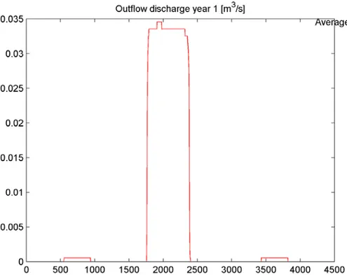
The wastewater treatment plant model is based on the model developed by the IWA Task Group on Benchmarking of Control Strategies, in particular the BSM1 model. The Wastewater Treatment Plant model (WWTP) will be used to model the flow hydraulics and system performance in terms of dry weather flows, wet weather flows and sedimentation. A major operational concern for urban drainage systems is their performance under wet weather flows and especially the onset of hydraulic incapacity in system and any resultant flooding. This issue is being approached by reference to a series of design events with a range of return periods with the ability to alter the duration of the events. The proposed performance measure for hydraulic incapacity under wet weather flows is based on a modified performance assessment system (Cardoso et al., 2002).
The integration of these components leads to a framework acting as an interactive platform between the policy level and the natural environment, herein an urban water system. It provides a simulation and decision support tool to assess both short- and long- term potential impacts of urban planning on the surrounding water systems, to suggest a broad class of preliminary options to scope, and to identify the best options given physical, economic and social management objectives.
Figure 1-2 shows the information flow diagram of the framework, and each of the components is described below. Looking at Figure 1-2, the planning scenarios are assumed by using the information which is provided by the urban planners. The spatial aggregation is a procedure which is claimed by the UDM in order to properly arrange the information returned by LUC.
Figure 1-2. The information flow diagram of the integrated framework.
SSDIM is a modelling framework that aims at bridging the gap of integrated models for decision making in urban planning. By bringing together land use change and wastewater network infrastructure in an integrated modelling framework, it enables the analysis of the effect of different long-term urbanisation plans on the quality surrounding environment measured through water indicators.
One distinctive characteristic of SSDIM is the use of physically based models for various relevant components, compared with other systems designed to access environmental impact of urban planning for example EISP (Culshaw et al., 2006). This provides a facility to simulate various physical, chemical, biological processes occurred in relevant sub-systems, and enables understanding the detailed relationships between urban planning and its impact on the water quality. Further, this also provides a tool for optimal design and control of the overall system in order to reduce the impacts of new developments.
The considered influential factors on the surrounding water environment include:
• different long-term planning policies at a local or regional level, for example, urban growth patterns and future population increases;
• the refined characteristics of new developments, for instance, population distribution, housing density and percentage imperviousness, which can be provided by the land use change model given the annual population change and planning scenarios;
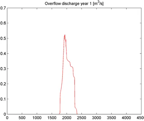
• design and/or expansion of the sewer network in new developments, which has a direct effect on Combined Sewer Overflow (CSO) discharges.
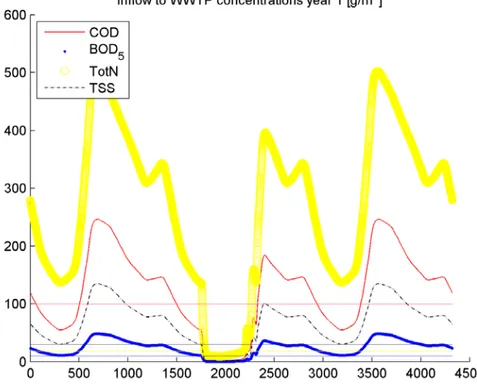
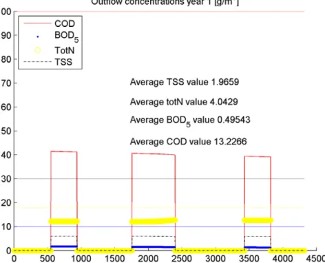
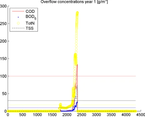
To measure the impact of the underlying relationships between the urban planning scenarios and the surrounding environment, a number of indicators are used as a proxy for its level of ‘stress’. The ambient water quality is represented by a number of possible pollutants including total suspended solid (TSS), biochemical oxygen demand (BOD), chemical oxygen demand (COD), dissolved oxygen (DO), ammonium, nitrogen oxides (NOx), and sulphates. These indicators for instance in the United Kingdom are strictly required with regard to legitimate uses of the water through so-called environmental quality standards (EQSs) based on environmental quality objectives (EQOs).
Generally, existing environmental quality standards have been implemented on the basis of statistically checking the compliance of routine samples against quality criteria (usually 90 or 95 percentile). Meanwhile, the standards have been derived to consider the following variables and
their relationships: pollutant concentration, return period of an event in which that concentration is exceeded and duration of the event.
The impacts of land-use change discussed above relate primarily to the water quality. In a ‘new town’ development, for example, land-use may shift from agricultural, through construction, to industrial or residential.
To achieve a fully dynamic simultaneous simulation in the framework, conversions might be required for the different sets of pollutants, depending on the specific water quality models employed in relevant components. This has been regarded as one of the key problems in the context of integrated modelling of urban wastewater system, and it has a great effect on model performance and reliability. While developing consistent pollutant sets for various sub-systems still has some difficulties, a factors-based conversion method is usually used to convert the different pollutant sets between various sub-systems in the integrated model (Rauch et al., 2002), and this method is also adopted by the WEST simulation tool (Vanhooren et al., 2003), and SYNOPSIS (Schütze, 1998). A similar conversion method is used in this integrated framework to deal with the pollutant sets in the relevant components.
In this Thesis, a framework for modelling the complex relationship between proposed housing development and wastewater pollution incident control is therefore introduced.
The framework looking at the way formal computer models are parameterized by bounding regions in a definite parameter space is introduced. This is the point in the scientific process where socially constructed theory encounters empirical data and a range of data-driven and computational methods are necessary to natural resources management, particularly in respect of water pollution.
1.3 HOW TO CONTEND WITH PROBLEM OF PLANNING
As the EU expands, our ability to integrate diverse cultures without overt “cultural engineering” or suppressing cultural diversity will determine our success in finding peaceful solutions to problems of convergence. Convergence, in this sense, is the process of harmonising local administrative and political institutions with the principles of sound governance established for the
Community as a whole. Convergence invariably creates conflicts of interest on national, regional and local scales and the peaceful enlargement of the EU is probably the biggest challenge Europe has faced since the end of World War II.
Investment in cultural research is clearly necessary, not least because the integrative challenges we face now will soon be dwarfed by those of economic globalisation. Any general lessons we can learn about cultural ecodynamics will obviously be of strategic significance later in the century. Innovation involves work between epistemic communities that may bring physical, life and human scientists into contact with each other and stakeholder communities. It is hampered by clashes about whether boundary judgments - the definitions of systems and problems - are real and universal or expedient and socially constructed.
The project from which this Thesis originates, the Integrative Systems and the Boundary Problem (ISBP) project, will avoid extreme positions and explore ways of managing the tension between these ideas in integrative research. At one end of the spectrum we will study issues in cultural and natural resource management to understand how negotiating new institutional and epistemic boundaries can reduce tension between antagonised stakeholder communities and promote social cohesion. At the other, we will explore the ways of characterising problems in natural science using heuristic data-mining methods to search for boundary judgments that help make problems tractable. It is nowadays clear that effective land use planning cannot address the analysis of physical and human processes in isolation, but must rather focus on their interconnections and treat the land system in a holistic approach.
Increasingly over the last 15 years, various types of integrated models have been successfully developed to support policy making in addressing specific problems related to the changing land-use and land-cover pattern and their effect on the land system. Building upon the conceptualization proposed by Mather (2006), integrated models address the relations between human land-use activities and environmental change and they can be represented as human-environment systems with socio-economic as well as ecological and biophysical components as sub-systems.
Traditionally, the key driver of the integrated models proposed so far has been the component simulating the changing land-use and land-cover pattern, with problem domain varying from urbanization (e.g. Couclelis, 1997; Clarke et al., 1997), management of coastal zones (e.g. de Kock et al., 2001) and deforestation (e.g. Pontius Jr. et al., 2001), and with spatial scale ranging from local to global. From a conceptual point of view, this component integrates two different types of
processes: those that pertain to the decision making and that ultimately alter the land system (e.g. urbanisation, deforestation, infrastructure provision, etc.), and those driving, or underpinning, the decision making process (e.g. socioeconomic structure, demographic change, technology, policy, etc.). Geist and Lambin (2002) refer to the former type as the proximate processes or causes, which usually operate at a local level, whereas the latter is called “underlying cause” and can operate at the local level but more often at a global scale.
The level of detail of the implementations describing proximate and underlying causes varies greatly over the models proposed (Heistermann et al., 2006), with a representation of the underlying principles that can either be empirical-statistical, also referred to as inductive (.e.g. multivariate regression analysis to link socioeconomic variables to land-use suitability measure), or economic and process-based, also known as deductive. The land-use component usually sets the spatial resolution of the model, i.e. the scale at which both decision making and physical processes are described.
Different types of biophysical models have been coupled with a land-use component to simulate its interconnections with, and ultimately effect upon, the environmental system. Agricultural trade models (van Tongeren et al., 2001; Balkhausen and Banse, 2004), economic models of deforestation (Angelsen and Kaimowitz, 1999) and traffic and transportation models (Miyamoto et al., 1996) are only a few examples. Depending upon the flexibility of the tools implemented and their link to the specific domain for which they were originally developed, authors have referred to their models either as integrated models or integrated frameworks, although a clear definition is still lacking. Various reviews exist of land-system models, which, however, do not explicitly differentiate between land-use models and integrated models. Verburg et al. (2004) discuss models according to driving forces, spatial interaction or level of integration. Verburg et al. (2006a) and Agarwal et al. (2002) use model characteristics like spatial versus non spatial or dynamic versus static as discriminators. Parker et al. (2002) concentrate on multi-agent systems as opposed to cellular automata (CA), which are the most widely used approaches.
Clearly, a unifying classification method does not exist. However, features that are common to all integrated models/frameworks by definitions are:
• The coupling of models describing both human and biophysical processes (i.e. what are the processes described?);
• The relation describing the interconnections between the models (i.e. what is the level of integration?);
• The tools for supporting decision making (i.e. what type of analysis is automatically provided?).
Focusing on the features outlined above, the chapter 2 provides a critical review of the most recent developments of integrated models/frameworks presented in the scientific literature, with the view of highlighting strengths, limitations and therefore motivating the research effort herein presented.
1.4 TARGETS
The main objective of this Thesis is the full description and testing of the integrated framework made by a land use change model, a sewage system simulator and a wastewater treatment plant simulator. This objective will describes the motivation, the rational and implementation details of a modeling framework, SSDIM, which is an effort to bridge the gap of integrated models for decision making in urban planning.
However, it is possible to define further second level objectives, which will be the focus of each chapter. These targets can be summarized as:
1. State-of-the-art: literature review, legal background and methodology. 2. Description of the framework developed.
3. Application on a case study.
1.5 LAYOUT
The Thesis will be divided into eight chapters(the present introduction is the first chapter).In the first part of the Thesis (Chapters 1 and 2) the setting and motivation for the framework proposed and an extensive critical review of the studies available in literature are discussed.
The second part of the Thesis (Chapters 3 and 4) presents the elements of the models implemented: in particular, both the conceptual representation and the implementation details are discussed in depth. The methodology for the complex model development can be divided into two parts: the earlier stage consists in the identification of the model components which can simulate single events concurring to the description of the complex system, the latter stage which consists in the integration of the single components into a common framework.
Finally in the latter part of the Thesis (Chapters 5 and 6), an application of the framework developed to a real world environmental problem and the results of the application of the framework to a pilot study will be described.
The network considered for the case study is situated in the city of Mauchline, a small town located in the county of East Ayrshire, in south west of Scotland.
The results show that the population growth rate has obvious effects on water quality. However, these effects do not compromise the functionality of the sewage system and of the treatment plants. An interesting effect seems to be caused by the rainfall event, but in this case the feedback could be the construction of a storage tank which limits the peak inflow to the treatment plant.
Such strategy applied to different planning assumptions may suggest effective mitigation options for sustainable land use planners to reduce the impact of new developments and thus achieve a better water environment.
2 LITERATURE REVIEW
2.1 INTEGRATION OF COMPLEX PROBLEM
CLUE (Conversion of Land Use and its Effects) (Verburg et al., 1999a) and the subsequent CLUE-S (Verburg et al., 2002) are modeling frameworks for quantitative multi-scale analysis of actual land-use and the modelling of land-use change scenarios. CLUE is a two-step model. First the suitability values of grid cells are evaluated based on statistical models that relate socio-economic, geographical and biophysical driving factors with land-use patterns. Then dynamic allocation of resources is undertaken between competing cells based on their suitability values and on national level demand changes for each land-use type (CLUE-S integrate this step with transition rules for each land-use type). Although CLUE/-S only provides land-use modeling capabilities (the former with a spatial resolution of 7×7km and 32×32km square grid, and the latter with a 1x1km grid), they have been integrated with other biophysical models to address specific problems. Verburg and van der Goon (2001) coupled CLUE with empirical emission factor models (IPCC, 1997) for the analysis of the effects of changes in rice cultivation area and livestock management on methane emissions for China. Priess et al. (2001) coupled a CLUE model (with a spatial resolution of 9×9 km) with the NUTMON tool (Smaling and Fresco, 1993) for the assessment of soil nutrient balances in tropical agricultural systems. NUTMON is a nutrient balance model to relate nutrient inputs such as fertilizer application and biological fixation to output fluxes in (among others) harvested products, crop residues and by gaseous losses. Verburg (2006) integrated the CLUE-S model to the process based LAPSUS model (Schoorl et al., 2004) in order to calculate the impact of land-use change on erosion erosion/sedimentation processes, and applied it to a region in Southern Spain. If the coupling CLUE-NUTMON is an open loop, the integration with LAPSUS is greater. In fact, erosion processes triggered by agricultural management are related to soil depth which in turn influences the suitability of grid-cells for agricultural purposes. All these studies provide limited functionalities for undertaking quantitative analysis and automatic planning and they have been typically employed to perform what-if scenarios.
GEONAMICA is a commercial application framework for constructing integrated models of the land system (supporting an hierarchical spatial representation, from macro/regional levels to grids, with a resolution typically ranging from 100×100 m to 500×500 m ) based on the CA conceptualisation presented by White and Engelen (1997). The human sub-system consists of three models components: (1) water management, (2) land-use, and (3) crop choice and profit. The first component calculates water use of different land-use activities. The land-use model (Engelen et al., 1997) simulates land-use change on two different scale levels. On the regional level (macro-level), it calculates the land demands for different economic sectors such as agriculture, forestry and industry (de Kock et al., 2001) by representing a mixture of underlying causes such as demography and market mechanisms, according to Geist and Lambin (2002). These land demands are then spatially allocated to the grid level (micro-level) through the constraint cellular automata approach introduced by White and Engelen (1997) taking into account the cell’s suitability for different types of land-use, its spatial neighbourhood, zoning restrictions and accessibility of transport infrastructures. The crop choice and profit model then determines the best suited crop type for each cell that has been previously classified as agricultural use. This is done by portraying the decision making process on level of individual farmers, providing crop prices are variables. The environmental sub-model consists of a climate and weather model, a hydrology and soil model and a vegetation model. All these three models describe the corresponding physical processes at the grid level with different temporal resolution. The climate and weather model interpolate data from meteorological stations and general circulation models to the grid level. Interception, runoff, evapotranspiration, infiltration, soil moisture, aquifer recharge, river flow and transmission losses are implemented in the hydrology model, which processes this information, along with soil characteristics such as texture and thickness, to simulate soil erosion and sedimentation as well as soil and aquifer salinity. The vegetation model consists of two elements: the plant growth element determining structural components of plants and crop yields, and the natural vegetation element for calculating succession processes and the response of natural vegetation to exogenous perturbation through a rule-based approach. The human and environmental subsystems are highly integrated through numerous dynamic feedback mechanisms. GEONAMICA has been extensively used to develop decision support systems (DSS) and policy support systems (PSS). Examples are MODULUS (MODULUS, 2000; Oxley et al., 2004), which addresses physical, economic and social aspects of land degradation in the Mediterranean region, RamCo (de Kock et al., 2001), for coastal zone management in South Sulawesi in Indonesia, and MedAction for the support of
planning and policy making in the fields of land degradation, desertification, water management and sustainable farming in Mediterranean watersheds (van Delden et al., 2007).
IMAGE 2.4 (Integrated Model to Assess the Global Environment) (MNP, 2006), (Alcamo et al., 1998) is a general dynamic integrated assessment model for the simulation at the global scale (a major scale with 24 world regions and a minor scale of approximately 50×50 km grid cells) of major societal and environmental processes of the Earth System and their feedbacks over a long temporal scale (usually 100 years). It has three components forming the human/decision making subsystem: an energy supply and demand model for each world region, a consumption and trade of agricultural products model and a land-use change model based on spatial allocation on the grid level. The environment sub-system consists of model components for terrestrial vegetation, terrestrial carbon, nutrient cycles, and biodiversity. All these components operate on grid level and are highly integrated both dynamically and across scales. IMAGE has been successfully applied in isolation to study the effect on the global scale of various processes, from land-use emissions (Strengers et al., 2004) as well as impacts of land-use change on ecosystems and the environment (Scenarios Working Group, 2005; Eickhout et al., 2006), and coupled with specific process models for various analysis, ranging from bio-energy potentials (Hoogwijk et al., 2005; de Vries et al., 2007) to the assessment of the impacts of land-use change on the carbon cycle (Sitch et al., 2003; Müller et al., 2007). IMAGE does not provide DSS integrated capabilities and it is usually used in large assessment studies for the analysis of long term strategic scenarios.
PLM (Patuxent Landscape Model) (Voinov et al., 1999a; Costanza et al., 2002) is an integrated framework for supporting water quality management on the watershed level (from 200×200 m up to 1×1 km spatial resolution) by simulating its relationship with nutrient loading resulting from changing land-use. The human sub-system is described by a Markov Chain-based economic model which computes the probability of conversion from agriculture or forest to residential land use based on factors like distance to public infrastructure and proximity to other land-use types as well as on historical land conversion decisions and land conversion costs. These probabilities are combined with assumptions of regional growth pressure for settlement development to generate the actual quantity of land-use change. The environment sub-system consists in an ecological component, which is organised in a grid level model and a spatial model. The former simulates ecological processes like forest, cropland, grassland, urban and open water within each grid cell using three components: the hydrology component (computing cell vertical water fluxes, including infiltration, transpiration and evaporation, the nutrient component, simulating the dynamics of
phosphorus and nitrogen, and the he macrophyte component simulating processes of plant growth according to temperature, nutrient levels and water availability. The spatial model then computes the inter-cell horizontal fluxes previously generated at the grid level. The PLM model was originally developed for the Patuxent River watershed in the State of Maryland in the U.S.
ITE2M (Integrated Tool for Ecological and Economic Modelling) (Fohrer et al., 2002; Frede et al., 2002; Reiher et al., 2006) was developed to simulate the influence of changing land-use policy on environmental services like economic output, water balance and biodiversity. ITE2M operates at different scales that are specific to the model components, ranging from a 25×25 m grid over fields to sub-catchment level. The human sub-system is modeled by the models ProLand (Kuhlmann et al., 2002) and CHOICE (Borresch and Weinmann, 2006). The former simulates allocation of land-use systems dependent on legal and economic boundary conditions, and environmental factors. The latter consists of two parts: the first evaluates landscape functions based on an economic cost-benefit approach, while the second calculates price effects of agricultural policies. Processes of the environment sub-system are represented by the yield estimation module of ProLand and by different models used for the assessment of environmental services, including hydrology (SWAT, Soil Water Assessment Tool) (Arnold et al., 1993), biodiversity (cellular automata model ANIMO for habitat specific species numbers and botanical species richness) (Frede et al., 2002) and soil pollution. Its first application was the “Lahn-Dill Bergland” region (1200 km2) in Germany. In terms of inter-components integration, the linkages are straight forward and do not account for feedback loops. Similarly to the other models/frameworks described, ITE2M does not provide automatically supporting decision making.
Various other integrated models exist whose primary focus is supporting a better understanding of the effects of land-use and agricultural policy change on various aspects of the land systems. Major examples are SITE, which also comprises an automatic calibration module based on genetic algorithms (Priess et al., 2007) and LANDSHIFT (Alcamo and Schaldach, 2006).
Marquez and Smith (1999) reported a group effort by the CSIRO scientists that developed an integrated framework for evaluating the coupled effects of land use, transport and airshed process models in urban environment air quality. Two existing models, the land use–transport–environment (LUTE) from CSIRO BCE and the meteorological and photochemical model from CSIRO Atmospheric Research were linked through an effective interface (STEAM) that supported data transfer from different format and enabled extensive automatic calibration. LUTE supplies basic
urban development scenarios consisting of land use, and associated urban infrastructure and activities, subdivided into homogeneous zones, and the population allocated to each activity within each zone for a given time period. A transportation gravity model is then applied to these land use scenarios to forecast the level of congestion in the road network. The level of congestion on each link, along with associated scenario information, provides the input to the emissions interface which calculates the distribution of emissions based on parameters provided by the Victorian Environment Protection Authority (EPAV). Four sources of emissions were considered:
1. link-based emissions come from mobile sources,
2. area-based sources generated by urban activities occurring over wide areas of land, 3. point sources individual sites and
4. biogenic sources from plants and vegetation.
These emissions are subsequently interpolated at grid level to be elaborated by the airshed model which, using the forecast meteorological conditions from the meteorological component track the movement of contaminants and calculate the rate of chemical reaction that lead to the formation of photochemical smog and secondary aerosols.
Irving and Moncrieff (2004) presented a modeling framework developed by the New Zealand minister of transport for integrated assessment of the effects of the variation of transport system (infrastructure and activity) on environmental indicators (air quality, and greenhouse gasses emissions). A fleet vehicle model generates NZ specific emission rates based on international data on pollutant generation rates by vehicle technology and on New Zealand specific data on exhaust emissions, fuel use, component wear, driving patterns, road and traffic types. The framework can accommodate for other process specific models to generate other spatially referenced emission rates or loading, which are then fed to an environmental capacity analysis component which assesses the stress level of the receiving environment according to sustainability thresholds. The level of integration of the various components is quite low and there is not an explicit land-use component that can support urban planning with respect to different activities.
Various others integrated modes/framework exist for the urban domain and a good review is given in (Kapelan et al., 2006) where the authors focus on providing a classification of existing decision support tools for sustainable urban planning based on a set of criteria accounting for quantitative and qualitative analysis, stakeholder involvement and participatory decision making.
In spite of the large number of successful research projects and tools developed, today there is a distinct lack of methods and systems that reconcile land-use change, traffic and water infrastructure in an integrated network of processes that enable the analysis of the effect of urban plans on water and air pollution to support decision making for sustainable urban development.
2.2 LEGAL BACKGROUND
The preservation of water quality is highly affected in urban areas by continuous as intermittent immissions, it is necessary to adopt measures to intercept and treat these polluted flows. In particular during rain events, water quality is affected by Combined Sewer Overflow (CSO) activation. Built in order to protect the sewer system and the wastewater treatment plant by increased flows due to heavy rains, CSOs divert excess flows to the receiving water body. On the basis of several scientific papers, and of direct evidences as well, that demonstrate the detrimental effect of CSOs discharges, also the legislative framework moved towards a stream standard point of view.
The Water Framework Directive is the most substantial piece of water legislation ever produced by the European Commission, and will provide the major driver for achieving sustainable management of water in the UK and other Member States for many years to come.
It requires that all inland and coastal waters within defined river basin districts must reach at least good status by 2015 and defines how this should be achieved through the establishment of environmental objectives and ecological targets for surface waters. The result will be a healthy water environment achieved by taking due account of environmental, economic and social considerations.
The European Union Water Framework Directive (WFD), adopted in 2000, laid the foundation for a modern, holistic and ambitious water policy for the European Union and defined a clear implementation calendar to achieve its objectives, with intermediate deadlines for the achievement of specific tasks, among them:
1. December 2003: transposition of the WFD into national law (article 24), identification of river basin districts and set up of administrative arrangements (article 3).
2. December 2004: pressure and impact analysis of river basin districts, and economic analysis of water uses (article 5).
3. December 2006: establishment of the monitoring programmes for the assessment of water status (article 8).
4. December 2008: publication of the draft river basin management plans for consultation (article 14).
5. December 2009: adoption of the river basin management plans (article 13). 6. December 2012: programme of measures operational at the latest (article 11).
7. December 2015: achievement of good status for surface and groundwater (article 4) and first update of the river basin management plan
The Communication from the Commission to the European Parliament and the Council “Towards sustainable water management in the European Union - First stage in the implementation of the Water Framework Directive 2000/60/EC” and the accompanying Staff Working Document gave, in March 2007, an overview of the aims of the Directive and summarised the results of the implementation of the first two steps identified above.
This Report and the accompanying Commission Staff Working Document responds to WFD Article 18(3) which requires the Commission to publish a report on the progress of implementation of the WFD related to Article 8 on monitoring of water status. This report is based on the information submitted by Member States in accordance with WFD article 15(2), due on 22 March 2007.
The Water Framework Directive (EU/69/2000) sets new goals for receiving water quality, and groundwater as well, through an integrated immission/emissions phylosophy, in which emission limits are associated with effluent standards, based on the receiving water characteristics and their specific use. For surface waters the objective is that of a “good” ecological and chemical quality status. A surface water is defined as of good ecological quality if there is only slight departure from the biological community that would be expected in conditions of minimal anthropogenic impact. Each Member State authority is responsible for preparing and implementing a River Basin Management Plan to achieve the good ecological quality, and comply with Water Framework Directive (WFD) requirements. In order to cope with WFD targets, and thus to improve urban receiving water quality, a CSOs control strategy need to be implemented. Temporarily storing the
overflow (or at least part of it) into tanks and treating it in the waste water treatment plant, after the end of the storm, showed good results in reducing total pollutant mass spilled into the receiving river.
Council Directive 91/271/EEC concerning urban waste water treatment was adopted on 21 May 1991 to protect the water environment from the adverse effects of discharges of urban waste water and from certain industrial discharges. On 27 February 1998 the Commission issued Directive 98/15/EC amending Directive 91/271/EEC to clarify the requirements of the Directive in relation to discharges from urban waste water treatment plants to sensitive areas which are subject to eutrophication.
The Urban Waste Water Directive, full title Council Directive 91/271/EEC of 21 May 1991 concerning urban wastewater treatment is a European Union directive concerning the "collection, treatment and discharge of urban waste water and the treatment and discharge of waste water from certain industrial sectors". The directive was adopted on 21 May 1991. Its stated objective is "to protect the environment from the adverse effects of urban waste water discharges and discharges from certain industrial sectors".
The directive requires the collection and treatment of waste water in agglomerations with a population of over 2000, and more advanced treatment in agglomerations with a population greater than 10,000 in sensitive areas.
Sensitive areas, within the meaning of the directive, include "freshwater bodies, estuaries and coastal waters which are eutrophic or which may become eutrophic if protective action is not taken"; "surface freshwaters intended for the abstraction of drinking water which contain or are likely to contain more than 50 mg/l of nitrates"; areas where further treatment is necessary to comply with other directives, such as the directives on fish waters, on bathing waters, on shellfish waters, on the conservation of wild birds and natural habitats, etc. The directive also provides for a derogation for areas designated as "less sensitive" and such derogations were approved for areas in Portugal.
By 31 December 1998 member states were required to ensure that wastewater treatment facilities were available for all agglomerations with a population of over 10,000 where the effluent was being discharged into a sensitive area. By 31 December 1998 member states were required to ensure that wastewater treatment facilities were provided for all agglomerations with a population of over 15,000, which discharged their effluent into a so called "normal areas" and biodegradable
wastewater produced by plants of the food-processing sectors listed in the directive, and which discharged directly into receiving water bodies, fulfilled certain conditions.
By 31 December 2005 member states were required to provide collecting and treatment systems in all agglomerations with a population between 2000 and 10000 where the effluent is discharged into a sensitive area, and in all agglomerations with a population of 10,000 to 15,000 where the effluent is not discharged into such an area.
In 2004, Commission reported on implementation by the member states, the Commission noted that some member states, in particular France and Spain, were late in providing the required information, and infringement procedures had been initiated.
The report further mentioned a number of concerns regarding implementation in several countries, in particular the United Kingdom's interpretation and implementation of the directive about to the catchment areas of sensitive areas. According to the 2004 report, most member states planned to achieve conformity with the Directive by 2005 or 2008 at the latest.
The Urban Waste Water Directive marked a shift from legislation aimed at end-use standards to stricter legislation aimed at regulating water quality at the source. The directive applied both to domestic wastewater and to wastewater from industrial sectors, both of which account for much of the pollution. It also demonstrated the increasingly detailed nature of European Union legislation and resulted in significant costs in many member states.
Many years after the directive was adopted, considerable variations remained in the provision of sewage treatment in the different member states.
Numerous directives in the field of water supply and wastewater treatment have been exempted by the European Union (EU). Until recently, such abundance of cause-related regulations has been considered to be sufficient to manage water bodies from an environmental point of view. However, increasing problems related to water quantity and quality led to the development of an integrated approach for water management systems, including all water-related impacts (Saurer et al., 2000). These efforts resulted in the amendment of the Water Framework Directive (WFD) (EU/2000/60/EC-WFD 2000) with the main objectives being the following (Holzwarth, 2002; Wiedemair, 2003):
1. Achievement of a ‘‘good ecological status’’ in all water bodies of the European Union until 2015 by applying an integrated approach for water management. Avoidance of deterioration of the present status of the water bodies.
2. Establishment of a coordinated river basin management within the EU and across the national borders (e.g., for the Danube, Rhine, Elbe, etc.).
3. Assigning a full costs recovery scheme to water supply and wastewater services (including environmental and resource costs). The polluter-pays principle has to be applied.
4. Preparation of periodically updated river basin management plans by incorporating all stakeholders.
5. Combined emission–water quality-based approach for the decrease of pollution from both point and diffuse sources.
6. Reduction (and finally the elimination) of emissions of single hazardous substances, according to a specified list of priority substances.
7. Periodically updated, legally binding programs for measures and monitoring of water quality and the development of management programs for control and planning purpose. Because EU directives are not executable directly, they need to be translated into national legislation. Therefore, the factual implementation of the WFD is undertaken in the EU member states individually, with each of them being required to define its own standards and methods following the main objectives. The first step of the implementation process has been already accomplished with the adaptation of the member states national water legislations by the end of 2003. According to these targets, the WFD is among the most progressive water-related regulations worldwide.
3 DESCRIPTION OF THE MODEL
3.1 INTRODUCTION
The housing development and land use change model (LUC) allow the housing densities, types, locations, etc., to be characterized and projected forward in time. LUC is multi-agent based (Hercog and Fogarty, 2001) and simulates the land planning, urban growth and evolution processes over a given planning horizon. This model is a cellular automata-based model (Hercog and Fogarty, 2001), whereas the development is determined according to some transition rules (Fu et al., 2008). The implemented rules are: driven by population growth, the model distributes the population spatially over a predefined development area and provides the land use type, number of houses, and number of people for each residential land use cell. The cell-based information is transformed and linked to the node-based sewage network.
The urban drainage model (UDM) allows the accounting of total water budget within the study area. UDM is based on a robust and broadly used solver, the EPA storm water management model (SWMM) (Lager and Smith, 1974; Huber and Dickinson, 1988). SWMM tracks the quantity and quality of runoff generated within each subcatchment, and the flow rate, flow depth and quality of water in each pipe and channel during a simulation period comprised of multiple time steps (Rossman, 2005).
The wastewater treatment plant model (WWTP) is used to model the flow hydraulics and system performance in terms of dry weather flows, wet weather flows and sedimentation. It is based on that developed by the IWA Task Group on benchmarking of control strategies (BCS) for wastewater treatment plants (Copp, 2002). WWTP simulates the municipal facility, which treats the wastewaters from the existing sewage network. The activated sludge model No. 1 (ASM1) is used to simulate the biological processes in the reactors (Henze et al., 1986) and the secondary settler is modelled as a non-reactive 10-layer process using a double exponential settling velocity model developed by Takacs et al. (1991).
The methodology for the complex model development can be divided into two parts: the earlier stage consists in the identification of the model components which can simulate single events concurring to the description of the complex system, the latter stage which consists in the integration of the single components into a common framework. In this chapter a description of the single model components is given.
3.2 LAND USE CHANGE MODEL
The land use change model (LUC) represents the land planning and evolution process and is used to simulate the urban growth over a given planning horizon.
This model is a cellular automata-based model (Hercog and Fogarty, 2001), in which the development state of each cell is determined in terms of its own state and the states of its nearby neighbors at the previous time step, according to some transition rules (Fu et al., 2008).
A few types of transition rules have been implemented, and new rules can be easily integrated to allow for the analysis of the impact of different expansion patterns on the water quality. Driven by population growth, the model distributes the population spatially over a predefined development area according to the transition rules chosen and provides the land use type, number of houses and number of people for each residential land use cell.
The cell-based information, see Figure 3-1, is transformed and linked to the node-based sewage network in the spatial aggregation model according to the geographic information of the catchment and the topology of the newly designed/expanded network.