Alma Mater Studiorum – Università di Bologna
DOTTORATO DI RICERCA IN
GEOFISICA
Ciclo XXVIII
Settore Concorsuale di afferenza: ___04/A4____
Settore Scientifico disciplinare:__GEO/10______
TITOLO TESI
Stress Field and Seismicity at Campi Flegrei Caldera
Presentata da: Elena Cristiano
Coordinatore Dottorato
Relatore
Pinardi Nadia
Luca D’Auria
_______________________
_________________
Index
Abstract
Chapter I - Framework of the Area
1.1 Campanian Plane
1.2 Caldera generation
1.2.1 Super Eruptions
1.3 Campi flegrei Caldera
1.3.1
Structure of Campi Flegrei Caldera
1.3.2 Other caldera
1.3.3 Campi Flegrei caldera characteristics and precursors
Chapter II - Analysis of seismic data
2.1 Seismic data related to volcanic area
2.2 Campi Flegrei caldera seismicity
2.2.1 Details about the 2005-2006 uplift
2.3 Data Analysis
2.3.1 Picking of the earthquakes 2.3.2 Velocity model
2.4 Absolute and Relative locations of the earthquakes
2.4.1 Relative location & Double difference Alghoritm.
2.5 Focal mechanisms Solution
2.5.1 Results
2.6 1970-1973 Analysis
Chapter III – Stress and Focal mechanism inversion
3.1 General overview of the stress
3.1.1 Pressure types
3.1.2 Mohr
3.1.3 Mohr-Coulomb Criterion
3.1.4 Coulomb – Navier criterion
3.1.5 Optimal principal stress orientation
3.1.6 Anderson’s criterion
3.3 Determination of stress
3.4 Stress Inversion
3.5 Inversion of Focal Mechanisms
3.5.1 Analytical method
3.5.2 Graphical Approach - RDM
3.5.2.1 RDM modified (D’Auria et al., 2014)
3.5.3 Graphical Approach – MIM
3.5.3.1 MIM software & Results
Chapter IV- Analysis of ground deformation data & Joint
Inversion
4.1 Bradysism
4.1.1 Similarity between 1970-1972 and 1982-1984
4.2 “1982-84” Bradyseismic crisis
4.2.1 Other episods of unrest
4.3 Leveling dataset & Analysis
4.4
Inverse method
4.4.2 Model estimation 4.4.3 Deformation Model
4.5 Joint inversion
4.5.1
Campi Flegrei caldera joint inversionChapter V – Seismogenesis & Discussions
5.1 Hydrothermal system of Campi flegrei Caldera
5.2 Pore pressure Analysis
5.3 Thermo – fluid simulations (MUFITS)
5.4 The Campi Flegrei caldera Model
5.5 Simulations of the Hydrothermal system
5.5.1 Results
5.6 Bradyseismic crisis simulations
5.6.1 Results
5.7 Discussions & Conclusions
Bibliography
Abstract
Aim of this work is the study of the stress field in the Campi Flegrei caldera during the bradyseismic crisis of 1982-1984.
Campi Flegrei caldera activity consist of secular ground movements, generally of subsidence, with rates of the order of 1 m per century (De Natale et al. 2001), and rapid unrest episodes, that in the recent time, just in one occasion culminate with eruptions, in 1538.
During period of uplift, the caldera is interested by phenomena of seismicity characterized by a determined spatial distribution.
In the first part of the work has been analysed old cretaceous and digital seismic datasets relative to 70th years, and the bradyseismic crisis of 1982-1984 where has been recorded the earthquakes
linked to uplifts that interested Campi flegrei caldera during 1969-72 and 1982-84.
The seismicity dataset has been used to made some analysis as location and focal mechanisms generation. The focal mechanisms are than analysed using two software to determine the principal state of stress that was predominant in that period.
Then, starting from ground deformation data, relative to 1100 optical levelling measure done during the bradyseismic crisis, has been use the inversion method to modelling the source of the deformation. Has been used many model as the Mogi model, the penny shaped-crack, and the rectangular crack of Okada.
Consequently, a joint inversion was applicate on ground deformation data and seismicity together to better understand the dynamic of the stress in the area. Using this type of inversion, the aim was to know if existed a regional stress field in the area during bradyseismic crisis and if was dominant
on the local stress. It was possible estimate also if was present a “memory” in the system Campi Flegrei of precedent episode of unrest.
In the last part of the work, has been determined the excess of pore pressure in the Flegrean area, using focal mechanisms to study the influence of fluid pore pressure on change in the Coulomb stress of the area.
Has been used the Coulomb-Navier criterion and Terakawa method (2010) to estimate the excess of pore pressure.
Finally, in order to evaluate the reliability of the calculated pore pressures, was done thermo-fluid dynamic simulation and analysed the hydrothermal system of Campi Flegrei caldera. So, has been performed a series of simulation thermo-fluid dynamic injecting a flow in the system varying temperature, pressure and injection rate to model the Campi Flegrei caldera during the unrest.
Chapter I - Framework of the Area
1.1 Campanian Plane
Italian Volcanism is linked to geodynamics of Tyrrhenian area, where a marked lithospheric thinning is observed (Wang et al., 1989 and references therein). This area is characterized by active tectonic linked to convergence of Euroasiatic and African plates, on what limits are located Italian volcanoes. Magma comes from the Earth mantel and interacts with the Earth crust. For Mt.Etna, Vesuvius and Campi Flegrei, the magma source is the mantel and the magma is generated for sucking of asthenospheric material from African Plate (Gvritzaman & Nur, 1999), or enriched of fluids or melt released by underlying oceanic slab(De Natale et al., E. Sc.Rev,2006). Junction of three faults system explains the magma rising through the Earth crust. Magma generation may be linked with slab withdrawal(Fig.1).
Figure 1 – (Deino et al., 2004) Campanian Plain
Tirrenian sea is an extensional neogenic basin generate during the formation of Appenninc chain and accompanies the anticlockwise rotation of Italian peninsula.
- From Tortonian to Pliocene period: N-S and NNW-SSE Normal faults characterized initial extensional phases.
- Plio-quaternary period: NW-SE,NE-SW interested Tirrenic edge.
- Quaternary: NW-SE and NE-SW direct fault determined subsidence sectors that is the case of Campanian plate delimited at the North- Northwest by the morpho-structural high of Massico Monte and to south-east by Monti Lattari that constitute the Penisola Sorrentina. Along the coastline into the Campanian plane, there are the volcanic morpho-structures of Somma-Vesuvius complex and Campi Flegrei policrateric district.
According with Scandone (1991), Campanian volcanoes are in a depressive zone: a graben bordered by Mesozoic carbonate platform, subject to sinking in the quaternary period. Under this depression, the platform deep is between 1 to 4-5 Km. Its origin is linked to continental crust thinning due to anticlockwise rotation of the Italian peninsula and in the same time due to the opening of Tirrenian sea. This movement involved carbonatic platform subsidence along the tirrenian coast (Scandone, 1979).
Then 1 Ma years ago, started a potassic volcanic intense phase in the zones of Campania and Rome. The stretching of the crust induced mantle uplift in the central zone of the tyrrhenian sea, which thickness seems to be from 5 to 10Km. Moho depth increases under Apennine chain while in certain zones is very shallow, as under Campi Flegrei where is 15 km due to upwelling ( Ferrucci et al, 1989).
The southern Apennine chain is a Neogene thrust belt built up for the continental collision between the Corsica-Sardinia microplate and the African plate (Zuppetta,1991). Since the Upper Pliocene, regional extension has broken the Southern Apennine chain in several blocks, which led horst and graben development and formation of the Campanian plane. Its structure is controlled by two major normal faults system that have had a major influence on the location, within the plain of volcanic
fields as Roccamonfina, Campi Flegrei and Vesuvius. The recent seismic activity and the evolution of Tyrrhenian area (Scandone,1979) shows an extensional tectonic regime.
In accord with Troise et al., (1998) the actual stress state of Apennine chain, deduced from focal mechanisms of bigger earthquakes, is extensional in the central and south part, instead is compressional in the north part of the chain. These two states seem to be due to anticlockwise rotation of the Adriatic plate around a pole located in the chain part bordering the Padanian plate where were observed moderate earthquakes thrust type.
On the basis of historical seismicity, it’s possible divide the chain in various seismotectonics domains each one characterized by a certain style of seismicity and tectonic characteristics. Many of this domains, in the most part for the central segments and to the south of the chain, produced destructive earthquakes with magnitude up to 7. Every seismically active domain is characterized by normal fault, generally with strike in the direction of the chain. Other areas have low magnitude earthquake with occurrence of swarms. These areas are characterized by complex faulting mechanisms not easily linked to normal extension of the chain.
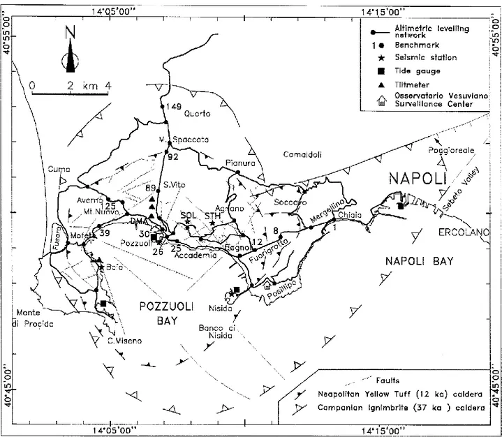
The Napolitan – Phlegrean volcanic area is the consequence of alternating constructive and destructive volcanic and volcano-tectonic events. This area includes either a submerged and subaerial part in which lying Campi Flegrei and the city of Naples. The central part of Campi Flegrei is characterized by many tuff-rings and tuff-cones. To the north of Naples there are some plains that are bordered by steep cliffs. To the East there is a NE-SW elongated hill, bordered by steep scarp to the west and a dipping coast to the east and extends north-eastward into a chain of morphological heights (Fig, 2) (Orsi,1996).
Figure 2 – Campi Flegrei caldera (Orsi et al., 1999).
1.2 Caldera generation
The simplest way to define a caldera is: a large depression due to sinking of a building volcanic part into the magma chamber after it was emptied. Macdonald (1972) define them as circular or elliptical volcanic depression with diameter major or equal to 1.6 Km. structures with smaller diameter are called pit craters.
Like other volcanic phenomena, caldera formation derives from a long process that involve generation of magma at depth, its ascent at shallower depth, differentiation and eruption from the earth surface. It’s associated to most magma type from basalts to more evolved magma. Respect to the other volcanic process, caldera-forming eruption are rare because they require very specific stress and thermodynamic conditions for collapse to occur (Druitt and Sparks, 1984; Gudmundsson,1998, Martì et al., 2000) .
Calderization for many volcano fields with elliptical shape is due to pressure from the basis that normally is relative to magma accumulation that push forming a dome in the area bigger than the magmatic chamber. This situation generates calderization of the shallow crust.
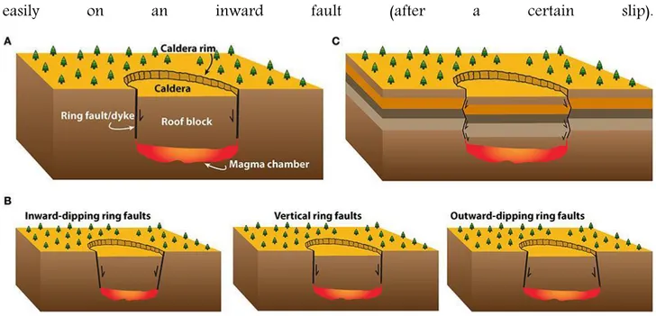
Caldera and relative collapse are very common on the earth. Caldera structures are generally similar but with variable dimensions. The caldera with the biggest dimension has a diameter of 80 Km, the medium diameter for associated caldera is 6 Km. Some calderas are associated to regional fault, the most part of collapses however, happen along ring-faults associated to crustal magmatic chamber. The start of faulting and movement depend on local stresses which are controlled by load condition and mechanical proprieties of rocks and structures that constitute the volcano (Gudmudsson, 2008 ).
In particular, a ring fault is a shear fracture that is different respect the fault that generated earthquake. First of all, ring faults are closed fault with an elliptical shape, while faults that generate earthquakes are generally lines. More, the movement along the faults for generate collapse is bigger than for earthquake; in fact, large earthquakes may reach 10/20 meters of movement. Calderic collapse may reach even Km. For both of them, the movement is driven by shear stresses concentrated on fault plane. Another difference regards the fault inclination: ring faults are dip-slip faults. Dip-dip-slip of earthquake normally are inclined of 45-75°, while many ring faults are near vertical. Because is improbable that the principal angle between direction of maximum principal
stress and fault plane differs for two fault types, this observation indicated that there is a fundamental difference between local stress field that control these different faults and different orientations of principal stress at the moment of fault formation and movement ( Gudmudsson, 2008 ).
Many ring faults are formed from local stresses around the crustal magmatic chamber. The general mechanism of formation is unclear but there are many clear aspects. It’s know that these faults are shear fracture and their starting and develop depends on the state of stress of the host rock. The state of stress in a volcano is partially controlled by mechanical propriety of their rock units and structures as existent contacts, faults and joints. Partially, volcanic stresses are controlled by load conditions at which the volcano is subject. In particular, the geometry and magma pressure into the associated chamber and the tectonic regime into which is located the chamber.
Ring faults are generally concentric and their inclination is outward from the caldera centre. Many of them are occupied by dikes many of which are inward and vertical.
All the models made to explain the formation of ring faults and calderic collapse are concordant on the fact that the movement along the ring fault is relative to the existence of a crustal magmatic chamber in which the calderic block subside.
Many calderas are filled by lava fluxes from their edges. These fluxes indicated that under the caldera exists an active magmatic chamber and that the caldera is able to sustain an overload on the edges without sliping (Gudmudsson, 2008).
An outward fault that goes into a shallow magma chamber, tent to slip while increases the thick of lava inside the caldera cause to the lava load, the extension and the friction loss, between the calderic block subsiding and the wall of the ring fault (Fig. 3). For an inward fault the load is concentrated along the fault because of concentration of tensile stress of domes. When the eruption is due to dikes, compressive stresses are generated from the dikes that encourage inverse slip on a
normal fault trying to close it. Thanks to friction along the fault plane, slip of ring-fault is stopped
easily on an inward fault (after a certain slip).
Figure 3. sketch of the different dip direction options for the outer normal ring faults (Geyer and Martì).
Caldera may be classified on the basis of the type of volcanism at which belong, because their dimension change. In fact, caldera associated with basaltic volcanoes are smaller (6-7 Km ) than that associated of compounds volcanoes (18-19 Km). The quaternary calderas have dimension from 1.6 to 50 Km but generally, 94% are of 20 Km (Gudmudsson, 2008).
Deep calderas are normally located in crustal segment that during the unrest, have an elastic behaviour (Gudmudsson, 2008). This type of camera should be modelled in a bi-dimensional model as a cavity with finite dimensions:
- as a whole in an elastic host rock when it is fluid, where the fluid may have a zero young module; - as an inclusion and elastic when it is solid, where the solid has a young module different than zero.
In the last case the magma stiffness in the magmatic chamber increase until the rock in the camera and the host rock not reach similar temperature (Gudmudsson, 2008) and, if has the same
composition, the stiffness of solidified magma in the camera could be similar to that of host rock so the camera is an elastic inclusion.
All the cavities and inclusions with different stiffness than the host rock and subject to stress load, concentrate stresses and generate local stresses, which control formation and slip of ring faults. Magmatic chamber associated with caldera collapses are usually modelled as sill or spherical geometry.
One of the possible explanation for the formation of a magmatic chamber is that, stress barriers bring to formation of sill that subsequently absorbs the magma of dike who enters and evolves into a proto-camera that is smaller than “mature” camera, as if would generate a space for themselves. It’s clear that the space for plutons of big dimension is partially generated from elasto-plastic expansion of the crust, partially from partial fusion of the crust and partially from stoping 1.
During the grown, the magmatic chamber could change its shape, transferring the effects on the local stresses around the camera increasing the probability of generate calderic collapses. For example, shapes as sill favour the collapse.
Due to external load, the maximum of stress concentration is along borders of the associated magmatic chamber. For these geometries, the resulting caldera collapse dimension is approximately equal to the area of the cross section of the associated magmatic chamber. If another caldera collapse occurs near the old caldera, it means that the magmatic chamber associated migrated within another position in the crust.
It’s convenient to consider only the magmatic pressure in excess that is defined as total magmatic pressure minus lithostatic pressure in the crust near the magmatic body. In this way it’s possible
consider gravitational effects. This is because lithostatic pressure is an isotropic stress state that increase with depth proportional to crustal rock densities.
Considering elliptic crustal plate subjected to uniform vertical excess due to magmatic pressure at its basis, plate uplift, w, is
𝛻2𝛻2𝑤 = 𝑝 𝑒𝐷
Where 𝛻2 is laplacian operator, D flexural rigidity of crustal plate
𝐷 = 𝐸ℎ
3
{12(1 − 𝑣2)}
With E the young's modulus, the thin h, Poisson ratio 𝑣 of the crustal plate.
During the caldera collapse the thin of that crustal plate part occupied by the caldera is gradually reduced of a mass equal to the subsidence of the caldera at each particular moment.
Magmatic pressure in the deepest reservoir that induces crustal doming of hosting plate the caldera may be analysed by elliptical slab subject to uniform load at the base. Since the slab may be thin one-tenth of its diameter, the appropriated model is the deflection one relative to a thin slab. For a crustal elliptical plate of half-width a and half-length b, where b>>a, vertical movement will be
𝑤 = 𝑝𝑒 24𝐷(𝑎
2− 𝑥2)
Maximum movement 𝑤𝑚 occurs in the slub center where x=0 so
𝑤𝑚24𝐷 = 𝑃𝑒𝑎4
Longitudinal strain ϵ is linked to vertical movement w through
𝜖 = 𝑧 𝑑
2𝑤
(𝑑𝑥2)
Differentiating twice and substituting for 𝑃𝑒
𝜖 = (4𝑤𝑚𝑧
𝑎4 )(3𝑥2− 𝑎2)
For the uplift, many parts of crustal plate are subject of tensile strain, instead the others are subject to compressive strain. Either the roof of the regional magma reservoir and the central part are subject to compressive strain, creating difficult for dyke injection in that part. The marginal part is subject to tensile strain, favouring dyke injection. Dyke injection from regional reservoir tend to became sill that, if there is frequent injection, may develop in a new shallow magmatic chamber. One of calderic collapses mechanism may be the underpressure model. in this model the mechanism is the underpressure of magmatic chamber in which the calderic floor goes down eventually. This mechanism is defined as withdrawal of magmatic support, and is the first trial to explain the caldera formation (Anderson, 1936).
In that model, the underpressure is modelled as the centre of compression nucleus of strain. In the extreme version, is assumed that after the eruption, remain a vacant cavity that forms part of the magmatic chamber, or all of it, into which the roof of the caldera goes down. The volume of the vacation and consequently of the caldera, is supposed correspond to the material ejected and intruded during the eruption. This model is very simple but there aren’t evidences of the vacation presence after the calderization because the vacations generally are shallow while calderic collapses generally are linked to chamber located in depth and are too big in order that the absolute tension acts except near the camera. More, there is a volume loss that there isn’t explain in the model corresponding to the moment in which the magma leaves the chamber and the collapse. And there is no explanation of how the magma may be bring outside the chamber when the pressure excess is supposed be zero or negative.
Ring dyke, instead, are associated with many ring faults. One possibility is that the dyke starts in the superficial part of magmatic chamber and then meets a ring fault that propagates downward or that the ring fault propagates downward, either from free surface or from some layers of the camera
roof, to the top of the chamber and so is flooded of magma when meet the magmatic chamber becoming a ring dyke.
1.2.1 Super-Eruptions
The USA host three calderics system responsible of super eruptions of 2 million of years ago, two of which Long Valley and Yellowstone show frequently sign of unrest like earthquakes, ground deformations and gas emissions with high temperature. The third system, Valles caldera in New Mexico, seems to be quiescent but erupted more recently than Yellowstone (40.000 vs 70.000 years ago).
The term Super eruption is an informal term referred to huge pyroclastic eruptions, volcanic events in which almost 300 𝐾𝑚3 of magma are erupted explosively from chamber surface and deposit in
the surrounding zone as pyroclastic fragments pumice and ash. The fast ejection of big volume of magma is cause of collapse of ground overlying the magmatic chamber and incorporate of surrounding zone generating a volcanic depression that may have diameter major than 30 Km. To categorize explosivity of volcanic eruptions is used the volcanic explosivity index (VEI) by Newall & Self(1982) that organize eruption on the basis of ejected volume and highness of eruptive plume. To product rapid eruption with big magma volume that:
- has to be stored near the earth surface in the way that may be expulse quickly;
- has to contain enough dissolved gas so that every initial eruption and consequent uncorking of magma result in a continuous forced expulsion of magma.
Is the case of rhyolitic fluid that has from 10 to 1000 times major viscosity than basaltic fluids. So there will be a quickly degassing that brings magma fragmentation and incandescent ash clouds generation that expand above of the stratosphere and partially collapse laterally in ash clusters that flow radially from the eruptive centre. Many magmatic chambers in the crust are formed from repeated and sustained intrusions of hot basaltic melt poor in silica created from below mantel. The evolution of a potential super eruption may be summed up as mix of melt crust with basaltic fluid that cools and crystallizes generating more advanced an reach in silica melt. If the magma fails to reach the surface and to make little eruption, the system may develop in one which is able to generate a super eruption. Many calderic system produced and may produce more of one big eruption, so that the conditions that bring to super-eruption may be in the same spot many times. But also the area in which stay the magmatic chamber is important to allow the super-eruption where the silica magma may quickly generate:
- subduction zone of pacific chain
- area with high input of mantel magma and tend to create magma with silica composition.
Generally, the area that not create these big eruptions are which with low rate of volcanism or oceanic areas with basaltic melt.
1.3 Campi Flegrei caldera
The Campi Flegrei caldera (CFc) is an active volcanic complex of about 12 km of diameters, inhabited by about 2 milion people (Fig. 4). For the intense urbanization of the area, it’s associated to high volcanic risk (Ricci et al, 2013). Its activity is constantly monitored and studied to better understand the dynamic of the area. It’s an holocenic caldera located at the west of Naples in an area of regional expansion (Bruno,2003).
Figure 4 - Campi Flegrei caldera
This depression, belongs to the Phlegrean Volcanic District, which includes the islands of Procida-Vivara and Ischia. The District is also characterized to numerous Quaternary vents inside the caldera and submarine vents in the Gulf of Naples.
The continental volcanism and insular of Campi Flegrei is imposed on a structural high (Di Girolamo et al 1984; Bruno et al,2002), which low zone are represented by Naples Gulf and Volturno plane. This horst continues inside the land with an anti-appenninic trend until the area most northen (Finetti & Morelli,1974; DI Girolamo et al.,1984).
Napoletan gulf is crossing by a Campi Flegrei - Ischia fault (De Alteriis & Toscano,2003) and by the Dhorn fault (Milia & Torrente,1999). At south confined with Capri-Penisola Sorrentina fault (Sacchi et al.1994). during the inferior Pleistocene one tectonic event is responsible of generation
of Napoletan gulf, through NO-SE normal faults system; the second event happened among inferior and medium Pleistocene, produced asymmetric structures as half-graben with anti-appenninic axis with NW-SE, NE-SW and E-W faults of new generation or along precedent lineament responsible of actual Napolitan Gulf disposition and interesting also the flegrean vulcanites (Beneduce & Schiattarella, 1989-1990).
Bianco et al. (2004), found that the hydrothermal area of the Solfatara crater is characterised by a system of NE-SW striking, mineral-filled fractures and cracks superimposing the general NW-SE orientation of the fault system in the area. Than explained the coexistence of these two orthogonal fracture fields in terms of increased fluid pressure in the main faults that induce a compressive stress on the surrounding rocks. This stress may generate new cracks or reactivate pre-existing cracks, parallel to the direction of the maximum compressive stress and perpendicular to the pre-existing fault, allowing fluids flow along this direction on the basis of the proprieties of the surrounding rocks.
Two major eruptive events have occurred in this area: the Campanian Ignimbrite eruption (39ka) and the Neapolitan Yellow tuff eruption (15ka). De Lorenzo (1904) divided the Campi Flegrei activity in three periods. The first includes the CI, the second the NYT and in the third are located the recent activity products inside the caldera. Zaniboni (1919) was the first that interpreted the CI eruption products as deposits linked to a deposition of ash flow mechanism. Rittman et al. (1950) postulated the existence of a central volcano (Archi-flegreo) destroyed by the CI eruption with successive calderic collapse (Lirer,1987).
The NYT eruption happened 12000 years ago. Deposits are founded most of all outside the Campi Flegrei Caldera and under the recent activity. Rittman et al. (1950) and Rosi et al. (1983) suggest that these products are results of eruptions from many different centres. However other studies (Nardi and Incoronato, 1986) using magnetization and maps of products suggest the principal
source in the oriental sectors. The actual caldera was formed after this eruption due to a collapse of hundreds of meters in the central part. The collapse had to happened along some of the fractures relative to the precedent collapses due to emplacement of CI. Minimum volume estimate is of 10 𝐾𝑚3 DRE, while a rough estimation of the filling of the caldera bring to 16 𝐾𝑚3 .
According to Di Vito et al. (1999), volcanic activity occurred between 12ka and 3.8ka. The oldest products are the Punta Marmolite dome (47.000 yr bp) and Cuma (37000 yr bp) situated at the edges of CFc and put in place in a sub-aerial environment. The biggest eruption happened 34000 years ago and product ash floe deposits that covered the entire Campanian plane. Ash flow volume and fall deposits is 80 𝐾𝑚3 of DRE (dense rock equivalent). Mlekstsev et al. (1984) discovered an
ash layer linked to CI in Russian; that suggest an under estimation of the volume. Volcanic islands of Vivara and Procida are generate from many eruptions that originated a policrateric field. De Astis et al. (2004) suggests 70ka as starting of volcanic activity of Procida, while at Fiumicello volcano is attributed 60-75 ka (Fedele et al.,2010). The last eruptive event (Solchiaro volcano) is dated 19ka (Alessio et al. 1976) or 17ka (Lirer et al.1991). All of these buildings are tuff cone type.
Di Girolamo (???) studied the deposits continuity and observed lateral chemical variations linked to differentiation of processes happened in the magmatic chamber.
Rosi et al. (1983) suggest a ring shape fracture surrounding CFc as source of feeding of CI eruption. Di Girolamo (1984) instead suggest arched fracture at north of CFc. Whatever is the alimentation system, this eruption brings the collapse of an area that included the CF. Borehole and stratigraphic data indicate that after this eruption and before the NYT there was a period of submarine and subaerial activity.
Basing on products, the character of this eruption is transitional between surge and pyroclastic flow.
Successive activity was located at the edge of the area more collapsed bring to numerous monogenic volcano.
Between 12,000 an 8000 yr bp was identify a phase of activity starting with the Pomici Principali (PP) eruption characterized by a thin layer of air fall deposits founded east the caldera. At this phase are linked the Archiaveno, Gauro e Montagna spaccata volcanoes. Between NYT and PP was found a thin paleo-soil indicating a low activity period or volcanic quiescence.
Part of NYT caldera is characterized by the NNW-SSE volcanic alignment of Miseno Bank located along the Pozzuoli gulf that is younger of NYT and older of Nisida volcano. The youngest of this bank, Fondi di Baia, overhangs a bronze age settlement.
A significant uplift in the central part of caldera happen before 4500 yr bp resulting in an echelon pattern of normal faults located in the north sector of Pozzuoli gulf.
The caldera centre is signed by marine terrace raised that actually is 40 m above the sea level. The starting point of the uplift is happened after the formation of the caldera of NYT eruption at the same time the Pozzuoli bay subsided at south . Another palaeosoil dated 6750 yr bp is located under a new phase of activity culminating between 4500 and 3700 yr bp during which in the centre of caldera formed other volcanoes structures that in chronological order are:
- Cigliano; - Monte Spina; - Solfatara; - Monte Olibano; - Astroni (3800 yr); - Averno (3700 yr); - Senga.
Then, after a long period of quiescence, there was a possible phreatic event in 1198. The activity generally consists in strombolian, phreatomagmatic and dome eruptions, with magma composition that ranges from shoshonitic to trachytic to trachifonolitic (D’antonio et al.1999). The last eruptive activity reported occurred in 1538 A.D with the Monte Nuovo eruption.
1.3.1 Structure of Campi Flegrei Caldera
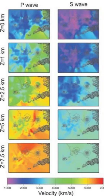
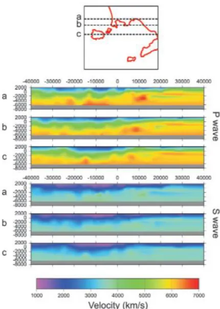
The structure of the caldera has been investigating via several 1-to-3 km deep borehols using local earthquake seismic tomography, gravity and magnetic surveys and some teleseismic and wide-angle seismic observation (Rosi and Sbrana, 1987; Aster and Meyer, 1988; Ferrucci et al.,1992). The boreholes shown that the caldera is characterized by high temperatures at shallow depths (390° measured at 3 km depth) (De Lorenzo et al., 2001). The caldera is filled by a layer of volcanic deposits, a few kilometres thick, which forms and inner basin that is characterized by a low P-velocity (Vp), high Vp-Vs ratio, and high P-wave attenuation and low density.
Vanorio (2005) modelling of rock physical properties interpret a low 𝑉𝑝/𝑉𝑠 anomaly at 4 km depth
as the top of formations enriched in gas under supercritical conditions. This interpretation excludes the presence of melted rocks at 4Km depth that require high 𝑉𝑝/𝑉𝑠ratio. This is also in accord with
the results of Zollo et al. (2003). He analysed the dataset of 82-84 bradyseismic crisis where the earthquake locations are mostly distributed on the top of velocity reversals and within the low 𝑉𝑝/𝑉𝑠
anomaly hypnotizing that seismicity might be induced by overpressured fluids.
In September 2001, a marine active seismic survey (SERAPIS) was performed in the bay of Naples to investigate the shallow structure and detecting the deeper magmatic system using seismic tomography and migration techniques (Zollo et al., 2003; Judenherc and Zollo, 2004). The high resolution 3D tomographic images of the Campi Flegrei caldera revealed the presence of a ring like,
high P-velocity and high density body at 800-2.000 m in depth, with diameter of about 8.000 – 12.000 m and a thickness of 1.000-2.000 m, which has been interpreted as the buried rim of the caldera (Zollo et al., 2003). Tomographic images revealed also the position of dikes, volcanic structures and the off-shore fumaroles detected in the Gulf of Pozzuoli (De Bonatibus et al., 1970; Pescatore et al., 1984; Milia, 1998; Milia and Torrente, 2003). The presence of these structures suggests the existence of a highly fractured area, through which the magma and gases may rise to the surface (Dello Iacono, 2009).
The eastern side of the caldera is bordered by a regional SW-NE normal fault that affects the carbonate basement at 4000 – 5000 m at depth suggesting that the eruptive activity of CFc is fed by regional fractures that are directly linked to a deep magma reservoir.
Magnetotelluric surveys of Zollo et al. (2006) shown a low resistivity zone, 4000m under the town of Pozzuoli, while low VP/Vs anomalies recorded in the same area was interpreted as a constraint to evidence an horizontal interface around this depth. The high attenuation beneath La starza and Pozzuoli-Solfatara at -3000 m is interpreted as due to the presence of a vapour-filled conduit. Similar low-velocity ratio conduits was reported for Redoubt volcano in Alaska (Benz et al., 1996), Mt.Etna, Italy (Villase𝑛̃or et al.,1998) Aso volcano, Japan (Sudo and Kong, 2001) and Mt. Vesuvius (Scarpa et al., 2002) all interpreted as highly fractured zones and/ or active magma conduct system. Low Vp/Vs ratio is also detected in geo-and hydro-thermally active areas, such as the Yellowstone caldera (Chatterjee et al., 1985), the Coso Region (Walk, 1988) and the Geysers geothermal area, California (Julian et al., 1996). In CFc the strong attenuation can be explained by the presence of the vapour phase in the rock matrix, on the basis of the theory of Takei (2002). De Siena (2010) also detect a small melt patches present at 2000 m that may contribute to the magmatic gases flow and interact with the hydrothermal basins and gas reservoirs recognized at shallower depths. Another attenuation anomaly was found around -3200 m that may constitutes the upper part of a
vapour-filled conduit that may be connected with the -7500m sill and /or associated with the melt zone located at -3200 m contributing to the transport of magmatic gases towards the surface (De Siena, 2010) as suggest Nakajima and Hasegawa (2003) for Naruko volcano.
Zollo (2008) modelling magma properties based on measured seismic velocities, indicating the occurrence of a partial melting zone, with a relatively high melt percentage (65-90%). He showed that the horizontal extension of the melt layer beneath Campi Flegrei can be estimated not less than 30 𝑘𝑚2 with an approximate thickness of 1 km. In CFc exists a shallow, extended fracturated rock
layer saturated with supercritical fluids, above a mid-crustal melt zone. This is a similar observation at other unrest calderas, such as Yellowstone and Long Valley (Husent et al., 2004; Chang et al., 2007; Sorey et al., 1998). At 7000 m deep, Zollo (2008) also revealed 2000 m thick low velocity layer interpreted as being associated with a mid-crust, partial melting zone, suggesting a large magmatic sill present in the basement formation.
The attenutation tomography by De Siena (2010) suggest three geothermal basins, located beneath Pozzuoli, between 0 and -3000 m, Mofete and Mt.Nuovo, between -500m and -2500m, and beneath Agnano, between -1000 m and -3000 m. Geothermal drilling also has shown high-temperature gradients in all of these area (150°C 𝑘𝑚−1), and the presence of two distinct aquifers
in the Agnano area at 150-300 m and 1250-1600 m of depth. These aquifer may interact with the conduit, favouring the upward circulation of hot non-magmatic vapor that constitute the main part of the fumarole gases at the surface (Caliro et al., 2007). Todesco et al. (2003), Hansen et al.(2004) and Caliro et al.(2007) suggest and interpreted also a gas reservoir between 0 and -2500 m at north-westward of the solfatara crater, also on the basis of diffuse degassing (Fig 2). Chiarabba et al. (2006) suggest that the model of unrest is the fluctuation of gas over-pressure within the reservoir located at 2-4 km beneath the caldera (identified by low Vp and low Vp/Vs). In their
opinion, if exists a magma chamber responsible of the heat, it’s located beneath 4 km identifiable with direct body wave arrivals of local earthquakes and shots.
1.3.2 Other calderas
Many caldera in the world present the same characteristic of Campi flegrei caldera
Yellowstone
Yellowstone is a volcanic field with 3 younger caldera with less of 2.1 mln years.Yellowstone belong to the more recent manifestation of hotspot that produced big caldera spread on 700Km along the Snake River plain starting from Nevada. Magmatism started about 16.5 Mln years ago and moved progressively to north-east as the principal North-American plate that moves constantly to south-west relatively to an apparently fixed hotspot of mantel. Movement rate of the plate seems to stay constant while volcanism rate decrease may be due to the cooler and more thin nature of the continental crust on which affect the hotspot.
Presence of mantle hotspot at low density create an anomaly of geode, that to Yellowstone is 10 meters above which of geometric ellipsoid. The size of the anomaly is similar to that of oceanic hotspot so how the Hawaii island, Azores and Galapagos. The anomaly is accompanied by topographic anomaly for which Yellowstone is located 600 m above surrounding area. Yellowstone also is located in a tectonically active zone, in a point of intersection really complex of the hotspot with Basin and Range district which diffuse actively and old fault and trust of rock mountains that tent to release part of regional stress.
Fault trend and earthquake epicentres change when are located in the Yellowstone area, passing from a north-south azimuth to north-east. Resulting a tectonic parable that rotate around
Yellowstone and shows clearly the high influence of Yellowstone and the influence of the hotspot on the regional stress field.
More, 640.000 years ago was generated the caldera that then was buried by lava.
Map of epicentres distribution in the caldera shows a linear trend that means that regional fault controls the most part of earthquakes under the caldera. More the post-calderic vents formed with lava flow follow linear trend through central caldera and along west edges, parallel to structural grains of mountains at south the caldera.
As many volcanoes, Yellowstone has hydrothermal system activity as steam and hot water, that stay between earth surface and magmatic chamber.
In 70’s geodetic survey demonstrate that the central part of the caldera is rise of 80 cm from 20’s identifying resurgent dome in central part. Other studies document formation of post glacial crater of hydrothermal explosions, young faults and plentiful seismicity.
Even if the Yellowstone fumaroles have lower temperatures than other volcanoes, millions of thermal zone cover the 70𝐾𝑚2 area. Convective thermal flow estimate is 5-6 GW with a mean of
2 𝑊/𝑚2 into the caldera that is 30 times the mean continental value. More, studying the value of
𝐶𝑂2 reveals an anomaly that is that Yellowstone releasing over 45.000 tonnes per day.
It’s unknown if Yellowstone is in cooling or warming because the heat and gas are consistent either with cooling of a big rhyolitic-static magmatic chamber either with accumulation of hot basalt with mantel source.
A P-waves anomaly is founded at 8 Km depth through seismic tomography based on local earthquake, that may interpreted as a partially melt zone with an inverted banana shape which final part are resurgent domes. From hypocentre maximum depth is understood that ductile rock with 350°C of temperature exists at 5 Km of depth. Out from the caldera these temperatures aren’t
obtained more superficially of 15 Km. Gravity field of Yellowstone is dominated by 60 residual mGal centred on caldera and extended to north-east. Models relative to this data suggest that the caldera is at the basis of volcanic deposits at low density located on a top of a crystallized body of rhyolitic magma. Given the dimension of the caldera and the implicated depth, is reasonable that almost 15.000 𝑘𝑚3 of melt and crystal is linked above the caldera at 8-18 Km depth. If the melt
fraction are 0.1-0.15, exist enough melt to form mass for super-eruption if it’s removed and will accumulate in a manageable volume. Among signals type measured, earthquake swarms are a common way to release seismic energy to Yellowstone as in the other calderic system. At Yellowstone, from 1000 to 3000 / year earthquake are recorded by the monitoring system. 2/3 of them are recorded in the area with trending east-west linear that link Hebgen Lake with north edge of the caldera. The earthquakes seem to be concentrated along a trend of a buried ring-fractures system formed during calderic collapse during the eruption of 2.1 million of years and may be the result of stress transferred in the area from the earthquake of Hebgen Lake of 7.5 magnitude recorded in 1959.
Other earthquakes happen along a linear trend inside the caldera along faults located at south of the caldera in the hydrothermal zone and in geyser reservoirs. 1/3 of these earthquakes are linked to discrete swarms of little earthquake happen on an area concentrated for a limited time. Many of these happened in the first seismogenetic zone, others inside the caldera or south or east. A big swarm happened in the autumn of 1985 with 3000 events recordable until 4.9 magnitude in a period of three months in the area that go to north-east of the caldera until Hebgen lake.
Long Valley Caldera
The Long Valley caldera is a complex volcanic system along the eastern Sierra Nevada, California of 600 𝑘𝑚3 large.
The Caldera was generated from a super eruption of 760000 years ago. The most recent eruptions were on the order of 50.000 years ago (Bayley, 1989) In the last few thousand years has taken place smaller-scale activity along the Mono/Inyo chain of craters, west and northwest of the caldera (Bailey,1989). Geodetic data reveal a deformation since 1980 associated with uplift of resurgent dome and in the last years seems to be correlated with injection beneath the Mono/Inyo craters . Presence of magma body beneath the surface of the caldera has inferred by indirect evidence as velocity anomalies and S-wave shadowing. A deformation model used geodetic data suggest intrusion for the last unrest (1997) with inflating Mogi source from 5 to 12 km depth (Langbein et al., 1998). The seismic activity in the region has generally regarded as tectonic, either an accommodation of strain due to inflation of a resurgent dome or a reflection of the ongoing extensional tectonic process.
Scientist also recorded Lp and VLP volcanic earthquakes that reflect movement of magmatic fluid slug or hydrothermal from 3 to 30 Km of depth (Hill et al 2002 a,b). The seismic activity recently occurred beneath Mammoth Mountain with most notably swarm of six months’ duration in 1989 (Hill et al. 1990)
Deep Lp earthquakes are documented in a certain volcano environment, usually during magma recharge periods at mid and lower crustal levels. These events aren’t recorded in Yellowstone but is unknown if don’t happen or aren’t identify because too small.
Earthquake produce effects that may be recorded in other signals as deformation, gas temperatures and other signals. After a 7.5 magnitude earthquake, are recorded many changes of hydrothermal system. After some days was erupted geyser from 289 sources, 160 never erupted before. Change in the system cause increase in temperature and turbidity. 590 sources become muddy in the first days after the vent, many return clear after some days, others after years. Temperature data for Firehole river sources shown increase of temperature of 3° respect value of temperature before the
earthquake. Change in permeability in the surface caused conversion from cold ground to thermal ground for months, after the earthquake.
80 cm of uplift was measured before 1983 but until mid-1990 was present subsidence inside the caldera. At the end of 1990 deformation data shown that two resurgent domes may operate independently with one that arise and the other one still or in subduction. Today we know that uplift may happen either inside and outside of the caldera and thanks to GPS and INSAR data revealed that between 1997 and 2003, centre-north caldera suffered 20 cm of uplift, while resurgent domes subsided, then deformation shifted to resurgent domes that began to rise with more of 8 cm of movement recorded from gps stations continuously from 2004 until present. The reason for deformation may be magmatic intrusion, hydrothermal fluids migration or brine or gas.
The hydrothermal system exerts an own eruptive activity, including not only steam geyser and hot water, but also explosive hydrothermal eruption that ejected rock fragments. In the last 30 years, many of this events were small and formed small craters, even if geologist identify 10-20 crater of recent hydrothermal explosion with diameters that goes from 100 to 300 meters. The trigger of this events may include earthquake, rise of gas emission or decrease of hydrostatic pressure resulting from deglaciation or drought.
Uplifts located in the north-central caldera recently seem to be linked to temporary hydrothermal phenomena. During the period 1997-2003, uplift in this area produced dilatation more than 6 microstrain. This dilatation may be responsible for some unusual thermal phenomena notated near the Norris geyser basins during 2003, in which normally sleeping gayster steamboat erupted 3 times, opening a rift of 75 meters north Norris, created a new fumarole field and a disorder in the geyser generate new mud pools, fumarole and all the vegetation died by heat. In the autumn of 1985, bigger earthquake swarm coincide with a change from a long terms uplift to subsidence period. Earthquake happen for accumulated stress release in the caldera wall and permit at pressure
in the form of hydrothermal fluid, to be release in higher regions. Waite & smith (2002) interpreted swarms as migration fluids along an almost vertical crack from the caldera, while Husen et al. 2004 founded an area of anomalous seismicity speed that interpreted as evidence of gas accumulation in the same region of the 1985 swarm. These correlations are made also in the Campi Flegrei, where a long term record of fumarole output, show that cycles of uplift/subsidence are followed by change in the ratio 𝐶𝑂2/steam of discharge gas. Phenomenon interpreted as period of increase of release of
magmatic gas (Todesco et al 2004)
In 1980 there was an unrest in the long valley caldera that started with 4 earthquake of 6 magnitude degrees, three of which happened in the same day. Recording quickly the deformation area found evidence for 20 cm of uplift respect the precedent summer. From 2006, caldera had 80cm of intermittent uplift with 1100 earthquake over 3 of magnitude.
Iwo jima
Iwo jima is a volcanic island to 1200 Km from Tokyo that is a resurgent dome of a caldera apparently formed 3000 years ago during a big volcanic eruption. Many shoreline terraces preserve record of island rising of 120 Km in the last 420 years. Also in the last 25 years of volcanic monitoring, part of the island is rise of 3.5 meters. Geodethic unrest is follow by occasional hydrothermal explosion, swarms and hot fluids and gas.
Taupo
The last super-eruptions happened in the volcanic area of Taupo in New Zeland 26000 years ago. Pinatubo
The most recent eruption with VEI 7 happened in 1815 in Tambora, Indonesia. Only one VEI 6 happened in the monitored volcano of Pinatubo in Philippine.
It’s a caldera that it’s think is formed during an on large scale eruption about 25ka years ago and subsequently re-feeding by dacitic domes.
This island suffers 14 cm of uplift during the ’90th volcanic crisis. Historical eruptions are limited
to phreatic explosion how evidenced by numerous craters in the south-east of the caldera. Along the roof of the caldera and the south part of the wall, there are superficial expressions of the hydrothermal system included hydrothermal deposits, fumarole, mud pool and boiled water pool (Caliro et al., 2005).
Actual models of the source structure are
- Magmatic body at unknown depth that inject heat and fluids to the hydrothermal system - Deep boiled aquifer situated more than 900 m under the sea level.
- Superficial reservoir with variable temperature alimented by steam mix separated from deep aquifer and meteoric water.
Gottsmann et al. (2005), shown and demonstrate existence of brief term dynamic in the order of 10 min, through analysis of residual gravity change visible only from the inside caldera, which change are of the order of that recorded in CFC during standard survey. GPS record shown a ground subsidence relative to gravity decrease. Similar brief term deformations are observed also in Yellowstone caldera.
In continuous record are founded spikes episodes near 30, 300, 450 e 520 minutes indicating a relative movement of the ground of 0.15 meters. Gravity records of these events shown a local minimum, the seismic record indicates a clear intensity spikes when there are these changes. Wave shape of some spike to 450, 480 and 490 minutes suggest episodes of tremor that for Caliro et al.2005, may be interpreted as instability in degassing progress at superficial depth. It’s not possible constrain their depth but it’s possible exclude that hydrothermal aquifer that is at 1300-1800 meters’ depth under the caldera roof, may be the source of seismic signal. Caliro et al. (2005) found
evidences of interaction between magmatic/hydrothermal fluids and host rock in depth through LP events. In Nysiros are founded discrete LP events but low frequency energy is present in continuous seismic record. Wave shapes similar to tremor are individuated during degassing with open conduct activity in volcano as Stromboli, Erta Ale, Ambrym interpreted as sovraposition of discrete series of burst that was proposed as interpretation also for nysiros. Are associated with that burst with instability during magmatic degassing but is not possible found source position (Gottsmann, 2007 and reference there in)
Tikku et al 2006 using a multiday gravimetric record interpreted variation in microseismicity record in an active basin of geyser in Yellowstone as induct tremor from fluids flow.
To Gottsman (2007) tremor result to be due to a sudden disorder of the hydrothermal system that may be caused by pressure variation for non statistical degassing of a deep magma reservoir that feed a deep aquifer with boiling temperature around 340°C (Caliro et al., 2005 and reference there in).
Supercritical fluids are source very efficient for volume variation that bring to a rude change of pressure. In that model, a sudden increase of pressure due for example to anomalous degassing in depth became shallow elastic deformation. Associated increase of gravity is caused by Bouger effects of deformation and resulting propagation of density boundaries in a planar reservoir.
The disorder that cause the tremor may be explained from coalescence and bubbles rise.
Dissipated pressurization from release upward of fluids and steam along new formation fractures and faults results in ground subsidence and decrease of residual gravity
Change in electrical properties that is also recorded is due to fluids and steams separation by high deep temperature of aquifer that recharge shallower and with low temperature reservoir.
So many studies concluded that the caldera unrest are due to put in place of magma in depth, which cause geophysical signals quantify in surface for weeks, months and years. But less periods of unrest in caldera are culminated in volcanic eruption so the attention is focused on hydrothermal system because fluids migration produces seismic signals.
1.3.3 Campi Flegrei caldera characteristics and precursors
Actually, the CFc is characterized by gas emissions, seismic activity, ground deformation (crustal uplift) and subsidence. For this reason, relative sea level variations are very intense in the Pozzuoli area, that is in the center of the caldera. The values of sea level variations contrast with the average 50 cm sea - level rise recorded in the north west Mediterranean Sea since Roman time. Local chronicles report repeated episodes of ground uplift preceding the 1538 A.D eruption and, two days before the eruption, a ground uplift of 7m and 200m seaward shift of the coastline was reported (Delli Falconi’s report). Sea level measurement was estimate using the ruins of a Roman market built in the town of Pozzuoli that indicate that a subsidence was interrupted by a 7 meters uplift that took place west of Pozzuoli between 1530 and 1538 AD, culminating with the Monte Nuovo eruption.
The recent volcanic activity is confined in the NyT caldera (Orsi et al.,1996). After a period of subsidence that endures from 1538 A.D. Monte Nuovo eruption, three other major events affected this area dating to 1950-1952, with 73 cm of measured uplift; 1969 – 1972 with 177cm of measured uplift and 1982 – 84 (Del Gaudio et al., 2010). For the last one a maximum net uplift of 179cm was measured at Pozzuoli in the central part of the caldera (Orsi,1999) and it was accompanied by almost 16000 shallow earthquakes.
During the past 12 ka, the CFc has been deformed by subsidence and resurgence events located inside the NYT caldera. Resurgence began between 10.5 and 8 ka (Giudicepietro,1993). It’s possible
that resurgence occurs when new magma, entered the shallow reservoir and rose to the surface along a deep regional fault system. From investigations on the surface separating marine and continental deposits, the results show that the resurgence of the central part of the NYT caldera is not homogeneous (Orsi,1996). Short-term deformations are studied in the recent times from Monte Nuovo eruptions where a slow uplift and seismic activity related to this uplift occur. Two days before the eruption occurred twenty violent earthquakes and was generating a vertical displacement of 7 m (Orsi,1996). After the eruption and until 1969 the area was interested by a subsidence. Between 1969 and 1972 was recorder the first monitored uplift with a displacement of 1.7m and was detected in the area of Pozzuoli (Corrado et al.1977). Also this uplift was accompanied by seismicity with epicentres concentrated in the north of Pozzuoli and in the area between Agnano and Averno. Until 1974 the ground continues to go up of 0.22 m, after that there was no seismicity and displacement. At the beginning of 1982 and until 1984 the Campi Flegrei caldera was interesting by a new and intense brady seismic crisis. The vertical displacement measured was of 1.8 m and almost 16000 was recorded, located in the area of Solfatara, Monte Nuovo and north of Pozzuoli, with depth up to 4-5 Km. After that, the general pattern was of subsidence with minor uplift accompanied by seismicity.
Self-sealing processes inducing transient fluid pressure effects may represent significant mechanisms in inflating calderas (Vanorio, 2005). Hydrothermal system are good environment for permeability destruction process due to mineral precipitation, crack healing and sealing competes together with permeability creation due to fracturing process. In CFc the Presence Of Self-sealing process (Chelini, 1984) might account for fluid pressure generation (Vanorio, 2005).
This dynamic may be done to pore pressure variation inside the hydrothermal reservoir of Campi Flegrei is due to gas rising from magmatic deeper source (Chiodini et al.,2010). Analyse of Vp/Vs ratio suggest anomaly values at 3Km depth that suggest the presence of a gas rich zone (Chiarabba
e Moretti, 2006). Uplift seems to be related to hydrothermal fluids migration through NW-SE faults and fracture in Solfatara-Agnano-Astroni area (Chiodini et al, 2010), instead subsidence seems to be due to pore pressure decrease and compaction.
Possible evidences of a magma reservoir at about 4 km of depth are in the identification of a P-SV converted phase in a seismic profile (Ferrucci et al., 1992), in the location of maximum depth of earthquakes and by petrological and geochemical data. The first model for a source for ground deformation was a pressure increase model at the top of a shallow magma chamber embedded in an elastic medium (Berrino et al., 1984; Bonasia et al., 1984; Bianchi et al., 1984, 1987; Dvorak and Berrino, 1991; De Natale and Pingue, 1993). Avallone et al., 1999 used DInSAR images collected between 1993-1996 for estimate a Mogi-type pressure source location located at 800 m offshore SW of the town of Pozzuoli at 2700 m deep. Bonafede et al.(1986) considered the pressure source in a viscoelastic medium. Como and Lembo (1992) developed a numerical model to simulate the effects of fracturation and conductive thermal propagation on the ground deformation. Gaeta et al. (1998) proposed a model based to the interaction between a thermal source and the circulation of groundwater in a permeable system, showing that hydrothermal system have effect of amplifying the ground deformation.
So ground deformation can be due to an inflation of magma chamber in depth or to the injection of gravitational fluids and it represents an important precursor. However, an important rule is played by heating and pressurization of pore fluids, which may result from an increased magmatic degassing (Morhange et.al, 2006). The subsidence that started in 1985 continues today and it is interrupted by short uplift episodes recorded at 1989, 1994, 2000, 2004, 2010 accompained by microseismicity. Recent seismicity consists in volcano-tectonic and long Period events (D’Auria et al.2011).
Ground deformation is one of most important precursor phenomena and one of principal instrument for short-term forecast of eruptive activity. So it’s widely studied with various techniques and equipment.
Actually, Solfatara crater is the area with strongest geothermal emission and consists in about 5000 𝑡 𝑑−1 of 𝐶𝑂2− 𝐻2𝑂 mixture with power of 100 M that is 10 times higher than the heat flux in the whole caldera surface (Chiodini et al. 2010).
Chiodini et al. (2003) proposed that an enhanced flooding of fluids caused by degassing from a deeper magmatic reservoir may be the source of gas. Vanorio(2005) suggest instead that also the CO2 production promoted by decarbonation reactions (D’Amico et al., 1987; Rosi and Sbrana, 1987) which occur in carbonate rocks under high temperatures (T≥300°C) may be as well. This hypothesis is supported by the evidence of a carbonatic basement reported by Zollo et al. (2003) and the finding of tuffits with carbonatic matrix in the thermo metamorphic basement at 3000 m (Chelini, 1984).
Only the Solfatara crater releases about 1500 t/day of volcanic-hydrothermal CO2 as a result of diffuse degassing through ground. During this process, about 3350 t/day of steam condenses, generating hydrothermal fluid circulation (Chiodini et al., 2001); The heat (7.5 x 10^12 J/day) released by condensation represents the largest part of the total heat dissipated by hydrothermal degassing at Solfatara. Hypothesis suggest that hydrothermal fluids at Solfatara induce enhance rock deformation (Oliveri del Castillo and Montagna, 1984; Bonafede, 1991; De Natale et al., 1991; Gaeta et al., 1998) increasing pore pressure, so modifying effective stress, and rock temperature.
2.1 Seismic data
Volcanic areas are complex structures characterized by solidified intrusion, partially molten regions, geothermally altered rocks and indicates deposits of different shapes, thickness and compositions.
The seismicity associate to volcanic areas is often characterized by swarm-type earthquake with features different respect those occurring in other tectonically active zone (Klein et al., 1977). Models for the occurring of these seismic events that occur grouped in space and time, explain this behaviour with highly heterogeneous distribution of material fracture strength and/or stress concentration (Mogi, 1963; Sholz, 1968).
Usually the seismicity associated with active volcanism is characterized by Long- Period (LP) signals accompanied by VT events in the same period. There are examples of this correlation not only in Campi Flegrei caldera but also in Long Valley (Hough et al., 2000), Nisyros (Caliro et al., 2005). In all the cases it was interpreted as the effects of fluid migration.
The presence of LP signals in volcanic/hydrothermal areas is indicative of a source mechanism associated with fluid-rock interaction and could represent an indicator of renewing activity (Chouet, 1996a,2003).
While VT events are due to brittle failure in response to stress changes associate with magmatic activity, LP events are attributed to resonance of fluid-filled crack or conduits induced by pressure transients in the fluid (Aki et al., 1977; Chouet, 1985, 1988,1992). LP events are discrete signals having an amplitude envelope similar to normal earthquakes but spectral characteristic similar to tremor. These events often show high frequencies superimposed on their waveforms near the onset of the signal (Fehler and Chouet 1982; Bame and Fehler 1986). Tipically the duration of the long
period evens is of the order of 150ms and the dominant frequency is in the range 100-300 Hz (Bame and Fehler 1986).
In 1979, Lawrence and Qamar noted for the first time similarity between long- period events occurring on volcanoes and low-frequency glacial icequakes postulating that the two types of events may be linked to fluid transients in fluid-filled conduits under volcanoes and glaciers. Bume and Fehler (1986) also found evidence that the first seismic events to occur during hydraulic fracturing of virgin rock are long-period events with duration and amplitude very small in comparison with volcanic long period. Long period events have similarity also with tremor, noted by various investigators (Dibble, 1974; Capaldi et al., 1978; Latter, 1979: Fehler, 1983; Malone, 1983; Qamar et al., 1983; Koyanagi et al., 1987) bring to the hypothesis that harmonic tremor is a swarm of long-period events (Fehler, 1983; Koyanagi et al., 1987). Chouet (1985) showed the relationship between the long-period events and tremor suggesting that the two signals represent different excitations of a common fluid-filled cavity where the long period represent the impulse response of the tremor-generating system and the tremor is the response of the cavity to a more sustained driving mechanism.
In nature, exists events that have similar waveform at all observation stations. These events are called microseismic doublets or multiplets. Member of this category of events, generally occur close together so as to define a cluster and have similar focal mechanisms (Poupinet et al., 1984; Moriya et al., 1994; Philips et al., 1997). Because of the waveform similarity, it’s possible performed a relative-location analysis using a cross-correlation technique.
In seismology are interesting into research of correlation between effusive activity, volcano structures, chemic-physic magma properties and seismic manifestation in volcanic area. In the last time, micro-earthquakes agitation is considered separately with earthquake, because they are distinct events and in certain limit also independent each other.
Microseismic events represent shear or mixed-mode failure of rocks along pre-existing planes of weakness that is accompanied by significant seismic energy release at relatively high frequencies (Tezuka 2000).
These type of events are usually recorded during the bradyseismic crisis of Campi Flegrei Caldera. Parameters that better characterize the micro-earthquakes are period and amplitude and in second time also propagation velocity. In the opinion of Minakami in the study of microseismic period, cannot rescind from magma chemistry; In particular, greater period correspond mostly to basic magmatism and so to relatively fluids lavas. From other authors period variation of microsism are related with depth of lavas source position and with the phase of volcano activity. It was observed that during quiescence phases, when magma is at greater depth in the volcano conduct, the period is bigger than which corresponding to effusive eruptive phases.
Regards the amplitudes, micro-earthquakes with volcanic origin are not so distant with which due to other causes like wind, wave motion and human activities, but the different with the others is that the micro-earthquake shown the characteristic of rapid attenuation with source distance. K is the attenuation coefficient that is present in this relation:
𝐴𝑛(𝑇, ∆) = 𝐴0(𝑇) ∗ 𝑒(−𝐾(𝑇)∆)∗ ∆𝑛−𝑎
With 𝐴𝑛 the amplitude at the n-th station. 𝐴0 amplitude at the source point. ∆𝑛 distance between
source and station n, 𝑎 is the numeric constant.
Minakami calculated k for Sakura-jima e mihara volcanoes: 0.8 − 0.9 ∗ 10−5/𝑐𝑚
0.2 − 0.3 ∗ 10−5/𝑐𝑚
In relation with hypocentre depth, Minakami distinguish four types of seismic manifestation a) Volcanic pulsation constitutes from train of harmonic oscillations which origins are in the
area of terminal crater.
b) Earthquake B-type that have origin in the up part of volcano. Seems to be associated to eruptive activity.
c) Earthquake associated to explosive eruption.
d) Earthquake A-type with hypocentre at some kilometres depth and relatively less frequent. (Bottari-ruscetti, 1967).
Attenuation of elastic waves depends on may factors through which temperature and presence of fractures that may be permeated by fluids (Eberhart-Phillips et al., 2005)
It’s possible quantify alteration using the quality factor Q, that is the ratio between the energy lost by a wave cycle and the energy of the cycle itself (De Siena, 2010) or through the attenuation coefficient 𝛼 = 𝜋𝑓𝑟/𝑣𝑄 that is a function of distance r and of frequency f. The coefficient may vary for the same amount of rock on the basis of chemical composition, temperature and degree of fracturing. In particular, for volcanic areas is essential to know either the Qp P-wave quality factor and the Qs S-wave quality factor for a complete characterization of the rocks inside the volcano cause the different response of the rocks to longitudinal and shear waves.
Another important parameter to take in account is the scattering. When a wavefield interacts with small scale heterogeneities in the elastic parameters happened that the High-frequency energy of direct P and S- waves is transfer in the coda of the seismograms, that is the scattering process (Sato and Fehler, 1998)
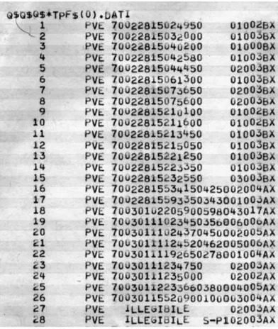
2.2 Campi Flegrei caldera seismicity
Campi Flegrei caldera is a site of intense seismicity related to magmatic activity. As report from historical record from Selli Falconi(1538), Simone Porzio (1551) and Mercalli(1891), the caldera was interested by an intense seismic activity 2 years preceding the Monte Nuovo eruption increasing in the last 2 days. Since 1969, the level of activity is variable in dependence from