Across Space and Time
Papers from the 41st Conference
on Computer Applications and
Quantitative Methods in Archaeology
Perth, 25-28 March 2013
Edited by Arianna Traviglia
Arianna T ra viglia ( ed.)
A
cr
os
s Sp
ac
e and T
ime
AUP.nl
9 789089 647153 ISBN 978 90 8964 715 3Papers from
the 41
st
Conference on
Computer Applications and Quantitative
Methods in Archaeology
Perth, 25-28 March 2013
Edited by
Cover design: Ian Kirkpatrick
Cover image: Wanmanna archaeological site and computer renderings of reconstructed 3D surfaces and rock art. Original images copyright: CRAR+M (Centre for Rock Art Research + Management: The University of Western Australia). Images courtesy of Paul Bourke, iVEC@ UWA (The University of Western Australia). Images reproduced with permission from Niyarpirli traditional custodians, Newman.
Lay-out: IzaRomanowska
Amsterdam University Press English-language titles are distributed in the US and Canada by the University of Chicago Press.
ISBN 9789089647153 (hardback) e-ISBN 9789048524433 (pdf) NUR 682
© Computer Applications and Quantitative Methods in Archaeology (CAA) / Amsterdam University Press, Amsterdam 2015
All rights reserved. Without limiting the rights under copyright reserved above, no part of this book may be reproduced, stored in or introduced into a retrieval system, or transmitted, in any form or by any means (electronic, mechanical, photocopying, recording or otherwise) without the written permission of both the copyright owner and the author of the book.
Every effort has been made to obtain permission to use all copyrighted illustrations reproduced in this book. Nonetheless, whosoever believes to have rights to this material is advised to contact the publisher.
This book is published in the CAA series Computer Applications and Quantitative
Methods in Archaeology.
15 Across Space and Time
Arianna Traviglia
23
DATA ACQUISITION
25 Remote Sensing in Maritime Archaeology, from the Slide Rule to the Supercomputer*
Jeremy N. Green
36 Remote Sensing (Short and Long Range)
36 The Story Beneath the Canopy: an Airborne Lidar Survey Over Angkor, Phnom Kulen
and Koh Ker, Northwestern Cambodia
Damian Evans, Kasper Hanus, Roland Fletcher
45 GeOBIA Approaches to Remote Sensing of Fossil Landscapes: Two Case Studies from
Northern Italy
Armando De Guio, Luigi Magnini and Cinzia Bettineschi
54 Palmyra Revisited from Space – High-Resolution Satellite Prospection of a UNESCO
World Heritage Site
Roland Linck, Jörg W. E. Fassbinder, Stefan Buckreuss
64 Classification of Geophysical Data of Angkor, Cambodia and its Potential as an Online
Source
Till F. Sonnemann
70 Field and Laboratory Data Recording
70 The Accuracy of the Field Survey Results and its Implications in the Correct
Understanding of Past and Present Practices
Luis Antonio Sevillano Perea and Victorino Mayoral Herrera
80 Arbitrary Offline Data Capture on All of Your Androids: The FAIMS Mobile Platform
Adela Sobotkova, Brian Ballsun-Stanton, Shawn Ross, Penny Crook
89 Creating a Paperless Recording System for Pilbara Rock Art
Stafford Smith, Jo McDonald, Jane Balme, Glen MacLaren, Alistair Paterson
97 Beyond Tablet Computers as a Tool for Data Collection: Three Seasons of Processing
and Curating Digital Data in a Paperless World
John Wallrodt, Kevin Dicus, Leigh Lieberman, Gregory Tucker
104 Applying Low Budget Equipment and Open Source Software for High Resolution Documentation of Archaeological Stratigraphy and Features
Undine Lieberwirth, Bernhard Fritsch, Markus Metz, Markus Neteler, Kerstin Kühnle
120 Old Problems and New Challenges in Archaeological Sites Data Management. The REVEAL Experience at Ammaia (Portugal)
129 The Parnassus Project: Archaeology and Engineering Collaboration for 3D Data Collection and Analysis
Dina D’Ayala, Penny Copeland, Yasemin Didem Aktas, Graeme Earl, Aykut Erkal, James Miles, Elizabeth Richley, Victoria Stephenson, Kris Strutt
144 Photogrammetry and RTI Survey of Hoa Hakananai’a Easter Island Statue
James Miles, Mike Pitts, Hembo Pagi, Graeme Earl
156 Some Methodological Considerations and Suggestions for Good Practice in
Diagnosticsand Visualizations of Complex Archaeological Sites: the Experience of the Radio-Past Project
Frank Vermeulen, Cristina Corsi
167 DATA ANALYSIS AND MANAGEMENT
169 Reflections Upon 30+ Years of Computing and Field Archaeology in the
Valey of Pickering, North Yorkshire UK. *
Dominic Powlesland
192 Computational Modelling and GIS
192 Competition and Culture Change in Prehistoric Socio-Environmental Systems
Carolin Vegvari, Robert A. Foley
203 Agent-based Modelling and Archaeological Hypothesis Testing: the Case Study of the
European Lower Palaeolithic
Iza Romanowska
215 Sailing the Simulated Seas: a New Simulation for Evaluating Prehistoric Seafaring ⊗
Benjamin Davies, Simon H. Bickler
224 Agricultural Territories and GIS Modelling: the Long-Term Case Study of Menorca
Monica De Cet, Rainer Duttmann, Vicente Lull, Rafael Micó, Johannes Müller, Cristina Rihuete Herrada, Roberto Risch, Philip Verhagen
239 Systemic Approach and Spatial Organization: from the City to Networks of Cities
Xavier Rodier, Lahouari Kaddouri, Pierre Garmy
249 Detection of Spatio-Morphological Structures 0n the Basis of Archaeological Data with Mathematical Morphology and Variogaphy. Application to Syrian Archaeological
Sites
Johanna Fusco
261 Least Cost Path Analysis for Predicting Glacial Archaeological Site Potential in Central
Europe
Stephanie R. Rogers, Claude Collet, Ralph Lugon
276 Spatial Statistic Analysis of Dating Using Pottery: an Aid to the Characterization of
Cultural Areas in West Central France
Lise Bellanger, Philippe Husi, Yassine Laghzali
283 Scale Dependent Patterns in South-Eastern Norway
298 Kolmogorov-Smirnov Statistics in the Context of Centuriation
John William Michael Peterson
303 Data Management and Analysis
303 Integration of CIDOC CRM with OGC Standards to Model Spatial Information
Gerald Hiebel, Martin Doerr, Øyvind Eide
311 Reality Bites: Reviewing a Decade of Online Collaboration
Susan Hamilton, Peter McKeague
319 An Empirical Approach to the Analysis of Archaeological Discourse
Patricia Martín-Rodilla
326 Expressing Temporal and Subjective Information about Archaeological Entities
Cesar Gonzalez-Perez, Patricia Martín-Rodilla, Rebeca Blanco-Rotea
336 From dBase III+ to the Semantic Web: Twenty-Five Years of the Coin Hoards of the
Roman Republic Database
Ethan Gruber, Kris Lockyear
347 Higeomes: Distributed Geodatabases in an Archaeological Joint Research Project
Frank Boochs, Kai-Christian Bruhn, Christophe Cruz, Ashish Karmacharya, Tobias Kohr
358 The Archaeological Resource Cataloging System (ARCS): A Better Way of Working with Digital Archives
Jon M. Frey, Timothy E. Gregory, Lita Tzortzopoulou-Gregory
365 DATA DISSEMINATION
367 Reimagining Archaeological Publication for the 21st Century *
Eric C. Kansa
379 3D Modelling and Visualisation
379 Playing Angkor: Exploring the Historical and Archaeological Themes of the Khmer
Empire through Game Engine Technologies
Tom Chandler
386 The Virtual Archaeology Project - Towards an Interactive Multi-scalar 3D Visualisation
in Computer Game Engines
Arian Goren, Kay Kohlmeyer, Thomas Bremer, Arie Kai-Browne, Wiebke Bebermeier, Dennis Öztürk, Stefan Öztürk, Tobias Müller
401 A Roman Street at the Time of Constantine: Interactive Visit with Access to Ancient
Source Materials
408 Fortress City Saarlouis: Development of an Interactive 3D City Model Using Web Technologies
Kristian Sons, Georg Demme, Wolfgang Herget, Philipp Slusallek
415 An Interactive Virtual Roaming System for Beijing Hutong
Guoguang Du, Zhongke Wu, Mingquan Zhou, Kang Wang, Chongbin Xu, Ziyang Li, Pengfei Xu, Dongcan Jiang and Xingce Wang
423 A Documentation System for Digital Reconstructions with References to the Mausoleum of the Tang-Dynasty at Zhaoling, in Shaanxi Province, China
Mieke Pfarr-Harfst
430 3D Modelling Technologies in Humanities. A Literature-Based Survey about Reconstruction and Visualisation of Historic Objects
Sander Münster, Thomas Köhler, Stephan Hoppe
442 A 3D Assessment Tool for Precise Recording of Ceramic Fragments Using Image Processing and Computational Geometry Tools
Fernando Zvietcovich, Benjamin Castaneda, Luis Jaime Castillo, Julio Saldana
453 Eigen Paicas: A 3D Reconstruction of Entire Vessels Using Information of a Single Fragment and a Database
Fernando Zvietcovich, Benjamin Castaneda, Luis Jaime Castillo, Julio Saldana
463 Towards the Automatic Classification of Pottery Sherds: Two Complementary
Approaches
Chiara Piccoli, Prashant Aparajeya, Georgios Th. Papadopoulos, John Bintliff, Frederic Fol Leymarie, Philip Bes, Mark van der Enden, Jeroen Poblome, Petros Daras
475 Shape and Technological Organisation of Lithic Solutrean Points from Iberia: a Computational Approach for Exploring the Diversity of Shapes
Isabell Schmidt, Vincent Mom
482 Cultural Heritage Management and Interpretation
482 Is the use of GIS in Cultural Heritage Outdated?
Claire Reeler
488 The End Game: As Scotland’s Historic Land-Use Assessment Project Reaches Completion What Have We Learned?
Kirsty Millican and Mike Middleton
494 A 21st Century Record: Maintaining a Modern Monuments Record
Susan Hamilton
501 Preserving Lost Industrial Heritage: Newcastle Australia
Tessa Morrison, Helen Giggins, Nicholas Foulcher
508 Uncovering the Missing Routes: an Algorithmic Study on the Illicit Antiquities Trade
Network
Christos Tsirogiannis, Constantinos Tsirogiannis *: Keynote Address
The present volume includes 50 selected peer-reviewed papers presented at the 41st Computer Applications and Quantitative Methods in Archaeology Across Space and Time (CAA2013) conference held in Perth (Western Australia) in March 2013 at the University Club of Western Australia and hosted by the recently established CAA Australia National Chapter. It also hosts a paper presented at the 40th Computer Applications and Quantitative Methods in Archaeology (CAA2012) conference held in Southampton.
An extended overview of the conference and the proceedings preparation is supplied in the opening paper of this volume and authored by the Conference Chair and Proceedings Editor. This preface will serve instead to acknowledge and thank all the people involved in different roles in the conference organisation and the editorial work behind this volume. The Chair acknowledges the impossibility of mentioning all that have given a contribution, nonetheless she would like to express her sincere gratitude to everyone that participated in making CAA 2013 a thriving event. In the following paragraphs those whose contributions were most essential and most welcomed are recognised and thanked.
Conference organisation
Listing in chronological order, first to be thanked are the members of the CAA Executive Steering Committee and the extended Steering Committee for their precious advises, suggestions and guidance throughout the conference and post-conference process. Among these, special mentions go to Guus Lange for his continuous encouragement and for undertaking a number of reviews larger than anybody else; to the CAA Chair Gary Lock for guidance and direction as well as promptly assisting with last-minute reviews; and to Philip Verhagen for assistance in all the phases of abstract and paper reviewing and editorial process. Likewise, organisers and supporters of previous CAA conferences (such as Graeme Earl, Javier Melero, Jeffrey Clark, Lisa Fischer, Leif Isaksen) should be acknowledged for the helpful insights and suggestions they provided before the event and for sharing their conference organisation experience. John Pouncett and Axel Posluschny should also be recognised for their precious contribution in managing the student bursary program and dealing with financial aspects of it. A special thank goes to Hembo Pagi for the invaluable computer programming service and consultancy that he swiftly provided for the CAA conference management software system (OCS) as well as his positive attitude at hard times.
Among members of the CAA2013 organising committee, a huge debt of gratitude goes to Stephen White for his continuous support, assistance and work in many aspects of the conference organisation that he (almost willingly) undertook since the day in which the CAA 2013 conference was assigned to Australia. In particular, he provided much needed help in dealing with the (many) website layout issues, the final program print layout and hundreds of other tasks, too many to mention or even remember. Enormous appreciation has to be given to Gail Higginbottom, treasurer of the CAA Australia National Chapter, for her invaluable help with assembling the program and creating the layout of the conference schedule as well as a number of other tasks (of which the pinnacle was the organisation of a wine tasting stall at the Venue location) both before and during the conference. Thanks also to Ian Johnson, Chair of the CAA Australia National Chapter, for the first draft of the program booklet and schedule. Huge gratitude goes to Jane Fyfe (University of Western Australia) for the precious ‘local’ logistic support: her understanding of the working of the UWA facilities and infrastructure was fundamental to have quick response to all the problems that had to be faced and access to all the needed services. Jennifer Rodriguez (Western Australian Museum) must be acknowledged for her valuable assistance during the conference and for running the Student-to-student accommodation initiative with the help of Wendy Van Duivenvoorde (Flinders University). The important role of Felicity Morel-Ednie Brown (Western Australia Government) should be recognised for the bid acquisition and fund-raising, this last a task which was crucial to the operation
of the conference. Together with the organising committee members, Martin King (University of Sydney) should be mentioned for all his input before the conference and dealing with accounting, financial and administrative aspects during the months preceding it.
CAA 2013 was also the occasion to forge or reinforce links with colleagues from University of Western Australia. Above all gratitude goes to Thomas Whitley, a long-standing member of CAA North America providentially moved to Australia just shortly before the conference, for all his support in situ, and Toby Burrows for precious assistance with many administration tasks; together with them, the other colleagues of the discipline of Archaeology Jo McDonald, Alistair Paterson and Joe Dortch. To this last, CAA2013 is indebted for taking time from his busy schedule to lead pre and post-conference tours that were highly appreciated. We extend the CAA Australia gratitude to the Vice-Chancellor of the University of Western Australia Professor Paul Johnson and to the Dean of the Faculty of Arts Professor Krishna Sen for the speeches at the Opening ceremony and the Welcome reception.
Volunteers always play a very important role during a conference event. Particular mention must be made of Megan Berry (University of Western Australia) who coordinated the superb cohort of volunteers that ensured the smooth running of the conference at the venue and Sam Harper (University of Western Australia) that enthusiastically helped her in this taxing mission. Thanks also to all the student volunteers that actively gave their time to support the conference, before, during and after, and who are too many to list here. Although unnamed, they were crucial to the operation of the conference. In particular, thanks to Rebecca Foote (University of Western Australia) for her passionate help, for her support in creating maps and signage to ease the CAA delegates moving across the UWA campus and even for swift medical response at a time of need; to Nick Wiggins for taking on many IT and web-based tasks and taking over the management of the social media communication before and during the conference: his assistance was extremely beneficial for the whole conference process; to Elizabeth Smith (Macquarie University) that managed the student volunteers based in Sydney and provided content for the web-site and assistance with delegate accommodations; to Mary Jane Cuyler for her support in acquiring patronage and endorsement. Charlie Dortch, retired curator of archaeology from the WA Museum, must be acknowledged for generously offering to guide the post-conference tour to Rottnest Island.
The Conference keynotes (in order of appearance) Eric Kansa (Open Context and UC Berkeley), Jeremy Green (Western Australian Museum) and Dominic Powlesland (Landscape Research Centre and University of Cambridge, UK) should be mentioned for delivering three excellent keynote addresses that have entertained the CAA audience, made it reflect on important issues facing the future of our discipline and disclosed new horizons of computer applications in archaeology. Many session organisers helped to select appropriate presentations and papers and ran their sessions with dedication, for which we are grateful.
The Conference Chair wishes also to express her sincere gratitude to Len Collard (University of Western Australia) for performing, as part of the opening ceremony, an emotional ‘Welcome to country’, the way local Indigenous land custodians welcome delegates to their country. Based on the Aboriginal dreaming, ‘Welcome to Country’ recognises the ancestral spirits who created the boundaries and lands, and allow safe passage to visitors. The chair would like also to mention Thomas Hillard and Lea Beness for their warm encouragement throughout the difficult and very chaotic period that preceded – and followed – the CAA 2013 conference, and especially Thomas who, in an extremely busy academic teaching period, travelled a total of 6000+ km in less than 3 days only to show his support to this event by attending it for at least one day.
Last but not least, the Chair and the CAA Australia National chapter wish to thank all those who participated, especially the colleagues that have travelled a long distance to be in Perth arriving from Europe, USA, or East Asia, providing exciting contributions that ensured the success of the conference.
2013 to take place. Particular mention must be made of our main contributors, the University of Western Australia and the Perth Convention Bureau together with Tourism Western Australia.
The University of Western Australia provided generous funding for setting up the conference. The University, and in particular the discipline of Archaeology, should be acknowledged also for welcoming the CAA2013 Conference in the UWA Campus and offering their infrastructures, facilities and personnel for a smooth running of the event. The Perth Convention Bureau together with Tourism Western Australia provided financial support for marketing the event, ensuring a wide international participation.
Other organisations and businesses have also contributed to the conference either as sponsors, partners or supporters and to them goes the gratitude of CAA Australia. Archae-aus, our Bronze Sponsor, contributed liberally to the general support fund for the conference. The University of Sydney provided accounting and administrative support as well as IT support with the online payment system. The CAA Australia is also grateful to Macquarie University Ancient Cultures Research Centre, whose sponsorship supported the costs of the venue; to Federated Archaeological Information Management Systems (FAIMS) project for helping to sponsor the opening reception at the University Club; to the Australasian Association for Digital Humanities, which generously funded the Best Poster awards; to Society for the Study of Early Christianity (SSEC) established at Macquarie University and MAHA (Macquarie Ancient History Association) for their kind financial contributions; to Eureka Archaeological Research and Consulting for their sponsorship and the time of their staff members; and to Squire Sanders, which provided legal service as part of an in-kind sponsorship. Conference Partners ArcLand and EARSeL should be mentioned for putting together and chairing sessions related to their areas of expertise. The UWA Maritime Museum (Western Australia Museum) has made an important contribution to CAA2013 and its delegates by extending free entry to conference attendees, for which we are sincerely grateful. The patronage of the Government of Western Australia, City of Perth, Icomos Australia, and CHASS should also be acknowledged.
Publication process
The preparation of a proceeding volume is a huge and time-consuming task and it requires the support of many. First and foremost, Iza Romanowska is deeply appreciated for her undertaking the production of the volume layout and typesetting. Her experience with the editing of CAA proceedings was providential to the efficiency of the overall publication process and her assistance much appreciated; moreover, her infinite patience in dealing with the Editor‘s (sometimes excessive) attention to detail should be certainly recognised. The CAA Editorial Board should also be mentioned for continuous assistance and guidance.
All the anonymous members of the CAA Review Panel, who by painstakingly undertaking the assigned reviews supported the selection of presentations – first – and papers to be published – later – should not be forgotten: the production of a quality peer-reviewed volume relies essentially on them.
Thanks should also be addressed to Paul Bourke (University of Western Australia) and the CRAR+M at the University of Western Australia for the wonderful images that have been used for the creation of the volume cover, representing the Wanmanna archaeological site and computer renderings of reconstructed 3D surfaces and rock art, and of course thanks should be directed to Ian Kirkpatrick for the brilliant design work he produced assembling them together.
Acknowledgement of Country
Finally, on behalf of the CAA2013 conference organisers and CAA Australia the Chair would like to tribute an acknowledgement to the Whadjuck Nyungar who are the Traditional Owners of the Perth metropolitan area and surrounding districts. We would like to acknowledge these traditional owners of the land on which we have held the CAA2013 conference and pay our respects to the Nyungar Elders past, present, and future for they are custodians of the history, the cultural practice, traditions, lands, seas, fresh water and swamps of their people. We thank them for allowing us to meet on their land.
Arianna Traviglia
Bronze Sponsor
Other sponsors and contributors
Exhibitors
Partners
Supporters
Australasian Association for Digital Humanities
The 41st Computer Applications and Quantitative Methods in Archaeology Across Space and Time (CAA2013) conference was held in the city of Perth (Western Australia) from 25th to 28th March 2013. The theme of the conference was ‘Across Space and Time’ which alluded to both the paths that archaeological research moves across and to the space and time that delegates would have to travel to reach the 2013 CAA destination. The conference was hosted by CAA Australia National Chapter, which was purposely created in the months just after the successful bid presented in 2010. Two academic institutions, The University of Western Australia and The University of Sydney, supported the conference in different ways, using their physical and organisational infrastructures. The specific entities involved in the event organisation were the Discipline of Archaeology, School of Social Sciences at the University of Western Australia, and Arts eResearch and the Faculty of Arts (providing accounting support) at the University of Sydney.
The primary venue of CAA 2013 was the University Club of Western Australia, a modern building located in the campus of The University of Western Australia, on the banks of the Swan River facing Matilda Bay and the Perth city skyline. The University Club proved to be an excellent and much appreciated choice for its beautiful location and surroundings, the first-rate conference facilities and the superb management that ensured the smooth running of the conference. Several locations
across the University of Western Australia, where
conference workshops took place on the first and second day, served as secondary venues.
The CAA 2013 Perth conference organisers strove to produce a conference experience that, beside serving the traditional functions of CAA conferences of providing a venue for showcasing, disseminating and discussing advancements in computational and digital methods applied to archaeology, could also promote the wider adoption
of such methods and start collaborative networks within the Australasian region, while extending the membership of CAA in the region.
1. Before the Conference
The candidature to host conference was presented in Granada, Spain, in 2010 during the Fusion of Cultures CAA 2010 conference by the writer and Felicity Morel-Ednie Brown. As indicated in the brief speech preceding the vote at the 2010 CAA AGM, our goal in hosting the conference in Australia was to make CAA fully global and to expand the CAA membership beyond the ‘last frontier’. The following year, 2011, CAA was going to be held in Asia for the first time (Revive the Past CAA 2011, Beijing, China), acting to engage Asian scholars, bring fresh perspectives and build new relationships. Continuing this globalisation pathway, we proposed to hold the CAA conference for 2013 in Australia (the first time that CAA would be conducted in the Southern hemisphere, a milestone in the CAA history), allowing colleagues from Oceania to attend it. The project soon found interest and support by a number of Australian academic institutions, research centres and government bodies that provided assistance for the conference to succeed.
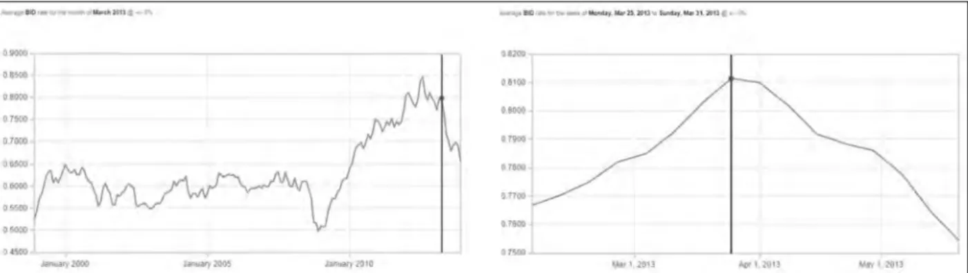
The time leading up to the conference was full of strife. The financial crisis that had hit the global markets in 2008 (and, with them, the economies of many countries worldwide) had not receded during the years and months preceding the CAA 2013 Perth event, and it had indeed worsened the financial situations of European and American countries (and academic institutions). At about the same time, Australia, which had been only marginally shattered by the economic downturn, was starting to enjoy a very strong dollar over most national currencies. That gap kept steadily growing during the year preceding the conference (Fig. 1, left). Perth itself, a thriving city back then at the centre of the Australian mining boom, already boasted what would be
Arianna Traviglia
Across Space and Time. Papers from the 41st Conference on
Computer Applications and Quantitative Methods in Archaeology. Perth, 25-28 March 2013
considered – from a European perspective – high costs for accommodations and meals.
Months before the conference it was clear that these two factors combined together could have represented an explosive situation for typical CAA delegates, making it financially very difficult for many to join the event, especially considering the great distances that one has to cover to reach Perth (even for those simply coming from a different shore of Australia) and the costs related to that. It is to be faced, indeed: the Australian continent is far from pretty much everywhere. The Conference organisers watched with growing preoccupation the increasingly rising exchange rates in the months preceding the conference. Sardonically enough, the week of the conference the exchange rate reached the fourth highest peak in almost 15 years; after that the exchange rate started its slow but unstoppable descent (Fig 1, right).
With these difficulties very clear in mind and faced with the prospect of a very low attendance (and all the financial issues it would create), the organisation team had to devote a considerable amount of energy to fund raising in order to offset the high costs so that they would not have to pass on the real cost of the conference in the way of high registration fees. At the end, thanks to a number of generous contributors, we were able to maintain the fees at the average level of previous conference fees, while offering full board meals and lavish refreshments in the registration package.
In an attempt to support students, low incomers and ECRs with facing the costs of the travel, other programs were initiated, such
as the student-to-student initiative, created to encourage Perth-based student delegates to host students from around Australia or overseas while the visiting student was attending CAA Perth 2013. While providing an opportunity for a cheap accommodation, the purpose of this initiative was to promote national and international links between students and provide a great opportunity to form friendships and professional contacts that may last throughout their careers. In addition, CAA provided, as every year, a set of bursary awards to financially support students, low incomers and ECRs to attend the conference: of the ones eligible to receive financial support, 31 students accepted.
In June 2012, the CAA 2013 organisers issued an open call for sessions proposals. 39 session proposals were received and 35+ accepted (although not all, in the end, were convened) after merging some proposals that focused on similar subjects. Next to the usual session formats, such as roundtables, workshops, short and long sessions, we trialled (in the best tradition of freedom that CAA bestows over local organisers) the Focus session format, consisting of thematically-related five minutes key-point presentations timed by a discussant pulling the theme together, followed by a room-based breakout organised around posters or demos presenting additional information to maximise networking.
In the month of August 2012 a call for papers and posters was issued with a deadline for submission set on October 2012. 226 proposals (including both posters and papers) were received and reviewed with the support of the CAA Review panel, with 2 to 3 reviewers assigned to each abstract. The final
Figure 1. Australian Dollar-Euro exchange rate. On March 25th 2013, the week of the conference, the exchange rate
number of papers accepted for presentation or that were actually presented was lower: 19 proposals were rejected and several others were withdrawn in the months preceding the conference.
2. During the Conference
The conference was privileged to host about 250 participants from 24 countries, which we considered an exceptionally good number when looking at the global financial situation and the distance conveners had to travel (and the associated costs). Of those, 87 were registered as students.
About 115 participants were from Australasian region (this a remarkable success for a conference previously unfamiliar to the Australasian landscape) and the remaining split across nations worldwide, with representative from almost all the European countries as well as several parts the United States and, for the first time – to the best of our knowledge – a representative from Saudi Arabia. The five nations with the broadest representation at CAA 2013 (after Australia) were UK, USA, Germany, Czech Republic and the Netherlands.
The conference was composed of 29 parallel sessions, within which the 157 accepted papers were presented (delivered as short, long or focus papers), together with 25 posters. The total number of contributions required running four or, at times, five parallel sessions held over three full days. Ten workshops were separately offered in parallel sessions on the first conference day and one during the second conference day, proposed by some of the most active CAA long-standing members and ‘new entries’; each workshop dealt with different topics spanning from complex systems and agent-based modelling to archaeological interpretation and airborne laser scanning, passing through archaeological conceptual modelling.
Although started on the 25th of March with the Workshop day, the conference was formally commenced on the second day with an Official Conference Opening during which welcoming remarks were provided by the University of Western Australia Vice Chancellor Professor Paul Johnson. The speech was followed by a ‘Welcome to country’, the customary ceremony performed by Aboriginal elders to welcome visitors to their traditional land –
a protocol that has been a part of Aboriginal cultures for thousands of years – which was performed by Len Collard, ARC Research Fellow at that University. During the performance, the delegates were welcomed by Len in his position as representative of the Whadjuck Nyungar, the Traditional Owners of the Perth metropolitan area and surrounding districts, and had the possibility to hear a brief piece performed by didgeridoo, the traditional wind instrument used by Indigenous Australians.
At the end of the ceremony, Dr E. Kansa, Program Director of Open Context – a data publishing venue for archaeology – provided a much appreciated keynote speech that enlightened the attendees on the issues and the great challenges faced by scholarly communications and, more specifically, by archaeological scientific communication. We heard also how innovations in many areas, including Linked Open Data, Web services, and services for data citation and preservation, are enriching the archaeology information ecosystem and promise to make archaeological knowledge contributions more broadly accessible and relevant to other disciplines and public communities
In the following days, the other two keynotes had the arduous task to drag our conveners out of their comfortable hotel rooms before 8.30 am in order to attend their speeches.
On the third conference day morning, the brilliant presentation of Dr Jeremy Green, Head of the Department of Maritime Archaeology at the Western Australian Museum, Fremantle (Western Australia), introduced attendees to the history of application of computer technologies to maritime archaeology and how computers revolutionised maritime archaeology over the past 40 years. He himself a pioneer of computer application in underwater archaeological exploration, Dr Green went through the rapid evolution of technological aided underwater exploration and provided an overview of the progresses in the fields of remote sensing, GIS and photogrammetry applied to maritime archaeology.
The inspirational keynote speech offered on the last day by Prof. Dominic Powlesland, Director of the Landscape Research Centre, North Yorkshire (UK), an internationally recognised front
Across Space and Time. Papers from the 41st Conference on
Computer Applications and Quantitative Methods in Archaeology. Perth, 25-28 March 2013
runner in the application of computing to field archaeology, delighted the early-bird delegates with the entertainingly narrated tale of his over three decades long research in the Vale of Pickering. Along the way, the paper reflected also on different aspects of past, current and future archaeological research, and the role of applied computing to improve and enhance – rather than replace – “the observational, recording and delivery infrastructure which has for so long been the subject of site-hut and bar-room discussion” (D. Powlesland).
Each of the keynote speeches opened a session related to the topic explored in them. Overall, the other sessions of the conference spanned across the topics that are typical of CAA and included data modelling, management and integration; field and laboratory data recording; linked data and the semantic web; data analysis and visualisation; 3D modelling, visualisation and simulations; spatio-temporal modelling, GIS and remote sensing. Some of the session were specific to the Australasian region and included, for example, the application of 3D visualisation to rock art and cultural heritage management and the implementation of a recently developed Australian archaeological information management systems (the Federated Archaeological Information Management Systems FAIMS).
The sessions were brilliantly presided over by a number of chairs (some of which had to be enlisted just in the weeks before the conference due unforeseen events that made it impossible for the original chairs to be at the conference) that ensured the fluid operation of the proceedings.
To promote networking and socialising in an informal environment, we had decide, as mentioned, to include in the conference package the provision of lunches that were served in the beautiful Alfresco Terrace of the University Club, a partially covered balcony on the first floor of the Club, which provided guests with a unique space overlooking the university campus to hold get-togethers. We have been pleased to hear, later on, that many collaboration links have been created during these pleasant interludes.
3. Social Events
The CAA conference was also the occasion (and, maybe, especially so) for many long-time
friends to meet and spend time together, and for new friendships to be established. This was certainly facilitated by a number of social events that flanked the conference proceedings.
On March 24th, CAA conveners already in Perth were invited to enjoy an evening out in the beautiful sea-side town of Freemantle, south of Perth, before the start of the conference. The informal event was held at a local renowned micro-brewery, Little Creatures, sitting right on the bay with beautiful views across the water.
On the first conference day, at the conclusion of the workshops, all the Conference delegates were invited to participate to the Welcome Reception that was held at University Club. Guests were supposed to be welcomed in the Alfresco Terrace, but an unexpected and sudden storm made it more appealing and safer to use the Club’s covered space. Canapés and excellent Western Australian wines offered to the CAA delegates made up for the change of scene. At the reception, the delegates were welcomed by remarks from Dean of the Faculty of Arts, Professor Krishna Sen.
On March 27th, with the official opening of the Poster Session, at the same time the CAA 2013 Poster Panel was judging the posters, the McHenry Hohnen Vintners presented across the foyer space their wines for tasting and purchase. That same evening, the Conference Dinner was held in the Thomas Hardwick Function Room of The Old Brewery, the name of the room paying tribute to the original Brew master. The Old Brewery provided a stunning riverside feature venue.
The day after, following the official closing of the conference, a large part of the conveners slowly congregated to a popular nearby establishment called the Captain Stirling Hotel, few minutes walk from the University, an attractive and pleasant place popular among UWA students and staff. Conveners indulged there for several hours before a number of them moved downtown to the Hula Bula Bar, chosen as their menu mentions archaeologists being responsible for the resurrection of their Rum Cocktail. There, the bar‘s elaborate drinks formally closed the conference, although some CAA members would re-enact the closing ritual the following day, when a smaller number of delegates that participated
to the post conference tour gathered once more for further toasts.
4. The Post Conference Tour
The post conference tour was just another of those things that had been planned one way and had to undergo several changes of plan.
Indeed, it is likely that all the conference organisers will have at the end of the day a long list of disrupted plans, but the story of the planning (and re-planning) of this post conference tour is so peculiar and full of negative coincidences that it is felt necessary to give a short outline of it.
About a month before the conference, the site that we had originally planned to visit, the Walyunga National Park, was first flooded and the archaeological site we had planned to visit wiped out; against the odds, we still maintained the plan, as the beauty of the National Park by itself would have been worth a visit. Then, two weeks before the conference, the entire area was involved in a vast fire that destroyed part of the National Park. Moreover, only at that time, more or less the day after the beginning of the fire, we also found out that the even the second part of the tour, including wine tasting in the Swan Valley vineyards, would have had to be cancelled as local legislation prevented serving alcohol on Good Friday (which was the day of the tour) unless flanked by a full meal served at the premises (and all the vineyards with a restaurant at the premises were closed that day). The post conference tour was therefore hurriedly rearranged and moved to another location. The choice fell on Rottnest Island, a stunning island just 18 kilometres off Perth’s coastline. We therefore put together a tour combining sightseeing local environmental attractions and archaeological/ historical highlights. We were able to enlist Charlie Dortch, father of UWA colleague Joe Dortch, as an expert guide that could lead us to explore the island. Charlie Dortch worked for many years as curator of archaeology at the WA Museum and has gained through the years a deep knowledge of the history of Rottnest Island. The tour included about 45 minutes ferry ride to the island, where delegates were welcomed with a brief Welcome to country ceremony performed by Reg Yarran before being picked up by a bus touring the isle. During the bus tour the delegates had the
time to stop in some iconic spots of Rottnest Island and had the opportunity of a close encounter of the marsupial species that have given the name to the island, the ‘quokka’. Dutch sailors in the 17th century named the island ‘rottnest’, which translates to ‘ratsnest’ island in Dutch: the name was bestowed on the wrong assumption that the Quokkas on the island were large rats. The bus tour ended in the proximity of one of the few food stations on the island, where delegates enjoyed lunch, which was followed by a brief hike to one of the island beaches, where a group of courageous delegates bathed in the crystalline (yet cold) waters of the bay. Upon return on mainland, the CAA members still fit, after the long day, for some extra hiking embarked on a short visit of the city of Fremantle and closed the day tour at the tables of one of the few pubs of Fremantle open on Good Friday.
5. After the Conference
Shortly after the end of the conference authors were invited to submit their manuscripts for those to be considered, after peer review, for publication within the CAA series. In conformity with previous editors, we decided to provide all the presenters with the same opportunity to submit a paper of 3000 or 5000 words irrespective of their presentation type (long, short, poster) at CAA 2013. Generally, the 3000 words limit was adopted for papers that were more preliminary in nature and displayed research at early stages. About 60 papers were originally submitted and only the best 50 were ultimately selected for publication; these were published both in printed and online form. We also took the decision to host a paper accepted for the CAA2012 Proceedings and that accidentally had not been included in that volume. The decision of limiting the number of papers that could be included in a CAA volume and admitting to the printed form only a selection of the very best submitted papers chosen through a scholarly peer review process had been adopted in the past years from CAA on the base of a number of considerations. These include: the high costs of publishing large volumes as the number of contributions to CAA conferences have grown larger; the ineffectiveness of publishing everything that was submitted especially where it did not meet the academic standards envisaged by CAA; the necessity of providing sufficient space for thorough discussion to papers deserving publication; the
Across Space and Time. Papers from the 41st Conference on
Computer Applications and Quantitative Methods in Archaeology. Perth, 25-28 March 2013
recognition of the importance of peer-review system to guarantee academic credit; the incentive that a selection process provides to authors to submit a mature contribution for publication in the proceedings rather than a simple project report. With these considerations in mind, the selection process was organised along the lines of a rigorous peer review approach and a scrupulous editing of the selected papers.
The peer review process (a single blind peer review undertaken in double round) was performed with the support of the CAA Review Panel. Each paper was vetted by a minimum of 3 referees (or even more in case of papers requiring multiple expertise or the review of which had been particularly controversial) and underwent through two rounds of reviews: first at the time of submission of manuscripts and then following the revision undertaken by the authors upon receiving the comments of reviewers (it is to be noted that no paper has been accepted without a request of changes, minor changes at a minimum). After the second review, reviewers were asked to provide their final decision, either accepting or rejecting the paper. The amended manuscripts that had passed the second review round were then edited for English and consistency, following the style established for the publication; at the end of this procedure they were submitted to authors as proofs and authors were given the chance to review and correct them once more (in this case, only for minor issues such as referencing systems and missing information), a procedure that in some cases had to be repeated twice.
The papers in this volume were arranged following a specific grouping approach. Firstly, the papers were clustered within broader domains (corresponding to chapters in the Proceeding volume) that would include two or more of the topics covered in what, during the conference, were separate sessions. The different domain sections were then clustered in three macro-groups (data acquisition, data analysis and management, data dissemination) and arranged in the Proceeding volume following the sequential criteria followed in the archaeological process of collecting data, storing and processing them and finally sharing and disseminating them. It is worth mentioning that these clusterings were intended to provide a logic structure to the reader looking for specific types
of papers, but that several of the papers included in a section could have been incorporated within different ones as they were describing multiple methods or approaches. Within each domain/ chapter, the papers were organised following a logic sequence, with papers holding similar content grouped together. As a solution – adopted also in the past years – to cut on costs, figures and tables were printed in greyscale as manuscripts are available online in their original colour version. When caption of images make reference to colour codes, therefore, the reader should refer to the online version.
In their preface to the CAA 2007 Proceedings (Layers of Perception), the Editors had most rightfully suggested to future CAA editors to take a more structured approached to the review procedure. We hope that we have taken up their precious advice by enforcing deadlines with reviewers in each review round and, most of all, by introducing a well structured evaluation form, specifically requesting the opinion of the reviewers on a number of explicit aspects of the submitted papers, ranging from the quality of English to the clarity of style and quality of images, and by asking them later on to check if the requested changes had been convincingly implemented by the authors. This might have not completely removed the dissimilarity in the quality and elaborateness of the reviews, but certainly had a beneficial effect in providing most of the time the editor with timely and complete reviews to base paper acceptance decisions on.
While working at the publication of the proceedings, we have been guided by two principles. First, to produce a high quality volume, that could match the scientificity criteria required to proceedings with high academic credit. Secondly, we strove to produce it within the timeframe indicated by the general CAA guidelines (i.e. before the following CAA conference) and, indeed, we had been able to match the April 2014 deadline in terms of production of the draft. However, unforeseen printing issues have since then gotten in the way and the printing schedule has been moved by the publisher initially to June 2014 and, later, at the end of the same year, following a lengthy renegotiation of the original contract. We had similar situations happening in the past for other CAA proceedings, with printing schedules shifted forward by publishers despite all the attempts of the
editors to match the agreed deadlines: the issue of uncertainty of the publication schedule appears to be the challenge that future CAA proceeding editors will have to make their own and they will need to find effective ways to avoid unwanted delays.
Looking at how we have addressed the CAA 2007 proceedings editors’ suggestion, we can certainly say that, although the overall publication process is now more structured, the editorial process can still be ameliorated. The introduction and implementation of a yearly updated CAA Review panel in the past years have significantly increased the availability of reviewers and, as consequence, the speed of the review process, an aspect highly appreciated by CAA authors. Likewise, the management of the entire procedure has been streamlined by the adoption of Open Conference Systems (OCS). However, ‘human factor’ keeps having a prominent role in defining the speed at which editors can work, and apparently harmless situations like late notification of reviewing unavailability or late submittal of reviews have certainly complicated a process that is complex already. Notwithstanding the shortcomings, the excellent work of the reviewers allowed for the process to run all in all smoothly and the bulk of the double-round review process was completed within 5 to 6 months from the submission of papers.
6. Final Considerations
Organising the CAA 2013 conference has proved to be a challenging task, well beyond what was expected (regardless of the countless warnings from previous organisers), with many unforeseen and unfavourable events and circumstances to face, issues to solve, situations to turn around. With the bid accepted in early 2010 and the publication process completed near the end of 2014, the conference process has occupied a large portion of the Chair’s time for almost four years. It is with a certain degree of relief therefore that she can see now that time is finally come to put CAA 2013 behind her. It will be indeed a strange sensation not to have to deal with planning, managing, budgeting, accounting, making choices, solving issues, editing, and completing any more actions related to the CAA 2013 event.
Notwithstanding the impact that organising a conference can have on one’s own life, this writing
will not end without encouraging – as previous CAA Editors have done in their prefaces to the Proceedings – a new generation of CAA members, especially the ones from less represented countries within the CAA landscape, to undertake the taxing but rewarding task of organising a CAA conference.
1. Introduction
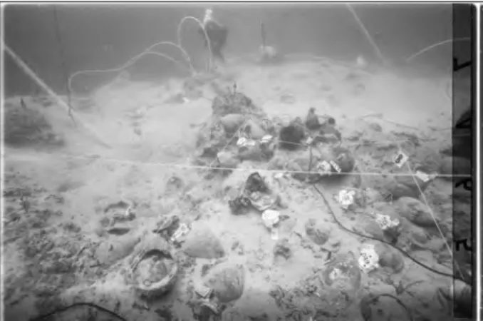
Maritime archaeology, like computing science, is a relatively new discipline that, likewise, evolved dramatically throughout the 20th century, a time when hard-hat divers, under the direction of archaeologists on the surface, investigated ancient wreck sites. The Antikythera site, off the island of Antikythera, Greece, is probably the most famous example of this ‘primordial’ underwater archaeological research: there, a large number of bronze and marble statues dating from the first century BCE were recovered with such arrangements in place. Oddly, a device now recognised as an ancient analogue computer, the Antikythera Mechanism, was recovered at that site (Freeth and Jones 2012).
It was only with the invention of the aqua-lung and the development of diving sports that working underwater became feasible for archaeologists. From the onset, the problem of working underwater was that time is of the essence: the air in the tank is finite, and the deeper one operates, the quicker the air is used up. In addition, the effects of breathing air under pressure have two limiting side effects: nitrogen narcosis, which affects the diver’s ability to operate at depth, and decompression sickness, which is the problem of dissolved gasses in the body. This requires lengthy decompression in shallow water to allow them to be flushed from the system. Working underwater has also limitations caused by Corresponding author:
cold water, currents and the lack of ability to talk to others working with you. All this has resulted in the archaeologists having to find ways of being as efficient as possible underwater (Bass and Katzev 1968).
Archaeologists involved in the underwater world do not have the same advantages as their terrestrial counterparts. Searching for archaeological sites underwater is often difficult and complex for the obvious reason that one cannot spend an indefinite time there. Visual searches are feasible in very shallow water. In deeper water a submersible can be used. However, these methods are either time consuming or expensive. As a result, there is a reliance on remote sensing as a cost-effective alternative. Such technique, widely used in the minerals and oil exploration field, can be operated 24 hours a day and – under certain conditions – is extremely effective in locating underwater archaeological sites. This paper outlines the developments in the field and point to the way the field is developing.
2. Position Fixing
In the past, position fixing at sea has been extremely complex. Close to shore it was possible to use land transits or horizontal sextant angles (Green 2004, 34). Further out to sea, out of sight of land, it became more difficult, even using a variety of radio and radar based systems, which in any case were either very expensive to operate or gave poor
Jeremy N. Green
Western Australian Museum, Australia
Abstract:
Since the 1950s there has been a steadily increasing use of computing in the field of underwater archaeology. This has been driven by the need to utilise time underwater as efficiently as possible. The development of applications originally created for the offshore gas and oil industry has provided devices and computing applications that can be utilised in the archaeological domain. This paper deals with some of the advancements in computing application for underwater surveying and underwater cultural heritage management.
Keywords:
Across Space and Time. Papers from the 41st Conference on
Computer Applications and Quantitative Methods in Archaeology. Perth, 25-28 March 2013
accuracy. With the advent of the Global Positioning System (GPS), site positioning has changed radically. It is now possible to locate one’s position anywhere on the surface of the Earth to about ±2.5 m using a small hand-held instrument; with more complex systems this can be reduced to sub-centimetre accuracy. For an archaeologist, on the surface of the sea, a precision of ±2.5 m is generally more than adequate as the sites are often tens of meters below the surface, so even the ability to easily return to a site is an enormous bonus. What has not yet been satisfactorily solved is how to connect the seabed to the sea surface, so that the underwater position can be accurately recorded via the GPS. The GPS is also vital when operating remote sensing equipment because it provides a constant stream of position data necessary to georeference the remotely sensed data.
3. Magnetometers
Magnetometers were first used in an underwater archaeological context to search for shipwrecks in the sixties (Hall 1966).
This author was involved in magnetometer surveys of two shipwreck sites, the Amsterdam, a VOC (Verenigde Oostindische Compagnie or Dutch
east India Company) vessel wrecked in Hastings (UK) in 1749 (Marsden 1985) (Fig 1) and the Greek 4th century BCE Kyrenia shipwreck in Cyprus (Green, Hall and Katzev 1967) (Fig 2). In these sites, the magnetometer was used to plot the extent of the wreck sites.
In the case of the Kyrenia shipwreck –a merchant ship with a cargo of amphorae and other goods – the magnetometer survey was complicated by the fact that the amphorae retain a thermo-remnant magnetic field since the ferrous material in the clay – when fired above the Curie Point (between 858 and 1043°C) – aligns with the Earth’s magnetic field. However, this signal is quite small within a cargo of amphorae since the random stacking will tend to cancel out.
While close-plot magnetometer survey can have specific applications in a variety of situations, its main use in maritime archaeology is in the location of sites. Obviously, large iron shipwrecks are easy to find, as their magnetic signature will be very large. Recently, airborne magnetometers have been used to locate wreck sites and the application of this technique has some interesting implications as described below.
3.1 General marine magnetometers
The first marine magnetometers were based on the proton precession system. They suffered from noise problems in the towing cable and low sampling rate that required a slow survey speed. The advent of high precision marine magnetometers, particularly the overhauser and caesium vapour instruments, has resulted in a great improvement in the efficiency of survey work. These magnetometers have a high sampling rate and a signal to noise ratio
Figure 1. Close plot magnetometer survey of the VOC
ship Amsterdam wrecked on Hastings Beach, UK, in 1749 and surveyed in 1971. The ship outline is in black; the linear feature (grey) represents a buried steel air pipe used to excavate site. The linear anomaly running from bow downwards is possibly a mast. The -1300 NT anomaly (lower right) is possibly an anchor.
Figure 2. Magnetometer close plot of the 4th century BC
Kyrenia shipwreck, Cyprus, showing the anomaly caused by the amphora. Area is 15 m long by 5 m wide.
up to 100 times better that the proton instruments. Additionally, the processing software is now very sophisticated, and can integrate GPS information with the magnetic field intensity and real time plotting of anomalies. Where once the readout was on a paper trace, and the results had to be manually transferred from the plotter, now the entire procedure is digital, with the additional bonus that the position of the vessel – and thus the detector head – can be recorded together with the signal to enable an XY plot to be produced.
3.2 Deep-water location using aerial magnetometer The Deep Water Graveyard off Fremantle (Western Australia) is the site where ships are scuttled after they are of no further use. The sites lie in 80–100 m of water beyond conventional SCUBA (Self Contained Underwater Breathing Apparatus) operations, and initially the position of the wreck sites were uncertain. An experiment was set up in order to test if an aerial magnetometer might be able to detect sites in the graveyard and a local aerial survey company was contracted to fly two areas: one centred on the Deep Water Graveyard (24 sq. km); the second, further out to sea, centred on the approximate position of HMAS Derwent, a 2100 tonne river class frigate, scuttled in 1994 in 200 m of water (8 sq. km). A team of the University of Technology of Sydney (UTS) flew the area and
undertook the survey at 50 m above the surface of the sea, taking 1 hr 20 mins to survey the first area and about 30 minutes to survey the second (not counting the time to and from the survey areas). The results were surprising. The Graveyard survey showed 10 sites (Fig. 3) and HMAS Derwent showed up quite clearly (Fig 4) in the expected position.
Calculations of the Derwent anomaly (Green 2002) show that the 14 nT anomaly was consistent with the Hall Equation (Hall 1966), which predicted a 16 nT anomaly for the vessel taking into account the length/breadth magnifying effect in the equation:
where ΔM is the anomaly in nanotesla, W is mass in tonnes, D is distance from centre of object
and A/B is the length (A) to breadth (B) ratio.
3.3 Shallow water location with aerial magnetometers
The Correio da Azia was a Portuguese vessel wrecked in 1816 near Point Cloates in the northwest of Australia. It had been the subject of numerous searches, all of which proved unsuccessful. There were two contemporary documents that described the site where the ship was lost, somewhere in close proximity to the Ningaloo Reef system. However, the Ningaloo Reef system is a complex of coral outcrops and reefs that makes conventional searches very difficult, as one has to avoid the shallows. Following the success of the Deep Water
Figure 4. Aerial magnetometer survey showing the site of
HMAS Derwent (lower centre) scuttled in 200 m of water in the Deepwater Graveyard.
Figure 3. Aerial magnetometer survey of the Deepwater
Graveyard off Fremantle Western Australia. Nine magnetic targets correspond with iron ships that were scuttled in waters between 80–100 m depth.
Across Space and Time. Papers from the 41st Conference on
Computer Applications and Quantitative Methods in Archaeology. Perth, 25-28 March 2013
Graveyard aerial survey, at the request of the Western Australian Maritime Museum (Fremantle), a Western Australian survey company, Fugro Airborne Services, flew an aerial magnetic survey over the approximate area where the wreck was thought to lay. The survey successfully identified a number of known sites (Fig. 5), but revealed two magnetic anomalies, close together, indicating that they might be associated with the Correio da Azia (Fig. 6).
Upon inspection of the two magnetic targets, two separate wreck sites were identified. One had coins dating no later than 1816, confirming that the wreck was the Correio da Azia. The other wreck is still unidentified, dating from the third quarter of the 19th century. The Correio da Azia had iron ballasts and two small guns and an anchor (Fig. 7). Similarly, the unidentified site had several large anchors providing a similar sort of anomaly. This project clearly demonstrated that a small site with just approximately a tonne of iron could easily be detected with a low-flying aerial magnetometer, opening the way to further employment of the technique.
4. Metal Detectors
Metal detectors have a limited application in searching for sites underwater because the detection range is relatively small. They are more useful for finding small to medium sized buried objects and for defining the extent of a located site. The most recent underwater metal detectors even have the ability to discriminate between ferrous and non-ferrous material. The metal detector can also be used in conjunction with a magnetometer survey on a wreck site; this combined use of metal detectors and magnetometers was undertaken on both the Kyrenia (Fig. 8) and the Amsterdam wrecks (see above).
Figure 5. Plot showing the area covered in an aerial
magnetometer survey searching for the Correio da Azia lost in 1816.
Figure 6. Plot showing the magnetic targets found in the
search for the Correio da Azia. The large central target has been identified as the Correio da Azia; the smaller target to left is an unidentified late 19th century site; the two other targets are yet to be located.
5. Side Scan Sonar
The side scan transducer emits a fan-shaped pulse of sound that has a narrow beam width in the fore and aft directions and a wide beam width laterally. The fan shaped beam lies in a plane at right angles to the track of the tow-fish and the centre of the beam is directed slightly downward from the horizontal toward the maximum anticipated range. Nonlinear time-variable amplification enhances the signals coming from distant objects and compensates for strong near-field signals. The unit records the intensity of the return of the time-variable signal.
In the case of a towed fish, the trace displays three elements: the seabed, the water surface and a shadow picture of the seabed. Interpretation of the record is often quite complex and the side scan is best operated over a smooth sandy seabed in flat calm conditions. The system is generally interfaced with a GPS, so that the image trace is created to scale usually on an underlying map. As the sonar image is to scale, the trace of the target can be measured and its dimensions determined without having to dive on it (Figs 9–10).
Where there are rocks, the signal from cultural remains – even quite large iron wrecks – are difficult to detect. Additionally, if there are any swell or wind-blown waves, this can cause the fish to yaw and create surface return noise that obscures the bottom trace. Thus, at times, even very large sites can be
Figure 9. Side scan sonar trace of the Sapporo Maru,
Truck Lagoon. This vessel was one of the few vessels that had not been found and this sonar trace was the first indication of the vessel since its loss in 1944.
Figure 8. Kyrenia shipwreck showing the combined
magnetometer and metal detector surveys allowing discrimination of non-ferrous material (lead sheeting). Z1 and Z4 are ferrous targets, the rest are non-ferrous.
Figure 10. Plan of the Sapporo Maru from Bailey
Across Space and Time. Papers from the 41st Conference on
Computer Applications and Quantitative Methods in Archaeology. Perth, 25-28 March 2013
missed due to these effects. Most side scan sonar systems that can be deployed from a small boat by hand have ranges up to about 500 m on either side of the fish. The range is related to the frequency that the transducer operates: the higher the frequency, the shorter the range, but the higher the resolution. Thus a 150 KHz system usually has a maximum range of about 750 m and is able to detect objects about 0.5 m in size. A 900 KHz system would have a range of about 50 m and a resolution of about 1 cm. The side scan sonar can be highly sophisticated deep-water systems that are extremely expensive, weigh hundreds of kilograms and require deck winches.
One of the most interesting developments with side scan sonar is the ability to georeference the sonar images. This means that – as the side scan sonar is constantly monitoring position – the location of the source of the sonar image is known for each sonar “ping”, given that the beam extends outwards, but is extremely narrow in longitudinal direction. As the course is known, the azimuth or direction of each narrow beam sonar ping is known. Since the range is also known, it is possible to track the path of the sonar sweep (Fig. 11). For each point on the graphic image of the seabed that is output from the side scan sonar, a precise location can be given. With additional processing it is then possible to take the graphic image (usually a tiff or jpeg file) and georeference it. Thus, when the image is displayed, it is shown in its correct orientation.
6. Multibeam
A recently developed system for surveying the seabed is the multibeam sonar. This system is widely used in hydrographic survey work but, although excellent for logging the depth of large areas of seabed, its underwater archaeological applications are limited (Fig. 12). Multibeam sonar systems transmit a fan-shaped acoustic signal similar to that of the side scan sonar. Instead of continuously recording the strength of the return echo, the multibeam system measures and records the time for the acoustic signal to travel from the transmitter (transducer) to the seabed (or object) and back to the receiver. The system has a large number of receivers that record the angle of arrival of the signal; the system then calculates the depth at seabed from the time and the angle of return of the signal. Multibeam sonar systems are generally attached to a vessel rather than being towed like a side scan, so it is also necessary to be able to precisely measure the motion of the sensor relative to the surface of the earth. The coverage area on the seafloor is dependent on the depth of water. Typically the greater is the depth, the less is the resolution; for example, in 200 m of water it is just possible to determine the outline of a large ship. The multibeam can be used to generate a three dimensional image of the seabed features and create depth contour plots or alternatively an image of a wreck site.
Figure 11. Sonar mosaic superimposed on a GIS showing
the North Mole Barge, off Fremantle, Western Australia.
Figure 12. A multibeam image of HMAS Derwent in 200
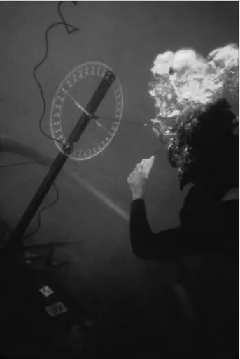
Figure 15. A simple underwater theodolite being used to
record a site.
Figure 13. Simple trilateration on a wreck site using tape
measures.
Figure 14. A simple angle measuring device being used
to record the hull of a shipwreck.