__________________________ * Corresponding author
LOW-COST TECHNOLOGICAL IMPLEMENTATIONS RELATED TO INTEGRATED
APPLICATION EXPERIMENTS.
C. Palestini1*, A. Basso2
1Dipartimento di Architettura, Università degli Studi “G. d’Annunzio” Pescara, Italia, 2 Free University of Bozen, Faculty of Education
[email protected] - [email protected]
Commission II
KEY WORDS: Virtual Survey, Low Cost, Photogrammetry, 3d model, Heritage Interpretation.
ABSTRACT:
Thanks to the development of new Cuda technologies applied to graphics cards and to a more accessible and growing use by professionals in various commercial, artistic and research sectors, the latest generation digital instruments have implemented new methods of photogrammetric surveying and remote sensing, progressively reducing the cost of the instruments and that related to the application development of the different SfM algorithms, now widely used also in numerous open source software. The research presented in the article compares two of the most recently used free programs with the most satisfactory results in the field of 3D photogrammetric survey and photomodelling: Meshroom, developed by AliceVision and Regard3D, an open source software, compiled in 2015 by the Swiss IT engineer freelance Roman Hiestand. The test case study will concern the photo-modelling, through the free tools previously discussed, of medium size complex decorative details, one of the monumental gates of the ancient Roman city of Sepino, an archaeological site in Molise (IT) located at the foot of the Matese and extending over the Tammaro valley, so as to be able to fully test the capture characteristics and the trend and structure of the pipeline of the two software examined.
1. INTRODUCTION
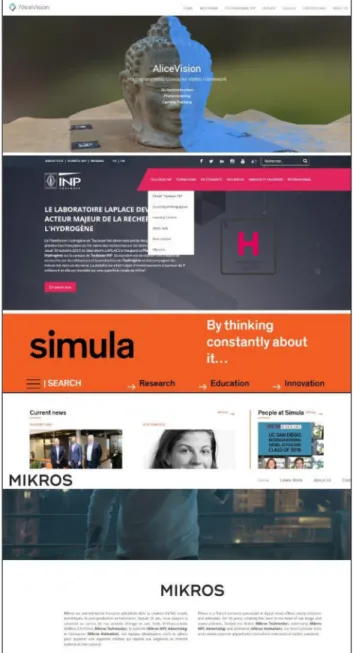
Regard3D, compiled in 2015 initially to test the algorithm MVG 0.8.1, at the hobby level by the Swiss IT engineer freelance Roman Hiestand, with a focus on cross-platform development with C / C ++, machine vision, multi-threading, scientific computing and information security, together with Meshroom, developed in a much wider field and with more actors involved, are two tools that work mainly by tracing the workflow and methods of operation of their commercial counterparts, such as Agisoft Metashape or Pix4D, but being open source are, although less stable, much more versatile and configurable in terms of programming depending on the intended uses. The reasons that can explain why this new generation of tools works so well and is so versatile in dealing with surveys at very different scales, lies in the fact that they are the result of collaborations between academia and the commercial industry. For example, AliceVision has always had the objective of disseminating advanced algorithms, compatible with computer vision, which can be tested, analyzed and reused alongside business collaborations, such as Mikros, a French company specializing in the creation of digital visual effects, post-production and animation or the private research laboratory SIMULA, which deals with teaching and scientific and technological production, with public and academic organizations such as the National Polytechnic Institute of Toulouse (INPT), which since 1969 is an important French university cluster, or as the University of Prague Czech, in order to create a three-dimensional open source photogrammetry software, MeshRoom, used in the research in question. The company has been releasing an innovative open source SfM pipeline, called openMVG ("Multiple View Geometry"), since 2013, providing the basis for a better solution for color homogenization in multiple photo libraries for photogrammetry. In 2015, Simula, Toulouse INP and Mikros Image joined forces in the EU's POPART project to create a Previz system based on AliceVision's expertise. In 2018 was born
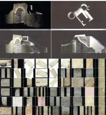
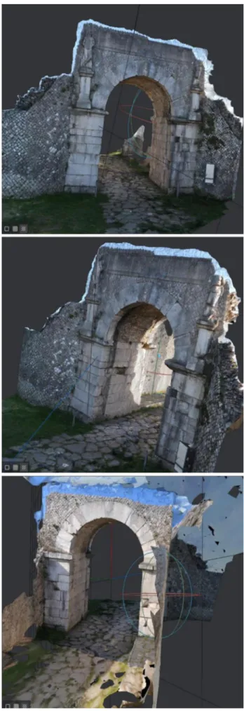
Figure 1. Sepino Bojano Door reconfiguration and photo documents
thus MeshRoom, a real free tool for 3D photomodelling and automodelling from Stucture for Motion algorithm (Uebel, 2019). The ease of use of this program, thanks to a convenient node editor in which the pipeline is organized graphically-visually, and therefore in an intuitive way, has brought newbies very close to the methods of photo modeling, without excluding the most experienced users, able to obtain from the program more accurate results and performance through the use of hidden functions. For example, by choosing the texture node within the The International Archives of the Photogrammetry, Remote Sensing and Spatial Information Sciences, Volume XLII-2/W17, 2019
Figure 2. AliceVision, developer of open source software Meshroom and its research and development partners from commercial companies and public academic organizations.
branched workflow it is possible to set the resolution of the texture map according to the export, from the game on mobile platform to the high-resolution rendering. Logically, it is very important to spend some time to understand the node editor system, which guarantees an optimal result in the definition of the polygonal model obtained. Autodesk Maya users can also use an App directly within the famous 3d modeling and animation software as a free plugin also available directly on the website. Regard3D is the other program analyzed and compared in the article. Unlike MeshRoom it is slightly more complex because of an outdated, unkept graphical interface and a less versatile management of the different phases of work. Its sophisticated feature set is mainly suitable for professional or academic users, although it may also be accessible to general users, resulting in less detailed three-dimensional mesh models. Regard, born exclusively for personal testing research and later constantly improved thanks to a constant didactic and research experience; it has proved to be a versatile tool that has long been used with good results in fields such as environmental protection, medicine, cartography, cultural heritage and private industrial and
commercial development. By using Regard3D, it is possible to generate 3D models and spelling plans. In addition, the SfM algorithm that regulates the association of homologous points and the phases of mesh creation is able to handle any type of object at any scale size. It can detect large plots of land as well as scan small objects. It can process images at close range and aerial drone shots. Some of the editing tools provided even make it a viable solution for metrology and archaeological site detection. The case study will concern the photo-modelling, through the free tools previously discussed, of medium size complex decorative details, one of the monumental gates of the ancient Roman city of Sepino, an archaeological site in Molise (IT) located at the foot of the Matese and extending over the Tammaro valley, so as to be able to fully test the capture characteristics and the trend and structure of the pipeline of the two software examined. Moreover, the processing times used to obtain the configurate digital models will be calculated and then compared both in relation to the plasticity and topology of the mesh and in relation to the restitution of the chromatic component. From the results of the comparison between the two software analyzed it is clear that although Regard3D is much faster, the best results were obtained with the digital reconstructive method adopted by MeshRoom, from which it was possible to define a mesh from the triangular topology more homogeneous in the format .obj, much more suitable for 'export to multiple external 3d graphics platforms.
2. THE USE OF OPEN SOURCE SOFTWARE FOR DIGITAL SURVEY AND DOCUMENTATION OF THE
HERITAGE.
In recent years, the documentation of Cultural Heritage has become the subject of interest and study by several researchers who, in view of new technological developments and the spread of new communication media, have focused on the development of open source software for new methodologies of applied digital survey, and for the popular rendering aimed at the transmission of information to a wide audience. The documentation and the digital archive of the Heritage have therefore made use of tools that are often developed ad hoc in the same project and then released in a freeway to be used in other projects and for other entities of documentation. The computer compilation of free/open source software is not exempt from some problems since the development process is partly different from that of the commercial counterpart; the project entity cannot have a consistent complexity so as to allow a development and maintenance of a small team, or, if it encounters structural problems of editing and management, it needs economic and logistical support from external actors, such as research projects in active collaboration with public and private universities, commercial sponsors or calls for participation in international open competitions, creating products that are released / opened, or simply released under a license approved by the OSI (https://opensource.org/licenses). In these cases, the main problem lies in the long-term maintenance of the algorithms used in the software. Even a few years after release, if the application is not acquired by large companies through sale, the difficulty of low priority maintenance and software upgrade by the small team increases, correcting small bugs and making small changes, but ignoring large improvements as they are almost impossible to carry out. A direct consequence of this situation is that many interesting independent research projects flow into a rather neglected state and are often abandoned altogether. Very large projects, although created with the aim of being aimed at a free user, can instead afford the support of a large community, relying on the loose support of many individuals and including the involvement of collaborative structures resulting from university The International Archives of the Photogrammetry, Remote Sensing and Spatial Information Sciences, Volume XLII-2/W17, 2019
research bodies, for example by separately assigning lines of calculation scripts as tests to students in a course of Computer Graphics or Computer Engineering. Assuming a Virtual Survey operation as a cognitive intervention of the existing architectural structure for the purpose of archaeological and architectural investigation or use in informative and museum setting projects, the technical application tools are multiplied with the main prerogative of a non-invasive investigation, respectful of the artifact or place of investigation. Compatible with this strategy of intervention, applications of 3D photogrammetry are gradually spreading, more and more accessible and easy to use, which can produce, thanks to the acquisition of photographic data, image-based survey, clouds of 3D points capable of returning a model of the object detected, together with the possibility of intervening digitally with spatial modification without altering the original structure, thus tending to intervene crosswise, in line with current trends of environmental sustainability and economic savings. The realization and diffusion of new low cost tools such as Microsoft Kinect or new double chamber smartphones with RGBD depth sensor (Lee & Medioni, 2014) has triggered a process of price cutting not only of professional 3D photogrammetry software such as Pix4D or Agisoft Metashape, but also in relation to hardware such as Drones and Laser Scanners, until a few years ago very expensive instrumentation and certainly not affordable for everyone. This is certainly an advantage, both in terms of simplifying employment, since open source software is often the result of independent work that proceeds in parallel with other uses, and in terms of developing new forms of work aimed at creating a parallel digital architecture as specific programmers, virtual modellers, architects or even archaeologists specialized in the analysis and study of computer cloned artifacts (Palestini & Basso, 2017). For several years now, open source photo modelling tools have been applied to practical examples presenting applications of photographs for 3D photogrammetry of cultural heritage objects (Kersten, 2015) in which results from the use of open-source programs in combination with point clouds obtained through laser scanning often work in an integrated manner. All 3d photomodelling software, whether low cost or commercial, follow the Structure for Motion approach, (SfM1 ), based on the acquisition of data in photomosaicatura, following mainly the two most common methodologies, technique to "parallel scan" and "photocentric" in which a certain level of overlap between the images is fundamental: The image mosaic is therefore defined as the process of obtaining a wider field of view than a scene by means of a sequence of overlapping partial views. The rectified image is finally generated through an option resampling process (Remondino et al, 2014). The possibility to generate low cost and relatively quickly three-dimensional digital models through open source tools hides some critical issues inherent in the same topology of the autogenerated model, which, although it can be used for a virtual visualization, cannot provide a millimeter accuracy required for a morphological documentation of an artifact, which can be obtained more easily with methods based on the range as the laser scanner. In general, free software is particularly sensitive to the different lighting conditions at the time of taking pictures and often cannot separate for example elements of vegetation that can partly obscure the scene, in the case of a few inches of decorative details, the self-generated meshes do not provide a return of perfect shape, however, it is possible to treat individual elements separately to obtain a better
1One of the most common algorithms in this field is the SFM (Structure from Motion) algorithm (Agarwal et al., 2011). For this purpose, an archive of images of the scene is necessary. In the SFM method, a large number of images are oriented without any knowledge of the camera's internal parameters (Barazzetti,
result, later joining the generated cloud points. One of the factors influencing the accuracy of the model obtained in image-based methods is the software, the photo sensor and the algorithm used to generate the three-dimensional model. Considering the speed of change in the software market however, we can expect an improvement in the alignment and meshing algorithms used in various open-source software, meeting current expectations for accuracy and improving the efficiency of the entire modelling process. It is obvious that commercial software packages are better than free ones in 3D but this software can find many other types of applications that do not require high accuracy compatible with the preservation of the Heritage and its disclosure. Research has shown, however, that even using open-source software it is possible to obtain 3D models of the structures properly accurate (with an accuracy of just a few centimetres of error), but for the purposes of documentation and conservation of cultural and historical heritage, this precision may be insufficient if it is aimed at direct restoration work on the artefact itself.
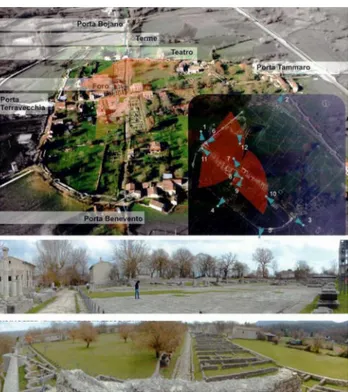
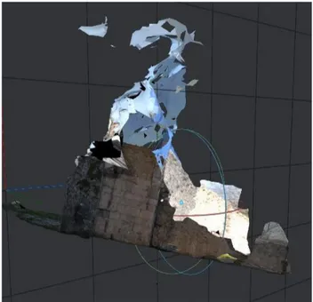
Figure 3. Sepino, analysis site and docu photo survey.
3. HISTORICAL OVERVIEW OF THE ANALYSIS SITE.
The case study examined an archaeological artifact, the monumental Bojano door, an element of the ancient Saepinum in Molise. The traces left by the Roman city are still present in the site where initially stood a fortified settlement of the Samnite era, placed in a strategic network of trade defined by transhumance. The surveys and investigations conducted with low cost systems are useful for reconfiguring three-dimensionally the layout and image of the ancient city with its significant spaces: the forum and the basilica, the theater, the baths and the turreted perimeter walls. The current archaeological site shows its expansion, the urban extension dating back to the Augustan period that enclosed
Scaioni, & Remondino, 2010). The orientation of the images is automatically performed through a series of specific points with identical characteristics. A most used operator in this process is SIFT (Scale Invariant Feature Transform).
The International Archives of the Photogrammetry, Remote Sensing and Spatial Information Sciences, Volume XLII-2/W17, 2019 6th International Workshop LowCost 3D – Sensors, Algorithms, Applications, 2–3 December 2019, Strasbourg, France
it within a wall defined by a powerful defensive system, consisting of 29 towers, of which today there are some portions, finds, traces more or less labile, incorporated into subsequent buildings. Analysing the foundations ( Conventi, 2005), based on the classic intersection between cardoon and decumanus that in the case of Sepino are not orthogonal to each other, but follow the inclination determined by the ancient crossings of the site, has been reconstructed the urban model compared at a modular level with that of other cities of Augustan foundation. The investigation was then carried out considering in parallel the historical testimonies (Cianfarani, 1958), iconographic and archival documentation, collated on the archaeological finds examined through surveys and graphic readings that have allowed to formulate a plausible reconstructive hypothesis on the original appearance of the places. Starting from the main city gates, brought to light and reconstituted thanks to the interventions of the Archaeological Superintendence of Molise, they marked the accesses to the city, tracing the main directions of connection in the territory. To the north-west we find Porta Bojano, located on the axis of the decumanus, which contrasts, to the south-east, Porta Benevento and transversally, on the cardoon, Porta Tammaro facing north-east towards the river of the same name, mirrored by Porta Terravecchia that descends towards the lands to the south-west. Porta Bojano preserves the planimetric layout typical of the openings of Sepino with obvious slight adaptations imposed by the topographical situation and the exposure of the door: the only arch corresponds to an internal courtyard of security, concluded towards the city by a double leafed counter door flanked by two circular towers in opus reticolatum. On the outside, the two statues on either side of the arch represent barbarian slaves and are well preserved. The descriptions reported, obtained from surveys and analysis of the state of fact, have allowed the comparison of the historical evolution, analyzed through the drawing. The virtual survey, in conclusion, offers a useful key to understanding and enhancing the archaeological site, so it is possible to propose an information system and multimedia display that leads from the imprints virtually to the reconfiguration of the spaces, explorable with films and representations inserted in special databases.
4. TWO FREE SOFTWARE COMPARISONS. TEST FOR THE CASE STUDY.
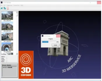
To deal with the case study of the relief of the Bojano door, an artefact of medium complexity that still has interesting features, such as some round sculptural parts on the sides, a bas-relief engraving and the use of the opus reticolatum, are so selected some open source software that in recent years are the most used, as already written in the introduction, Regard3D (Regard3D,2019) and Meshroom software, since they both rely on an easy workflow, one for consecutive phases and the other through a comfortable graph node through which connect all the steps to generate a 3d model from photographs (Uebel, 2019). In the testing phase for both free software the same dataset images were used, reaching at least 60% overlap between each two consecutive images, a percentage that in commercial programs can be lower but in open source software is identifiable in this measure if you want to achieve satisfactory results. In the selection of free programs to be included in the experiment, in a first phase, the possibility of introducing an open source software that until recently was used a lot in academia for photo modelling was explored, taking advantage of the potential of cloud computing to remotely calculate the point cloud through external servers, due to an insufficient computing capacity of past generation PCs: 3DArch. To make the program work it takes an interchange of data between the user, client, and the server. The
Figure 4. Arc3d loading photo dataset.
user has the possibility of uploading photographic data, which once authenticated are processed in remote system, and can perform the function of model-viewer when the EPOCH server in ESAT returns the complete model. The system, as the most famous paid software Recap3d, has some limitations related to the interaction on the workflow process for obtaining 3D models made with the web application (Vergauwen, 2006), because the user's interference in the entire process is quite low. The project to use 3DArch among the testing programs was then abandoned for the reasons mentioned above but also because of the updates of other open source software for photo modelling that are based on the exploitation of new computing potential of the PCs thanks to the implementation of graphics cards to support cuda, making up for the waiting time for downloads and uploads that were too long and provided rather disappointing results compared to the results of the latest generation of open source software. Moreover, the impossibility to intervene directly in the various editing phases without involving external programs led to the use of other solutions. Regard3D, now in version 1.00 of 2019, with the upgrade of the system OpenMVG 1.4 and OpenCV 4.0, comes with the following third-party programs:
- MVE, Multi-view environment, moving scale surface reconstruction and texture reconstruction. It contains an implementation of the patented SIFT algorithm but is only used in the sfmrecon program that is not included in Regard3D. The texturing subprogram has a dependency on the library coldet, which is released under the GPL license.
- CMVS / PMVS2 (Clustering Views for Multi-view Stereo) by Yasutaka Furukawa and Jean Ponce, are released under the GPL license.
- PoissonRecon, used in many free software, such as Cloud Appears for example, is released under the BSD license, the algorithm is critical for meshing from dense point cloud. - SMVS, (Shading-aware Multi-view Stereo) originally from OpenSfM, used to obtain an excellent regularization of surfaces and save detail using normal maps of images.
For each image, the software automatically detects key points which, having particular characteristics, have a high probability of being found in other consecutive images of the same object, such as corners, edges, etc., too. Regard3D, but also Meshroom, uses Normal or Fast A-KAZE for this purpose. For each function, a mathematical descriptor is calculated that identifies the same point in different images (seen from different points of view). The homologous points identified in the different pairs of images are combined and filtered geometrically. The result of this step is a collection of correspondences between each pair of images.
The International Archives of the Photogrammetry, Remote Sensing and Spatial Information Sciences, Volume XLII-2/W17, 2019 6th International Workshop LowCost 3D – Sensors, Algorithms, Applications, 2–3 December 2019, Strasbourg, France
Figure 5. Schematic Regard 3D Workflow.
In this regard, Regard3D uses Liop (Local Intensity Order Pattern). Now the "tracks" are calculated. For each function that is part of a match in a pair of images, it is also searched for in other images. A trace is generated by features if these features meet certain conditions, for example a trace is displayed in at least 3 images. Il Matching algorithm di default is the FLANN but there are alternatively the KGraph (fast, medium, precise): this algorithm is based on the "small-world" algorithm. It gives very good results but is slower than FLANN. Then there is the Brute force method, but it is very slow and the MRPT: this algorithm is based on random projections. It gives good results and is sometimes faster than FLANN. For those of you who like to experiment, it might be an alternative. The next step is triangulation. All the matches of all the pairs of images are used to calculate both the 3D position and the characteristics of the "camera", i.e. where each image was taken and the visual characteristics of the camera: the 3D position of each "track" is thus calculated and the result of the triangulation phase is a sparse point cloud. To obtain a denser point cloud ("densification"), it is possible to use the different algorithms mentioned above, e.g. CMVS/PMVS. The last step is called "Surface generation". Point clouds are used to generate a surface, with vertex color characteristic or with Texture on UVMap projection, the PoissonRecon algorithm is used. The structure of the software is quite linear but not very attractive. Automatic modeling proceeds by offering many customization possibilities to improve the model but there is little intuitiveness in the general management of the workflow, which for inexperienced users can be uncomfortable by making attempts to obtain a good 3d model. Meshroom, on the other hand, turns out to be a really interesting software with innovative features, despite using essentially the same open source algorithms common in other three-dimensional photogrammetry applications. The various phases of the workflow are structured through a graphic-node editor that allows for an easy management of each step in a rapid manner. The visual interface is suitable for different levels of professional knowledge, from the already pre-compiled standard, which
Figure 6. Regard3d Interface. Point cloud Densification and polygonal model with vertex color.
allows anyone to use Meshroom without the need to modify anything, to a completely configurable structure based on creative needs. The first phase of workflow is the classic image acquisition where the quality of the footage is the most important and challenging part of the process. It has a very substantial impact on the quality of the final mesh. Shooting is always a compromise to meet the objectives and constraints of the project: scene size, material properties, texture quality, shooting time, amount of light, variable light or objects, photo sensor quality and settings. The main objective is to have sharp images without motion blur and without depth blur. So tripods or fast shutter speeds should be used to avoid blurring, reduce F/number for great depth of field, and reduce ISOs to minimize noise. The software seems to work better with fewer high resolution images, as it is able to detect pairs of homologous points very well. Meshroom is designed to easily get a 3D model from multiple images with minimal user action. The node system exposes all the steps of the photogrammetry pipeline as nodes with configurable parameters, while all the steps will be recorded by the program and saved in a folder "Meshroom Cache", the position of the cache is indicated in the status bar, at the bottom
Figure 7. ImageMatchingMultiSfM algorithm. Polygonal self-generated mesh model
The International Archives of the Photogrammetry, Remote Sensing and Spatial Information Sciences, Volume XLII-2/W17, 2019 6th International Workshop LowCost 3D – Sensors, Algorithms, Applications, 2–3 December 2019, Strasbourg, France
Figure 8. Meshroom fluid workflow. Image Viewer and Akaze algorithm pixel auto-matching.
of the window. The software is based on a database of camera sensors to determine the camera's internal parameters and group them together. If the images lack metadata and/or were taken with a device unknown to Meshroom, an explicit warning will be displayed explaining the problem. In all cases, the process will continue, but the results may be degraded. Fortunately, for the case study, the metadata is clearly recognized, the photos were taken with a NIKON D5000 sensor in the database. Once the node graph is structured, you can proceed gradually, processing the calculations node by node for each step of the process, and in the event of changing the parameters, or you can proceed by calculating all together for a final result, obtaining the complete mesh model. The generic pipeline for photogrammetry also in Meshroom consists of two main phases:
- SfM: Provides the rigid structure of alignment of the scene (3D points) with position and orientation of the objects filmed and the internal calibration of all cameras. The result is a set of cameras calibrated with a scattered point cloud exportable in Alembic file format.
- MVS: The MultiView-Stereo (dense reconstruction) uses the calibrated Structure-from-Motion cameras to generate a dense geometric surface. The end result is a structured mesh that can be exported in OBJ format with the corresponding MTL and texture files.
The visualization of the 3D assets of the scene in mesh surface with texture can finally be loaded with the command "Load
Figure 9. definitive 3d model with texture from Meshroom. The International Archives of the Photogrammetry, Remote Sensing and Spatial Information Sciences, Volume XLII-2/W17, 2019
Figure 10. Meshroom 3d mesh model. No optimization
Model" in the lower part of the 3D Viewer even if it is already saved, once calculated, in a folder of the Cache: it is possible to click with the right mouse button on a support and select "Open folder containing" to recover them. We can also choose a photo in the "Images" panel to see the corresponding camera in the 3D viewer and vice versa through a synchronization system between the two panels. Meshroom also offers some internal post-production systems, although much can be done on other open source software that modify and improve the Mesh, such as Meshmixer, Instant Mesh and MeshLab, the nodal system can be used to add a new process to the default pipeline "MeshDecimate". The goal of this step is to create a low-poly version of our model using automatic mesh decimation. For the case study aimed at the photomodelling of the Bojano arch composed of a decorative apparatus, statues and typological characteristics of the arches, external parts and an intrados, it was necessary to add blocks of images separately, as is done with the addition of chunks in Agisoft Metashape, so that the software, using not only the standard SIFT algorithm but also the new AKAZE algorithm, was able to recognize more than 50000+50000 points per photo, to be combined as homologous points for pairs of consequent photos, as well as recognize the metadata of each shot that helped in the reconstruction of the scattered point cloud.
The result was excellent, the model was complete in all its parts and the reconstruction had very few gaps, then corrected with Autodesk Meshmixer in a second time. The models resulting from the digital self-modelling processes from Regard3d and Meshroom, were exported with the textures on an interactive visualization platform like Twinmotion in order to be able to fully view the status and polygonal requirements of the meshes and the quality of the textures generated with different projection modes. The Meshroom model is formally superior to the one generated by Regard3d, while Regard 3d offers slightly better results in terms of texture quality.
5. COMPARE RESULTS.
Evaluating a millimetric geometric correspondence of the generated 3d models is important with the objective of a direct restoration intervention on the structure but secondary if the aim is the didactic documentation and the visual graphic definition of the form to be used in a heritage education project. Adopting an
Figure 11. Autoderk Meshmixer editing workflow for corrective postproduction_hole auto filling.
Figure 12. RTR Twinmotion 3d viewer, Unreal Engine 4 for visualization.
approach without scaling, we compared the result obtained by open source tools with that obtained by a previous experiment using one of the most complete and used commercial software, Agisoft Metashape. The largest dense point cloud (generated by Metashape) has been considered as a cloud of reference points. In a first phase, each point cloud was manually approached to the reference cloud with the option "Align (pairs of picking points)' of the open source software CloudCompare, very useful tool to The International Archives of the Photogrammetry, Remote Sensing and Spatial Information Sciences, Volume XLII-2/W17, 2019
generate important processes such as triangulation and meshing, also used to process point clouds from laser scanners.
This manual phase is possible thanks to the visible control points. In a second phase, Cloud Compare's internal plugin M3C2 directly calculated the distances between overlapping point clouds. In the output section, the projection method of the fundamental points
is done keeping the original; in this way, a new cloud is generated, containing the differences between the point clouds tested (Gagliolo, 2018). The two solutions show an error of correspondence with the point cloud of the commercial software Agisoft (1.68051e-006): -0.0215 for Regard3d, and -0.0002 for Meshroom, demonstrating a slightly greater reliability of the 3d model generated with the AliceVision software. In summary, the Meshroom model is better than the one generated by Regard3d even if at the level of processing time Regard3d is much faster than Meshroom, with the same data entered and hardware used
ACKNOWLEDGEMENTS
The authors wish to thank in particular Franz Lami for the acquisitions of image-based data.
REFERENCES
Agarwal, S., Furukawa, Y., Snavely, N., Simon, I., Curless, B., Seitz, S. M., & Szeliski, R. (2011). Building rome in a day. Communications of the ACM, 54(10), 105-112.
Cianfarani, V.,1958: Guida alle antichità di Sepino, Roma 1958.
Cignoni, P., Corsini, M., Dellepiane, M., Ranzuglia, G., Vergauven, M., Van Gool L., 2008: MeshLab and Arc3D: Photo-Reconstruction and Processing 3D meshes. EPOCH Conference on Open Digital Cultural Heritage Systems (2008), D. Arnold, L. Van Gool, F. Niccolucci and D. Pleti nckx Ed.
CloudCompare Version 2.6.1 user manual. 2014. http://www.cloudcompare.org (17 March 2019).
Dewitt, B. A., Wolf, P. R., 2000. Elements of Photogrammetry (with Applications in GIS). McGraw-Hill Higher Education.Conventi,M., 2005: Città romane di fondazione, Roma 2005.
Barazzetti, L., Scaioni, M., & Remondino, F., 2010: Orientation and 3D modelling from markerless terrestrial images: combining accuracy with automation. The Photogrammetric Record, 25(132), 356-381.
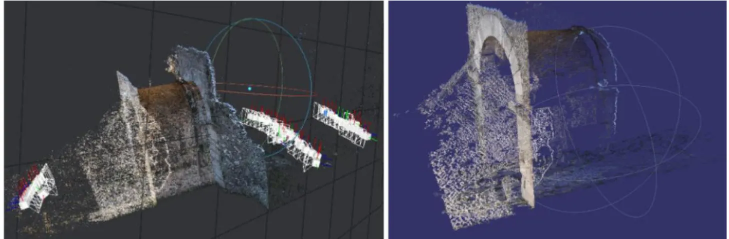
Figure 13. Graphic comparison between the dense point cloud of Meshroom and the dense point coud of Regard3d.
EPOCH: The European Network of Excellence on ICT Applications to Cultural Heritage (IST-2002-507382). More info on: http://www.epoch-net.org/, 2006.
Gagliolo, S., Ausonio, E., Federici, B., Ferrando, I., Passoni, D., Sguerso, D. 2018. 3D culture heritage documentation: a comparison between different photogrammetric software and their products. ISPRS Archives Vol. XLII-2, pp.347-354
Kersten T., Mechelke K., Maziull L., 2015. 3D model of Al Zubarah fortress in Qatar – Terrestrial laser scanning vs. Dense image matching, ISPRS Archives, Volume XL-5/W4.
Lee, Y. H. and & Medioni, G., 2014. Wearable RGBD indoor navigation system for the blind. European Conference on Computer Vision, pp. 493-508.
Luigini, A., Brusaporci, S., Basso, A., Vattano, S., Maiezza, P., Trizio, I., Tata, A., 2019. Digital experience for the enhancement of cultural heritage. VR and AR models of the Valentin im Viertel farmhouse. In T. Empler, A. Fusinetti (a cura di), Modelli e soluzioni per la digitalizzazione. DEI: Roma, pp. 434-450.
Palestini, C., Basso, A., 2017. Geomatics as a survey tool to document and enhance the cultural and landscaped heritage of the monumental complexes in the mountains of Abruzzo, In: ISPRS Archives, XLII-5/W1, pp. 373–380. doi.org/10.5194/isprs-archives-XLII-5-W1-373-2017
Palestini, C., Basso, A., 2017. The photogrammetric survey methodologies applied to low cost 3d virtual exploration in multidisciplinary field, In: ISPRS Archives, Volume XLII-2/W8, 2017, pp. 195–202 https://doi.org/10.5194/isprs-archives-XLII-2-W8-195-2017
Regard3D, 2019. http://www.regard3d.org (3 March 2019).
Remondino, F., Spera, M.G., Nocerino, E., Menna, F., Nex, F., 2014. State of the art in high density image matching. In: The Photogrammetric Record Vol. 29, pp. 144–166.
Uebel, M., 2019. 16 Best Photogrammetry Software Tools in 2019 (6 are Free).
https://all3dp.com/1/bestphotogrammetry-software (20 March 2019).
Vergauwen M., Van Gool L., 2006. Web-Based 3D Reconstruction Service, Machine Vision Applications, 17, pp. 411-426.
The International Archives of the Photogrammetry, Remote Sensing and Spatial Information Sciences, Volume XLII-2/W17, 2019 6th International Workshop LowCost 3D – Sensors, Algorithms, Applications, 2–3 December 2019, Strasbourg, France