Department of Agriculural and Forestry Sciences
PhD in
Sciences and Technologies for the Forest and Environmental Management –
XXVIII Cycle
Scientific Sector-Disciplinary AGR/05
Plant Biodiversity in West Bank: Strategic tools for Conservation and Management
PhD Thesis
Presented by
Dott. ssa NISREEN AL-QADDI
Coordinatore
Supervisor
Prof. Bartolomeo Schirone
Prof. Bartolomeo Schirone
Signature ………. Signature ……….
Tutors:
Prof. Bartolomeo Schirone
Dr. Federico Vessella
Dr. Marco Cosimo Simeone.
Dr. Michela Celestini
This Thesis submitted in fullfillment of requirments for the Degree of Doctor of
Philosophy.
DIPARTIMENTO DI SCIENZE AGRARIE E FORESTALI
Corso di Dottorato di Ricerca in
Scienze e tecnologie per la gestione forestale ed ambientale –XXVIII Ciclo
Settore Scientifico-Disciplinare AGR/05
Plant Biodiversity in West Bank: Strategic tools for Conservation and Management
Tesi di dottorato di ricerca
Dottorando
Dott. ssa NISREEN AL-QADDI
Coordinatore
Supervisor
Prof. Bartolomeo Schirone
Prof. Bartolomeo Schirone
Firma ………. Firma ……….
Tutors:
Prof. Bartolomeo Schirone
Dott. Federico Vessella
Dott. Marco Cosimo Simeone.
Dott.ssa. Michela Celestini
The Phd thesis “Plant Biodiversity in West Bank: Strategic tools for Conservation
and Management” has been defined by Nisreen Alqaddi (Palestine) in June 27,
2016.
The Thesis comitte memebers are:
Prof. Bartolomeo Schirone, Universita’ degli Studi della TusciaDAFNE.
Prof. Maurizio Badiani, Universita’ degli Studi di Reggio Calabria, Dip. di
Agraria.
Prof. Massimo Trabalza Marinucci, Universita’ degli Studi di Perugia, Dip.
di Medicina Veterinaria.
Tutors:
Prof. Bartolomeo Schirone.
Dr. Federico Vessella.
Dr. Marco Cosimo Simeone.
Dr. Michela Celestini.
DEDICATION
This Thesis dedicated to
My Father, who has raised me to be the person I am today, thank you for all the unconditional love, guidance, and support that you have always given me, thank for everything that you have done, you are to me what to earth the sun is. I don’t think that even if I searched the world for
years and years and years I would find someone that is as caring, as thoughtful, and as hardworking as you.
My mother, Thank you for believing in me, encouraging me to do my best and to try new things.I
love myself and I am proud of myself. I have confidence and I believe in myself because of you. Thank you for supporting my dreams and ideas, even when they seem far-fetched or silly to you. I need to make mistakes and have failures to grow, so thanks for being there when I’m down, and
for helping me find my way back up.
My brothers; Ashraf, Mohammed ata and Maen, thanks for your love and encouragement, Thank
you for giving me the confidence not to care about what other people think. I love you so much.
My friends, Thank you so much for walking along in the way of life with me, you have no doubt
made my journey easy, life would have been so boring and exhausting if would have missed your companionship, i would like to say special thank to Maha Kaabne, Rasha Ghrouf, Bassem Abu
Al Rob and Ahmad Al-Ghool
Loving thanks to my for my Aunts, uncle and cousins for your continual love and support Eter Abulicze, who proffered me unconditional love and support. Thanks to be my friend and my
confidant, you have been a great source of inspiration to me.
I would also like to express my sincere thanks to my colleagues in Tuscia University for their
loving care, patience and support along the way.
I would like to thank all my Arabic friends in Italy, who faith in me, support and help.
Yours sincerely Nisreen
i
ادها
ء
أ
يده
اذه
لمعلا
عضاوتملا
ىلإ
يبأ
يذلا
مل
لخبي
يلع
اموي
ءيشب
ىلإو
يمأ
يتلا
ينتدوذ
نانحلاب
ةبحملاو
لوقأ
مهل
:
متنأ
ينومتبهو
ةايحلا
لملأاو
ةأشنلاو
ىلع
فغش
علاطلاا
ةفرعملاو
ىلإو
يتوخإ
يترسأو
اعيمج
مث
ىلإ
لك
نم
ينملع
افرح
حبصأ
انس
هقرب
ءيضي
قيرطلا
يمامأ
اعيمج مكبحا
مكتنبا
نيرسن
ii
ACKNOWLEDGEMENTS
I’m realy grateful to the European Commission for their financial support through a grant
DEBPAL2 project, where the doctoral degree is an integral part of this project.
My special recognition and deep thanks and great gratitude to my university “Al-Quds
University”, which trusted in me and nominated me to get a PhD, so I would like to thank with all my heart all my professors who supported me and helped me with their knowledge, and gave
me their time and efforts to carry out the fields trips, collecting the information; Dr. Jihad Abbadi, Dr. Ibrahim Abbasi, Dr. Khaled Sawalha, Dr. Mutaz Qutob and Dr. Abd Elkareem
Alsharif.
There is a person i need to mention especially, Dr. Ghadeer Omar (AL-Najah University) for her
sincere gratitude and kindness, her useful contributions and support.
I would like to express my cordial thanks and great gratitude to my supervisor Prof. Bartolomeo
Schirone. and my tutors Dr. Federico Vessella, Dr. Marco Cosimo Simeone and Dr. Michela Celestini for their helpful and precious advices, suggestions and guidance for the achievement of
my work, and all the time that they dedicated me, but especially for their kindness, their encouragements and for the confidence that they had in me during all these yrears.
Thanks also go to Dr. Federico Vessella for his supervision, help and assistance particularly
during my stay in Viterbo.
Thanks also to the Tuscia University of Viterbo (Italy) for the opportunity provided to me to
achieve this academic goal.
My sincere thanks and gratitude to the Ministry of Agriculture representative in the staff of
forestry department: Thaer Rabi, Husam Taleeb and Eng.Bassem Hamad.
I wish also to thank all the studenst from Al-Quds University who have helped me in the field
trips Imad AL-Jabali, Mahmoud Aburahmah, shatha Sawallha, Abd Alrahman AL-Moghrabi and Mohsen Sarhan
I wish also to thank Mr. Samih Jarar (National Agricultural Research Center “NARC”), for his
scientific support, as well as his kindness.
Thanks also to the examiners who provided valuable feedback, Prof. Maurizio Badiani and Prof. Massimo Trabalza Marinucci
ABSTRACT
Biological Diversity (Biodiversity), it says, refers to variety in nature, variety within the living world. The term Biodiversity is commonly used to indicate the number, variety and variability of living organisms. The action of management requires capacity of measurement, and measures of diversity only become possible when a quantitative value can be ascribed to them and these values can be compared.
And in Palestine, like other countries of the world the biodiversity conservation has become an urgent need, and it has been preparing this study to introduce a part of the reality of the
environmental situation in general and the reality of plant life in particular in West Bank-Palestine, whereas; the information and data contained in this research constitute an important tool is discussing the problems associated with the environmental realities of biodiversity and the factors that affect it, it is essential to take action in a general way: in order to obtain that
Biodiversity reaches an acceptable level everywhere, globally in the territory, and everyone must learn how to contribute to its preservation and defence by thinking globally.
The most important steps that have been taken to perform this study is select the study areas within the specific criterias (will be mentioned later), collect information of each site before starting the fieldtrips.
Tha main aim of the current studt to set up a wide framework of activities to be inserted as starting point of Guide Lines and best practices to be performed for Biodiversity “inventory” and Biodiversity “strengthening and enhancement with regard to the West Bank, with a specific attention to some areas (selected sites) representative of the main forest environments occurring in West Bank, by providing an ecological description of the investigated species and their habitats, relying on the current data availability to conserve the existing species to preserve the biodiversity through; perceive and understand the status of the main plants species and their distribution in order to protect them, and give warnings and appropriate solutions and/or best practices when any risk act.
For arrivals to achieve these goals is through learning and applying some teaching techniques that will link between reality and science. This study highlights on the environmental situation and the plant diversity in the areas under study (six selected sites) at the level of West Bank, and
it also highlights the plant species characteristic in West Bank, the forests and their types and the deterioration in them and the green area in West Bank.
Based on this study, including those related action plan, analysis and results, put the most important tools (herbarium, seeds bank, GIS and DNA barcode) and select the most important sites that need protection and management in West Bank, this study can be considered as project can adobted by the stakeholders to extend and include all forests and important plant areas.
TABLE OF CONTENT
DEDICATION i ACKNOLEDGMENTءادها
iii ABSTRACT ivChapter One: Introduction 1
1.1 What is biodiversity? 1
1.2 The geopolitical situation 3
1.3 Biodiversity in Palestine (at the level of historical Palestine) 5 1.4 Biodiversity in the Occupied Palestinian Territory (OPT) 8 1.5 Changes in the green cover by human impact, Israeli occupation, and other threats to the biodiversity of species
9
1.6 Forests and protected areas 11
1.7 National Parks, Nature rserves, and Landscape Reserves 14 1.8 The problems and difficulties facing the forest and nature reserves management
in OPT 15
1.9 Aims of the present study 15
Chapter two: Materials and Methods 17
2.1 The work flow 17
2.2 Selected Sites 18 2.2.1. Hebron 20 2.2.2. Salfit 24 2.2.3. Jenin 29 2.3 Herbarium 32 2.3.1. Collecting 34
2.3.2. Pressing and Drying 36
2.3.3. Mounting and fixation 38
2.3.4. Labeling 39
2.4 Seeds Bank 41
2.4.2. Fact sheets on the propagation of trees and shrubs from see 42
2.5 DNA Barcoding 50
2.5.1. Samples used in this study 53
2.5.2. DNA extraction 54
2.5.3. Polymerase Chain Reaction (PCR) 54
2.5.4. Gel Analysis 59
2.5.5 DNA purification 59
2.5.6. DNA Sequencing 59
2.5.7. Bioinformatics tools 59
2.6 Geographical Information System (GIS) 59
Chapter three: Results 62
3.1 Description of the selected sites 63
3.2 DNA Barcoding 101
3.2.1. Markers’ features description 101
3.2.2. GenBank assessment 105
3.3 Herbarium 113
3.4 The integration between Herbarium and DNA barcode 127
3.5 Geographical Information System (GIS) 131
3.5.1. Prediction result of potential distributions 132
3.5.2. Topographic and climatic description 135
3.6 Seedsbank 141
Chapter four: Discussion 143
Conclusion 148
vii
LIST OF TABLES
Table 1 Officially designated forest area in 1971 and 1999.
Table 2 The primers list was used to amplify a DNA barcode region. Table 3 Sample list of all samples were amplified by PCR.
Table 4 The plot area in the southern side of Um Al-tut. Table 5 The plot area in the northern side of Um Al-tut. Table 6 The activities were done in Um Al-tut.
Table 7 The activities were done in Siris. Table 8 The plot area in Siris.
Table 9 Sumarized table of the plot area in Wadi Qana. Table 10 The activities have been done in Wadi Qana. Table 11 The activities have been done in Kherbit Qeis Table 12 The plot area in Kherbit Qeis
Table 13 The activities have been done in Wadi Alquf. Table 14 Plot area number 1 in Wadi Alquf.
Table 15 Plot area number 2 in Wadi Alquf. Table 16 The plot area in Bani Nai’m.
Table 17 The activities have done in Bani Nai’m
Table 18 Molecular results of tested samples with(rbcL, matK, and trnH).
Table 19 Specimens present in GenBank at the species and genus level, and their ability of the barcoding markers to identify the sample
Table 20 DNA barcoding results of the matching specimens in the data set and NCBI data base.
Table 21 Current botanical checklist of all samples were collected from the selected sites.
Table 22 Checklist of forest species included in the Redlist of Palestine (BERC). Table 23 The comparasion between the IUCN redlist and Palestinian redlist Table 24 The integration between Herbarium and DNA barcode.
Salvia fruticosa Mill.
Table 25 Native and protected species retrived and analyzed by GIS Table 26 Seeds collected from selected sites
LIST OF FIGURES
Figure 1 West Bank and Gaza Strip. Figure 2 The Palestinian Territories.
Figure 3 Phytogeographical zones og Palestine.
Figure 4 Landscape units in West Bank as retrived from data by ARIJ Figure 5 The workflow of the studt.
Figure 6 Protected areas in West Bank as declared by Israeli Authorities and the six selected sites have been studied.
Figure 7 Location of Wadi Alquf and the villages all around in West Bank. Figure 8 Wadi Alquf forest.
Figure 9 Location of Bani Nai’m village.
Figure 10 Location of Wadi Qana and the settlement around it. Figure 11 The protected area of Wadi Qana.
Figure 12 Location of Kherbit Qeis. Figure 13 Location of Siris.
Figure 14 Pressing and drying plant specimens to extract the moisture and preserve the morphological integrity of the plants.
Figure 15 Fixed herbarium samples were collected from the selected sites. Figure 16 The definitional card og the herbarium samples.
Figure 17 The general view of the southern slope in Um Al-tut , and tree of Quercus coccefira L.
Figure 18 The proportion of the dominant trees in the selected plot area in the southern part of Um Al-tut.
Figure 19 The general views of the northern slope with Pinus halpensis Mill. And isolated Cupressus sempervirens L.
Figure 20 General view of the Olive trees and the degraded maquis of Quercus coccefira L.
Figure 21 Some dominant species in Siris.
Figure 22 The proportion og the dominant trees in the selected plot area in Siris. Figure 23 The general view of Wadi Qana.
Figure 24 The distribution of Quercus coccefira L. /diameter.
Figure 25 Ratio between the hight and diameter of Oak in Wadi Qana. Figure 26 The risks threaten Wadi Qana.
Figure 27 General view of Kherbit Qeis.
Figure 28 New generation of Ceratonia siliqua L., and Quercus coccefira L. Figure 29 Destroyed Pine trees.
Figure 30 Some plant species grow in Kherbit Qeis.
Figure 31 The proportion of the dominant trees in Kherbit Qeis.
Figure 32 The seedlings which are processed for implanting or distributing to the farmers.
Figure 33 General view shows the western and eastern slops in Wadi Alquf. Figure 34 Some plant species present in the western slope of Wadi Alquf. Figure 35 Some plant species present in the eastern slope of Wadi Alquf. Figure 36 The Cypress trees in Wadi Alquf.
Figure 37 The proportion of the dominant trees in the plot area number 1 in Wadi Alquf
Figure 38 The proportion of the dominant trees in the plot area number 2 in Wadi Alquf.
Figure 39 Results of burning waste in the foret of Wadi Alquf. Figure 40 Olive and Oak trees in Bani Nai’m.
Figure 41 The botanical garden of Bani Nai’m.
Figure 42 Quarries in Bani Nai’m and their affect in the environment. Figure 43 Some plant species present in Bani Nai’m .
Figure 44 The two species were compared with the herbarium sample. Figure 45 Disribution map of native trees/shrubs.
Figure 46 Distribution map of protected trees/shrubs. Figure 47 Frequency histograms of Pistacia lentiscus L.
Figure 48 The bioclimatic variables qualitaviely examined the overlap with historical Palestine.
LIST OF ABBREVIATIONS
ARIJ the Applied Research Institute of Jerusalem BERC Biodiversity and Environmental Research Center BERC the Biodiversity and Enviromental Research Center
bp Base Pair
CBOL Consortium for the Barcoding of Life
CBOL-PWG Consortium for the Barcoding of Life – Plant Working Group
Cm Centimeter
CO1 Cytochrom C Oxidase I gene
CTAB Cetyltrimethyl – Ammonium Bromide DNA Deoxyribonucleic Acid
EDTA Ethylenediaminetetetracetic acid EQA Environment Quality Authority GIS Geographic Information System GPS Global Position System
ha Hectare
IPA Important Plant Area
ISTA International Seed Testing Association
IUCN International Union for Conservation of Nature
Km2 Square kilometre
M Mole
matK Maturase K
MEnA Ministry of Environmental Affairs
Mg Milligram
Min Minute
Mm Millimetre
MTEs Mediterranean – Type Ecosystems NARC National Agricultural Research Center
NGO Non Governmental Organization OPT Occupied Palestinian Territort
PARC Palestinian Agricultural Releif center PCR Plymerase Chain Reaction
PEnA Palestinian Environmental Authority PLO Palestine Liberation Organization RNase Ribonuclease
rpm Revolutions per minute
RuBisCO Ribbulose – 1,5 – bisphosphate Carboxylase/Oxygenase
Sec Second
SP State of Palestine TBE buffer Tris/ Bromide/ EDTA TE buffer Tris – EDTA buffer
UAWC Union of Agricultural Working Committes
1
Chapter one: Introduction
1.1. What is biodiversity?
The word biodiversity is used to explain the variety of life on earth which includes variation at all levels of biological organization from genes to species to ecosystems. This includes diversity within and among species (Shtayeh et al., 2014), (UNEP –Nairobi; 2002, Vere; 2008, Ghattas et al.; 2006)
Biodiversity, is the entirety of individuals of all species combined (animals, plants and micro-organisms) that live and function in the environment, and together with it comprise a functional system, called an ecological system, or “ecosystem.”
Biodiversity is most often understood in terms of the number of species or other taxa and it can be considered at different spatial scales such as Whittaker’s definitions of alpha, beta and gamma diversity (Whittake 1960). Biodiversity is not distributed evenly over the world. (Vere; 2008, Wanjui; 2013)
Humans use the biodiversity directly (includes things like food, fibers, medicines and biological control) and indirectly (includes ecosystem services such as atmospheric regulation, nutrient Cycling and pollination). In view of this, we cannot exist without biodiversity; whereas the biodiversity is actively involved, directly or indirectly, in the provision of all ecosystem services, not only due to the mere size of the species assemblage of each ecosystem, but also, or even mainly, due to the degrees of differences in both form and function among the species within the assemblage (Mutia; 2009, NBSAP; 2007, Wanjui; 2013). These services not only support the functions and secure the daily existence of human beings, but they also sustain the momentum of development, which has accelerated since the agricultural revolution. (NBSAP; 2007)
Global biodiversity is changing at an unprecedented rate; the most important drivers refer to many reasons such as habitat change, climate change, invasive species (the introduction of exotic specie), over-exploitation (unsustainable harvesting of natural resources) (NBSAP; 2007, Mutia; 2009).
The flora of Palestine is estimated to be 114 families, with 2,483 species including 149 endemic species which represents 6% of total flora. The distribution of these species is: 43% are common, 27.5% rare and 25.6% very rare.
2
The term biodiversity refers to the totality of genes, species and ecosystems of a region. Conservation of biodiversity is done in two ways: In-situ and ex-situ conservation, each composed of various techniquies, are employed to conserve genetic diversity: in situ and ex situ conservation.
In situ:
In situ conservation is based on the creation of habitat protected areas that is a forest area evaluated from its present structure, species composition, history and physical environment being of great significance for the forestry flora and fauna. It contains or it is expected to contain red-listed species (Eriksson et al.; 2006, Wanjui; 2013). It is the process of protecting an endangered plant or animal species in its natural habitat, either by protecting or cleaning up the habitat itself, or by defending the species from predators.
The conservation of genetic resources through their maintenance within natural or even human made ecosystem in which they occure.
In the case of non-domesticated species, in situ conservation is probably the most important strategy and sometimes the only viable approach. Where extinction rates of species are high because of land-use changes, setting conservation priorities is critical; this is particularly evident in developing countries, where resources allocated for conservation are scarce and baseline information on species distribution and richness of data are lacking (DEBPAL 2).
1. The conservation within natural or even manmade ecosystem where the organism occur. 2. Conservation in the natural environment itself.
3. Include national parks, sanctuaries, biosphere reserve...etc. Ex situ conservation:
Ex situe conservation means the conservation of ecosystems and natural habitats and the maintenance and recovery of viable population of species and, in the case of domesticated or cultivated species, in the surroundings where they have developed their distinctive properties. These two basic conservation stratigies are further subdivided into specific techniques including seed storage, in vitro storage, DNA storage, pollen storage, field genebank, and botanical garden conservation for ex situ, and protected are, on-farm and home garden conservation of in situ, each techniques presenting its own advantages and limitations (Engelmann et al.; 2002, Wanjui; 2013). The essential elements of ex situ conservation are related to the need to identify, then
3
conserve and manage the range of variability within the species, primarily through the development and management of regeneration, in various forms, in the field. Molecular genetic techniques, primarily with genetic markers, can also help in some of the management tasks for ex situ populations, by confirming the identity of accessions and monitoring genetic changes in collections. However, the allocation of resources in genetic conservation should be need-driven rather than technology-driven.
1. The conservation ouside their habitats by perpetuating sample populations. 2. Conservation in an artificially created environment.
3. Include Zoos, Botanical gardens, Gene banks, Aquarium, and Cryopreservation…etc (Withers; 1993, Wanjui; 2013).
1.2. The geopolitical situation:
Palestine, as it stands now, is divided into two distinct regions covering a total area of approximately 6,065 km2 (606.5 Ha). The larger of these two areas is called the West Bank covering 5,700 km2 (570 Ha), with the Gaza Strip covering only 365 km2 (36500 Ha) (Isaac et al.; 1995, Safar et al.; 2001, El-Atrash; 2013).
Historical Palestine consists of “48 area” (i.e., the land assigned for a Jewish state after the demarcation lines set out in the 1949 Armistice Agreements), West Bank and Gaza strip (Occupied Palestinian territory “OPT”) Palestine (defined here as West Bank and Gaza) lies in the heart of the fertile crescent. These lasts comprise two physically separated land masses (Fig.1). Their total area including the area of the Dead Sea reaches approximately 6221 km2 (622100 Ha)(constituting around 23% of the total area of historic Palestine which is estimated of 27,000 km2 (2700000 Ha). Gaza Strip is a coastal zone located at the eastern extreme of the Mediterranean Sea and on the edge of the Sinai Desert. It covers an area of 362 km2 and is surrounded by Israel from the north and east, Egypt from the south and the Mediterranean Sea from the west. The West Bank, which occupies an area of 5856 km2 (including the Dead Sea area), is surrounded by Israel from the west, south and north, and the Jordan River from the east Egypt from the south and the Mediterranean Sea from the west (Isaac; 2011, Ghattas; 2006). According to Israeli, West Bank divided into three different zones; A zones, B zones and C zones (Fig.2) (EQA; 2010, El-Atrash; 2013, ARIJ; 1997). Whereas In 1993, the Palestine Liberation Organization (PLO) signed the Oslo Accords with the State of Israel, accepting just 22% of historic Palestine as the basis for a Palestinian state. The ‘Oslo II’ Interim agreement, signed in
4
1995, sets out the interim stage for Palestinian Autonomy in the West Bank and Gaza Strip, pending ‘final status negotiations’ which were scheduled to begin in 1996 and end by 1999. However, the Palestinian inhabitants are trapped and cantonized into military administrative designations of area A, B, C, and Nature Reserves. The current distribution of the Palestinians into area A, B, C, and Nature Reserves is 52.1%, 41.4%, 6.4%, and 0.1%, respectively. This means that 93.5% of the Palestinian West Bankers inhabit only 36% of the West Bank mass area that falls under the Occupied Palestinian territory (OPT) planning jurisdiction (i.e. area A and B) (ARIJ; 2011,EQA; 2006, Safar et al.; 2001, EQA; 2010, El-Atrash; 2013).
5
(Fig.2: The Palestinian territorie, ref: http://www.polgeonow.com, (9th Jan., 2015 at 2:07 pm).
1.3. Biodiversity in Palestine (at level of historical Palestine):
Historically, Palestine was famous for its rich vegetal green cover and species, as well as for its variety in climate, topography, and environmental characteristics, which allow for different vegetation assemblages to exist in such a small area (Al-Joaba; 2006, Safar et al.; 2001, ARIJ; 2010). In Palestine prevails the Mediterranean climate; which is characterized by dry mild summer and cold rainy winter,; in the West Bank the average temperature in the summer ranges between 21.7- 23.7˚C and in winter between 8-14.2˚C . The annual rate of rain is between 500 and 600 mm. This climatic feature gave the Palestinian territories special agricultural trait i.e. the opportunity to cultivate a variety of crops and under different dates throughout the year (Safar et al.; 2001).
Despite the small size of Palestine, it hosts over a big amount of plants species. By using the Palestinian and Israeli references an official acknowledged number of species con not be retrieved, both at historical Palestine and Occupied Palestinian Territories (OPT) level. Indeed, the literature is controversial about this topic, as reported below.
The third national report by the Agriculture Ministry of Palestine reports the number of wild plant species to be 2780 (EQA; 2006). This because, the similarity in numbers for plants results from Palestinian reliance on Israeli survey figures. The Israeli figures only include plants found in OPT areas (Occupied Palestinian territory). The reason is that many Israelis consider
6
geographic Palestine to be the land of Israel and thus include species surveys as part of those in Israel. In addition to depending on Israeli studies the majority of existing Palestinian literature on biodiversity describes only the current status of biodiversity; there are limited studies of biodiversity prior to the division of Palestine in 1948(Albaba; 2014)
On the other side, Shmida estimated 2,483 species of plants for the historical Palestine (Shmida; 1995, Ghattas et al.; 2006).
The Applied Research Institute of Jerusalem (ARIJ) established that Palestine, intended as OPT, hosts 2,500 species of wild plants with new ones discovered each year. Approximately 800 of these plants are considered rare, and around 140 are endemic (Isaac et al.; 1995).
Palestine contains 104 species of which are not present in any other region in the world, it was recorded in local literatures that 636 species are listed as endangered (53%), 990 species are very rare so they need urgent conservation (Safar et al.; 2001, EQA; 2006).
Historical Palestine consists of a variety of plant formations, ranging from dense forests to thin patches of desert herbs, passing through different forms of woodland, such as maquis, garrigue. Each geographical territory represents one or more different ecosystems, according to Zohary (Zohary; 1966, ARIJ; 2007, ARIJ; 2011, Al-Joaba; 2006) they are: Mediterranean, Irano-Turanian, Saharo- Arabian, and the Sudanian. These territories differ greatly from each another in their annual rainfall and temperature, as well as in their rock and soil cover (Leipzig;1996, Al-Joaba; 2006, ARIJ; 2007, Ishtie et al.; 2002) Half of Palestine’s endemic species are restricted to the Mediterranean Territory, a third to the Irano-Turanian and only a sixth to the Saharo-Arabian territory. Jordan valley with about 25 endemic species is considered as one of the main three centers of endemic species in Palestine.
The chorological type is defined by the current distribution of the species (Pignatti, 1982) with respect to each study area; according to it, and following Feritg Gruenberg (Gruenberg-Fertig, I.; 1966), 9 chorological types have been identified (Fig.3):
1. Mediterranean (M) species, which are distributed around the Mediterranean sea.
2. Irano-Turanian (IT) species, which inhabit Asian steppes of the Syrian desert, Iran, Anatolia in Turkey, and the Gobi desert.
3. Saharo-Arabian (SA) species, which grow in the Sahara, Sinai, and Arabian deserts. 4. Sudano-Zambesian (S) species, typical to the subtropical savannas of Africa.
7
5. Euro-Siberian species, also known in countries with a moister and cooler climate than that of Israel; grow-ing mainly in wet habitats and along the Mediterranean coasts.
6. Bi-regional, tri-regional, and multi-regional species (F) that grow in more than one of the regions mentioned above. The most common of these are M-IT species.
7. Alien species from remote countries which grow without hum assistance. The principle countries of ori- gin of these plants are the Americas, Australia, and South Africa.
8. Thm thermophilous, including Sudanian, Tropical and Subtropical. 9. other chorotypes.
8
1.4. Biodiversity Occupied Palestinian territory (OPT):
The West Bank has about 0.26 km2 (26000 Ha) as forested area, comprises of five main agro-ecological zones: the Jordan Valley, the Eastern Slopes, the Central Highlands and the Semi-coastal Plain (West Bank)( Fig.4), and the Coastal Plain ‘Gaza Strip’( Isaac; 1995, ARIJ; 1997, Leipzig; 1996, Albaba; 2014 ). Climate varies abruptly between these different zones, despite their small geographic area. And so, flora and fauna vary accordingly, although there is also a good deal of overlap in species distributions between the different zones (ARIJ; 2007, Issac et al.; 1995).
Fig.4: Landscape units in West Bank as retrieved from data by ARIJ. Red polygons show the green areas system of DEBPAL2 project.
The OPT contain 2076, dominant families are the Compositae with 96 genera and 260 species, Gramineae with 87 genera and 198 species, Leguminaceae with 62 genera and 268 species, Cruciferae with 63 genera and 124 species, Labiatae which includes many famous as medicinal plants, with 23 genera and 99 species, Liliceae known for its beautiful flowers, with 23 genera and 97 species (PEnA; 1999). Palestine is an ecological center for many indigenous native
9
species, some of them are adapted for arid land environment like: Acacia spp, Artemisia spp, Prosopis spp (Aljoaba; 2006, Ghattas et al.; 2006(.
There are 1959 species (in 115 families) are growing in the West Bank and (16 families that grow in West bank but not in the Gaza strip), the number of threatened plants in the West Bank is about 334 species that belong to 222 genera from 81 families. Among the threatened species there are 33.8 % annuals and 18 % are trees (Aljoaba; 2006, ARIJ; 2007). And 1290 species (in 105 families) are growing in the Gaza Strip (5 families that grow in the Gaza strip but not in the West bank). There are 102 endemic species (in 28 families), forming 5% of the total species, of which 12% are rare endemic species. Up to 92 endemic species (in 26 families) are growing in the West Bank, forming 4.7% of the total species, and 30 endemic species (in 18 families) are growing in Gaza Strip, forming 2.3% of the total species. Most of the endemic species growing in the West Bank belong to Compositae family that constitutes 12.8% of total endemics. Most of the endemic species growing in the Gaza Strip belong to the Papilionaceae family (13.3%). Examples of the endemic species growing in the West Bank are Capparis spinosa L (Capparaceae), Suaeda palaestina Eig & Zohary (Chenopodiaceae), Origanum dayi Post (Labiatae), and others. Examples of endemic species growing in the Gaza Strip are Erodium
subintegrifolium Eig (Geraniaceae), Iris atropurpurea Baker (Iridaceae), Paronychia palaestina
Eig (Caryophyllaceae), and others (ARIJ; 2007, EQA; 2006, Safar et al.; 2001). )
The OPT differs from other countries as it is characterized by the presence of two contradictory planning schemes that aim at exploiting its natural resources to serve two peoples: the endogenous Palestinian population and the Israeli settlers and army, which has controlled the area since 1967 (Issac et al.; 2011).
1.5. Changes in the Green Cover by Human Impact, Israeli Occupation and
Other Threats to the Biodiversity of Species
Palestine's biological diversity undergoes to several factors that affect and change the plant structure and composition of the vegetation; these factors are: Climate change and desertification, with the related problems of overgrazing and over use of water resources, as well as deterioration and pollution of soils with plastic and chemical wastes and extensive use of agricultural chemicals (Albaba; 2014, PEnA; 1999, Aljoaba; 2006, ARIJ; 2010). Human infringement upon the composition of Palestine's native vegetative cover has occurred; old Testament references indicate that the cutting of forests in Palestine began centuries ago, a practice which has continued ever since with varying degrees of intensity. Canaanites, Hebrews, Romans,
10
Byzantines, Arabs, Crusaders, Mamluks, Turks and Zionists have all played their role, gathering of wood for fuel and lumber Charcoal production and commercial lime kilns consumed many trees, During the Turkish occupation of Palestine, vast areas of remaining natural forest were lost as large numbers of trees and shrubs were cut to provide fuel for Turkish railways. Many naturally occurring forests across Palestine disappeared and the consequent reshuffling of the vegetal composition led to the loss or marginalization of large numbers of native flora. Overgrazing by domesticated sheep and goats, conversion of woodlands to arable land, and forest fires; even within the past several years, thousands of hectares of forests have been lost to forest fires, both planned and accidental, and the intensity of air pollution in the north, especially near Haifa, is killing thousands of trees in the Carmel hills (Aljoaba; 2006, PEnA; 1999, ARIJ; 2010). The presence of the Israeli occupation contributed to the change of vegetation cover whereas they occupied our lands for more than 30 years and left us with many social, political, economic and environmental problems. Living under occupation, with our land and its resources out of our control, we are obliged to put more pressure on what little of the natural environment is left for us to use for subsist and survival, while the Protection of the environment and its biological diversity is not a luxury for the Palestinians, but a fundamental necessity for survival and prosperity (PEnA; 1999, Aljoaba; 2006, Safar et al.; 2001). The Israeli occupation, had caused a high rate of soil and land degradation, which led to an accelerating decrease in vegetation cover and productivity( Aljoaba; 2006), the Palestinian landscape falls under intrinsic and extrinsic pressures that reserve its development to provide a clean healthy environment to Palestinians. The land is highly fragmented and there are no laws or regulations to protect the whole eco systematic, holistic, social, economic and environmental concept of the landscape. As a result, landscape is chaotically shaped into a disintegrated, highly fragmented mosaic, Ecosystem fragmentation is the major cause of biodiversity deterioration. As a result of land confiscation, the building of settlements and “security” areas, and Palestinian and Israeli urbanization, macro and microhabitats have been fragmented to the extent that their viability has become of great concern to naturalists. Urgent intervention measures must be instituted, including establishing “secure” ecological zones, such as natural reserves and managed parks. Intervention may also entail rehabilitating damaged ecosystems and reintroducing species that once lived in these areas (EQA; 2006, PEnA; 1999, Safar et al.; 2001). The OPT is facing a serious crisis in its landscape development and sustainability (ARIJ; 2011), whereas under Israeli occupation, new sets of rules affecting the environment and natural resources were imposed to serve the objectives of the occupier. Afforestation was forbidden throughout most of the occupied territories and water use
11
was limited through the closure or confiscation of irrigation wells and through strict drilling restrictions. Partially because rainfall was so minimal, particularly in the eastern parts of the West Bank, many Palestinian farmers were forced to leave their land and join the labor market in Israel. Sizeable areas of land were neglected and returned to semi desert in yet another chapter in the long legacy of environmentally disruptive displacement (Issac et al.; 1995). The Israeli occupation authorities have both grabbed the Palestinian lands from their owners, and have also practiced several violations in the West Bank and Gaza Strip: razing agricultural lands, uprooting trees, causing great losses to the Palestinian agricultural sector. Illustrates the number of trees uprooted by the Israeli Occupation forces. Moreover, the Israeli Occupation contributes greatly to the decrease in the forest area in the OPT, by taking land in the forested area for colonist settlements, military bases and bypass roads. One case in particular illustrates this impact on forests. The Israeli–Palestinian conflict has negatively affected all elements of the natural environment including the quality of human life (Issac et al.; 2011). World attention has focused on the political conflict between Israelis and Palestinians with less attention to the environment of the area. While environmental problems do not recognize political, racial or religious boundaries, there is an organic relationship between environmental degradation in the Occupied Palestinian Territory (OPT) and the political conflict. In addition, the already tight pieces of agricultural land that Palestinian farmers are tilling are diminishing every day by toxic wastes and pollution dumped by Israeli settlements in illegally seized Palestinian lands(PEnA; 1999).
1.6. Forests and protected areas
In Palestine, as is the case in any country of the Mediterranean basin countries, the forest areas have merged with the overall inherited social behavior patterns, beliefs, culture and human history. The forest is particularly important in the protection and purification of the environment and the provision of products and the provision of pasture.
Forests in Palestine divided into natural forests and planted forests (man-made forest). The natural forests in the West Bank mostly considered as natural reserves where the estimated area in 1971was about 197.472 Km2 (ARIJ; 2010, Leipzig; 1996, Safar et al.; 2001).
The West Bank contains about 0.26 Km2 of forested area, according to the forestry department of the Ministry of Agriculture. Of this, more than 1.950 Km2 are natural forests and just over 0.0371 Km2 are man-made forest areas (Leipzig; 1996). An additional 0.0284 Km2 are unplanted area with forest potential. In the southern areas (Hebron, Bethlehem, Jerusalem) the majority of the forested areas about 0.02 Km2 of the 0.0213 Km2, (8%), are introduced and mostly coniferous
12
made up mostly of pine species planted either by the British, Jordanian or Israeli authorities, while not native, in many cases they often harbor significant wildlife and plant genetic resources (Abed Rabboh; 1995, Leipzig; 1996, Safar et al.; 2001). Historical and recent natural data indicate that these areas were probably naturally planted with tree species such as juniper, carob and oak, as well as cultivated species such as olives and fruit trees (Leipzig; 1996, Albaba; 2014, Issac et al.; 1995, ARIJ; 2007). There are 93 major forests in the West Bank and 13 in the Gaza Strip, covering about 0.22595 Km2 and 2 Km2, respectively.
Forests cover approximately 4% of the total area of the West Bank and 0.6% of the Gaza Strip most of these forests are located on fertile soil types (Terra Rossa, Brown Rendzina, and Pale Rendzina) and in areas enjoying favorable climatic conditions for agriculture. Natural forests form 79.1% of the total forested area in the West Bank; On the other hand, the planted forests cover 12.1% of total country forested area, being mostly concentrated in the Hebron governorate (28.9% of total planted forests in the West Bank). Gaza includes only planted forests, which represent 0.9% of the total forests in Palestinian Territories. In addition, the total area of nature reserves in the West Bank and Gaza Strip is about 774 km2, forming 12.8% of the total area of the OPT (Ghattas et al.; 2006, PEnA; 1999). Afforestation programs in the West Bank were first implemented during the British Mandate, and then the Jordanian Administration. In 1927, the first law for the protection and development of forests in Palestine were legislated by the British. About 2.306 km2 of mountainous and steep land in the West Bank were planted with Cupressus spp and Pinus spp., afforestation continued during the Jordanian Administration and after that by the Israeli occupation authorities. Forest rangers were appointed to implement the law enforcement on the site and all over Palestine. In the early ’30s, nurseries were established to distribute seedlings to the local governments and people as part of a Grand National afforestation scheme. In 1935, at the British mandate period in Palestine, only 0.9 Km2 were forested in
Hebron and Nablus areas. In 1950, the total planted forest area was very little. Afterwards, the Jordanian administration started to plant forest in West Bank at a rate of almost 1.7 km2 per year.
The main species were Pinus spp. (Pinus pinea L., Pinus halepensis Miller, Pinus brutia Ten.,
Pinus canariensis C. Sm.), Eucalyptus camaldulensis Dehn., Cupressus spp., and Acacia spp. The total planted forest area of West Bank until 1971 was 0.03535 km2 (PEnA 1999, Safar et al. 2001).
Until 1971, forests were distributed over different parts of the West Bank and Gaza Strip and nurseries were present. Estimates of forest cover are based on the official forest area from Jordanian time (until 1971) and its changes up to now. This comprises most of the forests except
13
for an estimated 0.01 km2 of unregistered private forests. Table.1shows a detailed overview is given about the forest types and areas referred to 1971 and 1999(Ghattas et al.; 2006, Safar et al.; 2001). Origin District Area in 1999 Area in 1971 Ha % of total Ha % of total Bare land with sparse vegetation Jenin 686 3.0% 1.203 4.0% Tulkarm 10 0.0% 10 0.0% Tubas 590 2.5% 600 2.0% Qalqilia 185 0.8% 209 0.7% Selfit 540 2.3% 540 1.8% Hebron 30 0.1% 30 0.1% Total 2.040 8.8% 2.591 8.6% Natural forests Jenin 1.955 8.4% 3.093 10.3% Tubas 15.632 67.5% 15.730 52.3% Qalqilia 0 0.0% 150 0.5% Selfit 631 2.7% 651 2.2% Ramallah 45 0.2% 60 0.2% Hebron 63 0.3% 63 0.2% Total 18.326 79.1% 19.747 65.7% Planted Forests Jenin 680 2.9% 861 2.9% Tulkarm 109 0.5% 109 0.4% Tubas 165 0.7% 170 0.6% Nablus 239 1.0% 334 1.1% Qalqilia 68 0.3% 130 0.4% Selfit 12 0.1% 12 0.0% Ramallah 163 0.7% 408 1.4% Jerusalem 199 0.9% 279 0.9% Hebron 807 3.5% 972 3.2% Bethlehem 149 0.6% 259 0.9% Gaza 200 0.9% 4.200 14.0% Total 2.792 12.1% 7.735 25.7% Total 23.158 30.073
14
The Israeli authorities used to declare a part of the Palestinian territories as natural reserves to prevent Palestinians to use these territories for agriculture or for other purposes; the Israeli intentions have revealed when part of these reserves later became as Israeli colonies (Leipzig; 1996, Safar et al.; 2001). Israeli authorities have announced the 48 nature reserve in the West Bank with total area around 1338.29 km2, Equivalent 6.5% of the total area of the West Bank. Most of the declared protected areas in the West Bank located in areas "C” which fully controlled by Israel (land and natural resources and security), For nature reserves in” A and B” areas there are 19 protected area with total area around 662.85 km2, but the Palestinian Authority received 220.38 km2 just. These reserves were handed over to the Palestinian side gradually through three stages in the years 1995, 1999 and 2000 (Shtayeh et al.; 2002, Safar et al.; 2001)
Palestinian authorities did not announce at the present time for natural reserves other than those declared by the Israeli side, but it was appointed areas characterized by sensitive environments and value in order to protect and subject them to the use controls to Reduce of urban development and pollution. In the West Bank has been listed the Forests and the nature reserves under Region that requires absolute protection (Safar et al.; 2001).
In Gaza, the areas with natural value before 1948 comprised mainly shifting sand dunes along the coast. Afterwards, the Egyptian administration started to plant forest to stabilize the shifting sand dunes and the total planted forest area amounted to 0.042 Km2 in 1971. Planting forest on sand dunes was a necessity to protect the hinterland, but had a controversial effect on biodiversity. It was done with a low density. Main species being planted were Eucalyptus spp., Acacia spp.,
Tamarix spp. and Atriplex spp. Other abundant natural perennial plants were Retama raetam
(Forssk.) Webb & Berthel.and Artemisia monosperma Delile.
1.7. National Parks, Nature Reserves and Landscape Reserves
The Palestinians have not yet set up their own national parks, nature reserves and landscape reserves. Those that do exist were set up by the Israeli civil administration. Although the Ministry of Planning issued publications on ecologically important areas and landscape areas, no legal setup has been proposed for any of them. NGOs and academic institutions have likewise identified many ecologically important areas. These areas need to be evaluated for their national or local significance to natural heritage and ranked accordingly. Such ranking is important in order to classify them as national parks, nature reserves or landscape reserves and offer the requisite level of protection. This should be followed by officially declaring them as such if they
15
meet necessary evaluation criteria. It should be noted that some of the areas mentioned by the Ministry of Planning publication are only of local significance if any (EQA; 2006, PEnA; 1999).
1.8. The problems and difficulties facing the forest and nature reserves
management in OPT
There are No specific systems for the management of forests and nature reserves for a number of reasons, including: Political aspects that prevent Palestinians to manage their natural sources; in addition to the absence of legislation that stipulates to the necessity of managing these resources sustainably, also, lack of knowledge affect negatively on the management process.
The things that must be considered when forests and nature reserves management are: 1) fire: where there are no special regulations to control in case of eruption and this forming a serious threat to destroy through Losing the vegetation and soil erosion, Fires may break out naturally at higher temperatures in summer, or deliberately in order to find a pastoral areas, or as a result of malpractice of some people when they are in these protected areas like throwing cigarette butts or fire dry herbs or not to put out the fire by hikers. 2) Overgrazing: is difficult to control the over-grazing as a result of the closure imposed on the Palestinian people, which led to reduced over-grazing places, in addition to the absence of laws that limit this phenomenon. 3) The vegetation, Palestine suffers from a lack of human capacity in the subject of natural resource and forests management, where this subject is not covered in the academic or non-academic curriculum (PEnA; 1999, Safar et al.; 2001, Shtayeh et al.; 2002).
1.9. Aims of present studty:
Taking into account the problems and the concerns of the geopolitical situation and the status of conservation, including the managing efforts done by the Palestinian Authority, the present work would focus on the following items, with a specific attention to some areas (namely, selected sites) representative of the main forest environments occurring in West Bank. The goals listed below are intended to be achieved after a preliminary investigation of the state of the art of the environment and practices already existing, but adding the multidisciplinary approach usually needed in such a complex analysis, in order to set up a wide framework of insights and recommendations to be applied in the whole West Bank. What this study would investigate is devote to:
To perceive and understand the status of the main plants species and their distribution in order to protect them.
16
To set up the most important guidelines for conserving plants.
To know and recognize real and potential risks affecting species occurrence in West Bank.
Give warnings and appropriate solutions and/or best practices when any risk act.
Protecting the genetic resources of the plant biodiversity.
Collecting, preserving and documenting of plant germplasm in the gene bank, the seeds bank, and the herbarium.
Contribute to the development of legislation and social awareness for the protection of plant genetic resources and the optimal use of them.
17
Chapter two: Materials and methods
2.1 The Work Flow:
The existing protected areas in the West Bank preserve and conserve important resources (biological, historical, archaeological, and cultural resources). Very little of the West Bank is designated for nature protection and in actuality many important ecosystems are wholly unprotected and under threat. In this view, six study cases have been identified and considered as conservation areas, paying peculiar attention to native and protected plants species and to reforestation programs established in the recent past (DEBPAL 2).
The main idea is to contribute to widening our knowledge by means of a full description of species occurrences both in West Bank and in the study sites, and providing an ecological description of the investigated species and their habitats, relying on the current data availability. This project will be done through several steps as follows:
Historical documentation, current botanical checklist, GIS applications, field observations, herbarium assemblage, seeds bank development, and molecular (DNA) analysis (fig.5).
18
Fig.5: the workflow of the study
2.
2 Selected sites:
This study has represented six of the West Bank sites in the north and the south ( Fig.6), where the samples were collected from the sites mentioned below, Each site visit has nearly five times during the period between April and October. The sites have been chosen on the basis of:
1. Typology and condition of the vegetation (natural-spontaneous; or, deriving from old “plantations”, reforestations and afforested stands);
2. Phytogeographical zone of pertinence.
3. In the cases of “plantations”, reforestations and afforested stands, the age of the intervention is taken into account also for its consequences on the structure of the vegetation;
19
4. Legal status of the site (Protected, Private, Governmental, etc.); 5. The diversity-complexity of the existing Flora.
Fig.6a
Fig.6b
Fig.6: a- Protected Areas in the West Bank, as declared by the Israeli Authorities (PEnA, 1999/http://www.mena.gov.ps). b- The six selected sites have been studied.
Each site represents a specific case of study and experience and it is here presented toward a summary description, a historical reconstruction of the landscape variation and the results achieved from the surveys done in 2014, during the second year.
20
2.2.1.
Hebron:There are currently about 14.949 Km2 of forest-covered areas in Hebron, and this form 22% of the total forest area in the West Bank, forest in Hebron falling under two main types (Planted coniferous forest and Scelrophyllous Oak Forest and Maquis).
1- Wadi Alquf:
Coordinates: 31 33`N 35 07`E
Located in the south of the West Bank in the southern province of Hebron, it considered as the large region located west of Hebron with an estimated total area is 0.0025 Km2 with altitude
500-700 m. It is surrounded by Palestinian villages of Beit Kahil, Tarqoumia and Halhul and Beit Ula (fig.7). The area is rich in biodiversity because of its trees and plentiful water (it contains springs, among them Al Sukar, Al Haska and Al Majnounha) (EQA; 2006) and it considered as a pathway and a stopover for migratory birds travelling from the coastal region and going to the depression areas (Fig.8). )EQA; 2006, ARIJ; 2010).
Fig.7: location of Wadi alquf and the villages all aorund in West Bank, ARIJ;2010
The forest floor is located in the geopolitical region 'B and C' is under the administration of the Palestinian Ministry of Agriculture, but there is Israeli control. The Region is characterized by
21
high moisture (60.5%) resulting from the decline in the direction of opposite to the sun. The average rainfall in the area of forestry 400-500 mm per year, with a relative moderation in winter temperatures up to 16.5 ° C and tend to rise in the summer (ARIJ; 2010). The history of these forests return to the old era, the fantasy of these forests attract the British delegation, which is signed one of the nativity person to develop the area in 1923, and opened side way to enter to the site and founded for plantation, with subsequent intervention of “plantation” during the Jordanian Period, inserted on a pre-existing kernel of Natural Plants.
Wadi Alquf forest represents a model of South-west of the eastern Mediterranean forest (subordinate to two types of forests: Planted coniferous forest and Scelrophyllous Oak Forest and Maquis). The native plants are dominated in this forest are: Pinus halepensis Mill., Cupressus
sempervirens L., Teucrium divaricatum Sieber ex Heldr., Clematis cirrhosa L., Smilax aspera L., Asparagus aphyllus L., Sarcopoterium spinosum (L.) Spach and dozens of other types of plants.
The climatic conditions such as rain rate and slightly higher average temperature provides appropriate conditions for the existence of Pistacia lentiscus L., Ceratonia siliqua L. in the region; where both these two species are (thermal plants), the soil types prevailing in the forest encourage the growth of certain types of vegetarian; whereas there mixture of Terra rossa and
Light Rendzina which encourages growth of : Pistacia palaestina Boiss., Pistacia lentiscus L.,
while the soil in the northwestern part of the forestry is Light Rendzina just; therefore, we find that the dominant species are: Thymbra capitata (L.) Cav.
The northern part steep reverse the direction of the sun characterized by gowitng of: Teucrium
divaricatum Sieber ex Heldr. This needs high humidity. The presence of a high percentage of
rocks, we can find other species Favor growth in the forest as: Linum pubescens Banks & Sol.,
Chiliadenus iphionoides (Boiss. & C. I. Blanche) Brullo. The northeast side features of some of
the exotic species that have been planted in the sixties as: Pinus canariensis. Evergreen sclerophyllous maquis inside the reserve is dominated by Quercus coccifera L.,Rhamnus
lycioides L., and Pistacia spp. (ARIJ; 2010, DEBPAL 2).
The Pressures and threats facing this forest are: unstable climatic conditions (pins spp is the most spp at risk of heavy snow), overgrazing, Throw waste, Israeli military practices in the forest, in addition to forest fires and cutting the trees that negatively affect the safety and sustainability of the forest
.
22
)Fig.8): Wadi Alquf forest, ARIJ; 2010
2- Wadi Al-Quf nursery:
The nursery of Wadi Al-quf established in 1927with estimated total area around 6 acres. The Production in the nursery began in 1929 and continued in the production between 60-100 thousand seedlings per year until 1974. In the period between 1974 - 1995: the Occupation authorities reduced the production of nursery to about 12 thousand seedlings per year.
The Palestinian Authority cooperated with American Near East Refugee Aid (ANERA) for Rehabilitation and re-restored the nursery in 1996.
The current production capacity about 160 thousand seedlings per year, and the currently producing at a rate of 120 thousand seedlings per year. The nursery is specialized in production of saplings of forest shade and ornamental Shrubs and trees and bushes (Ghattas et al.; 2006, ARIJ; 2010).
3- Bani Nai’m:
Located in the southern West Bank located 8 kilometers east of Hebron-city in the Hebron Governorate with total are around 0.9 km2 with altitude 833-958m, It is bordered by Ar Rawa'in areas to the east, Sa'ir and Ash Shuyukh towns to the north, Hebron city to the west, and Yatta
23
town to the south, it is located in “A” area and managed by Palestinian Authorities (Fig.9). The mean annual rainfall in Bani Na'im town is 369 mm, the average annual temperature is 16° C, and the average annual humidity is 61 % the mean annual precipitation is422 mm (ARIJ; 2009, DEBPAL 2). Bani Na'im is an ancient town dating back to the Romanian period. At that time, it was known as Kafr Brukha. However, during the Islamic era, the name was misrepresented as Kafr Breek. And when Bani Na'im tribe settled south Palestine, the town became known as Bani Na'im until our day (ARIJ; 2009).
It is example of spots of Natural Vegetation on mountainous – tall hills slopes. Going East toward Eastern Slopes of the West Bank, old Natural trees and shrubs with less density (dry natural habitats). The dominant types of soils in Bani Nai’m are Brown rendzinas and pale
rendzinas. The lands of the city are about 0.071 667 Km2, some of it is much fertilized and it is used to grow serials, vegetables and some trees like Olive, Grapes, Almond, Figs and apricot. The mountains and eastern slopes of Bani Naim is part of natural beauty in Palestine. The wild life in the eastern slopes is rich with medicinal plants making nature as treasure of biodiversity and ecotourism to be explored. Over the city neighbours the environment is characterized by the desert.
The dominant species are: Olea europaea L. (cultivated, scattered) Teucrium capitatum L.,
Salvia dominica L., Iris chrysographes Dykes, Papaver rhoeas L., Cota palaestina Kotschy, Rhus coriaria L, Anchusa strigosa Banks & Sol., Gundelia tournefortii L., Thymbra capitata (L.)
Cav., Rosamarinus officinalis L., Crataegus azarolus L., Colchicum ritchii R.Br., Cistanche
tubulosa (Schenk) Hook.f., Dittrichia viscosa (L.)Greuter, Anemone coronaria L., Helianthus annuus L., Capparis zoharyi Inocencio & al., Ziziphus lotus (L.) Lam (DEBPAL 2).
24
Fig.9: location of Bani Nai’m village
2.2.2. Salfit:
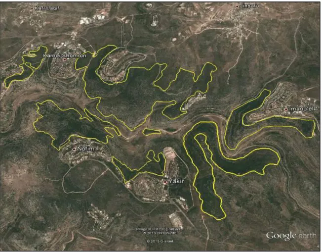
1- Wadi Qana:
Is the Palestinian nature reserve, which lies between Qalqilya and Salfit, but followed Salfit administrative zone in the northern part of West Bank (fig.10), with an estimated area is 9.39 km2 with altitude 500–775 meter and with mean annual rainfall of 676 mm. It surrounded with Palestinian villages; From the northern villages of Jeansafout, Kafir lakef and Azoun, from the west it Surrounded by villages of Sineria and Kafir thoulth, from south it surrounded by village of Krawet Bani Hassan and it surrounded by villages of Deir Istya and Ammatin From East; most of the land owned by farmers from the town of Deir Istya with total area of more than 40.47 Km2
(IWPS; 2005, IWPS; 2013, http://maannews.net).
Wadi Qana located in the geopolitical region “C” so it is under the control of the Israeli authorities, between 1978 and 1986, several settlements were established on the hills overlooking
25
both banks of the wadi: Immanuel and Karnei Shomron to the north; Yaqir and Nofim to the south. Later, the settlement of Karnei Shomron expanded to several nearby hills as well. Between 1998 and 2000, the settlement outposts of Alonei Shilo, El Matan, and Yair Farm were established by these settlements (http://www.btselem.org, IWPS; 2005). Wadi Qana is a fertile valley, where it is one of the tributaries of the Yarkon Rive with seven main natural springs and nine smaller ones, is in Area C and includes several springs (http://www.btselem.org, IWPS; 2005, IWPS; 2013).
Wadi Qana is between two ranges of hills, making it very suitable for citrus plantations. (http://www.btselem.org, IWPS; 2005) but the beauty of the Wadi Qana valley hides rampant pollution that has plagued the village since the surrounding Israeli settlements were built, whereas Wadi Qana is surrounded by nine Israeli settlements, all illegal under international law(fig.11). But the river is black and grey by sewage pours down the hillsides into the valley, some through pipes and some directly onto the landscape. Ironically, this valley has been classified as a nature reserve by the Israeli Authority (IWPS; 2005, IWPS; 2013).
Fig.10: location of Wadi Qana and the settelments around it
In 1983, the Nature Reserves and National Parks Unit of the Civil Administration established the Qana River Reserve, despite the land being privately owned by Palestinians, declaring a nature reserve on an area of roughly0.14 Km2 along the valley floor of Wadi Qana and its surrounding
26
slopes. Paradoxically, the Administration has been issuing orders to farmers to uproot olive trees on this land since 1986 with the explanation that this must happen because it’s a Natural Reserve (http://www.btselem.org).
The natural environment of Wadi Qana is indeed unique and impressive and is worthy of protection, whereas around the year 1999, the trees started dying and water tests proved that more than 70% of the water supply was severely polluted from sewage waste pumped down from the settlements. A few hundred trees died (IWPS; 2013).
Wadi Qana is example of Plantation of the Jordanian Period, around a pre-existing kernel of Natural Plants with mixed natural stand and plantation dominant, the types of soil in this area are
Loessial Serozem, Terra Rossa and brown Rendzina.
The dominant types of palnt species are Pinus halepensis Mill., Quercus infectoria G. Olivier,
Quercus coccifera L., Olea europaea L., Pistacia palaestina Boiss, Pistacia lentiscus L., Rhamnus lycioides L., Cistus creticus (L.), Cistus. salviifolius L., Smilax aspera L, Calicotome villosa (Poir.) Link, Styrax officinalis L., Lonicera etrusca G Santi, Ruta chalapensis L., Sarcopoterium spinosum (L.) Spach, Dittrichia viscosa (L.) Greuter, Ceratonia Siliqua L., Salvia fruticosa Mill., Origanum syriaca L., Thymbra spicata L., Teucrium polium L.
The area is a reservoir of medicinal plants for Salfit and Nablus cities and contains many species protected by law such as Ophrys spp and Tulipa agenesis DC. (DEBPAL 2)
In addition to the pollution from the settlements sewage the valley suffers of wood cutting, over harvesting of medicinal plants, agricultural expansion and road construction, all threaten this IPA (Important Plant Area).
27
Fig.11: the protected area of Wadi Qana
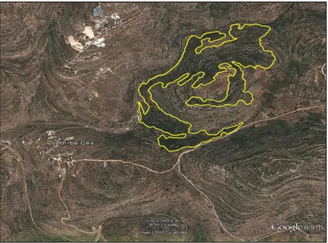
2- Kherbit Qais
:
The village of Khirbet Qais located to the south of the city of Salfit at a distance of 4 km, with an estimated total area is 0.49 km2, Located in area “C” on a hill with altitude 400-490 m. It surrounded by the city of Nablus in the north, the village of Farkha in the northwest, the village of Amouria in the East, the village of Krawat Bani Zaid in the East, the village of Mzare’ Alnobani in the Southwest, the village of Aroura in the south and the village of Abwein in the South East, it surrounded by mountains on all sides (Fig.12) (http://jamilabboud.com).