Studies on the Value of Cultural Heritage
201
9
19
IL CAPITALE CULTURALE
n. 19, 2019
ISSN 2039-2362 (online)
Direttore / Editor
Massimo Montella †
Co-Direttori / Co-Editors
Tommy D. Andersson, Elio Borgonovi, Rosanna Cioffi, Stefano Della Torre, Michela di Macco, Daniele Manacorda, Serge Noiret, Tonino Pencarelli, Angelo R. Pupino, Girolamo Sciullo
Coordinatore editoriale / Editorial Coordinator
Giuseppe Capriotti
Coordinatore tecnico / Managing Coordinator
Pierluigi Feliciati
Comitato editoriale / Editorial Office
Giuseppe Capriotti, Mara Cerquetti, Francesca Coltrinari, Patrizia Dragoni, Pierluigi Feliciati, Valeria Merola, Enrico Nicosia, Francesco Pirani, Mauro Saracco, Emanuela Stortoni, Federico Valacchi
Comitato scientifico - Sezione di beni culturali / Scientific Committee - Division of Cultural Heritage
Giuseppe Capriotti, Mara Cerquetti, Francesca Coltrinari, Patrizia Dragoni, Pierluigi Feliciati, Maria Teresa Gigliozzi, Susanne Adina Meyer, Massimo Montella †, Umberto Moscatelli, Sabina Pavone, Francesco Pirani, Mauro Saracco, Emanuela Stortoni, Federico Valacchi, Carmen Vitale
Comitato scientifico / Scientific Committee
Michela Addis, Tommy D. Andersson, Alberto Mario Banti, Carla Barbati, Sergio Barile, Nadia Barrella, Marisa Borraccini, Rossella Caffo, Ileana Chirassi Colombo, Rosanna Cioffi, Caterina Cirelli, Alan Clarke, Claudine Cohen, Lucia Corrain, Giuseppe Cruciani, Girolamo Cusimano, Fiorella Dallari, Stefano Della Torre, Maria del Mar Gonzalez Chacon, Maurizio De Vita, Michela di Macco, Fabio Donato, Rolando Dondarini, Andrea Emiliani †,
Emanuele Invernizzi, Lutz Klinkhammer, Federico Marazzi, Fabio Mariano, Aldo M. Morace, Raffaella Morselli, Olena Motuzenko, Giuliano Pinto, Marco Pizzo, Edouard Pommier †, Carlo Pongetti, Adriano Prosperi, Angelo R. Pupino, Bernardino Quattrociocchi, Mauro Renna, Orietta Rossi Pinelli, Roberto Sani, Girolamo Sciullo, Mislav Simunic, Simonetta Stopponi, Michele Tamma, Frank Vermeulen, Stefano Vitali
Web
http://riviste.unimc.it/index.php/cap-cult
Editore / Publisher
eum edizioni università di macerata, Centro direzionale, via Carducci 63/a – 62100 Macerata tel (39) 733 258 6081 fax (39) 733 258 6086 http://eum.unimc.it [email protected] Layout editor Roberta Salvucci
Progetto grafico / Graphics
+crocevia / studio grafico Rivista accreditata AIDEA Rivista riconosciuta CUNSTA Rivista riconosciuta SISMED Rivista indicizzata WOS Rivista indicizzata SCOPUS Inclusa in ERIH-PLUS
The management of cultural
heritage and landscape in inner
areas
edited by Mara Cerquetti, Leonardo J.
Sánchez-Mesa Martínez, Carmen Vitale
stendono a prendere il sole. Li osservo e mi sforzo di comprendere. Nessuno può capire cosa c’è sotto le cose. Non c’è tempo per fermarsi a dolersi di quello che è stato quando non c’eravamo. Andare avanti, come diceva Ma’, è l’unica direzione concessa. Altrimenti Dio ci avrebbe messo gli occhi di lato. Come i pesci1.
Quando cammino nei prati attorno al Santuario, quasi sempre solo, ripenso a nonno Venanzio che, da giovane biscino, pascolava il gregge negli stessi terreni. Mi affascina il fatto che in questo luogo la cui cifra, agli occhi di chi guarda adesso la mia scelta di vita, è la solitudine, nei secoli addietro abitassero oltre duecento persone. Ancora negli anni Cinquanta, ricorda mio nonno, erano quasi un centinaio gli abitanti di Casette di Macereto tra contadini, mezzadri, mogli, pastori e un nugolo di bambini che costringeva il maestro a salire ogni giorno da Visso per fare lezione a domicilio.
Era una comunità compatta, coordinata come lo può essere quella delle società operose degli insetti: api, formiche, tremiti, ma cosa più sorprendente che mai, una comunità niente affatto statica o chiusa2.
1 Balzano M. (2018), Resto qui, Torino: Einaudi, p. 175.
Moscarelli R., Slow tourism infrastructure to enhance the value of cultural heritage in inner areas «Il capitale culturale», n. 19, 2019, pp. 237-254
ISSN 2039-2362 (online); DOI: 10.13138/2039-2362/1957
Slow tourism infrastructure to
enhance the value of cultural
heritage in inner areas
* Rossella Moscarelli, Phd student, Politecnico di Milano, Department of Architecture and Urban Studies, Via Edoardo Bonardi, 3, 20133 Milano, e-mail: [email protected]. The author is grateful to the research group VENTO, Politecnico di Milano, Department of Architecture and Urban Studies, for the use of the trace of the cycle path and for the support in the developing of the article.
Rossella Moscarelli
*Abstract
The paper investigates whether the value of cultural heritage can be enhanced through what we have termed “slow tourism infrastructure”, connecting individual assets in a regional network. It examines the context of Italian inner areas, where phenomena of marginalisation risk leaving a vast amount of heritage in a state of abandonment. Slow tourism infrastructure, such as long-distance cycle and walking paths, can be considered threads which connect local areas and regenerate heritage dispersed throughout the territory. The main aim of this study is to contribute to the regeneration of the inner areas thanks to the potential of what has been called their “territorial capital” which consists of the natural, cultural and human capital that characterises different regions. Slow tourism infrastructure makes it possible to experience this capital in an alternative way by connecting the area through which it passes in a linear fashion. The paper analyses the relationship between cultural heritage in inner areas and slow infrastructure routes by examining the VENTO project, a cycle path stretching 679 kilometres from Venice to Turin along the Po River,
and describes how such a project can potentially reconnect and regenerate cultural heritage spread throughout the Po Valley.
Il paper indaga come le infrastrutture turistiche lente (ciclovie o cammini di lunga distanza), possano essere considerate linee di fruizione del patrimonio culturale, naturale e umano dei luoghi che attraversano. Queste infatti lungo il loro percorso possono ricucire i singoli beni, oggi isolati e slegati tra loro, inserendoli in un nuovo racconto unitario e di sistema. Il potenziale rigenerativo di tali infrastrutture è ancora più rilevante se si considera il contesto delle aree interne italiane, dove gravi processi di marginalizzazione mettono a rischio anche il patrimonio territoriale: come le aree interne si spopolano, così anche i loro patrimoni vengono abbandonati e dimenticati. Le infrastrutture turistiche lente possono diventare una strategia di sviluppo per le aree interne del Paese e del loro patrimonio poiché permettono di scoprire e vivere il capitale territoriale, ovvero le risorse naturali, culturali e umane, peculiari di ciascun luogo. L’inedita relazione tra patrimonio culturale, aree interne e infrastrutture turistiche lente viene analizzata attraverso un caso studio, la dorsale cicloturistica VENTO. VENTO è il progetto di una ciclovia di 679 km, da Venezia a Torino, lungo il fiume Po. Verrà approfondito come il patrimonio territoriale della valle del Po può essere ricucito e rigenerato grazie al filo ciclabile di VENTO.
1
.
Depopulation: a risk for cultural heritageGrowing interest in marginalisation of inner areas is highlighted by recent European and Italian policies and by active international debate. In Italy, marginalised inner areas were once again brought into focus1 in 2014 by the National Strategy for Inner Areas (Strategia Nazionale Aree Interne)2, which
defines inner areas as municipalities located a certain distance3 from major
centres those providing three essential services (education, health and mobility). The classification takes into account these three essential services since they are important markers of citizens’ quality of life and level of social inclusion. Therefore, the country is divided into municipalities providing services (centres) and municipalities lacking such services which are marginalised as a result (inner areas). The current condition of inner areas is well described by another term used to identify them in Europe, that is “shrinking areas”4. Indeed,
depopulation trends in these areas highlight the alarming condition in which they find themselves. Firstly, populations fall below the critical threshold and exhibit demographic ageing, leading to dwindling employment. Secondly, these
1 Since the 1950s, several national policies have been implemented in Italy to stem the decline
of marginalised areas, such as southern regions, or mountain and rural areas. These strategies tried to help less favoured areas with subsidies and specific funds.
2 UVAL 2014.
3 The UVAL classification measures remoteness from services in terms of minutes necessary to
reach them. Municipalities over twenty minutes from services are regarded as inner areas.
239
areas have witnessed the progressive quantitative and qualitative decline in local public, private and community services. This demographic crisis naturally exacerbates the risk of losing natural and historical heritage5. The vast capital
still present in inner areas must be maintained by human activities and presence. According to Rossi-Doria, who introduced the term “inner area” to describe rural areas in the South of Italy, regarding them as the “bones” as opposed to the “flesh”, the critical issue of these “bone” areas was the imbalance between population and resources. He wrote:
attraverso i decenni […] si è così consolidata nella montagna meridionale una povera società di uguali, prevalentemente di piccoli proprietari, il cui precario equilibrio per cinquant’anni, dopo il 1880, si è retto grazie all’emigrazione, che non solo ha permesso di mantenere in qualche modo fermo il rapporto tra popolazione e risorse, ma ha consentito di integrare i modestissimi redditi agricoli e di accrescere sia pur di poco il tenore di vita. Il vero dramma di queste zone si ebbe quando, dopo il 1921, l’emigrazione si interruppe e la crescente popolazione fu costretta a vivere più densa delle sole risorse locali6.
Since the agricultural system was unable to provide the necessary resources and incomes, the population of those areas could no longer live there. In other words, the population exceeded the carrying capacity of the system. Nowadays, something different is happening. The depopulation of inner areas has led to the risk of abandonment of the resources themselves.
2
.
Imagining a regeneration projectThe process of decline and shrinkage of remote areas is widespread in both Italy7 and Europe8; indeed, a European report on the issue of marginalised
areas, the so-called “inner peripheries”9, has recently been published. As the
report highlights, regions are peripheral not only because of their geographical remoteness (as in the Italian classification), but also because of their lack or low
5 Di Biase 2013.
6 «Over the decades […] in the southern mountains a poor society of peers, mainly small
landowners, has become established, the precarious equilibrium of which held firm for fifty years starting from 1880 thanks to emigration, which not only made it possible to maintain to some degree the relationship between population and resources but also allowed extremely modest incomes from farming to be supplemented and increase – albeit by little – the standard of living. The true drama of these zones came about when, after 1921, emigration ceased and the growing population was forced to live more densely than the local resources alone» (Rossi-Doria 2003, pp. 74-75, own translation).
7 Sixty per cent of Italy’s land area accounts for just 13.5 million (approximately 22%) of its
population (UVAL 2014).
8 ESPON 2017b; Nordregio 2014. 9 ESPON 2017b.
level of proximity to the main social, political and economic activities10. This
means that the original spatial meaning of the term “peripherality”, associated with the economic and social costs inherent in living at a distance from major centres, has taken on a range of analogous meanings, which are to do with socio-economic marginality in a non-spatial sense11. The concept of so-called
“organised proximity”12, which is the level of social, legal and institutional
connection, may be relevant in this regard. Thus, according to Bock:
whereas in the past, the main cause [of uneven development] was ascribed to geography, this has changed in the sense that the lack of resources is now explained as resulting from a lack of socioeconomic and political connections (“connectivity”) and, hence of relational “remoteness” that is not necessarily bounded to geographical location […]. Geographical remoteness, as such, therefore does not cause marginalization, nor does central location promise prosperity13.
There is an active debate on the possibility of revitalising marginalised areas. It is interesting to note that the idea of peripherality itself has led to multiple hypotheses for regeneration. Indeed, if peripheries are «linked to disconnectedness and thus marginalization from the main (“standard”) developments by their inconvenient position»14, they are simply seen as “laggards” which need to be
pushed to resemble core areas. Therefore, strategies that are usually effective in core areas are being applied to inner areas too. In contrast, if peripheral areas are considered in terms of their peculiarities, it is possible to foster specific strategies for them which differ from the models developed in other contexts.
These peculiarities, that is to say the unique resources possessed by each place, may represent the so-called “territorial capital”. Territorial capital was first defined by the OECD in 2001 as «the stock of assets which form the basis for endogenous development in each city and region, as well as […] the institutions, modes of decision-making and professional skills to make best use of those assets»15. Territorial capital in Italy’s inner areas consists of:
(1) environmental capital (water resources, agricultural systems, forests); (2) cultural capital (archaeological assets, historical settlements, churches and abbeys, museums); and (3) cognitive/human capital (landscape, craftsmanship, know-how in traditional activities and productions, local foods, habits and dialects, social energy of the local population)16.
10 Copus et al. 2017. 11 Copus 2001.
12 Torre, Rallet 2005; Boschma 2005. 13 Bock 2016, p. 5.
14 Makarychev 2004, p. 300. 15 OECD 2001, p. 13. 16 UVAL 2014.
241
Starting from this definition, placing value on territorial capital becomes the main strategy to activate an alternative model of development, with a consequent regeneration for inner areas17.
3. Is slow tourism infrastructure a way to enhance territorial capital? One such innovative way to exploit territorial capital, can be found in the increasing focus on the so-called “experience economy”18 as a way of reactivating
more isolated areas19. In this economic model, what is most significant is the
experience of the resources of a place, such as its cultural heritage, natural environment, local traditions or traditional know-how. In other words, what matters is the place itself. In the experience economy, place is integrated within the product as a narrative, and it can be consumed as a distinctive experience connected to the service. In this sense, geographical and cultural distance, otherwise seen as a barrier for development, can even be turned into attractions.
Firstly, from the cultural perspective, developing infrastructure that promotes slow tourism experiences, such as cycling or walking paths, can therefore represent key ways of revitalising inner areas. Walking and cycling can be seen as “triggers” for entering such areas and enjoying experiences based on their unique resources. Slow tourism infrastructure can provide the thread that reconnects their beauties. Moving slowly and continuously between different landscapes allows them to become narrative and representative places in movement20.
Seen from a cultural perspective, slow tourism infrastructure is not designed for “athletes”, but is inclusive in that it provides something enjoyable for everyone. It allows places to be visited in an unusual way, where the points of departure and arrival are far less important than the journey itself. Such infrastructure can reconnect the different elements of territorial capital through which it passes; this provides them with continuity and establishes them within a network. Moreover, the challenge in regenerating such cultural heritage may be that of reclaiming the “meaning” that risks being lost. It is imperative to connect such heritage with the area in which it is located in order to re-establish its voice and identity. If, as the anthropologist Marc Augé21 notes, contemporary
cities are to become “planetarium places”, in which citizens do not recognise themselves, cities for everyone but no one at the same time, it becomes even more important to prevent the loss of this cultural heritage that represents the identity bond connecting citizens and territory. From this perspective, inner
17 Fratesi, Perucca 2017; Mazzola et al. 2018; Romão, Neuts 2017. 18 Toffler 1970; Scott 1997, 2006.
19 Lorentzen 2012. 20 Pileri et al. 2015. 21 Augé 2017.
areas are valuable and strategic national assets since they can be considered “territorial heritage”22: a complex system of ecological, cultural, symbolic and
economic potential which urban policies should valorise not only as capital to be exploited but also as an identity-giving resource for the whole community.
Secondly, from the economic perspective, unemployment (as already mentioned briefly above) is one of the main problems affecting inner areas, which require an alternative model of development. Slow tourism can bring economic benefits and new kinds of employment. Well-designed networks of slow tourism infrastructure23 can generate demand for services related to: (1)
the consumption of local food or craft products; (2) accommodation (hotels, bed and breakfast establishments, etc.); (3) enjoyment of places (museums, cultural experiences, etc.); and (4) specific services (equipment repairs, technical apparel, etc.). Slow tourism can, therefore, create employment, particularly in inner areas, with their unique territorial capital. Well suited to existing networks of micro-enterprises, it can serve as an alternative response to the crisis of ideas that has stunted employment generation. Just taking into account one kind of such slow tourism, bicycle touring, it is possible to demonstrate the positive economic effect generated. Each kilometre of cycle path in Europe has created and maintains between 4 and 5 jobs24. In Germany, where bicycle touring
generates 3.9 billion euros of revenue per year, it has been calculated that half of what cyclists spend is on accommodation and food, thus contributing to local economies. In that country, on average, cyclists on bicycle holidays spend 64 euros per day as against 16 euros per day spent by cyclists on day trips25.
Third, from the administrative perspective, it should be remembered that one of the main issues affecting inner areas is their condition of isolation, which is exacerbated by administrative fragmentation26 resulting from the high number
of small municipalities, both in Italy and in Europe27. It is thus necessary to
develop and implement strategies that foster communication and cooperation
22 Poli 2015.
23 Slow tourism routes have to be long (at least 150 kilometres) to “generate” one overnight
stay. Furthermore, they have to have dedicated, safe, continuous facilities. This is important as it makes slow travel experiences accessible to and enjoyable for as many people as possible (adults and children, experts and beginners, etc.). Another significant feature is the capacity to interconnect with other infrastructure, both slow and fast, such as railways, roads, etc., in order to multiply travel options.
24 Unlocking new opportunities 2014. 25 ADFC 2017.
26 Regarding the issue of administrative fragmentation, De Matteis points out that
fragmentation is a critical problem in Italian urban policy, as it is characterised by vertical and horizontal barriers. Vertical barriers have to do with the difficulty that bodies responsible for urban policy at different levels of government have in coordinating their policies (e.g. municipalities, especially the smallest, with regional and national agencies), whereas horizontal barriers are related to the lack of cooperation between administrations at the same level of government. See De Matteis 2013.
243
between different administrative units (municipalities, districts or regions). Territorial projects, promoted by slow tourism routes, are a useful way of re-establishing the connections that emphasise the unique overall identity of each marginalised territory.
In Italy, examples of agents for such regeneration processes include Ferrovie dello Stato (the national railway company) or other national bodies with underused heritage spread throughout the country. Examples of potential actions recently promoted by such bodies include the reports published by RFI (Rete Ferroviaria Italiana)28 in 2017, Atlante di viaggio lungo le ferrovie dismesse,
and in 2016, Atlante delle line ferroviarie dismesse, and by the Agenzia del Demanio29 (the agency responsible for Italy’s public property), Valore Paese – Cammini e Percorsi, in 2017, on Italy’s main tourism and cycle pathways.
The aim in both cases is to regenerate underused heritage. Both actors can play a significant role in developing slow tourism infrastructure networks (the former with its unused railway line and the latter which owns a large amount of tourism assets).
4. VENTO: a case study
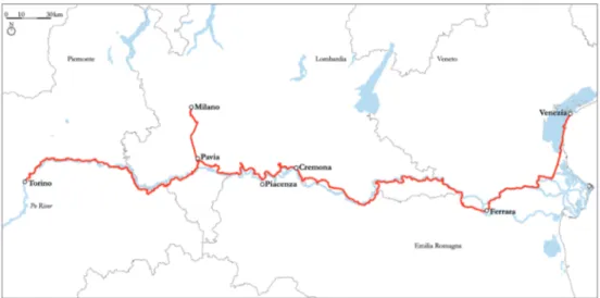
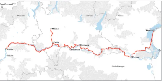
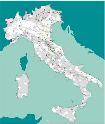
The project described below is a potential example of how territorial capital in marginalised areas could be revitalised by slow tourism routes. VENTO is a cycle route of 679 kilometres which runs along the Po River, between Venice and Turin via Milan30 (fig. 1).
The project for this prospective cycle route was originally developed by a research group at the Politecnico di Milano31. In 2016, it was included in the Italian National Cycle Network, Ciclovie Turistiche Nazionali (fig. 2), from which funding was received for the initial design phase.
The VENTO route crosses 21 municipalities classified as inner areas (fig. 3) according to the UVAL classification, in other words 15% of the 121 municipalities through which it passes, although it should be pointed out that many of the other 100 municipalities not officially classified as inner areas are also characterised by a condition of marginalisation.
This study presents the territorial capital that VENTO could potentially help to regenerate. Indeed, the analysis focuses on how the VENTO cycle route can connect and place value on different categories of territorial capital: (1)
28 <www.rfi.it>, 30.05.2018.
29 <www.agenziademanio.it>, 30.05.2018.
30 In this paper we are referring to the first version of the VENTO project, whose length was of
679 kilometers. Actually, the cycle path was redesigned and now its length is about 700 kilometers.
environmental capital, such as rivers, protected parks and natural sites; (2) cultural capital, such as museums, historical sites, etc.; and (3) human capital, such as traditional food, know-how, etc. The latter category is as important as the first two, although it is more difficult to map.
4.1 VENTO and environmental capital
The VENTO cycle route runs along the Po River, Italy’s longest and most important river. This fact in itself provides an opportunity to place value once again on this significant environmental asset. The Po River no longer serves its historical functions such as the transportation of goods or navigation. It is crossed by high-speed train and motorway bridges. A major cycle route would allow the river to be perceived as a landscape continuum once again, from the Alps to the sea, and a way to rediscover the region in its entirety. Moreover, it is interesting to consider the fact that between Turin and Venice the VENTO cycle route encounters all of the River Po’s 37 tributaries (fig. 4).
These tributaries are important as they offer the chance to create other cycle routes, thus creating a cycle network that allows tourists to experience the whole region.
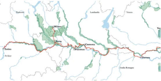
Most of the main protected areas are related to these tributaries, along which several Regional Parks have been created. In total, 264 kilometres, or 40%, of the VENTO cycle route, cross protected areas. VENTO crosses more than 40 regional parks, Sites of Community Importance (SIC), Special Protected Zones (ZPS), wetlands, a WWF protected area and two LIPU (Italian Society for the Protection of Birds) sanctuaries (fig. 5).
Many of these areas are home to an extraordinary variety of nature species and a wealth of precious biodiversity. But if we look at them from afar, we quickly realise that they are neither as one along the Po nor linked together. They appear as a series of green islands, fragmented in terms of pattern and management.
4.2 VENTO and cultural capital
«VENTO is like a necklace whose beads are the many cultural attractions scattered across the Po territories»32.
All along the VENTO cycle route, within five kilometres of the main cycle path, lie hundreds of cultural attractions such as historical towns and buildings, museums, churches and abbeys33, in addition to a large number of farm
32 Pileri et al. 2015, p. 134. 33 Bonacina 2014.
245
buildings, land reclamation architecture and many other artefacts which go unnoticed because they are excluded from traditional channels of promotion. With VENTO, such heritage can come together in a new “narrative thread”.
In order to assess the cycle route’s potential, the cultural assets located directly along the VENTO route were quantified34. A total of 60 cultural
assets are located directly along the path: 21 places of worship (fig. 6), 12 historical buildings (fig. 7), 6 museums and 21 buildings related to the historical reclamation of the Po valley (fig. 8).
4.3VENTO and human capital
Mapping human capital is more difficult than the other resources evidenced above. Indeed, human capital incorporates intangible assets, such as knowledge and know-how. Local foods, with their agricultural tradition, represent a good example of this kind of capital. Along the VENTO cycle route there is a great deal of local produce, much of which has obtained DOC, IGP and DOP status. Moreover, it is interesting to highlight that landscape and food are closely connected: as the landscape slowly changes, so does the food that it produces.
UNESCO sites are good markers of how rich places are in human capital, as they consider both tangible values (historical and natural), and intangible values (human capital). Moreover, they are often not precisely delimited sites but instead extend across several municipalities which exhibit comparable features worthy of safeguarding and promotion. Ten UNESCO sites featuring tangible or intangible heritage are located along or near the VENTO cycle route (fig. 9). They are: Sabaudia residences in Turin, the Po and Torinese hill park in the area of Turin, the wine-producing landscape of the Langhe-Roero and Monferrato areas near Alessandria, the Ticino river valley, the church and monastery of Santa Maria delle Grazie and the Cenacolo (Last Supper) by Leonardo da Vinci in Milan, the luthier tradition in Cremona, the cities of Mantua and Sabbioneta, the city of Ferrara, the park of the Po Delta and the city of Venice.
5. Conclusions
Italian inner areas can be considered marginalised territories, a far cry from the main “hubs” that provide essential services. They are experiencing a demographic crisis, which risks leaving their vast heritage in a state of abandonment. To stem this decline, it is possible to start from existing resources,
34 These cultural assets were mapped using several surveys carried out along the VENTO cycle
that is, their territorial capital. Slow tourism routes offer an innovative way of placing value on the territorial capital that they contain as they can connect all types of heritage (natural, cultural and human) in a network. The relatively sedate pace of travel enables tourists to discover places and enjoy experiencing their peculiar characteristic. Considering individual resources as part of a unique regional project means on the one hand valorising the asset and on the other the possibility to develop a narrative project along the infrastructure item.
The VENTO case study shows the potential of slow tourism routes to reconnect various heritage assets, be they natural or cultural, tangible or intangible, or in a precisely or at territorial scale. It is necessary to contextualise such case study in the complex Italian reality. Indeed, the case of VENTO is peculiar, firstly for topographical reasons: its location in the Po Valley plain and consequent flatness makes it easier to imagine long-distance bicycle touring infrastructure that can be enjoyed by anyone. Italy in contrast is a largely, hilly mountainous country where it is not always possible to design long, continuous cycle routes of the kind that exist in Germany or the Netherlands. Indeed, in Italy the potential for walking paths as well as cycle paths needs to be considered. Following the establishment of the Italian National Cycle Network in 2016, a Digital Atlas of Italian Paths, Atlante dei Cammini d’Italia, was created (fig. 10), which shows how these historical traces of movement that have been recovered as slow tourism routes are largely concentrated in the Apennine areas.
It is even more interesting to overlap the map of the inner areas (fig. 11), which highlights how these pathways intersect the inner areas or “bones” of the country, as explained above.
If the same analysis presented in this paper for the VENTO case study was extended to these routes, the results would be extraordinary: these lines would reconnect hundreds of cultural, environmental and human assets. And this would happen in the most fragile areas of the country, that is, in those inner areas that can be regenerated starting from their own territorial capital.
Finally, this analysis sets out three key elements: slow tourism routes, inner areas and territorial capital. The problem is that policies to foster each of these elements are not coordinated and they are unable to create a single vision. On the one hand, there are signs of growing interest in these issues, such as the development of a strategy for inner areas and the atlases of foot and cycle paths. On the other hand, these actions need to be integrated within a single strategy where the idea of slow tourism is closely related to the territory through which it passes. Only thus will it be possible to make the slow tourism routes a true opportunity for local economic, social and cultural regeneration.
247
References / Riferimenti bibliografici
ADFC (2017), Travelbike Bicycle Travel Analysis, <https://www.adfc. de/fileadmin/user_upload/Expertenbereich/Touristik_und_Hotellerie/ Radreiseanalyse/Downloads/ADFC_Bicycle_Travel_Analysis__2017__ engl._fact_sheet_.pdf>, 14.03.2019.
Augè M. (2017), Un altro mondo è possibile, Torino: Codice Edizioni.
Bonacina E. (2014), Paesaggio e infrastruttura cicloturistica: la costruzione
di un rapporto biunivoco. Il caso del progetto VENTO, master thesis,
Politecnico di Milano.
Borghi E. (2017), Piccole Italie. Le aree interne e la questione territoriale, Roma: Donzelli editore.
De Matteis G. (2013), Preface, in Governare il consumo di Suolo, edited by M. Giudice, F. Minucci, Firenze: Alinea Editrice, pp. I-XI.
Di Biase C. (2013), Small towns in inland areas: shared landscapes, in
Conservation – Reconstruction. Small historic centers conservation in the midst of change, edited by R. Crisan, D. Fiorani, L. Kealy, S.F. Musso, Hasselt:
EAAE – European Association for Architectural education, pp. 131-139. Bock B. (2016), Rural Marginalisation and the role of Social Innovation: a
turn towards nexogenous development and rural reconnection, «Sociologica
Ruralis», 56, n. 4, pp. 552-573, <https://doi.org/10.1111/soru.12119>, 14.03.2019.
Boschma R.A. (2005), Proximity and innovation: a critical assessment, «Regional Studies», 39, n. 1, pp. 61-74, <https://doi.org/10.1080/00343400 52000320887>, 14.03.2019.
Copus A. (2001), From Core-Periphery to Polycentric Development. Concept
of Spatial and Aspatial Peripherality, «European Planning Studies», 9, n. 4,
pp. 539-552, <https://doi.org/10.1080/713666491>, 14.03.2019.
Copus A., Mantino F., Noguera J. (2017), Inner Peripheries: an oxymoron
on real challenge for territorial cohesion?, «Italian Journal of Planning
Practice», VII, n. 1, pp. 24-49.
Danson M., de Souza P., edited by (2012), Regional development in Northern
Europe: peripherality, marginality and border issues, London: Routledge.
ESPON (2017a), Policy Brief: Shrinking rural regions in Europe, <https:// https://www.espon.eu/rural-shrinking>, 14.03.2019.
ESPON (2017b), PROFECY – Inner Peripheries: National territories facing
challenges of access to basic services of general interest, <https://www.espon.
eu/inner-peripheries>, 14.03.2019.
Fratesi U., Perucca G. (2017), Territorial capital and the resilience of European
regions, «The Annals of Regional Science», 60, n. 2, pp. 241-264, <https://
doi: 10.1007/s00168-017-0828-3>, 14.03.2019.
Herrschel T. (2012), Regionalisation and marginalization: bridging old and
Lorentzen A. (2012), The development of the periphery in the experience
economy, in in Danson, de Souza 2012, pp. 16-29.
Makarychev A. (2004), Where the North meets the East: Europe’s
“dimensionalism” and Poland “marginality strategy”, «Cooperation and
Conflict: Journal of the Nordic International Studies Association», 39, n. 3, pp. 299-315, <https://doi.org/10.1177/0010836704045206>, 14.03.2019. Mazzola F., Lo Cascio I., Epifanio R., Di Giacomo R. (2018), Territorial capital
and growth over the Great Recession: a local analysis for Italy, «The Annals
of Regional Science», 60, n. 2, pp. 411-441, <https://doi.org/10.1007/ s00168-017-0853-2>, 14.03.2019.
Nordregio (2004), Mountain Areas in Europe: Analysis of mountain areas in
EU member states, acceding and other European countries, Nordic center
for spatial development, <http://archive.nordregio.se/en/Publications/ Publications-2004/Mountain-areas-in-Europe/index.html>, 14.03.2019. OECD (2001), OECD territorial outlook, Paris: OECD – Organisation for
Economic Co-operation and Development.
Pileri P., Giacomel A., Giudici D. (2015), VENTO. The gentle revolution cycling
its way through the landscape, Mantova: Corraini Edizioni.
Poli D. (2015), Il patrimonio territoriale fra capitale e risorsa nei processi di
patrimonializzazione proattiva, in Aree interne e progetti d’area, edited by
B. Meloni, Torino: Rosenberg&Sellier, pp. 123-140.
Romão J., Neuts B. (2017), Territorial capital, smart tourism specialization
and sustainable regional development: Experiences from Europe,
«Habitat International», n. 68, pp. 64-74, <https:// doi.org/10.1016/j. habitatint.2017.04.006>, 14.03.2019.
Rossi-Doria M. (2004), Dieci anni di politica agraria nel Mezzogiorno [1958], Napoli: L’ancora del Mediterraneo.
Rossi-Doria M. (2003), Scritti sul Mezzogiorno [1982], Napoli: L’ancora del Mediterraneo.
Scott A.J. (1997), The cultural economy of cities, «International Journal of Urban and regional Research», 21, n. 2, pp. 323-339, <https://doi. org/10.1111/1468-2427.00075>, 14.03.2019.
Scott A.J. (2006), Creative cities: conceptual issues and policy questions, «Journal of Urban Affairs», 28, n. 1, pp. 1-17.
Toffler A. (1970), Future Shock, New York: Bantam books.
Torre A., Rallet A. (2005), Proximity and localization, «Regional Studies», 39, n. 1, pp. 47-59, <https:// doi.org/10.1080/0034340052000320842>, 14.03.2019.
Unlocking new opportunities. Jobs in green and healthy transport (2014), World
Health Organization, <https://thepep.unece.org/sites/default/files/2017-05/ Unlocking-new-opportunities-jobs-in-green-and-health-transport-Eng.pdf>, 14.03.2019.
UVAL (2014), A strategy for Inner Areas in Italy: definition, objectives, tools
and governance, Public Investment Evaluation Unit, <http://old2018.
249
Appendix
Fig. 2. The VENTO cycle route included in the Italian National Cycle Network (Source: Ministero delle Infrastrutture e dei Trasporti, <www.mit.gov.it>, 30.05.2018)
Fig. 3. The VENTO cycle route (in red) and municipalities regarded as inner areas (in grey)
251
Fig. 5. The VENTO cycle route (in red) and protected areas (in green)
Fig. 6. The church of Santa Maria all’Argine, along the VENTO cycle route in the municipality of Casalmaggiore, close to Cremona (© photo by Alessandro Giacomel)
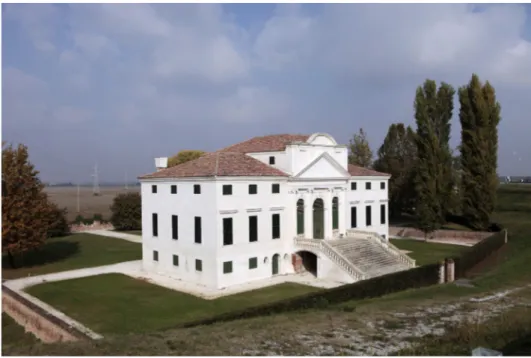
Fig. 7. The historical Villa Morosini, along the VENTO cycle route in the municipality of Polesella, close to Rovigo (© photo by Alessandro Giacomel)
Fig. 8. Amajestic drainage pump, along the VENTO cycle route in the municipality of Sermide, close to Mantova (© photo by Alessandro Giacomel)
253
Fig. 9. The VENTO cycle route (in red) and nearby UNESCO sites (red bubbles)
Fig. 10. Image from the Digital Atlas of Italian Paths. The website contains an interactive map of Italian paths, with information and main characteristics (Source: Ministero dei Beni e delle Attività culturali, <www.turismo.beniculturali.it/cammini/>, 30.05.2018).
Fig. 11. Overlapping between the map of the inner areas (in grey) (UVAL 2014) and the Digital Atlas of Italian Paths
eum edizioni università di macerata
JOURNAL OF THE SECTION OF CULTURAL HERITAGE
Department of Education, Cultural Heritage and Tourism
University of Macerata
Direttore / Editor
Massimo Montella †
Co-Direttori / Co-Editors
Tommy D. Andersson, University of Gothenburg, Svezia Elio Borgonovi, Università Bocconi di Milano
Rosanna Cioffi, Seconda Università di Napoli Stefano Della Torre, Politecnico di Milano
Michela di Macco, Università di Roma “La Sapienza” Daniele Manacorda, Università degli Studi di Roma Tre Serge Noiret, European University Institute
Tonino Pencarelli, Università di Urbino "Carlo Bo"
Angelo R. Pupino, Università degli Studi di Napoli L'Orientale Girolamo Sciullo, Università di Bologna
Texts by
Gabriele Ajò, Letizia Bindi, Massimiliano Biondi, Clinton Jacob Buhler, Flaminia Cabras, Chiara Capponi,Michele Catinari, Giacomo Cavuta, Chiara Cerioni, Mara Cerquetti, Paolo Clini, Annalisa Colecchia, Federico, Lattanzio, Manuel De Luca, Sara Manali, Dante Di Matteo, Anna Rosa Melecrinis, Emanuele Frontoni, Letizia Gaeta, Maria Teresa Gigliozzi, Gianpasquale Greco, Elena Montanari, Rossella Moscarelli, CaterinaPaparello, Giulia Pappani, Michela Passini, Roberto Pierdicca,
Mariapaola Puggioni, Ramona Quattrini, Manlio Rossi-Doria,
Leonardo J. Sánchez-Mesa Martínez, Federica Maria Chiara Santagati, Andrea Ugolini, Carmen Vitale