Università Politecnica delle Marche
Facoltà di Scienze
Dottorato di Ricerca in Protezione Civile e Ambientale
XIV Ciclo
Biogenic habitat distribution and effect on coastal
erosion phenomena relating to coastal peculiarities
Tesi di dottorato di: Tutor:
Ubaldo Pantaleo
Prof.ssa Stefania Puce
Co-Tutors :
Prof. Giovanni Besio
Prof. Carlo Cerrano
1
INDEX
ABSTRACT 3
1 INTRODUCTION 5
1.1 Climate change 6
1.2 Coastal intense natural events and tsunami 11
1.3 Vulnerability to coastal hazards 15
1.4 The role of ecosystems in coastal protection 18
1.5 Coastal hydrodynamic modelling 21
1.6 ICZM Protocol, Action Plan in Mediterranean Sea and Disaster Risk
Reduction initiatives in Europe 23
1.7 Aims and structure of the thesis 25
2 CORALLIGENOUS ASSEMBLAGES: BACKGROUND 28
3 COASTAL HYDRODYNAMICS AND PROCESS-BASED NUMERICAL
MODELLING: THE BASICS 35
3.1 Wave propagation: hypotheses and parameters 36
3.2 Wave energy 38
3.2.1 Energy processes 39
3.2.1.1 Shoaling 39
3.2.1.2 Wave refraction-diffraction 41
3.2.1.3 The wave breaking 43
3.2.1.3.1 Iribarren number 44
3.2.1.4 Bottom friction 46
3.2.2 Statistical analysis and Rayleigh distribution 47
3.3 Parametric wave transformation models 49
3.3.1 Equation of the conservation of wave energy 49
3.3.2 WEPM model 51
3.3.3 Runge-Kutta iterative method 51
4 MATERIALS AND METHODS 54
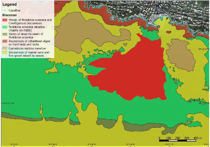
4.1 Study areas and environmental setting 54
4.1.1 Bogliasco – Genoa coastal tract 57
4.1.2 Porto Cesareo – Lecce coastal tract 59
4.2 Wave regime and marine climate 61
4.2.1 Ligurian Sea and Bogliasco area 63
4.2.2 Ionian Sea and Porto Cesareo area 65
4.3 Estimation of seabed physical roughness 66
4.3.1 Sampling strategies and data collection 69
4.3.2 Three-dimensional model generation 73
4.3.3 Benthic coverage and taxa abundance 74
4.3.4 Seabed roughness estimation 75
4.3.5 Statistical analysis 80
4.3.6 Relationship between physical and hydraulic roughness 80
4.4 Process-based numerical model 81
4.4.1 Wave attenuation due to bottom friction 84
4.4.2 Wave attenuation due to each habitat 84
2
5 RESULTS 87
5.1 Three-dimensional digital models of the seabed 87
5.2 Benthic coverage and taxa abundance 89
5.3 Seabed roughness estimation and comparison of different roughness measures 90
5.4 Relationship between physical and hydraulic roughness for hard beds 93
5.5 Process-based numerical models 94
5.5.1 Wave attenuation due to bottom friction 94
5.5.2 Wave attenuation due to each habitat 100
5.5.3 Wave run-up and in land flooding 104
6 DISCUSSIONS 107
6.1 Reconstruction of seabed morphology by using photogrammetry-based Structure
from Motion techniques 108
6.2 Effect of slope on roughness estimation 110
6.3 Roughness as seabed structural complexity measure 110
6.4 Relationship with equivalent hydraulic roughness 113
6.5 Process-based numerical models and run-up calculation 114
7 CONCLUSIONS 116
8 ACKNOWLEDGEMENTS 118
3
ABSTRACT
Structural complexity of underwater environments is closely correlated to biodiversity. Especially in the coastal zone the seabed is characterized by elements able to increase the terrain rugosity such as boulders and other abiotic features, artificial structures and sessile living organisms. With increasing of seabed complexity the interaction between environment and the organisms that inhabit increases as well. The consequence is an increase of biodiversity with increasing of complex elements that characterize the seascape.
Concurrently seascape complexity and roughness may also have influence on abiotic factors characterizing the underwater environment such as sediment transport, wave energy dissipation, flow resistance, light irradiance and so on. Thus the presence of highly rough features in coastal areas and in relatively shallow waters can have important effect on the hydrodynamics and sedimentary process.
To date the importance of several coastal ecosystems is largely recognized not only for economic, aesthetic and recreational values but also for their contribution in increasing biodiversity and in coastal protection. In particular biogenic habitats, here defined as natural features built by living organisms, are able to change the original environment via their own physical structure increasing the seabed complexity and leading to an increase of soil elevation. Until now most of the research work concerning these structures has been focused on the ecological role or targeted to the taxonomic study of the characteristic and associated species and to the study of intra- inter-specific relationships. Abiotic and physical processes (e.g. sediment dynamics and hydrodynamics) were rarely included in the past research works. The accurate definition of the complexity and roughness and the quantification of structural metrics are crucial to fully understand both the relationships between environment and biota, and the effects of different structures (natural or artificial) on wave propagation, currents and sedimentological aspects in coastal zone. Also there is a huge gap between studies carried out in tropical and subtropical environments and temperate ones focused on wave attenuation and coastal protection functions provided by biogenic habitats.
4
Here, using data gathered at two locations in two different Italian regions, we document the changes in wave propagation energy toward the coast due to dissipation effect generated by several habitats with different complexity and roughness. Results of this study confirm the importance of biogenic habitats in wave attenuation and demonstrate the coastal protection function of the coralligenous bank type. Moreover, for the first time the contribution provided by the coralligenous to wave dissipation is estimated on seabed with different slope characteristics.
5
1
INTRODUCTION
The effect of climate change are already being felt, especially in many coastal areas (Spalding et al., 2014) where sea level rise, increase of natural extreme events and different human activities take great importance raising the vulnerability of coastal communities and structures.
The modern age has created profound changes in environmental ethics since the humankind, escaping from the control of natural cycles, began to impose their own needs to nature. These changes occur both locally and globally, for natural or anthropogenic reasons. Scientific and technical progress have only intensified these changes and accelerated the rate of occurrence of natural processes.
In the last thirty years, coastal zone has experienced a significant increase of impacts mainly due to the combined action of increasing human pressure on the coast and climate change effects. The unsustainable coastal development is causing the degradation of ecosystems recognized as critical for the ecological and economic role they play. The coastal zone and the seascapes are altered by pollution, mining and resources exploitation (e.g. destructive illegal fishing and/or overfishing) and infrastructures development. All these activities are clearly behind changes in structure and functioning of natural systems. Where human pressures remain unchanged or faintly grow, consequences of climate change (e.g. sea level change, extreme events increasing) are leading to an increase of erosional phenomena and degradation of affected ecosystems. Such figures rapidly translate into heavy growth of economic and social vulnerability of coastal communities (Spalding et al., 2014). Understanding the whole role of natural systems in mitigating destructive effects of extreme events, thus affecting the vulnerability of coastal populations is a pre-requisite for identifying the possible and immediate actions to be taken.
Recently, several authors focused on those natural systems able to absorb the energy released by extreme events and/or mitigate their post-impact effects. These biogenic structures consist of living organisms able to modify soil elevation and thus the characteristics of the substrate on which they grow by acting as a barrier against wave action and actively contributing to coastline protection.
6
Although various studies have been carried out regarding some habitats as coral reefs, seagrass meadows or coastal vegetation, there is a lack of information about other habitats (e.g. Mediterranean coralligenous assemblage), until now studied from the ecological or taxonomic point of view. Even the studies regarding the combined effect of the presence of different habitats are equally rare.
Application of hydrodynamic model could be a useful tool to address these topics through an untraditional approach.
1.1 Climate changes
The global average surface temperature (the average of near surface air temperature over land, and sea surface temperature) has increased since 1861 (IPCC, 2001) along with the anthropogenic emissions of CO2 to the atmosphere (in 2008, 27% higher than in 1990) (Le Quéré et al., 2009). Recent works indicate that the increase in temperature in the 20th century is likely to have been the largest of any century during past 1,000 years (Mann et al., 1998; IPCC, 2001). Over the past 25 years temperatures have increased at a rate of 0.19°C per decade, in very good agreement with predictions based on greenhouse gas increases. Even over the past ten years, despite a decrease in solar forcing, the trend continues to be one of warming (Allison et al., 2009).
Fig. 1.1 - Combined annual land-surface air and sea surface temperature anomalies (°C) 1861 to 2000 (left) and millennial Northern Hemisphere (NH) temperature reconstruction (right; blue – tree rings, corals, ice cores, and historical records) and instrumental data (red) from AD 1000 to 1999. Smoother version of NH series (black), and two standard error limits (gray shaded) are shown. (From IPCC, 2001).
7
One of the main effects of the increase of global temperature and human-induced warming is the melting of ice sheets, glacier and ice-caps. Recently, the mass balance of ice sheets became a topic of considerable importance in the context of global warming. Several observations prove that ice sheets are losing mass at an increasing rate (Rignot et al., 2011; Wingham et al., 2009; Allison et al., 2009). The global ice melting is also among the main causes of global mean sea level rise. If totally melted, Greenland and West Antarctica would raise sea level by approximately 7 and 3-5 m, respectively (Canezave & Llovel, 2010); while the glaciers’ contribution to sea level rise has been estimated to be at 0.77 ±22 mm year-1 over 1993-2003 (Lemke et al., 2007). Under ongoing changes consistent with current warming trends, a mass loss of up to ~55 cm sea level rise is expected by 2100 (Pfeffer et al., 2008).
Thermal expansion of sea water in response to the ocean warming due to the increase of global temperature is also one of the main causes of sea level change (Canezave & Llovel, 2010). Several authors studied the evolution of the ocean thermal expansion during the last decades and highlighted its contribution to the sea level rise (Church et al., 2004; Levitus et al. 2009; Ishii & Kimoto, 2009). The results of their research, although different, show that the mean thermal expansion trend over 1955-2001 range between 0.3 ±0.01 and 0.5 ±0.08 mm year-1 (Levitus et al. 2009; Ishii & Kimoto 2009; Dominique et al. 2008; Canezave & Llovel, 2010).
The last two effects of global warming are the main concomitant causes of sea level rise. Domingues et al. (2008) estimated that, for the period 1961-2003, thermal expansion contributed ~40% to the observed sea level rise, while the shrinking glaciers and ice sheets ~60%. Another important factor is the coastal subsidence for natural or anthropogenic reasons. In the past millennia land subsidence was dominated by tectonic setting and earthquakes or gravitational collapse episodes of a growth fault or natural compaction and dewatering of the ground sediment (Woppelmann et al., 2013). This process has been accelerated by subsurface fluid-pressure declines caused by pumping of groundwater or hydrocarbons. The exploitation of subsurface fluids can lead to aquifer-system compaction and consequence land subsidence (Ingebritsen & Galloway, 2014).
8
Sea level rise over the coming centuries as an inevitable consequence of global warming is probably the most dangerous consequence of climate change. During the last 20 years many models has been developed to simulate past, present and future sea level rise trend. The conventional approach has been to model the major components such as ocean thermal expansion, additional freshwater into ocean basins due to land ice loss and water exchange with terrestrial reservoirs (Pardaens et al., 2011). Conceptually the best way to estimate future changes in sea level would be physical models of all the water storage reservoirs on the planet and their behavior under a changing climate (Jevrejeva et al., 2012). However, take into account all variables is a very complex task and requires a huge research effort, since at present the behavior of all the involved processes is not yet fully understood. Thus another approach is to simulate observed sea level using physical models of reduced complexity. These semi-empirical models connect global sea level rise to global mean surface temperature (Rahmstorf, 2007; Grinsted et al., 2010) or radiative forcing (Jevrejeva et al., 2009-2010-2012). Projections by semi-empirical models are based on the assumption that sea level rise will respond as a linear system, so that future response is analogous to the past (Jevrejeva et al., 2012). This may be a limitation if, in the future, non-linear physical processes come into play. Another issue is due to the lack of spatial variability that allows us to process reliable predictions only on a regional scale. In fact, satellite altimetry reveals strong regional variability in sea level trends and several studies has shown that non-uniform ocean warming (Lombard et al., 2009; figure 1.2), hence non-uniform thermal expansion, is most responsible of the observed spatial trend patterns in sea level (Canezave & Llovel 2010; Lombard et al. 2005).
9
Figure 1.2 – Spatial patterns in sea level trends over 1993-2001 observed by satellite altimetry (from Lombard et al., 2009).
However, the latest semi-empirical models reproduce climate system modelled sea level behavior at scales from centennial to multi-annual (Jevrejeva et al., 2012).
Several recent works, aimed at assessing the past, present and future trend of sea level rise, report similar results, although different spatial and time scales have been used (Canezave & Llovel 2010; Rahmstorf 2007; Grinsted et al., 2010). Figures 1.3 and 1.4 show the evolution of the global mean sea level between 1800-2100 and 1900-2300 respectively.
Figure 1.3 – Evolution of global mean sea level between 1800 and 2100 based on the observations for the nineteenth and twentieth century and model projections (from IPCC 2007 and Rahmstorf 2007) for the
twenty-10
first century (from Cazenave & Llovel, 2010). Pink shaded region includes projections from coupled climate models (IPCC AR4, 2007). Light blue shaded region includes projections from Rahmstorf (2007).
Figure 1.4 - Estimates of future sea level rise (from Allison et al., 2009). Historical data from Church and White (2006). Future projections are from Rahmstorf (2007) and WBGU (2006), while those projections represented here as ‘Delta Committee’ are from Vellinga et al.,(2008).
Many changes in extremes had been observed since 1970s as part of the warming of the climate system (Allison et al., 2009). Past works concluded that significant changes in temperature and precipitation extremes have occurred in the whole planet during 20th century (Sillmann & Roechner, 2008; Alexander et al., 2007; Collins et al., 2000). Recent studies have shown significant increase of occurrences of hot extremes and decreases in occurrences of cool extremes over the past decades (Allison et al., 2009; Alexander & Arblaster, 2009; Sillmann & Roeckner, 2008). In many mild- and high-latitude areas, the total annual amount of precipitations significantly increased for the contribution of extreme rainfall. Probably, there has been from 2% to 4% increase in the frequency of heavy precipitation events over the latter half of the 20th century (IPCC, 2001). An example is given by the United State where, in the last 30 year, the area with more days with extreme rainfall is greatly increased (Gleason et al., 2008; Fig. 1.5).
Thus the largest increase of precipitation extremes can be found in the eastern part of North-America and West coast of Canada, but high values can be found also in the northern part of Eurasia (Sillmann & Roeckner, 2008).
11
Figure 1.5 - Ninetieth percentile values of daily precipitation for each 1° × 1° grid cell from 1910 to 2003 using a 65% completeness threshold to improve spatial coverage in the western United States (Gleason et al. 2008). Recent studies suggest an increase in frequency and intensity of tropical cyclones (hurricanes and typhoons) since 1970s, strongly correlated with the rise in tropical sea surface temperature (Webster et al., 2005; Elsner et al., 2008; Hoyos et al., 2006). Bender et al. (2010) argued a doubling of the frequency of category 4 and 5 storms by the end of the 21th century, mainly in the Western Atlantic (north of 20°N). For Europe, Rockel and Woth (2007) estimated an increase of up 20% of the number of storm peak events in the Central Europe over the 21th century. Furthermore, there is some evidence that the winter wind storm over Northwestern Europe have increased over the past 60 years, with a peak in the 1990s (Hov et al., 2013).
1.2 Coastal intense natural events and tsunami
In the context of extreme events, special attention will be devoted to those phenomena affecting coastal system. Storms, storm surges, extreme waves, coastal flooding and tsunami events put the safety of the coastal population and the integrity of the coastal zone at risk (Soukissian et al., 2010). Within the wide category of natural extreme events interesting coastal regions, it’s important to distinguish between the forces involved in the different events.
Coastal flooding is one of the most devastating phenomena affecting the world’s coasts and can be originated by both storms or extreme waves and tsunamis.
12
During storms, ocean waves can become significantly higher than normal due to a combination of several factors such as tide, winds, atmospheric pressure and coastal features. Winds blowing in an onshore direction press water toward the coast, overtopping natural and manmade flood protection structures and pushing ocean water inland. Extreme flooding can be caused when storm surge coincides with normal high tide.
Storm surge events affect many coastal areas in the world especially where the coast lies just above or even below the mean sea level. The risk of coastal flooding due to storm surges is rather limited in Mediterranean Sea because the typical tidal range is significantly smaller compared to oceanic coasts. As mentioned by Schmidt-Thomè & Kallio (2006), in Europe storm surges occur mainly in the Northern regions and have caused devastating effects until 1960’s. Although the North Sea shorelines is mainly exposed to this hazard, the approximate probability of having storm surges exists in Mediterranean Basin especially in the Northern Tyrrhenian Sea and in the Northern
Adriatic Sea (fig. 1.6).
Coastal flooding can be generated even by Tsunamis. These events are triggered mainly by earthquakes, volcanic eruptions, underwater and onshore landslides when large blocks detached from the main substrate falling into water and generating abnormal waves. Tsunamis are characterized by extremely large wavelengths and, in deep ocean, the waves can reach speeds exceeding 900 km per hour. They cannot be felt in the open sea but, in shallower water the wave’s velocity diminishes to around 100 km per hour and the height of the waves rapidly grows flooding wide areas and causing catastrophic effects on the coastline. The interest in tsunami events grew especially after 2004 event occurred in the Indian Ocean which caused more than 200.000 fatalities. Since then several studies to estimate both the vulnerability of coastal areas to these hazards and their probability of occurrence have been carried out in order to create and enhance a local and/or regional tsunami warning system to mitigate the risk.
13
Figure 1.6 – Storm surges probability in Europe (from Schmidt-Thomè & Kallio, 2006).
Within tropical latitudes various works prove the effectiveness of natural barriers such as coral reefs and mangroves against catastrophic effects of tsunamis. In Mediterranean Basin there is a complete lack of knowledge about this topic despite many studies provide documentary evidences of the occurrence of several catastrophic tsunamis in the past 2500 years and prove a high probability of occurrence of these events in the future. The most well-known occurred in the Messina Strait in 1908 and in the Southern Aegean Sea in Greece in 1956 (Papadopoulos and Fokaefs, 2005). Other events occurred in 365 A.D. and in 1303 A.D. caused by earthquakes in the Hellenic Arc (Sorensen et al., 2012). Furthermore at least 96 tsunamis were documented in the Eastern Mediterranean during the last 36 centuries (Altinok and Ersoy, 2000). Probabilistic tsunami hazard assessment can provide important information about areas affected by tsunami risk (fig. 1.7 from Schmidt-Thomè).
14
Figure 1.7 – Historically recorded tsunami runups (from Schmidt-Thomé, 2006).
Another important element to be taken into account is the occurrence of extreme waves. The increased frequency of these events causes troubles not only for coastal erosion and shoreline retrieve but also to defense structures, artifacts and safety of coastal populations. Extreme waves can be defined as those waves that are 2.2 to 2.4 times higher than the significant wave height (Faulkner ,2001), although someone considers extreme wave any unusually large wave. Mediterranean Basin is often characterized by strong winds causing rough seas with the formation of local low pressure zones surrounded by raging currents that reach and exceed 100 km/h. When the wind comes up with certain intensity and persists for several days, the coasts directly faced to the trajectory of wind forcing can be attacked by waves. These actions could damage the structures
15
against they break. The whole Mediterranean Basin is prone to similar phenomena which, added to any existing swell and long fetch wind waves, can critically increase the maximum wave heights. In the past years, Mediterranean Sea has experienced many severe storms able to generate waves several meters high. There are many examples that may be mentioned: unforgettable is the sea storm occurred in the Ligurian Sea on February 1955 that devastated the Port of Genoa destroying the breakwaters and sinking several boats; on 6 December 2000, always in the Ligurian Sea, a sea storm mercilessly hit harbors and beaches flooding wide areas in several coastal locations. During the event, the port of Rapallo could not withstand the wave impact. But the worst sea storm in the last 30 years date back to 2008 and its epicenter was located between Voltri and Camogli (Genoa, Liguria). The violence of waves up to 8 meters caused huge loss in terms of boats, defense structures and artifacts. Worthy of mention is the extreme event that hit the French Riviera (Cote d’Azur) in May 2010 which led to a surge effect near the port of Cannes. Recently (December 2014) an event similar to those previously described has struck the Algerian coasts. The activation of strong winds coming from north and north-northwest, between the Balearic Sea, Sea of Corsica and Sardinian Sea, caused a rapid increase of the waves in all these basins. Due to the long fetch, the waves reached the Algerian coast with a height over 5 meters.
Many examples causing extensive damages and difficulties to local people can be found also in Adriatic Sea, Ionian Sea and Southern Tyrrhenian. Although in Mediterranean the tidal range is relatively low, these particular sea states, when combined with sea-level rise or storm surges, can cause flooding resulting to land loss and shoreline retrieve. Furthermore, the sea storms along with the large wind waves, being phenomena that occur at high frequency, are mainly responsible for reshaping coastal strip.
16
In the recent years, the advancement of knowledge on the effects of climate change and their mitigation and adaptation has become a challenge for future research. Researchers are placing great interest on coastal zone where the most sensitive impacts of extreme events are felt. In this context of particular importance is sea level rise. Also increase of storm frequency and intensity plays an important role, but even where these decrease or remain unchanged it is likely that the wave impacts will intensify due to the growth of sea level (Spalding et al., 2014). The main impacts on coastal zone include the inundation of low-lying lands and flooding in occurrence of storm events, increased coastal erosion phenomena, wet-land loss and groundwater salinization. Climate change and coastal hazards are already impacting coastal communities causing extensive damages to people, buildings and other artifacts. Just think about Indian Ocean Tsunami in 2004 or storm surge that hit Philippines in 2013 or the risk faced by Maldives in tropical latitudes. For mid- and high-latitude the risks are lower but still high. Examples are periodic storm tides in the North Sea or the biggest storm surge occurred in Liguria in the last 30 years (30 October 2008).
Figure 1.8 – Expected demographic risk of storm surge impact of the world (from Fang et al., 2014).
Another aspect to be considered is the global coastal population trend. In the mid-2013 the world population was of 7.2 billion but it is projected to reach 8.1 billion in 2025, and to exceed 10 billion by 2100 (UN, 2013; figure 1.9).
17
Fig. 1.9 – World population trend, 1950-2100, according to different projections and variants (UN, 2013).
Eight of the ten largest cities in the world are located at the coast and 44% of the humanity lives within 150 km of the coast on just 10% of the earth’s land surface (Reed, 2010). Already in 1998, over the half of the world’s population inhabited within 200 km of a coastline (Hinrichsen, 1999; Creel, 2003; Reed, 2010).
Figure 1.10 – World by night can give an idea of coastal population.
The reason is to be found in the limitless economic opportunities and in the better quality of life offered by sea-coast system. Although living and working on the coast provides indisputable benefits, inevitably increased population density brings pollution, overexploitation of resources and
18
habitat degradation, decreasing or altering functions and value of coastal zone ecosystem services. Habitats and landscapes are altered and/or destroyed to accommodate growing population, decreasing the natural capability to provide resources and coastal protection. Human pressure on the environment, change of natural conditions and coastal habitat degradation, as a result of unsustainable development, lead to a heavy increase (amplification) in economic and social vulnerability to coastal hazard and climate change (Spalding et al., 2014).
For coastal communities, an urgent need for action on mitigation and adaptation to coastal hazards and sea level rise is globally recognized.
1.4 The role of ecosystems in coastal protection
Traditionally protection of coastal areas is achieved through engineering “hard” solutions (such as seawalls, breakwaters or dikes), overlooking the innate function of natural systems to absorb any impacts and to react to the major changes taking place. This approach, although often effective, can be costly both to build and to maintain (Bosello et al. 2012). Furthermore, hard structures could have negative and unforeseen effects on environmental conditions and ecosystems, even irreversible (Borsje et al., 2010). Sometimes the problems of coastal erosion and/or damage can be exacerbated and/or moved to adjacent areas by the introduction of these structures (Stancheva et al., 2011; Brown et al., 2011; Spalding et al., 2013). Another aspect to be considered is that the traditional engineering solutions are static and don’t respond to the natural evolution of the coastal system in perspective of future sea level rise and increasing natural hazards (Borsje et al., 2011).
Only in the last two decades researchers focused on coastal ecosystems and their role in coastal protection. In particular there is a growing literature that studies ecosystem engineers in relation to their capability to create and enhance biogenic habitat. Jones et al. (1994) defined the ecosystem engineers like “organisms that directly or indirectly modulate the availability of resources (other than themselves) to other species, by causing physical state changes in biotic or abiotic materials. In so doing they modify, maintain and/or create habitats”. This definition suggests that almost all
19
living organisms could be considered a sort of engineer species. Thus, in this paper underwater biogenic features will be considered as natural structures leading to an increase of soil elevation built by living organisms called “Autogenic engineers”, namely organisms that change the environment via their own physical structure, i.e. their living and dead tissues (Jones et al. 1994). As they grow and become larger, their living and dead tissues create massive structure where other organisms can live on or in. Biogenic construction, considering their size and physical form, can be considered natural barriers against the wave action and could be able both to absorb the energy released during extreme events and/or mitigate the post-impact effects, and by increasing soil elevation could keep up with long –term trend in sea level rise.
To date, the importance of several coastal ecosystems is largely recognized not only for economic, aesthetic and recreational values but also for their contribution in coastal protection (UNEP, 2011), reducing vulnerability of coastal communities to natural hazards and climate change. The intrinsic characteristics of biogenic structures amplify the effectiveness in countering the effects of climate change.
Martin et al., in the document “Manual of marine and coastal datasets of biodiversity importance” edited by UNEP in 2014, included within the general category of main worldwide biogenic habitat as warm-water coral reefs, cold-water corals, coralligenous and maërl (Mediterranean), mangrove forests, seagrass meadows, saltmarshes. However, this is a list of biogenic habitat considered interesting from the point of view of biodiversity. Others well known biogenic habitats include kelp forests, bryozoan fields and shellfish beds. The functions provided by these habitats are diverse, and can include the increase of biodiversity, complexity and productivity, bentho-pelagic coupling, nutrient recycling, the provision of shelter and food, CO2 regulation, sediment trapping, protection from erosion, and even the creation of geological features over longer time scales (Morrison et al., 2014).
Until now, most of the research work regarding these structures has been focused on the ecological role or targeted to the taxonomic study of the characteristic and associated species and of inter-
20
intra-specific relationships. Bostrom et al. (2011) reviewed the progress made in the emerging field of coastal seascape ecology, applying the landscape ecology approach in several coastal sub-tidal and intertidal biogenic habitats. They mainly focused on the effect of spatial patterning for individual focal habitats, organism-seascape relationships, animal movements and connectivity between different biogenic habitats. Abiotic and physical processes (e.g. sediment dynamics and hydrodynamics) were rarely included in the past research works. Despite the growing interest in the issue of coastal erosion relating to climate change, relatively few papers have been published concerning how biogenic habitats affect the wave propagation process and sediment transport process, and how these natural barriers can reduce the energy of incident waves on the coast, thereby better defining their role in coastal protection. Koch et al. (2009) discussed several aspects regarding the function of wave attenuation provided by biogenic habitats such as mangroves, seagrasses, marshes and coral reefs, highlighting temporal and spatial variability in ecosystem services. Recent studies also tried to quantify the economic value of services provided in terms of coastal protection in order to include these values into socio-economic analyses (Barbier et al., 2008; Koch et al., 2009; Guannel et al., 2011).
The most of the research effort about the changes in wave propagation and sediment transport induced by biogenic habitats is focused on coral reefs (e.g. Massel & Brinkman, 2001; Lowe et al., 2005; Kunkel et al., 2006; Ferrario et al., 2014; Harris & Vila-Concejo, 2006; Quiroga & Cheung, 2013;), seagrasses (e.g. Asano et al., 1988; Van Keulen & Borowitzka, 2003; Bradley and Houser, 2009; Paul & Amos, 2011; Granata et al., 2001), mangroves (Alongi, 2008; Tusinski, 2012;
Dahdouh-Guebas et al. 2005) and salt marshes (Moller et al., 1999; Moller & Spencer, 2002; Moller, 2006; Moller et al., 2014). Several other papers describe the evolution of the waves over mobile beds (Grant & Madsen, 1982; Elgar & Raubenheimer, 2008; Hurther & Chassagneux, 2013; Harris & Grilli, 2014) and/or ripple beds (Fredsøe et al., 1999; Wilberg & Harris, 1994; Mathisen & Madsen, 1996; Marin, 2004) and/or artificial structures such as breakwaters (Kofoed, 2002; Geeraerts et al., 2009; Grilli et al., 2003). Few studies have been carried out on shellfish beds
21
(Leeuwen et al., 2010; Meyer et al. 1997; Piazza et al., 2005) and kelp forests (Jackson, 1984; Elwany et al., 1995; Rosman et al., 2007; Utter & Denny, 1996).
Many of these issues have been addressed for tropical and subtropical marine environments, while the amount of papers decreases if we shift the focus on temperate and cold-temperate seas. Focusing on Mediterranean basin, the only available studies are concerning the seagrass meadow Posidonia oceanica (Gacia & Duarte,2001; Hendriks et al., 2008; Infantes et al. 2012; Prinos et al., 2010; Koftis et al., 2013; Elginoz et al., 2011; Folkard, 2005). Generally scientific research focused on cold-water corals, bryozoans and/or coralligenous assemblage are rare or not-existent.
The evaluation of the wave attenuation benefits provided by bioconstructed structures to coastal communities can lead both to a complete understanding of multiple ecosystem services and a quantification of economic value of coastal protection function thus can be used to justify conservation decisions into coastal planning.
1.5 Coastal hydrodynamic modelling
One of the main tools currently used to analyze the coastal hydrodynamics processes and investigate changes in wave propagation is the hydrodynamic modeling (physical models, process-based numerical models, hybrid and/or composite models) because of its capacity to simulate the main phenomena in coastal zone. These models are based on representation of physical processes and usually include forcing by winds, waves or currents, dissipation factors occurring during wave transformation process, and a response in terms of sediment transport and/or shoreline evolution. Traditionally, hydraulic studies have been carried out with physical model and laboratory experiments. Through their implementation, the phenomena are faithfully reproduced at reduced scale. Nowadays, with the rapid development of computational technology, numerical models are increasingly being used in place of physical models. These models rely on mathematical description of complex turbulent processes and boundary conditions (Sutherland & Barfuss, 2012). The success
22
of numerical models is due both to the versatility and the cheapness of this technique. In effect, physical models have the weakness to suffer from scale effect, while being able to reproduce complex nonlinear physical phenomena (Sutherland & Barfuss, 2012). Furthermore, numerical models can provide an equally adequate representation of many physical phenomena and can be run with many configurations and options depending on the purpose which must be achieved (Sutherland & Barfuss, 2012). Thus numerical models can be used for studying of a flurry of hydrodynamic processes and for different spatial and temporal scale by applying proper filtering techniques. Composite modelling tries to integrate physical and numerical models combining their strengths to solve complex problems. In hydraulic studies it is a rather young subject and relatively few papers have been published only in the last years.
In the context of coastal hydrodynamics, the research is mainly focused on coral reefs (e.g. Nelson, 1997; Kunkel et al., 2006; Ferrario et al., 2013; Quiroga & Cheung, 2013; Lowe et al., 2005; Massel & Brinkman, 2001), mobile beds (e.g. Elgar & Raubenheimer, 2008; Harris and Vila-Concejo, 2006; Harris & Grilli, 2014; Hurther & Chassagneux, 2013), vegetated seafloors (Ghisalberti & Nepf, 2002; Bouma et al., 2005; Mendez et al., 2009; Myrhaug et al., 2009; Chen & Zhao, 2012; Infantes et al., 2012; Mendez & Losada, 2013; Zhao & Chen, 2014) and artificial or other hard structures (Grilli et al., 2003; Zhuang & Lee, 1996; Kofoed, 2002; Geeraerts et al., 2009), or has the purpose of merely studying the wave transformation processes, taking into account only the morphological characteristics of the seabed and omitting hydraulic ones. Furthermore, most of these works assess the dissipation effect due to the turbulence associated with breaking waves rather than the energy dissipation due to bottom friction. The latter can be a relevant term even in relatively deep water where the presence of natural structures that rise from the seabed greatly increases the hydraulic roughness value, and consequently the wave friction factor and the drag coefficient on the bottom. The bed stress is an important parameter for the calculation of wave friction factor and it is dependent on the orbital velocity at the bed and the effective or equivalent roughness height kw (Raudkivi 1988). Since roughness height remains quite
23
difficult to estimate (Camenen et al., 2006) and although in the literature several existing relationships for equivalent roughness under different flow conditions have been investigated, many researchers directly measure the shear stress in situ by employing acoustic sensors deployed near the bed. Only a few works highlight the utility of using the bottom roughness for better calculating the friction factor and the drag coefficient (e.g. Infantes et al. 2012; Lowe et al. 2005). If studies of the roughness have been carried out for different habitats such as sandy bottoms, coral reefs and vegetated seafloors (e.g. seagrass meadows, kelp forest), a gap exists for other biogenic habitats (e.g. coralligenous assemblage, cold-water corals or shellfish beds).
Application of numerical models coupled with other emerging techniques such as optical and acoustic, also by means a reliable assessment of the hydraulic roughness of different seascapes can lead to a more accurate prediction of surface waves on seabed with different textures and, consequently, to a definition of coastal erosion phenomena and the risks associated with them. The representation of the results in GIS (Geographic Information System) environment and integration with different types of datasets can be an excellent decision making tool for coastal zone managers.
1.6 ICZM Protocol, Action Plan in Mediterranean Sea and Disaster Risk
Reduction initiatives in Europe
During the recent decades, coastal risk management and reduction have been promoted in a systematic way through several national and international programs in the context of Integrated Coastal Zone Management (ICZM) and Disaster Risk Reduction Program. ICZM has a key role to play to deliver in the coastal zone, providing the bridging between land and sea. More precisely, ICZM “would contribute to ensure coherence between policies, plans and programs, and the effective nesting and implementation of plans and programs at different scales of intervention. Working at different scales and across administrative and sectorial boundaries remains a formidable challenge, but is central to achieving integration. The overall result should be greater
24
clarity, certainty and predictability of policy and decision-making. This will facilitate the sustainable development of maritime economies and enhance the livelihoods of coastal communities”. (An evaluation of Integrated Coastal Zone Management (ICZM) in Europe; Communication from the Commission, COM (2007) 308). In the document of adoption of the Action Plan for the implementation of the ICZM Protocol for the Mediterranean, which defines the timeframe of the actions to be taken between 1st January 2012 and 31 December 2019, among the key issues that limit the full and effective implementation of the Protocol in Mediterranean Sea emerges the need to fully integrate into the ICZM process future risks and uncertainties, particularly those related to climate change and natural disaster such as flood, earthquakes, storms and tsunamis. In this framework European Community recognizes the role of integrated coastal zone management and ecosystem-approach in addressing the challenges of climate change and natural disaster, and promotes a sustainable coastal management and development, supporting socio-economic development, biodiversity and ecosystem services. A series of research initiatives and funded projects at European level have been undertaken in order to avoid the negative impacts of climate change on marine areas and coastal zones and to achieve the integrated management of this strip. Many projects focused on climate change adaptation in coastal areas and on blue and green infrastructures have been funded in the recent years. RESMAR strategic project, CoastAdapt and ECOSHAPE are only some of several projects funded by EU.
In the framework of Disaster Risk Reduction (DRR) systematic efforts are made in order to analyze and manage the causal factors of disasters, prepare the communities to hazard events and improve warning systems and planning. Notable initiative is the European Commission Humanitarian aid and Civil Protection department Disaster Preparedness Program (DIPECHO) launched in 1996. Ever since DIPECHO is funding projects in the main disaster-prone regions of the world. DIPECHO projects are carried out by European-based aid agencies and UN agencies in close cooperation with local authorities and NGOs. The objective is to reduce the impact of natural disasters by strengthening local physical and human resources in high risk areas. At the same time it
25
raises awareness among decision-makers for the need to integrate disaster risk reduction into longer term development policies. The program covers activities in the fields of awareness-raising, community training and capacity building, provision of equipment, local early warning systems, emergency planning and small-scale damage limitation works for demonstration purposes. Directorate General of ECHO (DG ECHO) also supported the establishment of the Tsunami Information Centre for the North-Eastern Atlantic, Mediterranean and connected seas (NEAMTIC) with the specific objective to make citizens aware of the risks associated to coastal areas (tsunami, storm surges, strong swells) in order to develop affordable measures for disaster prevention and preparedness, including mitigation through integrated coastal zone management.
These are just some of the initiative launched worldwide trying to harmonize intergovernmental and transnational actions on risk reduction topic.
1.7 Aims and structure of the thesis
From the above paragraphs, it appears clear that there is a gap between studies carried out in tropical and subtropical environments and temperate ones focused on wave attenuation and coastal protection functions provided by biogenic habitats. But above all, there is a huge gap between hydrodynamic studies focused on some habitat as coral reefs, sandy or mobile beds, mangroves or vegetated seafloor, than others such as coralligenous assemblages, shellfish beds or cold-water corals nonetheless important for both distribution and extent and ecosystem services provided. Here, we aim to partially fill these gaps focusing on Mediterranean underwater bioconstructed ecosystems and in particular on coralligenous formations.
The reasons of our choice are to be found in wide distribution, in the great extent and in the inherent characteristics of this Mediterranean habitat. Therefore we consider it necessary to devote the first part of the research work to the description of different coralligenous formations existing in
26
Mediterranean and of the main research efforts aimed at a better definition of the distribution, extent and conservation status of this seascape.
Thus we documented the effects induced on wave propagation by different underwater habitats and biogenic structures capable to increase the complexity of the seabed asking different main questions:
1) Could different habitat types, giving different roughness values to the seabed, differently influence wave propagation process?
2) Are biogenic habitats such as coralligenous formations more effective than other coastal habitats in attenuating wave energy and how much?
3) How can these habitats reduce the energy of incident waves on coastal strip and what are the involved hydraulic mechanisms?
4) How much can their presence and integrity affect the mitigation effect?
5) Can this information be integrated in coastal zone management plans and how?!
Once the general aspects, the features and the processes associated with concretions have been defined, the basics of coastal hydrodynamics and the parameters used into process-based numerical models for calculating wave propagation from deep water to surf zone will be described. The discussion will focus mainly on the most recent advances regarding the development of simulation models and on the description of the main dissipative forces involved during the wave transformation process (wave breaking and bottom friction) and relative energy dissipation functions. Thus the equations and the assumptions, as well as the approximations employed for the numerical models, will be defined.
Successively, the two case studies will be presented. The environmental setting and the wave regimes of these areas will be described within each regional context and the underwater seascapes will be characterized more in detail.
27
Within each area, several information from different sources was used and several methods for data gathering were employed. The sources of the information will be specified and the methods will be described in the section 4 “Materials and Methods”, primarily highlighting the innovation aspects of the methodologies (e.g. roughness assessment of seabed with photogrammetric techniques).
Then the process-based numerical models will be performed with the dual aim of highlighting the combined effect of several habitats on wave propagation and of estimating the effectiveness of each habitat in dissipating waves’ energy via bottom friction.
Finally, the emerging results from numerical models will be interpreted, processed and integrated within geographic information systems to date available, trying to better explain the possible relationship between the vulnerability conditions of the different coastal zones during several wave conditions (from strong to extreme events) and the presence of biogenic habitats.
28
2 CORALLIGENOUS ASSEMBLAGES: BACKGROUND
Provide a single definition of coralligenous assemblages in an arduous task as those are not made up of just one but by a group of communities that are the result of a dynamic equilibrium between bio-builders (i.e. rhodophytes, scleractinians, serpulids, bryozoans, etc.) and bio-borers (mainly represented by Porifera family Clionaidae) (Sarà, 1973; Cerrano et al., 2001), and could be considered as underwater seascape.
The coralligenous is a formation referring to secondary hard bottoms resulted by the biogenic carbonate accumulation and the biota inhabiting them (Sarà, 1969) and it plays a key-role recognized at European level (92/43/CE Habitat Directive 1992, habitat code 1170-14: Reefs, coralligenous assemblage) (Cerrano et al., 2014). The organization of these habitats in different layers (basal, middle and upper layers) confers great structural and functional complexity and contributes to enhance the three-dimensionality of the seabed.
In general, within this manuscript, we will consider the coralligenous as a hard bottom of biogenic origin mainly produced by the accumulation of calcareous encrusting algae growing in dim light conditions (Ballesteros et al., 2006). Among the underwater biogenic formations, coralligenous is undoubtedly one of the most important and complex in Mediterranean Basin in terms of ecological role, biodiversity, production and extent. In particular, besides being a biodiversity “hot-spot” hosting around 20% of the Mediterranean species (Ballesteros et al., 2006), coralligenous assemblages are also considered of great relevance for fisheries activities and CO2 regulation, as well as representing a strong attraction for diving tourism. Generally coralligenous develops in littoral system from 10 to 120m of depth, in both circalittoral and infralittoral zone, on rocky shores and on detritic beds (Perès & Picàrd, 1952) in relatively steady conditions of temperature, currents and salinity, and in low-light condition (between 0.5% and 3% of surface irradiance) (Garrabou & Ballesteros, 2000). Ages obtained by radiocarbon dating of coralligenous blocks, situated at depth between 10 and 60m in the North-western Mediterranean, range from 600 to 8000 years BP (Sartoretto et al., 1996). Canal & Ballesteros (1997) estimated the carbonate production of
29
phytobenthos thriving in relatively shallow waters between 100 and 465g CaCO3 m-2 yr-1, whereas the animal carbonate production amount to around 660g CaCO3 m-2 yr-1 (Ballesteros, 2006). The accumulation rate of coralligenous constructions has been estimated to be between 0.006 and 0.83mm yr-1, as a consequence the thickness of concretion layer has been estimated variable between 20-25 cm and 3-4 m (Ballesteros, 2006).
According to several authors and on the basis of the research carried out along the Italian coasts, it is possible to distinguish between two main typologies:
1) Coralligenous biocenosis forming rims developed in the outer part of marine caves and on vertical cliff. The thickness of the rims ranges from 20-25 cm to more than 2 m and increases from shallow to deep waters (Laborel, 1987). Sometimes the concretions can lead to develop structures similar to terraces with the above side well-lighted and the sciaphilic lower one ;
2) Coralligenous concretions forming banks develop as flat buildups with variable thickness (from 0.5m to 3-4m) on either rocky substratum or biodetritic beds. They are mainly built over more or less horizontal substrates, and they have a very cavernous structure (Ballesteros, 2006). Perès & Picàrd (1952) hypothesized that they developed from coalescence of rhodoliths or maerl belong with organogenic sand and gravel (coralligène de plateau). Branched or massive species like gorgonians, bryozoans and/or sponges cling on these buildups develop a rich associated fauna that leads to a highly complex biocenosis. These banks are sometimes surrounded by sedimentary bottoms and/or associated to marine angiosperms. Typically, the progressive action of calcareous organisms leads to overlap consecutive calcareous layers producing a sort of discontinuous armor, mostly very hard and rough, on an originally mobile bed (Sarà, 1968). Sometimes isolated rocky outcrops surrounded by coastal mud can lead to similar features.
30
Therefore the complexity of this mosaic of communities involves a vulnerability to different threats. The main causes of disturbance that affect coralligenous are related to both human activities and climate change:
- Mechanical damage due to fishing activities, anchoring and diving tourism is probably the
most destructive impact affecting coralligenous assemblages. The action of trawling gear can lead to the detachment and death of erect species. Furthermore the performance of trawling and other gears increases turbidity and sedimentation rate affecting negatively algal growth and suspension feeding. Finally lost gears can smother and/or break sessile benthic species among which some long-lived organisms. Anchoring and diving tourism are also severe impacts on coralligenous communities, breaking the fragile organisms and concretions.
- Consequences of climate change are ocean acidification and global warming. Recent studies
prove that the extinction risk of some typical species living in coralligenous, such as red coral (Corallium rubrum), is enhanced by ocean acidification (Cerrano et al., 2013). In the last 20 years, mass mortality events of suspension feeders are probably related to the current global warming trend (Cerrano et al., 2000).
- Pollution (waste water discharge, nutrient inputs, aquaculture, changes in land uses and
coastal infrastructure construction, eutrophication), increasing water turbidity and altering sediment load, involves an increase of bioerosion rate, an inhibition of coralline algal growth, a decrease of species richness and an increase in abundance of highly tolerant species. Blooms of mucilaginous and filamentous algae affect negatively coralligenous communities and they seem to be caused by eutrophication.
- Several lessepsian species are seriously threatening coralligenous assemblages. In particular
31
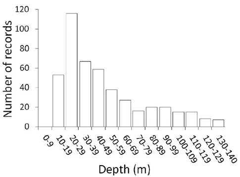
taxifolia are invasive species able to grow also in deep waters where coralligenous thrives, thus inhibiting growth of the main bioconstructors and altering communities’ composition. Although there is an overall knowledge concerning coralligenous buildups, one of the major gaps is the lack of cartographical data related to their distribution and extent at smaller scale (UNEP-MAP-RAC/SPA, 2008). Most of the research studies have been carried out in the north-western of Mediterranean Sea, in the eastern Adriatic Sea and around Apulian coasts. Only a few studies derive from research carried out in the Aegean-Levantine sub-region and there is an absolute lack of information about coralligenous in the southern and in the eastern part of Mediterranean Basin (Agnesi et al., 2008). The absence of data in many areas and the fragmentary nature of the available data are probably due to the lack of standardized protocols for mapping, characterization and monitoring of assemblages because of difficult accessibility of coralligenous habitat and high heterogeneity of the hosted communities. The depth where coralligenous buildups thrive is often a constraining factor in terms of practicality during diving operations due to diver safety issues. This means that most of the studies carried out on coralligenous formations are confined to the first 50 m of the water column (fig. 2.1).
32
Research works involving scientific divers at depths greater than 50 m are still few (i.e. Cerrano et al., 2014). Rapid development of remote sensing techniques has opened new perspective in mapping coralligenous biodiversity, condition and extent at different scales (Zapata et al., 2013). Recently acoustic sensors, remote-operated vehicles and optical methods are widely used for collecting data without impact on the seabed. These facilities allow post-processing of gathered data reducing the time-consumption of field activities but increasing the costs of the investigations. While using these techniques is now easier to achieve an extensive data collection, it is also true that the quality and the details of the data acquired in situ by scientific divers are not matched by remote sensing methodologies. Thus the purposes of the surveys and the scale of detail to reach become key-elements to be defined before choosing the methods to be used and starting the investigations.
Numerous initiatives, formulated during the last decade, have highlighted the importance of identifying coralligenous and other bio-concretions distribution throughout the whole Mediterranean Sea. In the document prepared for the Regional Activity Centre for Specially protected Areas (RAC/SPA) in 2009, Agnesi et al. carried out a Mediterranean bibliographic census in order to build a specific GIS database containing all available cartographic data on coralligenous habitats and other bioconcretions in the Mediterranean. They analyzed 524 scientific documents published until the end of October 2008 to produce 25 Data Sheets of the calcareous concretions’ distribution within the whole Basin (i.e. fig. 2.2).
33
Figure 2.2 – Examples of data sheets of concretions’ distribution from Agnesi et al. (2009).
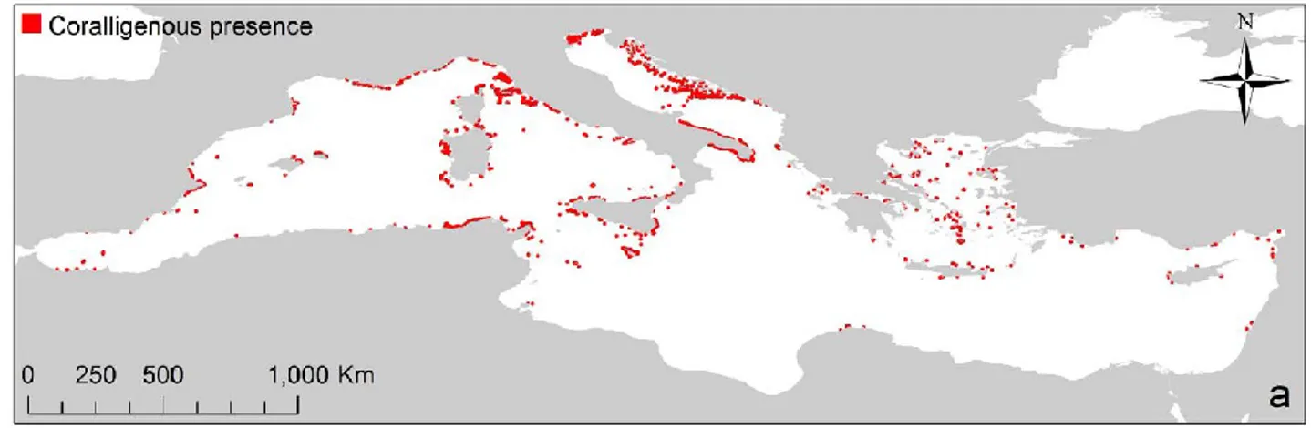
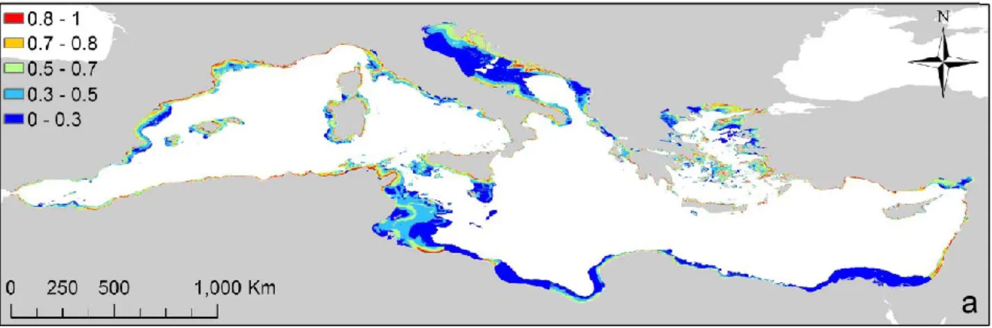
In the 2014, an additional contribution came from the work of Martin et al. (2014). They have updated the distribution map of coralligenous assemblages for the entire Mediterranean collating heterogeneous datasets from a total of 17 countries. The coralligenous outcrops dataset was composed of 4,293 points, 12 lines and 23,632 polygons for a total surface area of 2,263.4 km2 (points and lines were not considered) and they estimated that datasets provided information for approximately 30% of the Mediterranean coasts between 10 and 140 m of depth. The resulting small-scale map is shown here below (fig. 2.3).
Figure 2.3- Occurrence of coralligenous outcrops across the Mediterranean Sea from the review work of Martin et al. 2014.
It can be noted that the scientific information is unevenly distributed and the major research effort has taken place especially in the western part of the basin. The map provides an overview of the distribution of this habitat along the Mediterranean coasts but does not take into account the difference between the two main typologies of coralligenous: banks and rims. However, the available spatial data indicate that these formations widely occur in the whole Mediterranean Sea. The emerging trend of the recent years is the integration of available dataset with distribution modelling techniques. Distribution modelling tools for predicting the distribution from a set of records and environmental predictors provide a useful way to synthesize the information from scattered samples into rationale maps (Reiss et al., 2014). Moreover predictive modelling is also useful to identify most suitable areas for coralligenous habitat presence and to address preliminary
34
surveys especially in deep environments. Recent research studies focused on bio-constructions distribution predictive modelling in Mediterranean Sea (i.e. Zapata et al. 2014, Martin et al. 2014). Martin et al. (2014), into his recent work, have produced the first continuous distribution map of coralligenous assemblages across the entire Mediterranean Sea through predictive modelling techniques based on environmental predictors. The map below shows the probability of occurrence of coralligenous outcrops across the whole Mediterranean Basin (fig. 2.4).
Figure 2.4 - Occurrence probability map for coralligenous assemblages throughout the Mediterranean Sea (from Martin et al., 2014).
They used six variables to model the occurrence of coralligenous outcrops: bathymetry, slope of the seafloor, nutrient input, euphotic depth, phosphate concentration and sea surface current. They also found that the main three predictors were bathymetry, slope and nutrient input contributing for 84.1% to the model (respectively 37.4%, 31.9% and 14.8%). The predicted areas were consistent with the already available information and the model suggested unexplored areas where focus future research studies.
35
3
COASTAL HYDRODYNAMICS AND PROCESS-BASED NUMERICAL
MODELLING: THE BASICS
Many hydrodynamic processes that occur in the coastal region are examined by modeling techniques being able to reproduce the main phenomena involved in the wave propagation toward the coastline. Wave modeling attempts to depict the sea state and predict the evolution of waves using numerical techniques. Numerical models are useful to obtain solutions within the continuous spatio-temporal domain. These are discretization methods by which it is possible to obtain a reliable and approximated solution in a finite number of points (space) and instants (time). As already mentioned in the paragraph 1.5, today numerical models are increasingly being used in place of traditional physical models because of their versatility, reliability and cheapness.
The waves are the expression of forces whose action, by acting on the water in the normal and tangential direction, leads to warp the free surface of the water. When wind waves are generated by a long fetch or a distant storm, they usually consist of a wide range of wave frequencies. The wave component with a higher frequency propagates at a slower speed than those with lower wave frequencies. In deep waters, the waves are not affected by the bathymetry. As soon as the depth decreases and reaches a certain value, the wave motion undergoes a change in its propagation. The depth where this phenomenon appears mainly depends on the characteristics of the waves. Upon entering in shallower water, the generated waves are either refracted by the bathymetry or current, or diffracted around abrupt bathymetric features. A portion of wave energy is reflected back to the deep sea (Liu & Losada, 2002). During their shoreward propagation, waves modify their amplitude and height and loose some of their energy through dissipation near the bottom. The amount of the dissipation is function of both bottom roughness, reducing near-bed velocity, and wave’s parameters (amplitude, length, height). Approaching the coastline, the seabed becomes shallower causing an increase in wave amplitude and a decrease in wavelength. Because the wave speed is proportional to the square root of the water depth in very shallow water, wave profile becomes steeper and the front face of the wave moves at a slower speed than the wave crest, leading to the
36
overturning of the wave crest and hence to wave breaking. Thus the wave energy is dissipated. The turbulence associated with breaking waves is responsible not only for the energy dissipation but also for sediment movement in the surf zone (fig. 3.1).
Figure 3.1- Beach profile zonation scheme.
3.1 Wave propagation: hypotheses and parameters
In the discussion about the wave propagation phenomena, the basic assumption is to consider wave
as regular and progressive (fig. 3.2). This type of wave reveals both temporal and spatial periodicity.
Figure 3.2 - Regular wave representation.
In order to describe it, we will consider an approximation effective for infinitesimal waves using a perturbation method truncated at the first term (first-order approximation).
37
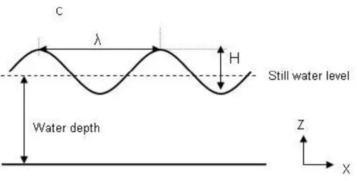
A regular wave can be mathematically described by a sinusoidal function, and it is characterized by different elements:
- Wave Crest: highest point of the wave;
- Wave Trough: lowest point of the wave;
- A: Wave Amplitude = distance between free surface and undisturbed level (equilibrium point) [m];
- H: Wave Height = vertical distance between wave crest and trough [m];
- L: Wave Length = horizontal distance between two consecutive crests (or consecutive troughs) [m];
- T: Wave Period = the time spent by wave to complete one cycle. The period can be also defined as
time (expressed in seconds) required to a crest to travel a distance equal to the wavelenght [s]; - c: Velocity of propagation or celerity= 𝑳𝑻 [m s-1];
- σ: Angular frequency = 𝟐𝝅𝑻 [s-1]; - K: Wave number = 𝟐𝝅𝑳 [m-1];
- Θ: Wave phase = (KX-σT) [adimensional]
Sea waves are also known as dispersive waves because σ and K (angular frequency and wave number) are related by the following dispersion equation:
𝝈𝟐 = 𝒈𝑲𝒕𝒂𝒏𝒉(𝑲𝒉)
Solving for L (wave length), we find the equation:
𝑳 =𝒈𝑻
𝟐
𝟐𝝅 𝐭𝐚𝐧 𝒉 ( 𝟐𝝅
𝑳 𝒉)
Solving this equation for infinite and shallow depths (respectively 𝑲𝒉 → ∞ and 𝑲𝒉 → 𝟎): (1) For shallow depths: 𝑲𝒉 → 𝟎 𝑳 = √𝒈𝒉𝑻
(2) For infinite depths: 𝑲𝒉 → ∞ 𝑳𝟎= 𝒈𝑻𝟐𝝅𝟐
The consequence of this relation is that L decreases with the depth. Solving for C we obtain:
38
𝑪 = √𝒈𝒉 (2) For infinite depths:
𝑪𝟎=𝒈𝑻 𝟐𝝅
Group velocity is defined as the speed at which a set of waves, characterized by different frequency and amplitude, propagates toward the coast. It is defined by the following relation:
𝑪𝑮= 𝑪 𝟐[𝟏 +
𝟐𝒌𝒉 𝒔𝒊𝒏 𝒉(𝟐𝒌𝒉)]
(1) For shallow depths: 𝑲𝒉 → 𝟎 𝒄𝑮= 𝒄
(2) For infinite depths: 𝑲𝒉 → ∞ 𝒄𝑮𝟎 = 𝒄𝟐
Being 𝑪 ≥ 𝑪𝑮, each wave travels faster than the group so that, once it arrived in front of the group, the wave disappears within it. The continuous formation of waves in its tail ensures the existence/maintenance of the group. Group velocity represents the velocity of propagation of the wave energy.
3.2 Wave energy
The amount of energy contained in a regular wave is given by the sum of kinetic and potential energy:
𝑬𝑻𝑶𝑻 = 𝑬𝒄+ 𝑬𝑷
At the first order of approximation, the potential energy is equal to the kinetic one: 𝑬𝒑 = 𝑬𝒄 = 𝟏
𝟏𝟔𝝆𝒈𝑯𝟐 Thus:
𝑬𝑻𝑶𝑻 = 𝑬 =𝟏 𝟖𝝆𝒈𝑯𝟐 Where wave energy is defined as density of energy.