Earth observation
advancements in
a changing world
Edited by Chirici G. and Gianinetto M.
AIT Series
Trends in earth observation
Earth observation advancements in a changing world
__________________
Edited by
Gherardo Chirici and Marco Gianinetto
Volume 1 - Published in July 2019
Edited by Gherardo Chirici and Marco Gianinetto
Published on behalf of the Associazione Italiana di Telerilevamento (AIT)
Via Lucca 50
50142 Firenze, Italy
ISSN 2612-7148
ISBN 978-88-944687-1-7
DOI: 10.978.88944687/17
All contributions published in the Volume “Earth observation advancements in a changing world” were
subject to blind peer review from independent reviewers.
Publication Ethics and Publication Malpractice Statement
Editors, Reviewers and Authors agreed with Publication Ethics and Publication Malpractice Statement
© 2019 by the authors; licensee Italian Society of Remote Sensing (AIT).
This Volume is an open access volume distributed under the terms and conditions of the Creative Commons
Attribution license (http://creativecommons.org/licenses/by/4.0/).
INTEGRATING REMOTE SENSING DATA FOR THE ASSESSMENTS OF COASTAL
CLIFFS HAZARD: MAREGOT PROJECT
G. Deiana1, M. T. Melis1*, A. Funedda , S. Da Pelo1 1, M. Meloni1, L. Naitza1, P. Orrù1, R. Salvini2, A. Sulis1
1 Department of Chemical and Geological Sciences, Università degli Studi di Cagliari, Cittadella Universitaria – S.S. 554 bivio per
Sestu I-09042 Monserrato (CA), Italy – (titimelis, afunedda, sdapelo, orrup, asulis)@unica.it – (gdeiana80, lnaitza)@gmail.com – [email protected]
2 Department of Environment, Earth and Physical Sciences and Centre of GeoTechnologies, University of Siena, San Giovanni
Valdarno, Arezzo, Italy – [email protected]
KEY WORDS: Geology, Landslides, Coastal Erosion, Geomorphology, Sardinia ABSTRACT:
The assessment of cliffs instability to understand the dynamics of erosive phenomena and the dynamics of coastlines, in relation to the geomorphological and hydrodynamic characteristics of the coast is an important challenge worldwide, mainly where coastal retreat imply an economic impact. The MAREGOT Project (MAnagement des Risques de l'Erosion cotière et actions de GOuvernance Transfrontalière – “Managing the Risks of Coastal Erosion and Cross-border Governance Actions), funded under the Programme: 2014 - 2020 INTERREG V-A Italy - France (Maritime), aims at the joint prevention and management of the risks arising from coastal erosion in the cooperation area. In this context, a methodology consisting in the characterization of morphological and geological features collecting data from remote and proximal sensing sensors either on the sub-aerial or in the submerged cliff has been proposed. These data will be integrated by direct observation and surveys of the different geological features and with laboratory analysis of the geotechnical properties of sampled rocks and terrains. The main aim of this study is to integrate data acquired by different sensors as optical and Lidar data, side scan sonar and multibeam information to propose methodologies to assess and monitor coastal cliff landslide susceptibility.
1. INTRODUCTION 1.1 Coastal erosion
Coastal morphology is generally related to the interaction of marine and gravitational processes that act on outcropping lithologies, but it is impossible to define with certainty the extent to which the triggers affect the system. The collapses that occur along the cliff are episodic, discontinuous in time and in space, and occur mainly in very fractured rock masses in correspondence of large storms (Andriani & Walsh, 2007, Paronuzzi, 2010, Budetta & Nappi, 2011; Martino & Mazzanti, 2014). The vulnerability of coastal cliffs is a very important issue as sea cliffs occur along about 80% of the world’s shorelines (Emery & Kuhn, 1982).
The coastal retreat of rocky cliffs is influenced by the geology, particularly by the structure and lithology of rock formations that crop out on the coast and their response to local weathering. Geological setting with its complete characterization has to be analysed with different techniques aiming to reconstruct the past evolution and future dynamics that will affect the coasts, considering the environments emerged and submerged as a single evolutionary system.
In recent years, investigative techniques on coastal landslides have been developed with the contribution of new Remote Sensing tools (Budetta et al., 2000; Fall et al., 2006; De Blasio & Mazzanti, 2010; De Vita et al., 2012; Budetta & De Luca, 2015; Ružić, et al., 2015; Budetta et al., 2016). However, currently there are no well-defined investigative protocols. Existing studies often do not follow uniform methodologies, mainly due to lack of knowledge and complexity in collecting data on the processes that generate coastal erosion (Sunamura, 1977; 1983; 1992). The proposal of a methodology for the characterization of geological features, collecting data from remote and proximal sensing sensors, either on the sub-aerial or in the submerged cliff is part of MAREGOT Project (Managing the Risks of Coastal
* Corresponding author
Erosion and Cross-border Governance Actions). This project aims at the joint prevention and management of the risks arising from coastal erosion in the cooperation area. Five pilot sites were chosen to test the methodology. In this paper, the study carried out in the area of “Sella del Diavolo” on the South coast of Sardinia (Italy) is presented.
2. STUDY AREA
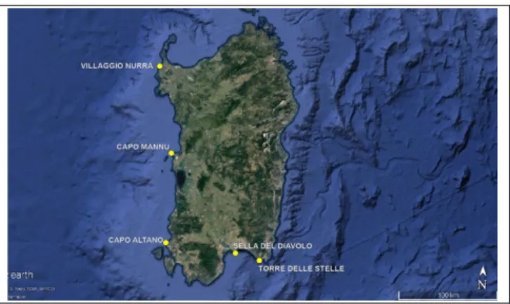
Sardinia is the second largest island of the Mediterranean area, but holds the record of having the longest coastline perimeters. Rocky coasts, cliffs or slopes, represent more than 68% of the coastal areas (ISPRA, 2016). Moreover, the geological complexity of Sardinia makes it suitable to represent most of the cliff environments present in the Mediterranean area (Carmignani et al., 2016). Therefore, sites from the North-west to the Southeast, along the coast of Sardinia, have been chosen to test the proposed methodologies (Figure 1).
Figure 1. Study sites along the coast of Sardinia
They are representative of sites where different lithology, coastal dynamic, and landslides occur. Lithology ranges from metamorphic rocks of the Palaeozoic Basement (Villaggio Nurra, Figura 2), where landslides phenomena occur mainly as rock slide, to the aeolian succession, made up from Upper Pliocene-Lower Pleistocene sandstones (Capo Mannu) where rockfalls, topples and slumping are more frequent.
Figure 2. Study site: Villaggio Nurra
In the Oligo-Miocene volcano-sedimentary succession (Capo Altano) and in the Upper Carboniferous-Permian plutonic complex mainly made up by granodiorites, tonalites, gabbro and intrusive dikes (Torre delle Stelle, Figura 3), a gradual retrograde erosion of the cliffs due to gravitational processes as rockfall, topples and wedges failure develops.
Figure 3. Study site: Capo Mannu
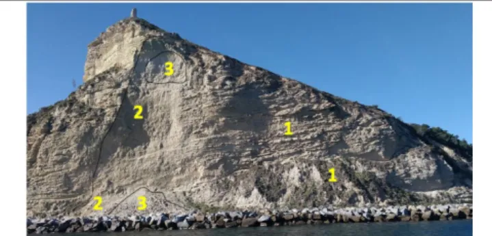
The pilot site of "Sella del Diavolo", presented in this paper (Figura 4), is located on the southern coast of Sardinia, where Upper Miocene sedimentary rocks and Quaternary deposits crop out. Miocene succession mainly consists of sandstones at the base, overlie by bioclastic limestones and ancient landslide deposits.
Figure 4. Site of Sella del Diavolo. Sliding landslides developed along sub-planar surfaces of fracturing and collapses
have thirty-year recurrence time. Collapsed landslide deposits: 1) altered main scarp and the deposit colonized by vegetation evolved between 1940 and 1950; 2) main scarp and deposit at the foot of the landslide of July 2, 1987; 3) main scarp and deposit of 21 February 2017. In the foreground the protective
breakwater, put in place after the event of 1987.
The Pleistocene deposits consist of littoral conglomerates and sandstones. The Holocene deposits are mainly gravitational sediments originating from the dismantling and erosion of nearby outcropping formations. The study area is affected by rockfalls, topples, debris flows and slides, which in the past caused damage to people.
3. METHODOLOGY
The methodological approach aiming to define the morphological model is discussed. This model will be used for the definition of the potential instability model of the coastal cliffs, starting from a deep knowledge of the geological processes occurring at the slopes. The processing of the data and the proposed protocol as based on an integrated multidisciplinary survey considering the emerged and submerged areas as a single system of evolutionary dynamics.
Vertical surfaces, sloping or very steep slope, are not visible from the maps returned by zenith acquisitions and therefore must be detected with specifically positioned measuring systems. Moreover, as these areas are often not accessible, surveys require remote sensing systems to build a DEM. This is a widely diffused tool for geomorphological mapping and landslide susceptibility/hazard assessment, mainly because it provide the foundation for deriving surface morphological parameters such as slope aspect, curvature, slope profile and catchment areas (Calligaris et al., 2013).
Boat and unmanned aerial vehicle (UAV) digital photogrammetric surveys have been proposed as a new approaches to extract 3D point clouds of coastal cliffs (Esposito et al., 2017; Salvini et al., 2011). Observations could be conditioned by the visibility cones, thus data acquisition has to be plan carefully. According to these methods, an acquisition campaign has been carried out in the Sella del Diavolo study site. The survey provided cliff surface data capture using both photogrammetry from boat and Terrestrial Laser Scanner (TLS) systems. Geo-referencing target points using GNSS and total station instruments (for TLS) ensured survey geometry and position accuracy. Collected data have been then processed using commercial and free 3D data computing software, obtaining dense point clouds as surfaces models of the cliffs. For the site of Sella del Diavolo, a TLS data subset containing around 23.5 M points has been chosen for the cliff geometric characterization. Applying the kd-tree algorithm of the free 3D data software “CloudCompare v2.9.1”, 9,355 facets in the cliff have been detected setting 20 degrees of maximum variation. Thirty-six main sets of surfaces with dip and dip direction ranging in a neighbourhood of 30 degrees were identified. Resulting surfaces have been statistically analysed, providing the main orientations occurring on the cliff.
In the submerged sector of the Sella del Diavolo, a Single Beam (HYDROTRAC ™ II - 200 Khz) and Side Scan Sonar (StarFisch 990F - 1 Mhz) data surveys with total coverage were carried out. The correct positioning was guaranteed by the GPS system. The Single Beam data covered an area of 3560 km2 with tracklines
orthogonal to the coast. Cleaning and filtering of Single Beam data were performed by PDS2000 software, and Global Mapper was used to provide the bathymetric map. The bathymetry was plotted on a grid data of 0.5 m node spacing as contour plot to display detailed bathymetric information, as slope value and as illuminated 3D perspective view to visualize prominent features along sea floor.
4. PRELIMINARY RESULTS
The analysis of the facets of the Sella del Diavolo site derived from TSL point clouds leaded to the detection of surfaces
G. Deiana et. al
characterizing the cliff geometry. Facets discriminated homogeneous surface zones, located on the centre of the cliff wall, from those more heterogeneous on the cliff foot and on the most peripheral areas. The homogeneous surfaces (in yellow and in blue in Figure 6) represent the most frequent dip directions, counting around 5,450 facets over 9,355 and covering an overall surface of about 3,505 m2 over 19,559 m2 of the cliff.
These sets mainly occur in correspondence of the collapse areas of the landslides fallen in 1987 and 2017 (Figure 5).
Figure 5. Facets extracted by CloudCompare from Terrestrial Laser Scanner (TLS) point cloud of the “Sella del Diavolo” site The stereographic projection of poles diagram in Figure 6 shows the spatial distribution of the poles of the facets according to the dip direction. The bar histogram shows that the dominant dip direction distribution includes values between 35.9 and 71.8 degrees, and then from 71.8 to 107.7 degrees.
Figure 6. Stereographic projection of poles diagram (equiangular projection on lower hemisphere) and bar histogram
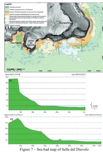
of facet distribution of “Sella del Diavolo” site The analysis of data in the submerged sector allowed to define detailed distribution of incoherent sediments, the landslide deposits at the base of the cliffs, rock outcrops and the main morphologies of the seabed (Figure 7).
In the western sector, a subvertical cliff exposed to east has been detected. In this area, the submerged part of the cliff is sub-vertical and reaches the maximum depth of -8 ÷ -9 m. Fall and toppling deposits, characterized by blocks with dimensions between few decimeters and 1÷2 meters, occur at the base of the cliff.
The morphometric survey of tidal notches detectable in this area confirms that the amplitude is proportional with the magnitude of tidal oscillation, that the point of maximum depth of incision corresponds to the middle sea level, and that greater incisions are located close at submarine resurgences of fresh water (Antonioli el al., 2015). The upper limit of the prairies of Posidonia oceanica is about 35 meters from the coast and detectable at -10.5 meters depth. Large areas with coarse and medium sands with predominant lithoclastic composition occur in the central sector, dominated by a low slope area, at a depth between -1 m and -8 meters. This characteristic can be correlated with the cliff exposure to the maximum wave energy that reworks quickly the landslide deposits at the base of the rocky slopes. In fact, in the emerged part, evidences of accelerated erosion processes (gullies) have been detected, also typical of weakly cemented and medium-low permeable soils. The presence of large blocks,
located at depths between -2 and -5 meters, which rise up to 3 meters above sea level can be related to paleo-rockfall deposits. The elaboration of rockfall deposits deriving from Miocene sandstone (Arenarie di Pirri Fm.) and the dynamic of currents formed megaripples with a wavelength of 0.5 ÷ 1 m (Figure 8).
Figure 7 – Sea bad map of Sella del Diavolo
In the north-eastern sector of the surveyed area, the sea beds in front of the cliff are characterized by the presence of an abrasion platform detectable at a depth of -2.5 m and 4 m. It is a morphology engraved on the rocky substrate and with a polycyclic evolution starting from the last sea-level rise - Stage 5.
Figure 8 - Side Scan Sonar image (1MHz – 8 meter depth) – Sella del Diavolo cliff. 1) Megaripples structures on Silicoclastic sediments (λ= 0.5÷1 m); 2) elaborated landslide deposits; 3) Block fall (d=4 m h= 3m); 4) Block fall (d=6 m h=
5m); 5) Posidonia oceanica on wave-cut platform.
Integrating remote sensing data for the assessments of coastal cliffs hazard: MAREGOT project
A strong correlation between the evolution of the perilitorial rock platforms (elevation, slope, continuity, integrity, height and rate of inner margin retreat) with exposure to extreme event has been observed, according to what described by Chelli et al. (2010) and Pappalardo et al. (2016).
On the summit surface of the abrasion platform, erosion pits and canals morphologies occur, which are linked to the movement of deposits at the base of the cliff. Instead, on the sub-horizontal rocky surfaces at the intertidal and supralitoral band, the bio-modeling and bio-demolition processes interact each other (Pappalardo et al., 2017).
5. CONCLUSIONS
Different techniques aiming to reconstruct the past evolution and future dynamics that will affect the rocky coasts have been applied in a pilot sites in the south of Sardinia, considering the emerged and submerged coastal cliff in a single system of evolutionary dynamics.
Reconstruction of the geometry and morphologies of cliff surfaces using digital photogrammetry and TLS demonstrates that 3D models of the surface can be obtained with a good accuracy. Moreover, once the GPS points are fixed and known, it can be proposed as a monitoring system for large areas as the acquisition and processing of data is quite simple.
The comparison of point clouds derived from photogrammetry and terrestrial laser scanner is ongoing. For areas that are not completely accessible, the acquisition by UAV will be mandatary to obtain the complete point clouds without blank points, as planned in the next steps of the MAREGOT project.
Single Beam and Side Scan Sonar surveys allowed mapping submerged area close to the cliff and recognizing main morphological features. Main identified morphologies are coherent with processes observed in the exposed cliff, pointing out a strong correlation between the evolution of the perilitorial areas exposure to extreme events.
ACKNOWLEDGEMENTS
MAREGOT is a strategic project of INTERREG Italy-France Maritime 2014.2020, Cross-border Program co-financed by the European Regional Development Fund (ERDF) under the European Territorial Cooperation (ETC) objective.
REFERENCES
Andriani GF, Walsh N., 2007. Rocky coast geomorphology and erosional processes: a case study along the Murgia coastline south of Bari, Apulia- SE Italy. Geomorphology 87(3): 224–238. Antonioli F., Lo Presti V., Rovere A., Ferranti L., Anzidei M., Furlani S., Mastronuzzi G., Orru P.E., Scicchitano G., Sannino G.M., Spampinato C.R., Pagliarulo R., Deiana G., De Sabata E., Sanso P., Vacchi M., Vecchio A., 2015. Tidal notches in Mediterranean Sea: a comprehensive analysis. Quaternary Science Reviews, 119: 1-19.
Budetta, P., G. Galietta, and A. Santo, 2000. A methodology for the study of the relation between coastal cliff erosion and the mechanical strength of soils and rock masses. Engineering Geology 56.3-4: 243-256.
Budetta P, Nappi M., 2011. Heterogeneous rock mass classification by means of the geological strength index: The San Mauro formation (Cilento, Italy). Bull Eng Geol Environ 70:585–593. doi:10.1007/ s10064-011-0351-1
Budetta, P., & De Luca C., 2015. Wedge failure hazard assessment by means of a probabilistic approach for an unstable sea-cliff. Natural Hazards 76.2: 1219-1239.
Calligaris C., Poretti G., Tariq S., Melis M.T., 2013. First steps towards a landslide inventory map of the Central Karakoram National Park. European Journal of Remote Sensing, 46: 272-287.
Carmignani L., Oggiano G., Funedda A., Conti P., Pasci S., 2016 The geological map of Sardinia (Italy) at 1:250,000 scale. Journal of Maps, 12, 5: 826–835. http://dx.doi.org/10.1080/17445647.2015.1084544
Chelli A., Pappalardo M., Arozarena Liopis I., Federici P.R. 2010. The relative influence of lithology and weathering in shaping shore platforms along the coastline of the Gulf of La Spezia (NW Italy) as revealed by rock strength. Geomorphology 118: 93–104.
De Blasio F.V. & Mazzanti P., 2010. Subaerial and subaqueous dynamics of coastal rockfalls. Geomorphology, 115: 188-193. De Vita P., Cevasco A., Cavallo C., 2012. Detailed rock-failure susceptibility mapping in steep rocky coasts by means of non-contact geostructural surveys: the case study of the Tigullio Gulf (Eastern Liguria, Northern Italy). Natural Hazards and Earth System Sciences, 12, 867–880. www.nat-hazards-earth-syst- sci.net/12/867/2012/.
Emery, K. O. and Kuhn, G. G., 1982. Sea cliffs: Their processes, profiles, and classification, GSA Bulletin, 93, 644–654.
Esposito G., Salvini R., Matano F., Sacchi M., Danzi M., Somma R., Troise C., 2017. The Photogrammetric Record 32(160): 459–479. doi: 10.1111/phor.12218
Fall, M., R. Azzam, and Noubactep C., 2006. A multi-method approach to study the stability of natural slopes and landslide susceptibility mapping. Engineering geology 82.4: 241-263. ISPRA, 2017. Linee Guida Nazionali per la difesa della costa dai fenomeni di erosione e dagli effetti dei cambiamenti climatici. Tavolo Nazionale sull’erosione costiera MATTM-Regioni: 312 http://www.erosionecostiera.isprambiente.it/files/linee-guida-nazionali/TNECLLGGNazionaliDifesadellaCostadallErosione_ mar2017.pdfclimatici. Last view 01/04/2019 in italian
Martino, S., and Mazzanti P., 2014. Integrating geomechanical surveys and remote sensing for sea cliff slope stability analysis: the Mt. Pucci case study (Italy). Natural Hazards and Earth System Sciences 14.4: 831.
Pappalardo M., Buehler M., Chelli A., Cironi L., Pannacciulli F. & Qin Z. 2016. Quantitative Estimate sof Bio-Remodeling on Coastal Rock Surfaces. J. Mar. Sci. Eng., 4(2): 37.
Pappalardo M., Cappietti L., Arozarena Llopis I., Chelli A. & De Fabritiis L., 2017. Development of Shore Platforms along the NW Coast of Italy: The Role of Wind Waves. Journal of Coastal Research: 33, 5: 1102-1112.
Paronuzzi P., 2010. Flexural failure phenomena affecting continental Pleistocene deposits along coastal cliffs (Croatia). Ital J Eng Geol Environ 1: 93–106.
G. Deiana et. al
Ružić, Igor & Marović, Ivan & Benac, Čedomir & Suzana, Ilic., 2015. A stability assessment of coastal cliffs using digital imagery. Acta geotechnica Slovenica, 12: 25-35.
Salvini, R., Francioni, M., Riccucci, S., Fantozzi, P. L., Bonciani, F. and Mancini, S., 2011. Stability analysis of “Grotta delle Felci” cliff (Capri Island, Italy): structural, engineering– geological, photogrammetric surveys and laser scanning. Bulletin of Engineering Geology and the Environment, 70(4): 549–557.
Sunamura, T., 1977. A relationship between wave-induced cliff erosion and erosive force of waves. J. Geol. 85: 613–618. Sunamura, T., 1983. Processes of sea cliff and platform erosion. In: Komar, P.D. (Ed.), CRC Handbook of Coastal Processes and Erosion. CRC Press, Boca Raton, FL: 233–265.
Sunamura, T., 1992. The Geomorphology of Rocky Coasts. Wiley, Chichester.
This work is licensed under a Creative Commons Attribution-No Derivatives 4.0 International License.
Integrating remote sensing data for the assessments of coastal cliffs hazard: MAREGOT project