The Geological Society of America Bulletin
An exceptionally long paleoseismic record of a slow-moving fault: the Alhama de
Murcia fault (Eastern Betic Shear Zone, Spain)
--Manuscript
Draft--Manuscript Number: B30558R2
Full Title: An exceptionally long paleoseismic record of a slow-moving fault: the Alhama de
Murcia fault (Eastern Betic Shear Zone, Spain)
Short Title: Paleoseismicity of the AMF-southern tip
Article Type: Article
Keywords: paleoearthquake chronology; splay-structure; Quaternary geomorphology; Infrared
Stimulated Luminescence (IRSL); fault segmentation.
Corresponding Author: Maria Ortuño, Ph.D.
Universidad Nacional Autonoma de Mexico Queretaro, Queretaro MEXICO
Corresponding Author's Institution: Universidad Nacional Autonoma de Mexico
First Author: Maria Ortuño, Ph.D.
Order of Authors: Maria Ortuño, Ph.D.
Eulalia Masana, Dr.
Eduardo García-Meléndez, Dr. José Martínez-Díaz, Dr. Petra Štěpančíková, Dr. Pedro P. Cunha, Dr. Reza Sohbati, Ph.D. student Carolina Canora, Dr. Jan-Pieter Buylaert, Dr. Andrew S. Murray, Dr. Manuscript Region of Origin:
Abstract: Most catastrophic earthquakes occur along fast moving faults although some of them
are triggered by slow moving ones. Long paleoseismic histories are infrequent in the latter faults. An exceptionally long paleoseismic record (more than 300 ka) of a slow moving structure is presented: the southern tip of the Alhama de Murcia fault (AMF, Eastern Betic Shear Zone), characterized by morphological expression of current tectonic activity and by a lack of historical seismicity. At its tip, the fault divides into a splay with two main faults bounding the Góñar fault system. At this area, the
condensed sedimentation and the distribution of the deformation in several structures provided us with more opportunities to obtain a complete paleoseismic record than at other segments of the fault. The tectonic deformation of the system was studied by an integrated structural, geomorphological and paleoseismological approach.
Stratigraphic and tectonic features at six paleoseismic trenches indicate that old alluvial units have been repeatedly folded and thrusted over younger ones along the different traces of the structure. The correlation of the event timing inferred for each of these trenches and the application of an improved protocol for the Infrared Stimulated Luminescence (IRSL) dating of K-feldspar allowed us to constrain a paleoseismic record as old as 325 ka. A minimum of 6 possible paleoearthquakes of Mw= 6 - 7 and a maximum mean recurrence interval of 29 ka were identified. This provided
compelling evidence of the underestimation of the seismic hazard in the region.
Suggested Reviewers: Pilar Villamor, Dr.
Manager, Institute of Geological and Nuclear Sciences, New Zeland [email protected]
She is an expert in paleoseismology and focused a part of her research on slow moving active faults
Pablo Silva, Dr.
Professor, Universidad de Salamanca, Spain [email protected]
His Ph.D thesis included the neotectonics of the study area of this manuscript. Also, he has performed several of the paleoseismological studies discussed in this manuscipt. Tom Rockwell, Dr.
Professor, San Diego State University [email protected]
He has a wide background on the paleoseismological study of faults, which include faults in the Iberain Peninsula. Among his main research interest are earthquake histories and neotectonics.
Opposed Reviewers: Response to Reviewers:
All the minor changes suggested by the Associated Editor have been incorporated to the revised version of the manuscript.
We would like to add a short comment to the following changes:
1)line 290 "channel" for "river path" and delete "the" before Bermeja and "the" before Casas.
response: We have removed the article “the” before the name for all the “creeks” throughout the manuscript, we have also replaced “path” or “drainage path” by “channel”.
2)line 302 "thinner conglomerate?" what is meant by this?
response: We wanted to say small-size (fine) conglomerate, but since no size is specified in the description of the other material, we have remove it. It´s not relevant for that description.
3)line 309 how can hills formed by activity on the fault be displaced by it? response: We have clarified this issue by adding:
"This displacement is probably related to the folding of the fault trace, so that the NE-SW oriented segment has a major strike-slip component, whereas the ENE-WNE-SW segment is active as a major reverse fault"
4)line 361 'extruded backwards'? What is meant by this?
response: To clarify this matter, we have change slightly the sentence:
"The Góñar faults, located between these faults dip steeply to the NE so that they probably merge at depth into the SAMF (Fig. 3). The blocks bounded by the Góñar faults have been uplifted to accommodate the shortening in the area"
5)line 489 replace "by" with "as"
response: Besides replacing "by" with "as", we have realized that there was an error in this sentence, which has been corrected as follows:
"The age of these two events can only be constrained as predating unit C1 (at the Era trench, 149 – 135 ka pIRIR) and postdating the unit before unit B, unit Q at Gabarrones (274 – 242 ka pIRIR)"
Cover Letter
1
An exceptionally long paleoseismic record of a slow-moving
1
fault: the Alhama de Murcia fault (Eastern Betic Shear
2
Zone, Spain)
3
María Ortuño
a,b, Eulalia Masana
b, Eduardo García-Meléndez
c, José
4
Martínez-Díaz
d, Petra Štěpančíková
e,
5
Pedro P. Cunha
f, Reza Sohbati
g, Carolina Canora
d, Jan-Pieter
6
Buylaert
g, Andrew S. Murray
g7
a
Centro de Geociencias, Universidad Nacional Autónoma de México, Blvd.
8
Juriquilla, 3001, 76230, Juriquilla, Querétaro, México
9
b
RiskNat group, Dep. de Geodinàmica i Geofisica, Universitat de Barcelona, Martí
10
i Franquès s/n, 08028 Barcelona, Spain
11
c
Área de Geodinámica Externa, Facultad de Ciencias Ambientales, Universidad.
12
de León, Campus de Vegazana, s/n, 24071 León, Spain
13
d
Dep. de Geodinámica, Universidad Complutense de Madrid, C/ Jose A. Novais
14
28040 Madrid, Spain
15
e
Institute of Rock Structure and Mechanics, Academy of Sciences of the Czech 16
Republic, V Holešovičkách 41, 18209 Prague 8,Czech Republic
17
f
Dep. of Earth Sciences, IMAR-Marine and Environmental Research Centre,
18
Universidade Coimbra, Largo Marquês de Pombal, 3000-272 Coimbra, Portugal
19
g
Nordic Laboratory for Luminescence Dating, Dep. Earth Sciences, Aarhus
20
University, Risø DTU, DK-4000 Roskilde, Denmark
21 22
*
Corresponding author. Tel.: Tel.: +52 (442) 238-1104 Ext. 104; fax: +52 (442) 23
238-1124. E-mail address [email protected] (M.Ortuño) 24
*Manuscript
2 25
Abstract
26
Most catastrophic earthquakes occur along fast moving faults although some of them 27
are triggered by slow moving ones. Long paleoseismic histories are infrequent in the 28
latter faults. An exceptionally long paleoseismic record (more than 300 ka) of a slow 29
moving structure is presented: the southern tip of the Alhama de Murcia fault (AMF, 30
Eastern Betic Shear Zone), characterized by morphological expression of current 31
tectonic activity and by a lack of historical seismicity. At its tip, the fault divides into a 32
splay with two main faults bounding the Góñar fault system. At this area, the 33
condensed sedimentation and the distribution of the deformation in several structures 34
provided us with more opportunities to obtain a complete paleoseismic record than at 35
other segments of the fault. The tectonic deformation of the system was studied by an 36
integrated structural, geomorphological and paleoseismological approach.
37
Stratigraphic and tectonic features at six paleoseismic trenches indicate that old 38
alluvial units have been repeatedly folded and thrusted over younger ones along the 39
different traces of the structure. The correlation of the event timing inferred for each of 40
these trenches and the application of an improved protocol for the Infrared Stimulated 41
Luminescence (IRSL) dating of K-feldspar allowed us to constrain a paleoseismic 42
record as old as 325 ka. A minimum of 6 possible paleoearthquakes of Mw= 6 – 7 and
43
a maximum mean recurrence interval of 29 ka were identified. This provided 44
compelling evidence of the underestimation of the seismic hazard in the region. 45
46 47
Keywords: paleoearthquake chronology; splay-structure; Quaternary geomorphology;
48
Infrared Stimulated Luminescence (IRSL); fault segmentation. 49
3 50
1. Introduction
51
The identification and characterization of seismogenic faults are essential in 52
areas without historical damaging seismicity, which is common in tectonic regions with 53
low deformation rates. 54
The largest possible number of seismic cycles should be analyzed in order to 55
better understand the seismic behavior of a fault. Given the length of the cycles of slow 56
moving faults (tens of thousands of years), the study of these faults entails long 57
paleoseismic histories (hundreds of thousands of years). Our study is one of the few 58
works to date that provide a long record of slow moving faults. 59
Slow moving faults are more difficult to investigate than fast moving ones 60
owing to their muted morphological expression and to the difficulty of obtaining and 61
analyzing a long paleoearthquake record. The latter drawback is not only related to the 62
time-range of applicability of the current dating methods but also to the technical 63
impracticality of excavating very deep trenches. If the seismic activity of a slow moving 64
fault is recorded on condensed sedimentary sequences (which are related to moderate to 65
low sedimentation rates), trenches of only 2-3 meters depth can provide a paleoseismic 66
record of hundreds of thousands of years. We present an example of an exceptionally 67
long paleoseismic record of a slow moving fault affecting a condensed sedimentary 68
alluvial sequence: the southern tip of the Alhama de Murcia fault (AMF). 69
In the Iberian Peninsula, the historical seismic record (ca. 700 years) is much 70
shorter than the common recurrence interval of the Iberian seismogenic faults (> 5.000 71
years). The AMF is a slow moving fault with strong morphological expression of 72
activity but with no record of historical surface rupturing earthquakes. Nevertheless, on 73
May 11th 2011, after the conclusion of this study, the AMF produced the most
4 destructive earthquake in the Iberian Peninsula since 1881 (Andalusian earthquake, 25 75
December, EMS I = X; IGN, 2010). This Mw 5.1 event left thousands of people
76
homeless and claimed 9 fatalities in Lorca. The large number of people affected and the 77
considerable economic loss caused by this moderate earthquake were mainly due to a 78
shallow focus and a high peak acceleration of the ground in the most populated areas, 79
which had been underestimated in the national seismic hazard plans. The recorded 80
magnitude was much lower than the maximum expected magnitude (M > 6) proposed in 81
this work and in earlier paleoseismic studies in different segments of the AMF (Silva et 82
al. 1997; Martínez-Díaz, 1998; Martínez-Díaz et al., 2001, 2003; Masana et al., 2004). 83
This fault could therefore cause much more damage in the future. 84
We present the results of a thorough geomorphological, structural and 85
paleoseismic study carried out at the southern tip of the AMF in the proximity of Góñar 86
(Fig. 1). We focused on this area for the following reasons: 1) it is an instrumental 87
seismic gap; 2) there are no paleoseismic studies of this segment of the fault and 3) 88
some of its geomorphological, sedimentological and geodynamical characteristics 89
favour the preservation of a more complete paleoseismic record than adjacent segments. 90
We employed an improved method of luminescence dating to K-feldspar grains 91
based on elevated temperature infrared stimulated luminescence (post-IR IRSL or 92
pIRIR) dating (Sohbati et al., 2011 and references therein). This method, described in 93
section 3, allowed us to constrain much older palaeo-earthquakes than those previously 94
dated by quartz optically stimulated luminescence (OSL) dating. The combined use of 95
these methods provided us with an exceptionally long paleoearthquake record. The 96
novel geochronological methodology could be useful in the study of surface processes 97
and Quaternary geology. 98
5 In section 6, we highlight the significance of the results in terms of 1) the 99
characteristic rupture of the faults under study 2) the segmentation of the fault system 100
during seismic events and 3) the tectonic style in the study area. The unusually long 101
paleoearthquake history is analyzed together with the histories obtained from earlier 102
studies along other sectors of the AMF and Albox faults. This comparison offers new 103
insights into the seismotectonic behavior of the faults in the Eastern Betic Shear Zone, 104
which will have a considerable impact on seismic hazard assessment. 105
106
2. Geological setting
107
The AMF is located in the eastern part of the Betic Cordillera, the northern 108
branch of the Rif-Betic alpine orogenic belt, which resulted from the early Cenozoic 109
collision between the African and Eurasian plates. The Present-day relative plate motion 110
has been estimated as 4.5-5.6 mm/a (De Mets et al., 1994; McClusky et al., 2003). 111
Within the Iberian margin, a large part of the shortening is accommodated by faults in 112
the Eastern Betics Shear Zone (EBSZ) and by internal deformation (Masana et al., 113
2004). Faults in the EBSZ (Bousquet, 1979; Banda and Ansorge, 1980; Sanz de 114
Galdeano, 1990) are mainly left-lateral strike slip structures oriented N-S to ENE-115
WSW. Active faults in the EBSZ are the AMF, Carboneras, Palomares, Carrascoy, Bajo 116
Segura and San Miguel faults (Fig. 1a). All these faults are located in the internal zone 117
of the Betic range, where the basement consists of a stack of tectono-metamorphic 118
complexes (Nevado-Filbride, Alpujárride and Malaguide complexes; Fig. 1). In the 119
eastern part of the range, the tectonic exhumation of these complexes during the main 120
post-collisional period gave rise to a series of marine-continental tectono-sedimentary 121
basins (Sanz de Galdeano and Vera, 1992; Rodríguez-Fernández and Sanz de Galdeano, 122
1992; Montenat, 1996). Most of these basins were bounded by extensional faults. 123
6 Subsequently, Neogene to Present-day tectonics reactivated many of these faults, giving 124
rise to new intramontane sedimentary basins (Montenat and Ott d‟Estevou, 1996, 125
Bardají, 1999). 126
127
2.1. The Alhama de Murcia Fault
128
The AMF is the longest fault in the EBSZ. First described by Montenat (1973) and 129
Bousquet and Montenat (1974), this fault has been considered to be one of the most 130
active faults in the Eastern Betics based on Quaternary geodynamical, 131
geomorphological and paleoseismologic data (e.g. Silva, 1994; Silva et al., 1992a, 1993, 132
1997; Martínez-Díaz, 1998, Martínez-Díaz et al., 2001; 2003; Masana et al., 2004). The 133
tectonic activity of the AMF since the Middle Miocene is characterized by oblique left-134
lateral reverse kinematics (Montenat and Ott d‟Estevou, 1996; Martínez-Díaz, 1998). 135
The Plio-Quaternary AMF extends from Alcantarilla to Lorca, along a ca. 100 136
km fault trace according to recent neotectonic studies (e.g. Silva et al., 1997, 2003; 137
Martínez-Díaz, 1998; Martínez-Díaz et al., 2003; Masana et al., 2004; Meijninger, 138
2006) although longer lengths have been proposed in earlier studies (e.g. Gauyau et al. , 139
1977; Montenant et al., 1987) (Fig. 1a). 140
The AMF has been divided into different segments on the basis of its tectonic- 141
geomorphological features, its geodynamical evolution, its subsurface geometry and its 142
historical and present-day seismicity (Silva et al., 1992a; 2003; Martínez-Díaz, 1998). 143
To these criteria, Martínez-Díaz et al. (2010) add the paleo-seismic record and 144
distinguish four segments, from N to S: Alcantarilla-Alhama (25 km); Alhama-Totana 145
(11 km); Totana-Lorca (20 km); Lorca-Góñar (40 km) (Fig. 1b). To the SW of the 146
Lorca-Góñar segment, the AMF Plio-Quaternary activity is transferred to the Albox 147
fault (Masana et al., 2005), and possibly to other active structures described by some 148
7 authors (García-Meléndez, 2000; García-Meléndez et al., 2003, 2004; Meijinger, 2006; 149
Pedrera et al., 2010). 150
151
2.2. Historical and instrumental seismicity
152
Since the beginning of the historic seismic catalog in the Iberian Peninsula, at around 153
1300 A. D. (IGN, 2010), some regions have experienced moderate to large earthquakes. 154
Although the AMF is characterized by moderate to low (Mw< 5.5) instrumental
155
seismicity, it has been identified as the possible seismogenic source of at least six 156
damaging earthquakes occurring in 1579, 1674 (three of them), 1818 and 2011. These 157
events produced the maximum Medvedev-Sponheuer-Karnik intensities (MSK, very 158
similar to MMI) between VII and VIII in Lorca in the central-southern part of the AMF 159
(Fig. 1b). In the southern part of the AMF, a lack of historical and instrumental 160
seismicity has been observed by Silva et al. (1997), Martínez-Díaz (1998) and Masana 161
et al. (2004), among others. Although other faults in the area (such as the Palomares or 162
the Albox fault) also reveal an absence of damaging historical earthquakes and a weak 163
microseismicity (Fig. 1b), they have been shown to be seismogenic faults by means of 164
paleoseismic studies (Silva et al., 1997; Masana et al., 2005). 165
166
2.3. Earlier paleoseismic surveys in the region
167
In the proximity of Góñar, seven paleoseismologic sites have been studied: La 168
Carraclaca, El Saltador, and El Colmenar sites along the AMF in the surroundings of
169
Lorca; El Ruchete and Urcal sites at the Albox fault; and Aljibejo and Escarihuela sites 170
at the Palomares fault. The main structural and paleoseismic results of these studies are 171
summarized in table 1 (see Fig. 1b for site location) and are discussed in this paper. 172
8 Most of the deformation observed in the paleoseismic studies listed in table 1 173
prompted the authors (from Silva et al., 1997; Martínez-Díaz et al., 2003; García-174
Meléndez, 2000; García-Meléndez et al., 2004; Soler et al., 2003; Masana et al., 2004; 175
Masana et al., 2005) to assign earthquake magnitudes of up to M= 6 -7 to the seismic 176
events recorded in the trenches. 177
178
3. Methods
179
We studied the geomorphology and structure of the southern tip of the AMF 180
with the aid of aerial photographs (scale: 1:33.000 and 1:18.000) and field 181
reconnaissance and mapping using ortho-images and 1:10.000 topographic maps. A 182
paleoseismic study was performed at six trenches in the Góñar fault zone (Fig. 2). All 183
the trenches were 2-3 m deep with the exception of Carrascos-1, which is a natural 184
outcrop on the northern margin of Carrascos creek. At this site, ca. 0.5 m of material 185
was scraped off the wall to clean the exposure. The trenches varied in length (from 18 m 186
to 50 m) and were all excavated perpendicularly to the fault trace, except Carrascos-1, 187
which was slightly oblique to it. We installed a 1 m grid (2 m locally at the Carrascos-1 188
and Tio Rey trenches) and used photo-mosaic and graph paper to log the paleo-189
deformation recorded at the trenches. 190
191
3.1 Dating of Quaternary units
192
Dating deformed units is essential for constraining the age of the paleoearthquakes and 193
for calculating the slip rates attributed to each of the faults. The age constraints in this 194
work were derived from quartz thermoluminescence (TL) dating and K-feldspar 195
elevated temperature infrared stimulated luminescence (p-IRIR) dating of sediments. 196
The results of the dating are given in table 2. 197
9 198
K-Feldspar post IR IRSL (pIRIR) dating
199
The material sampled for dating consists of fine sand or mud with a high concentration 200
of felsic minerals. One of the advantages of analyzing K-feldspar is that older samples 201
can be dated given that its luminescence signal can grow to doses that are much higher 202
than those for quartz. However, the luminescence signal from K-feldspar is not often 203
thermally stable (this phenomenon is called anomalous fading) with the result that 204
special care must be taken to evaluate and correct the loss of signal during the burial 205
time of the sample. 206
An improved protocol of infrared stimulated luminescence (IRSL) dating of K-207
feldspar based on those proposed by Thomsen et al. (2008) and Buylaert et al. (2009) 208
was followed to obtain the accumulated doses in the samples from paleoseismic 209
trenches at Góñar. Radionuclide concentrations were measured by high-resolution
210
gamma spectrometry to estimate the dose rate. In the p-IRIR dating procedure (see 211
Sohbati et al. 2011), the IRSL signal is measured at an elevated temperature (e.g. 225º C 212
for 100 s) after an infrared bleach at a low temperature (e.g. 50º C for 100 s). K-feldspar 213
p-IRIR fading corrected ages were considered to be the best age estimates of the 214
samples. 215
216
4. The southern tip of the AMF: the AMF-Góñar fault system
217
The southern tip of the AMF represents the tectonic boundary between the Las 218
Estancias range (uplifted block) and the Guadalentin and Huercal-Overa basins
219
(downthrown block) (Fig. 1b). The Plio-Quaternary infill of these basins mainly 220
consists of siliciclastic alluvial fans and minor fluvial system deposits and carbonate 221
rocks. These deposits overlie a folded and faulted sequence of marine marl with inter-222
10 bedded conglomerate and evaporite of the Late Miocene (Briend, 1981; Silva, 1994; 223
Martínez-Díaz, 1998; García-Meléndez et al., 2003). The Late Miocene and Plio-224
Quaternary rocks in this area are part of a fan-like structure interpreted as a cumulative 225
wedge or progressive unconformity (García-Meléndez et al., 2003). The geological 226
units exposed at the Las Estancias range consist of a Permian and older metamorphic 227
basement (mainly schist, phyllite and marble) and a sedimentary cover. The cover is of 228
Miocene age and contains mainly red conglomerate inter-bedded with silt, sand and 229
evaporite (Voermans et al, 1978) (Fig. 2). 230
The geomorphology of the northeastern and southwestern parts of the study area 231
has been mapped by Silva (1994) and Silva et al. (1992b), and by García-Meléndez 232
(2000), respectively. The Quaternary active deformation of the Góñar area has 233
previously been reported only by Briend (1981), who addressed local deformation of 234
Quaternary alluvial fans affected by reverse faulting and by folding with a 070º- 080 º 235
axis trend. These Quaternary alluvial fans overlie late Miocene marls and turbidites in 236
the El Judio creek (Fig. 2). According to Briend, the reverse faults offset the Quaternary 237
deposits by a few meters. 238
Figure 2 shows the main geomorphological units of the area and the traces of
239
the main structural features. Morphological and sedimentary features such as alluvial 240
fans, slope deposits, fluvial terraces and faceted spurs were mapped. We classified the 241
Quaternary alluvial fans as G0 (for the deposits of the Present-day active drainage) to 242
G6 (for the oldest recognizable alluvial fan). In most cases, the younger alluvial fans are 243
incised in the older ones in an off-lap depositional style. This entrenching of the alluvial 244
system seems to be closely related to the ongoing tectonic uplift of the area. Some 245
alluvial fans are locally blocked in the distal area by the tectonic uplift of blocks in the 246
11
Guadalentín basin. The distal part the alluvial fans has an anomalous rectilinear shape
247
where this blockage occurs. 248
The southern tip of the AMF at Góñar forms a splay-like structure termed the 249
AMF-Góñar fault system. This system of faults is made up of a) two boundary faults, 250
the northern AMF (NAMF) and the southern AMF (SAMF), and b) several internal 251
structures, known as the Góñar faults (strands 1, 2, 3 and 5, henceforth, FS1 to FS5). 252
The minimum length of the fault splay is ca. 6 km. This value might be an 253
underestimation of the real length because it was calculated from the geomorphological 254
mapping where the morphology of Quaternary alluvial fans is preserved (Fig. 2). To the 255
SW, the Quaternary faulting is not evident since only sub-vertical Miocene-Pliocene 256
strata crop out along the Garita del Diablo structural high (Fig. 1b) and no clear 257
geomorphological markers are preserved. 258
Two main features make the AMF-Góñar fault system more suitable than the 259
northernmost segments of the AMF for the preservation of a complete paleoseismic 260
record. First, the fault zone is made up of several strands of oblique to parallel faults. 261
This configuration is more suitable for the record of paleoearthquakes than fault 262
segments with a single trace and with a continuous orientation. This is attributed to the 263
greater spatial coverage associated with a wider fault zone, which is usually related to a 264
larger variety of erosive and sedimentological environments than a discrete fault zone. 265
Second, the orthogonal orientation of some parts of AMF-Góñar fault system with 266
respect to the NW-SE convergence between the African and Iberian plates gives rise to 267
more vertical displacements than the northernmost fault segments. This maximum 268
vertical slip compensates for the small slip per event at the tips of fault systems. 269
270
4.1 The northern Alhama de Murcia fault (NAMF)
12 The northern structural boundary of the AMF-Góñar structure, i.e. NAMF, consists of a 272
single (locally double) trace and defines the Las Estancias range front in the study area. 273
The fault affects Miocene red sand and conglomerate, and to a lesser degree, Plio-274
Quaternary conglomerate (Fig. 2). Near the El Judio creek, the NAMF is characterized 275
by a centimetric dark gray and yellow fault gouge. The fault plane has a 030º/70º-80º 276
NW orientation and slickenlines with a 55º pitch to the SW. These data and the 277
geomorphology of the area indicate that the NW block of the NAMF is being uplifted 278
with a south-eastward component. At the northern end of the study area, the NAMF is a 279
20-30 m wide fault zone consisting of three fault strands. Two fault orientations were 280
observed in this fault zone; 015º/60º-70º NW and 040-060º/80º NNW. Minor secondary 281
faults with a 100º/ 85º N orientation and showing slickenlines with a pitch 80º to the W 282
were identified. 283
The strongest evidence for Quaternary deformation along the NAMF includes 284
faceted spurs along part of the range front, and the left lateral deflections of the older 285
channels of Bermeja and Casas creeks. In both creeks, the old channel to the SE of the 286
fault was displaced clockwise and was abandoned. The channel abandonment was 287
probably related to a capture process linked to headward erosion of the creek to the SW. 288
The left strike-slip deflections of the channel are 359 ± 14 m at Bermeja creek and 417 289
± 26 m at Casas creek (Fig. 2b). It was not possible to undertake a paleoseismic study 290
of this fault because of the absence of Plio-Quaternary depositional units and 291
geomorphological markers that could be correlated on both sides of the NAMF trace. 292
293
4.2 The southern Alhama de Murcia fault (SAMF)
294
The SAMF is the southern boundary fault of the AMF-Góñar structure. Its activity has 295
produced an elongated tectonic high, the La Gata hills, parallel to the NAMF trace 296
13 (Figs. 2 and 3). The strata in the La Gata hills form a cumulative wedge (or progressive 297
unconformity) representing the northeastern continuation of the La Garita del Diablo 298
topographic high, described by García-Meléndez et al. (2003). Beds forming the wedge 299
dip to the SE at angles ranging from 80º (Neogene marls) to 60º- 50º (Plio-Quaternary 300
conglomerate) and 30º (possibly Early Pleistocene limestone and conglomerate). 301
The SAMF crops out at site 3 (Fig. 2a), and is covered by Quaternary sediments 302
to the NE of La Gata hills. The fault was identified as a 5-8 m wide fault zone with a 303
060º-070º/85º N orientation showing slickenlines with a 5º-10º pitch to the SW (Fig. 304
4k). The fault zone is characterized by a fault breccia and a fault gouge and by a local
305
and sudden change in the dip of the conglomeratic beds, which are interpreted as part of 306
rotated blocks. The continuation of the SAMF to the N can be inferred by the left lateral 307
offset of 1) the La Gata hills, displaced by ca.1 km in the out-wash zone of the Fraile
308
and Bermeja creeks. This displacement is probably related to the folding of the fault 309
trace, so that the NE-SW oriented segment has a major strike-slip component, whereas 310
the ENE-WSW segment is active as a major reverse fault and 2) two adjacent creeks 311
(channels b and c in Fig. 5) between Carrascos and Yesos creeks, which are displaced 312
by 127 ± 6 m and 77 ± 10 m. The Present-day configuration of the drainage network in 313
this area suggests that the southernmost creek was displaced and then captured by a 314
straighter channel (channel a), resulting in the abandonment of part of the channel, 315
which was displaced towards the NE (channel b). 316
Another fault with a 020º/80ºNW orientation and slickenlines pitching 30º to the 317
north was observed a few meters to the SE of the SAMF outcrop along the main road to 318
Góñar (site 3, Fig. 2a). The fault cuts Plio-Quaternary bioclastic and brecciated 319
limestone. Another fault can be observed at a quarry in the neighborhood (site 4, Fig. 320
2a).
14 The fault has a reverse component that can be deduced from the apparent 322
vertical displacement of the alluvial fan G5 (ca.1 m; Fig. 4i). It is not possible to 323
ascertain whether the fault continues to be active because of the agricultural 324
transformation of the land. 325
326
4.3 The Góñar fault system
327
The Góñar fault system is located between the NAMF and the SAMF. The splay 328
consists of sub-parallel fault strands trending NNE-SSW (FS 1 to 5 in Figs. 2a and 3). 329
The faults are almost vertical or dip steeply towards the SE, parallel to the Neogene 330
strata in most cases. In the southern part, the Góñar fault system consists of two strands 331
(FS4 and FS3). In the northern part, next to the linkage with the NAMF, the Góñar fault 332
system made up of of three strands (FS1, FS2 and FS3). FS2 has an associated antithetic 333
fault forming a push up structure. Other minor faults offset the Quaternary alluvial fans 334
by only a few centimeters and are considered secondary structures. Further details of the 335
Góñar fault system are discussed below on the basis of the paleoseismological analysis. 336
The combined activity of the Góñar faults and the SAMF has given rise to a 337
wide anticline (the Góñar anticline) deforming Miocene and Plio-Quaternary strata (Fig. 338
2, Fig. 3). This structure has at Present the shape of a stripped anticline, resulting in the
339
outcrop of the underlying Miocene basement (Fig. 4c and d). The high erodability of 340
the outcropping marls lead to the formation of an elongated erosional depression 341
(between the La Gata hills and the Las Estancias range in Fig 2a). This depression 342
acted as a trap for the Quaternary alluvial fans, which have been deformed locally by 343
the Góñar fault system. Recent activity of the fault system was only detected where 344
Quaternary deposits are preserved. 345
15
4.4 Structure at depth
347
Figure 3 shows a sketch of the main structures observed in the area and their
348
hypothetical continuation at depth. The proposed model regards the structure as a 349
compressional bend between the NAMF and the SAMF. Part of the Quaternary 350
deformation in this compressional zone occurs in the Góñar fault system. 351
The opposite dip of the NAMF and SAMF with respect to the Góñar faults 352
suggests complexity at depth. The NAMF dips to the NW and is left-lateral reverse with 353
the result that the northwestern block is uplifted to the SE. This geometry and 354
kinematics are consistent with geomorphological and structural data reported for the 355
contiguous northern segments (Silva et al., 1997, 2003; Martínez-Díaz, 1998; 356
Meijninger, 2006). By contrast, the faults in the Góñar fault system dip steeply to the 357
SE and have a reverse component with an uplifted southeastern block (Fig. 2a, Fig. 3, 358
and Fig. 6).
359
The SAMF is almost vertical at the surface and probably dips more gently to the 360
NW at depth, where it probably merges into the NAMF. The Góñar faults, located 361
between these faults dip steeply to the NE so that they probably merge at depth into the 362
SAMF (Fig. 3). The blocks bounded by the Góñar faults have been uplifted to 363
accommodate the shortening in the area. 364
The SAMF may be assumed to be a detachment zone below the Góñar fault system. The 365
displacement of the Middle-late Quaternary channels, which is attributed to this fault 366
(Fig. 5), attests to its recent activity. This accounts for the progressive tilting of 367
Neogene and Plio-Quaternary layers that make up the cumulative wedge that crops out 368
at the Garita del Diablo and La Gata hills (Fig. 1 and Fig. 2). 369
370
5. Trenching analysis
16 Our paleoseismic study focused on the Gonar fault system, owing to multiple 372
sites showing deformation of middle-late Quaternary cover, in contrast to the absence of 373
Quaternary deposits overlying the traces of the NAMF and SAMF (Fig. 2a). 374
Six trenches were excavated on the strands of the Góñar system. Three of them 375
were located in the northern area on faults FS1, FS2 and FS3. The other three trenches 376
were placed in the central-southern part of the system on FS4 and FS5 (Fig. 2a and Fig. 377
3). Faulted alluvial fan deposits are exposed at the trenches. The source areas of the
378
alluvial fans are located on late Tortonian red conglomerate, cropping out along the 379
southeastern border of the Las Estancias range. Units P-J, Q, B and C1 at the trenches 380
correspond to the oldest alluvial fans (alluvial phases G4 to G6). The youngest alluvial 381
phases (G0 to G3) are represented by units C2-3 and D (Fig. 2, Fig. 6 and Table 2). 382
These units are folded and faulted, giving rise to tectonic highs that blocked the 383
youngest alluvial fan deposits, which are also locally deformed, albeit to a lesser degree. 384
The following sections present the descriptions of the trenches. The stratigraphy 385
of the units observed at the trenches is summarized in the legend in figure 6. Table 2 386
compiles the facies interpretation of each unit and its TL and pIRIR ages. The pIRIR 387
age was used whenever a unit was dated through TL and pIRIR methods in order to 388
provide the most uniform chronology. 389
At each trench, different markers were used to measure the deformation along 390
the exposed faults. We assigned an uncertainty value (ranging from 2% to 21% of the 391
mean value) to the displacement values measured in each case. This value depended on 392
the degree of clarity of the contact. Only one measurement had a much larger 393
uncertainty, this being almost 50% of the mean value. 394
A minimum of 15 events (summarized in table 3) were identified, some of 395
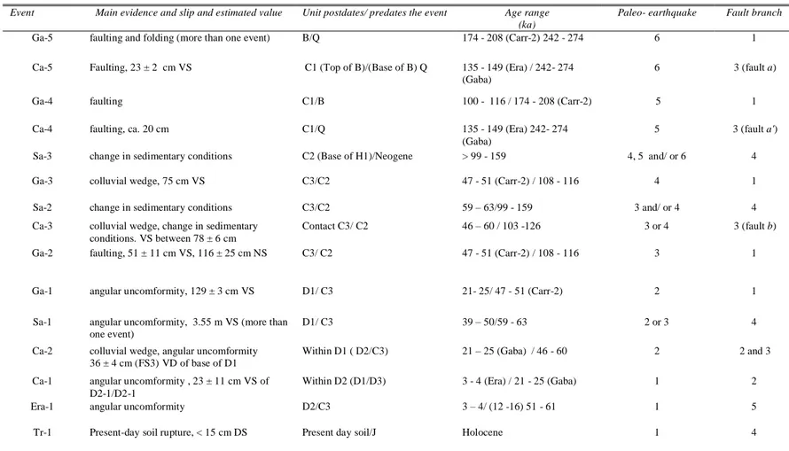
them possibly corresponding to the same earthquake observed at different trenches. 396
17 The identification of the events was based on 1) the fault displacement of the Present 397
day soil, 2) the sealing of a fault by a younger unit, 3) the displacement of a fault by 398
another fault, 4) the angular unconformity between two adjacent units, 5) a sudden 399
change in the sedimentary conditions due to a possible tectonic origin and 6) the 400
formation of a colluvial wedge interpreted as the collapse of a fault scarp. 401
The time range of each event was determined by using the ages of the postdating and 402
predating units at its trench (Table 3). At some cases, those ages were not available. 403
Then, we used the age for those units at the closest trenches. 404
405
5.1 Carrascos site (strands 2 and 3)
406
Carrascos corresponds to the area where the AMF changes from a single trace to a
407
splay of different fault strands. Two trenches separated by ca. 80 m were studied at 408
this site: Carrascos-1 to the NE, and Carrascos-2 to the SW (Figs. 2, 3a, 6a, b and c). 409
The activity of the faults has led to the formation of several hills blocking the alluvial 410
sediments of the small creeks to the SE of Carrascos creek. 411
Three depositional phases are observed at Carrascos-1: an older phase (G5) 412
represented by unit B, an intermediate phase (G4 and G3) consisting of units C1 to C3, 413
and a younger phase (G2) made up of units D1 and D2. These alluvial deposits are 414
overlain by a soil unit. 415
With the exception of the upper part of D1, all units are faulted and/or folded. 416
Four faults are exposed at the trench. The north-western fault corresponds to the Góñar 417
FS2, which dips ca.15º to the SE and displaces unit C and the base of D1 (Fig. 6b). The 418
other three faults correspond to FS3, and are termed fault a, a’, and fault b. Fault a is 419
vertical and faults a’ and b dip 45º and 40º to the SE, respectively. Faults a’, b and FS2 420
have a fault-propagation fold associated with each of them. The degree of folding is 421
18 greater for the oldest units. Units D1 and D2 are gently folded. Only fault a’ displaces 422
all the units. Adjacent to the faults, the clasts within the different beds are progressively 423
rotated and the beds of units B and C1 are stretched. Gouge is solely associated with 424
fault a, which is less than 20 cm thick. Faults a’ and b match the axial plane of the fold 425
without a well defined fault plane. The dips of these faults suggest that they merge at 426
depth; faults a and b probably intersect at less than 10 m below the surface, and FS2 and 427
FS3, a few meters below this intersection. 428
At Carrascos-2, only units B and C and fault 2 are exposed. The units are
429
dragged and folded by FS2, which dips 55 º to the SE and is continuous up to the 430
present-day surface. The fault is associated with an asymmetric anticline (affecting 431
unit B) in the upthrown block and a recumbent syncline (affecting units C2 and C3) in 432
the downthrown block (Figs. 4 and 6c). The fault is characterized by a white fault 433
gouge that is a few millimeters thick. Subhorizontal open fractures affect unit C1 next 434
to the fault, indicating the existence of subhorizonal compressional stress orthogonal 435 to the fault. 436 437 Paleoseismic events 438
Five events were identified at Carrascos-1, Ca-1 to Ca-5 from youngest to oldest. 439
The youngest event, Ca-1, was associated with FS2. This event displaces the base of 440
unit D2 (D2-1) but not the top (D2-2). The vertical displacement associated with this 441
event is 23 ± 11 cm. The only age constraint of this event is the age of unit D1 at the 442
Gabarrones trench, 21 - 25 ka TL, and the age of unit D3 at Era, 3.25- 3.89 ka TL.
443
Event Ca-2 occurred on FS2 and FS3. Near FS2, the base of unit D1 and the 444
previous units are more folded than the upper part of unit D1 and the subsequent units. 445
The event occurred shortly after the deposition of the base of D1 and does not affect 446
19 its upper part. At this fault, this event produced a vertical displacement of 36 ± 4 cm. 447
At fault b (FS3), a deformation event led to the tilting of C3 and the underlying units, 448
whereas D1 unit overlying fault b was not deformed. The horizon of this event next to 449
fault b was placed below a colluvial unit interpreted as a tectonic colluvial wedge. 450
Both events were considered as the same event (Ca-2) because the base of unit D1 451
(deformed by FS3 during this event) was probably not deposited next to FS2 or was 452
removed by erosion after the earthquake. The accumulated vertical slip of these events 453
at the base of D1 is 60 ± 9 cm. Thus, this event would be bracketed by units C3 and 454
the middle part of D1. We selected the age of D1 at the Gabarrones site (21 - 25 ka 455
TL at Gabarrones), and not the age of D2 at the Era site (12 – 16 ka pIRIR at Era) as 456
the post-dating age since the former is likely to be closer to the time of faulting than 457
the latter. Summarizing, the age of Event Ca-2 can be constrained by C3 (46 – 60 ka 458
pIRIR) and D1 (21 - 25 ka TL at Gabarrones). 459
Ca-3 is defined by a colluvial wedge formed next to fault b. This colluvial
460
wedge is made of clasts derived from unit C2, which was probably uplifted and 461
removed by erosion in the upthrown block. Additional evidence in support of Ca-3 is 462
the intense red color (enhanced precipitation of ferrous minerals) at the base of unit C3 463
near the fault zone (Fig. 4g). This feature is interpreted as resulting from the formation 464
of an ephemeral pond at the toe of the scarp, possibly related to the obstruction of the 465
drainage caused by the co-seismic growth of the scarp. 466
The displacement associated with event Ca-3 is ca. 78 ± 6 cm. According to the 467
relationships proposed by McCalpin (1996), the vertical displacement associated with 468
one event is approximately twice the maximum thickness of a fault derived colluvial 469
wedge associated with it, in this case 39 ± 3 cm. Such a relationship is based on direct 470
observations made on present-day fault ruptures (McCalpin, 1996) and is based on the 471
20 fact that the co-seismic colluvial wedges are made of clasts derived from the rapid 472
degradation of the fault scarp after the earthquakes so that their maximum thickness 473
(i.e., the thickness next to the fault) is ca. a half of the original height of the scarp 474
before its collapse. 475
Another estimation of the vertical slip can be obtained from the displacement 476
of the base of C3 unit, 27 ± 5 cm. These slip values are a minimum estimate of the 477
total slip associated with such an event because it is an estimate of the vertical 478
displacement and only corresponds to one of the fault strands of the system. This event 479
occurred before the deposition of unit C3 (46 – 60 ka TL) and after a period of reduced 480
sedimentation postdating unit C2 (103 -126 ka TL). This is corroborated by a calcrete 481
layer on top of this unit and below the colluvial wedge. 482
Event horizon of Ca-4 was located within subunit B2, whose upper part was 483
not affected by fault a’. Movement along fault a‟ displaced fault a and the beds in 484
subunit B1. Event Ca-5 is indicated by faulting of subunit B1 and the basal part of B2. 485
The envelope surface of the B1/ B2 contact and of layers within B2 is displaced 486
vertically by 117 ± 8 cm. Given that this displacement is likely to be the result of at 487
least 4 events, a mean value of 23 ± 2 cm per event is obtained. It was not possible to 488
correlate the layers of unit B dated at Carrascos-2 and the layers of unit B exposed at 489
Carrascos-1. The age of these two events can only be constrained as predating unit C1
490
(at the Era trench, 149 – 135 ka pIRIR) and postdating the unit before unit B, unit Q at 491
Gabarrones (274 – 242 ka pIRIR).
492
Events from Ca-1 to Ca-5 cannot be well constrained by the deformation of the 493
units exposed at Carrascos-2, where FS2 is exposed. Although the fault at this trench 494
extends up to the Present-day surface, no clear offset of the soil is observed. The 495
propagation of the fault plane into the soil could be due to an event more recent than 496
21 Ca-1. However, it could also be apparent and could result from an irregular 497
development of the soil over the fault zone. Since such a hypothetical event is not 498
observed at Carrascos-1, 80 m to the west, we did not to interpret this feature as a real 499
faulting of the soil. Consequently, all the events may have contributed to the formation 500
of the drag fold observed at Carrascos-2, although they cannot be well constrained. 501
502
5.2 Gabarrones site (strand 1)
503
The Gabarrones geomorphological setting bears a strong resemblance to that of 504
Carrascos-2. Here, the presence of a lighter colored topographic high on G6, delimits
505
the front of alluvial fan G2 (Fig. 2). A trench was excavated perpendicular to this 506
linear boundary between units G6 and G2, revealing the Góñar FS1. This fault strand 507
is also exposed at the El Asno creek with a 020-025/70º SE trend (slickenlines with 20º 508
S pitch). It has an associated shear zone affecting a well cemented conglomerate that is 509
probably of Middle Pleistocene age. 510
The deposits of alluvial fan phases (Fig. 6d) are folded and faulted in such a 511
way that 1) the beds of unit Q dip ca.70º SE, 2) intermediate units (B, C1 and C2) are 512
less folded and faulted, and 3) the youngest units are slightly deformed (C3) or 513
undeformed (D1 and soil unit). The structure revealed at the trench corresponds to an 514
asymmetric syncline with a faulted sub-vertical southeastern limb (Fig. 6d). All the 515
faults in this limb merge at depth into a vertical fault (fault a) that represents the 516
southeastern boundary of the fault zone. The overall structure is interpreted as a tilted 517
push-up structure. This is supported by a lensoidal-shape defined by the faults in the 518
NE wall of the trench. Fault b has an orientation of 087º/25ºS. The slickenlines on its 519
plane have a pitch of 70ºW, indicating oblique reverse and left-lateral movement (Fig. 520
4j).
22 522
Paleoseismic events
523
Evidence for five events, Ga-1 to Ga-5 from youngest to oldest was found at this site. 524
The youngest event (Ga-1) tilted the synclinal structure to the NW, slightly folding 525
unit C3. This is evidenced by the geometry of the internal layering of C3, which dips 526
slightly to the SE and runs parallel to the contact between C3 and C2 except near the 527
fault zone, where it dips to the NW. Since C3 is an alluvial unit with a NE provenance, 528
the dip of its layers towards the NE is not expected to be a sedimentological feature. A 529
minimum of 129 ± 3 cm of vertical slip was inferred for this event by considering the 530
offset of the base of C3, which is observed in the downthrown block and can be set to 531
below the present day soil in the upthrown block. Tilting is likely to be tectonic and 532
cannot be ascribed to fault b, as unit C3 is not broken. The fault producing this tilting 533
could either belong to the group of faults located to the SE or could be another fault 534
not exposed at this trench and located more to the SE. This event occurred after the 535
deposition of C3 (47 – 51 ka pIRIR at Carrascos-2) and before unit D1 (21 - 25 ka 536
pIRIR). 537
The previous event, Ga-2, was caused by fault b, which cut the colluvial 538
wedge. The contact between the colluvial wedge and the over-riding block is a fault. 539
The uplifted part of the colluvial wedge was probably eroded away before the 540
deposition of C3 unit, which is expected since the top of the fault scarp would be made 541
of it. 542
The colluvial wedge consists of angular clasts derived from units C1 and B and 543
was formed during an earlier event, Ga-3. Using the McCalpin (1996) estimates of 544
displacement based on colluvial wedge thickness, we obtained a minimum vertical slip 545
of 75 cm for event Ga-3. The Ga-2 and Ga-3 events occurred after the deposition of 546
23 C2 (108 - 116 ka pIRIR ago) and before the deposition of C3 (47 - 51 ka pIRIR ago at 547
Carrascos-2). The ages obtained at these trenches do not allow us to distinguish a
548
different time constraint for these events. 549
The dip displacement of the Q-B contact along fault b is 103 ± 22 cm. This slip 550
probably results from at least two events, one producing the colluvial wedge and a 551
successive one displacing it. Then, a 51 ± 11 cm of dip displacement is attributed to 552
each of the events Ga-2 and Ga-3. A 116 ± 25 cm net slip per event was calculated 553
using the aforementioned measure and the orientation of the slickenlines of the fault. 554
Events Ga-4 and Ga-5 are related to the movement along fault a and along the group 555
of faults that merge into it. Event Ga-4 displaced unit B (174- 208 ka pIRIR at 556
Carrascos-2) but not unit C1 (100 -116 ka pIRIR) so that an event horizon was placed
557
at the base of unit C1. Event Ga-5 corresponds to the angular unconformity between 558
units Q and B. Layers in unit Q dip steeply to the SE with the result that more than one 559
event probably occurred between their formation (before 258 – 274 ka pIRIR) and the 560
deposition of unit B. 561
562
5.3 Tio Rey site (branch 3)
563
The Tio Rey site was chosen for excavation because of the anti-slope inflexion of the 564
alluvial fan surface that favors sediment trapping. The precise location of the faults in 565
the neighboring El Asno and Los Yesos creeks helped to locate the trench (Fig. 2). The 566
faults in the creek are oriented 060º/70º SE and have affected the Neogene marls and 567
the overlying Quaternary alluvial fans. 568
The Tio Rey trench only exposes the deposits of alluvial phase G6 (units P and 569
J in the trench log; Fig. 6). The units within the alluvial fan are part of a train of 570
synforms and antiforms affecting units P and J. In most of the trench, the layers do not 571
24 show their natural slope but are tilted towards the NW, i.e. facing uphill. These folds 572
have been cut by a series of reverse faults, most of them dipping SE (e.g.: a, oriented 573
058º/35 and b, oriented 060º/35SE) and one dipping NW (fault c; oriented 574
030º/45ºNW). Fault b has slickenlines with a pitch of 80º W, indicating a reverse left 575
lateral component. The faults have discrete fault gouges consisting of well cemented 576
white silt. All the faults exposed at the trench are probably secondary faults associated 577
with the main faults observed at the El Asno creek. 578
We calculated the long term net slip accommodated by the exposed faults. To 579
this end, we undertook a microtopographic profile of the folded surface of alluvial fan 580
G6. The profile was perpendicular to the trace of FS4 and contained the trench (inset 581
of Fig. 6e). The base of unit J near the reference point X dips 7 º to the SE, as in the 582
microtopographic profile in the NW sector. By extrapolating the Present-day surface 583
of G6 to the trench, we obtained a minimum vertical displacement of 3.24 ± 0.36 m of 584
unit J. This value is equivalent to the vertical displacement of 3.26 ± 0.36 m of this 585
unit associated with fault b, which corresponds to a dip slip of 6.72 ± 0.74 m. (Fig. 586 6d). 587 588 Paleoseismic events 589
We were only able to constrain one event at the Tio Rey trench, event Tr-1. The 590
movement along fault b has a major vertical component, as inferred from the 591
slickenlines and from the vertical offset of the units. This fault extends towards the 592
surface, and displaces the top soil unit by ca. 15 cm along the dip(Fig. 4f). Thus, an
593
event horizon was placed at the top of the soil unit (Tr-1). The age of this event is 594
uncertain. Given that the area is affected by natural erosion and by plowing, it is 595
debatable whether the soil affected by the fault is a modern one. A tentative Holocene 596
25 age has been assigned to event Tr-1 in accordance with the degree of soil 597
development. 598
A total offset of 6.72 ± 0.74 m along the dip on this fault suggests the 599
occurrence of some earlier earthquakes, identified as Tr-X, after the deposition of unit 600
P, i.e. after 290 ± 13 ka pIRIR. 601
602
5.4 Sardinas site (branch 4)
603
Sardinas trench is located at Góñar (Fig. 2, Fig.6f), on the trace of FS4. The site
604
corresponds to an asymmetric hill, with a maximum height of ca. 3 m on the steepest, 605
NW facing side. The exposure at this trench showed that the Neogene basement is 606
uplifted, blocking alluvial fans G3 and G2 sourced from the Las Estancias range. 607
During the deposition of G3, the alluvial fan overran the scarp as indicated by the 608
preservation of the G3 alluvial deposits (unit C3) at the top of the hill (Fig.6f). 609
The Neogene sequence at this site consists of an alternation of conglomeratic 610
beds (with rounded clasts) and marls dipping 80º SE. Units H to C3 dip to the NW, 611
and uncomformably overlie the basement. Units H1 and H2 consist of clasts embedded 612
in a pale silty matrix. The color and lithology of units H1 and H2 indicate that they are 613
derived from the Neogene basement exposed in the upper part of the trench. Units H1 614
and H2 are interpreted as colluvial units generated by the degradation of the Sardinas 615
scarp. Clast imbrications and lithology of alluvial units C2, C3 and D1 confirm that 616
they are sourced from the Las Estancias range. 617
FS4 consists of at least two fault strands, fault a and “inferred fault b”. The 618
Neogene sequence is affected by a 40 - 50 cm thick fault zone, i.e. fault a, which is 619
oriented 045/75º SE and is parallel to the bedding. The fault gouge is characterized by 620
c-s structures indicating a dominant reverse movement with a minor left lateral 621
26 component. Deformation along fault a could have contributed to the progressive uplift 622
of the Sardinas hill in the past, but it did not affect the overlying deposits (unit H and 623
soil). Its location and orientation do not account for the folding of the overlying units 624
(H1 to C3), which must have been generated by movement along an inferred fault, 625
fault b. Deformation of the layers in the foot wall of fault a is expressed as an open 626
fold with the axial plane dipping to the SE and probably coincident with the inferred 627
fault b. Strong tilting of the layers to the NW is observed. The 10º dip in the central 628
part of the trench increases to 35º in the northwestern part. The uppermost unit, D1, is 629
the only non-deformed unit. The 6º dip of the layers to the SE is probably depositional 630
since it is coincident with the general slope of alluvial fan G2 obtained through 631
microtopography. The top of this unit has been transformed by plowing. 632
633
Paleoseismic events
634
Evidence of at least three paleoearthquakes was obtained at this site, Sa-1 to Sa-3 from 635
youngest to oldest. The youngest event observed, Sa-1, is defined by an angular 636
unconformity located at the base of unit D1‟. This event also caused the uplift of part 637
of unit C3 located at the top of the hill. To estimate the minimum vertical offset 638
associated with this event, we assumed that the original surface of alluvial fan G3 had 639
the same slope as the surface of the undeformed alluvial fan G2, i.e. 6º to the SE. 640
Then, we restored the folding affecting unit C3 (alluvial fan G3) in the northwestern 641
block and projected its base underneath unit C3 in the southeastern block (Fig. 6f). 642
This projection suggests a minimum vertical displacement of 3.55 ± 0.39 m for the 643
base of C3. The age of this event is constrained by unit D1‟ (39 - 50 ka TL) and unit 644
C3 (59 - 63 ka pIRIR). Event Sa-1 probably corresponds to several events, as 645
suggested by the anomalously large throw of 3.55 m associated with it. 646
27 The identification of events Sa-2 and Sa-3 is based on the change in 647
sedimentary environment represented by the base of units H1 and H2, respectively. In 648
each of these earthquakes, the Sardinas hill would have been uplifted and the newly 649
exposed basement rock would have been rapidly eroded and deposited at the foot of 650
the scarp. The high erodability of the basement rocks suggests that the colluvial layers 651
(H1 and H2) were formed in a relatively short period after two events. Alluvial 652
sediments (C2) were deposited between this rapid sedimentation associated with H1 653
and H2. Thus, event Sa-2 should have occurred between units C2 and C3, i.e. between 654
59 ka and 159 ka TL. Event Sa-3 occurred before the deposition of C2 (99 -159 Ka 655
TL) so that a 99 ka TL age is considered as a minimum age for it 656
We did not consider the ages obtained for the H1 colluvial deposit since the distance 657
from the source was insufficient to ensure the total bleaching of the grains used for the 658
luminescence dating. 659
660
5.6 Era site (branch 4)
661
The Era site is located at Góñar, next to the head of a highly entrenched active creek 662
that provides a good exposure of the fault (site 6 in Fig. 2a and Fig. 4e). At the 663
surface, this site shows a gentle step of ca. 1 m, separating orchards (in the 664
downthrown block) from an abandoned threshing floor (in the upthrown block). In the 665
northwestern margin of the creek, the Góñar FS4 can be deduced from the sharp 666
contact between vertical Neogene marl in the hanging block and late Quaternary 667
alluvial deposits in the downthrown block. Another natural exposure of this fault can 668
be observed at site 1 (Fig. 2), where the layers of the alluvial fan G3 are folded and 669
thrusted 0.5 m to the NW. The fault is oriented 055º/50º SE in the natural outcrop and 670
060º/25º SE at the trench. 671
28 Two faults are observed along the axial planes of the folds affecting the units 672
in the Era trench (Fig. 6g). Alluvial fan G5 (unit B2) is overlain by alluvial fan G3 673
(unit C1), both being folded and thrusted towards the N-NW over alluvial fans G3 674
(unit C1 to 3) and G2 (units D2 and D3). This deformation caused an antiformal fold 675
in the over-thrusting block and a synformal fold in the downthrown block. The faults 676
exposed are more easily identified in the units with a well cemented matrix (as the 677
upper part of C1 and C2), where discrete fault planes can be observed. However, in the 678
units that are clast supported, the fault can only be inferred from the alignment of the 679
clasts. Small offsets of ca.10 cm were observed within unit C1 and at the C1-C2 680
contact. The overall structure bears a strong resemblance to that exposed at Carrascos 681
1 and 2 trenches (Fig. 6a). A vertical displacement of 4.68 m associated with this fault 682
was estimated by considering the C1-B contact in the upthrown block and its estimated 683
depth at the downthrown block. The contact was drawn taking into account the 684
maximum thickness of C1 observed underneath the fault (Fig. 6g). This is a minimum 685
estimate of the vertical slip since the base of unit C1 is probably located at a lower 686 position. 687 688 Paleoseismic events 689
At this trench, it was possible to constrain only one event, Era-1, at the top of unit C3. 690
Unit C3 is folded in contrast to unit D3, suggesting that the event occurred after C3 (at 691
this trench, 55 – 61 ka pIRIR) and before the deposition of unit D3 (3.25 – 3.89 ka 692
TL). Since it was not possible to ascertain whether D2 was deformed, it is debatable 693
whether this event occurred before the deposition of unit D2. However, the fact that 694
D2 was not preserved on the hanging block suggests that unit D2 was uplifted during 695
event Era-1 and was subsequently eroded away. We used the age of C3 as the 696
29 maximum age for this event, although it should be borne in mind that this event could 697
be younger than D2. The top of C3 is therefore considered to be the paleosurface after 698
this event (Fig. 6g). 699
700
6. Discussion
701
In this section, the timing of the events obtained for the six paleoseismologic 702
trenches is compared to obtain the correlation of the events, i.e. the common event 703
chronologies that could account for the deformation at the different sites. The slip rates 704
derived from the trench analysis are also discussed. The results are compared with the 705
event chronologies and slip rates of the neighboring paleosesimological sites studied 706
by other authors. This comparison allows us to evaluate the maximum fault rupture 707
inferred from the correlation of the events, and to provide some estimates of the 708
maximum magnitude expected in the region. Finally, some geodynamical implications 709
are discussed at the end of the section. 710
711
6.1 Correlation among the paleo-seismic events at the Goñar faults
712
We used the term “paleoearthquake” (abbreviated to PE) for the paleoseismic events 713
derived from the correlation between different trenches while the term “events” is 714
restricted to those identified by a single trench analysis (e.g., Ca-1, etc.). The summary 715
of the age constraints and slips associated with all the events is provided in table 3. 716
The correspondence between each event and the common PE is given in this table. The 717
PEs are listed 1 to 6, from youngest to oldest. 718
A minimum of 6 PEs were inferred. This is a minimum estimate of the PEs 719
recorded at the trenches since we cannot be sure whether all the earthquakes were 720
recorded. In the oldest units, the deformation attributed to a single event is possibly the 721