© Author(s) 2018. This work is distributed under the Creative Commons Attribution 4.0 License.
The seismogenic fault system of the 2017 M
w
7.3 Iran–Iraq
earthquake: constraints from surface and subsurface data,
cross-section balancing, and restoration
Stefano Tavani1, Mariano Parente1, Francesco Puzone1, Amerigo Corradetti1, Gholamreza Gharabeigli2,
Mehdi Valinejad2, Davoud Morsalnejad2, and Stefano Mazzoli1 1DISTAR, Università degli Studi di Napoli “Federico II”, Naples, Italy 2N.I.O.C., Tehran, Iran
Correspondence: Stefano Tavani ([email protected]) Received: 8 March 2018 – Discussion started: 19 March 2018
Revised: 4 June 2018 – Accepted: 12 June 2018 – Published: 20 June 2018
Abstract. The 2017 Mw7.3 Iran–Iraq earthquake occurred
in a region where the pattern of major plate convergence is well constrained, but limited information is available on the seismogenic structures. Geological observations, interpreta-tion of seismic reflecinterpreta-tion profiles, and well data are used in this paper to build a regional, balanced cross section that pro-vides a comprehensive picture of the geometry and dimen-sional parameters of active faults in the hypocentral area. Our results indicate (i) the coexistence of thin- and thick-skinned thrusting, (ii) the reactivation of inherited structures, and (iii) the occurrence of weak units promoting heteroge-neous deformation within the palaeo-Cenozoic sedimentary cover and partial decoupling from the underlying basement. According to our study, the main shock of the November 2017 seismic sequence is located within the basement, along the low-angle Mountain Front Fault. Aftershocks unzipped the up-dip portion of the same fault. This merges with a de-tachment level located at the base of the Paleozoic succes-sion, to form a crustal-scale fault-bend anticline. Size and geometry of the Mountain Front Fault are consistent with a down-dip rupture width of 30 km, which is required for an Mw7.3 earthquake.
1 Introduction
On 12 November 2017, a Mw 7.3 earthquake struck the
northwestern portion of the Lurestan region of the Zagros Belt, at the boundary region between Iran and Iraq (Fig. 1).
This earthquake had a thrust fault plane solution with a 351 striking and 16 dipping nodal plane. The other nodal plane has a strike of 122 and a dip of 79 . The P axis plunges 33 toward 223 , whereas the T axis plunges 54 toward 18 (Fig. 1) (source: USGS, https://earthquake.usgs.gov; last ac-cess: 18 June 2018). These parameters indicate SW-directed co-seismic slip along a low-angle thrust, such a direction being nearly perpendicular to the strike of the Zagros Belt and of its main thrust systems. The hypocentre is located at a depth of ca. 20 km where, according to preliminary tele-seismic data, the slip was nearly 9 m (Utkucu, 2017). Coher-ently with SW-directed motion along a gCoher-ently dipping thrust, interferometric synthetic aperture radar (SAR) data show a NW–SE to NNW–SSE-elongated displacement field (Fig. 2). Consistently, the maximum surface deformation (reaching ca. 90 cm of uplift; Kobayashi et al., 2018) is shifted some tens of kilometres southwestward of the epicentre of the main shock. Forty-five Mw > 4 aftershocks followed during the
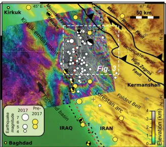
next 30 days in a N–S-elongated, 50 km ⇥ 150 km area lo-cated to the west of the main shock (Fig. 2). Aftershocks lined up along the Mountain Front Flexure (Figs. 1, 2), as most of the major earthquakes of the last 50 years (Berberian, 1995; Talebian and Jackson, 2004) have been, a major tec-tonic lineament of the area. However, the instrumental seis-mic record indicates that this structure had never produced a Mw> 7 earthquake in the last decades. Identifying the fault or
fault segment activated during the seismic event and defining its dimensional parameters are thus essential for the assess-ment of the seismic hazard (Wells and Coppersmith, 1994).
!""#$% 30° N 35° N 35° N 40° N 40° E 45° E45° E 50° E 50° E 55° E55° E 60° E60° E &'( '( )'*+& ,-*'( ./0 ./0 .12 .1 2 .00 .00 310 31 0 0,45#6
MRF = Main Recent Fault MZT = Main Zagros Thrust HZF = High Zagros Fault MFF = Mountain Front Flexure
!#$% 7#$% 8#$% 6#$% 9#$% "#$% :;< =' >,?( Kirku k emba yment Lurestan arc Dezful emba yment ! "
Figure 1. Tectonic sketch map of the Zagros Mountains, showing
epicentre and moment tensor of the 12 November 2017 Mw 7.3
earthquake (source: USGS, https://earthquake.usgs.gov/).
!"#$%& Mount ain Front Flexure '"#(%)*# +,-!*. /0 Main Recent Fault
!"#$%"% &'()*) &+(,"-.$"$ !<= & !:= & "< = > "! = > ! " # $ % &'()*+ ,-./ 0123 /012 /013 !" #$% &'( )*&+,' !"%($()-$% . Imbricat e zone !"#$% &'()'#* +,#-"-)$. /'0.$( & 50 km
Main Recent Fault Main Recent Fault
&*4+ 56 7*1(/ 2*8., +79( :; < ! !"#$%& !"#$%& 1234 5#$6 1234
Figure 2. Elevation map (source: ESDIS) showing the main struc-tural features of the Lurestan region and earthquake
distribu-tion (source: USGS, https://earthquake.usgs.gov/). Mw>4
earth-quakes of the November 2017 sequence are reported in white;
pre-2017 Mw>5 earthquakes are reported in yellow. The
Sen-tinel 1 co-seismic interferogram (11 November, 15:00 UTC to 17 November 2017, 14:59 UTC; http://sarviews-hazards.alaska.edu/ Event/34/; last access: 18 June 2018) is also shown as an overlay.
In seismically active fold and thrust belts (FTBs), where the earthquake dataset is not sufficiently robust to constrain the geometry of active faults, deep cross sections built us-ing balancus-ing techniques (Dahlstrom, 1969; Hossack, 1979) have been successfully used to improve the knowledge of the seismogenic structures, as carried out in, e.g., the Los Ange-les area (Shaw and Suppe, 1996; Davis et al., 1989), Taiwan (Yue et al., 2005; Mouthereau and Lacombe, 2006), and the
Longmen Shan FTB (Wang et al., 2013). In the Zagros FTB, many of the largest earthquakes are associated with major reverse faults affecting the Precambrian basement (e.g. Jack-son, 1980; Berberian, 1995; Talebian and JackJack-son, 2004), which are included in almost all the published balanced cross sections across the belt (Blanc et al., 2003; Molinaro et al., 2005; Mouthereau et al., 2007; Vergés et al., 2011). Despite being located more than 200 km away from the epicentral area, these cross sections suggest that the seismogenic struc-ture of the Mw7.3 earthquake could be related to the
Moun-tain Front Flexure, which extends across the aftershock area of the November 2017 earthquake (Figs. 1, 2). The flex-ure, across which a marked variation of both topography and structural relief occurs (Falcon, 1961), is commonly inter-preted as produced by a large underlying basement thrust, namely the Mountain Front Fault. This structure is thus a candidate for the seismogenic fault of the recent Mw 7.3
earthquake.
Geological observations of faults and folds affecting Meso–Cenozoic rocks exposed in the epicentral area are reported in this study. These observations were integrated with the interpretation of near-vertical seismic reflection pro-files calibrated with well logs, allowing us to produce a de-tailed and well-constrained geological cross section reach-ing a depth rangreach-ing from 2 to 5 km. The section was then completed at depth by using the balancing technique (e.g. Dahlstrom, 1969; Hossack, 1979). Our results indicate that the November 2017 seismic activity is attributable to the Mountain Front Fault, for which, using the balancing tech-nique, we reconstructed 10 km of cumulative displacement in the hypocentral area.
2 Geological background
The NW–SE-striking Zagros mountain belt formed due to the continental collision between the Arabian and Eurasian plates (Berberian and King, 1981; Alavi, 1994, 2007; Ar-gand et al., 2005; Mouthereau et al., 2006; Vergés et al., 2011). The present-day northward motion of Arabia relative to fixed Eurasia is about 2 cm yr 1 (Vernant et al., 2004).
This is partitioned between right-lateral motion along NE– SW-striking faults and NE–SW-oriented shortening (Blanc et al., 2003; Vernant et al., 2004; Talebian and Jackson, 2002, 2004), which in the Zagros belt is about 5–10 mm yr 1
(Ver-nant et al., 2004). The belt is bounded to the NE by the Main Recent Fault and Main Zagros Thrust (Fig. 1), forming the suture zone that separates terrains derived from the Meso-zoic conjugate margins of the Neo-Tethyan Ocean. The Za-gros FTB, to the SW of the suture, involves units originally pertaining to the Arabian continental margin (Ziegler, 2001; Blanc et al., 2003; Sepehr and Cosgrove, 2004; Ghasemi and Talbot, 2006; Mouthereau et al., 2012; English et al., 2015). Within the Zagros FTB, the High Zagros Fault, a ma-jor structure striking NW–SE, separates the imbricate zone
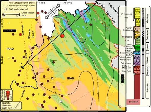
!"#$% &# !"# $$% &' !(# ("% &' ()#$$%&* ("#("%&* '()* 10 km +,,-. /012-2 30,-456-. /012-230,-!"# $%&'()* +, -) '()+
High Zagros Fault
,-%. /01 . !&-./ 2 30.0 41. !0 %"/56 !"# "$ !"# "$ !%# $ !&#'$ !%# $ *7.6 89 57:-;7<,= 652- >) " ( ?7<,-6=@ A7B-;-,6& 2-C68&D:;E !&#'$ '-7.FG-.6=@71&B-=B;=@&C.0/=1-4HI&-JC10.76=G-&K-11
Seismic profile in Figs. 4 and 5
. ./ L.0BB&B-@6=0, 6.7@-. ./ !"# $%&'()* +, -) !"# $%&'()* +, -) 1 km I-1=&M87,7 M5..7&L8=,-N7156=&O871-BO7.:= O-8:7,=P7,OF'FN I7.75 O7.G7:+17; QB;7.= L8=7&R7=.= N-25&H ?=.<7&?=. 0$% '11% & 23 4), 5)-) 6$)('&3 7' 8) ,5) -) 7)$"% '-O878A737, 7' 8) ,+ ,%& ()*+,+-. S,2&/0.-2--C =,/=11 TB6&/0.-2--C =,/=11 L0;C-6-,6 ?0A=1
-Figure 3. Geological map of the NW portion of the Lurestan region (source: National Iranian Oil Company and original field mapping) showing (i) November 2017 earthquakes; (ii) traces of near-vertical seismic profiles and wells used to constrain the geological cross section of Fig. 6 (profiles shown in Figs. 4 and 5 are in black); (iii) magnetic basement depth (Teknik and Ghods, 2017), and (iv) a trace of the geological section in Figs. 4 and 5. The inset shows the stratigraphic succession of the area, with thicknesses for the Mesozoic to Cenozoic stratigraphic units computed from original field data. Thickness for the Paleozoic to Lower Triassic is taken from the literature on the geology of Iraq (Jassim and Goff, 2006). The supposed trace of the Khanaqin fault is from Lawa et al. (2013).
to the NE, where intensely faulted and folded units are ex-posed, from the Folded Belt to the SW (Blanc et al., 2003; Karim et al., 2011; Vergés et al., 2011). The SW bound-ary of the Zagros FTB is the Mountain Front Flexure, cor-responding to a basement and topographic step that divides the belt from its foreland basin to the SW (Falcon, 1961). The flexure is commonly interpreted as being underlined by a thick-skinned basement structure (e.g. Berberian, 1995; Blanc et al., 2003; Vergés et al., 2011), although many re-searchers have also proposed a thin-skinned geometry (Mc-Quarrie, 2004; Hinsch and Bretis, 2015). The flexure has a si-nusoidal shape, defining salients and recesses along the belt. The seismic sequence of the November 2017 earthquake is located at the boundary between two of them, namely the Kirk¯uk embayment and the Lurestan arc (Figs. 1, 2). Folds and thrusts of the Folded Belt of the Kirk¯uk embayment and of the Lurestan arc are NW–SE-striking, becoming lo-cally NNW–SSE-trending along the boundary between the two domains. There, a major bend of the Mountain Front Flexure occurs (Vergés et al., 2011; Sadeghi and Yassaghi, 2016; Koshnaw et al., 2017) (Figs. 2, 3). Indeed, the envelope of NNW–SSE-striking en échelon folds along the Mountain Front Flexure in the epicentral area of the November 2017
earthquake roughly runs N–S (Fig. 2). This is interpreted as being associated with the occurrence of a N–S-striking base-ment fault (i.e. the Khanaqin Fault; e.g. Berberian, 1995; Hessami et al., 2001; Lawa et al., 2013; Allen et al., 2013) that should currently act as a right-lateral fault. Folds in the Lurestan arc affect an about 10 km thick sedimentary suc-cession (Hessami et al., 2001; Ziegler, 2001; Homke et al., 2009; Vergés et al., 2011; English et al., 2015). In detail, the uppermost Proterozoic basement of the Arabian plate in the Lurestan region is overlain by a nearly 3000 m thick Pale-ozoic succession dominated by continental clastic deposits (Jassim and Goff, 2006; Bordenave, 2008). The strong rhe-ological contrast between the crystalline basement and the overlying sedimentary cover makes the basement–cover in-terface a major decollement horizon of the Lurestan region (e.g. Vergés et al., 2011), despite the lack of evidence for the occurrence of Hormuz salt at the base of the sedimentary pile of the study area. Permian rifting, related to the opening of the Neo-Tethys Ocean (Berberian and King, 1981; Sepehr and Cosgrove, 2004; Ghasemi and Talbot, 2006), led to the deposition of about 1 km of shallow-water carbonates (Chia Zairi Formation) (Jassim and Goff, 2006; Bordenave, 2008), with some tens of metres of shales at the base, forming a
mobile level sandwiched between two competent packages (Fig. 3). With continuing passive margin subsidence, nearly 1800 m of Triassic–Lower Jurassic shallow-marine carbon-ates and evaporites, with minor shales, accumulated (Mirga Mir to Sekhaniyan Formation) (Jassim and Goff, 2006; Bor-denave, 2008). This interval is essentially formed by compe-tent units, with the exception of the about 100 m thick Ba-luti and Bedu shale formations, at the top and base of the Triassic succession, respectively. This is a remarkable dif-ference with respect to the Fars and Dezful embayment ar-eas to the SE of the Zagros Belt, where the dolostones and limestones of the Triassic Kurra Chine Formation are substi-tuted by the evaporite-dominated Dashtak Formation, which acts as a major decollement level there. A major late Early to Middle Jurassic subsidence pulse led to carbonate plat-form drowning and deposition of about 100 m of relatively deep-water limestones, marls, and black shales and evapor-ites (Sargelu, Naokelekan, Barsarin Formation, Toarcian to Tithonian), followed by 700 m of Cretaceous basinal lime-stones, shales, and marls (Garau, Sarvak and Ilam forma-tions) (Jassim and Goff, 2006; Bordenave, 2008). The clo-sure of the Neo-Tethys Ocean during the Late Cretaceous led to the formation of a flexural basin, filled by a ca. 2 km thick Maastrichtian to Eocene succession (Hessami et al., 2001; Homke et al., 2009; Vergés et al., 2011; Saura et al., 2015), evolving from deep-marine marls and limestones to a pro-grading wedge of deep-marine to continental clastic sedi-ments. This first foredeep infill is overlain by about 500 m of shallow-water carbonates of the Shahbazan and Asmari Formation (Oligocene–lower Miocene), passing upward to lower Miocene evaporites. Renewed shortening and thrusting from the late Miocene to recent times led to the deposition of a younger foreland basin clastic infill (Fig. 3) (Hessami et al., 2001; Jassim and Goff, 2006; Homke et al., 2009).
3 NE–SW geological cross section
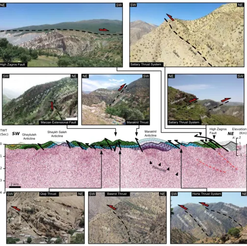
In this paragraph we present a NW–SE-oriented geological section across the study area. The section is divided into two portions. Figures 4 and 5 illustrate the NE and SW por-tion of the secpor-tion, respectively (with a small overlap area). Two seismic reflection profiles running at a low angle to the geological cross-section trace are projected onto the section plane, and key field observations along the NE portion of the section are also reported in Fig. 4.
The High Zagros Fault to the NE of the study area inter-sects the cross section of Fig. 4 in its northern portion. There, the major thrust fault dips roughly parallel to the strata of both hanging-wall and footwall blocks (i.e the cut-off angles are close to 0). Cretaceous strata in the footwall are affected by the NW–SE-striking, tens of kilometres long thrusts of the Satiary Thrust System. These thrusts have low (< 10 ) hanging-wall and footwall cut-off angles (Fig. 4). Along the section, the Garau Formation sits in the hanging wall of
the thrust and the Ilam Formation lies in its footwall. How-ever, the geological map of Fig. 3 shows that the Sehka-nian Formation is the oldest exposed unit in the hanging-wall block and that it is thrust on top of the Upper Cre-taceous Gurpi Formation (see also the field photograph of Fig. 4), which lies about 1000 m higher in the stratigraphic column. This feature, coupled with the observed relationship between hanging-wall flat and footwall flat, suggests dis-placements in the order of several kilometres. In the footwall of the Satiary Thrust System, Upper Triassic to Cretaceous strata are, as a whole, 20–30 NE-dipping for about 4 km, until they meet the tens of kilometres long Herta Thrust Sys-tem. This includes two 30 dipping thrusts (joining south-eastward; Fig. 3) showing very low cut-off angles and sep-arating the Triassic Sarki Formation in the hanging wall of the trailing thrust from the Sargelu and Garau formations in its footwall (Fig. 4). The repetition of hanging-wall flat on footwall flat geometries (Fig. 4) indicates a remarkable (i.e. several kilometres) displacement also for the Herta Thrust System.
Near-vertical reflection seismic profiles in this northern area are affected by significant noise; however, both the Satiary and the Herta thrust systems are imaged at depth (Fig. 4), displaying very low cut-off angles, which confirms their significant horizontal displacement. Folds associated with the Herta and Satiary thrust systems are truncated by the High Zagros Fault in the SE portion of the study area. This may be observed in the eastern portion of the geological map of Fig. 3 and, in more detail, in the photograph of Fig. 4, where the sub-horizontal High Zagros Fault truncates an an-ticline exposing the Gurpi Formation in the limbs and the Ilam Formation in the core. This observation constrains the relative timing of the development of these structures, point-ing to an out-of-sequence emplacement (or reactivation) of the High Zagros Fault, which post-dates the development of the Herta and Satiary fault systems. Moving to the southwest, the Marakhil Anticline exposes the Geli Khana Formation in its core, and the seismic profile indicates that the Paleozoic strata are folded as well. The Marakhil Fault, bounding the anticline to the SW, has a high (> 60 ) hanging-wall cut-off angle, typical of a reactivated (i.e. positively inverted) exten-sional fault (e.g. Sibson, 1985; Williams et al., 1989). To the NE, the fault flanks a roughly 5 km wide, gentle syncline af-fected by low-displacement (i.e. < 100 m) reverse faults with both low (e.g. the Qlaji Thrust) and high (e.g. the Bawrol Thrust) cut-off angles. In detail, similarly to the Marakhil Fault, the Bawrol Thrust has a hanging-wall cut-off angle typical of a positively inverted normal fault, the original ex-tensional activity of which post-dated the deposition of the Sehkaniyan Formation. Indeed, syn-kinematic thickening of the Sargelu, Naokelekan, and Barsarin formations (S-N-B in Fig. 4) observed across the Marzan extensional fault, as well as wedging of the same formations in the hanging wall of the Qlaji Thrust indicate that many of the previously illustrated inverted faults (affecting Triassic and Jurassic strata)
devel-!"#$%& '(%& !"#$%& '(%& !)*) +,-,.%/% 0 !"#$%& '(%& !)*) + !1 *2 !%/$' !1 *2 !%/3% $ .%/%0 !)*)+ 40//%,5#'&" !1 *2 !1 *2 !"#$%& '(%& !)*)+ !)*)+ !1 *2 !"#$%& '(%& !)*)+ !)*)+ !1 *2 !"#$%&'(%& !)*)+ .%/%0 !)*)+ !%6'%/(,7#/086,!(86"9 :"/6%,7#/086,!(86"9 +%;/<=,7#/086, >%/%$#'=,7#/086 >%/?%&,2@6"&8'<&%=,A%0=6 B=%C',7#/086, .%/%0 !1 *2 :'D#,E%D/<8,A%0=6 !1 *2 !%6'%/(,7#/086,!(86"9 !"#$%&'(%& !"#F .0/G' .0/G' H=%9 H=%9 .0/G' H=%9 .0/G' H=%9 .0/G' !" # " $ % $ " # & '(' )*+,-./+012345 )67-$897 .#"(60="# I&6'J='&" >%/%$#'= I&6'J='&" !#"($#,!%="# I&6'J='&" !" #$ :; :'D#,E%D/<8, A%0=6 <1/+4=43,
Figure 4. NE part of the NE–SW-oriented geological section across the hypocentral area, with field photographs illustrating the main structural features. A near-vertical seismic profile is displayed below the cross section (vertical scale is roughly equal to the horizontal scale).
!"#$ %&'"()**+",-./0 %&'"12+$3''0*"4+20&5&.6 %&'"7)*'. %&'"80-#+/.9+/ %&'":;$+*. <.==20"4+20&5&.6 >20?+@.&/ A#$B !"#$%&'#" ()%*+'*)# (,-.'#" ()%*+'*)# /*0*)-#" ()%*+'*)# CD E D ! !" #$ F ! D E G %H% A;B : /1&)%.*)2301)% 3'#4&0#
Figure 5. SW part of the NE–SW-oriented geological section across the hypocentral area. Near vertical seismic profiles are displayed below the cross section (vertical scale is roughly equal to the horizontal scale).
oped during a Middle Jurassic extensional pulse. The Sheykh Saleh Anticline is another major structure of this part of the Lurestan region. It separates an area to the SW, where the oldest rocks exposed in the cores of the anticlines (Ghey-tuleh, Azgaleh, and Miringeh anticlines) belong to the Upper
Cretaceous Ilam Formation, from an area to the NE where the oldest rocks exposed at the core of the anticlines belong to the Triassic Kurra Chine and Geli Khana formations (Fig. 3). The NE block has a structural relief of about 2 km. Despite the significant noise affecting the seismic section, the Ilam
and Sehkaniyan formations are clearly imaged in the subsur-face of the area SE of the Sheykh Saleh Anticline (Fig. 5). Both formations are made of carbonates and are capped by shales and marls of the Sargelu and Gurpi formations, respec-tively, this making their top strongly reflective and recognis-able. The first clear occurrence of the top Sehkaniyan reflec-tors is underneath the southwestern limb of the Gheytuleh Anticline, at about 1 s two-way time (TWT) (Fig. 5), entirely consistent with the dip and thickness of the overlying strati-graphic units. These Sehkaniyan reflectors are SW-dipping and become NE-dipping about 2 km to the SW, below the syncline flanking to the SW the Gheytuleh Anticline. This coherence between surface and subsurface geometries points to a roughly parallel folding of the entire package overlying the Sehkaniyan Formation. About 1 km to the SW, the top Ilam reflectors also become recognisable. Further to the SW, starting from the Azgaleh Anticline area, reflectors are cali-brated with well logs and exposures of the top Ilam Forma-tion. In this southwestern portion of the section, the envelope of the top of the Ilam and Sehkaniyan formations defines a 2–5 SW-dipping, regional-scale panel, with limited decou-pled deformation between the Mesozoic and Cenozoic units due to the occurrence of a weak package comprised between the stiff Ilam and Asmari formations. This shallow-dipping faulted and folded panel terminates at the Miringeh Anti-cline, which displays an unfaulted forelimb. There the strata of the entire Paleozoic to Cenozoic sedimentary succession are parallel and form a 10 km wide SW-dipping monocline. In more detail, below the Miringeh Anticline, a gentle un-conformity occurs between the middle and upper Paleozoic reflectors, evidencing the occurrence of middle Paleozoic de-formation. The above-mentioned monocline is bounded by two N–S-striking anticlines cored by the Asmari Formation; below them, a repetition of the Mesozoic reflectors is ob-served, which is produced by a back thrust. At the SW termi-nation of the seismic sections, the entire Paleozoic to Ceno-zoic sedimentary succession becomes horizontal and forms a large-scale syncline.
4 Balancing the cross section
The cross section shown in Figs. 4 and 5 is completed at depth by producing a geological solution (Fig. 6) in which line-length preservation during folding and thrusting is as-sumed (e.g. Dahlstrom, 1969; Hossack, 1979). The balanced cross section is built along a direction oriented 49 N, which is perpendicular to the trend of major folds and thrusts. These structures display negligible regional plunge along the sec-tion, which allows us to use a vertical plane to build the section. This also ensures the absence of remarkable out-of-plane motion and allows us to directly compute the thickness of the exposed Mesozoic and Cenozoic units along the sec-tion. The chosen section plane forms an angle of 17 with the 215 N striking and 78 dipping plane containing the P
and T axes of the of the 2017 Mw7.3 earthquake, thus
repre-senting a proper section to obtain insights on the seismogenic structures.
Some lateral thickness variations, in the order of some tens of metres, are observed for the package comprised between the Sargelu and Barsarin formations. The Sehkaniyan and Sarki formations also display lateral thickness variations of the same order of magnitude. In the Geli Khana and Kurra Chine formations we have not observed any kind of growth structure, and the parallelism between reflectors observed in the seismic line of Fig. 4 indicates that the thickness of these formations can be considered roughly constant. These obser-vations indicate that, as a whole, a constant thickness can be used for the almost 2 km thick package comprised between the base of the Geli Khana Formation and the base of the Ga-rau Formation. The overlying units are not continuously ex-posed in the northern part of the section and, because of that, they are not shown in the restoration. The Paleozoic units and the basement, for which only limited and discontinuous information is available, are modelled using 1 and 2 km thick layers, respectively. For the sake of simplicity, thickness vari-ations in upper Paleozoic units are first neglected and then reintroduced after cross-section balancing. This is because the adoption of constant thickness for the entire upper crust and of flexural slip folding allowed us to assume line-length preservation. Coherently, the restored cross section shows the cumulative length of Mesozoic, Paleozoic, and basement lay-ers. The trace of the faults in the restored section is obtained by smoothing the polyline built by connecting the restored cut-off points. This is done to avoid zigzag effects, and, in any case, smoothing is less than 0.5 % of the original cut-off point position.
Coherently with field observations, in our reconstruction, thrusts to the NE of the Marakhil Anticline are thin-skinned and have a displacement in the order of some kilometres. They splay off from a basal decollement located at the bot-tom of the Triassic sequence, namely within the Bedu Shale, sandwiched between the competent Chia Zairi and Geli Khana–Kurra Chine packages. The Marakhil Anticline, on the other hand, is a deeply rooted structure, associated with the Marakhil inverted normal fault, which is observed at the surface (Fig. 4). The simple shallow geometry of this large wavelength fold introduces a geometrical problem at depth, as two solutions can be applied to model the deeper portion of the anticline. In the first one, the inverted fault affects only the sedimentary cover, the core of the anticline is filled by ductile material and the underlying basement is not involved in faulting and folding. In the second solution, the inverted fault involves also the basement. The lack of a sufficiently thick ductile layer at the base of the Paleozoic sequence and the occurrence of a structural step across the Marakhil Anticline are more compatible with the second, basement-involved, solution. Following this structural model and keep-ing constant the line length of both basement and cover, we solved the geometry in the core of the anticline by assuming
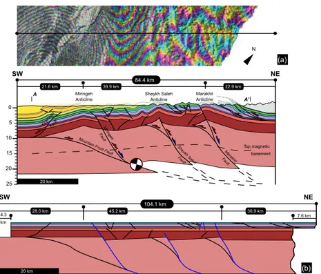
Top magnetic basement !" #" " !$ #$ $ 20 km ! !" 84.4 km %&'&()*+
,(-&./&(* 2+*31+420/*+,(-&./&(* %0'01+&/,(-&./&(*
104.1 km !#56417 8959 17 !!59417 4.3 km !:5"417 ;$5!417 7.6 km 8"59417 20 km !"#" $%&' (")'* +%,-$%. +"',% (")'* !&#& /0,% (")'* !1)/* "&/.(#1/* .(")'* 2%"/" 3&/ (")'* (a) (b) N !" #$ !" #$
Figure 6. (a) Balanced cross section along the direction of the geological section in Figs. 4 and 5, showing projected main shock and detail
of the co-seismic interferogram with a trace of the section.(b) Restored section.
the occurrence of a footwall shortcut of the inverted normal faults in the basement. This represents a typical feature as-sociated with the inversion of normal faults (e.g. McClay, 1989). In our solution, this shortcut transfers displacement from the main reactivated fault to the base of the sedimentary cover. Low-displacement, SW-verging reverse faults, and a major back thrust accommodate such a displacement in the Mesozoic and Paleozoic strata. The Sheykh Saleh Anticline to the SW shows a similar deep structure, which is even bet-ter supported by the remarkable structural step occurring at this location. Here, a positively inverted normal fault with a footwall shortcut occurs in the basement. The footwall short-cut transfers displacement from the main reactivated fault to the base of the sedimentary cover sequence. Such a displace-ment is accommodated by folding and faulting of the sedi-mentary cover, with the Paleozoic or Lower Triassic incom-petent units (i.e. the Bedu Shale Formation or the shaly level at the base of the Chia Zairi Formation) promoting decou-pling between Mesozoic and Paleozoic strata. In our interpre-tation, a positively inverted normal fault bounds the Miringeh Anticline to the NE too, producing the uplift of the crustal block in its hanging wall and preventing the southward prop-agation of the deformation of the sedimentary cover. Indeed, Paleozoic to Cenozoic strata in the crest and in the wide, ho-mogeneously dipping SE limb of this anticline are parallel, unfolded, and unfaulted. The lack of second-order faults and
folds to the SW of the Miringeh inverted fault and their oc-currence to the SW of the Marakhil and Sheykh Saleh faults, both the latter faults being characterised by a footwall short-cut, indicate that coupling between the basement and the sed-imentary cover is intimately linked with the shortcut devel-opment. The SW limb of the Miringeh anticline is underlain by a basement low-angle thrust, corresponding to the Moun-tain Front Fault, on which the main shock is located (Fig. 6). The focal mechanism provided by the USGS indicates a 351 striking and 16 dipping thrust fault, and its intersection with our 49 N striking vertical section gives 14 of apparent dip. Coherently, in our reconstruction the thrust dips 15 at the hypocentral depth and becomes almost sub-horizontal up-wards, where it reactivates the basement–cover interface. A back thrust splays from this upper flat, accommodating part of the displacement transferred from the main ramp of the Mountain Front Fault and forming a fishtail structure to-gether with it, responsible for the surface deformation ob-served from interferometric data. The position of such a back thrust roughly coincides with the Khanaqin Fault (e.g. Lawa et al., 2013) (Fig. 3), which accordingly must be downgraded to an accommodation structure of the Mountain Front Fault. An independent quality check of our reconstruction is pro-vided by the top of magnetic basement data (Fig. 6), com-puted according to the regional depth map in Teknik and Ghods (2017). The depths of the crystalline basement
un-derlying the sedimentary cover and the top of the magnetic basement obviously do not coincide, due to the heteroge-neous nature of the magnetic basement. However, their large-scale shape is similar, confirming the occurrence of highs and lows predicted by our reconstruction. The restored length of the section is 104 km, with a negligible maximum error of 1.5 %. The total shortening is 20 km, 8 km of which are as-sociated with the thin-skinned Satiary and Herta thrust sys-tems to the NE of the Marakhil Anticline. As previously mentioned, these thrusts are truncated by the High Zagros Fault, which in this area was active during the Late Creta-ceous to Paleocene interval (Karim et al., 2011; Vergés et al., 2011; Saura et al., 2015). These thrusts also have anoma-lously high displacements compared to the other structures along the section. For both reasons, the Satiary and Herta thrust systems are interpretable as footwall splays of the High Zagros Fault, probably merging with it to the NE, outside the section. Lower displacements are instead associated with the Marakhil (2.5 km), Sheykh Saleh (2.0), and Miringeh (1.0) faults, the amount of shortening accommodated in the area between the Marakhil and Miringeh anticlines being 5.3 km. The remaining shortening is accommodated by the Mountain Front Fault and associated structures.
5 Discussion
According to our reconstruction, the Mountain Front Fault has 9.7 km of cumulative displacement at 20 km depth, where the main shock nucleated. The displacement decreases up-wards, becoming 5.8 km at the upper flat. About 1 km of this is accommodated by the frontal back thrust, i.e. by the Khanaqin Fault, while 4.3 km of shortening is transferred to the foreland structures to the SW of our balanced cross sec-tion. Such an expected shortening in the foreland is highly in agreement with data derived from cross-section balancing in the Kirk¯uk embayment, where 5 km of shortening have been proposed by Obaid and Allen (2017). The computed 9.7 km of displacement of the Mountain Front Fault at the hypocentre are broadly consistent with the 13 km proposed for the same structures 200 km to the SE (Blanc et al., 2003; Vergés et al., 2011). The earthquakes of the November 2017 seismic sequence can thus be attributed to the movement of the Mountain Front Fault, which forms part of a thrust sys-tem splaying from a mid-crustal decollement (Vergés et al., 2011), similar to that documented in other FTBs (Cristallini and Ramos, 2000; Lacombe and Mouthereau, 2002; Butler et al., 2004; Lacombe and Bellahsen, 2016). The important oc-currence of reactivated extensional faults documented in this study suggests that the mid-crustal decollement could rep-resent a reactivated inherited extensional decollement (e.g. Marshak et al., 2000; Tavani, 2012). The Miringeh fault would be the innermost extensional fault associated with this extensional decollement, and the Mountain Front Fault
should be regarded as a sort of crustal shortcut of the reacti-vated decollement.
Interferometric data show that the maximum surface de-formation occurs at the SW edge of the geological section (Fig. 6). This reveals that the co-seismic displacement has induced slip along the shallower, near-horizontal, upper flat located 20 km to the SW of the main shock, at the basement– cover interface. Decoupling between the Mesozoic and Pale-ozoic successions and between PalePale-ozoic strata and the base-ment has strong implications in terms of seismic potential. As already pointed out by Nissen et al. (2011), decoupling at the base of the cover sequence implies vertically confined faults, with a down-dip width smaller than 8 km. In fact, only four faults affect the entire upper crust: the three major, steeply dipping inverted normal faults splaying out from the basal decollement, probably corresponding to the brittle–ductile transition, and the Mountain Front Fault. The former, with their cross-sectional length of up to 25 km, can generate a down-dip rupture width exceeding 8 km, required for an Mw
6 earthquake (Wells and Coppersmith, 1994). On the other hand, the Mountain Front Fault is the only fault on which a down-dip rupture width of 30 km, required for an Mw7.3
earthquake, may occur.
Beyond their importance for seismic hazard assessments, the data illustrated in this work have major implications in terms of a better understanding of thrust tectonics in the Za-gros Mountains. The occurrence of salients and recesses is a common feature in fold and thrust belts (Marshak, 1988) in-cluding the Zagros Mountains, where different mechanisms are invoked to explain the occurrence of bends in the trace of the Mountain Front Fault (e.g. Berberian, 1995; Talbot and Alavi, 1996; Bahroudi and Koyi, 2003; Allen and Talebian, 2011; Navabpour et al., 2014; Malekzade et al., 2016, and references therein). According to the scaling relationship of magnitude vs. rupture area (Wells and Coppersmith, 1994), the rupture area for the Iran–Iraq Mw7.3 earthquake should
exceed 103km2. Therefore, the low-angle Mountain Front
Fault must extend into the area where the Mountain Front Flexure runs roughly N–S (Figs. 2, 3). This, coupled with the N–S clustering of aftershocks (Fig. 2) triggered by SW-directed co-seismic slip along the low-angle thrust ramp, clearly points to the occurrence of a lateral ramp beneath the N–S segment of the Mountain Front Flexure at the bound-ary between the Kirk¯uk embayment and the Lurestan arc. As previously mentioned, in our structural reconstruction the N–S-striking Khanaqin Fault (e.g. Berberian, 1995; Hes-sami et al., 2001; Lawa et al., 2013; Allen et al., 2013) be-comes an accommodation structure of the Mountain Front Fault. A further implication of our work concerns the role of structural inheritance in the Zagros FTB. The age of rift-ing and passive margin development is still a matter of de-bate in the tectonic puzzle of the area. A Permian to Early Triassic age is commonly inferred for the onset of rifting in the Zagros area (e.g. Berberian and King, 1981; Ghasemi and Talbot, 2006). However, we observed extensional
struc-tures that developed synchronously with the deposition of the Middle Jurassic Sargelu Formation, the Marzan extensional fault (Fig. 4) being the most striking one. The positively in-verted Marakhil and Bawrol faults, affecting Upper Triassic and Lower Jurassic units (thus younger than the main rifting event) also fit well into an Early to Middle Jurassic exten-sional episode. Such an extenexten-sional pulse could also explain the drowning of the long-lived Triassic–Jurassic carbonate platform and the onset of deep-water conditions in the area (Ziegler, 2001; Jassim and Goff, 2006; Bordenave, 2008). Accordingly, for many of the inverted basement extensional faults, a polyphase extensional history could be proposed, in-cluding a Permo-Triassic development and a Middle Juras-sic extensional reactivation. An even older, middle Paleozoic origin can be inferred for some of these faults, based on the occurrence of a middle Paleozoic unconformity seen in some seismic lines (Fig. 5).
6 Conclusions
The integration of field data, near-vertical seismic reflection profiles, and earthquake data allowed us to provide a com-prehensive picture of the geometry and dimensional param-eters of the faults in the hypocentral area of November 2017 seismic sequence at the Iran–Iraq border. The tectonic frame-work of this area includes a likely mid-crustal decollement level at a depth of ca. 20 km, from which high-angle, pos-itively inverted normal faults splay off. At its southwestern edge, the decollement ramps up to form the Mountain Front Fault, which joins an upper decollement level in the south located at the basement–cover interface. The occurrence of multiple decollement levels in the sedimentary succession promotes a partly decoupled deformation and limits the size of most of the faults of the area. The main shock of the November 2017 Mw 7.3 earthquake nucleated in the
base-ment, along the Mountain Front Fault. Co-seismic slip un-zipped the shallower portion of the fault to the SW, at the basement–cover interface, and activated structures responsi-ble for the observed surface deformation.
Data availability. Requests for obtaining the near-vertical seismic sections and well data should be submitted to the National Iranian Oil Company.
Competing interests. The authors declare that they have no conflict of interest.
Acknowledgements. We acknowledge the use of imagery from the Land Atmosphere Near-real time Capability for EOS (LANCE) system, operated by the NASA/GSFC Earth Science Data and Information System (ESDIS) with funding provided by NASA/HQ, and of Copernicus Sentinel data 2017, processed by ESA. The
geological cross sections presented in this work were constructed using the Midland Valley Move software. Requests for obtaining the near-vertical seismic sections and well data should be submitted to the National Iranian Oil Company. We thank two anonymous reviewers and Ralph Hinsch for helping improve an early version of the manuscript.
Edited by: Mark Allen
Reviewed by: two anonymous referees
References
Agard, P., Omrani, J., Jolivet, L., and Mouthereau, F.: Conver-gence history across Zagros (Iran): Constraints from colli-sional and earlier deformation, Int. J. Earth Sci., 94, 401–419, https://doi.org/10.1007/s00531-005-0481-4, 2005.
Alavi, M.: Tectonics of Zagros Orogenic Belt of Iran, New Data and Interpretation, Tectonophysics, 229, 211–238, https://doi.org/10.1016/0040-1951(94)90030-2, 1994.
Alavi, M.: Structures of the Zagros fold-thrust belt in Iran, Am. J. Sci., 307, 1064–1095, https://doi.org/10.2475/09.2007.02, 2007. Allen, M. B. and Talebian, M.: Structural variation along the Zagros and the nature of the Dezful Embayment, Geol. Mag., 148, 911– 924, https://doi.org/10.1017/S0016756811000318, 2011. Allen, M. B., Saville, C., Blanc, E. P., Talebian, M., and Nissen,
E.: Orogenic plateau growth: Expansion of the Turkish-Iranian Plateau across the Zagros fold-and-thrust belt, Tectonophysics, 32, 171–190, https://doi.org/10.1002/tect.20025, 2013. Bahroudi, A. and Koyi, H. A.: Effect of spatial distribution of
Hor-muz salt on deformation style in the Zagros fold and Thrust Belt: An analogue modelling approach, J. Geol. Soc., 160, 719–733, https://doi.org/10.1144/0016-764902-135, 2003.
Berberian, M.: Master “blind” thrust faults hidden under the Zagros folds: Active tectonics and surface morphotectonics, Tectonophysics, 241, 193–224, https://doi.org/10.1016/0040-1951(94)00185-C, 1995.
Berberian, M. and King, G. C. P.: Towards a paleogeograpy and tectonic evolution of Iran, Can. J. Earth Sci., 18, 210–65, https://doi.org/10.1139/e81-019, 1981.
Blanc, E. J.-P., Allen, M. B., Inger, S., and Hassani, H.: Structural styles in the Zagros Simple Folded Zone, Iran, J. Geol. Soc., 160, 401–412, https://doi.org/10.1144/0016-764902-110, 2003. Bordenave, M. L.: The origin of the Permo-Triassic gas
ac-cumulations in the Iranian Zagros Foldbelt and contiguous offshore areas: A review of the palaeozoic petroleum sys-tem, J. Petrol. Geol., 31, 3–42, https://doi.org/10.1111/j.1747-5457.2008.00405.x, 2008.
Butler, R. W. H., Mazzoli, S., Corrado, S., De Donatis, M., Di Bucci, D., Gambini, R., Naso, G., Nicolai, C., Scrocca, D., Shiner, P., and Zucconi, V.: Applying thick-skinned tectonic models to the Apennine thrust belt of Italy–Limitations and im-plications, AAPG Memoir, 82, 647–667, 2004.
Cristallini, E. O. and Ramos, V. A.: Thick-skinned and thin-skinned thrusting in the La Ramada fold and thrust belt: crustal evo-lution of the High Andes of San Juan, Argentina (32 SL), Tectonophysics, 317, 205–235, https://doi.org/10.1016/S0040-1951(99)00276-0, 2000.
Dahlstrom, C. D. A.: Balanced cross sections, Can. J. Earth Sci., 6, 743–757, https://doi.org/10.1139/e69-069, 1969.
Davis, T. L. Namson, J., and Yerkes, R. F.: A cross sec-tion of the Los Angeles Area: Seismically active fold and thrust belt, The 1987 Whittier Narrows earthquake, and earth-quake hazard, J. Geophys. Res.-Sol. Ea., 94, 9644–9664, https://doi.org/10.1029/JB094iB07p09644, 1989.
English, J. M., Lunn, C. A., Ferreira, L., and Yacu, G.: Geologic evolution of the Iraqi Zagros, and its influence on the distribution of hydrocarbons in the Kurdistan region, Am. Assoc. Petr. Geol. B., 99, 231–272, https://doi.org/10.1306/06271413205, 2015.
Falcon, N. L.: Major earth-flexuring in the Zagros
Mountains of south-west Iran, Quarterly Journal of
the Geological Society of London, 117, 367–376,
https://doi.org/10.1144/gsjgs.117.1.0367, 1961.
Ghasemi, A. and Talbot, C. J.: A new tectonic scenario for the Sanandaj-Sirjan Zone (Iran), J. Asian Earth Sci., 26, 683–693, https://doi.org/10.1016/j.jseaes.2005.01.003, 2006.
Hessami, K., Koyi, H. A., Talbot, C. J., Tabasi, H., and Shaba-nian, E.: Progressive unconformities within an evolving foreland fold-thrust belt, Zagros Mountains, J. Geol. Soc., 158, 969–982, https://doi.org/10.1144/0016-764901-007, 2001.
Hinsch, R. and Bretis, B.: A semi-balanced section in the north-western Zagros region: Constraining the structural architecture of the Mountain Front Flexure in the Kirkuk Embayment, Iraq, Geoarabia, 20, 41–62, 2015.
Homke, S., Vergés, J., Serra-Kiel, J., Bernaola, G., Sharp, I., Gar-cés, M., Montero-Verdú, I., Karpuz, R., and Goodarzi, M. H.: Late Cretaceous-Paleocene formation of the proto-Zagros fore-land basin, Lurestan Province, SW Iran, Bull. Geol. Soc. Am., 121, 7–8, https://doi.org/10.1130/B26035.1, 2009.
Hossack, J. R.: The use of balanced cross-sections in the calculation of orogenic contraction: A review, J. Geol. Soc., 136, 705–711, https://doi.org/10.1144/gsjgs.136.6.0705, 1979.
Jackson, J. A.: Reactivation of basement faults and crustal shortening in orogenic belts, Nature, 283, 343–346, https://doi.org/10.1038/283343a0, 1980.
Jassim, S. Z. and Goff, J. C.: Geology of Iraq: Dolin, Prague and Moravian Museum, Brno, Czech Republic, 341 pp., Dolin, Czech Republic, 2006.
Karim, K. H., Koyi, H., Baziany, M. M., and Hessami, K. Significance of angular unconformities between Cretaceous and Tertiary strata in the northwestern segment of the Za-gros fold–thrust belt, Kurdistan, Geol. Mag., 148, 925–939, https://doi.org/10.1017/S0016756811000471, 2011.
Kobayashi, T., Morishita, Y., Yarai, H., and Fujiwara, S.: InSAR-derived Crustal Deformation and Reverse Fault Motion of the 2017 Iran-Iraq Earthquake in the Northwest of the Zagros Oro-genic Belt, Bulletin of the Geospatial Information Authority of Japan, 66, 2018.
Koshnaw, R. I., Horton, B. K., Stockli, D. F., Barber, D. E., Tamar-Agha, M. Y., and Kendall, J. J.: Neogene shortening and exhuma-tion of the Zagros fold-thrust belt and foreland basin in the Kur-distan region of northern Iraq, Tectonophysics, 694, 332–355, https://doi.org/10.1016/j.tecto.2016.11.016, 2017.
Lacombe, O. and Mouthereau, F.: Basement-involved short-ening and deep detachment tectonics in forelands of orogens: Insights from recent collision belts (Taiwan,
Western Alps, Pyrenees), Tectonophysics, 21, 12-1–12-22, https://doi.org/10.1029/2001TC901018, 2002.
Lacombe, O. and Bellahsen, N.: Thick-skinned tectonics and basement-involved fold–thrust belts: insights from selected Cenozoic orogens, Geol. Mag., 153, 763–810, https://doi.org/10.1017/S0016756816000078, 2016.
Lawa, F. A., Koyi, H., and Ibrahim, A.: Tectono-stratigraphic evolution of the NW segment of the Zagros fold-thrust belt, Kurdistan, NE Iraq, J. Petrol. Geol., 36, 75–96, https://doi.org/10.1111/jpg.12543, 2013.
Malekzade, Z., Bellier, O., Abbassi, M. R., Shabanian, E., and Authemayou, C.: The effects of plate margin inhomo-geneity on the deformation pattern within west-Central Za-gros Fold-and-Thrust Belt, Tectonophysics, 693, 304–326, https://doi.org/10.1016/j.tecto.2016.01.030, 2016.
Marshak, S.: Kinematics of orocline and arc
forma-tion in thin-skinned orogens, Tectonics, 7, 73–86,
https://doi.org/10.1029/TC007i001p00073, 1988.
Marshak, S., Karlstrom, K., and Timmons, J. M.: (2000) Inversion of Proterozoic extensional faults: An ex-planation for the pattern of Laramide and Ances-tral Rockies intracratonic deformation, United States,
Geology, 28, 735–738,
https://doi.org/10.1130/0091-7613(2000)28<735:IOPEFA>2.0.CO;2, 2000.
McClay, K. R.: Analogue models of inversion tectonics, Special Publications of the Geological Society of London, 44, 41–59, https://doi.org/10.1144/GSL.SP.1989.044.01.04, 1989. McQuarrie, N.: Crustal scale geometry of the Zagros
fold–thrust belt, Iran, J. Struct. Geol., 26, 519–535, https://doi.org/10.1016/j.jsg.2003.08.009, 2004.
Molinaro, M., Leturmy, P., Guezou, J. C., Frizon de Lam-otte, D., and Eshraghi, S. A.: The structure and kinemat-ics of the southeastern Zagros fold-thrust belt, Iran: From thin-skinned to thick-skinned tectonics, Tectonics, 24, 1–19, https://doi.org/10.1029/2004TC001633, 2005.
Mouthereau, F. and Lacombe, O.: Inversion of the Paleogene Chi-nese continental margin and thick-skinned deformation in the Western Foreland of Taiwan, J. Struct. Geol., 28, 1977–1993, https://doi.org/10.1016/j.jsg.2006.08.007, 2006.
Mouthereau, F., Lacombe, O., and Meyer, B. The Zagros folded belt (Fars, Iran): constraints from topography and critical wedge modelling, Geophys. J. Int., 165, 336–356, https://doi.org/10.1111/j.1365-246X.2006.02855.x, 2006. Mouthereau, F., Lacombe, O., and Vergés, J.: Building the Zagros
collisional orogen: Timing, strain distribution and the dynamics of Arabia/Eurasia plate convergence, Tectonophysics, 532–535, 27–60, https://doi.org/10.1016/j.tecto.2012.01.022, 2012. Mouthereau, F., Tensi, J., Bellahsen, N., Lacombe, O., De
Bois-grollier, T., and Kargar, S.: Tertiary sequence of deforma-tion in a thin-skinned/thick-skinned collision belt: The Za-gros Folded Belt (Fars, Iran), Tectonophysics, 26, TC5006, https://doi.org/10.1029/2007TC002098, 2007.
Navabpour, P., Barrier, E., and McQuilLan, H. Oblique oceanic opening and passive margin irregularity, as inherited in the Zagros fold-and-thrust belt, Terra Nova, 26, 208–215, https://doi.org/10.1111/ter.12088, 2014.
Nissen, E., Tatar, M., Jackson, J. A., and Allen, M. B.: New views on earthquake faulting in the Zagros fold-and-thrust belt of Iran,
Geophys. J. Int., 186, 928–944, https://doi.org/10.1111/j.1365-246X.2011.05119.x, 2011.
Obaid, A. K. and Allen, M. B.: Landscape maturity, fold growth sequence and structural style in the Kirkuk Embay-ment of the Zagros, northern Iraq, Tectonophysics, 717, 27–40, https://doi.org/10.1016/j.tecto.2017.07.006, 2017.
Sadeghi, S. and Yassaghi, A.: Spatial evolution of Zagros col-lision zone in Kurdistan, NW Iran: constraints on Arabia-Eurasia oblique convergence, Solid Earth, 7, 659–672, https://doi.org/10.5194/se-7-659-2016, 2016.
Saura, E., Garcia-Castellanos, D., Casciello, E., Parravano, V., Urruela, A., and Vergés, J.: Modeling the flexural evolution of the Amiran and Mesopotamian foreland basins of NW Zagros (Iran-Iraq), Tectonics, 34, 377–395, https://doi.org/10.1002/2014TC003660, 2015.
Sepehr, M. and Cosgrove, J. W.: Structural framework of the Zagros Fold-Thrust Belt, Iran Marine and Petroleum Geology, 21, 829– 843, https://doi.org/10.1016/j.marpetgeo.2003.07.006, 2004. Shaw, J. H. and Suppe, J.: Earthquake hazards of active blind-thrust
faults under the central Los Angeles basin, California, J. Geo-phys. Res., 101, 8623–8642, https://doi.org/10.1029/95JB03453, 1996.
Sibson, R. H.: A note on fault reactivation, J. Struct. Geol., 7, 751– 754, https://doi.org/10.1016/0191-8141(85)90150-6, 1985. Talbot, C. J. and Alavi, M.: The past of a future
syn-taxis across the Zagros, Special Publications of
the Geological Society of London, 100, 89–109,
https://doi.org/10.1144/GSL.SP.1996.100.01.08, 1996. Talebian, M. and Jackson, J.: Offset on the Main Recent Fault of the
NW Iran and implications for the late Cenozoic tectonics of the Arabia-Eurasia collision zone, Geophys. J. Int., 150, 422–439, https://doi.org/10.1046/j.1365-246X.2002.01711.x, 2002. Talebian, M. and Jackson, J. A.: A reappraisal of
earth-quake focal mechanisms and active shortening in the Za-gros mountains of Iran, Geophys. J. Int. 156, 506–526, https://doi.org/10.1111/j.1365-246X.2004.02092.x, 2004. Tavani, S.: Plate kinematics in the Cantabrian domain of the
Pyre-nean orogen, Solid Earth, 3, 265–292, https://doi.org/10.5194/se-3-265-2012, 2012.
Teknik, V. and Ghods, A.: Depth of magnetic basement in Iran based on fractal spectral analysis of aeromagnetic data, Geophys. J. Int., 209, 1878–1891, https://doi.org/10.1093/gji/ggx132, 2017.
Utkucu, M.: Preliminary seismological report on the November 12, 2017 Northern Iran/Western Iraq earthquake, Sakarya University, https://doi.org/10.13140/RG.2.2.17781.27364, 2017.
Vergés, J., Saura, E., Casciello, E., Fernàndez, M., Villaseñor, A., Jiménez-Munt, I., and García-Castellanos, D.: Crustal-scale cross-sections across the NW Zagros belt: implications for the Arabian margin reconstruction, Geol. Mag., 148, 739–761, https://doi.org/10.1017/S0016756811000331, 2011.
Vernant, P., Nilforoushan, F., Hatzfeld, D., Abbassi, M.R., Vigny, C., Masson, F., Nankali, H., Martinod, J., Ashtiani, A., Bayer, R., Tavakoli, F., and Chéry, J.: Present-day crustal deformation and plate kinematics in the Middle East constrained by GPS measure-ments in Iran and northern Oman, Geophys. J. Int., 157, 381–398, https://doi.org/10.1111/gji.2004.157.issue-1, 2004.
Wang, M., Jia, D., Shaw, J. H., Hubbard, J., Lin, A., Li, Y., and Shen, L.: Active fault-related folding beneath an alluvial terrace in the Southern Longmen Shan range front, Sichuan basin, China: Im-plications for seismic hazard, B. Seismol. Soc. Am., 103, 2369– 2385, https://doi.org/10.1785/0120120188, 2013.
Wells, D. L. and Coppersmith, K. J.: New empirical relationships among magnitude, rupture length, rupture width, rupture area, and surface displacement, B. Seismol. Soc. Am., 84, 974–1002, 1994.
Williams, G. D., Powell, C. M., and Cooper, M. A.: Ge-ometry and kinematics of inversion tectonics, Special Pub-lications of the Geological Society of London, 44, 3–15, https://doi.org/10.1144/GSL.SP.1989.044.01.02, 1989. Yue, L. F., Suppe, J., and Hung, J. H.: Structural geology of
a classic thrust belt earthquake: The 1999 Chi-Chi earth-quake Taiwan (Mw = 7.6), J. Struct. Geol., 27, 2058–2083, https://doi.org/10.1016/j.jsg.2005.05.020, 2005.
Ziegler, A. M.: Late Permian to Holocene paleofacies evolution of the Arabian Plate and its hydrocarbon occurrences, GeoArabia, 6, 445–504, 2001.