An active zone characterized by slow normal faults, the
northwestern margin of the València trough (NE Iberia):
a review
Una zona activa caracterizada por fallas normales lentas, el margen
noroccidental del surco de Valencia (NE Iberia): una revisión
H. Perea
1*
+, E. Masana
2, P. Santanach
21LATTEX – IDL, Fac. Ciências Universidade de Lisboa, Ed.C6, Campo Grande 1749-016 Lisboa, Portugal 2Dept. Geodinàmica i Geofísica, Universitat de Barcelona, Martí Franqués, s/n, 08028 Barcelona, Spain
*corresponding author: e-mail: [email protected]; phone: (+34) 932309500 (ext. 1514)
Received: 02/08/2011 / Accepted: 15/04/2012
Abstract
The northwestern margin of the Valencia trough is an area of low strain characterized by slow normal faults and low to moderate seismicity. Since the mid 1990s this area has been the subject of a number of studies on active tectonic which have proposed different approaches to the location of active faults and to the calculation of the parameters that describe their seismic cycle. Fifty-six active faults have been found and a classification has been made in accordance with their characteristics: a) faults with clear evidence of large paleo-, historic or instrumental earthquakes (2/56); b) faults with evidence of accumulated activity during the Plio-Quaternary and with associated instrumental seismicity (7/56); c) faults with evidence of accumulated activity during the Plio-Quaternary and without associated instrumental seismicity (17/56); d) faults with associated instrumental seismicity and without evidence of ac-cumulated activity during the Plio-Quaternary (30/56), and e) faults without evidence of activity or inactive faults. The parameters that describe the seismic cycle of these faults have been evaluated by different methods that use the geological data obtained for each fault except when paleoseismological studies were available. This classification can be applied to other areas with low slip faults because of the simplicity of the approaches adopted. This study reviews the different approaches proposed and describes the active faults located, highlighting the need a) to better understand active faults in slow strain zones through paleoseismological studies, and b) to include them in seismic hazard studies.
Keywords: active faults; seismic cycle; active tectonics; paleoseismology; València trough; Iberian Peninsula Journal of Iberian Geology 38 (1) 2012: 31-52
http://dx.doi.org/10.5209/rev_JIGE.2012.v38.n1.39204
1. Introduction
Intraplate zones are characterized by slow deformation. As a result, these zones accumulate low strain and display a small number of earthquakes, most of them low to mod-erate magnitude or intensity in contrast to plate boundary zones that show higher seismic activity and larger earth-quakes. However, in intraplate areas, extremely damag-ing moderate and large earthquakes have also occurred (e.g. the 1356 Basel earthquake with intensity IX, esti-mated magnitude (M) 6.0 to 6.9 and between hundreds and thousands of casualties; the 1811 and the 1812 New Madrid earthquakes with intensity IX and an estimated magnitude around 7.0; the 2001 Gujarat earthquake with intensity X, magnitude 7.6 to 7.7 and around 20000 casu-alties) and will therefore occur. Active faults in intraplate zones are usually characterized by slip rates ranging from 0.1 to 0.01 mm/year, and consequently, the recurrence in-tervals for large earthquakes range between 10 3 and 10 5 years (Villamor and Berryman, 1999). As a result, there is a lack of information about the seismic activity of these faults since the seismic catalogs only cover a very small part of their seismic cycle. Therefore, the majority of po-tentially active faults may not have accumulated enough geological evidence to confirm their activity, assess the size of potential earthquakes or determine the date of the last major earthquake. The lack of information about po-tentially seismic faults in these zones has implications for the seismic resistant regulations, which could result in casualties and considerable economic loss.
The northwestern margin of the València trough, locat-ed in the northeast of the Iberian Peninsula (Fig. 1), is an intraplate zone where large earthquakes have occurred. Because of the high population density and the location
of some critical facilities, this region is highly vulnerable, and consequently has been the subject of several research projects focused on active tectonics and paleoseismology (CSN-ENRESA DAtAcIón project, UE PAleoSIS, fAuSt and SAfe projects). The present paper reviews the current knowledge of active faults in the València trough. The first part provides a summary of the geological and seis-mological setting of the València trough. The second part describes the different approaches used to locate, classify and evaluate the seismic parameters of the active faults. And finally, a short description of the main active faults in the area is presented.
2. Geological and seismotectonic settings
The evolution of the València trough is linked to the evolution of the Iberian microplate, which has been con-trolled by the opening of the Atlantic Ocean. The opening of the ocean led to the separation of the microplate from the African and Eurasian plates during the Mesozoic, and to its current integration into the Eurasian plate (Pitman and Talwani, 1972; Patriat et al., 1982; Savostin et al., 1986; Dewey et al., 1989). A number of extensional ba-sins (the València Trough, the Alboran Sea, the Ligurian-Provençal, Algerian and the Tirrenian) were formed in the extensional back-arc area of the subduction of Africa beneath Eurasia. This extension began in the Neogene during the convergence between the African and Eura-sian plates (e.g. Malinverno and Ryan, 1986; Royden, 1993; Serri et al., 1993; Gueguen et al., 1998; Doglioni et al., 1999; Jolivet et al., 1999; Gelabert et al., 2002). Two tectonic phases have been defined in the València trough since the Neogene (Roca, 1992; Roca and Gui-mera, 1992; Roca, 1996; Roca et al., 1999a; Roca, 2001; Resumen
El margen noroccidental del surco de Valencia es una zona de baja deformación caracterizada por fallas normales lentas y una sismicidad entre baja y moderada. Desde mediados de los años 90 esta ha sido una zona objeto de varios estudios de tectónica ac-tiva donde se han propuesto diferentes aproximaciones para localizar fallas acac-tivas y obtener los parámetros que describen el ciclo sísmico de cada una de ellas. Se han localizado 56 fallas activas y se ha propuesto una clasificación de estas de acuerdo con las características que presentan: a) Fallas con claras evidencias de grandes terremotos prehistóricos, históricos o instrumentales (2/56); b) Fallas con evidencias de actividad acumulada durante el Plio-Quaternario y con sismicidad instrumental asociada (7/56); c) Fallas con evidencias de actividad acumulada durante el Plio-Quaternario y sin sismicidad instrumental asociada (17/56); d) Fallas con sismicidad instrumental asociada y sin evidencias de actividad acumulada durante el Plio-Quaternario (30/56); y e) Fallas sin evi-dencias de actividad o fallas inactivas. Se han estimado los parámetros que describen el ciclo sísmico de las fallas activas a través de diferentes métodos que integran la información geológica dada para cada falla, excepto cuando había información paleosismológica disponible. Esta clasificación pueden ser aplicadas a otras areas con fallas lentas dada la simplicidad de las aproximaciones utiliza-das. Este trabajo revisa las diferentes aproximaciones propuestas y describe las fallas activas en la zona, destacando la necesidad a) de mejorar el conocimiento que se tiene de las fallas activas en zonas de baja deformación mediante estudios de paleosismología y b) de introducir estas fallas en estudios de peligrosidad sísmica.
" " " " " " " " "
^
_
^
_
^
_
^
_
^
_
^
_
^
_
^
_
^
_
^
_
Lleida Huesca Girona Zaragoza València Castelló Tarragona Barcelona Ripoll (3/12/1152) Olot (May 15th 1427) Tivissa (1845; I=VII) Amer (March 19th 1427) Xàtiva (November 1519) Cardedeu (May 24th 1448) Énguera (March 23rd 1748) Camprodon (February 2nd 1428) Tavernes (December 18th 1396) 3°0'E 2°0'E 1°0'E 0°0' 1°0'W 42°0'N 41°0'N 40°0'N 39°0'N 0 15 30 60 90 120 km Magnitude > 4.5 4.0 a 4.5 3.5 a 4.0 3.0 a 3.5 2.5 a 3.0 < 2.5 Intensity^
_
IX^
_
VIII^
_
Earthquake Geology Quaternary Neogene-Quaternary Neogene Paleogene-Neogene Paleogene Mesozoic Paleozoic ProterozoicNeogene normal fault
Figure 1
Valènc ia trou gh Pyrenees Iberian chain Catalan Coastal ranges Transverse ranges±
Fig. 1.- Simplified geological map of the northeastern Iberian Peninsula (modified from IGME, 1994), showing the position of the Neogene normal faults (Roca, 1992; Roca and Guimerà, 1992) and the historical earthquakes with intensity equal to and higher than VIII. Instrumen-tal seismicity reported by the Instituto Geográfico Nacional earthquakes caInstrumen-talog.
Fig. 1.- Mapa geológico simplificado del noroeste de la Península Ibérica (modificado del IGME, 1994), donde se muestra la posición de las fallas normales Neógenas (Roca, 1992; Roca y Guimerà, 1992) y de los terremotos históricos con intensidad igual o mayor a VIII. Sismi-cidad instrumental dada en el catálogo de terremotos del Instituto Geográfico Nacional.
superimposed on the large compressive units that arose during the Paleogene (Pyrenees and Iberian chain). The main faults are listric, have normal dip slip, accumulate kilometric displacements, and produced a considerable crustal thinning on the axis of the basin. Furthermore, they branch into the basal detachment level at 13-15 km depth (Roca and Guimera, 1992; Roca, 1996; Sàbat et al., 1997; Vidal et al., 1997; Roca et al., 1999a; Vergés and Sàbat, 1999; Roca, 2001; Gaspar-Escribano et al., 2004).
The extensional stress of the present stress field in east-ern Iberia is approximately perpendicular to the strike of the major normal faults as has been the case since the start of the Neogene. This stress field has been evaluated using focal mechanisms (Goula et al., 1999; Herraiz t al., 2000) and borehole breakout data (Schindler et al. 1998). Because this stress field is similar to the one that caused Gaspar-Escribano et al., 2004): the rifting phase and the
thermal subsidence phase. The rifting phase lasted from the late Oligocene to middle Miocene during which a NE-SW trending rift system with a total extension of 7.1 km developed. The thermal subsidence phase is charac-terized by moderate tectonic activity mainly localized along the borders of the basin, and by a total extension of 4.1 km since the middle Miocene.
The València trough is a large NE-SW trending basin. The northwestern margin of the basin (Fig. 1) is con-stituted by a horst and graben system that controls the range and basin morphology of the coastal chains of the northeastern Iberian Peninsula. In addition, the ranges are mainly formed by Variscan basement rocks and a Meso-zoic cover. The basins are filled with Neogene sediments, including Quaternary deposits. The extensional faults are
F1 F2 F3 40 cm 100 cm 60 cm 140 cm 80 cm 1 2 3 4 5 1 2 3 4 5 m Present
b
TRENCH 1 - SOUTH WALL
prior to event X prior to event Z Vertical slip during event Z: 40-100 cm
Vertical slip during event X: 140-200 cm
g
f
b
b
c
d
e
Figure 2Fig. 2.- Restoration of the deformation produced by two paleoseismic events, events X and Z, recognized in trench 1 (southern wall) dug at the site of the Golf court on the El Camp fault (modified from Masana et al., 2001b). Event X, the older one, is evidenced by a buried fault scarp. This event was dated between 125000 and 50000 years BP and the restoration allowed us to calculate a dip-slip of 140 to 200 cm. Event Z with a vertical slip ranging between 40 and 100 cm is evidenced by the presence of a colluvial wedge and its preferred age is 3000 years BP (Masana, 1995 and 1996; Masana et al., 2001a and 2001b; Santanach et al., 2001; Perea et al., 2003; Perea, 2006; Perea et al., 2006; Santanach et al., 2010).
Fig. 2.- Restitución de la deformación producida por los dos eventos paleosísmicos, eventos X y Z, reconocidos en la trinchera 1 (pared sur) escavada en el sitio del Campo de Golf en la falla de El Camp (modificado de Masana et al., 2001b). El evento X, el más antiguo, está evidenciado por un escarpe de falla enterrado. Este evento fue datado entre 125000 y 50000 años BP y la restitución permitió calcular un desplazamiento vertical de 140 a 200 cm. El evento Z con un desplazamiento vertical entre 40 y 100 cm está evidenciado por la presencia de una cuña coluvial y su edad mas probable sería de 3000 años BP (Masana, 1995 and 1996; Masana et al., 2001a and 2001b; Santanach et al., 2001; Perea et al., 2003; Perea, 2006; Perea et al., 2006; Santanach et al., 2010).
0 50 km G B T L b- May 15th 1427 earthquake 0 10 20 km 42° 00'N 42° 15'N VII VIII VT AF G A O
0° 1°E 2°E 3°E
41°N 42°N 43°N
2°15'E 2°30'E 2°45'E
0 50 km G B T L a- March 19th 1427 earthquake 0 12.5 25 km 42° 00'N 42° 15'N VII VIII VT AF G A O
0° 1°E 2°E 3°E
41°N 42°N
2°15'E 2°30'E 2°45'E 3°00'E
Intensity (EMS- 98)
IX VIII- IX VIII
VII and VII- VIII VI and VI- VII V and V- VI IV Faults Earthquake source Intensity contours Figure 3
Fig. 3.- Maps (modified from Perea, 2009) showing the distribution of the intensity data points and contours (Olivera et al., 2006) and the location of the source areas calculated using the method proposed by Gasperini et al. (1999) corresponding to a) the March 19th 1427
earth-quake near the town of Amer; contours corresponding to IEMS-98 VIII and VII, and to b) the May 15th 1427 earthquake that occurred near the
town of Olot; contours corresponding to IEMS-98 VIII and VII. Note the close location of the source areas of both earthquakes and the Amer
fault. This correspondence suggests that the Amer fault caused both earthquakes and probably the earthquake of February 2nd 1428 too
(Perea, 2009). Cities/towns: A: Amer; B: Barcelona; G: Girona; L: Lleida; O: Olot; T: Tarragona. Faults (italics): AF: Amer normal fault; VT: Vallfogona thrust.
Fig. 3.- Mapa (modificado de Perea, 2009) que muestra la distribución de los puntos de intensidad y las isosistas (Olivera et al., 2006) y la localización de las áreas fuente calculadas utilizando el método propuesto por Gasperini et al. (1999) correspondientes: a) al terremoto del 19 de Marzo de 1427 cerca de la población de Amer; isosistas correspondientes a las IEMS-98 de VIII y VII; y b) al terremoto del 15 de Mayo de 1427 que ocurrió cerca de la población de Olot; isosistas correspondientes a las IEMS-98 de VIII y VII. Nótese la cercanía entre las áreas fuente de ambos terremotos y la falla de Amer. Esta correspondencia sugiere que la falla de Amer causó los dos terremotos y probablemente también el del 2 de Febrero de 1428 (Perea, 2009). Ciudades: A: Amer; B: Barcelona; G: Girona; L: Lleida; O: Olot; T: Tarragona. Fallas (en itálicas): AF: Falla normal de Amer; VT: Cabalgamiento de Vallfogona.
the normal faults, all the major Neogene normal faults are potentially capable of being active and, thus, trigger large earthquakes.
In historical times, some large earthquakes have been felt in the northwestern margin of the València trough: Ripoll in 1152 (I=VIII), Tavernes in 1396 (I=IX), the Catalan Seismic crisis in 1427 and 1428 (Amer I=VIII, Olot I=VIII and Camprodon I=IX), Cardedeu in 1448 (I=VIII), Xàtiva in 1519 (I=VIII) and Énguera-Montesa in 1748 (I=IX). Nevertheless, at present the zone shows
low seismic activity (Fig. 1) in terms of magnitude (the maximum instrumental earthquake reached mbLg = 5.1) and number of reported earthquakes (Olivera et al., 1992; Perea, 2006; Perea et al., 2006). Instrumental seismicity is mainly shallow given that 95% of the earthquake hy-pocenters are located between the surface and a depth of 20 km (Perea, 2006; Perea et al., 2006).
The geographical distribution of earthquakes along the northwestern margin of the València trough shows three areas of concentration (Fig. 1) a) the Pyrenees
3. Approaches to the identification, classification and characterization of active faults
3.1. Identification of active faults
Different approaches have been adopted to the identi-fication and classiidenti-fication of active faults in the Valencia trough (Perea, 2006; Perea et al., 2006). These are based on a) the definition of the relationship between prehistor-ic, historic and instrumental seismicity and faults; and b) the geomorphological evidence of activity accumulated during Plio-Quaternary times along the mapped faults. Only faults longer than 10 km were considered (minimum length for the production of destructive earthquakes). and Transverse ranges to the north; b) the northern and
central Catalan Coastal ranges; and c) the south-eastern Iberian chain and north-eastern termination of the Betic cordillera, to the South (Perea, 2006; Perea et al., 2006). In contrast, between the southern Catalan Coastal ranges and the eastern termination of the Iberian chain, earth-quakes are scarce and, consequently, this area could be described as seismically silent. However, in this area the 1845 Tivissa earthquake (I=VII; Fig. 1) occurred (Font et al., 2010), and large earthquakes have been attributed to the El Camp fault as confirmed by paleoseismological studies (Masana, 1995; Masana et al., 2001a and 2001b; Santanach et al., 2001; Perea et al., 2003; Perea, 2006; Perea et al., 2006; Santanach et al., 2010).
Fault plane Hipocenter Fault plane projection Epicenter Magnitude (m )bLg 4.5 < M < 5.5 4.0 < M < 4.5 2.0 < M < 2.5 3.5 < M < 4.0 2.5 < M < 3.0 3.0 < M < 3.5 Intensity (MSK) IX / IX-X VIII / VIII-IX VII / VII-VIII VI / VI-VII IV / IV-V V / V-VI Faults with intrumental earthquakes
Neogene normal faults Surface fault plane projection Epicenter horizontal localization error
Figure 4
Montagut fault
Amer fault
Fig. 4.- Inset: Geometrical construction that shows how the fault plane is projected onto the surface (transparent dark gray rectangle) and how the earth-quake epicenter produced on the fault plane is lo-cated inside its surface projection given that the epi-center in the surface point nearest to the hypoepi-center. Therefore, all the earthquakes located inside the fault plane projection are assumed to be produced by the corresponding fault (modified from Perea et al., 2006). Map showing the Montagut and Amer faults area (modified from Perea, 2006). The red line shows the surface localization of the Montagut fault, the transparent dark gray polygon bounded by a black dashed line shows the surface projection of the fault plane. The squares correspond to the his-torical earthquakes, the solid circles to the epicen-ters of the instrumental earthquakes and the dotted circles to the horizontal location error of the earth-quakes. The transparent red circles correspond to the earthquakes that could have been produced by the Montagut fault given that they are located inside the fault plane surface projection or because their horizontal locational error suggests this possibility. Fig. 4.- Inserción: Construcción geométrica que
muestra como se proyecta el plano de falla en la superficie (rectángulo transparente de color gris os-curo) y como los epicentros de los terremotos pro-ducidos en el plano de falla se localizan dentro de la proyección en superficie dado que el epicentro es el punto en superficie más cercano al hipocen-tro. Así, todos los terremotos localizados dentro de la proyección en superficie del plano de falla se asumen como producidos por la falla correspondi-ente (modificado de Perea et al., 2006). Mapa que muestra la zona donde se localizan las fallas de Montagut y Amer (modificado de Perea, 2006). La
línea roja muestra la localización en superficie de la traza de la falla de Montagut, el polígono transparente de color gris oscuro delimitado por una línea negra discontinua muestra la proyección en superficie del plano de falla. Los cuadrados corresponden a la localización de los ter-remotos históricos, los círculos a la de los epicentros de los terter-remotos instrumentales y los círculos punteados al error de localización de los terremotos. El círculo transparente de color rojo corresponde a los terremotos que podrían haber sido generados por la falla de Montagut dado que están localizados dentro de la proyección en superficie del plano de falla o debido a que su error de localización horizontal contempla esta posibilidad.
It is reasonable to associate prehistoric earthquakes with specific faults because the data come from paleo-seismological studies on the fault itself (Schwartz, 1988; Pantosti, 1997; Yeats et al., 1997; McCalpin, 2009). In the northwestern margin of the València trough, only the El Camp fault (see El Camp fault in section 4 for more information) as stated above and, specifically, the Hospi-talet segment has been the subject of a paleoseismologi-cal study (Fig. 2).
To associate large historical earthquakes (I > VIII) with known faults, Perea (2006 and 2009) and Perea et al. (2006) used the method proposed by Gasperini et al. (1999). This method assesses the location, physical di-mensions, and orientation of the sources of large histori-cal earthquakes on the bases of the distribution of their intensity data points. Assuming that no other causes apart from the source geometry are responsible for the distribution of damage, comparison of the results with mapped faults would allow us to determine the source
fault of these earthquakes. This approach was applied to the following earthquakes: a) the I=IX, the 1396 Tavern-es earthquake (Fontserè and IglésiTavern-es, 1971; López Mari-nas, 1982; Perea, 2006); b) the main earthquakes of the Catalan Seismic Crisis of 1427 and 1428, the Amer and Olot earthquakes, both with intensity VIII, and the I = IX Camprodon earthquake (Fontserè and Iglésies, 1971; Banda and Correig, 1984; Olivera et al., 1999; Olivera et al., 2006; Perea, 2006 and 2009; Perea et al., 2006); and c) the 1748 Énguera-Montesa earthquake with intensity IX or X (Fontserè and Iglésies, 1971; Bisbal, 1984; Al-bini, 2000; Perea, 2006). Only the first and second earth-quakes of the Catalan Seismic Crisis, the Amer and Olot earthquakes (Fig. 3), have been unequivocally associated with a fault (see Amer fault in section 4 for further infor-mation).
The approach adopted to relate instrumental seismicity to faults assumes that the location of a number of epi-centers inside the map projection of a fault plain reveals
Alcala de Xivert
Alcalà de Xivert mountain front Sta. Magdalena
de Pulpis Peníscola 265000 280000 275000 270000 4475000 4470000 4465000 4460000 Mediterranean sea Colluvial sediments Drainage
Talweg / River or dry river Active mountain front
Triangular facet - 1st generation Triangular facet - 2nd generation Triangular facet - 3rd generation Alluvial plain sediments
Active channel (T0) Alluvial fan
Old alluvial fan Mesozoic rocks Coastal sediments
Dried swamp Terciary sediments
Rambla d’Alcalà
Tips of the fault or fault segment
Serra d´Irta mountain front
Figure 5
Fig. 5.- Geomorphological map of the Serra d’Irta range (modified from Perea, 2006).The Alcalà de Xivert and Serra d’Irta mountain fronts show gromorphologic features that point to the Plio-Quaternary activity of the faults with which they are associated (Perea, 2006; Perea et al., 2006). Note the presence of different generations of triangular facets and the low sinuosity of the front. The basins are wineglass shaped and regularly spaced (see section 4 and table 1 for further information and their location in Fig. 8)
Fig. 5.- Mapa geomorfológico de la Sierra de Irta (modificado de Perea, 2006). Los frentes de montaña de Alcalá de Xivert i de la Sierra de Irta muestran características geomorfológicas que indican una actividad Plio-Cuaternaria de las fallas a las cuales están asociados (Perea, 2006; Perea et al., 2006). Nótese la presencia de diferentes generaciones de facetas triangulares y la baja sinuosidad del frente. Las cuencas tienen forma de copa y muestran un espaciado regular (ver la sección 4 y la tabla 1 para más información y la figura 8 para su localización).
moderate activity on the main fault and/or on small faults closely related to it (Fig. 4). This suggests that the fault is still active and, because of its size, could be considered the source of future large earthquakes. Thirty-eight faults showing such a relationship to moderate seismicity have been identified in the study area (Perea, 2006; Perea et al., 2006).
To assess the accumulated activity on faults during the Plio-Quaternary two different approaches were adopted, depending on the onshore or offshore location of the faults. For onshore faults, it has been assumed that, in a given structural region with definite geological and climatic characteristics, the geomorphological and mor-phometric features (e.g. sinuosity, slope and height of triangular facets, spacing ratio, valley floor-valley height ratio) of the mountain fronts associated with potentially active faults are similar to those shown by the fronts re-lated to faults that have produced destructive earthquakes (Hamblin, 1976; Bull and McFadden, 1977; Wallace, 1978; Keller and Pinter, 1996; Burbank and Anderson, 2001). Comparison of the geomorphological characteris-tics of the mountain fronts associated with the active and seismogenic El Camp (Masana, 1995) and Amer (Ferrer et al., 1999) faults with other mountain fronts related to faults yielded fourteen additional fronts showing similar
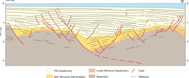
Plio-Quaternary
Mid. Miocene (Serravallian)
Lower Miocene (Aquitanian) Basement Fault Reflector Sea SW-NE 0 1 2 3 0 1 2 3 TWT (s) Figure 6
features (Fig. 5). These fronts are therefore considered to be related to active faults (Perea, 2006; Perea et al., 2006).
In the offshore zones, the analysis of seismic reflection profiles, usually of low resolution and high penetration acquired by oil companies, allowed the detection of faults that displace reflectors corresponding to the Plio-Quater-nary (Fig. 6). Nine faults offsetting the Plio-QuaterPlio-Quater-nary were located in the northwestern margin of the València trough area: one fault in the Gulf of Roses graben, three in the Amposta basin, four in the Cullera cape area and one in the Columbrets basin (Perea, 2006).
3.2. Classification of active faults
The extensional faults along the northwestern margin of the València trough were classified into five types (Fig. 7; Perea, 2006).
a) Faults with clear evidence of large paleo-, histori-cal or instrumental earthquakes. These faults could also provide evidence of accumulated activity during the Plio-Quaternary and/or could be associated with instrumental seismicity. Only two faults have been classified as belong-ing to this type: the Amer fault because it was the source of at least two large historical earthquakes (fault nº 2 in red
Fig. 6.- Cullera cape fault zone. Line drawing of the industrial reflection seismic profile GV-71 in the Cullera cape fault zone (modified from Roca, 1992). Note that the main normal faults offset the lower boundary of the Plio-Quaternary reflectors and that these faults show evidence of long term activity. See section 3.1 for more information about the approach and section 4 for the description of the fault zone. The location of the faults is in Fig. 8 and their parameters are in table 1.
Fig. 6.- Zona de falla del Cabo de Cullera. Interpretación del perfil de sísmica de reflexión con fines industriales GV-71 en la zona de falla del Cabo de Cullera (modificado de Roca, 1992). Nótese que las fallas normales principales desplazan los reflectores localizados en la base de la unidad Plio-Cuaternaria y que estas fallas también muestran evidencias de una actividad de larga duración. Ver la sección 3.1 para más información sobre la aproximación utilizada y la sección 4 para la descripción de la zona de falla. La localización de las fallas se puede ver en la figura 8 y sus parámetros en la tabla 1.
in Fig. 8 and section 4) and the Hospitalet segment of the El Camp fault because paleoseismological studies demon-strated that it has produced large earthquakes since the late Pleistocene (fault nº 5 in red in Fig. 8 and section 4).
b) Faults with evidence of accumulated activity during the Plio-Quaternary and with associated instrumental seismicity. Eight faults of the second type have been iden-tified along the València trough (orange faults in Fig. 8).
c) Faults with evidence of accumulated activity during the Plio-Quaternary and without associated instrumen-tal seismicity. Although these faults show no evidence of
historical or instrumental seismic activity, they have been considered active because they show geomorphologi-cal features similar to those of the two confirmed seis-mogenic faults, one of which, the El Camp fault, shows no instrumental activity. The capability of these faults to produce large earthquakes in the future should therefore be taken into consideration. Seventeen faults of this type have been identified in the northwestern margin of the Valencia trough (yellow faults in Fig. 8).
d) Faults with associated instrumental seismicity and without evidence of accumulated activity during the
Plio-(?) (?) Instrumental seismicity Instrumental seismicity Large earthquakes Large earthquakes Mountain fronts showing recent activity Fault Fault Scheme Scheme Plio-Quaternary reflectors offseted With large earthquakes With Plio-Quaternary activity and associated instrumental seismicity
Onshore faults
Offshore faults
Instrumental earthquakes of low to moderate magnitude
(?)
Observable evidence Possible evidence
Fault with activity record Fault without activity record
Large earthquake (Prehistorical,
historical or instrumental) Seismic reflectors Plio-Quaternary sediments
Sea
Figure 7
With Plio-Quaternary activity and without
associated instrumental seismicity With Plio-Quaternary activity associated instrumental seismicity
and without Without evidence ofactivity or inactive
With large earthquakes
With Plio-Quaternary activity and associated instrumental seismicity
With Plio-Quaternary activity and without
associated instrumental seismicity With instrumental seismicity and without Plio-Quaternary activity associated Without evidence of activity or inactive
Fig. 7.- Classification of the normal faults located in the northwestern margin of the València trough (Perea, 2006). The cross symbols indicate observable (black bold) or possible observable (gray) evidence of Plio-Quaternary activity that characterizes each type of faults.
Fig. 7.- Clasificación de las fallas normales localizadas en el margen noroccidental del surco de Valencia (Perea, 2006). Las aspas indican la presencia de evidencias de actividad Plio-Cuaternaria observadas (negras gruesas) o posibles (gris) que caracterizan cada uno de los tipos de fallas descritos.
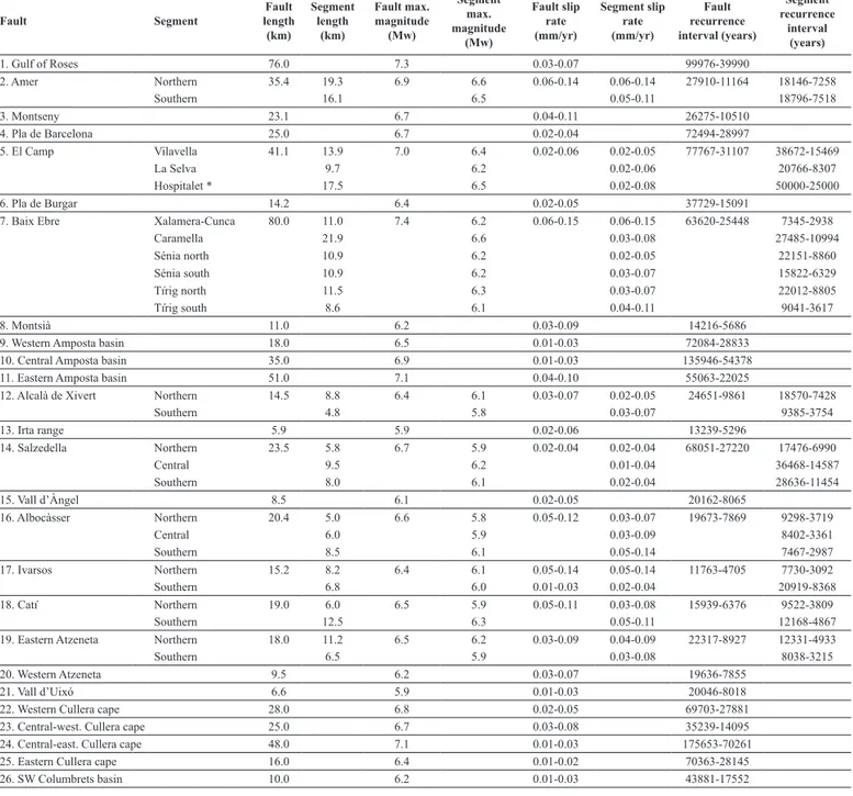
Table 1.- Seismic parameters corresponding to the active faults located in the northwestern margin of the València trough (modified from Perea, 2006 and Perea et al., 2006). Note that the seismic parameters correspond to faults and fault segments that have been classified as “faults with clear evidence of large paleo-, historic or instrumental earthquakes and as faults with evidence of accumulated activity during the Plio- Quaternary and with or without associated instrumental seismicity. The geographical location of the faults, identified by the same numbers, is given in Fig. 8 and they are described in the text.
Tabla 1.- Parámetros sísmicos correspondientes a las fallas activas localizadas en el margen noroccidental del surco de Valencia (modificado de Perea, 2006 y Perea et al., 2006). Nótese que los parámetros sísmicos correspondien a las fallas y segmentos de fallas clasificadas como fallas con claras evidencias de paleoterremotos o terremotos históricos o instrumentales, como fallas con evidencias de actividad acumulada durante el Plio-cuaternario y con asociación de terremotos instrumentales y como fallas con evidencias de actividad acumulada durante el Plio-cuaternario y sin asociación de terremotos instrumentales. La localización geográfica de las fallas, identificadas con el mismo número, se encuentra en la figura 8 y se describen en la sección 4 del texto.
Fault Segment length Fault
(km) Segment length (km) Fault max. magnitude (Mw) Segment max. magnitude (Mw) Fault slip rate (mm/yr) Segment slip rate (mm/yr) Fault recurrence interval (years) Segment recurrence interval (years) 1. Gulf of Roses 76.0 7.3 0.03-0.07 99976-39990 2. Amer Northern 35.4 19.3 6.9 6.6 0.06-0.14 0.06-0.14 27910-11164 18146-7258 Southern 16.1 6.5 0.05-0.11 18796-7518 3. Montseny 23.1 6.7 0.04-0.11 26275-10510 4. Pla de Barcelona 25.0 6.7 0.02-0.04 72494-28997 5. El Camp Vilavella 41.1 13.9 7.0 6.4 0.02-0.06 0.02-0.05 77767-31107 38672-15469 La Selva 9.7 6.2 0.02-0.06 20766-8307 Hospitalet * 17.5 6.5 0.02-0.08 50000-25000 6. Pla de Burgar 14.2 6.4 0.02-0.05 37729-15091
7. Baix Ebre Xalamera-Cunca 80.0 11.0 7.4 6.2 0.06-0.15 0.06-0.15 63620-25448 7345-2938
Caramella 21.9 6.6 0.03-0.08 27485-10994 Sénia north 10.9 6.2 0.02-0.05 22151-8860 Sénia south 10.9 6.2 0.03-0.07 15822-6329 Tírig north 11.5 6.3 0.03-0.07 22012-8805 Tírig south 8.6 6.1 0.04-0.11 9041-3617 8. Montsià 11.0 6.2 0.03-0.09 14216-5686
9. Western Amposta basin 18.0 6.5 0.01-0.03 72084-28833
10. Central Amposta basin 35.0 6.9 0.01-0.03 135946-54378
11. Eastern Amposta basin 51.0 7.1 0.04-0.10 55063-22025
12. Alcalà de Xivert Northern 14.5 8.8 6.4 6.1 0.03-0.07 0.02-0.05 24651-9861 18570-7428
Southern 4.8 5.8 0.03-0.07 9385-3754 13. Irta range 5.9 5.9 0.02-0.06 13239-5296 14. Salzedella Northern 23.5 5.8 6.7 5.9 0.02-0.04 0.02-0.04 68051-27220 17476-6990 Central 9.5 6.2 0.01-0.04 36468-14587 Southern 8.0 6.1 0.02-0.04 28636-11454 15. Vall d’Àngel 8.5 6.1 0.02-0.05 20162-8065 16. Albocàsser Northern 20.4 5.0 6.6 5.8 0.05-0.12 0.03-0.07 19673-7869 9298-3719 Central 6.0 5.9 0.03-0.09 8402-3361 Southern 8.5 6.1 0.05-0.14 7467-2987 17. Ivarsos Northern 15.2 8.2 6.4 6.1 0.05-0.14 0.05-0.14 11763-4705 7730-3092 Southern 6.8 6.0 0.01-0.03 0.02-0.04 20919-8368 18. Catí Northern 19.0 6.0 6.5 5.9 0.05-0.11 0.03-0.08 15939-6376 9522-3809 Southern 12.5 6.3 0.05-0.11 12168-4867
19. Eastern Atzeneta Northern 18.0 11.2 6.5 6.2 0.03-0.09 0.04-0.09 22317-8927 12331-4933
Southern 6.5 5.9 0.03-0.08 8038-3215
20. Western Atzeneta 9.5 6.2 0.03-0.07 19636-7855
21. Vall d’Uixó 6.6 5.9 0.01-0.03 20046-8018
22. Western Cullera cape 28.0 6.8 0.02-0.05 69703-27881
23. Central-west. Cullera cape 25.0 6.7 0.03-0.08 35239-14095
24. Central-east. Cullera cape 48.0 7.1 0.01-0.03 175653-70261
25. Eastern Cullera cape 16.0 6.4 0.01-0.02 70363-28145
26. SW Columbrets basin 10.0 6.2 0.01-0.03 43881-17552
* Seismic parameters of the segment coming from paleoseismological data
Quaternary. Thirty faults have been classified as belong-ing to this type (green faults in Fig. 8). These faults would only be responsible for the low to moderate instrumental seismicity around them but, because of their dimensions, they could also give rise to large events.
e) Faults without evidence of activity (inactive faults). These faults have been considered inactive despite trend-ing approximately perpendicular to the current direction of extension. Thus, one hundred eighty-seven faults are inactive (gray faults in Fig. 8).
" " " " " " " " " " Z L H V C T B G Te 4°0'E 3°0'E 2°0'E 1°0'E 0°0' 1°0'W 42°0'N 41°0'N 40°0'N 39°0'N
±
0 15 30 60 90 120 kmFigure 8
1 4 5 6 12 14 7 15 8 16 9 17 10 18 11 19 3 13 2 20 21 22 23 24 25 26 1. Gulf of Roses 2. Amer 3. Montseny 4. Pla de Barcelona 5. El Camp 6. Pla de Burgar 7. Baix Ebre22. Western Cullera cape 23. Central-western Cullera cape 24. Central-eastern Cullera cape 25. Eastern Cullera cape 26. SW Columbrets basin 15. Vall d'Àngel 16. Albocàsser 17. Ivarsos 18. Catí 19. Eastern Atzeneta 20. Western Atzeneta 21. Vall d'Uixó 8. Montsià
9. Western Amposta basin 10. Central Amposta basin 11. Eastern Amposta basin 12. Alcalà de Xivert 13. Irta range 14. Salzedella Fault classification
Fault with evidence of accumulated activity during the Plio-Quaternary and with associated instrumental seismicity Fault with evidence of accumulated activity during the Plio-Quaternary and without associated instrumental seismicity Fault with associated instrumental seismicity and without evidence of accumulated activity during the Plio-Quaternary
Faults without evidence of activity or inactive Faults with clear evidence of large paleo-, historical or instrumental earthquakes
Fig. 8.- Map (modified from Perea et al., 2006) showing the location of the faults corresponding to each of the different types of active faults (Fig. 7): a) faults with clear evidence of large paleo-, historic or instrumental earthquakes (red lines); b) faults with evidence of accumu-lated activity during the Plio-Quaternary and with associated instrumental seismicity (orange lines); c) faults with evidence of accumuaccumu-lated activity during the Plio-Quaternary and without associated instrumental seismicity (yellow lines); d) faults with associated instrumental seismicity and without evidence of accumulated activity during the Plio-Quaternary (green lines), and e) faults without evidence of activity or inactive faults (gray lines). B: Barcelona; C: Castelló; G: Girona; T: Tarragona; Te: Teruel; V: València. The seismic parameters of the numbered faults and their description are given in table 1 and in the text, respectably.
Fig. 8.- Mapa (modificado de Perea et al., 2006) donde se muestra la localización de las fallas correspondientes a los distintos tipos de fallas activas (figura 7): a) fallas con claras evidencias de paleoterremotos o terremotos históricos o instrumentales (líneas rojas); b) fallas con evidencias de actividad acumulada durante el Plio-cuaternario y con asociación de terremotos instrumentales (líneas naranjas); c) fallas con evidencias de actividad acumulada durante el Plio-cuaternario y sin asociación de terremotos instrumentales (líneas amarillas); d) fallas con asociación de terremotos instrumentales y sin evidencias de actividad acumulada durante el Plio-cuaternario (líneas verdes); y e) fallas sin evidencias de actividad o inactivas (líneas grises). B: Barcelona; C: Castellón; G: Gerona; T: Tarragona; Te: Teruel; V: Valencia. Los parámetros sísmicos de las fallas y su descripción se encuentran en la tabla 1 y en el texto respectivamente..
3.3. Evaluation of the seismic parameters of active faults In order to include the active faults in time dependent seismic hazard studies, it is necessary to have knowledge of the parameters that describe the seismic cycle of each
fault in addition to information about geometry and kin-ematics. These parameters give us an idea of how tec-tonic stress is accumulated and released, i.e. the size and frequency of the seismic events. As a simplification, it is generally assumed that large earthquakes produced by
sociated with instrumental seismicity.
Finally, the time elapsed since the last event can only be obtained from the knowledge of the last earthquake, pre-historic, historical or instrumental. In the northwestern margin of the València trough, this information has only been obtained for the Amer and El Camp faults. For the rest of the faults, identified as active, this parameter has not been reported. However, this does not imply that they cannot be used in seismic hazard studies when the other parameters are known. To compensate for this lack of information, some studies have introduced different per-centages of the recurrence interval as elapsed time (Ojeda et al., 2002; Perea, 2006; Perea and Atakan, 2007).
Despite the different approaches used to estimate the seismic parameters of active faults, it has only been pos-sible to calculate them for 26 out of the 56 identified as active faults in the northwestern margin of the València trough, i.e. those classified as “faults with clear evidence of large paleo-, historic or instrumental earthquakes”, “faults with evidence of accumulated activity during the Plio-Quaternary and with associated instrumental seismicity” and “faults with evidence of accumulated activity during the Plio-Quaternary and without associated instrumen-tal seismicity” (Perea, 2006; Perea et al., 2006). For the “faults with associated instrumental seismicity and without evidence of accumulated activity during the Plio-Quater-nary” only the maximum earthquake can be estimated.
Finally, because of the simplicity of the approaches adopted to identify, classify and characterize the seismic cycle of active faults and because of the widely available information, they can be applied to other areas that are also characterized by low slip faults.
4. Active faults
Below is a review of the main features of the 26 active faults in the València trough of which we have data about their seismic parameters (Fig. 8 and Table 1).
Gulf of Roses fault (fault nº1 in Fig. 8 and Table 1). This fault has been mapped using a number of seismic refraction profiles (Roca, 1992; Roca et al., 1999b). It trends NW-SE, dips towards the SW and is 76 km long. The evidence of its recent activity has been recognized on Profile 80-R-502 (seismic survey 80-R conducted by SHELL in 1980; in Roca et al., 1999b), where the Plio-Quaternary unit is affected by the fault and its base is offset 0.19 s TWTT, which corresponds approx. to 140 m if we consider a seismic wave propagation speed of 1500 m/s. Thus, the slip rate of the fault for this time period varies between 0.03 and 0.07 mm/year (Perea, 2006). Moreover, this fault is responsible for some of the instru-mental seismic activity (Perea, 2006; Perea et al., 2006). the same fault are always identical in terms of rupture
length and offset in accordance with the characteristic earthquake model (Schwartz and Coppersmith, 1984), and that they recur in line with the perfect periodic model (Reid, 1910). Accordingly, the parameters that describe this type of seismic cycle are a) the maximum magnitude earthquake, b) the recurrence interval of this earthquake and c) the time elapsed since the last earthquake.
Because of the long duration of the seismic cycle in slow deformation regions, the seismic parameters should be obtained from paleoseismological studies. Unfortu-nately, only the El Camp fault has been paleoseismologi-cally studied in the València trough. Perea (2006) and Perea et al. (2006) proposed the following approach in order to compensate for the lack of paleoseismological information.
First, the maximum magnitude earthquake was calcu-lated using the empirical relationships that relate magni-tude to surface rupture length (Wells and Coppersmith, 1994). These authors assumed that the mapped length of the fault or fault segment corresponds to the maximum surface rupture length produced by the largest earthquake due to the fault.
Second, the recurrence interval was calculated using the relationship between seismic moment and moment rate proposed by Wesnousky (1986). The only unknown parameter is the fault slip rate given that the maximum magnitude of the earthquake and the dimensions (length and width) of the faults are known and the shear modu-lus is a constant (3*109 dyn/cm2). In the case of onshore faults, the slip rate has been calculated considering the maximum topographic height of the youngest triangular facets as the fault minimum cumulative displacement since the Pliocene (2 to 5 Ma). In the northwestern mar-gin of the València trough, the Pliocene age of the trian-gular facets has been established by comparison with the facets observed at the mountain front associated with the Tet-Cerdanya fault (Briais et al., 1990). The age of these facets is fairly well constrained from correlation with the stratigraphic units defined in the Cerdanya basin (Agustí and Roca, 1987; Cabrera et al., 1988). In the case of off-shore faults, the slip rate has been obtained by measuring the offset at the base of the most recent formation which is Plio-Quaternary (Roca, 1992; Roca et al., 1999b). Pe-rea (2006) demonstrated that slip rates obtained for off-shore faults are usually lower than those calculated for onshore faults. According to this author, this is because the offset measured at the point where the seismic profile cuts the fault does not necessarily coincide with the maxi-mum offset of the fault. This slip rate should therefore be considered as a minimum. Using these approaches, it is not possible to calculate the slip rate for faults only
as-Amer fault (northern and southern segments) (fault nº2 in Fig. 8 and Table 1). This fault marks the western boundary of the Empordà basin normal faults system and offsets the southernmost folded Eocene rocks of the Pyr-enees (Saula et al. 1996). It has a total length of 35km, and because of its abrupt change in direction can be di-vided into two segments: the northern and the southern segments. The northern segment trends NNW-SSE, dips towards the ENE and is 19 km long, whereas the south-ern segment trends NW-SE, dips to the NE and measures 16 km in length (Ferrer et al., 1999; Fleta et al., 2001, Perea, 2006; Perea et al., 2006). The mountain fronts as-sociated with these two fault segments show low sinuos-ity and three generations of triangular facets. In general, the basins are wineglass shaped and regularly spaced. All these geomorphological features indicate that the fault has undergone recent long term activity (Ferrer et al., 1999). The normal fault system of the Empordà basin has accumulated 8.4 km of normal offset during the last 8 Ma (Saula et al., 1996). Accordingly, Lewis et al. (2000) give a long term slip rate of 1 mm/yr for the whole fault system. In the case of the Amer fault, Saula et al. (1996) report 1000 to 1400 m of offset since the beginning of its formation, which is upper Pliocene to lower Pleistocene in accordance with their geodynamic model. Therefore, the fault slip rate for the last 2 Ma ranges between 0.5 and 0.7 mm/year. However, there is no sedimentary evi-dence to date the beginning of the formation of the fault because the zone has been affected by river incision since the sinking of the Empordà basin (upper Miocene). The fault slip rate varies between 0.05 and 0.14 mm/year and has been calculated on the assumption that the maximum height of the youngest triangular facets corresponds to the Plio-Quaternary fault offset, which is 275 m in the northern segment and 225 m in the southern one (Perea, 2006; Perea et al., 2006). The lower slip rates are pre-ferred because they are comparable to those obtained from paleoseismological studies for the El Camp fault (Masana et al., 2001a, b) and because similar strain rates along the region are expected. The Amer fault has been regarded as the origin of some of the instrumental seis-micity recorded in the area and as the source of at least two of the three large earthquakes of the 1427 and 1428 Catalan seismic crisis (Goula et al., 1992). The March 19th 1427 earthquake (Fig. 3a) has been associated with the southern segment of the fault and the May 15th 1427 earthquake (Fig. 3b) has been related to the northern seg-ment (Perea, 2006 and 2009; Perea et al. 2006). Perea (2009) modelled the Coulomb failure stress transfer after each of these two earthquakes. According to this author, the earthquake on February 2nd 1428, the last and largest one of the crisis, could have been generated by the
north-ernmost part of the northern segment of the Amer fault or a fault parallel and close to it. Recently, Font et al. (2008) and Zarroca et al. (2010) have demonstrated the presence of radon gas anomalies related to the southern segment of the fault, which could be linked to its current activity.
Montseny fault (fault nº3 in Fig. 8 and Table 1). This fault is part of the fault system that bounds the Neogene Vallès-Penedès basin to the NW (Roca, 1992; Roca and Guimerà, 1992) between the towns of La Garriga and Breda (Masana, 1995). The upthrown wall is mainly formed by Paleozoic sedimentary and intrusive rocks of the Variscan basement, whereas the Vallès basin, on the downthrown block, is filled with up to 800 m of detritic sediments ranging from the lower Miocene to the Quater-nary (Anadon et al., 1983). Nevertheless, the QuaterQuater-nary deposits are very restricted because of the predominance of the incision processes in the basin. The Montseny fault has a NE-SW direction, dips to the SE and is about 23 km long. The mountain front related to this fault shows low sinuosity, two generations of triangular facets and convex topographic profiles through the crests. The basins are regularly spaced and incised. These geomorphological features indicate its long term activity (Masana, 1995). The cumulative Plio-Quaternary offset is 224 m given that the maximum height of the youngest triangular fac-ets corresponds to this period, yielding a slip rate rang-ing between 0.04 and 0.11 mm/year (Perea, 2006; Perea et al., 2006). The Montseny fault has been considered responsible for an intensity VII earthquake (Fontboté, 1954) that affected the area close to Sant Celoni (north of Vallès-Penedès basin) on March 12th 1927 (Fontserè, 1927; Susagna and Goula, 1999). Moreover, some instru-mental seismicity has also been associated with this fault (Perea, 2006; Perea et al., 2006).
Pla de Barcelona fault (fault nº4 in Fig. 8 and Table 1). This fault bounds the Pla de Barcelona basin to the NW. On the upthrown wall, the Collserola and Garraf ranges are constituted by the Variscan basement and its Mesozoic cover, respectively. The basin located on the downthrown block is filled with Miocene to Quaternary sediments. The main Quaternary morpho-sedimentary units are the Besos delta, the alluvial fans of the Barce-lona plain and the Llobregat delta from north to south. The Pla de Barcelona fault trends NE-SW (Roca, 1992; Roca and Guimerà, 1992), dips to the SE and is 25 km long. There is some evidence of the Plio-Quaternary ac-tivity of the fault. First, Ribera Faig (1945) published a section of faulted Quaternary deposits located at the foot of the mountain front associated with this fault. Second, the analysis of topographic maps of the Barcelona plain made during the second half of the XIXth century for town planning purposes enabled us to locate a
morpho-logical scarp crossing the plain. This scarp is located 2 km from the mountain front, trends parallel to it, and is about 14 km long. The study of geotechnical reports re-lated to the construction of a new underground metro line suggests that the scarp could be associated with a fault that affects Quaternary sediments (Perea, 2006). Finally, the mountain front associated with the main fault shows one clear generation of triangular facets and slightly con-vex topographic profiles through the crests. The basins are wineglass shaped, regularly spaced and incised. All these geomorphological features suggest long term activ-ity of the fault (Perea, 2006; Perea et al., 2006). Given the maximum height of the triangular facets, the accumulated Plio-Quaternary offset is 75 m. Therefore, the slip rate of the fault for this time period ranges between 0.02 and 0.04 mm/year. The Pla de Barcelona fault is responsible for instrumental small magnitude earthquakes (Perea, 2006; Perea et al., 2006).
El Camp fault (La Selva, Vilavella and Hospitalet seg-ments) (fault nº5 in Fig. 8 and Table 1). This fault bounds the El Camp basin to the NW. On the upthrown wall, Var-iscan basement rocks and Mesozoic cover are exposed, and on the downthrown wall, a basin with 1400 to 2000
m of a lower Miocene to Quaternary infill is located (Nuñez et al., 1980; Medialdea et al., 1986). Quaternary alluvial fans extend from the mountain front, which is re-lated to the fault, to the sea. Nevertheless, the fans along the Miramar segment (northern segment of the northern fault section) are restricted to the foot of the mountain front and overlie Neogene deposits (Masana, 1995).The El Camp fault has a NE-SW direction, dips to the SE (Roca, 1992; Roca and Guimerà, 1992) and is formed by two en echelon fault sections separated by a small right lateral step: the northern and the southern El Camp faults.
The northern El Camp fault is constituted by two seg-ments. To the north, the Miramar segment is 15 km long and to the south, the La Selva segment is 13.9 km. Of the two, only the La Selva segment provides evidence of Plio-Quaternary activity. The mountain front associated with this segment has low sinuosity and three generations of triangular facets. The basins are wineglass shaped, regu-larly spaced and moderately to strongly incised. All these features suggest long term activity on the fault (Masana, 1995). The slip rate of the La Selva segment has been obtained on the assumption that the maximum height of the youngest triangular facets, 90 m, is equivalent to the
Scarp ? ? No fault slip ? 3.4 m 1.4 - 2.0 m 0.7 - 1.0 m ? 2.5 m 0.3 m Surface rupture 2.6 m 1.5 m ? ? ? ? Colluvial wedge Colluvial wedge Clastic dykes Colluvial wedge ? Open cracks ? Open cracks Col. Wedge Open cracks 0 25 50 75 100 125 150 175 200 225 250 275 300 325 Years (x1000)
Rifà Creek (Trench 6)
Porquerola Creek (Trench 5)
Ermot (Trenches 4 & 8)
Golf Course (Trenches 1 & 2)
Trench 3
Trench 7
Figure 9
Fig. 9.- Synthesis of the paleoseismic history of the El Camp fault (Perea et al., 2006; Santanach et al., 2010). Black lines correspond to proved seismic events; dark gray lines to deformation events.
Fig. 9.- Síntesis de la historia paleosísmica de la falla de El Camp (Perea et al., 2006; Santanach et al., 2010). Las líneas de color negro corresponden a eventos sísmicos probados; las de color gris oscuro a eventos de deformación.
Perea (2006) and Perea et al. (2006) calculated the slip rate of the two segments of the southern fault on the assumption that the accumulated offset during the Plio-Quaternary was represented by the maximum height of the youngest triangular facets. These authors obtained rates ranging between 0.02 and 0.06 mm/year and dem-onstrated a good correlation between these rates and those derived from paleoseismological studies. Thus, they re-garded as reasonable the slip rates calculated from the height of the triangular facets for the whole northwestern margin of the València trough.
Pla de Burgar fault (fault nº6 in Fig. 8 and Table 1). The Pla de Burgar fault bounds the Plio-Quaternary Pla de Burgar basin to the west (Roca, 1992; Roca and Guimerà, 1992). Triassic and Jurassic carbonate rocks are exposed on the upthrown wall. The fault is N-S trending, eastward dipping and is 13 km long. The mountain front associ-ated with the fault shows only one generation of triangu-lar facets. Its maximum height is 90 m (Masana, 1995), the value assumed to be the Plio-Quaternary accumulated offset and used to calculate the slip rate, which varies be-tween 0.02 and 0.05 mm/year for this time period (Perea, 2006; Perea et al., 2006).
Baix Ebre fault (Xalamera-Cunca, Caramella, Sénia north, Sénia south, Tírig north and Tírig south segments) (fault nº7 in Fig. 8 and Table 1). This fault has created a mountain front that bounds the Ports range (maximum height, Montcaro, 1434 m), which is constituted mainly by carbonate Mesozoic rocks. At its foot, the Baix Ebre basin is filled with Miocene to Quaternary deposits that attain a thickness of up to 400 m (Arasa, 1994). The fault (Roca, 1992; Roca and Guimerà, 1992) trends NNE-SSW, dips to the SE and is 75 km long. It has been di-vided into seven segments on the basis of abrupt changes in direction, front step-overs, and different cumulative seismic behavior as evidenced by the geomorphological features. They are from north to south: Xalamera-Cunca (11 km long), Caramella (22 km long), Sènia north (11 km long), Sènia south (11 km long), Rossell-Xert (15 km long), Tírig north (11.5 km long) and Tírig south (8.6 km long). With the exception of the Rossell-Xert segment, the others display mountain fronts with, in general, low sinuosity, between two and three generations of triangu-lar facets and convex topographic profiles through the crests. Generally, the basins are wineglass shaped, regu-larly spaced and slightly incised. All these geomorpho-logical features indicate long term activity of these fault segments (Masana, 1995; Perea, 2006; Perea et al. 2006). The Plio-Quaternary displacement of these segments is assumed to be the height of the youngest triangular facets of each segment, which is 300 m, 160 m, 100 m, 140 offset accumulated during the Plio-Quaternary. Thus, the
slip rate of this fault segment for this time period varies between 0.02 and 0.06 mm/year (Perea, 2006, Perea et al., 2006). Both segments of the northern El Camp fault account for some of the instrumental seismicity in the vi-cinity (Perea, 2006, Perea et al., 2006).
The southern El Camp fault is composed of two seg-ments: the Vilavella segment, which is 9.7 km long to the north, and the Hospitalet segment, which enters the sea to the south. The onshore length of this last segment is 17.5 km and extends 24 km when the offshore trace of the fault is considered. The mountain front associated with the southern El Camp fault shows geomorphological features similar to those described for the La Selva seg-ment, which suggests its long term activity.
Despite the absence of instrumental seismicity in the surroundings of the southern El camp fault, liquefaction structures including clastic dikes formed by matrix sup-ported conglomerates intruded upwards and colluvial wedges provide evidence of the seismic behavior of the Hospitalet segment (Masana et al., 2001a, b). This is also supported by the presence of a discontinuous scarp run-ning parallel and close to the mountain front of the Hos-pitalet and Vilavella segments and affecting upper Pleis-tocene alluvial fans (Masana, 1995). The proximity of the fault to the Vandellós nuclear power plant prompted the “Consejo de Seguridad Nuclear” (Spanish nuclear secu-rity council) to undertake a paleoseismological study, the first such study in Spain (Santanach et al., 2001). This al-luvial fan has been dated using different methods, such as U/Th, thermoluminescence, radiocarbon and pollen (Vil-lamarín et al., 1999, Santanach et al. 2001), and a paleo-seismological study has been carried out along this scarp, where eight trenches were dug and analyzed (Fig. 2).
The Hospitalet segment has produced at least six large earthquakes during the last 300 ka, three of which oc-curred in the last 125 ka. Figure 9 summarizes the main results obtained during the paleosismological study of the El Camp fault and shows the events per trench, the paleoseismic criteria, and the fault displacement. In the last 125 ka, the slip rate ranges between 0.02 and 0.08 mm/year, the lowest value being the most reasonable. The maximum magnitude earthquake is 6.7 (Mw) with a recurrence interval of 30000 years (between 25.000 and 50.000 years) and the last event is dated at about 3000 years. North of the Rifà creek, beds dated at 140 ka seal the fault, implying that this zone of the fault has not been active since that date (Masana, 1995 and 1996; Masana et al., 2001a and 2001b; Santanach et al., 2001; Perea et al., 2003; Perea, 2006; Perea et al., 2006; Santanach et al., 2010).
long, dips towards the W and causes an offset at the base of the Plio-Quaternary of 0.26 s TWTT, which is equiva-lent to 193 m. Thus, the slip rate of the faults for the Plio-Quaternary ranges, from west to east, between 0.01-0.03, 0.01-0.03 and 0.04-0.10 mm/year. Instrumental seismic-ity is also associated with the eastern fault (Perea, 2006; Perea et al., 2006).
Irta range faults (Alcalà de Xivert fault, northern and southern segments, and Irta range fault) (faults nº 12 and 13 in Fig. 8 and Table 1). The Irta range is a small mountain range that is elongated in a NE-SW direction (Fig. 5). It exposes Mesozoic carbonate rocks and the basins are filled with Neogene and Quaternary detritic sediments (Simón et al., 1983; Simón, 1984; Moissenet, 1989). The western front of the range is bounded by two normal faults that dip towards the NW, the 14.5 km long Alcala de Xivert fault and the Irta range fault, which is approximately 6 km long (Simón et al., 1983; Simón, 1984; Roca, 1992; Roca and Guimerà, 1992). On the Al-calà de Xivert fault, the presence of a mountain front step over and a small change in direction enabled us to distin-guish two segments: the northern (almost 9 km long) and the southern (5 km long). The mountain fronts associated with both faults show low sinuosity, two to three genera-tions of triangular facets and convex topographic profiles through the crest. The basins are wineglass shaped, regu-larly spaced and incised. All these features point to the long term activity of the Alcalà de Xivert and Irta range faults. To calculate the Plio-Quaternary fault slip rate, the maximum height of the youngest triangular facets has been used. The heights corresponding to the northern and southern segments of the Alcalà de Xivert fault are 105 m and 135 m and the height of the Irta range fault is 110 m. Thus, the slip rate of the faults for this time period var-ies between 0.02-0.05, 0.03-0.07 and 0.02-0.06 mm/year, respectively(Perea, 2006; Perea et al., 2006).
Vall d’Àngel range faults (the Salzedella fault, north-ern, central and southern segments, and the Vall d’Àngel fault) (faults nº 14 and 15 in Fig. 8 and Table 1). The Vall d’Àngel range has a NE-SW direction and is formed mainly by Mesozoic detritic and carbonate rocks. The western boundary of the Vall d’Àngel range is control-led by the Salzedella fault (Simón et al., 1983; Simón, 1984; Moissenet, 1989; Roca, 1992; Roca and Guimerà, 1992). A basin filled with up to 245 m of lower Miocene to Quaternary detritic deposits is located on its down-thrown block (Arasa, 1994). The Quaternary units main-ly consist of alluvial fans and fluvial terraces that totalmain-ly cover the northern part of the basin (Simón, 1984; Perea, 2006), whereas to the south, their extent is restricted and Miocene units are exposed. The Salzedella fault trends NE-SW, dips towards the NW and is 23.5 km long. The m, 135 m and 220 m from north to south. Therefore, the
slip rate for this time period varies between 0.06-0.15, 0.03-0.08, 0.02-0.05, 0.03-0.07, 0.03-0.07 and 0.04-0.11 mm/year for each of these fault segments (Perea, 2006; Perea et al., 2006). In the absence of evidence for long term activity of the Rossell-Xert segment, Perea (2006) regards the segment as part of the whole fault in the most conservative models of seismic hazard estimation. Instru-mental seismicity is not associated with any of the seg-ments of the Baix Ebre fault.
Montsià fault (fault nº8 in Fig. 8 and Table 1). The Montisà range is constituted by Mesozoic sedimentary rocks. The basin, located on the eastern side of the range, extends offshore and is filled with sediments ranging from the late Miocene to the Quaternary, with a maxi-mum thickness of 140 m close to the front (Arasa, 1994). The eastern mountain front of the Montsià range is as-sociated with a NE-SW trending fault (Roca, 1992; Roca and Guimerà, 1992), which dips to the SE and is 11 km long. This mountain front displays three generations of triangular facets and basins that are wineglass shaped and regularly spaced. All these geomorphological features point to long term activity of the fault. Furthermore, there is a scarp that runs parallel to the mountain front across Quaternary alluvial fans. This scarp, at its northern and southern terminations, branches into the front coinciding with the presence of small triangular facets. Moreover, a number of small alluvial fans have their apexes at the foot of the scarp. These observations suggest a tectonic origin of the scarp. The Plio-Quaternary slip rate was calculated using the maximum height of the youngest triangular fac-ets, which is 155 m, on the assumption that this height corresponds to the fault offset during this time period. Thus, the slip rate of the fault varies between 0.03 and 0.09 mm/year (Perea, 2006; Perea et al., 2006).
Amposta basin faults (western, central and eastern faults) (faults nº 9, 10 and 11 in Fig. 8 and Table 1). The Amposta basin is located south of the Ebro delta and is bounded by a number of extensive Neogene faults with an approximately N-S direction (Roca, 1992; Roca and Guimerà, 1992). The seismic reflection profile 780-030 (seismic survey 780 conducted by SHELL in 1978; in Roca, 1992) shows that several normal faults displace the base of the Plio-Quaternary unit, three of which offset reflectors very close to the surface. These are the western, central and eastern faults. The western fault, which is 18 km long, dips towards the E and displaces the base of the Plio-Quaternary 0.07 s TWTT, which is equivalent to 53 m (seismic waves speed propagation = 1500 m/s). The central fault, which is 35 km long, dips to the E and off-sets the base of the Plio-Quaternary 0.08 s TWTT, which corresponds to 57 m. The eastern fault, which is 51 km
direction enabled us to distinguish between the north-ern and central segments, and a step over separates the central segment from the southern one. The segments are 5 km, 6 km and 8.5 km long, from north to south. The mountain fronts associated with these segments show low sinuosity, two generations of triangular facets in the northern and central segments and three generations in the southern one, and slightly convex topographic profiles through the crests. The basins are generally wineglass shaped, regularly spaced and in-cised. All these features reveal long term activity of the different fault segments. The height of youngest trian-gular facets is 130, 170 and 240 m for the northern, central and southern segments, respectively, and has been considered as the cumulative Plio-Quaternary displacement. Thus, the slip rate of these segments varies between 0.03-0.07, 0.03-0.09 and 0.05-0.14 mm/year from north to south (Perea, 2006; Perea et al., 2006).
The Ivarsos fault is 15 km long and dips towards the NW. The presence of a step over and a change in direc-tion of the mountain front allowed us to define two seg-ments: the northern and southern segments. The northern segment is 8 km long and the southern one is almost 7 km. The long term activity of these segments is revealed by their geomorphological features. The mountain front shows low sinuosity, two generations of triangular fac-ets and slightly convex topographic profiles through the crests. Furthermore, the basins are wineglass shaped, reg-ularly spaced and incised. The Plio-Quaternary slip rate was calculated from the maximum height of the youngest triangular facets, which is 270 and 85 m for the northern and southern segments, respectively. Therefore, the slip rate of the two segments varies between 0.05-0.14 and 0.02-0.04 mm/year (Perea, 2006; Perea et al., 2006).
Catí fault (northern and southern segments) (fault nº 18 in Fig. 8 and Table 1). The Catí basin is covered by Qua-ternary detritic sediments, mainly alluvial fans that are slightly incised (Simón, 1984; Perea, 2006). To the north-west, the basin is bounded by a NE-SW oriented moun-tain front where Mesozoic carbonate rocks are exposed. This front is associated with the Catí fault, which is 20 km long and dips to the SE (Simón et al., 1983; Simón, 1984; Moissenet, 1989; Roca, 1992; Roca and Guimerà, 1992). A step over allowed us to distinguish two segments: the northern (6 km long) and the southern (12.5 km long). Furthermore, the long term activity of the segments of the Catí fault is evidenced by their geomorphological features. The mountain fronts show low sinuosity, two generations of triangular facets in the northern segment and three generations in the southern one, and slightly convex topographic profiles through the crests. The ba-presence of two step-overs on the mountain front
ena-bled us to define three segments, the northern, central and southern, 6 km, 9.5 km and 8 km long, respectively. The geomorphological features of the mountain front along the three segments are similar and show low sinuosity, two generations of triangular facets (an uncertain third generation on the southern segment) and slightly convex topographic profiles through the crests. The basins are wineglass shaped and regularly spaced. All these features provide evidence of long term activity of the whole fault. The Plio-Quaternary slip rate has been calculated, con-sidering the maximum height of the youngest triangular facets as the accumulated displacement during this time range. These heights are 85, 70 and 75 m for the northern, central and southern segments, respectively, and the cor-responding slip rates varies between 0.02-0.04, 0.01-0.04 and 0.02-0.04 mm/year (Perea, 2006; Perea et al., 2006). Miocene and Quaternary detritic sediments infill the Vall d’Àngel basin located in the central-southern part of the range. This small sedimentary basin trends in the same di-rection as the range and is controlled by the Vall d’Àngel fault located along its eastern margin (Simón et al., 1983; Simón, 1984; Moissenet, 1989; Roca, 1992; Roca and Guimerà, 1992). The Quaternary units consist of small alluvial fans with the source zone located in the upthrown block of the fault. This fault is 8.5 km long and dips to the NW. The mountain front related to the fault shows low sinuosity, three generations of triangular facets and slightly convex topographic profiles through the crests. The basins are wineglass shaped, regularly spaced and incised. All geomorphological features point to long term activity of the fault. The height of the youngest facets is 100 m and has been used to calculate the Plio-Quaternary slip rate. Thus, the slip rate of the fault varies between 0.02 and 0.05 mm/year (Perea, 2006; Perea et al., 2006).
Albocàsser basin faults (Albocàsser fault, north-ern, central and southern segments, and Ivarsos fault, northern and southern segments) (faults nº 16 and 17 in Fig. 8 and Table 1). The Albocàsser basin is a NNE-SSW depression almost completely covered by Quaternary alluvial fans. Notwithstanding, lower Mi-ocene sediments are exposed towards the southeast of the village of Ivarsos, and upper Miocene sediments are located around the village of Albocàsser. The Al-bocàsser basin is bounded by the AlAl-bocàsser fault to the northeast and by the Ivarsos fault to the southwest (Simón et al., 1983; Simón, 1984; Moissenet, 1989; Roca, 1992; Roca and Guimerà, 1992). The mountain fronts associated with both faults expose Mesozoic carbonate rocks.
The Albocàsser fault is ca. 20 km long and dips to the SE. A topographic height and a small change in