Author: Cristina Carnerero Quintero
Facultat de F´ısica, Universitat de Barcelona, Diagonal 645, 08028 Barcelona, Spain.∗
Advisor: M. Carme Llasat
Abstract: In early November 2011 a pertorbation affecting the Mediterranean area led to heavy rainfall and flash-floods in Catalonia and northern Italy. This paper analyses the situation that led to that event and compares the use of different modeling scenarios in the framework of the DRIHM project, which provides tools for the interoperability of meteorological and hydrological models. A synthesis of the main models used in operative simulations for flooding events is also presented.
I. INTRODUCTION
From 1950 to 2005, floods caused more than 2750 deaths in the EU, an average of 50 per year, mainly in the Mediterranean region [1], where floodings are the most dangerous natural hazard, because of the number of vic-tims they cause and the economic losses they generate. Regardless of its mild climate, severe weather episodes are a significant part of mediterranean climate. It is not uncommon to observe hourly rainfall overcoming the lo-cal monthly average, or even daily precipitation surpass-ing the annual average.
Despite this kind of phenomena has been extensively studied, accurate quantification and localization of rain-fall still remains a challenge. Specifically, the difficulty lies in the transformation of precipitation into discharge, specially in the case of flash-floods. In order to improve this situation, teledetection tools are needed (radar, satelite, lightning detection), together with mesoscale meteorological models and distributed hydrological mod-els. In this context arises DRIHM (Dristibuted Re-search Infrastructure for Hydro-Meteorology), an euro-pean project in which Universitat de Barcelona takes part, aiming at facilitating the access of hydrometeoro-logical chains using the power of paralel computation.
In the following sections modeling of severe weather events and numerical weather prediction will be intro-duced, and an application to case studies will be made. Concretely two severe weather episodes that took place in November 2011 in Catalonia and Genoa (Italy) will be studied. Finally some tests using the DRIHM portal will be presented.
II. MODELING
Modelization of extreme weather episodes challenge our current scientific knowledge and this implies neces-sarily a joint hydrometeorological and TIC research in or-der to unor-derstand, explain and forecast physical phenom-ena that cause these events. Against this background,
∗Electronic address: [email protected]
DRIHM introduces the possibility to work in a modu-lar environment through its web portal, in which it is possible to combine meteorological, hydrological and hy-draulic models, taking advantage of the computational efficiency that paralel computing provides.
Numerical Weather Prediction (NWP) consists of sim-ulating future evolution of meteorological variables that determine the state of the atmosphere using meteorologi-cal models. Given the high non-linearity of the governing equations of atmospheric movement, these equations are solved through numerical methods in a series of disposed points within a tridimensional mesh. The resolution of this mesh is given by the discretization of the differential equations and it determines the time of calculation of the simulation.
Moreover, physical phenomena not resolved by the model are estimated using parametrizations, either be-cause their scale is smaller than the minimum scale solved by the model, or due to the extreme non-linearity of the equations describing them. Among this phenomena the most tipical are clouds, convection, radiative fluxes, tur-bulence and the effects of the local orography.
There are two types of forecasts: deterministic and probabilistic. Deterministic forecasts are generated ap-plying a model to the initial conditions of the atmosphere, obtaining a single final state. Besides, probabilistic fore-casts, also called ensemble forecasting, generate a set of solutions starting from the initial conditions. This can be done either applying different models to the initial data or slightly perturbing the initial conditions, so that a model can be applyed to several sets of data, each of which generates an output. Thereby, at the end one has the probability of all the final states of the atmosphere, including the one given by the deterministic forecast.
Within hydrological models a further distinction must be made: there are distributed, semi-distributed and at-tached models.
Among the existing models, meteorological and hydro-logical models used by DRIHM [2] are presented below.
A. Meteorological models
WRF: it is a high resolution NWP model designed both for operative and research applications. It features
two dynamical cores: Non-hydrostatic Mesoscale Model (NMM) and Advanced Research WRF (ARW). Each of them operates in a particular grid and coordinates sys-tem. The model has its own data assimilation system and is highly efficient due to its ability to work in grid computing [6].
MESO-NH: it is a mesoscale atmospheric model developed by M´et´eo-France. It contains a set of non-hydrostatical equations that takes into account a large range of scales, from synoptic to turbulent phenomena. By using grid nesting, it is capable of simulating atmo-sphere dynamics from meso-alpha to micrometric scales. It is therefore particularly accurate when simulating se-vere weather episodes.
The model incorporates a series of physical parametrization, specially advanced for cloud rep-resentation and precipitation. Furthermore, it is coupled with the surface model SURFEX in order to representate ground-atmosphere interactions, considering different types of surfaces (vegetation, oceans, lakes, cities). It is also capable of comparing the model output with satelite, radar and GPS observations [7].
AROME: it is also a mesoscale atmospheric model developed by M´et´eo-France, non-hydrostatic and has a high resolution (2,5 km). It is mainly used in order to forecast short-term severe weather events, specially those involving orography and convection, as intense rainfall, flooding risk or storms. It is also used to predict local phenomena, as fog, heat waves in cities or turbulent ef-fects. It also has its own radar and satelite assimilation system, from which it takes the initial conditions [8].
RainFARM: it is a stochastic downscaling model applicable to rainfall outputs from meteorological mod-els. The model preserves the structure of precipitation field correlations in time and space, and the location of the main precipitation patterns. This allows the model having into account the effect of orography spite of the variation of the scales.
Its goal is to generate several stochastic fields which have the same properties as the mesoscale output in large scale, but differ at smaller scales. In other words, Rain-FARM uses spectral information of large scale forecasts and propagates the information to smaller scales, gener-ating high-resolution rainfall fields [9].
B. Hydrological models
DRiFt: it is a semi-distributed rainfall-runoff model, with constant parameters, aimed to take part in a fore-casting chain. The model takes the initial conditions from measures, satelite data or outputs from meteoro-logical models, from which it takes the rainfall field, to-pography and soil properties. It is based on a geomor-phological approach: the catchment morphology data is
coupled with the modelization of hydrological processes. It also uses a morphological filter in order to identify dif-ferent water channeling paths and soil slopes.
There are two approaches: single site and multi-catchment. The former applies to large basins, calcu-lating the probability of the flow to overcome a certain value. The latter considers a set of catchments inside a given domain, but it deals each of them as a single entity. It is applied to small basins, when the scale of meteoro-logical models is larger than the dimension of hydrologi-cal processes [10].
RIBS: it is a distributed rainfall-runoff model based on the topography of the terrain, used in large and medium basins. RIBS can be run as a deterministic or probabilistic model, and is specially useful forecasting rainfall distribution in a severe weather scenario, since it plots the evolution of saturated areas over the catchment as the storm advances.
Based on simple parametrizations, vertical columns of soil are simulated on each mesh node. This representa-tion allows to define a distriburepresenta-tion of the terrain slope, soil parameters and initial conditions on each point, from which the generation of runoff is simulated [11].
III. APLICATION TO THE CASE STUDY
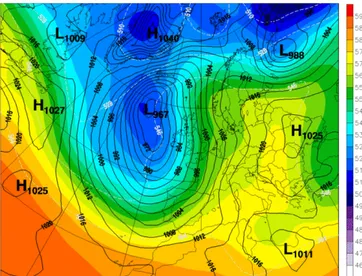
The 2nd November 2011 a deep and cold trough at 500 hPa associated to a synoptic frontal wave stimulated the advection of moisture from the Atlantic over the Mediter-ranean region (see Fig. 1). This situation coincided with a very hot Mediterranean sea, with surface temperatures between 1 and 1.5oC hotter than the last 20 years aver-age [3]. This induced an intensification of the latent heat flow from the sea to the lower layers of the atmosphere.
FIG. 1: 500 hPa NCEP analysis at 00UTC, 3rd November 2011. Pressure in hPa (black) and geopotential height in gpm.
Catalonia the first week of November and continued mov-ing to the east of the Mediterranean as it reintensified itself due to the moist and hot air flow. As it moved, the system caused 5 deaths in southern France and finally reached the Gulf of Genoa, where 6 people were killed on the dawn of 4 November because of heavy rainfall that caused an intense flash-flood in Genoa [1].
A. Catalonia
Heavy precipitation was registered in Catalonia from 2 to 8 November 2011 linked to a slightly convective episode with very convective precipitation peaks. Dur-ing the episode 293.8 mm were registered, 202.9 mm of which were recorded in one day at one station, according to SMC. The resulting floodings caused trapped vehicles by water, flooded buildings, power outages and impor-tant damages in agriculture and beaches, involving losses estimated in more than one milion euros .
The Muga catchment was the most affected. Discharge values at the Muga river peaked 378 m3/s on November 6th at Castell´o d’Emp´uries, while 5 days earlier the flow was only 0.7 m3/s [4].
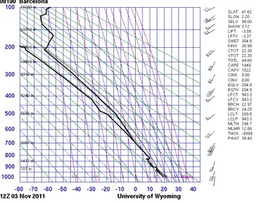
FIG. 2: Radio sounding at 00UTC, 3rd November 2011 for Barcelona.
The trough previously described stimulated the forma-tion of a mesoscalar surface low in front of the catalan coastline the 6 November. This situation favoured the inflow of moist and warm south-east air over Catalonia, and a moisture advection from the Atlantic. The squall line formed moved towards north-east.
As seen in Fig. 2 in the radio sounding for Barcelona at 12UTC, 3rd November, the level of free convection (LFC) was almost at ground level and the equilibrium level (EL) was at 200 hPa, indicating convection at all vertical levels, thus giving a high value of CAPE (1440 J/kg), a usual indicator of strong storm updrafts and
severe weather. Furthermore, the air was completely saturated from ground level to 650 hPa.
An hydrometeorological chain has been applied to this episode in the study carried out by M.C. Llasat [4], where AROME is run using observations and the output is then coupled with RIBS in deterministic and probabilis-tic modes. In both modes different members are gener-ated perturbing the input data.
FIG. 3: AROME rainfall output (above) and discharge simu-lations coupling RIBS (below) for the Catalonia event. Taken from the simulations carried out by M.C. Llasat [4] using the DRIHM platform.
The analysis concludes that the probabilistic mode of RIBS does not provide useful information due to the high uncertainty associated. The results of the deterministic mode, however, show a rainfall distribuition fairly consis-tent with observed values, as proven by the results shown in Fig. 3. This results would have allowed to stablish a flooding warning before the rainfall occurred.
B. Genoa
The early morning of 4 November 2011, the aforemen-tioned trough led to a south-west flow in the upper at-mosphere, that was also detected at surface levels, which brought warm and moist air towards the ligurian coast-line [5]. Radio sounding at 00UTC, 4th November for Mi-lano showed saturated air at all vertical levels. Locally, this conditions caused the development of a mesoscalar convective system (MCS) that triggered in the Gulf of Genoa around 01UTC. The convergence line was gener-ated as a result of the interaction of cold air from north-east and moist and warm air from south-north-east, as proven in the WRF-ARW simulations carried out by E. Fiori [1], shown in Fig. 4. That caused the MCS to slowly move along the ligurian coast as the night went on. It finally got stuck in the westerly genovese mountains at midday,
where it produced intense convective activity, leading to extreme rainfall depth over the Bisgno catchment, where almost 170 mm were registered in one hour [5].
FIG. 4: Wind field at ground level in front of the ligurian coast on 4th November 2011 at 06UTC, from WRF-ARW output. Simulation carried out by E. Fiori [1].
Many researchers have focused in this case study, spe-cially those involving the implementation of hydromete-orological chains. On the one hand, E. Fiori [1] carried out a meteorological study of the episode running WRF-ARW combining different convection and microphysical parametrizations. Amongst all studied configurations, it is concluded that only when no convection scheme is used the obtained results are acceptable.
On the other hand, in the study carried out by F. Sil-vestro [3], RainFARM is first applied on the meteoro-logical forecast used by the Civil Protection System of Italy. The results are coupled with DRiFt, in which sin-gle site and multi-catchment approaches are used. It is concluded that the latter improves the forecast and it is critical in order to correctly describe this kind of events. The study predicts a significant probability of flooding.
Finally, in the work carried out by A. Hally [2] a full hidrometeorological chain is implemented. First, all me-teorological models described in Section II are run. After analyzing which of them is the most accurate, DRiFt and RIBS are coupled. Combinations realized with Meso-NH correctly predict the localization of the observed peak of precipitation. However, neither simulation is capable of simulating the intensity correctly. Even so, all simula-tions would have allowed to issue a warning alert for high risk of flash-flood. Moreover, RIBS is the hydrological model that best fits discharge results. DRiFt gives simi-lar values for intensity but overestimates its distribuition. Summing up, this study shows that when meteorological and hydrological models are coupled, the results improve considerably compared to applying them separately.
IV. USING THE DRIHM PORTAL
Going further, we can take advantage of the tools provided by DRIHM to make a series of tests in order to prove the results already obtained and to determine which benefits provide each one of the studied models.
A set of experiments will be implemented for the case study in Genoa the 4 November 2011 at the Bisagno catchment. First, the effects of downscaling the rainfall field will be tested. Then, a comparison between apply-ing a full hydrometeorological chain and applyapply-ing only a hydrological model with observed precipitation will be made.
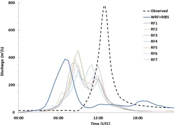
The first experiment implements WRF-ARW, then ap-plies different configurations of RainFARM downscaling and finally couples the results with RIBS in order to get the resulting discharge evolution (Fig. 5). Observed val-ues are also compared. It is here proven that the use of downscaling improves the results of the meteorolog-ical model, as the peak gets closer to observed values, although the intensity and time location is not precise. However, this simulation indicates a clear risk of flooding.
FIG. 5: Results for 4th November coupling WRF-ARW and RainFARM with RIBS. Observations at the gauging station are also compared. Data obtained using the DRIHM portal.
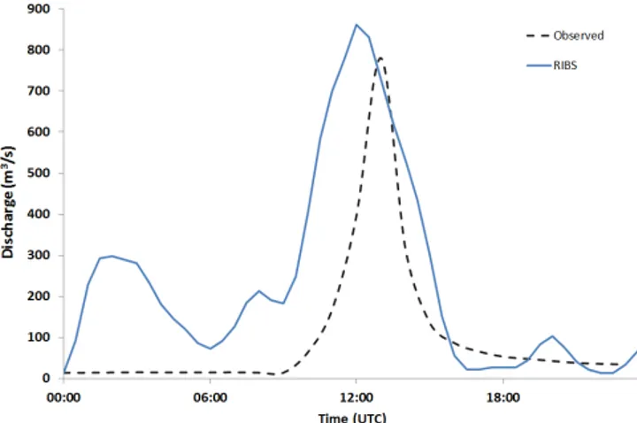
In a second experiment, observed rainfall is used as input to RIBS in deterministic mode in order to fore-cast discharge evolution (Fig. 6). Taking into account that hydrological models always carry uncertainties and therefore their precission is limited, the obtained results are more than acceptable.
A final experiment compares using Arome, Meso-NH or WRF-ARW as input to RIBS (Fig. 7). Comparing Fig. 6 with Fig. 7, a vast difference is obvious. Al-though Meso-NH gets closer in describing the discharge peak, it still remains far from the results obtained when using RIBS with the observed rainfall, instead of a model output. It is worth noting that WRF forecasts the right location of the peak, but not the intensity.
FIG. 6: RIBS discharge output for 4th November with the ob-served rainfall used as input, and observations at the gauging station. Data obtained using the DRIHM portal.
FIG. 7: Discharge results for 4th November using different models coupled with RIBS, and observed values. Data ob-tained using the DRIHM portal, courtesy of Luis Garrote.
V. CONCLUSIONS
On November 2011, two flash-flood took place in the region of the Mediterranean, linked to the same pertor-bation, favoured by a deep trough at 500 hPa and en-hanced by abnormaly high superficial temperatures in the Mediterranean sea. The warm and moist air flow that derived from this conditions impacted on catalan and genovese coast ridges and triggered heavy rainfall all over Catalonia and the city of Genoa.
The studies carried out in the framework of the DRIHM project have revealed the need to execute multi-model simulations, implementing hydrometeorological chains, in order to improve flooding events forecast.
From the simulations made using the DRIHM tools, it can be concluded that each model provides a particular benefit, though none is able to correctly predict the ob-served values. However, it can be concluded that in the best results localizing precipitation and discharge peaks are obtained when Meso-NH and RIBS are coupled to-gether. It has also been proven that downscaling the precipitation field improves final results.
Acknowledgments
My most sincere gratitude and appreciation to my ad-visor M.C. Llasat for her inestimable support, guidance and kind considerations during the elaboration of this pa-per. Furthermore, she nourished my curiosity and pas-sion for meteorology since my first lesson with her, for which I will always be thankful.
I would also like to thank all who supported me in my decision to become a physicist, specially those with whom I walked along pursuing the final goal.
[1] Fiori, E. et al. ”Analysis and hindcast simulations of an extreme rainfall event in the Mediterranean area: The Genoa 2011 case”. Atm. Res. 138: 13-29 (2014). [2] Hally, A. et al. ”Hydrometeorological multi-model
ensem-ble simulations of the 4 November 2011 flash flood event in Genoa, Italy, in the framework of the DRIHM project”. Nat. Hazards 15: 537–555 (2015).
[3] Silvestro, F. et al. ”A hydrological analysis of the 4 November 2011 event in Genoa”. Nat. Hazards 12(9): 2743-2752. (2012)
[4] Llasat, M.C. et al. ”The 6 november 2011 flood event in catalonia: analysis using the DRIHM infrastructure”. Proceedings of the Mediterranean Meeting on Monitor-ing, modelling and early warning of extreme events trig-gered by heavy rainfalls (2014).
[5] Rebora, N. et al. ”Extreme Rainfall in the Mediter-ranean: What Can We Learn from Observations?”. J. Hydrometeorol. 14(3): 906–922 (2013).
[6] Skamarock, W. C. et al. ”A Description of the Ad-vanced Research WRF Version 2”. NCAR technical note NCAR/TN-468+STR (2005).
[7] Lafore, JP. et al. ”The Meso-NH Atmospheric Simulation System”. Annales Geophysicae 16(1): 90–109 (1998). [8] Seity, Y. et al. ”The AROME-France Convective-Scale
Operational Model”. Monthly Weather Review 139(3): 976–991 (2011).
[9] Rebora, N. et al. ”The RainFARM: Rainfall Downscaling by a Filtered Auto Regressive Model”. J. Hydrometeorol. 7: 724–738 (2006).
[10] Giannoni, F. et al. ”A semi-distributed rainfall-runoff model based on a geomorphologic approach”. Physics and Chemistry of the Earth. 25(7-8): 665–671 (2000). [11] Garrote, L. and Bras, R.L. ”An integrated software
en-vironment for real-time use of a distributed hydrologic model”. J. Hydrology 167(1-4): 307–326 (1995).