UNIVERSITÀ DEGLI STUDI DI ROMA
"TOR VERGATA"
FACOLTÀ DI SCIENZE MATEMATICHE, FISICHE E
NATURALI
DOTTORATO DI RICERCA IN BIOLOGIA
EVOLUZIONISTICA ED ECOLOGIA
XX CICLO
HOLOCENE HUMAN PEOPLING OF LIBYAN SAHARA
Molecular analysis of maternal lineages in ancient and
extant populations of Fezzan
CLAUDIO OTTONI
Docente Guida: Prof. Olga Rickards
Holocene human peopling of Libyan Sahara - Molecular analysis of maternal lineages in ancient and extant populations of Fezzan.
The present work provides an important view of a region of Africa that is still almost unknown: the Central Sahara. The aim of the project as a whole, was to reconstruct from the maternal side, through the genetic analysis of mitochondrial DNA (mtDNA), the origins of a Pastoral nomad population in the Libyan Sahara, the Tuareg. The availability of both modern and ancient samples from the Fezzan (Libyan Sahara), collected in collaboration with the Italian Archaeological Mission in Libya directed by Prof. Savino Di Lernia, represented an important means of relating the mtDNA pool of extant Libyan Tuareg, with that of Pastoral people inhabiting the Central Sahara in prehistoric times, and with the Garamantes, the hypothetical ancestors of Libyan Tuareg. Nevertheless, molecular analysis carried out on the bones collected from the archaeological sites of the Acacus region, showed a very low state of preservation of the DNA, this probably due to the high temperatures that characterised burials over the centuries. Failure of the genetic analyses in the ancient individuals, necessarily limited the present work to the study of the extant Tuareg sample. Nevertheless, comparison with other genetic data collected so far in the modern African populations, and moreover the multidisciplinary integration with archaeological and ethnological data, helped to hypothetically reconstruct the origins of Libyan Tuareg, and their relationship with the ancient human migratory dynamics that occurred in Northern Africa during the Holocene.
A total of 129 individuals from two villages in the Acacus region, in Fezzan, were genetically analysed at the mtDNA level. The results here reported clearly show the low level of genetic diversity in the Libyan Tuareg sample, that is hypothetically due to high endogamy. Furthermore, phylogenetic analyses indicate that the mtDNA genetic pool of the Libyan Tuareg is characterized by a major “West-Eurasian” component, that is shared with many Berber groups and hypothetically comes from the Iberian Peninsula, and a minor “South-Saharan” component that
Popolamento umano del Sahara libico durante l’Olocene – Analisi molecolare delle linee materne in popolazioni antiche ed attuali del Fezzan.
Il presente lavoro offre un quadro descrittivo, dal punto di vista genetico, di una regione che è ancora piuttosto sconosciuta: il Sahara Centrale. Lo scopo del progetto è quello di ricostruire attraverso l’analisi del DNA mitocondriale (DNAmt) le origini di una popolazione pastorale Tuareg insediata nel Sahara libico. L’area presa in esame è quella del Fezzan, una regione nella Libia Sud-Occidentale. Per poter risalire ad una eventuale continuità genetica tra i Tuareg che oggi abitano quella regione, e i gruppi umani nomadi che in epoca preistorica occuparono quella zona, sono state effettuate analisi genetiche sia su campioni moderni che antichi, raccolti in collaborazione con la Missione Italiana Archeologica in Libia diretta dal Prof. Savino Di Lernia. Le analisi molecolari condotte sul materiale archeologico a disposizione, hanno evidenziato però il basso stato di conservazione del DNA, probabilmente dovuto alle alte temperature cui le ossa sono state sottoposte all’interno delle sepolture almeno negli ultimi 2,000 anni. Per quanto riguarda il campione moderno, un totale di 129 individui provenienti da due villaggi situati nella zona dell’Acacus, nel Fezzan, sono stati analizzati a livello del DNAmt. Il confronto con i dati genetici di popolazioni Africane attuali presenti in letteratura, e l’integrazione con dati archeologici ed etnologici, ha permesso di ricostruire le origini dei Tuareg in Libia, e di capire in che modo questi sono stati coinvolti nelle migrazioni umane che caratterizzarono il Nord Africa durante l’Olocene.
I risultati riportati nel presente studio evidenziano un livello molto basso di diversità genetica nel campione Tuareg Libico, probabilmente associato a pratiche endogamiche. Inoltre, le analisi filogenetiche indicano che il pool genetico mitocondriale dei Tuareg in Libia è caratterizzato da una componente “Eurasiatica Occidentale” predominante, che è condivisa con alcuni gruppi Berberi Nord Africani e verosimilmente proviene dalla penisola Iberica, e una componente minore di tipo “Sud-Sahariano”, che evidenzia una certa affinità con le popolazioni dell’Africa Centrale e Orientale.
Chapter 1. Introduction……….
11.1 GEOGRAPHICAL CHARACTERIZATION………... 1
The African continent………... 1
The Sahara desert……….. 1
The Fezzan: surveyed area………... 3
1.2 PREHISTORY IN THE ANCIENT CENTRAL SAHARA………... 5
Early Acacus hunter-gatherers……….. 6
Late Acacus hunter-gatherers………... 8
Early Pastoral………... 9
Middle Pastoral………. 9
Late and Final Pastoral………. 10
Garamantian……….. 12
Recent history………... 13
1.3 THE CASE STUDY: THE TUAREG………... 15
Precolonial social structure of the Tuareg: a stratified society………. 17
Precolonial political organization of the Tuareg………... 19
The pastoral circuit………... 21
Relationship with other nomad and sedentary populations……….. 22
The French conquer and the dissolution of the Tuareg socio-political system……… 23
1.4 THE MITOCHONDRIAL DNA……….. 25
Properties of human mtDNA……… 30
1.5 MOVEMENTS OF PEOPLE IN NORTHERN AFRICA: GENETIC EVIDENCE……….. 35
The spreading of agriculture in Northern Africa and the Bantu expansion………….. 35
From Eastern Africa to the Chad basin……… 38
Movements of Pastoral groups: the Fulbe……… 40
People from the Iberian peninsula……… 41
General pattern of mtDNA variability in Northern Africa………... 43
Tuareg: state of the art of genetic studies………. 47
1.6 AIM OF THE PRESENT STUDY……… 48
Chapter 2. Material and methods……….
512.1 SAMPLES………. 51
Ancient samples……… 51
2.2 ANCIENT DNA ANALYSIS: PRECAUTIONS REGARDING CONTAMINATION……… . 53 2.3 DNA EXTRACTION………... 54 Ancient sample………. 54 Extant sample……… 55
2.4 ANALYSIS OF PHYLOGENETICALLY INFORMATIVE REGIONS WITHIN mtDNA………... 55
Analysis of HVS-I and HVS-II in the ancient samples ………... 55
Analysis of HVS-I, HVS-II and phylogenetically informative coding regions in the modern samples……… 56
Sequencing of the whole mtDNA in properly selected haplotypes of the modern samples.……… 57
Ancient samples: cloning of PCR product ………... 57
2.5 ANCIENT SAMPLES: ATTESTING PRESERVATION OF THE BONES………. 59
Thermal Age analysis………. 59
Racemization analysis……… 60
2.6 STATYSTICAL ANALYSIS………... 60
Haplogroup classification………. 60
Database of HVS-I sequences……….. 61
Analysis at the intra-population level: Standard diversity indices and Molecular indices………... 61
Calculation of 95% Credible Region………..……….. 63
Analysis at the inter-population level: Fst genetic distances………. 63
Multidimensional Scaling (MDS)………. 65
Correspondence Analysis (CA)……… 66
Network analysis and Coalescence Ages………. 67
Chapter 3. Results………..
693.1 ANCIENT SAMPLE ………... 69
Genetic analysis……… 69
Thermal Age………. 71
Aminoacid Racemization……….. 72
3.2 MODERN SAMPLE: GENETIC ANALYSIS……… 73
Description of lineages found in the Tuareg sample……… 73
Haplogroup frequencies in the Tuareg sample………. 76
3.3 STATYSTICAL ANALYSES……….. 79
Standard diversity indices and molecular indices………. 79
Comparison of CRS haplotype frequencies……….. 81
Haplogroup V frequencies……… 83 Multidimensional Scaling………. 84 Correspondence Analysis……….. 85 Network analysis………... 91 Star likeness……….. 105
Chapter 4. Discussion………
1074.1 ANCIENT DNA ANALYSIS AND HOT ENVIRONMENTS………... 107
Ancient DNA from hot environments: the story so far ……… 108
State of preservation of the aDNA in the bones from the Libyan Sahara………. 111
4.2 INFERRING PEOPLING OF LIBYAN SAHARA………. 112
Haplogroup composition and genetic diversity in the Libyan Tuareg ………. 112
Analysis at the population level: comparison with other African samples ………….. 120
Gene genealogies: coalescence of the Tuareg lineages………. 122
Chapter 5. Conclusions………..
133Literature cited………...
139Chapter 1.
Introduction
1.1 GEOGRAPHICAL
CHARACTERIZATION
The African continent
Africa is the second largest continent in the world and is inhabited by about the 14% of human population. Its climate is variable: moist air is concentrated around the equator (latitude 5° North and South) and it leads to frequent precipitation, especially in the plains; here the range of temperatures throughout the year is generally low. All this area is covered by the tropical pluvial forest, which in the past was wider than it appears today: traces of its previous extent can be found even in the Gulf of Guinea. The reduction in size of the rainforest probably took place in the last 5,000 years.
Proceeding north and south of the equator, moisture decreases and the vegetation changes. Forests turn into savannas, dry and wet seasons alternate during the year. The more precipitations decreases, the spiner the shrubs and trees become, like baobab and acacia. In both directions, the sub-desert environment is found, and finally the desert. The two main African deserts are both a result the transformation in vegetation described above. The first desert is the Sahara desert, which extends North of the Equator for about a quarter of the whole continent surface. The second one is the Kalahari desert, located south of the Equator in Namibia and Botswana. The Sahara desert, in particular the Libyan Sahara, is the place which this study concentrates on.
The Sahara desert
The Sahara is the largest desert in the world. It is almost as large as the United States, and is larger than Australia. At over 9,000,000 square kilometres, it covers most parts of Northern Africa, an area stretching from the Red Sea, including parts
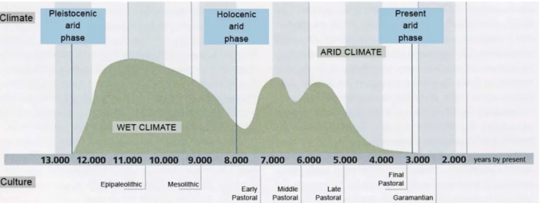
of the Mediterranean coasts, to the outskirts of the Atlantic ocean. It is delimited in its northern border by the Mediterranean sea, and in the southern one by the so-called Sahel-Sudan belt, that extends from the Atlantic Ocean to the Red Sea. About 10,000 years ago, the Sahara region differed considerably from the area we know today. Climatic changes brought heavy rains driven by south-western monsoons, transforming the desert into a verdant landscape. This marked the end of the arid Pleistocene period and attracted animals and humans from southern latitudes. As observed in the graph shown in figure 1.1, the first half of the Holocene was characterized by oscillations of arid and wet periods; these conditions lasted until around 5,000 years B.P.1, when a dramatic, abrupt dry spell set in. This major arid phase of the Middle Holocene, also known as the Mahla event (Hassan 2002), forced human groups to adapt their food security and settlement systems. Since 1,500 years B.P. the Sahara has not changed in appearance from how it is today. The wadis2 that are spread throughout the Sahara, represent remains of the rivers that flowed in the ancient Saharan verdant landscape. These wadis over time changed into deep canyons, turning over hundreds of years into the valleys we find today.
Figure 1.1: Climatic changes in the Central Sahara during the Holocene (Di Lernia mod.).
The climatic crisis of the second half of the Holocene is somehow attested by the reduction in size that characterized the lake Chad. Around 9,000 years ago, a large
1 The quotation refers to uncalibrated radiocarbon years before present.
part of the Chad basin was underwater, eventually giving rise to lake Megachad. It flowed through the Bahr el-Ghazal into the Bodélé plains of northern Chad. It is estimated that lake Megachad covered an area of 330,000 km2. Today it is merely 20,000 km2. Therefore the hypothesis that it is the remains of a much larger lake/sea is quite reasonable (Brunk and Gronenborn 2004, Cerny et al. 2007).
The Fezzan: surveyed area
The Fezzan is situated in the South-Western part of Libya, in the Central Sahara (figure 1.2). It is a region wider than Southern Italy, and contains both homogenous landscapes and complex ones. Located in a remote region of Libya, at the border with Algeria and Niger, the Fezzan is characterized by the presence of two mountain massifs: the Acacus and the Messak Settafet. Both these massifs belong to a system of mountains crossing the Sahara from West to East.
Figure 1.2: Satellite view of the surveyed area (Italian Archaeological
Mission in Acacus and Messak Archive, University of Rome “La Sapienza”).
The Acacus consists of a deeply dissected mountain range composed mainly of Permian and Carboniferous sandstone. East to the Acacus, the Messak Settafet represents a relict plateau, cut out of Cretaceous sandstone. Both the massifs are
ploughed by deep wadis and valleys, and preserve traces of the human occupation since the beginning of the Holocene. The Erg3 Uan Kasa is situated between the Acacus and the Messak, while to the west of the Messak is located the Edeyen of Murzuq. They are sand-seas, characterized by dune-dominated landscapes, and fluvial and lacustrine deposits. The variety of environments that characterized the Fezzan during the Holocene, were able to provide man with many possibilities of adaptation, and so played a key role in the history of human populations that occupied the area (Cremaschi and Di Lernia 1999).
Nowadays, the geological features of the area tell us the history of the past climatic oscillations that characterized the whole Sahara during the Holocene. The main sources of evidence for paleoclimatic reconstruction in the area are the cave and shelter fills in the mountain ranges, and lacustrine or marsh deposits in the interdune corridors located in the erg areas. In the reconstruction of environmental changes, TL-, OSL-, U/Th-4, and radiocarbon-dated geological and geoarchaeological evidences have been used (Cremaschi 1998, Cremaschi and Di Lernia 1999). In parallel, archaeological finds are found throughout the whole area: all these evidence makes it possible to reconstruct how the relationship between humans and the environment changed over time because of the climatic shifts. Geological evidence (Martini et al. 1998) indicates severe desert conditions have existed for 90,000-70,000 years B.P.: these presumably correspond to the beginning of the so-called Ogolian desert encroachment (Cremaschi and Di Lernia 1999). The heavy rains which occurred at the end of the Pleistocene, that correspond to the beginning of the post-Ogolian wet conditions, changed the landscape of Fezzan dramatically: the Wadi Tanezzuft was a river that originated from the massifs of Tassilli and Acacus, flowed toward the North emptying into a sea located in the actual border between Algeria and Libya (Cremaschi 2004). In correspondence to the erg, i.e. the Erg Uan Kasa and the Erg Murzuq, the water collected by the dunes gave rise to large lakes, whose coasts where often inhabited by the pastoral groups.
3 An erg (also sand sea or dune sea) is a large, relatively flat area of desert covered with wind-swept sand with little to no vegetation cover.
In the 6th millennium the water level of the lakes reached its highest, but with the climatic crisis 5,000 years ago, they dried out irreversibely. Similarly, the Wadi Tanezzuft river gradually lost its capacity, its flow being limited to the Acacus region. Yet despite this, over a much longer period it continued to be an important hydrological source in the midst of an even-drier Sahara, and its fluvial activity is recorded as late as 3,800 years ago. The Wadi Tanezzuft fed an over 80 km wide oasis, which provided a refuge for man communities for millennia, even during the second half of the Holocene. The drying up of the river was certainly completed since 2,300 years ago. About 2,000 years ago, when the hyperarid conditions that characterize the Sahara nowadays set in, the contraction of the oasis led to the formation of three separated oases which exist up this very day: Barkat, Ghat and Fehwet (Cremaschi and Di Lernia 1999).
1.2
PREHISTORY IN THE ANCIENT CENTRAL SAHARA
The Saharan mountains of Southern Algeria, Libya and Northern Chad are famous for being of remarkable interest for prehistoric art (Lutz and Lutz 1995, Mori 1965), and for their rich archaeological records (Barich 1987, Lupacciolu 1992, Mori 1965). In fact this area preserves an incredible collection of paintings and engravings attesting the presence of humans in the Central Sahara since the Paleolithic. Rock art tell us many things about customs and way of living of the people inhabiting a region at any given period; in this sense it is an important instrument for reconstructing cultural transitions in a particular geographical context. Paintings depicting exotic and wild animals (e.g. elephants, giraffes, gazelles, rhinoceros) provide evidence of how the Sahara appeared in the first half of the Holocene, as well as the successive phases (figures 1.3a, b, c).
Apart from rock art, many important archaeological sites, from cave sites to open-air sites, can help to reconstruct the life-style of the inhabitants of the Central Sahara. The archaeological survey in the Acacus and Messak Settafet, carried out by the Italo-Libyan joint mission directed by Prof. Fabrizio Mori from 1990 to
1996, led to the identification of more than 450 archaeological sites (Cremaschi and Di Lernia 1999). The geoarchaeological survey of these sites shed light on the cultural dynamics of the human groups in relation to the environmental changes. The Holocene sites with extractive economic basis have been classified as ‛Early Acacus’, and ‛Late Acacus’; those with food-producing economy, as ‛Early Pastoral’, ‛Middle Pastoral’, and ‛Late/Final Pastoral Neolithic’. This terminology has been proposed by Cremaschi and Di Lernia (1999), on the basis of local facies, referred to regional Holocene cultures. The transition from prehistorical to historical time is characterized by the presence of Garamantes, the last cultural phase being named after these people: the Garamantian period. The chronocultural attribution was based on many archaeological indicators: lithic assemblages, pottery samples, faunal remains and spatial configurations of archaeological structures (pits, fireplaces, etc.).
Early Acacus Hunter-Gatherers (ca. 9,800-8,900 Years B.P.)
Geological evidence related to travertine deposits in the Acacus mountain range shows a clear increase in precipitation between 14,000 and 10,000 years B.P., as indicated by U/Th dating. Travertine deposits are the trace of the refilling of the hydrographic network in the mountains; the absence of subsequent travertine deposits indicates that probably this period represented the wettest phase of the late Quaternary. There is no evidence of human occupation in the area recorded at the beginning of this interval. This gap is consistent with the data from other North African contexts (Gabriel 1987, Close 1992, Petit-Maire 1993), and therefore it can be considered as of the time necessary for a significant biological recolonization of a region (Cremaschi and Di Lernia 1996). The oldest ‛Early Acacus’ site was recorded inside the Uan Afuda cave (9765+/−105; GX-20750) (Cremaschi and Di Lernia 1999).
The first Holocene occupation of the area does not appear to be related to any previous Pleistocene occupation, but rather to the arrival of human groups, who probably followed the Sahelian belt. In fact, the hypothesis of a Southern provenance for the ‛Early Acacus’ human groups cannot be discarded (Di Lernia
1997, 1999), above all when considering the evidence of a northward shift of the monsoon across the Sahara (Hassan 1996). Whatever the case, the absence of funerary remains belonging to this phase, and the general feature of the lithic industry showing no peculiar relationship with other complexes, provide no further support to this hypothesis.
Environmental conditions of this period provided an abundance of resources, making specialized forms of hunting possible. Most of the archaeological sites are distributed close to the lakes existing at that time inside the dune corridors, e.g. the Erg Uan Kasa and inside the Edeyen of Murzuq. These lowland sites appear to be small, and archaeological records, mostly based on lithic industry, seem to attest the specialised function of these sites. Other archaeological sites are located in the Acacus mountains, and the archaeological records make it possible to hypothesize the existence of multi-activity base camps in the mountains, characterized by stone structures, shallow hearts and a quantity of lithic artefacts struck from different raw material. Analysis on botanical remains in these sites indicates a narrow range of exploited plants (Castelletti et al. 1998), and up to now no seeds of wild cereals have been found. The almost exclusive presence of faunal remains of Ammotragus
lervia, the Barbary sheep (Corridi 1998), indicates selective hunting practices,
despite apparent evidence of fishing activity in lake sites. It has been hypothesized that the relationship between the multi-activity sites in the mountains and the specialized lowlands ones, is related to a different exploitation of the environment. It is tempting to suggest that human groups during the wet season (i.e. summer) dispersed into the lowlands, while coming together again during the dry season (i.e. winter) in the mountain sites, where the settlements appear larger, and where water sources were permanent (Cremaschi and Di Lernia 1999).
Late Acacus Hunter-Gatherers (ca. 8,900-7,400 years B.P.)
At the end of the Early Acacus phase, geological evidence from the Uan Afuda cave indicates an increasing aridity. Most of the sites that belong to this chronological phase are located in the Acacus area, showing a continuity with the sites of previous
Early Acacus. By contrast, in the dune areas close to the lacustrine or marsh basin, the lowland sites significantly decrease. Mountain sites appear to be larger than the previous ones, and many indicators suggest that they were inhabited for longer periods during the year: organization of lithic technology, grinding equipment, and pottery seem to demonsrate an increase of sedentism. Moreover, the sites themselves were more complex, presenting an organization in separated specialized areas, e.g. fire, fodder stocking, and probably animal corralling. It is likely that human concentration in the mountain sites is related to the drying process, despite a more generic cultural choice cannot be ruled out (Cremaschi and Di Lernia 1999). While in the Early Acacus the economy was specialized around hunting of Barbary sheep and the modest use of plants, in the Late Acacus it was more diversified, with hunting of both small and large mammals, fish, birds and, above all, with a flourishing exploitation of wild cereals (Urochlea/Brachiaria type) and the use of grinding equipment (Di Lernia and Cremaschi 1996, Castelletti et al. 1998). Furthermore, it is worth noting that in the site of Uan Afuda, the first traces of forced enclosure of Ammotragus laervia were recorded. It represented the first attempt of cultural control of these animals in the area, as documented by the accumulation of dung and forage in the more internal part of the cave. A sort of containment of the Barbary sheep and periodical slaughtering of the animals in particular periods has been hypothesized (Di Lernia and Cremaschi 1996, Castelletti et al. 1998).
The shift toward a broad spectrum of resources, and forms of planned exploitation of resources, are a typical response of hunter-gatherer groups to the situations of competition and stress that took place in critical periods, as when population increased, leading to an imbalance between people and resources (Binford 1983).
Early Pastoral (ca 7,400-6,400 years B.P.)
Geoarchaeological evidence (Cremaschi and Di Lernia 1999) indicates that the second half of the Early Pastoral (around 6,900-6,400 years B.P.) was characterized by wet conditions, both in the mountains and the sand seas: it coincided with a dense occupation of both areas. Concerning the settlement system, a continuity seems to be documented between the Late Acacus phase and the Early Pastoral, with the latter system distributing preferentially in the interior areas of the mountains. The settlement pattern seems to indicate the existence of movements between the mountains and the lowlands, probably related to seasonal fluctuations. Movements from the mountain sites to lowlands can be seen as a first form of seasonal transhumance.
The archaeo-zoological records show the absence of continuity with the Late Acacus phase. This can be seen as an evidence of the external provenance of domestic ovicaprines, which were widespread in South-Western Asia while absent in Africa during all the Pleistocene. Bones of sheep and goats have in fact often been recovered between 7,300-7,000 years B.P. in a wide area, from the Red Sea to the Acacus itself (Di Lernia and Liverani 2004). Ovicaprines were probably introduced by Pastoral groups coming from East, who were forced to move westwards because of the increasing aridity in the North-Eastern regions of Africa, driven by the search of water and pastures. Probably the increasing cultural complexity of the Late Acacus hunter gatherers, and their attempt of containining Barbary sheep, favoured the introduction of domesticated animals, whose frequency in the faunal records grew quickly (Di Lernia 1998, 1999). Concerning cattle, whether its origin is autochthons or was introduced by Eastern people is still being debated (Hanotte et al. 2002)
Middle Pastoral (ca. 6,100-5,000 years B.P.)
A short dry period may have occurred at the end of the 7th millennium B.P., as attested by pollen diagrams and cave deposits (Cremaschi and Di Lernia 1999). It corresponds to a drop in human occupation.
The Middle Pastoral appears as the most flourishing period in the Pastoral period. It corresponds to the climax of the Pastoral society, this favoured by the good weather conditions: lakes in the plains reached their highest level, encouraging an increase of human settlements that became larger and more complex than the previous ones. The mountain sites attest the continuous but intermittent presence of humans. The hypothesis of seasonal, probably winter occupations of such sites by shepherds has been made (Cremaschi 1996, Mercuri et al. 1998). A possible scenario is that Pastoral groups settled in the plains and bred bovine and ovicaprines for long periods of the year, while during the dry winter season small groups moved to the mountains, the Acacus and the Messak, with the animals, especially sheep and goats. The fact that bovine archaeological remains are frequent in the plain sites, while rare in the mountains, leads to the hypothesis that they were used mostly for secondary products, particularly milk and blood. The final picture is one of a mature semi-sedentary pastoralism, which resembles that of the extent African pastoralist groups. Evidence of the complexity and maturity of the Pastoral society in this period is related to the rock art. Engravings and paintings depict the physiognomy of the figures, these showing a variety of morphological traits. In fact, the Pastoral society appeared in this period as a multiethnic society: evidence of such heterogeneity comes from the analysis of funerary rituals; this reveals the existence of many traditions and cultures intermingling with each other: e.g., single and multiple burials, differences according to the age and sex of the dead, mummification. In particular, it is worth noting that in this phase, burials are always placed inside the human settlement, indicating a deep continuity between life and death (Di Lernia and Liverani 2004)
Even the physical anthropological analysis confirms the deep-rooted heterogeneity of Pastoral society (Ricci et al. 2008, in press).
Late and Final Pastoral (ca. 5,000-2,700 years B.P.)
Around 5,000 years B.P., weather conditions dramatically changed: dry conditions that characterized this period drastically transformed the Saharan landscape, leading to the complete drying up of lakes. Fluvial activity and water availability are
attested at 3,800 years B.P. only along the Wadi Tanezzuft. Dessiccation was certainly completed by 2,300 years B.P.. High population density, overgrazing, and the uncontrolled use of resources contituted factors of deep stress and competition in the Pastoral society. Archaeological surveys show that the substantial homogeneity and unity of the Middle Pastoral is fragmented by the birth of regional entities, which resulted from humans adaptation to the climatic crisis. Both nomad and sedentary communities characterized this periond.
Nomad pastoralism. The new climatic conditions forced human groups to adapt their settlement system and their economy. Food security could no longer be provided by bovines, but only by more resistant animals, e.g. ovicaprines. Settlements consist of moderately-sized camps in the plains which were inhabited during the summer season, while hundreds of shelters were used as sites of settlement in the mountains. They were distributed over a wide area, both in the Acacus and in the Messak, and were occupied during the winter season. These small sites were mostly used as stables for goats (Cremaschi and Di Lernia 1999). The exclusive use of ovicaprines, and the nomad pastoralism based on the annual mobility, are distinctive markers of this phase. This new kind of pastoralism attests the necessity for the man to continuously move to find new pastures, akin in this regard to the modern desert nomadic life-style.
Communities of the oases. In an environment ever more dominated by increasing aridity, fluvial valleys (e.g. the Wadi Tanezzuft valley), and their paleo-oases became a focal point of human concentration, which may have favoured some forms of sedentism, with intensive use of plant resources (Di Lernia and Livereani 2004). In these regions, control and access to resources acted as critical factors which led to the first forms of social stratification. This aspect is reflected in the funerary architecture too: for the first time megalithic structures appear in the pastoral culture. Tumuli, platforms and other rock monuments clearly represent evidence of hierarchical structure in the oases-communities (Di Lernia and Livereani 2004).
At the end of the Pastoral period, human communities appear to be completely adapted to the dry conditions. Little is known about the society of the Final Pastoral, although it appeared to be well structured and complex. Long-distance tradings with foreign people (e.g. sorghum in West Africa, and date palm in East Africa) clearly demonstrate the dynamic nature of these communities that crossed the Sahara desert looking for new resources. The relationship between these organized Pastoral communities and the Garamantes that followed are still open of debate.
Garamantian (2,700-1,800 years B.P.)
Toward the mid of the 2nd millennium B.C. (Before Christ) the transformation process of Saharan communities was complete. Oases were reduced their present size (e.g. the oases of Ghat, Barkat, and Fewet in the Wadi Tanezzuft), and allowed the human groups to cultivate date palms, cereals, and leguminous plants.
In this period, the establishment in the Saharan border of trading centres for trans-Saharan exchanges, represents an important factor triggering the origin of the first state-entities based on sedentary settlements, like those in the Southern Saharan border along the Sahel-Sudan belt. At the same time, Greek (Cyrenaica) and Phoenician (Tunisia and Tripolitania) colonies were founded on the Mediterranean coast. Herodotus wrote about the opening of the first caravan route crossing the Sahara through Fezzan, from Lower Egypt to the middle valley of Niger. Through this trade system Garamantes brought salt from the Central Sahara to the Chad basin, exchanging gold and other exotic products. These were subsequently transported to Mediterranean, in return for oil and manufactured products (e.g. glasses, ceramic, jewels). The Herodotus’s writings attest the birth in that period of new ethnic groups in the Central Sahara, such as Garamantes themselves in the Fezzan, Atlantes in the Hoggar, and Nasamoni south of Cyrenaica.
The first Garamantian settlements date back to the 6th century B.C.. The Garamantes had their most important centre in Germa, in the Wadi el-‘Ajjal. Excavations conducted since 1997 by the Italo-Libyan joint mission, shed light on two important Garamantian sites situated in the southern region of the kingdom: the
citadel of Aghram Nadharif, near the oasis of Barkat, which provides a clear evidence of the trade activities of the Garamantes; and the village of Fewet, which attests the agricultural exploitation of the oasis. Since the 1st century B.C., contacts with the Roman empire, concurrently with the diffusion of metallurgy, led to the continuous growth of the Garamantian kingdom.
Recent history
Around the 3rd-4th century A.C. (After Christ) the Garamantian reign reached its peak. Agricultural activities were improved through new techniques, i.e. the
foggara, a system of underground irrigation channels. The dromedary was used as a
beast of burden instead of donkey, as it afforded higher resistance in the desert for the trade systems. Settlements became more stable and complex, while many changes were also observed in the funerary culture.
In the mid of the 4th century, the crisis of the Roman Empire and consequently of the Mediterranean trades in the African provinces, led to the decline of the Garamantian kingdom itself. From 632 A.C. onwards saw a period of Arabic expansion, that in Africa at first limited to Egypt and the Mediterranean coast. During the Omayyadi Caliphate, in the 7th and 8th century, Arabs reached Maghreb (Whitehouse 1980), and later advanced southward, both to West and East. In the 9th and 10th century, Muslim colonizers reached Eastern Africa, while at the beginning of this millennium Bedouins repeatedly invaded Northern Africa. During this time, many Tuareg pastoralists were driven southwards and were displaced by Arab Bedouins who settled in Tripolitania and the Fezzan. Elsewhere in the Sahara, the Tuareg were able to defend most of their territories, but also to assimilate certain Arab tribes that had ventured southwards (Capot-Rey 1953, Nicolaisen 1963).
Figure 1.3a: Acacus
phase. During this phase hunter-gatherers groups settled Sahara. Rock art is characterized by realistic representations of wild animals that human groups hunted. Animals depicted (e.g. gazelles, but even elephants, giraffes, rhinoceros) attest that the Sahara at the beginning of the Holocene appeared as a
Figure 1.3b: Pastoral phase.
During the Pastoral period cattle, that represented the main source of human groups, became the main subject of the rock art. Differently from the Acacus phase, often humans were depicted too, and scenes of both social and work activities were represented.
Figure 1.3c: Garamantian
phase. During this period the Sahara almost appeared as it is today. Human groups settled around the oases, that were represented in many paintings. Dromedaries, which were introduced during this phase being more resistant to the desert environment, were often depicted too.
1.3
THE CASE STUDY: THE TUAREG
The origin of the Tuareg is quite confused: the scarcity of written chronicles prevents us from reconstructing their history exactly. Most Arabian historians and geographers5 attribute to the Tuareg a descent from Arabic or Semitic populations who reached Maghreb after various military campaigns, and who progressively entered the South of the region, intermingling with local Berber populations (Lhote 1955, Hama 1967). The origin and meaning of the name Tuareg (Twareg) has long been debated with various etymologies advanced, although it would appear that
Twārəg is derived from the broken plural6 of Tārgi, a name whose former meaning was ‘inhabitant of Targa’ (the Tuareg name of the Libyan region commonly known as Fezzan).
The Tuareg speak a Berber language: the Tamajaq (also called Tamasheq or
Tamahaq, according to the regions where it is spoken), which appears to have
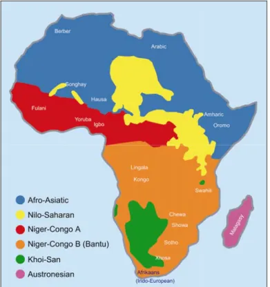
several dialects among the different regions. The Berber language belongs to the Afroasiatic family, which encompasses about 240 languages spoken in Northern Africa from Egypt to Morocco (except for a region in Southern Libya where Nilo-Saharan languages are spoken), in Eastern Africa (Eritrea, Ethiopia, and Somalia) and in the Middle East and the Arabic peninsula. More particularly, the Berber branch is spoken by most of nomadic Northern African shepherds and is closely related to Pharaonic Egyptian and the Semitic languages (such as Arabic, Hebrew, and Amharic).
The Tamajaq writing system, Tifinagh (also called Shifinagh and Tifinar), descends directly from the original Berber script used by the Numidians in pre-Roman times (source: Smithsonian Institute, http://africa.si.edu/exhibits/tuareg/who.html).
5 Among them: Ibn Kaldoun, Ibn Abd Al H’akam, Yakout, Ibn Hokal, and Ibn Batoutah (Tornieri 2002).
6In linguistics ‛broken plurals’ are a grammatical phenomenon typical in many Semitic languages of the Middle East and Ethiopia, in which a singular noun is "broken" to form a plural by having its root consonant embedded in a different ‛frame’, rather than by merely adding a prefix or suffix to the original singular noun.
Despite the common language and culture, the Tuareg population has always been divided into different groups. Each group appears as a mosaic of traditions and tribes often in conflict with each other. During the Middle Ages, the Tuareg were organized into two major groups: the Ihaggaren, the so called Northern Tuareg, which were located in the Ahaggar massif; and the Tademaket, known as Sudanese Tuareg, who were settled in the Adrar des Iforas in Mali. In figure 1.4, the precolonial geographic distribution of Tuareg in Africa is reported.
In the 16th – 17th century these two groups fragmented, probably because of internal struggles, into the confederations which characterised the pre-colonial time (see forward): Kel Ahaggar and Kel Ajjer, in the present-day Algeria, Kel Adrar in Mali, and Kel Ioullimmidden in the Western Niger.
Figure 1.4: Precolonial geographic distribution of Tuareg in Africa (Wikipedia, Tornieri 2002).
Other isolated nomad tribes reached the Aïr region in the 10th century, mixing with local autochthonous populations. Here, the organization into a confederation was decided only after the arrival of some groups from Kel Ahaggar, who were attracted
by the rich pastures of the region. When the French army conquered the Sahara between the end of 19th and the beginning of the 20th century, the Tuareg were organized in the following confederations (Lhote 1955, Hama 1967, Tornieri 2002):
− Ihaggaren o Kel Ahaggar: placed in the Ahggar massif, in Algeria.
− Kel Ajjer: settled in the Tassili-n-Ajjer, near Ghadames and the Western part of Libyan Fezzan.
− Kel Ioullimmidden: located in the Boucle of Niger. They included the Kel Adrar, who after independence from this confederation were subjects of the Kel Ahaggar.
− Tenguéréguif, who inhabited the region of Timbuktu, in Mali.
− Kel Aïr, who include the Kel Geres, located in Damergou, and the Kel Ewey and Kel Ferwan, in the Aïr massif.
No stable political relationships were ever established between the confederations. Sometimes, neighbour tribes of different confederations stipulated military alliances against common enemies. Only during the French invasion were alliances between whole confederations established, but these never led to the Tuareg unification.
Precolonial social structure of the Tuareg: a stratified society
Despite a certain cultural unity, it is not totally correct to speak about a Tuareg society: as previously described, many independent regional entities exist as a result of different social and geographic contexts. It is possible to provide a general description of the Tuareg and their relationship to territory, something common in all the Tuareg groups (Tornieri 2002).
Organization of precolonial Tuareg society is based on a rigid division in social classes, which reflects the separation into tribes. They are the result of long-term processes influenced by hegemonic classes, who try to maintain their privileges over generations. A social structure appeared in the precolonial times as follows.
Imajeghan. They represented the hegemonic class in the context of the Ettebel, i.e.
the confederation. Only descent from such a tradition enabled one to be the leader of the Ettebel, who is called Amenokal.
They represented the upper class, possessing camels and lands near the oases which were generally cultivated by the slaves (Iklan). Wars represent their main activity and is what confers to Imajeghan the supremacy. Hooting and raids on the neighbouring camps of other tribes belonging to a different ettebel, or on the sedentary agricultural villages were often carried out in the dry season. Animals, slaves and precious objects were taken during these raids, and people were submitted to the control of the Imajeghan. Sometimes, political and commercial matters, or disputes concerning control of pasture, could cause wars involving tribes or even whole confederations. The lower classes were subjects of the Imajeghan as they were the only ones who could grant them protection against attacks from the
Imajeghan of other tribes: access to means of warfare was in fact a peculiarity of
this hegemonic class.
Imghad. They were shepherds who generally were allowed to possess only goats.
Their submission to Imajeghan constituted a form of an annual tribute obliging them to provide the Imajeghan animals and other alimentary resources, and to participate in wars or raids.
They were politically organized in tribes, whose leader was autonomously elected among them. In fact, the Imajeghan generally did not interfere with the political issues of the Imghad. In the context of the Ettebel, the leaders of the Imghad tribes, could vote for the Amenokal in an assembly together with the Imajeghan.
Ineslimen. They represented the religious class. Their social importance varied
according to the confederation: sometimes they were not organized in tribes, and could receive the same social status of the Imajeghan, so that marriages between these two classes were allowed. On the other hand they could be subjected to the noble class, and were organized into politically autonomous tribes based on a pastoral economy.
Enaden. They were artisans who worked with wood, leather, and metals. The Enaden generally lived together with the Imajeghan or the Imghad in the same
camp, so they usually were not organized into separated tribes. Often, not more than two families lived in the same camp, and were never really integrated in the life of the camp as they were despised on account of being manual workers: they represented the lowest class among the ‛free men’. Their marginal position was emphasized, linguistically, by the use of a peculiar dialect, the tenet, which was hardly understood by the other groups.
Mythical sources attribute to the Enaden a different origin in respect to the other Tuareg groups of free men: their descent probably derives from autochthonous South-Saharan populations external to the Tuareg.
Iklan. They were the slaves, who were generally captured by the Imajeghan during
their raids, or bought from the Arab merchants of Tidikelt or Timbuktu (Mali). The
Iklan took care of all the manual activities in the camps, from agriculture to
breeding, as all manual work was despised by the Imajeghan. The Imghad and the
Enaden could also possess slaves. They were completely estranged from social and
political life, and were treated as private objects which could be exchanged in the social transactions.
Precolonial political organization of the Tuareg
The political organization of the Tuareg society was based on two entities: the tribes (Tawshit) and the so-called confederations (Ettebel).
The confederation: Ettebel. As mentioned before, Tuareg were divided into confederations of tribes, the Ettebel. Each Ettebel was governed by the Amenokal, who was chosen among the tribes of Imajeghan. Composition of tribes corresponded to the different social categories, and could significantly vary from confederation to confederation. A tendency for slaves to be more numerous in the South was observed: from about 10% of the whole confederation in the Sahara, to even 70-80% in the Sahel-Sudan belt (Bernus 1981). The Imajeghan were always a minority, while the number of Imghad could vary.
Even external non-Tuareg groups could belong to the Ettebel, which in this sense was a very flexible political structure. Independently from their origin, foreign groups that could strengthen the Ettebel were allowed to participate in the socio-political life of the confederation, submitting themselves to its authority (e.g. the Arabs, who often were admitted into the Ettebel because of their guns) (Capot-Rey 1953, Nicolaisen 1963).
The tribes: Tawshit. Tribes were composed of individuals of the same social category who shared the same geographical area. Belonging to the tribe was defined by matrilineal descent: all the individuals descended by the common female ancestor. However, these blood ties were often weakened by adoption practices or protectorate relationships. The demographic size of the tribes could widely vary, both between different tribes, and within the tribe itself. In fact, wars, alliances, and even weather conditions (e.g. extreme dry seasons), could lead a faction of one tribe to move and join other ones. According to a study conducted by F. Nicolas in 1950, the confederation of Kel Ferwan was composed of 25 tribes, whose size varied from 25 to 635 individuals, with an average of 250 (Nicolas 1950, Nicolaisen 1962). It clearly suggests that the demographic profile of the confederations could be highly complex.
Tribes were strictly endogamic, especially the noble ones: in fact, marriages were allowed only between couples from the same tribe. Only exceptionally were marriages between people from different social categories authorized. Strict rules were generally followed after marriage: the new familiar nucleus settled in the camp of the bride’s parents, up to the birth of the first son, when they had to move to the camp of the groom’s parents. After the death of the man, the woman and her sons moved back to her mother’s territory.
The camp: Aghiwan. In the context of each tribe, the exploitation of the resources, i.e. water and pasture, was carried out at the camp level (Aghiwan). This was the context in which the pastoral activities were carried out, and so, in contrast to the confederation and the tribe, it had a economic connotation. The nomad life-style of
the Tuareg led to the continuous movement of camps, whose time of stay in a particular place was generally associated with a series of pastoral cycles.
The practice of the pastoral activity was carried out at the family level. The camp was composed of a man and his wife, their sons with respective wives and sons, and their nubile daughters (or in case, divorced or widow daughters with their sons). Generally all the decisions about the pastoral activities were taken by the oldest man in the camp, who even decided when to move to another region and where to go.
The pastoral circuit
The flock is generally composed by ovicaprines, camels and sometimes bovines and horses, especially in the Sahel area. Size and composition of flocks change according to the tribe they belong to (noble or tributary) and to the weather conditions (alternation of wet and dry periods). A precise organization concerning the choice of pastures is followed according to the species of animals, to their abundance, and to the availability of manual workers and resources, in particular water. It results in a very specialized pastoralism that aims to reduce competition among the animals and the pressure on pastures-land. The hardest moment is during the warm and dry season, when water demands increase while its availability is drastically reduced. It leads to the concentration of many shepherds near the same water source, i.e. the wells, this critical situation causing degradation of pasture and food shortage for the animals.
Movement of camps follows a cyclical trend and is strictly related to seasonal variation. Rainfall during the wet season leads to the growth of new pastures and marks the beginning of a new year. Frequency of movements during the year can vary in relation to the area and the availability of resources, abundance of rain in the last wet season, and the particular demands of the human groups. Camps can move as many as five or six times in a year (Bernus 1986).
During the wet season, that can last up to three months, camps generally settle in areas protected from the rainfall. Rainfall is sufficient to renew pastures with grass and water. During this period, high availability of resources allows the camps to
meet up and people from different groups to gather for rituals and sport competitions (tendè). Once the wet season ends, the landscape soon starts to dry. Temperatures begin to decrease and the camps disperse, looking for new locations in the valley. This period coincides with the dry and cold season. With the arrival of the hot season camps further disperse over a wider area. It coincides with the hardest period of the year: the grass is completely dry, and some animals die because of the lack of resources. Camps are forced to move with a higher frequency looking for new pastures to exploit. The arrival of the rains coincides with the progressive concentration of camps and so with the beginning of a new cycle.
Relationship with other nomad and sedentary populations
Both nomad (Arabs, Bedouin, Toubou etc.) and sedentary populations (Songhay, Hausa, Djerma) shared the same territory with the Tuareg populations: their cohabitation led to various results. In fact, while some nomad groups have been integrated in the political, but not cultural life of the Tuareg (e.g. the Arabian group Eddès Deremshaka and Peul), often sedentary populations have found themselves subjected to military oppression, being the object of raids and ambushes (Bernus 1969, 1981, Tornieri 2002). Furthermore since the Middle Ages, caravan routes, strongly contributed the incentives for Tuaregs to establish contact with other foreign groups. Generally, trade was directed toward the Sahel-Sudan region where millet and animals were exchanged, or to the Saharan-Sudan region in order to exchange salt, dates and millet.
Two important commercial bases were at the centre of the trade system, one located in the Sudan region, the other in the Maghreb area, near the oasis of Ghat. A reconstruction of the caravan pathways in the Central Sahara is reported in figure 1.5.
Figure 1.5: Caravan pathways in Central Sahara (Tornieri 2002).
The French conquer and the dissolution of the Tuareg
socio-political system
At the beginning of the 20th century, the French army finally conquered the Sahara, after many years of battle. The long period of war and the rebellion of Tuareg groups between 1916 and 1919, led to a severe weakening of the Tuareg socio-political system: the Imajeghan, who were directly involved in the battles, were decimated to a small minority, and lost control over the lower social groups. In this sense, French domination destroyed the traditional dependence/protectorate relationships at the basis of Imajeghan’s power and of their tributary system: in
fact, the colonial authority interposed between the nobles and the lower social classes, who had not to ask for protection anymore.
A completely new organization of tribes followed the Tuareg’s defeat. French authority set most of the slaves free, and disassembled the confederations. Tribes were often divided or mixed each other, and were substituted by ‛artificial groups’ that were forced to settle in more accessible areas, so as to allow the French aouthority to have more control on them (Giazzi 1996). A significant decline of pastoralism is observed in this period: nomad tribes were confined to precise areas according to the new administrative rules, and the progressive contraction of the pastoral activities to small spaces was at the basis of frequent conflicts between nomads and agricultures, who were supported by the French administration. In this period it was also frequent that small tribes joined to richer group in order to survive.
Concurrently to the progressive decline of Imajeghan, a political and economical growth of Imghad and Ineslimen, and even an enrichment of the old slaves, was observed. In fact, once free from their noble owners, slaves had the access to private property and could keep their own flocks. Anyway, it is worth noting that only with the independence, in 1960, slavery was completely abolished.
In the recent history, it has to be noted that during Keddafi's Jamahiriya revolution, many Tuareg came to Libya from
Chad, Algeria and Niger, and settled in the South of the country. Many of them underwent a process of sedentism near Ghat and Ubarj (Gaudio 1993). According to recent population size estimates, nowadays Tuareg are more than 1,300,000 in Northwest Africa. Recent census counted about 17,000 Tuareg in Libya (http://www.ethnologue.com), within which 5,000 are distributed in Fezzan
Figure 1.6: present distribution of Tuareg in Africa
and speak the dialect of Ghat, that is one of the most important inhabited area in Fezzan. In figure 1.6 the present distribution of Tuareg is reported.
1.4
THE MITOCHONDRIAL DNA
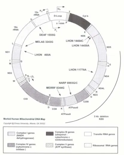
Human mitochondrial DNA (mtDNA) is a circular double-stranded molecule, 16,569 base pairs (bp) in length, that corresponds to the 0.0006% of the total haploid human genome (about 3x10⁹ bp). The two strands that compose the mtDNA are different in basis composition, so that they are named ‛Heavy’ (H, rich in Guanidine residues) and ‛Light’ (L, rich in Cytosine residues). No introns or repeated sequences are present in mtDNA, and it represents one of the most known eucaryotic genomes as its complete sequence has been studied in many organisms. In humans, first complete sequencing of mtDNA was performed on an Englishman (Anderson et al. 1981). Since then, this sequence has been used as a reference for all human mtDNA sequencing studies, and it is termed Cambridge Reference Sequence (CRS). In 1999, CRS was reanalysed and revised (rCRS) (Andrews et al. 1999). Mitochondrial DNA codes for 13 subunits of the oxidative phosphorylation system, two ribosomal RNAs (rRNAs), and 22 transfer RNAs (tRNAs) (Anderson et al. 1981, Korhonen et al. 2004). It is present in hundreds to thousands of copies in each cell, not within the nucleus, but within the cell’s energy-generating organelles, the mitochondria. In figure 1.7, a schematic map of mtDNA is shown. The mtDNA consists predominantly of coding DNA, with the exception of a 1100-bp long fragment that has mainly regulatory functions and is therefore termed the Control Region (CR). Within the CR, two hypervariable regions are present, i.e. the Hypervariable Sequence I (HVS-I) and the Hypervariable Sequence II (HVS-II). As mtDNA encodes essential components of the cellular energy production apparatus, lesions in mtDNA and mitochondrial dysfunction contribute to many metabolic human diseases (e.g. MELAS, MERFF, ataxias).
Figure 1.7: Mitochondrial DNA map. Nucleotide positions associated
with mitochondrial human diseases are indicated.
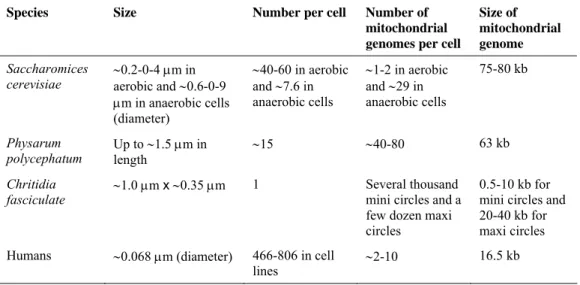
Organization and inheritance of mtDNA remain poorly understood. Mitochondrial DNA is packaged in protein-DNA complexes that are associated to inner membrane of mitochondria (Stuart et al. 2005), and are called, by analogy to the bacterial chromosome, mitochondrial nucleoids. In table 1.1, an interspecies comparison of mitochondrial nucleoids is reported. Proteins involved in the replication (Korhonen et al. 2004), transcription (Gaspari et al. 2004), repair (Stuart et al. 2005), and perhaps recombination (D'Aurelio et al. 2004, Tsaousis et al. 2005) of mtDNA are among the nucleoid components. Recent findings indicate the existence of a dedicated apparatus that coordinates nucleoid segregation with mitochondrial dynamics and cell division (Azpiroz and Butow 1993, Nunnari et al. 1997,
Okamoto et al. 1998, Boldogh et al. 2003). In yeast, it has been observed that proteins Aco1, Abf2, and Ilv5, are directly involved in the metabolic remodelling of mitochondrial nucleoids (Chen and Butow 2005, Chen et al. 2005), as reported in Figure 1.8.
TABLE 1.1
An interspecies comparison of mitochondrial nucleoids.
Species Size Number per cell Number of mitochondrial genomes per cell
Size of mitochondrial genome
Saccharomices
cerevisiae ∼0.2-0-4 μm in aerobic and ∼0.6-0-9 μm in anaerobic cells (diameter) ∼40-60 in aerobic and ∼7.6 in anaerobic cells ∼1-2 in aerobic and ∼29 in anaerobic cells 75-80 kb Physarum polycephatum Up to ∼1.5 μm in length ∼15 ∼40-80 63 kb Chritidia
fasciculate ∼1.0 μm x ∼0.35 μm 1 Several mini circles and a thousand few dozen maxi
circles
0.5-10 kb for mini circles and 20-40 kb for maxi circles Humans ∼0.068 μm (diameter) 466-806 in cell
lines ∼2-10
16.5 kb
Figure 1.8: Hypothetical function of Aco1, Abf2, and Ilv5, in the metabolic remodelling
of mitochondrial nucleoids in yeast (Chen and Butow 2005).
Since the first in-depth study of human mtDNA variation 25 years ago (Brown 1980), mtDNA has become widely used for studies of human evolution, migration, and population histories (Johnson et al. 1983, Cann et al. 1987, Vigilant et al. 1991,
Torroni et al. 1993, Krings et al. 1997, Melton et al. 1998, Reed and Stoneking 1999, Ingman et al. 2000, Tambets et al. 2004). In figures 1.9a, b, c, some schematic representations of human mtDNA phylogenies, and their use in the reconstruction of human migrations in the past, are reported. This widespread use is due to the unique features of mtDNA that make it particularly amenable to evolutionary studies. These features include the high copy number, the mathernal inheritance, and the lack of recombination.
Figure 1.9b: One of the latest representation of mitochondrial DNA evolutionary tree (Olivieri et al.
2006).
Properties of human mtDNA
High copy number. The average somatic cell has just two copies of any given nuclear gene or DNA segment, but hundreds to thousands of copies of mtDNA (Robin and Wong 1988). More particularly, each nucleoid contains up to ten mtDNA molecules, and between 400-800 nucleoids are present in one single human cell (Chen and Butow 2005). The high copy number, along with the extranuclear, cytoplasmic location of mtDNA, makes it easier to obtain mtDNA for the genetic analysis, and also makes mtDNA the molecule of choice for analyzing ancient DNA and for certain forensic DNA applications. On the other hand, the multiple copies of the mtDNA genome within one individual need not to be identical, a topic that is called heteropolasmy. More precisely, heteropolasmy is the state in which a cell contain genomes that are genetically different (Chen and Butow 2005). Current best estimate of heteropolasmy is that about 14% of the population has a second mtDNA type present at a frequency of at least 1% (Tully et al. 2000), and indeed it is quite likely that all of us harbour more than one mtDNA type among the many mtDNA genomes in our bodies. Nevertheless, the overall homogeneity of mtDNA within individuals indicate that during the early stages of the oogenesis, a substantial bottleneck occurs (see next paragraph). Recent studies on segregation of mtDNA across generations hypothesized that only ten segregating units per individual exist (Bendall et al. 1996, Brown et al. 2001, Poulton and Machington 2002).
Mathernal inheritance. Human mtDNA is characterized by a strictly maternal inheritance (see Figure 1.10) (Stoneking 1993, Stoneking and Soodyall 1996, Wallace et al. 1999). The hypothetic process responsible for the maternal inheritance, is the selective destruction of sperm mitochondria in the oocytes after fertilisation (Manfredi et al. 1997, Shitara et al. 1998). In fact paternal mtDNA is marked for destruction through ubiquitination mechanisms. It is worth noting that recently, mtDNA from muscle tissue of a man affected by mitochondrial myopathy, showed a predominantly paternal origin (Schwartz and Vissing 2002). Nevertheless, this case remains an exceedingly rare phenomenon: in fact, subsequent investigations of more patients with the same mitochondrial dysfunction have
yielded no further cases of paternal inheritance (Filosto et al. 2003, Taylor et al. 2003, Schwartz and Vissing 2004). Therefore, at present maternal inheritance of mtDNA in humans can still be regarded as a rule (Schwartz and Vissing 2003). Up to now, exceptional paternal inheritance of mtDNA in mussels (Zouros et al. 1992), and inter- and intra-specific hybrids in Drosophila, mouse and birds (Gyllensten et al. 1991, Kaneda et al. 1995, Kondo et al. 1990, Kvist et al. 2003), have been observed.
Figure 1.10: Representation of maternal inheritance in mtDNA
(http://www.ncl.ac.uk/nnp/research/mrg/advice/inheritance.htm).
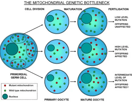
It should be noted that an embryo generally inherits from its mother identical copies of mtDNA, so homoplasmy is a matter of fact since the first hours of life. The first studies on mtDNA inheritance between generations were realized in Holstein cows pedigrees with a heteroplasmic mtDNA polymorphism (Hauswirth and Laipis 1982). A complete shift of mtDNA genotype between an animal and its descendant was shown to occur rapidly, over two generations. Heteroplasmy was then considered as a transient state of mtDNA returning to homoplasmy over generations. To account for the rapid segregation of mtDNA variants, a genetic bottleneck for mtDNA in the female germ line or in the early embryo was proposed (see Figure 1.11). Studies on mice showed that segregation of the mtDNA
genotypes probably occurs in oogonia, in which the number of mtDNA molecules per cell is reduced to 200 (Jenuth et al. 1996). During female germ line development, mitochondria and mtDNA molecules are both amplified, but the volume of the organelles and the amount of mitochondrial rRNA and mRNA increase ten times more than the mtDNA copy number, leading to a dramatic decrease of the number of mtDNA molecules per mitochondrion (Malka et al. 2006). During maturation of the primary oocyte, the number of mtDNA molecules increases one hundred fold. Further segregation takes place during cytoplasmic partition of the oocyte in the early embryogenesis, and in the following separation of the endoderm, mesoderm, and ectoderm, and migration and division of primordial cells in the undifferentiated gonad. This process explains the segregation of different mtDNA genotypes between tissues (Hauswirth and Laipis 1985, Macmillan et al. 1993, Chinnery et al. 1999). Alteration of the bottleneck effect due to defects in the organization and inheritance of mitochondrial nucleoids, could significantly change ratio of wild-type to mutant mtDNA molecules in the cells of a specific tissue, resulting in many mitochondrial disorders (Di Mauro and Schon 2001, Taylor and Turnbull 2005).
Figure 1.11: Model of genetic bottleneck in the female germ line proposed to
The haploid inheritance of mtDNA leads to two significant consequences. The first one is that mitochondrial genome has a smaller ‛effective population size’ (Ne) than nuclear genes: this is estimated 1/4 of the nuclear genome. In fact, a couple of interbreeding individuals possess potentially four haploid nuclear genomes, but only one mtDNA genome to transmit to the next generation. This process is responsible of a higher rate of local differentiation through drift.
The second consequence of the uniparental inheritance, is the absence of segregation and recombination. It allows researchers to trace back over time related lineages, highlighting the maternal ancestry of a population without the confounding effects of biparental inheritance and recombination that characterize the nuclear DNA.
Lack of recombination. The absence of recombination in mtDNA has been demonstrated in many papers (Stoneking 1993, Stoneking and Soodyall 1996, Wallace et al. 1999, Pakendorf and Stoneking 2005). In 1999-2000 four paper claimed evidence for mtDNA recombination in humans (Awadalla et al. 1999, Awadalla et al. 2000, Eyre-Walker et al. 1999, Hagelberg et al. 1999), but all these studies were subsequently shown to be based on faulty and questionable statistical and phylogenetic methods, and new analysis of the same data gave no significant results. Subsequent studies (Ingman et al. 2000, Elson et al. 2001, Piganeau and Eyre-Walker 2004) could not find any evidence of recombination even in data sets from complete mtDNA sequences, although an excess of homoplasic7 sites was
detected, hypothetically due to heterogeneous mutation rates that characterize human mtDNA. It is worth noting that recently, recombination in human mtDNA was detected in the only individual so far observed with biparental inheritance: recombination between the maternal and parental contribute occurred in approximately 0.7 % of the total mtDNA in the patient’s muscle tissue. Mitochondria possess a functional recombinase (Thyagarajan et al. 1996), but paternal leakage is an extremely rare phenomenon, and it is still unclear to what extent mitochondria within a cell fuse, and exchange their content (Enriquez et al.
7Homoplasy: the generation of the same state by independent means (convergent evolution) (Jobling et al. 2005).
2000, Ono et al. 2001Legros et al. 2002). So, in the absence of heteroplasmic DNA molecules, any recombination event would result in identical molecules.
High Mutation rate. The mutation rate of mtDNA is much higher than that of nuclear DNA. The estimated rate is 0.017 x 10⁻⁶ substitutions per site per year for the whole genome excluding the CR (Ingman et al. 2000, Pakendorf and Stoneking 2005). In the HVR-I and HVR-II of the CR, the rate is even higher, although exactly how high is a matter of controversy: estimates based on inter-/intra-specific phylogenetic comparisons range between 0.075-0.165 x 10⁻⁶ substitutions/site/year (Hasegawa et al. 1993, Stoneking et al. 1992, Tamura and Nei 1993, Ward et al. 1991). Nevertheless, significantly higher rates (0.47 x 10⁻⁶ substitutions/site/year) were estimated through direct observation of mutations in families or deep-rooting pedigrees. It is worth noting that within the CR the mutation rate is very heterogeneous, with some ‛mutational hot spots’ mutating even four or five time as fast as the average site (Excoffier 2002, Hasegawa et al. 1993, Heyer et al. 2001, Meyer et al. 1999, Stoneking and Soodyall 1996, Wakeley 1993). In this sense, the discrepancy between phylogenetic- and pedigree-based estimates could be explained by the fact that pedigree studies preferentially detect fast-evolving site, whose mutations have arisen recently and will not probably become fixed. Differently, phylogenetic studies, that encompass a larger number of transmissions, collect information from mutations that have reached an appreciable frequency in the population, which belong even to slowly evolving site (Heyer et al. 2001, Jazin et al. 1998, Macaulay et al. 1997, Pakendorf and Stoneking 2005, Pakendorf et al. 2003). In this sense, the phylogenetic rate may be preferable for studies of deep history, whereas the pedigree rate is preferentially used for studies of recent history (Macaulay et al. 1997, Pääbo 1996).
As the present work deals with human phylogeny, the phylogenetic rate of mutation will be used. Furthermore, it is worth noting that the fast mutation rate that characterize in general mtDNA, makes it a good genetic system for studying recent micro-evolutionary events like human origins.