DOTTORATO IN SCIENZE DELLA TERRA XXI° CICLO
Coordinatore: Prof. William Cavazza
Tesi di Dottorato
Stratigraphy and Palaeontology of the Late Cretaceous Wapiti Formation, west-central Alberta, Canada
Stratigrafia e Paleontologia della Wapiti Formation (Cretaceo Superiore), Alberta centro-occidentale, Canada
Presentata da: Relatori:
Dr. Federico Fanti Prof. Gian Battista Vai Prof. Octavian Catuneanu
Introduction
Paper 1: Stratigraphy of the Upper Cretaceous Wapiti Formation, west-central Alberta, Canada.
Federico Fanti and Octavian Catuneanu
Paper 2: Bentonite chemical features as proxy of Late Cretaceous provenance changes: a case study from the Western Interior Basin of Canada.
Federico Fanti
Paper 3: Fluvial sequence stratigraphy: the Wapiti Formation, west-central Alberta, Canada. Federico Fanti and Octavian Catuneanu
Paper 4: A high latitude vertebrate fossil assemblage from the Late Cretaceous of west-central Alberta, Canada: evidence for dinosaur nesting and vertebrate latitudinal gradient. . Federico Fanti and Tetsuto Miyashita
Paper 5: Upper Campanian Borioteiioidean lizards from Kleskun Hill, west-central Alberta (Wapiti Formation), Canada.
Randall Nydam, Michael Caldwell, and Federico Fanti
Unfolding the geological history of the North: new comprehensive survey of the Wapiti Formation, Alberta, Canada
Federico Fanti and Octavian Catuneanu, 2008:
Sequence Stratigraphy of the Fluvial Wapiti Formation, Grande Prairie region, Alberta, Canada
A complete stratigraphic assessment and revision of the middle Campanian to upper Maastrichtian Wapiti Formation in north-western Alberta and north-eastern British Columbia is the main aim of this research project. The study area encompasses an area of approximately 200X180 km in the Grande Prairie County (west-central Alberta) and easternmost British Columbia, Canada. Results presented here indicate that the 1300m thick succession currently reported in the literature as “undifferentiated lithostratigraphic unit”, consists of five lithostratigraphic units and four unconformity-bounded depositional sequences; their study and description have been documented integrating several geological disciplines, including sequence stratigraphic methods, well-log signatures, facies analysis, and fossil associations. On the whole, particular attention has been given to 1) age and nature of both basal and upper contacts of the Wapiti Formation, 2) effective mappability of lithostratigraphic units and depositional sequences in western Alberta, and 3) the identification of previously undetermined maximum flooding surface of the Bearpaw seaway and Drumheller Marine Tongue, which are reference marine unit in central and southern Alberta. A second, but not less important, guideline for the project has been the rich paleontological record of the Wapiti deposits. Detailed paleoenvironmental and taxonomical information on old and new finds have been the base for correlation with well known associations of Alaska, southern Alberta, and Montana. Newly discovered rich fossil localities documented an extraordinarily diverse fauna during the latest Cretaceous, including dinosaurs, squamates, and fresh-water fishes and reptiles.
Lastly, in order to better characterize the Wapiti Formation, major marker beds were described: these include several bentonites (altered volcanic ash deposits) which have been documented over an area of almost 30.000 km2, as well as four major coal zones, characterized by tabular coal seams with an overall thickness of 2 meters. Such marker beds represent a formidable tool for high-resolution chronology and regional correlations within the Late Cretaceous Alberta foreland basin.
1300 metri correntemente indicata in letteratura come “unità litostratigrafia indifferenziata” consiste in cinque unità litostratigrafiche e quattro sequenze deposizionali a limiti inconformi. La loro descrizione e analisi si basa sull’integrazione di diversi approcci nell’ambito delle scienze geologiche, tra cui la stratigrafia sequenziale, analisi di log geofisici di sottosuolo, analisi di facies, analisi geochimiche e associazioni fossilifere. Nel complesso, particolare attenzione è stata rivolta a 1) età e natura dei contatti a base e a tetto della Wapiti Formation, 2) alla mappabilità delle unità litostratigrafiche e delle sequenze deposizionali a scala regionale e 3) all’identificazione delle maximum flooding surfaces della Bearpaw Formation e della Drumheller Marine Tongue, entrambe unità marine di riferimento nell’Alberta centrale e meridionale.
Al fine di verificare la presenza di livelli guida e soprattutto di verificare variazioni nell’area sorgente dei sedimenti della Wapiti Formation, diversi livelli bentonitici (documentati in un’area di circa 30.000 km2) e importanti intervalli ricchi in strati di carbone sono stati descritti in dettaglio ed analizzati mediante studi di geochimica. Tali strati ed intervalli rappresentano un fondamentale strumento sia per correlazioni a scala locale e regionale che per l’inserimento delle diverse unità stratigrafiche in una scala temporale di riferimento.
Una seconda linea guida di questa ricerca è stata l’analisi del ricco contenuto paleontologico della Wapiti Formation. Una dettagliata analisi tassonomica e paleoambientale è stata fondamentale per le correlazioni biostratigrafiche con le note associazioni paleontologiche dell’Alaska, dell’Alberta meridionale e del Montana. La scoperta di nuove località fossilifere documenta una fauna straordinariamente diversificata durante il Cretaceo Superiore che include dinosauri, squamati, uccelli, e pesci e rettili di acqua dolce.
1. Geological framework
The original geological studies of the uppermost Cretaceous-Tertiary strata in the Alberta foreland basin applied formational ranking to the facies associated with the three coarse-grained, diachronous sedimentary wedges, giving rise to names such as the Milk River, Belly River, and Edmonton groups. As further stratigraphic studies were completed, it became apparent that these strata were widely variable in thickness and lithofacies, resulting in the introduction of additional names to further refine the stratigraphic nomenclature. Where these additional formations have been defined, the original formation has commonly been elevated to group status, thus creating the Belly River Group, (Oldman and Foremost formations), the Edmonton Group, (Horseshoe Canyon, Whitemud, Battle and Scollard formations), and the Saunders Group, (Brazeau, Coalspur and Paskapoo formations). However, this process has not been undertaken universally across the basin, and has resulted in a confusing nomenclature. Further complicating the issue is the application of American stratigraphic terminology to define units in Canada, as exemplified by the introduction of the Judith River Formation (McLean, 1971) and Claggett Formation (Wasser, 1988). Within the context of this study, the stratigraphic nomenclature as shown on Figure 1 is applied.
Where the Belly River Group is undifferentiated, the name Belly River Formation is used. The Horseshoe Canyon Formation name is used and the term Edmonton Group disregarded to allow compatibility between equivalent formations in Alberta and Saskatchewan. Foothills nomenclature is that of Jerzykiewicz (1985). In northwest Alberta, strata equivalent to the Belly River, Horseshoe Canyon, and where present the Whitemud and Battle formations were previously jointly defined as the Wapiti Formation (Dawson et al., 1992).
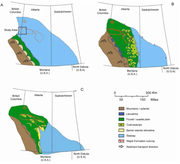
The uppermost Cretaceous-Tertiary stratigraphic interval forms an integral part of the foreland basin of the Western Canada Sedimentary Basin. The formations that lie within this interval provide a unique geological record of the final development of the basin and the relation of that development to tectonics, eustasy and climate. The geological history of this interval can be interpreted in terms of a series of tectonic events to the west, with resultant erosion and widespread sediment supply into the basin, interspersed with periods of limited sedimentation and/or marine transgression. In the middle Campanian, (~78 Ma), during deposition of the Foremost Formation and basal Wapiti deposits, the source of sediment was principally normal to the deformation front (i.e. from the southwest).
Later, during deposition of the Oldman Formation, the sediment source shifted to the west-northwest, probably as a result of reactivation of mountain building in the northern regions. Following the deposition of the Belly River wedge (lower Wapiti Formation), a widespread marine incursion from the southeast occurred, giving rise to the sediments of the Bearpaw Formation (~76 Ma). The Bearpaw Sea extended from southeast Saskatchewan to north of Edmonton. Farther to the north, beyond the limit of marine deposition, continental sedimentation continued unimpeded. Such deposits are represented by the late Campanian deposits of the Wapiti Formation (Figure 2)
principally from the northwest and west. Depositional environments of the aggrading section varied from shallow marine and deltaic near the base to fluvial near the top. The upper strata of the Horseshoe Canyon Formation include a widespread coal zone (Carbon-Thompson), which is overlain by a distinctive, whitish, kaolinitic siltstone (Whitemud Formation) and dark grey mudstone (Battle Formation). This stratigraphic interval is represented by regionally extensive coals in the Wapiti Formation. It is probable that at this time (~66 Ma), the foreland basin was essentially filled, and that isostatic rebound of the basin accompanied by a major environmental shift may have been responsible for the regional disconformity at the top or within the Battle Formation (Figure 2).
Lastly, during the late Maastrichtian (~66-64 Ma), renewed tectonic activity and downwarping of the western half of the foreland basin led to the deposition of a third clastic wedge. The lower Scollard and its equivalents are essentially barren of coal and extend throughout most of the basin.
2. Wapiti Formation project
The Wapiti Formation, which outcrops extensively in northwestern Alberta and northeastern British Columbia, is a sedimentary succession that represents a time interval going from the middle Campanian to the early Maastrichtian. As such is temporally equivalent to the Belly River Group (Foremost, Oldman, and Dinosaur Park formations), the Bearpaw Formation, and the Edmonton Group (Horseshoe, Whitemud, and Battle formations) of southern and central Alberta (Eberth, 1990, 2002, 2005; Eberth and Hamblin, 1993; Dawson et al., 1994a, b; Jerzykiewicz and Norris, 1995; Eberth and Brinkman, 1997; Brinkman et al., 1998; Catuneanu et al., 2000; Bachu and Michael, 2003; Brinkman, 2003; Lerbekmo et al., 2003), all known for their abundance of fossil vertebrates and high diversity of dinosaur taxa. In the last decade, field activities in the Grande Prairie district resulted in the discoveries of several important fossil localities, among the richest ever found in Alberta and North America, which include hadrosaur and ceratopsian-dominated bonebeds, dinosaur skeletons, isolated material ascribed to tyrannosaurs and ankylosaurs, trackway localities, microvertebrate sites, insects in amber, and megaplant fossils. Despite these promising discoveries, the stratigraphy of the Wapiti Formation and its unique dinosaur faunas remained for decades virtually unknown. In fact, except for a few paleontological reports (Tanke, 2004) and articles on the coal potential of the region (Allan and Carr, 1946; Byrne, 1955; Stott, 1961; Dawson et al., 1994b), the geological and paleontological importance of the area has been unstudied. Factors such as remoteness of outcrops, vast extent of the study area, vegetation cover, and high operational
Figure 2: Schematic paleogeography during the deposition of the Wapiti and coeval successions in western Canada. A, 83 Ma, Lea Park Formation; B, 78 Ma, maximum Foremost Formation progradation; C, 73.4 Ma, maximum transgression of the Bearpaw seaway.
In the Grande Prairie area and farther west into British Columbia, the Cretaceous foreland basin pinches out along the Alberta Syncline, and because of the local geo-tectonic setting is entirely exposed along major and minor drainage systems. In addition, intense oil and gas exploration activity in this area provides excellent subsurface control. Major outcrops are situated on overall bidirectional pattern that reflects north-south oriented tributaries flowing into east-west trending rivers. In this study, helicopter and jet boat explorations were combined with surface mapping and
East (long. 118°) to Tumble Ridge, British Columbia in the west (long. 121°), and from the Grande Cache area in the south (lat. 54° 04’) to Bad Earth Creek in the north (lat. 55° 40’).
3. Objectives
The initial development of the research project has been following two main guidelines: the first integrate several geological approaches (geophysics, geochemistry, facies analyses, petrography, etc.) in order to provide an high resolution stratigraphic revision of the entire sedimentary succession and to refer discrete stratigraphic intervals, disconformities, marker beds, and major fossiliferous sites to a robust chronostratigraphic framework (Figure 3). The second one has the specific target to obtain detailed paleoenvironmental and taxonomical information to correlate vertebrate taxa from northern Alberta to those in Alaska, southern Alberta, and northern US. In fact it must be considered that the Wapiti succession lies in a relatively poorly known section of the Alberta foreland basin: lacking any marine depositional event, it plays a unique role in our understanding of basin fill timing and processes, as well as vertebrate dispersion and paleobiogeography along the western margin of the Western Interior Seaway (Figure 2).
4. Results
Five scientific papers form the bulk of this study: in addition, other related publications are included in the appendixes. In particular:
Paper 1: Stratigraphy of the Upper Cretaceous Wapiti Formation, west-central Alberta, Canada. Accepted manuscript, Canadian Journal of Earth Sciences.
In this paper is discussed the subdivision of the Wapiti Formation into regionally mappable lithostratigraphic units and the correlation of such units with the better known successions of central and southern Alberta
Paper 2: Bentonite chemical features as proxy of Late Cretaceous provenance changes: a case study from the Western Interior Basin of Canada.
In this paper are defined depositional sequences in the Wapiti Formation providing a case study where 1) both downstream and upstream controls on fluvial processes can be discussed, and 2) regionally extensive coal seams represent MFSs within proximal, exclusively alluvial deposits.
Paper 4: A high latitude vertebrate fossil assemblage from the Late Cretaceous of west-central Alberta, Canada: evidence for dinosaur nesting and vertebrate latitudinal gradient.
In press., Palaeoegeography, Palaeoecology, Palaeoclimatology.
This paper consists of a detailed paleoecological and taxonomical analyses of a new microsite and a discussion on its stratigraphic and palaeobiogeographical implications. The site represent the northernmost dinosaur nesting ground in North America known to date. Taxa recovered at the site provide insights into Late Cretaceous vertebrate latitudinal gradient along the Western Interior Basin.
Paper 5: Upper Campanian Borioteiioidean lizards from Kleskun Hill, West-Central Alberta (WapitiFormation), Canada.
Accepted manuscript, Journal of Vertebrate Paleontology
This study reports on the northernmost occurrence of articulated specimens of teiid lizards (the sole record for the Late Cretaceous ) in North America. Cranial elements are ascribed to a juvenile individual of Socognathus unicuspis and to Kleskunsaurus grandeprairiensis (n. gen., nov sp.).
Basin showing newly proposed lithostratigraphic units (unit 1-5) and unconformity bounded depositional sequences (S1-4). 1, Puskwaskau/Claggett MFS. 2, Claggett MRS. 3, Bearpaw Formation MFS. Black boxes indicate major coals. Terrestrial deposits in yellow; marine succesisons in grey.
Lastly, additional publications resulted by projects carried out along with the Ph.D. thesis are included as Appendixes. Relevant data on palynology, radioisotopic ages, and fossil sites are currently under study for further publications.
Byrne, P., 1955. Bentonite in Alberta. Research Council of Alberta Report 71, 17 pp.
Brinkman, D., Ryan, M., Eberth, D., 1998. The paleogeographic and stratigraphic distribution of Ceratopsid (Ornithischia) in the Upper Judith River Group of Western Canada. Palaios 13, 160-169.
Brinkman, D., 2003. A review of nonmarine turtles from the late Cretaceous of Alberta. Canadian Journal of Earth Sciences 40, 557-571.
Catuneanu, O., Sweet, A., Miall, A., 2000. Reciprocal stratigraphy of the Campanian–Paleocene Western Interior of North America. Sedimentary Geology 134, 235-255.
Dawson, F., Kalkreuth, W., and Sweet, A., 1992: Stratigraphy and coal resource potential of the Upper Cretaceous to Tertiary strata of northwestern Alberta. Geological Survey of Canada, Open File report 2499, 98 p.
Dawson, F., Evans, C., Marsh, R., Richardson, R. 1994a. Uppermost Cretaceous and Tertiary strata of the Western Canada Sedimentary Basin. In: Mossop, G., and Shetson, I. (Eds.),
Geological Atlas of the Western Canada Sedimentary Basin. Canadian Society of Petroleum Geologists and Alberta Research Council, Calgary, chapter 24, 18 pp.
Dawson, F., Kalkreuth, W., Sweet, A., 1994b. Stratigraphy and coal resource potential of the Upper Cretaceous to Tertiary strata of northwestern Alberta. Geological Survey of Canada Bulletin 466, 60 pp.
Eberth, D., 1990. Stratigraphy and sedimentology of vertebrate microfossil sites in the uppermost Judith River Formation (Campanian), Dinosaur Provincial Park, Alberta, Canada.
Palaeogeography, Palaeoclimatology, Palaeoecology 78, 1-36.
Eberth, D., 2002. Review and comparison of Belly River Group and Edmonton Group stratigraphy and stratigraphic architecture in the southern Alberta plains. Canadian Society of Petroleum Geologists, Diamond Jubilee Convention, Program and Abstract 117. Abstracts of Technical Talks, Poster and Core Displays including Extended abstracts. PDF file 227S0125 CD. Eberth, D., 2005. The geology. In: Currie P., and Koppelhus, E. (Eds.), Dinosaur Provincial Park, a
spectacular ecosystem revealed. Indiana university Press, Bloomington, chapter 3, 54-82. Eberth, D., Hamblin, A., 1993. Tectonic, stratigraphy, and sedimentologic significance of a
200.
Eberth, D., Brinkman, D., 1997. Paleoecology of an estuarine, incised valley fill in the Dinosaur Park Formation (Judith River Group, Upper Cretaceous) of southern Alberta, Canada. Palaios 12, 43-58.
Jerzykiewicz, T., 1985: Stratigraphy of the Saunders Group in the central Alberta Foothills - a progress report. In: Current Research, Part B, Geological Survey of Canada, Paper 85-1B, p. 247-258.
Jerzykiewicz, T., Norris, D., 1999. Stratigraphy, structure and syntectonic sedimentation of the Campanian “Belly River” clastic wedge in the southern Canadian Cordillera. Cretaceous Research 15, 367-399.
Lerbeckmo, J., Braman, D., Catuneanu, O., Humprey, N., 2003. Magnetostratigraphic and palynostratigraphic correlation of late Campanian strata of the Bearpaw and Horseshoe Canyon formations of the RCA Castor corehole to the Red Deer Valley, Alberta. Bulletin of Canadian Petroleum Geology 51, 70-77.
McLean, J., 1971: Stratigraphy of the Upper Cretaceous Judith River Formation in the Canadian Great Plains. Saskatchewan Research Council, Geological Division, Report 11, 96 p.
Mumpy, A., and Catuneanu, O., 2007: Controls on Accommodation in Retroarc Foreland Systems: Case Study of The Lea Park Formation and Equivalents, Western Canada Sedimentary Basin. American Association of Petroleum Geologists Annual Convention and Exhibition, Abstracts Volume p. 99.
Stott, D., 1961. Dawson Creek map area, British Columbia. Geological Survey of Canada, Paper 61-10.
Tanke, D., 2004. Mosquitoes and mud – The 2003 Royal Tyrrell Museum of Paleontology
expedition to the Grande Prairie region (north-western Alberta, Canada). Alberta Paleontological Society Bulletin 19, 3-31.
Wasser, G., 1988: A geological evaluation of the Judith River Formation (Belly River Formation) in the Pembina region. In: Sequences, Stratigraphy, Sedimentology: Surface and Subsurface. D. James and D. Leckie (eds). Canadian Society of Petroleum Geologists, Memoir 15, p. 563-570.
Federico Fanti and Octavian Catuneanu
Federico Fanti
Dipartimento di Scienze della Terra e Geologico-Ambientali, Alma Mater Università di Bologna, Via Zamboni 67, 40126 Bologna, Italy
Corresponding author: Tel: +39 051 2094565; Fax: +39 051 2094522; Email: [email protected]
Octavian Catuneanu
Department of Earth and Atmospheric Sciences, University of Alberta 1-26 Earth Sciences Building, Edmonton, Alberta, Canada
correlation of such units with the better known successions of central and southern Alberta are the main goals of this study. We present a detailed stratigraphic revision of the Wapiti Formation in the Grande Prairie Region, where the entire succession crops out extensively and intensive oil and gas exploration activity provides excellent subsurface control. This study indicates that the Wapiti Formation consists in five stratigraphic units: their description has been based in particular on facies analysis and well-log signatures. In ascending order, units 1 to 5 record major differences in depositional architecture related to variation in accommodation and climatic conditions. Upper and lower contacts of these units are represented by regionally mappable subaerial unconformities or conformable facies contacts. Three major coal zones are identified within the Wapiti Formation, the Basal, Red Willow, and Cutbank: coals referred to these intervals have been documented in both outcrop and subsurface in the entire study area, thus representing a reliable tool for regional
correlations. Furthermore, results presented here indicate that the maximum flooding surfaces of the Bearpaw seaway and the Drumheller Marine Tongue, both marine reference units in central and southern Alberta, lie respectively within coals of unit 3 and the Red Willow coal zone.
activity in the Canadian Cordillera, climatic fluctuations, and sediment supply. This interaction resulted in accommodation changes, depocenter migration, and paleoenvironmental shifts in the northernmost section of the Alberta foreland basin during Campanian-Maastrichtian time. A systematic revision of the entire Wapiti Formation based on new outcrop and subsurface data from the Grande Prairie region in west-central Alberta indicates that the stratigraphic interval between the Santonian/Campanian, marine Puskwaskau Formation (Smoky Group), and the Maastrichtian Entrance Member (Scollard Formation), consists of five distinct stratigraphic units (Fig. 1). The separation and mapping of these units on a regional scale raises important questions and produces new insights with respect to the relationships between 1) tectonism and sediment supply, 2) depositional trends and stratal stacking patterns, and 3) the evolution of paleo-depositional environments represented within the Wapiti Formation. The three-dimensional stratigraphic data presented here allowed for a detailed analysis of sequence geometries and lithofacies distribution through a succession that consists of approximately 1300 meters of exclusively non-marine deposits at its western edge. In addition, palynological, biostratigraphic, and radioisotopic data support a more accurate correlation between the Wapiti deposits and correlative units of the Alberta basin both spatially and temporally. Particular attention was given to the age and nature of the lower and upper Wapiti boundaries and to the stratigraphic contacts between identified subdivisions (i.e., units 1 to 5), as well as to the recognition of previously unstudied inland deposits equivalent to the sediments of the Bearpaw Formation and Drumheller Marine Tongue, both important stratigraphic reference units in central and southern Alberta. Results presented in this study give insight into the evolution of the Wapiti depositional system and provide a strong stratigraphic context for the fossiliferous localities and paleoenvironmental indicators found within these deposits. Finally, in this paper we relate the stratigraphic units of the Wapiti Formation with the latest Cretaceous evolution of the Alberta foreland basin and propose a new stratigraphic subdivision for this interval in north-western Alberta.
Previous Work
Historically, the term Wapiti was first used by Dawson (1881) to identify approximately 90 meters of non-marine strata overlying dark marine shales along the Smoky River (Smoky Group) in the Grande Prairie region. McLearn (1919) extended the overall thickness to 275 meters by
lithological basis”. Later works by authors such as Evans and Caley (1929), Allan and Carr (1946), Gleddie (1949), Byrne (1955) and particularly Stott (1961) gradually expanded the geological framework to include outcrops along the Cutbank and Kakwa Rivers and farther west in British Columbia (Fig. 1). Irish (1970) extended the Edmonton Group to the area between the Athabasca and Smoky Rivers, indicating that the Wapiti Formation was restricted to the Grande Prarire area. Green (1972) mapped the entire succession overlying the Lea Park Formation north of the
Edmonton region as Wapiti Formation, including Belly River and Edmonton equivalent strata. The most recent revisions to the Wapiti were carried out by Chu (1978) and Dawson et al. (1994a, b) in the Edmonton and Grande Prairie areas respectively. To date, the most significant contributions to our understanding of the Wapiti beds are from local studies on coal, pollen, and magnetostratigrapy (Allan and Carr 1946; Kramers and Mellon 1972; Dawson and Kalkreuth 1989; Bustin and Smith 1993; Dawson et al. 1994a, b). However, little attention has been given to a formal subdivision of the Wapiti Formation. The current literature describes this succession as an undifferentiated lithostratigraphic unit that includes interbedded alluvial sediments, coal seams, and subordinate lacustrine deposits (Dawson et al. 1994a). The Wapiti clastic wedge reaches an overall thickness of 1300 metres along the eastern edge of the foothills and thins gradually to the north, where
underlying stratigraphic units crop out in the plains. The Wapiti Formation is present along both sides of the Alberta Syncline which gives the unit an overall broad, synclinal geometry. Near the Alberta-British Columbia border, the sedimentary basin pinches out to the northwest, giving the syncline a south-eastward plunge.
Stratigraphy and stratigraphic nomenclature
In the foothills region of west-central Alberta the stratigraphic interval between the lower Santonian Bad Heart Formation and the Campanian Wapiti beds is represented by the Wapiabi and Puskwaskau formations. These marine units are correlative to the Lea Park and Milk River
Formations of southern Alberta and southwestern Saskatchewan (Hu 1977; Rosental and Walker 1987; Braman and Hills 1990; Sweet and Braman 1990; Chen and Bergman 1999; Nielsen et al. 2003; Stancliffe and McIntyre 2003), as well as to the Wapiabi Formation of the Alberta (Colorado)
Oldman, and Dinosaur Park formations), the Bearpaw Formation, and the Edmonton Group (Horseshoe, Whitemud, and Battle formations) of southern and central Alberta (Rahmani and Lerbekmo 1975; Stelck 1975; Eberth 1990, 2002, 2005; Eberth and Hamblin 1992; Dawson et al. 1994a; Jerzykiewicz and Norris 1994; Eberth and Brinkman 1997; Brinkman et al. 1998; Catuneanu et al. 2000; Bachu and Michael 2003; Brinkman 2003; Lerbekmo et al. 2003; MacEachern and Hobbs 2004). This succession correlates to the southwest with the Brazeau and Coalspur formations (Rahmani and Lerbekmo 1975; Dawson at al. 1989, 1994a; Osborn et al. 2006). In the study area, the marine Bearpaw Formation is absent and strata equivalent to both the Whitemud and Battle formations are difficult to identify individually both in outcrop and subsurface.
Allan and Carr (1946) proposed the first stratigraphic subdivision of the Wapiti beds. They established five informal members based on lithological variations observed along the Smoky, Cutbank, and Kakwa rivers (Fig. 1). However, these members were not placed within a
chronostratigraphic framework nor were their lateral variations documented. Dawson and Kalkreut (1989) and later Dawson et al. (1994b) presented detailed description of major coal deposits within the Wapiti Formation and documented the presence of a marker coal bed in lowermost Wapiti beds cropping out along the Smoky River, as well as two extensive coal zones referred to here as the Red Willow and Cutbank coal zones (Fig. 1). Based on palynological data, the Red Willow coal zone is believed to be latest Campanian to earliest Maastrichtian in age (Aquilapollenites clarireticulatus, A. tialatus, Mancicorpus calvus, Trudopollis meekeri, and Kurtziptes andersonii association). The Cutbank coal zone is considered coeval to the Carbon and Thompson coal zones in the Alberta plains (Gibson 1977; McCabe et al. 1989) along with age-equivalent deposits of the upper Brazeau Formation (Maastrichtian, Scollardia trapaformis zone; see also Srivastava 1970; Jerzykiewicz and Sweet 1988; Sweet et al. 1989).
In this study we recognize five stratigraphic units based on new data acquired through multiple approaches including facies analysis, fossil associations, petrology, well log analysis, radioisotopic dating, and sequence stratigraphy (Fig. 1).
Paleontology
In the last decade, field activities in the Grande Prairie area have resulted in the discovery of several important fossil localities, some among the richest ever found in Alberta and North
America. The temporal and geographic distribution of the Wapiti Formation fossiliferous beds has enormous potential for correlation and comparison with other faunal assemblages discovered
and Gangloff 2003) and the Horseshoe Canyon and St. Mary River formations of central Alberta (Sternberg 1950; Langston 1967, 1975; Sampson and Loewen 2007).
Study Area
The Wapiti Formation crops out along a 500 X 150 km section of the Western Interior Basin, stretching from the Edmonton region in Alberta to easternmost British Columbia, east of the town of Tumbler Ridge (Fig. 2). In the Grande Prairie area and farther west into British Columbia, the Cretaceous foreland basin pinches out along the Alberta Syncline. Due to local highs and uplift originated by the Peace River Arch (Cant 1988; O’Connel et al. 1990; Kauffman and Caldwell 1993; Chen and Bergman 1999) the Wapiti Formation is entirely exposed along major and minor drainage systems. Intense oil and gas exploration in this area also provides excellent subsurface control. Nevertheless, factors such as the remoteness of exposures, fieldwork costs, and dense vegetation cover limited previous research on the Wapiti Formation. The study area is incised by major rivers such as the Smoky, Wapiti, Kakwa, Cutbank, and Simonette, and by several minor drainage systems which include Belcourt, Pinto, Pipestone, Spring, Mountain, and Bear Creeks. The succession reaches its maximum thickness along the Cutbank River where uppermost Wapiti and Scollard (Entrance Member) deposits are exposed. The basin pinches out to the northwest in British Columbia, where the basal Puskwaskau-Wapiti transition crops out extensively along Belcourt Creek and Wapiti River (approximately 10 km west of the Alberta-British Columbia border). Major outcrops are situated on an overall bidirectional pattern that reflects north-south oriented tributaries flowing into east-west trending rivers. Field activities were carried out from 2004 to 2008 over an area of approximately 19,500 km2, from the Smoky River in the East (long. 118°00’) to Tumbler Ridge, British Columbia, in the west (long. 121°00’), and from the Grande Cache area in the south (lat. 54°04’) to the Bad Earth Creek in the north (lat. 55°40’). To better define the 3D geometry of the basin and these sedimentary units, subsurface data were used from the region east of the Smoky River, south of its confluence with the Wapiti River (Fig. 2).
a framework within which detailed and more localized geological observations could be placed. This new framework was used to describe the overall geometries of the Wapiti clastic wedge in the study area and to provide a detailed description of major stratigraphic markers and surfaces within the succession. Because no continuous cores were available in the study area, geophysical well logs were relied upon to correlate major stratigraphic unconformities and marker beds (i.e., extensive coal seams, bentonites, distinctive lithological units and contacts). Well logs were calibrated with outcrop data to develop reliable composite sections. All datasets were ultimately combined and used to create detailed three-dimensional models of the clastic wedge. Results were finally compared and integrated with data from Dawson et al. (1994b) and McMechan and Dawson (1995).
Each stratigraphic unit was described in terms of overall architecture, sedimentology (including pedology), and major paleontological characteristics; paleocurrent directions were measured from various sedimentary features (predominantly tabular and trough cross-stratified structures) and plotted as rose diagrams for each unit. Thin section analyses were performed on fourteen sandstone beds considered representative of key stratigraphic intervals.
Subsurface data
Construction of a robust stratigraphic framework using geophysical data is commonly difficult in fluvial strata because they contain channelized sand bodies of limited lateral extent. Detailed well-to-well correlations are particularly problematic when the adjacent wells are far apart relative to the width of sand bodies (e.g., Bridge and Tye, 2000). Gamma ray logs from 266 wells (Fig. 3) were used to assemble SW-NE dip-oriented and NW-SE strike-oriented sections which span the interval from the uppermost Puskwaskau Formation through approximately 500 meters of the Wapiti Formation (Figs. 4 and 5). Measurements of outcrops along with well-to-well
correlations were used to estimate the geometry of isolated channel belts. Well 07-27-068-11W6/0 (lat. 54°91’; long. 119°58’, elev. 757 m) is the reference log used in this study to exemplify typical unit thicknesses and the occurrence of marker beds; this well is located southwest of Grande Prairie approximately 3.5 km from the Wapiti River valley.
Outcrop and subsurface data from 550 exploration boreholes were used to construct the first structure contour map of the Puskwaskau-Wapiti contact as well as a detailed Wapiti isopach map (Fig. 6). Models show the sub-vertical folded strata along the present day deformation margin responsible for the rapid dipping to the west and southwest, as well as the syncline axis and the
along the Wapiti River and north of the syncline axis dip to the southwest. This is consistent with data reported by Dawson et al. (1994b) who indicated that the axis of the syncline extended from Township 58, Range 1 to Township 64, Range 6 (page 15) based on field observations along the Cutbank and Kakwa rivers near their confluences with the Smoky River. Northward projection of the axis suggests that the syncline may extend as far as Township 71.
Stratigraphy
Puskwaskau-Wapiti transition
Although many previous studies have focused on detailed sedimentological and stratigraphic analyses of the Puskwaskau Formation (e.g., Stott 1961, 1967; McNeil and Caldwell 1981; Plint et al. 1990; Leckie et al. 1994; Hu 1997; Chen and Bergman 1999; Collom 2001, and references therein), none provided a full description of the nature of the transition from the marine Puskwaskau shales to the fluvial deposits of the Wapiti Formation. This transitional takes place over an interval up to 30 m thick, and is represented by a conformable shift from marine shale to coastal and fluvial deposits. Such interval is indicated in the literature as the Nomad Member of the Puskwaskau Formation (Stott 1963, 1967, Rosental and Walker 1987; Plint et al. 1990; Leckie et al. 1994). In the study area it consists largely of organic rich shales with interbedded bioclastic tempestites in the lower section and regressive, intensively bioturbated sandstones at the top (Fig. 7). In particular, facies identified within this transitional interval include, in ascending order: 1. offshore shale, 2. interbedded offshore shale and sandstone with frequent bioclastic tempestites and
rippled/hummocky cross-stratified beds, 3. shoreface sandstone, 4. foreshore deposits (horizontally laminated, fine-to-medium grained sandstones), and 5. non-marine fluvial sandstone and silt (includes trough cross-bedded and rippled channel or crevasse splay sandstones).
Exposures of this stratigraphic interval are located along both sides of the Smoky River approximately 55 km northeast of Grande Prairie, and along most of Belcourt Creek in British Columbia, upstream from its confluence with the Wapiti River (Fig. 6). This conformable
For the purpose of correlation, the marine shales of the Nomad Member where sampled in order to document and compare the faunas (i.e., foraminifera, ammonites, bivalves, and vertebrates; see also Collom, 2001 for the systematic palaeontology of the Puskwaskau Formation). Despite the presence of fluvial/current transported organic remains (i.e., stumps, leaves, and possibly carcasses), along with fairly common burrowing structures within silty and sandy deposits, no microfossils have been preserved within the Puskwaskau marine shale.
Wapiti Formation - unit 1
This transitional unit reflects the early progradation of the Wapiti clastic wedge during the lower-middle Campanian (Fig. 8A).Large and continuous sections of this interval are exposed in British Columbia along the Wapiti River, along both sides of the Smoky River north of Grande Prairie, and in several isolated outcrops to the north in the Saddle Hills – White Mountain range area (located between Grande Prairie and Spirit River). Overall, unit 1reaches 100 m in thickness and consists of medium- to coarse-grained tabular channel sandstones interbedded with organic-rich mudstone, coal seams, and minor lacustrine deposits. The lower boundary of unit 1, and therefore of the entire Wapiti Formation, is defined by the first laterally persistent coal seam which occurs at the top of the transitional and deltaic deposits which belong to the Puskwaskau Formation (Figs. 7 and 8). This coal layer has an average thickness of 1.5 meters, is traceable on gamma ray logs
throughout the entire study area, and was previously observed along the Smoky River (the “Basal Marker Coal” of Dawson et al. 1994b). The basal coal layer is likely the result of high water table and associated swampy conditions in a low gradient, coastal plain setting.
The lower 50 meters of unit 1 are characterized by meter-thick, laterally continuous coal seams that may be grouped into a single coal zone comparable in age and thickness to the McKay Coal Zone of southern Alberta (Gleddie 1949; Macdonald et al. 1987; Smith et al. 1994; Hamblin and Abrahamson 1996; Beaton et al. 2006). This interval corresponds to the first major peat accumulation within the continental sediments of the Wapiti Formation. Well log and outcrop analyses indicate that up to eight widespread, meter-thick coal seams lie within this interval suggesting deposition in water saturated environments, such as coastal organic-rich ponds or marshes (see also Figs. 4 and 5). Lacustrine deposits are also preserved throughout the unit: such deposits are finely laminated, locally varved, and are rich in organic components (including well preserved leaves and megaplant remains, seeds, and amber). Overbank and crevasse splay deposits are commonly interbedded with tabular coal seams and coal lenses, peat swamp deposits, and
direction in the western edge of the study area (N10°E, i.e., Belcourt Creek and Wapiti River) and a more west – east trend in stratigraphically younger deposits exposed to the north (N75°E, i.e., Saddle Hills, White Mountain, Smoky River, Woking). Such data are comparable to those reported by Hamblin and Abrahamson (1996, figure 12) for the Basal Belly River sand units. The stacking pattern of alluvial deposits varies vertically from strongly progradational in the lower part of the section to aggradational near the top of the unit. The transition to the overlying unit 2 is easily recognized both on well logs and in outcrop by the first appearance of meter to decameter-thick sandy channel fill successions (alluvial plain), and a major shift in depositional architecture from high to low accommodation (i.e., from a floodplain-dominated succession to amalgamated channel fills; see Catuneanu et al. 2009, for definitions of low versus high accommodation settings).
Wapiti Formation - unit 2
At the base of unit 2, the widespread, tabular coal seams of unit 1 are replaced by thinner and discontinuous coal beds and lenses (Fig. 8B). This change accompanied a major shift in
depositional environment, which produced a widespread, regionally mappable, stratigraphic contact between the fine, organic rich deposits of unit 1, and the strongly erosive, coarse-grained facies of unit 2. The best outcrop occurrences of this contact are located along the Simonette River south of its confluence with the Smoky River, as well as on the north bank of the Wapiti River near its drainage into the Smoky River valley.
The lower portion of unit 2 consists of decametre-thick, fining-upward, paleochannel fills interbedded with a variety of subordinate finer grained packages representative of channel top, levee, rooted overbank, and alluvial plain paleoenvironments. Channel sandstones commonly display medium- to large-scale trough cross bedding and planar cross bedding, large wood
fragments, and rounded intraclasts. Coal seams are discontinuous and probably originated as oxbow lake or abandoned channel deposits. Paleocurrent measurements from the lower deposits of unit 2 (n=128) indicate predominant flow toward northeast (N15°E). Furthermore, subsurface and outcrop data indicate that paleochannel deposits are usually isolated both laterally and vertically, and that the paleochannel-overbank ratio is near equal, thus suggesting conditions of medium to high
marker bed in the study area, particularly for the identification of the upper contact of unit 2 in subsurface data. Overall, this stratigraphic unit is 100-120 m thick: however, its thickness decreases to 50–60 m along dip toward the NE (see also Fig. 5).
Wapiti Formation - unit 3
Unit 3 consists of a distinctive fining-upward succession that locally reaches a maximum thickness of 140 meters. This unit is characterized by a transition from low to high accommodation and another major shift in fluvial architecture and stacking pattern (Fig. 9). The contact with the underlying unit 2 is marked by sharp-based, massive, amalgamated channel sandstones up to 35 meters thick. The nature of the basal surface is unconformable and it can be identified in subsurface by a prominent decrease in the gamma ray response. Sandstones occur in stacked, multi-storied, fining-upward packages with sharp, erosive bases. Individual scour-based channel fills range in thickness between 2 and 10 meters. Large wood fragments, small intraclasts, and ironstone nodules are ubiquitous. These beds are devoid of coal or organic-rich mudstones. Locally, channel
sandstones are interbedded with silty and muddy alluvial plain deposits which have lenticular geometries and range from 1 to 3 kilometres in widht. This facies association is interpreted to be the product of a widespread, low sinuosity fluvial system characterized by relatively shallow channels. Extensive lateral and vertical stacking of sand bodies with only sporadic fine-grained deposits suggests a low-accommodation setting. Paleocurrent measurements from trough cross-bedded sandstones indicate predominant flow toward east (N60°E). The best exposures of these
amalgamated channels and the lower bounding unconformity of unit 3 are located on the eastern bank of the Smoky River, approximately 4 km south of its confluence with the Wapiti River, as well as along the Wapiti River downstream from the mouth of Bear Creek. Bedding geometry and overall depositional conditions are similar to those reported for the Comrey Member (also known as the Comrey Sandstone) of the Oldman Formation in southern Alberta (Eberth and Hamblin 1993; Hamblin 1997a).
Conformably overlying the 30-40 meter thick basal sandy member of unit 3 are fine-grained deposits which constitute the bulk of the unit (Fig. 10). In the subsurface, this stratigraphic interval is marked by a significantly higher radioactivity values along with a significant decrease in
porosity. The upper portion of unit 3 consists primarily of interbedded siltstone and mudstone with minor sandstone, and extensive coal deposits. A significant reduction in the number and thickness of sandstone beds occurs along with an increase in silt and mud-dominated inclined heterolitic strata
flows toward east, although they display a multidirectional pattern typical of meandering systems. Coal seams are particularly well developed within this upper interval of unit 3, with individual thicknesses of up to 1.5 meters. In addition, coal beds are commonly associated with reddish, decimetre-thick peat deposits, thus indicating widespread marshy areas and associated marshland vegetation. In particular, unit 3 is characterized by three coal seams (#’s 0, 1, and 2 in ascending order) that are easily traceable in the subsurface (Figs. 9 and 10). Lastly, altered volcanic ash beds and derived bentonitic paleosols are abundant in this interval, including some that measure up to 3 meters in thickness. Such deposits are laterally extensive and useful for correlation purposes. A volcanic ash layer sampled at the Kleskun Hills Park yielded a 40Ar/39Ar age of 73.77 ± 1.46 Ma (Eberth, in Fanti 2007). Within this unit, several regionally extensive marker beds were identified both in outcrop and subsurface. For instance, two bentonite layers referred here as the Horizon B and Horizon C reach 475 and 90 cm in thickness respectively (Figs. 4, 5, and 9) and extend for more than 100 km along strike and for 90 km along dip in the study area.
Strata of unit 3 crop out extensively at the Kleskun Hill Park, near the town of Hythe, along the Bear and Spring creeks, and also along both banks of the Wapiti River south of Grande Prairie. In addition, highly weathered exposures of this interval are found in the Smoky River valley.
Unit 3 is bounded at the top by a sharp, strongly erosive unconformity that can be identified by a prominent low gamma ray signature (Fig. 9). This facies contact juxtaposes the organic mudstones of unit 3 with the coarse-grained, cross-bedded channel and crevasse splay sandstones of the
overlying unit 4. Combined well-log and outcrop data indicate that the unconformable nature of this stratigraphic contact is evident toward west and south, whereas the contact becomes conformable in an east-southeast (basinward) direction.
Wapiti Formation - unit 4
Facies associations of unit 4 are dominated by fining-upward successions of levee, crevasse splay, and overbank sheetflood deposits where small-scale cross beds, planar and undulatory laminated fine to very fine sand and silt, and thin organic lamination are the typical sedimentary structures (Fig. 11A). Frequently, coal seams and light green to yellow altered volcanic ashes top
cross lamination. Small clay clasts, ironstone and bentonite lenses, and large plant remains are abundant in these beds. Sandstones interfinger locally with organic-rich mudstones and ironstone lenses (Fig. 12). A bentonite found within the most basal strata of this unit cropping out along Pipestone Creek yielded a 40Ar/39Ar age of 73.25 ± 0.25 Ma (Eberth, in Currie et al. 2008). This age is roughly equivalent to the Bearpaw – Horseshoe Canyon transition in central and southern
Alberta, at approximately 73 Ma (Eberth 2005; Eberth and Deino 2005).
Above these basal deposits, individual channel fill successions increase significantly in thickness, commonly exceeding 25 meters. Coal beds are tabular, generally contain abundant rootlets near their base, and are commonly associated with dark grey, carbonaceous mudstone. In spite of thicknesses of up to 1 meter, coal seams tend to pinch out within 2 to 5 km. Channel bodies are both horizontally and vertically separated by widespread siltstone and organic-rich mudstone (floodplain deposits), and are locally interbedded with crevasse splay fine-grained sandstone and siltstone. The stratigraphic architecture has an overall aggradational pattern, and is interpreted to indicate conditions of medium to high accommodation. Paleocurrent measurements from three-dimensional exposures (n=142), as well as the orientation of vertebrate remains at different fossiliferous sites (n=102) indicate a predominantly northward flow direction (N5°E).
The upper 40 meters of unit 4 are characterized by a thick coal-bearing interval referred to as the Red Willow Coal Zone (after Dawson et al. 1994b). Within this interval, several extensive coal seams (locally up to 2 meters thick) are interbedded with carbonaceous, organic-rich mudstones, fine grained overbank and floodplain deposits, and bentonitic lenses (Fig. 11). A variety of fossils have been recovered from the mudstone deposits of this stratigraphic interval, including duck-billed and horned dinosaur remains and tracks, megaplants, and insects in amber (Tanke 2004; Fanti and Currie 2007; Currie et al. 2008). Continuous exposures of several of these coal seams are located along most of the Red Willow River (including outcrops in British Columbia), as well as along both sides of the Wapiti River, and the Beaverlodge and Calahoo creeks. Widespread coal deposition and higher water table conditions may reflect a major environmental shift in the area during the latest Campanian, and may also be associated with high-accommodation conditions and a reduction in clastic sediment supply. Based on palynological data, Dawson et al. (1994b) indicate a latest Campanian – earliest Maastrichtian age for these beds, which suggests a correlation between the Red Willow River coal deposits and the middle beds of the Brazeau Formation in the central Alberta foothills (Srivastava 1970; Jerzykiewicz and Sweet 1988; Dawson and Kalkreuth 1989; Sweet et al. 1989; Osborn 2006). Well-log data indicate that the Red Willow coal beds lie
presented by Dawson et al. (1994b) regarding the age of the Red Willow coal zone. This
stratigraphic interval is therefore likely to be coeval to “unit 2” of the Horseshoe Canyon Formation (Eberth 2002) and to the Drumheller Marine Tongue of central Alberta (Gibson 1977; Lerbekmo and Braman 2002; Eberth and Deino 2005). The overall thickness of unit 4, including the Red Willow interval, is approximately 200 meters.
Wapiti Formation - unit 5
Unit 5 overlies gradationally unit 4, and is characterized by near equal amounts of channel and floodplain deposits (Fig. 11B). Sandstone beds range from 10 to 100 cm in thickness, are planar in overall geometry, and fine upward into silty, organic-rich deposits. Coal lenses and extensive mud deposits are frequently interbedded with patchy ironstone beds. The alluvial deposits of this unit display a depositional architecture similar to that of unit 4, with alternating paleochannel sandstones and overbank facies within a multi-storied system. However, single channel fills are significantly smaller (2-4 meters thick) and contain predominantly siltstone and mudstone. Yellow to light green bentonite beds are recurrent, whereas coal deposits are restricted to discontinuous, centimetre- to decimetre-thick lenses. Several continuous exposures along the Red Willow and Wapiti rivers, and particularly along the Pinto Creek, permitted the collection of 103 paleocurrent measurements for this interval. The data indicate a consistent pattern toward north (N2°W)
suggesting the presence of a widespread axial drainage system. Available subsurface data for unit 5 are restricted to the area south of the Wapiti River west of the Alberta Syncline axis. To the north of these boundaries, upper Wapiti deposits have been eroded entirely and bedrock is directly overlain by Quaternary deposits.
The top of unit 5, which coincides with the top of the Wapiti Formation, is characterized by a coal rich interval, referred to as the Cutbank Coal Zone (established by Dawson et al. 1994a). Blocky coal seams up to 2 meters thick crop out extensively along the Pinto Creek and the Cutbank River where they interfinger with carbonaceous mudstone, and, locally, with highly weathered bentonites. A distinctive palynological assemblage (Dawson et al. 1994b) includes several
Interior Basin, and correlates with magnetochrons 31n and 30r (67.6 – 68 Ma in age; Lerbekmo and Braman 2002; Ogg et al. 2004; Wu et al. 2007, and references therein). Consequently, this interval correlates with “unit 5” of the Horseshoe Canyon Formation which is thought to correspond to relatively wet climatic and high accommodation conditions (Eberth 2002), and the Carbon and Thompson coal seams of the Alberta plains (Gibson 1977; McCabe et al. 1989). Concurrent deposition of the Cutbank Coal Zone (Wapiti Formation), Whitemud and Battle formations across much of central Alberta and Saskatchewan, and the coaly deposits of “unit 5” of the Horseshoe Canyon Formation in central Alberta may indicate a regional decrease in sediment supply and a relative rising of the water table.
Wapiti – Scollard Formation transition
The lower boundary of the Scollard Formation is marked by an unconformable, sharp contact at the base of massive, coarse-grained amalgamated sandstones (Fig. 13). This boundary, which juxtaposes fine mudstone and clay of the Cutbank Coal Zone with the paleochannel sheet sandstones of the Entrance Member (Fig. 11), is a widespread, regionally mappable unconformity which is well represented in both subsurface and outcrop data (Jerzykiewicz and McLean 1980; Jerzykiewicz 1985; Dawson et al. 1994b). Paleocurrent measurements display an almost
unidirectional east-west pattern (N70°E) that strongly differs from the south-north trend observed in the underlying beds of unit 5. The most continuous exposures of this contact crop out in the
Cutbank River valley and in several roadcuts along Highway 40 between Grande Prairie and Grande Cache.
Significance of marker beds and stratigraphic unconformities
The stratigraphic units identified in the Wapiti Formation document changes in channel stacking pattern, channel to overbank ratios, and occurrence of coal and other organic-rich deposits. Such variations likely resulted from major changes in accommodation and sediment supply during the deposition of the Wapiti Formation.
Most unit boundaries are represented by regionally mappable unconformities that commonly juxtapose fine, low-energy type of deposits with medium- and coarse-grained strata indicative of sedimentation under high-energy conditions. These subaerial unconformities occur (in ascending order) at the tops of units 1, 2, 3, and 5. The character of these contacts has been documented in
particular coal seams, coaly intervals, and bentonites. Among the coal beds, the basal coal layer and the overlying coal-rich deposits of unit 1, the coal beds 0, 1, and 2 in the fine-grained strata of unit 3, and the Red Willow and Cutbank coal zones of units 4 and 5 respectively, are potentially useful for intraformational correlation (Fig. 5).
Three meter-thick bentonites display a uniform and continuous distribution over much of the study area, and therefore they are also useful marker beds for regional correlation. In ascending order, these bentonites are known as Horizon A (upper unit 2), Horizon B (basal unit 3), and Horizon C (uppermost unit 3). Such layers are easily identifiable in outcrop and, because of their higher radioactivity, in subsurface gamma-ray log responses as well (Figs. 4 and 5).
Petrography
The Late Campanian to Early Paleocene sandstones of the Alberta foothills were derived mostly from three types of rock: 1. intermediate acidic and basaltic volcanic rocks; 2. low-grade metamorphic rocks; and 3. sedimentary (predominantly pelitic) rocks (Lerbeckmo 1963; Dodson 1971; Rahmani and Sweet 1975; Mack and Jerzykiewicz 1989; Eberth and Hamblin 1993; McKay et al. 1995). Accordingly, the Wapiti sandstones consist largely of andesitic volcanic fragments, quartz, feldspars, and sporadic metamorphic clasts. Basic volcanic lithoclasts are as frequent as their acidic counterparts, whereas in central and southern Alberta sediments they are commonly rare or absent (Eberth and Hamblin 1993; Eberth 2005). In thin section, large and unaltered feldspar crystals (both alkali feldspar and plagioclase) are very abundant. Oxides are relatively rare, commonly forming hematitic granules or diagenetic, inter-granular cement. Extraformational granules, pebbles, and cobbles are rare, localized in thin lenses or interbedded with sandstones.
Pending further detailed petrographic studies, the most likely source of sediments for the Wapiti Formation are the Late Cretaceous volcanic complexes in the Canadian Cordillera and the Rocky Mountain Morphogeographical Belt (sensu Monger et al. 1982; see also Lerbeckmo 1963; Carrigy 1971; Mack and Jerzykiewicz 1988). Based on the paleocurrent measurements reported herein, as well as based on the proposed northwest – southeast drainage systems of Eberth and
central and southern Alberta (Williams and Burk 1964; Rahmani and Lerbeckmo 1975; Monger et al. 1988; Eberth and Hamblin 1993).
Conclusions
Outcrop and subsurface data from the Grande Prairie region indicate that the non-marine Wapiti Formation can be subdivided into five distinctive stratigraphic units. Their description and definition have been primarily based on outcrop facies analysis, well-log correlations and
interpretations, and fossil associations. Such units are separated by either conformable facies contacts (i.e., the transition from the marine Puskwaskau Formation to the fluvial deposits of unit 1; the Red Willow coal zone that separates units 4 and 5) or by subaerial unconformities of
undetermined duration (i.e., the upper contacts of units 1, 2, 3, and 5). Measured sections combined with subsurface data from exploration boreholes provide a robust stratigraphic control for each unit as well as for unit boundaries and major marker beds.
Unit 1 marks the transition from the underlying marine facies of the Puskwaskau Formation to the Wapiti fluvial facies, and consists of progradational and aggradational deposits. Units 2 and 3 consist of massive and amalgamated channel-fill deposits at the base (interpreted as a low-accommodation setting), which grade upwards into more floodplain-dominated successions (interpreted as a high-accommodation setting). Significantly, unit 3 is interpreted as the inland fluvial expression of the Bearpaw transgressive event at approximately 75-73 Ma. In particular, preliminary results indicate that the maximum flooding surface of the Bearpaw seaway lies within fine sediments of upper unit 3. Unit 4 is dominated by channel sediments and extensive overbank facies, indicating accumulation under high-accommodation conditions and an overall trend of vertical aggradation. Furthermore, this unit is capped by the Red Willow Coal zone that is age-equivalent to the Drumheller Marine Tongue transgressive event as well as to the Campanian-Maastrichtian boundary (70.6 Ma; Ogg et al. 2004). Lastly, unit 5 consist of small channel deposits, crevasse and overbank facies that accumulated under medium- to high-accommodation conditions. The Cutbank Coal zone marks the top of unit 5 and is considered coeval to the Whitemud and Battle formations as well as to the Carbon and Thompson coal zones in the Alberta plains.
Data presented in this study indicate that sediment supply, accommodation, and the orientation of the major drainage systems were subject to significant variations during the
Also, thanks to R. McRae and L. Buckley for their help and for sharing unpublished data while working in British Columbia. Comments from J. Greenough, D. Lavoie, G. Plint and an anonymous reviewer greatly improved this manuscript. We thank G.B. Vai, G.G. Zuffa (University of
Bologna), A. Mumpy, E. Koppelhus (Universiy of Alberta), D. Eberth, and D. Braman (Royal Tyrrell Museum of Paleontology) for constructive criticism and numerous helpful comments.
F.F. wishes to acknowledge S. Graber, R. Hunt, K. and N. Ormay, D. Mittra, M. Paslawsky, and W. Paszkowski
Funding to F.F. was provided by the Jurassic Foundation, the Dinosaur Research Institute, the Fondazione Cassa di Risparmio in Bologna, the Bologna University and the Museum of Geology and Paleontology Giovanni Capellini (Bologna). O.C. acknowledges research support from the Natural Sciences and Engineering Research Council of Canada, as well as from the University of Alberta.
Report 30, 3 pp.
Allan, J., Carr, J. 1946. Geology and coal occurrences of Wapiti-Cutbank area, Alberta. Research Council of Alberta Report 48, 50 pp.
Bachu, S., Michael, K. 2003. Possible controls of hydrogeological and stress regimes on the producibility of coalbed methane in upper Cretaceous – Tertiary strata of the Alberta Basin, Canada. AAPG Bulletin, 87: 1729-1754.
Bates, R., Jackson, J. 1987. Glossary of Geology, Third Edition. American Geological Institute Alexandria, Virginia, 788 pp.
Beaton, A., Langerberg, W., Pana, C. 2006. Coalbed methane resources and reservoir
characteristics from the Alberta Plains, Canada. International Journal of Coal Geology, 65: 93-113.
Byrne, P. 1955. Bentonite in Alberta. Research Council of Alberta Report 71, 17 pp. Braman, D., Hills, L. 1990. Overview of Campanian to Paleocene stratigraphy, southern
Alberta foothills. In Field guide to uppermost Cretaceous-Tertiary strata in southern Saskatchewan and Alberta. Edited by D. Braman and A. Sweet. Canadian Society of Petroleum Geologists 1990 Annual Convention, Basin Perspectives, Calgary, Alberta, pp. 53-57.
Braman, D., Sweet, A. 1999. Terrestrial palynomorph biostratigraphy of the Cypress Hills, Wood Mountain, and Turtle Mountain areas (Upper Cretaceous-Paleocene) of western Canada. Canadian Journal of Earth Sciences, 36: 725-741.
Braunberger, W., Hall, R. 2001. Ammonoid faunas from the Cardium Formation
(Turonian-Coniacian, Upper Cretaceous) and contiguous units, Alberta, Canada. I. Scaphitidae. Canadian Journal of Earth Science, 38: 333-346.
Bridge, J., Tye, R. 2000. Interpreting the dimensions of ancient fluvial channel bars,
channels, and channel belts from wireline-logs and cores. AAPG Bulletin, 84: 1205-1228. Brinkman, D., 2003. A review of non-marine turtles from the late Cretaceous of Alberta.
Canadian Journal of Earth Sciences, 40: 557-571.
Brinkman, D., Ryan, M., Eberth, D. 1998. The paleogeographic and stratigraphic distribution of Ceratopsid (Ornithischia) in the Upper Judith River Group of Western Canada. Palaios, 13: 160-169.
Catuneanu, O., Sweet, A. 1999. Maastrichtian-Paleocene foreland-basin stratigraphies, western Canada: a reciprocal sequence architecture. Canadian Journal of Earth Sciences, 36: 685-703.
Catuneanu, O., Sweet, A., Miall, A. 2000. Reciprocal stratigraphy of the Campanian – Paleocene Western Interior of North America. Sedimentary Geology, 134: 235-255. Catuneanu, O., Abreu, V., Bhattacharya, J., Blum, M., Dalrymple, R., Ericksson, P.,
Fielding, C., Fisher, W., Galloway, W., Gibling, M., Giles, K., Holbrook, J., Jordan, R., Kendall, C., Macurda, B., Martinsen, O., Miall, A., Neal, J., Nummendal, D., Pomar, L., Posamentier, H., Pratt, B., Sarg, J., Shanley, K., Steel, R., Strasser, A., Tucker, M., and Winker, C. 2009. Towards the standardization of sequence stratigraphy. Earth-Science Reviews, 92: 1-33.
Chen, D., Bergman, K. 1999. Stratal reorientation, depositional processes, and sequence evolution of the Cretaceous in the Peace River Arch region of the Western Canada Sedimentary Basin. Bulletin of Canadian Petroleum Geology, 47: 594-620.
Chu, M. 1978. Geology and coal resources of the Wapiti Formation of north central Alberta. Alberta Research Council Report 1978-12, 25 pp.
Cobban, W., Dyman, T., Porter, K. 2005. Paleontology and stratigraphy of upper Coniacian–middle Santonian ammonite zones and application to erosion surfaces and marine trangressive strata in Montana and Alberta. Cretaceous Research, 26: 429-449.
Collom, C. 2001. Systematic paleontology, biostratigraphy, and paleoenvironmental analysis of the Upper Cretaceous Wapiabi Formation and equivalents; Alberta and British Columbia, Western Canada. Unpublished Ph.D. thesis, University of Calgary, Calgary, Alberta, 558 pp.
Currie, P., Langston, W., Tanke, D. 2008. A New Horned Dinosaur from an Upper Cretaceous Bonebed in Alberta. National Engineering Council Research Press, Ottawa. 152 pp.
Dawson, G. 1881. Report on an exploration from Port Simpson on the Pacific Coast to Edmonton in the Saskatchewan, embracing a portion of the northern part of British Columbia and the Peace River country. Geological survey of Canada, Report of Progress 1879-89, Part B.
Paleocene Wapiti Formation, northwestern Alberta. Contribution to Canadian coal Geosciences, Geological Survey of Canada, Paper 89-8, pp. 43-48.
Dawson, F., Evans, C., Marsh, R., Richardson, R. 1994a. Uppermost Cretaceous and Tertiary strata of the Western Canada Sedimentary Basin. In Geological Atlas of the Western Canada Sedimentary Basin. Edited by G. Mossop and I. Shetson. Canadian Society of Petroleum Geologists and Alberta Research Council, Calgary, chapter 24, 18 pp.
Dawson, F., Kalkreuth, W., Sweet, A. 1994b. Stratigraphy and coal resource potential of the Upper Cretaceous to Tertiary strata of northwestern Alberta. Geological Survey of Canada
Bulletin, 466: 60 pp.
Dodson, P. 1971. Sedimentology and taphonomy of the Oldman Formation (Campanian), Dinosaur Provincial Park, Alberta (Canada). Palaeogeography, Palaeoclimatology, Palaeoecology, 10: 21-74.
Eberth, D. 1990. Stratigraphy and sedimentology of vertebrate microfossil sites in the uppermost Judith River Formation (Campanian), Dinosaur Provincial Park, Alberta, Canada.
Palaeogeography, Palaeoclimatology, Palaeoecology, 78: 1-36.
Eberth, D. 2002. Review and comparison of Belly River Group and Edmonton Group stratigraphy and stratigraphic architecture in the southern Alberta plains. Canadian
Society of Petroleum Geologists, Diamond Jubilee Convention, Program and Abstract 117. Abstracts of Technical Talks, Poster and Core Displays including Extended abstracts. PDF file 227S0125 CD.
Eberth, D. 2005. The geology. In Dinosaur Provincial Park, a spectacular ecosystem revealed. Edited by P. Currie and E. Koppelhus. Indiana university Press, Bloomington, chapter 3, pp. 54-82.
Eberth, D., Hamblin, A. 1993. Tectonic, stratigraphy, and sedimentologic significance of a regional discontinuity in the upper Judith River Group (Belly River wedge) of southern Alberta, Saskatchewan, and northern Montana. Canadian Journal of Earth Sciences, 30: 174-200.
Eberth, D., Brinkman, D. 1997. Paleoecology of an estuarine, incised valley fill in the
Dinosaur Park Formation (Judith River Group, Upper Cretaceous) of southern Alberta, Canada. Palaios, 12: 43-58.
pp.
Fanti, F., Currie, P. 2007. A new Pachyrhinosurus bonebed from the late Cretaceous Wapiti Formation. In Dinosaur Park Symposium - Short Papers, Abstracts and Program. Edited by D. Braman, F. Therrien, E. Koppelhus and W. Taylor. Special Publication of the Royal Tyrrell Museum, pp. 39-43.
Fanti, F., Miyashita, T. An high latitude vertebrate fossil assemblage from the Late Cretaceous of North Western Alberta, Canada: evidences for dinosaur nesting and vertebrate latitudinal gradient. In press, Palaeogeography, Palaeoclimatology, Palaeoecology.
Fiorillo, A., Gangloff, R. 2003. Preliminary notes on the taphonomic and paleoecologic setting of a Pachyrhinosaurus bonebed in northern Alaska. Journal of Vertebrate Paleontology, 23: 50A. Gibson, D. 1977. Upper Cretaceous and Tertiary coal-bearing strata in the Drumheller- Ardley
region, Red Deer River Valley, Alberta. Geological Society of Canada, Paper 76-35, 41 pp. Gleddie, J. 1949. Upper Cretaceous in Western Peace River Plains, Alberta. Bulletin of the
American Association of Petroleum Geologists, 33: 511-532.
Green, R. 1972. Geological Map of Alberta. Alberta Research Council, Edmonton, Alberta, Scale 1:1 267 000
Hackbarth, D. 1976. Hydrogeology of the Grande Prairie area, Alberta. Alberta Research Council Report 76-4, 17 pp.
Hamblin, A. 1997a. Stratigraphic architecture of the Oldman Formation, Belly River Group, surface and subsurface of southern Alberta. Bulletin of Canadian Petroleum Geology, 45: 155-177. Hamblin, A., Abrahamson, B. 1996. Stratigraphic architecture of “Basal Belly River” cycles,
Foremost Formation, Belly River Group, subsurface of southern Alberta and southwestern Saskatchewan. Bulletin of Canadian Petroleum Geology, 44: 654- 673.
Hu, Y. 1997. High-resolution sequence stratigraphic analysis of the Upper Cretaceous
Puskwaskau Formation of west-central Alberta and adjacent British Columbia: outcrop and subsurface. Ph.D. thesis, the university of Western Ontario, London, Ontario, 310 pp. Irish, E. 1970. The Edmonton Group of south-central Alberta. Bulletin of Canadian Petroleum