Preface
The main aim of this work is the improvement of the geological knowledge about the lower Crati valley (northeastern Calabria, Italy) useful to better understand the risks (subsidence and groundwater salinization) which affect this area.
This work is sponsored by PON01_02818 “AMICUS” project and its results have been supported the activities of “Cuneo Salino” subproject.
The lower Crati valley represents a large and very flat coastal plain (called Sibari Plain) with significant agricultural development and cultural appeal related to the presence of ancient Sybaris, a powerful Greek colony of Magna Grecia founded in 720 B.C..
The geological investigations performed in this study are mainly based on subsoil (wells and geophysical) data due to the absence of outcrops. Several kinds (geophysical technique, scale) of data are used and have been allowed to analyze different (scale, time, topics) geological themes. Deep well and seismic data realized for hydrocarbon exploration (available in ViDEPI project) are used to investigate the buried late Miocene-early Pliocene sedimentary succession and to reconstruct the basin evolution.
Surface well-logs (by literature and inedited) and inedited shallow geophysical data (resistivity electrical tomographies and seismic ambient noise) have been consented to examine the Holocene evolution which are strictly related to tectonics, sea-level changes and autogenic sedimentary mechanisms.
The hydrogeological characterization realized in this work consists of the reconstruction of the hydrostratigraphic framework, the estimation of water table variation and aquifers recharge and a general hydrogeochemical investigation based on the major ions analysis.
Finally, the land subsidence has been investigated by the application of the Small Baseline Subset multi-temporal InSAR technique (SBAS) to two SAR datasets acquired from 2003 up to 2013 by Envisat (ESA, European Space Agency) and COSMO-SkyMed (ASI, Italian Space Agency) satellites.
The main and innovative outcomes resulting from this work are: 1) the identification and characterization of the northernmost sector of the late Miocene-early Pliocene foreland basin system of the northern Calabrian Arc; 2) the reconstruction of the fault-controlled Holocene evolution of the lower Crati valley that represents an important aspect for future neotectonics studies; 3) the better (at this day) hydrostratigraphic characterization of the coastal plain aquifers; 4) the exclusion of the seawater intrusion as the main/only cause of groundwater salinization and the suggestion of the presence of probably deep plumes of mineralized waters; 5) the first analysis of ground
subsidence referring to the whole plain; 6) the identification of geological processes as the main subsidence triggers.
This work is sponsored by PON Ricerca & Competitività 2007/2013 – Regioni Convergenza - Asse I
“Sostegno ai mutamenti strutturali” - Obiettivo Operativo 4.1.1.1 “Aree scientifico-tecnologiche generatrici di processi di trasformazione del sistema produttivo e creatrici di nuovi settori” - Azione II “Interventi di sostegno della ricerca industriale”, nell’ambito del Progetto PON01_02818 “AMICUS”, finanziato dal MIUR con Decreto Direttoriale Prot.n. 678/Ric del 14 ottobre 2011, CUP B71H11000880005.
Table of contents
CHAPTER 1 - Stratigraphic architecture and evolution of the Mio-Pliocene foreland basin system of the northeastern Calabrian Arc reconstructed by seismic and well data
1.1 Introduction 1
1.2 Geological setting 2
1.2.1 The Sibari-Corigliano Basin 5
1.2.2 The late Miocene foreland basin systems of the northern Calabrian Arc 6
1.3 Methods 8
1.4 Well-logs description 9
1.5 Well-logs interpretation 10
1.6 Seismic profiles description and interpretation 14
1.7 Discussion 18
1.8 Conclusion 21
CHAPTER 2 – Holocene evolution of the Sibari Plain
2.1 Introduction 22
2.2 Geological setting 23
2.3 Historical data 29
2.4 Well data description and interpretation 31
2.5 Geoelectrical survey 36
2.5.1 Methodology 36
2.5.2 ERT profiles description 38
2.5.3 ERT profiles interpretation 44
2.6 Ambient noise analysis 46
2.7 Discussion 48
2.8 Conclusion 55
CHAPTER 3 – Hydrogeological study of the Sibari Plain
3.1 Hydrostratigraphic framework of the Sibari Plain: a preliminary model
3.1.1 Introduction 56
3.1.2 Method 56
3.1.3 Characterization of the main hydrostratigraphic units 57 3.1.4 Characterization of the aquifer thickness and geometry 62 3.1.5 Spatial arrangement of the effective porosity and its correlation with the stratigraphic pattern 65
3.1.6 Discussion 70
3.2 Trend of the piezometric level 72
3.3 Potential recharge estimation of the Sibari Plain aquifers
3.3.1 Introduction 76
3.3.2 Method description 77
3.3.3 Discussion 85
3.4 Hydrogeochemical characterization of the lower Crati valley groundwater
3.4.1 Introduction 87
3.4.2 Data analysis 87
3.4.3 Identification of salinity sources by means of ionic ratios 90
3.4.4 Discussion 93
CHAPTER 4 - Natural and anthropogenic ground subsidence detected by InSAR time series analysis
4.1 Introduction 97
4.2 Historical subsidence 98
4.3 Processing technique 99
4.4 InSAR results 101
4.5 Data analysis and comparison
4.5.1 Geodynamic setting 103
4.5.2 Structural setting and earthquakes 104
4.5.3 Role of the Plio-Quaternary succession load 108
4.5.4 Holocene deposits 110
4.5.5 Land use and historical evolution 113
4.5.6 Water table variations 116
4.6 Conclusions 118
1
CHAPTER 1
Stratigraphic architecture and evolution of the Mio-Pliocene foreland basin system of the northeastern Calabrian Arc reconstructed by seismic and well data
1.1 Introduction
The progressive northeastern drift of the Calabrian Arc (CA) during the late Miocene generated, since the Tortonian, an uplifted thrust belt, made up by northern Calabrian terranes, with a well developed foreland basin system along its frontal edge characterized by a km-thick late Miocene-Quaternarny succession. During late Tortonian-Messinian time the sedimentation is controlled by eastern shift of foreland depocentres and the CA uplift with the overlapping of the Messinian Salinity Crisis (MSC). Since early to middle Pliocene a wrench tectonic style, with the development of regional subvertical shear zones in the northern CA (Knott and Turco 1990; Van Dijk et al. 2000;
Tansi et al., 2007) produces the lateral displacement and partitioning of wedge top depozones.
The mio-pliocenic fill of this foreland basin system is well studied in Crotone and Rossano Basin, where it crops out, but poorly investigated along North CA edge because it is overlay by a 1000m-thick Quaternary deposits. The aim of this work is the reconstruction of the late Miocene-early Pliocene stratigraphic architecture of this sector, defined Sibari-Corigliano Basin according to
Turco et al. (1990).
Our work is based on the well and seismic data analysis and their interpretation depending on the current models of the Messinian Salinity Crisis facies associations and the correlation with the outcropping successions of the Crotone and Rossano Basins.
Fig.1.1. Late Tortonian-early Messinian palinspastic restoration of the Apenninic domains (Critelli, 1999) with supposed location of the Sibari-Corigliano Basin
2
1.2 Geological setting
The CA represents a fault-bounded continental fragment within the western Mediterranean orogen, located at the intersection of the E–W-trending Sicilian Maghrebides on the South and NW–SE-trending Southern Apennines (SA) on the North (Bonardi et al., 2004).
The SA, CA and related accretionary prism is closely connected to the retreatment of the subduction of Ionian oceanic lithosphere and the consequent slab roll-back.
Progressive slab roll-back produced a series of back-arc basins which allowed the eastward migration of CA of about 775 km during the late Oligocene along a section crossing northern Calabria, the Tyrrhenian Sea, Sardinia and the Provencal Basin (Malinverno and Ryan, 1986;
Faccenna et al., 1997; Gueguen et al., 1998; Wortel and Spakman, 2000; Rosenbaum and Lister,
2004; Mattei et al., 2007).
The CA migration has been influenced by a series of events: during the late Burdigalian the Tyrrhenian Basin opening allowed the separation between Sardinian block and Calabrian-Peloritan massif (Gueguen et al., 1998); during late Messinian the slab roll-back rate increased and decreased respectively in Southern and Northern Tyrrhenian Basin (Rosenbaum and Lister, 2004).
At the boundary late Miocene-early Pliocene a migration rate increase happened due to the oceanization of the Vavilov Basin (Gueguen et al., 1998; Faccenna et al., 2004). The thick evaporite sequence of the Messinian Salinty Crisis acts as preferential detachment level after late Messinian time (Minelli and Faccenna, 2010). Later, the rapid oceanization of the Marsili Basin happened between 3Myr (Kastens et al., 1988; Gueguen et al., 1998; Rosenbaum and Lister, 2004) and 2 Myr (Sartori, 1990; Marani and Trua, 2002; Nicolosi et al., 2006) favoured by slab rupture at 2.1 Myr (Chiarabba et al., 2008). Actually the slab roll-back is not active and the subduction has a rate of few mm/yr (Hollenstein et al., 2003; D’Agostino and Selvaggi, 2004; Mattei et al., 2007). The CA is characterized by a duplex structure composed by a meso-Cenozoic fragment of Alpine chain overthrusted upon the Triassic-Miocene Apennine-Maghrebian chain during Miocene (Amodio Morelli et al., 1976; Finetti et al., 1996). The first one includes the metamorphic terranes of Sila Unit (Messina et al., 1994) intruded by upper Paleozoic plutonic rocks of Sila batolith, with their Meso-Cenozoic sedimentary covers, and ophiolite-bearing units of the Neotethys domain. The second one is characterized by carbonate units which in the North sector of CA are correlated to Verbicaro Unit (Amodio-Morelli et al., 1976) or to SanDonato-Campotenese Unit (Bousquet and
3 Fig.1.2. Simplified lithological map of the northeastern sector of the Calabria Region. In the Corigliano Gulf is shown
the isopach map of Plio-Quaternary deposits (from Bigi et al., 1991). Dashed black line represents the trace of the profile showed in fig.1.3.
During the continental collision and following fragmentation and migration of the CA towards SE are formed several NW-trending shear-zones which influenced the development of basin located along the Eastern and Western Arc boundaries (Knott and Turco, 1991; Van Dijk et al. 2000; Tansi
et al., 2007).
The study area is located along the Northern margin of the CA, near the boundary with Southern Apennines. Cello et al. (1981), through a deep seismic profile (fig.1.3), recognize that in this sector the Alpine nappes form only the thin superficial portion of the chain which is prevalently composed by Apenninic terranes. The same Authors subdivide the Calabrian terranes in a basal complex formed by Frido Unit (ophiolitic terrain and relative covers) and a top complex which includes Bagni and Polia-Copanello Units.
4 Fig.1.3. Deep seismic profile, modified from Cello et al. (1981), showing the thin Calabrid units overlapping the
Southern Apennine units. Profile trace in fig.1.2.
The Apenninic Chain sector in the study area is built by carbonatic succession of the Pollino tectonic Unit (ISPRA, 2009), ascribed to a Mesozoic-Tertiary paleogeographic domain of the Afro-Adriatic margin (D’Argenio et al., 1973; Mostardini and Merlini, 1986) and represented the basal chain of duplex Apenninic structure. The Pollino tectonic Unit is made up, from bottom, by the Calcari and Calcari Dolomitici (ISPRA, 2009), the oligo-miocenic Trentinara Fm. (Selli, 1962), the Cerchiara Fm (Selli, 1962) with Burdigalian age (Ogniben, 1969) and the Bifurto Fm. (Selli, 1957). Above the Pollino tectonic Unit is present the North-Calabrian tectonic Unit (ISPRA, 2009), consists of Late Jurassic ophiliotes and their sedimentary covers, the Crete Nere Fm. (Selli, 1962) with Aptian-Albian age (Vezzani, 1968a) dated at Middle Eocene in the top portion (Bonardi et al., 1988), the Saraceno Fm. (Selli, 1962) with late Jurassic (Vezzani, 1968b, Torricelli and Amore, 2003) or late Eocene-Aquitanian age (Bonardi et al., 1988; Di Staso and Giardino, 2002), and the Albidona Fm. (Selli, 1962) with Oligocene-Miocene (Zuppetta et al., 1984) or Eocene (Baruffini et
al., 2000) age. The external sector of chain is built up by the Sicilide tectonic Unit (ISPRA, 2009)
consists of Argille Variegate Group (ISPRA, 2009). The latter is made up by the Argille Vari Colori Inferiori (Lentini, 1979) (containing Pollino Unit, Flysch Rosso and Flysch Numidico olistolites) and Monte Sant’Arcangelo Fm. (Selli, 1972); both are covered by Corleto-Perticara Fm. (Selli, 1972).
Along South margin of the study area Finetti et al. (1996) describe the presence of the Palinuro Fault with left-lateral movements and Pleistocenic activity. The surface expression of this structure is probably represented by the Rossano-Corigliano fault system (Moretti, 1999). In the North-western sector, the NE-SW oriented Sangineto Line represents the boundary between CA and SA (Amodio Morellli et al., 1976; Ghisetti, 1979; Lanzafame and Tortorici, 1981; Van Dijk et al., 2000). Lanzafame and Tortorici (1981) suppose the presence of two NE-SW normal faults in the area of Crati Delta. Recently Cinti et al. (2015 in press) observe inside archeological site of Sybaris the evidence of NE-SW oriented fault zone.
5 Fig.1.4. Main fault systems of the Sibari Plain (from ITHACA). Crati and Timparelle faults represent the NE-SW normal faults supposed by Lanzafame and Tortorici (1981). Lauropoli-Trebisacce and West Sibari Plain fault systems
are located along the trace of Sangineto Line.
Spina et al. (2011) through interpretation of onshore seismic and well data observe a decrease of
miocenic succession toward North, probably due to the faults activity, and the presence of a morphological or structural high almost coincident with seismic line CS304-81.
Ferranti et al. (2009) suppose the existence of WNW– ESE shallow-crustal folds, involve late middle Pleistocene sediments, grown within a recent and still active transpressional field by the analysis of marine terraces deformation, fluvial geomorphic anomalies and two offshore seismic lines. Del Ben et al. (2008) reconstruct the structural map of the Plio-Quaternary base in the offshore sector recognized the presence of WNW– ESE oriented axial depocenter, the parallel alignment of structural highs along strike-slip Sibari Fault and of evaporite domes.
1.2.1 The Sibari-Corigliano Basin
The Miocene kinematic model and sedimentary infill of the Sibari-Corigliano Basin are not studied and only its Plio-Pleistocene tectonic evolution has been investigated (Ghisetti, 1979; Turco et al., 1990).
Ghisetti (1979), that called this basin Low Crati and Sibari Trough, traces its boundaries represented
to the North by a NE-SW fault system (Belvedere Marittimo-Castrovillari-Francavilla Marittima-Trebisacce) and another one WNW-ESE (Rotonda-Castelluccio-Frascineto) while to the South by a ENE-WSW fault system (Rossano-Spezzano Albanese).
Turco et al. (1990) interpret the Sibari-Corigliano Basin as a pull-apart basin developed along the
Pollino Line and which origin is due to the anticlockwise and clockwise rotation of the blocks respectively northward and southward referring to the Sangineto Line.
6 The sedimentary fill is represented by mio-pleistocenic succession, thick above 2,5 km, which
Spina et al.(2011) only describe and correlate to the Gessoso Solfifera Fm.
Fig.1.5. Sibari-Corigliano Basin (yellow polygon) a) in the CA block-segmentation model of Ghisetti (1979) and b) in the rigid blocks model of Turco et al. (1990)
1.2.2 The late Miocene foreland basin systems of the northern Calabrian Arc
The Ionian side of northern CA is characterized by a Neogene basinal domain which includes the Rossano (RB) and Crotone (CB) Basins (Ogniben 1962; Roda 1964, 1967; Critelli, 1999; Barone et
al., 2008; Zecchin et al., 2013a, b) and the Cirò Basin (Roda 1964, 1967; Van Dijk et al. 2000). The
latter is located between RB and CB and is differentiated from them by the lack of evaporites sedimentation. The pre-Tortonian CR and CB basement consists of the metamorphic lythotipes of Sila Unit (Messina et al., 1994), plutonic rocks of Sila batolith and their Mesozoic-Cenozoic sedimentary covers. In the two basins the basement rocks are unconformably overlapping by a basal transgressive sedimentary fill of Serravallian?–Tortonian age. This one starts with alluvial and fan-delta conglomerate covered by a nearshore sandstones and fossiliferous sandstones represented by Conglomerati Irregolari unit (Roda, 1964) and Arenaceo-conglomeratica unit in the RB and by the basal conglomerate unit (Van Dijk, 1990) and the San Nicola unit in the CB. The succession passes upward to deep-water deposits (clay and marl) of the Argilloso marnosa unit in the RB and the Ponda unit in the CB, both covered by olistostrome bodies of varicolored clays correlated to Sicilide Complex (Critelli 1999; Barone et al., 2008). The Tortonian–Messinian boundary is marked by Tripoli Fm. which represents the prelude of Messinian Salinity Crisis (MSC). In the RB, the first MSC deposits are made by Calcare di Base unit, interpreted as microbial limestone by
Guido et al. (2007), and coverd above an erosional angular unconformity by the Molassa di
Castiglione unit which consists of conglomerate, breccias and sandstones. In the eastern sector of RB the lateral equivalent of Molassa di Castiglione unit is represented by Argille marnose salifere unit, consisting of an alternation of halite and clay marls with gypsum and anhydrite nodules and
7 covered by large olistostrome bodies. The Gessi unit lies on a transgressive surface above the Argille marnose salifere, Molassa di Castiglione and Calcare di Base units and it consists of gypsarenites, with interbeds of gypsum-bearing sandstones. The MSC succession is closed on top by the grayish fossiliferous marls and clays alternating with thin turbidite sandstone beds of the Garicchi Unit and deltaic sandstones of the Molassa di Palopoli Unit.
In the CB the Tripoli Fm. pass-upward to the Evaporitica inferiore unit made by limestone breccias, gypsrudites–arenites and gypsum-bearing sandstones. This one is covered by the Detritico-salina unit which consists of meter-scale blocks of limestone, gypsarenite breccias, and gypsarenite slumps and characterized by halite diapiric extrusion. The Evaporitica superiore unit, made up of shale, sandstone, and gypsarenite levels and characterized by a Lago-Mare fauna at the top, onlaps the Detritico-salina unit and it is closed by an erosive surface. Above the latter lies the Carvane Conglomerate unit consisting of fluvial conglomerates and deltaic sand lobes.
The Tortonian-Messinian succession of RB and CB is covered by outer-shelf deposits of the Pliocene Cavalieri marly unit (Zecchin et al., 2013a, b).
8
1.3 Methods
This study is based on the interpretation of multichannel seismic profiles and wells available in the framework of the project ViDEPI (Visibilità Dati Esplorazione Petrolifera in Italia, http://www.videpi.com).
In detail we analyzed 7 onshore wells (Crati 1, Crati 2, Crati 3, Thurio, Ogliastrello, Sibari, Torrente Caldana), 8 offshore wells (Luana, Laura, Lorena, Flora, Francesca, Lina, Licia, Franca), 4 onshore seismic profiles (CS 304-81, CS 306-81, CS 307-81, CS 323-83) and 7 offshore seismic profiles (DR 3021-77, DR 3024-77, DR 3025-77, DF 80-31, DF 80-11,DR 527, DR 77-009).
The identification and the interpretation of the single facies and of facies associations with Tortonian-Messinian age is based on modern studies about MSC (Manzi et al., 2005; Roveri and
Manzi, 2006; Lugli et al., 2007a; Manzi et al.., 2007; Roveri et al., 2007; Schreiber et al., 2007;
CIESM, 2008; Roveri et al., 2008; Lugli et al., 2010). For the interpretation of different deposits recognized in the regional context, we correlate them with the successions outcropping in the Rossano and Crotone Basins (Roda 1964, 1967; Lugli et al., 2007b; Barone et al., 2008).
The identification of MSC markers and units in the seismic lines interpretation is based on the atlas edited by Lofi et al. (2011).
We analyzed in detail the depth of Miocene succession top (TMS) and created a points dataset including information of wells and seismic profiles (each profile was subdivided in points series 500m far). The TMS depth recorded by wells are converted in twt using an average velocity of 2000 m/s for Plesistocene and Pliocene deposits and of 2700 m/s for Miocene ones. These velocities was established trough the analysis of the sonic logs available for the Ogliastrello and Thurio wells performed by Spina et al. (2011). The dataset was utilized to create a Digital Surface Model (DSM) useful to investigate the morphology of TMS.
9 Fig.1.7. Location of ViDEPI wells and seismic profiles (1=CS304-81; 2=CS306-811; 3=CS307-81; 4=CS323-83;
5=DF80-11; 6=DF80-31; 7=DR3021-77; 8=DR3024-77; 9=DR3025-77; 10=DR527; 11=DR77-009).
1.4 Well-logs description
Onhore and offshore wells analyzed were useful to reconstruct the mio-pleistocenic sedimentary infilling of the Sibari-Corigliano Basin. The stratigraphic succession starts with Middle-Late Miocene (Serravallian?-Tortonian) deposits. The oldest succession deposits are logged by Flora and Laura wells and lie along unconformity surface on igneous-metamorphic bedrock.
The bedrock is logged for 12m of thickness by offshore Licia well and it is formed by garnet gneiss. In the onshore Crati 3 well the bedrock is logged for 1889m of thickness and it , from top to bottom, consists of garnet gneiss, ophiolitic rocks associated to quartz-siltites and clay-schists, calcareous and marly calcareous lithotypes. In the North sector pre-Tortonian bedrock consists of arenaceous-pelitic alternance logged by Torrente Caldana.
The Tortonian-early Messinian succession is made by conglomeratic-sandy unit passing upward to clayey deposits overlain by gypsum layers with intercalations of clays and sometimes of limestone (Laura and Flora wells). The succession is characterized by halite deposit which covered gypsum layers and clayey deposits in the central area. The halite deposits are logged with different thickness by Thurio well (421m), Licia well (118m), Crati1, Crati2, Laura and Flora wells (m to dam-thick). The following deposits are characterized by gypsum and clayey layers and occasionally limestone layers (Crati 1 and Licia wells).
The top of Messinian succession is mainly made by sandy-conglomeratic deposits and clayey and clayey-marly deposits, except in Thurio, Crati 1 and Crati 2 wells in which prevail the second ones.
10 In onshore (Crati, Crati 2, Torrente Caldana and Sibari wells) and offshore (Larissa well) the late Miocene succession is covered by late Pliocene clayey and clayey-marly deposits, with intercalations of sandy and silty layers. In other wells, the top of Miocene succession passes upward to a Pleistocene-Holocene succession (maximum thickness of 1500m)
The lower part of the Quaternary succession consists of clay and clay-marl with some ash layers (Ogliastrello, Lorena, Flora, Franca and Francesca wells). Toward the top the succession evolves to sand and conglomerate. In the Crati 3 well the pleistocenic succession is characterized by intercalations of gypsum and halite layers.
1.5 Well-logs interpretation
In the sothern sector of Sibari-Corigliano Basin the bedrock, logged by Crati 3 and Licia wells, consists of CA igneous-metamorphic terranes overlapping Apenninic terranes.
In details, the CA terranes are made by gneiss, which represents the Sila Unit (Messina et al., 1994), and ophiolites with their metasedimentary covers assigned to Diamante-Terranova Unit (Dietrich et
al., 1977) which crop out near Terranova da Sibari and on the Cassano structural high (Spadea et aii., 1976; ISPRA, 2010).
Along the NW margin of Sibari-Corigliano Basin, in the Caldana well the substratum is made by Eocene-Miocene units related to the Albidona Fm. and Saraceno Fm. covered by plio-pleistocenic succession. In the valley of the Marzuca Stream (eastward from Trebisacce village), the Saraceno Fm. is covered, along an angular unconformity surface, by the Torrente Straface Marly Clays (Pliocene-Lower Pleistocene) which passing upward to continental-marine lithofacies related to nearshore and alluvial fan environments (Caruso et al., 2013).
The Calabrian terranes are covered by a transgressive succession with Tortonian-early Messinian age. The bottom of the succession is made by basal continental conglomerate and nearshore sandstone, passing upward to marine sandy clay and marl. This sedimentary succession crops out near Tarsia village (Romeo and Tortorici, 1980; ISPRA, 2010) and can be correlated with transgressive Serravallian?–Tortonian sedimentary fill of the Rossano and Crotone Basin.
11 Fig.1.8. a) Geological section (modified from ISPRA, 2010) close to the Tarsia Village showing the basal unconformity between Calabrian terranes and Tortonian succession (b). c) Close-up view of the gravelly-sandy deposits mainly made
by clasts of granitoid rocks.
Fig.1.9. Rossano Basin: a) View of the transgressive Serravallian?-early Messinian succession characterized by the transgression of the Arenaceo-conglomeratica unit on the Conglomerati Irregolari unit. Upward, the basin deepening is
recorded by the clayey and marly deposits of the Argilloso marnosa unit passing to Calcare di Base unit. b) Close-up view of the ravinement surface on the top of the Conglomerati Irregolari unit
The Messinian succession starts in Sibari-Corigliano Basin with an alternation of gypsum and clayey-marly layers which, on the strength of its stratigraphic position below halite deposits and the facies model proposed by Roveri et al. (2008) for Caltanissetta Basin, can be correlated with
Resedimented Lower Gypsum (Manzi et al., 2005); this alternation represents the equivalent of the
Gessi Unit (RB) and the Evaporitica Inferiore Unit (CB).
The halite body, correlated with the Argille Salifere Unit (RB) and the Detritico Salina Unit (CB), represents the MSC acme (CIESM, 2008). The interpretation of the alternation of gypsum and clayey deposits overlapping the halite body is ambiguous due to the insufficient description. In
12 effect, it can be interpreted as Upper Evaporites (CIESM, 2008; Roveri et al., 2008; Manzi et al., 2009) but also, at least the lower portion, as Resedimented Lower Gypsum (Manzi et al., 2005;
Roveri et al., 2008).
Messinian succession is closed by conglomeratic-sandy and clayey deposits correlated to the Garicchi Unit and the Molassa di Palopoli (RB) and the Carvane Conglomerate (CB).
Late Pliocene clayey and clayey-marly lithotypes can be correlated to the Torrente Straface Marly Clay (ISPRA, 2009) cropping out northward from the Villapiana village.
The Quaternary succession is characterized by a large lateral variability, with a lower portion made mainly by clayey-marly deposits and higher portion by sandy-conglomeratic portion. We think that these deposits are probably related with deposits that actually crop out along the Sibari Plain outer limit. These consists of fan delta deposits of San Lorenzo del Vallo system (Colella , 1984, 1988;
Colella et al., 1987), the Lauropoli Conglomerates (Ghisetti and Vezzani, 1983) and terraced marine
14 Fig.1.10. Correlation panel documenting the Mio-Quaternary sedimentary fill of the Sibari-Corigliano Basin. Inside the
Miocene succession are identified the Serravallian?-Tortonian terrigenous deposits overlaid the basement, the main MSC facies and the post-evaporitic sediments.
1.6 Seismic profiles description and interpretation
In the onshore NE-SW profiles , CS304-81, CS306-81 and CS323-83 (described also by Spina et
al., 2011) we recognized the Bottom Miocene Surface (BMS) and Top Miocene Surface (TMS)
with depth decreasing from NE toward SW.
In the profile CS304-81, CS306-81 and CS323-83 we identified the typical units of the MSC trilogy (Lower, Mobile e Upper Units in Lofi et al., 2011); the Lower and Upper Units are recognizable thank to the sharp reflectors produced by gypsum layers, while the Mobile Unit is characterized by a transparent acoustic facies due to the halite deposits . In the profiles CS306-81 and CS323-83 Late Pliocene deposits, logged by Crati 1 and Crati 2 well, are visible and lie over TMS which are characterized by deformation due to compressive tectonic; on top of Pliocene succession we observed the onlap of Pleistocene succession which in CS304-81 lies directly over TMS.
In the onshore NW-SE CS 307-81 profile BMS, TMS and pre-Tortonian bedrock are recognized. In the NW profile tract we observed the pinch-out of MSC succession on bedrock and the presence of a surface, overlapping by sloping reflectors, correlated to the Bottom Messinian Surface and for which we suppose a possible correlation with Messinian Erosional Surface (MES). In the SE tract of the profile on TMS are present the Late Pliocene succession confined between two morphological highs. In the central portion of the profile, inside the Messinian succession Mobile and Upper Unit (Lofi et al., 2011), logged by Thurio well, are recognizable. In correspondence of the Thurio well we observe an anticline structure involving the bedrock and the Miocene succession.
In the offshore sector we analyzed the seismic profiles in front of the actual Crati Delta. In the NW-SE DR3021-77 profile, in correspondence of Laura well, a morphological high, involving the Miocene succession and probably the bedrock, are recognized. Along its NW flank we observed the onlap of Late Pliocene succession on TMS. This morphological high is also visible in the profiles DF80-31, DR3024-77 and DR3025-77, wherein it appears bordered by NE and SW-dipping inverse faults. Furthermore in these profiles the three MSC units and the onlap of Pliocene deposits on TMS are observed. In the NW-SE DF80-11 profile we observed a decrease of TMS depth between western and eastern sectors. In the profiles DR527 and DR77-009 we recognized the inland pinch-out of Tortonian-Messinian succession over the igneous-metamorphic bedrock.
The MES are traced in many profile and includes both the margin erosion surface and its conformable surface in the basin.
15 The TMS Digital Surface Model, created starting by points dataset from wells and seismic data, allows to observe NW-SE alignment of structural highs and a parallel depocenters. Furthermore it is possible to recognize a NE-SW structural lineament which shifted the evaporitic succession. In the southeastern sector a morphological high is shown by the DSM.
16 continued …
18 Fig.1.11. Interpretation of the ViDEPI multichannel seismic profiles. The main boundary surfaces (Miocene Bottom and Top, Pliocene Top) are recognized in seismic profiles. The MSC units identification is based on the description of the seismic MSC markers observed in the Mediterranean Sea by Lofi et alii (2011). The MES includes Margin Erosion Surface, Bottom Surface and Bottom Erosion Surface of Lofi et alii (2011). Vertical scale is expressed in twt (sec).
Fig.1.12. DSM of the Top Miocene Surface obtained by points (black crosses) interpolation. Dashed red line represents the supposes NE-SW strike-slip fault. Black arrows indicate the Pliocene depocenters.
1.8 Discussion
The analysis of well and seismic data allowed to identify the boundaries of the Tortonian-Messinian Sibari-Corigliano Basin. Along NW area the pinch-out of MSC succession (CS 307-81 profile) on Appennine margin (Saraceno Fm. and Albidona Fm.) defines the NW boundary in correspondence the Sangineto Line (Ghisetti, 1979; Turco et al., 1990), which represents the junction between CA and SA domains (Amodio Morellli et al., 1976; Ghisetti, 1979; Van Dijk et al., 2000).
Along southern margin we observe the progressive thinning of the Tortonian-Messinian succession toward SW (CS304-81, CS306-81 and CS323-83 profiles) and its pinch-out over Calabrian terranes (Licia well and offshore DR527 and DR77-009 profiles).
The litostratigraphic descripition of the Tortonian-Messinian units and their stratigraphic relationship suggest that the Sibari-Corigliano Basin represents the northward extension of Rossano Basin and so of the foreland basins system of the northern CA during Tortonian-Messinian time. The MSC lithofacies association and their lateral thickness variations allow to identify the basin geometry. The thickeness of the Halite body decreases toward SE where a morphological
19 high (showed by CS307-81 profile and TMS DSM) is present. The shallower depth of the pre-Tortonian basement is recorded in this area by Licia well which shows also the absence of the Resedimented Lower Gypsum. This high can be considered as an intrabasinal high which marks the boundary between Sibari-Corigliano and Rossano Basins.
Fig.1.13. Stratigraphic scheme of the Serravallian?-Messinian succession of the Sibari-Corigliano Basin
Furthermore, the geometry of halite deposits does not show the presence of salt domes but reflects the deformation of BM and TMS.
The distribution of late Pliocene deposits logged by wells, their lateral pinch-out over morphological-structural highs observed in seismic profiles and the analysis of 3D reconstruction of TMS suggest the existence of two Pliocene depozones with WNW-ESE oriented axis. The external one corresponds to Plio-Quaternary main depozone described by Bigi et al. (1991) (fig.2) andDel Ben et al. (2008). The smaller internal depozone is confined between two WNW-ESE structural highs alignments. The latter, according to wells location, can be correlated with the WNW– ESE shallow-crustal folds involving Middle–Upper Quaternary sediments described by Ferranti et al. (2009), but unlike these the structures that we observe involve also Miocene succession and bedrocks.
The 3D reconstruction of TMS shows a NE-SW structural lineament with probably left-lateral movement which can explain the greater inland extension of Tortonian-Messinian succession in the area of the Crati Delta. The existence of NE-SW fault zone in this area was supposed by Lanzafame
and Tortorici (1981), recently observed by Cinti et al. (2015 in press) inside archeological areas of
Parco del Cavallo and Casa Bianca and in this work (Chapter 2). The post-Messinian activity of this lineament as a left-lateral strike-slip fault agrees to the development of regional high-angle tear faults and the dominant wrench tectonics in the northern Calabrian since the early Pliocene (Knott
20 We suppose the activity of the NE-SW structural lineament as a tear fault during Messinian time with generation of the structural high (previously described) which divides two main depozones (Sibari-Corigliano and Rossano Basins) and influences the MSC facies arrangement.
Tectonic activity, characterized by further development of thrust faults and related folds, during late Messinian are also observed as growing synsedimentary folds and similar structures in the offshore and in the upper Messinian succession of the Crotone Basin (Roveri et al., 1992; Barone et al., 2008) and in the Neogene Ionian foredeep (Doglioni et al., 1999).
The migration toward NE of the depozones between Messinian and Pliocene time suggests that the evolution of the Sibari-Corigliano Basin is connected to the post-Messinian progressive CA thrusts front propagation (Finetti et al., 1996; Van Dijk et al., 2000; Mattei et al., 2007; Minelli and
Faccenna, 2010; Vignaroli et al., 2012). During Tortonian-Messinian time thrusts front was
50-100km southward in respect to the present position inside the Taranto Gulf; in the foredeep depozone happened the deposition the MSC lithofacies characterized by an association which can be correlated with the sedimentary fill of the Caltanisetta and other circum-Mediterranean Basins foredeep (Roveri et al. , 2008; CIESM, 2008; Lofi et al., 2011). Within Miocene end and early-Pleistocene carried on the propagation of the accretionary wedge toward the foreland, supported by opening and oceanization of the back-arc Vavilov Basin (Gueguen et al., 1998; Faccenna et al., 2004; Minelli and Faccenna, 2010). The thrusts-front moved northward and caused the deformation of Tortonian-Messinian succession; the main Basin depozone is now located northeastward with a internal smaller depocenter, confined between structural highs. During the following time the propagation of the accretionary wedge went on, supported by rapid oceanization of the Marsili Basin between 3Myr and 2Myr (Kastens et al., 1988; Sartori, 1990; Gueguen et al., 1998; Marani
and Trua, 2002; Rosenbaum and Lister, 2004; Nicolosi et al., 2006) and with fast rate connected to
the presence of the evaporitic sequence which works like a preferential detachment level (Minelli
and Faccenna, 2010), arriving at the actual position inside Taranto Gulf and involving also Pliocene
21 Fig.1.14. Schematic paleotectonic sketch showing the evolution of the Sibari-Corigliano Basin during Tortonian-Messinian (left) and early Pliocene (right).
1.8 Conclusions
The interpretation of seismic and well data, based on the modern knowledge about MSC facies association, allowed the reconstruction of Mio-Pliocene stratigraphic architecture of Sibari-Corigliano Basin and its tectono-sedimentary evolution.
During Tortonian-Messinian time this Basin represents the northernmost extension of CA foreland basin systems with a sedimentary fill made by evaporitic and clastic facies association very similar to the Crotone and Rossano Basins.
The sedimentation in the Sibari-Corigliano Basin is strictly related to the Messinian Salinity Crisis and to the progressive eastward migration of the foreland depocentres, locally controlled also by the activity of a NW-SE tear fault. The latter acts as a left-lateral strike slip fault also in post-Messinian time, according to the wrench tectonic, beginning in the early to middle Pliocene, which prevails in northern CA partitioning previous wedge-top depozones (Knott and Turc,o 1990; Van Dijk et al., 2000; Tansi et al., 2007; Barone et al., 2008).
22
CHAPTER 2
Holocene evolution of the Sibari Plain 2.1 Introduction
The Sibari Plain (SP) is located in the northeastern Calabrian Arc (CA) where the geodynamic setting is characterized by the junction between CA and the Southern Apennine and between the Ionian Basin crust (southward) and the crust of the Apulian platform (northward).
The CA tectonic evolution is related to subduction and rollback of Ionian oceanic lithosphere and the slow convergence between the Eurasian and African–Adriatic continental plates (Malinverno
and Ryan, 1986; Faccenna et al., 1997; Gueguen et al., 1998; Wortel and Spakman, 2000; Jolivet and Faccenna, 2000; Rosenbaum and Lister, 2004; Mattei et al., 2007; Chiarabba et al., 2008).
The SP is characterized by a low to moderate seismicity while, moving westward, high seismic activity is recorded in the near Pollino mountain chain.
Recently, new information concerning the active tectonics of the SP is shown by Cinti et al. (2013, 2015 in press) and an active oblique-contractional belt has been recognized in the Corigliano Gulf (Ferranti et al., 2014).
The shallow stratigraphic framework of the SP records a complex Holocene evolution and arrangement of the depositional elements which can be ascribed to the control on the morphological pattern due to a NE-SW fault system, with dip-slip component, which can be traced thanks to the constraints provided by new shallow geophysical data acquired in the SP.
The progradation of the Crati Delta took place in the tectonics-controlled coastal plain and was driven by the interaction between sea-level variations and local factors (tectonics, climate, anthropic activities). The delta presents a stratigraphic framework and a timing which can be related to other Italian (Bellotti et al., 1995; Amorosi and Milli, 2001; Stefani and Vincenzi, 2005) and Mediterranean (Coutellier and Stanley, 1987; Stanley and Warne, 1994; Somoza et al., 1998) deltas.
23
2.2 Geological setting
The SP stays between Sila Massif to the South and Pollino Massif to the North.The SP represents a tectonic depression bounded by dislocations related to plio-holocenic high angle faults. In the NW boundary the SP is delimited by the NW-SE normal fault system of the Sangineto Line (Lanzafame
and Tortorici, 1981; Bigi et al., 1992) non-active in recent time (Cucci, 2004). Ferranti et al.(2009)
define this system Avena-Lauropoli Fault and interpret it as a listric normal fault system with relatively shallow roots. The boundary with Sila Massif consists of the WNW-ESE Rossano-Corigliano fault interpreted as a normal-oblique system (Ciaranfi et al., 1983; Knott and Turco, 1991) and which probably represents the surface expression of the Palinuro Line (Moretti, 2000). About its activity, the Rossano-Corigliano fault is considered an active fault (Galli et al., 2000;
Molin et al., 2004), a seismogenetic source (Valensise and Pantosti, 2001) and a non-active fault
(Cucci, 2004).
Torward the west side, a series of structural highs and small basins (Castrovillari, Mormanno) break the continuity of the SP. The fault system is related to NNW-SSE Castrovillari fault, which is considered the potential seismogenetic source in the area of Pollino seismic gap (Cinti et al., 1997) and to NW-SE Pollino fault interpreted as: a right-lateral strike-slip fault active until late Pleistocene (Ghisetti and Vezzani, 1982); a left- lateral strike-slip fault active until early Pleistocene or between late Pleistocene and Holocene (Moussat et al., 1986; Colella and Cappadona, 1988;
Turco et al. ,1990; Russo and Schiattarella, 1992; Van Dijk et al., 2000); an active normal fault
(Vittori et al., 1995; Ferrelli et al., 1996). The latter hypothesis contrasts with Cucci and Cinti (1998) who do not observe marine terrace dislocations between foot wall and hanging wall of this fault.
Lanzafame and Tortorici (1981) suppose the existence of NE-SW normal fault in the area of the
Crati Delta; recently evidences of a NE-SW structural lineament (fractures with relative displacements, paleoliquefaction phenomena, rotation of walls, complete walls tearing down) active up to the period between the II and the VII-IX century A.D. are observed in Parco del Cavallo and Casabianca archeological sites (Cinti et al., 2013, 2015 in press).
Ferranti et al. (2009) suppose the existence of WNW– ESE shallow-crustal folds, involve late Middle Pleistocene sediments, grown within a recent and still active transpressional field. Recently, Ferranti et al. (2014) describe the presence of an active oblique-contractional belt in the Corigliano Gulf which testify the major compressive active horizontal stress present in this Calabrian Arc sector inferred by the focal mechanism of recent earthquakes in this area (Pondrelli et al., 2006).
24 Fig. 2.1. Map of the main tectonic element of the Sibari Plain and Corigliano Gulf: trace of capable fault systems (ITHACA), thrusts and anticlines of the Amendolara Ridge (Ferranti et al., 2012). Focal mechanisms (Pondrelli et al.,
2009) show a major compressive active horizontal stress.
Marine terraces are recognized along Sibari Plain outer limit. 7 terraces orders are identified by
Cucci and Cinti (1998) which estimate a average uplift rate, active also during Holocene, of
0,85mm/yr, Cucci (2004) maps 5 orders of marine terraces and calculates an average uplift rate of ~1 mm/yr. The marine terraces are 11 in Santoro et al. (2009) which evaluate uplift rates, since middle Pleistocene, variable from >3.5mm/yr to 0.5mm/yr.
Holocenic morphological evolution of the plain is strictly related to the Crati Delta progradation (started about 6kyr B.P.) in the middle sector while toward NW the main morphological elements are represented by Raganello and Satanasso Streams alluvial fans active since the middle Pleistocene (Guerricchio and Melidoro, 1975).
The Crati River plain represents a cuspate double-winged delta, build by the filling up of coastal lagoons bordered by ridges (Bellotti et al., 2003). The migration of the Crati Delta toward the present position starts at the end of the post-glacial sea level rise (5-6 kyr B.P.) when its mouth was located 2 km eastward from the archeological site of Favella della Corte (Bellotti et al., 2003, 2009). The Holocene evolution is controlled by the post-glacial sea level rise, sediment supply of the Crati River and other streams (e.g., Coscile and Garda Rivers, Raganello and Satanasso
25 Streams) which flowed into the plain, tectonic activity and human-made factors (Guerricchio and
Melidoro, 1975; Bellotti et al., 2003, 2009; Pagliarulo, 2006). During the late Pleistocene, after the
Last Glacial Maximum (about 22 kyr B.P.), the level of the Ionian sea was -140m lower than the present one (Pagliarulo, 2006 and references therein) and in the study area the shoreline was 0.7-2.2 km more seaward as today (Bellotti et al., 2003). At this time, the development of a alluvial plain was made by the many rivers wandering through the coastal plain. Later, the fast post-glacial sea level rise caused the plain drowning with the development of a large lagoon wherein Coscile River debouched while the Crati River flowed into the sea southward from the present mouth (Bellotti et al., 2003). During this stage, the cold period of the Younger Dryas (about 11kyr B.P.) is recorded in the study area by coarse-grained deposits (Pagliarulo, 2006). At the end of the fast post-glacial sea level rise (about 6 kyr B.P.), the coastal system was characterized by a gulf with several river mouths was present and the shoreline was located close to the present 15m-contour line (Guerricchio and Ronconi, 1997; Bellotti et al., 2003, 2009). The gulf has been gradually filled by the development of the Crati Delta and alluvial fans of the streams draining the Pollino Massif. During the delta evolution, the SP was characterized by a instable hydrography with repeated captures between Crati and Coscile Rivers (Guerricchio and Melidoro, 1975; Bellotti et al., 2003, 2009).
The late Holocene evolution of the Crati Delta was analyzed by various authors (Bellotti et al., 2009; Stanley and Bernasconi, 2009, 2012; Bernasconi et al., 2010) taking advantage of the historical information relating to the three ancient Greek (Archaic and Classical periods) and Roman sites built on the delta area.
Guerricchio and Melidoro (1975) detect, using infra-red aerial photographs, present and fossil river
beds, fossil dunes and moist areas. Guerricchio and Ronconi (1997) trace the paleoshorelines starting from the 1500 A.D. and highlight traces of archeological structures southward from the present Crati Riverbed.
26 Fig.2.2. Fossil riverbeds traced by Guerricchio and Melidoro (1975). The main paleo-channels are related to Crati, Coscile and Garda Rivers. In the offshore area, morphometric map of the Crati Submarine Fan (Ricci Lucchi et al.,
1984).
Bellotti et al. (2003), through the analysis of well data, recognize six depositional elements which
characterized the surface stratigraphy of the delta area. The deepest element, defined Braided
Fluvial Channels, is present at least 70m of depth below the field surface and is made by sands and
gravels with late Pleistocene age. It passes upward to mud deposits characterized by brackish fauna, peat and sand beds (Coastal Barrier Lagoon element), with an age between 10 and 6 kyr B.P. and a depth variable from -60 and -20m below the field surface. Locally, marine mud with infra- and circalittoral fauna (Shoreface and Transitional Shelf elements) are present on top or heteropical with the previous depositional element. The Coastal Barrier Lagoon element passes upward to muddy sand with gravel beds and lenses and occasionally vegetal remains (Inner Delta Plain element) deposited during the last 6kyr B.P.. Close to the sea, the succession is closed by gravelly sands with littoral fauna (Outer Delta Plain element) related to beach and dune ridges mainly developed since 3kyr B.P.
The emerged delta shows different morphological features between right and left delta wings (Bellotti et al., 2003, 2003-2004). The right wing is about 3m higher than the left one and is characterized by the Crati fossil riverbeds traces. On the left wing the ridges (ancient and present) have a better longitudinal development and a greater space one from the other compared to the right wing.
Bellotti et al. (2009) recognize and describe four evolution stages from Neolithic period to present
days. In the period 7-4.8 kyr B.P. The Neolithic landscape was characterized by a sea level 20m lower than the present one; the Crati River flowed into the Ionian Sea 2 km eastward from Favella
della Corte village (about 4.5 km westward from the present coastline) while the Coscile River
flowed into the more inland sector of the gulf. Later, during the Sybaris time (2.7-2.5 kyr B.P.) the sea level rise, the Crati Delta moved 3 km northward and 2 km eastward and the Coscile River
27 continued to flow into the lagoon. From 2.4 to 1.4 kyr B.P. (Greek and Roman period) the Crati advanced more slowly, probably due to the dry climate and the lagoon was gradually filled. During the Middle Ages, the climate deterioration mainly due to the Little Ice Age, caused the flooding and the burial of the Copiae city. At the end of 1980s, the reclamation of the area started and has been gradually produced the present morphological setting. Furthermore, Bellotti et al. (2009) add a more detailed paleo-beach ridges location and the location of two Greek-Roman paleobeds of the Crati River in the Lattughelle area to the morphological features proposed by Guerricchio and
Melidoro (1975).
Fig.2.3. Reconstruction of the landscapes from the Neolithic period by Bellotti et al. (2009)
Stanley and Bernasconi (2009) and Bernasconi et al. (2010) by means of the ecobiostratigraphic
analysis of two cores, realized in the Casa Bianca archeological site, observe the evolution from marine to coastal, wetland, and then terrestrial environments, associated with the seaward progradation of the Crati Delta. In detail, the Authors recognized a lower biofacies (Neolithic) with faunas typical of an open marine inner shelf environment, a middle biofacies (late Neolithic) with a poor faunas, mixed with plant matter, indicates a very high energy conditions close to shore and an upper biofacies (early Bronze age to present) with a very meager and mainly terrestrial faunas due to the growing fluviodeltaic influence.
28 Fig.2.4. Reconstruction of sedimentary facies and depositional environments in the Casa Bianca archeological site
(from Bernasconi et al., 2010).M=marine, TR=transitional, T=terrestrial
In front of the Crati mouth, a small (70km2) submarine fan is present (Ricci Lucchi et al., 1984). The Crati submarine fan has a distorted and east-west elongated shape ad it is characterized by a mud cover due to a mud-rich system fed by the river. The channel system of the fan consists of a main northern trunk and a subordinate southern one, related in the outer fan to two depositional lobes. Ricci Lucchi et al. (1984) date the start of the fan growth at 5-6kyr B.P. and recognize in the seismic reflection profiles the presence, on the acoustic basement, of a Pleistocene and Holocene layer underlying the fan deposits. The mud that made the surface fan cover represents the product both of the sediment load discharged by the Crati River and of the littoral processes and reaches the submarine basin via turbidity currents and superficial turbid plumes (Colella and Di Geronimo, 1987).
Romagnoli and Gabbianielli (1990) recognize, in the Corigliano Basin, a regional unconformity
surface overlaid by a sedimentary body related to the post-glacial high stand and widespread processes of mass-wasting and liquefaction.
29
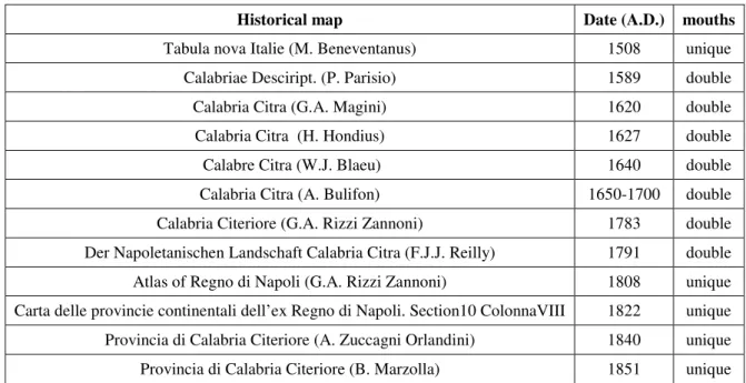
2.3 Historical data
Historical maps allow to observe the space and temporal variations of the hydrographic pattern during the last 400 yr. The Crati and Coscile Rivers had a single mouth up to the beginning of 1500 A.D., during the second half of the 1500 A.D. the two rivers were divided while about in the 1800 A.D. the mouth was again single. Furthermore, the transition from double to single mouth around the 1800 A.D..
Historical map Date (A.D.) mouths
Tabula nova Italie (M. Beneventanus) 1508 unique
Calabriae Desciript. (P. Parisio) 1589 double
Calabria Citra (G.A. Magini) 1620 double
Calabria Citra (H. Hondius) 1627 double
Calabre Citra (W.J. Blaeu) 1640 double
Calabria Citra (A. Bulifon) 1650-1700 double
Calabria Citeriore (G.A. Rizzi Zannoni) 1783 double
Der Napoletanischen Landschaft Calabria Citra (F.J.J. Reilly) 1791 double Atlas of Regno di Napoli (G.A. Rizzi Zannoni) 1808 unique Carta delle provincie continentali dell’ex Regno di Napoli. Section10 ColonnaVIII 1822 unique Provincia di Calabria Citeriore (A. Zuccagni Orlandini) 1840 unique Provincia di Calabria Citeriore (B. Marzolla) 1851 unique
Table 2.1. Information on Crati and Coscile mouths inferred by historical maps
Fig. 2.5. Historical maps of the Sibari Plain: on the left Calabria Citra by C.A.Magini (1602 A.D.) showing two separated mouth for Crati and Coscile Rivers, on the right Regno di Napoli, Section10 ColonnaVIII (1825 A.D.) in
30 Northward from the Crati River, the historical maps show an instable drainage network characterized by streams (e.g., Garda Stream) flowed into the Ionian Sea while currently they are tributaries of the Coscile River. Moreover, the existence of marshes/lagoons northward of Coscile River between Crati and Coriglianeto Rivers is shown.
Crati and Coscile Rivers captures and avulsions can be deducted also by historical reports. In the 710 B.C., the city of Sybaris was founded by the Achaeans between Sybaris and Crathis Rivers (Strabo, VI, 1, 13); in the 510 B.C. after the Traes River battle, Sybaris was destroyed by Crotonians which diverted the Crathis River on the enemy city (Strabo, VI, 1, 13; Diodorus
Siculus, XII, 9, 2; Herodotus, V, 45). A single river mouth existed also in the 413 B.C.
(Thucydides., VII, 35, 1) while in the I century A.D. the two rivers were divided (Plinio il Vecchio, III, 97). Probably, the historical Crathis riverbed migration can be ascribed to natural causes and not to anthropic activity (Guerricchio and Melidoro, 1975; Taliano Grasso, 2004).
Taliano Grasso (2004) highlights, through a discriminating rereading of the historical sources, that
probably the Sybaris and Crathis Rivers mentioned by the historical authors correspond respectively to the present Crati and Coscile Rivers and not conversely.
31
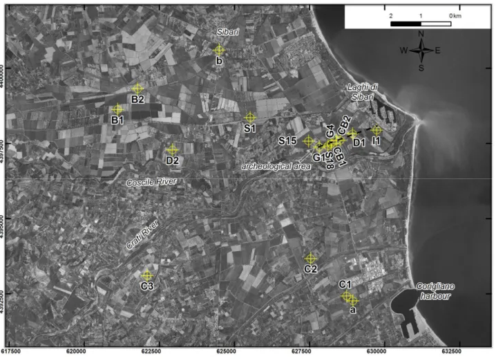
2.4 Well data description and interpretation
The shallow stratigraphic framework of the study area is investigated by well-logs data from bibliographic sources (Guerricchio and Melidoro, 1975; Bellotti et al., 2003; Bernasconi et al., 2010; Cherubini et al., 2000; Demanio Idrico della Provincia di Cosenza; Archivio nazionale delle indagini nel sottosuolo L.464/84; ViDEPI) and inedited (B1 and B2).
Fig. 2.6. Location of the analyzed well-logs. Dashed black line represent the trace of cross-section in fig. 2.7.
During the well-logs analysis, the study area has been divided in three sectors: two sectors respectively northward and southward referring to the present Crati Riverbed and another one between the archeological settlement and the current coastline.
In the sector close to the Sybaris archeological area, the well-logs acquired by scientific papers allow to create a stratigraphic cross section and to recognized four stratigraphic units (fig. 2.7).
32 Fig. 2.7. Stratigraphic cross section of the area between archeological site and present coastline.
The lower unit (1) made by sandy-gravelly deposits with a top surface, dated about 12 kyr B.P. based on S18 well-log carbon dating (Cherubini et al., 2000), characterized by a depth increasing seaward (from 60 to -90m asl). Upward, a thick clayey-silty wedge-shaped body (unit 2) with sandy intercalations is observed. The microfauna analysis available for G1 and G4 well-logs (Guerricchio
and Melidoro, 1975) show the presence of a mainly benthic and planktonic foraminifera association
at about -50m asl and between -20 and -40m asl. The ecobiostratigraphic analysis of CB1 and CB2 (Bernasconi et al., 2010) highlights from -15 to -20m asl molluscan species characteristic of a shallow marine (inner shelf) setting. The top surface of this unit can be dated at about 5 ky B.P. based on carbon dating available for S18 (Cherubini et al., 2000) and CB1 (Bernasconi et al., 2010) well-logs.
Upward, sandy deposits (unit 3) lie on top of clayey-silty body. In G4 well-log (Guerricchio and
Melidoro, 1975) a layer made by coarse grained sand with shallow water molluscan association
(Corbula Gibba and Acteon Tornatilis) is recorded at -20m asl. In CB1 well-logs Bernasconi et al. (2010) recognize from -16.5 to -9 asl a lower molluscan diversity and abundance including
Chamelea gallina, Smaragdia viridis, and Lentidium mediterraneum. In CB2 well-log, the authors
describe, between -16 to -10m asl, a biofacies including Tellina pulchella, C. gallina, L.
mediterraneum, and Donax semistriatus indicating a shallow sandy infralittoral zone.
The sandy layer is overlain by a mainly silty-clayey lithofacies with intercalation peat layers and coarse-grained deposits (unit 4). Toward its top, CB1 and CB2 well-logs (Bernasconi et al., 2010) are characterized, respectively from -9m and -10m asl, by few benthic forams, vegetal components, terrestrial gastropods (Cernuella lineata and Helix ligata), human artefacts and terrestrial vertebrates. In the logs of archeological excavation of Casa Bianca site, Guerricchio and Melidoro
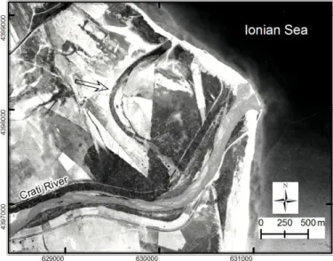
33 (1975) observe a Tamarix gallica tree (dated at 2.33 kyr B.P.) in standing position at -4.5m asl and
Cerastoderma lamarcki shells (0.86 kyr B.P.) at -2.15m asl. Moreover, in Parco del Cavallo area Helix shells (1.595 kyr B.P.) are recorded at 0m asl. Fossil channels are observed in the easternmost
sector where are also clearly visible in air photo (fig. 2.8).
Fig. 2.8. 1954 I.G.M. air photo showing a paleomeander (indicated by the arrow) of Crati River close to the present coastline.
We assign a late Pleistocene age, based on the carbon dating of S18 (Cherubini et al., 2000), to the lower stratigraphic unit. It is interpreted as a mainly coarse-grained coastal plain developed during the late Pleistocene when in the area the sea level was about 140m lower than the present one (Lambeck et al., 2004). Toward the top, this unit probably records both erosion surface and deposits due to the last post-glacial marine ingression. The presence of an erosion surface can partially explain the average sedimentation rate of about 1mm/yr between 29.85 and 11.98 kyr B.P. calculated referring to S18 well-log (Cherubini et al., 2000).
Upward, the faunal and microfaunal assemblages reveal a bluntly marine environment for the over clayey-silty sediments.
The wedge-shaped sandy bodies on the top of marine deposits is interpreted a transitional zone, as suggested by faunal assemblage, which can be referred to a beach ridge system according to Stanley
and Bernasconi and Bernasconi et al. (2010).
The uppermost stratigraphic unit is clearly constituted by continental deposits recognizable by fossiliferous content, plant matter, tree in growing position and human artefacts. We suggest a delta/alluvial plain environment for these deposits.
We analyzed also well-logs located in northern and southern sectors referring to the Crati River, from Sibari village to the Corigliano harbour.
34 Fig. 2.9. Well-logs analyzed in the northern and southern sectors (referring to present Crati riverbed).
The northernmost welllog b (Bellotti et al., 2003) shows a lower stratigraphic unit (from 65 to -75m asl) made by sandy deposits with lens-shaped gravelly bodies passing upward to a 63m-thick clayey deposits with gravelly intercalation toward the top. The succession is closed by 10m-thick sandy-clayey layer. Bellotti et al. (2003) interpreted the lower unit as braided fluvial channel deposits and the top one to a inner delta plain environment while no environmental data are available for the middle clayey layer.
Toward SW, B1 and B2 well-logs (this work) crosses fine-grained (clay, silty-clay and silt) deposits rich of plant materials and peat intercalations (up to -25m asl) with sandy and gravelly layers (thick up to 7.5m).
The S1 well-log (Cherubini et al., 2000), records a lower unit (from -68.5 to -100m asl) consists of sandy and gravelly deposits which pass upward to an alternation of coarse-grained (sand and gravel) and silty-clayey layers. Three peat layers (thick up to 3.5m) are present between -5 and -59m asl and are dated respectively at 9.835, 8.41 and 4.685 kyr B.P..
The D2 well-log (Demanio Idrico office) is characterized, from -30 to -170m asl, by an alternation of dm-thick silty clayey deposits and m-thick gravelly layers. Upward, the succession is made by sandy-silty clay and clay alternated to sandy-gravelly sediments.
Eastward, the S15 (Cherubini et al., 2000) records a lower gravellysandy unit between 61.5 and -71.5m asl passing upward an about 4m-thick sandy-silty layer with peat intercalation. On the top the succession evolves toward sandy sediments (5m thick) following by 20m-thick clayey and siltyclayey deposits with a peat layer at 45m asl. The organic matter dating (Cherubini et al., 2000) at
-35 50m of depth reveals an age of 6310 ky B.P. Upward, 26m-thick sandy layer with gravelly intercalation is overlaid by clay deposits. The latter evolves toward gravelly sediments which pass upward to silty clay and sandy silt.
In the southern sector from the present Crati riverbed, the C3 well-log (Crati 3, ViDEPI) records a gravelly layer from -83 to -1130 m asl, passing upward to an alternation of sand and sandy clay with sporadic clayey and gravelly intercalations.
The C2 well-logs (Crati 2, ViDEPI) shows gravelly and sandy deposits with sporadic clay intercalations from -35 to -140 m asl. Upward, a 20m-thick clayey body with peat intercalation is followed by gravelly sediments.
Southward, the C1 well-log (Crati1, ViDEPI) is characterized by an alternation of sandy and gravelly deposits with intercalation of peat and rare clayey layers.
The southernmost welllog a (Bellotti et al., 2003) records a lower stratigraphic unit (from 58 to -88.5m asl) made by sand with lens-shaped gravelly intercalations. On top, 2m-thick peat layer (dated at 9.9 kyr B.P.) is present and passes upward to a 10m-thick clayey body with lens-shaped gravelly intercalations. Upward, another 2m-thick peat layer is followed by 44m-thick sands with lenticular gravelly bodies and a peat intercalation at -21.5m asl. The logs is closed by a thin (2.5m) sandy-silty layer. Bellotti et al. (2003) interpret the lower coarse-grained unit as a braided fluvial channel depositional element evolving to a coastal barrier lagoon environment. Upward, they suggest another fluvial channel depositional element passes to an inner delta plain.
The well-logs analysis shows clear dissimilarities in the stratigraphic framework between the northern and southern sectors.
In the northern sector, the lower sandy-gravelly unit, related to the late Pleistocene coastal plain depositional element, is overlain (at about -65m asl) by clayey and silty deposits. The latter are characterized by the peat intercalations, from about -60m asl (S15 well-log) with maximum age of 9.835 kyr B.P. (S1 well-log), and widespread plant materials. We suggest that the clayey and silty deposits is related to a wetland area with locally coarse-grained channel-fill and crevasse sediments.
In the southern sector, the stratigraphic pattern is dominated by sands and gravels with widespread peat intercalations. These deposits are related to a coarse-grained coastal-alluvial plain persisting from late Pleistocene to Holocene. The available data do not allow to recognized the deposits related to the post-glacial transgression.
36
2.5 Geoelectrical survey
The good efficiency of the electrical resistivity ground imaging (ERGI) to obtain sedimentological information about the shallow subsurface has been shown by Baines et al. (2002). These authors used successfully ERGI to map the geometry of sand and gravel deposits buried by silt or clay in different field sites; one of these is very similar to the geological context of the Crati Delta and consists of a buried delta distributary channel in the Holocene Rhine–Meuse delta overlapping a Pleistocene sandy-gravelly braid-plain. Froese et al. (2005) investigate the floodplain stratigraphy of middle Yukon River by means of ERGI and GPR, which are employed also by Pellicer and
Gibson (2011) to characterize the internal architecture of Quaternary sediments in the midlands of
Ireland. Kilner et al. (2005) combine resistivity imaging and the electromagnetic induction technique for the characterization of glacial and alluvial Quaternary deposits in Eastern England. ERGI, combining with sedimentological data is also used by Bersezio et al. (2007) to map the fluvial architectural elements in the Quaternary Po Plain. Resistivity imaging has been also used in gravel and sand prospecting, resulting a useful tool (Beresnev et al., 2002; Chambers et al., 2013). In the last decades the electrical resistivity tomography, often associated with other shallow geophysical techniques, have been commonly used for imaging and mapping subsurface active faults (Suzuki et al., 2000; Caputo et al., 2003, 2007; Nguyen et al., 2005, 2007; Improta et al., 2010; Giacoli et al., 2011; Štěpančíková et al., 2011) and also for large scale geological structural studies (Colella et al., 2004).
In this paper the relatively high resistivity contrast between fine- and coarse-grained sediments are used to investigate the boundaries among the different lithofacies deposited during the Holocene evolution of the Crati Delta. Furthermore the electrical resistivity tomographies allow to identify the pre-Holocene bedrock, made up by gravel and sand alluvial plain, and to detect the presence of faults.
2.5.1 Methodology
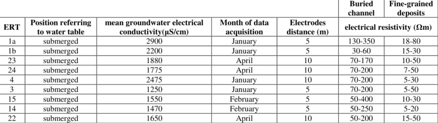
Electrical Resistivity Tomography (ERT) data were collected using a Syscal Pro Resistivity meter with 96, 72 and 48 electrodes using the Schlumberger reciprocal array. Data collected included 9 profile at 5m and 11 profiles at 10m spacing, with 475m of length for each profile except two profile 710m long. ERTs were collected during 5 surveys. The datasets were inverted using RES2DINV software which generates a calculated model of the pseudosection from the inverted model, the Root Mean Square (RMS) error between the calculated and the measured pseudosection is computed.
37
profile electrodes elec. distance(m) length (m) array configuration survey date
1a 96 5 475 Schlumberger reciprocal Rho & IP January 2014 1b 96 5 475 Schlumberger reciprocal Rho & IP January 2014 2 72 10 710 Schlumberger reciprocal Rho & IP November 2012 3 96 5 475 Schlumberger reciprocal Rho & IP January 2014 4 96 5 475 Schlumberger reciprocal Rho & IP January 2014 5 48 10 470 Schlumberger reciprocal Rho & IP November 2012 6 72 10 710 Schlumberger reciprocal Rho & IP November 2012 7 48 10 475 Schlumberger reciprocal Rho & IP April 2014 8 48 10 475 Schlumberger reciprocal Rho & IP April 2014 9 48 10 475 Schlumberger reciprocal Rho & IP April 2014 10 96 5 475 Schlumberger reciprocal Rho & IP February 2014 11 48 10 475 Schlumberger reciprocal Rho & IP April 2014 12 96 5 475 Schlumberger reciprocal Rho & IP February 2014 13 96 5 475 Schlumberger reciprocal Rho & IP February 2014 14 96 5 475 Schlumberger reciprocal Rho & IP February 2014 15 96 5 475 Schlumberger reciprocal Rho & IP February 2014 16 48 10 475 Schlumberger reciprocal Rho & IP April 2014 17 48 10 475 Schlumberger reciprocal Rho & IP April 2014 18 48 10 475 Schlumberger reciprocal Rho & IP April 2014 20 48 10 475 Schlumberger reciprocal Rho & IP April 2014 21 48 10 475 Schlumberger reciprocal Rho & IP April 2014
Table 2.2. General information concerning the realized ERT profiles
Fig. 2.10. Location of the Electrical Resistivity Tomographies realized in the Sibari Plain. In the map are also present the well-logs used to validate ERT interpretation and water wells which allow to detect.
38 Fig. 2.11. Well-logs used to validate the ERTs interpretation (D=Demanio Idrico office; PS=Casmez, 1987). The
remaining well-logs in fig. 2.7.
2.5.2 ERT profiles description
ERT 1a, located in the northwestern sector of the study area, is characterized by low resistivity value (<20Ωm). In the central ERT area (from 160m to 320m) lens-shaped bodies with resistivity between 50 and 400 Ωm are present from surface to depth of 25m. Also in the ERT 1b, represented the southward extension of 1a, the low resistivity values prevail but the high resistivity (>30 Ωm) lens-shaped bodies are bigger and more widespread starting from 30m of depth. The low resistivity values observed in the two ERT represent silty-clay deposits logged by D3 well while the lens-shaped bodies can be related to sandy-gravelly ones.
ERT 2, perpendicular to 1a, is entirely characterized by low resistivity values < 30 Ωm, except two isolated bodies with higher resistivity between 25m and 90m of depth. ERT 4, parallel to 1a and 1b and located about 650m seaward from them, shows in the central area (from 220m to 300m) a body with resistivity between 60 and 300Ωm extended from 90m to 20m of depth. The remaining part of the ERT is characterized by low resistivity values (<30-35Ωm) and lens-shaped bodies with resistivity between 60 and 300Ωm from surface to 20m of depth.
The ERT 3, the easternmost one collected in the Lattughelle locality, runs subparallel to the Crati River. Low resistivity values (<30Ωm) with high resistivity (up to 200 Ωm) lens-shaped bodies are typical of the surface area (reaching 34m of depth). High resistivity layer (>70 Ωm) characterizes the lower area (34-98m) except in the sector between 335m and 380m where low resistivity values prevails. The well CherS15, located 500m eastward, logs gravelly and sandy deposits (high resistivity values in the ERT) separated by 20m-thick clayey layer (low resistivity values). The