UNIVERSITÀ DI BOLOGNA
Dipartimento di Scienze della Terra e Geologico-Ambientali
DOTTORATO IN SCIENZE DELLA TERRA
XXIII CICLO
Coordinatore: Prof. Roberto Barbieri
Settore scientifico-disciplinare di appartenenza
GEO/08
Tesi di Dottorato
PETROLOGY AND GEOCHEMISTRY OF LIPARI ISLAND (AEOLIAN ARCHIPELAGO):
CONSTRAINTS ON MAGMA GENESIS AND EVOLUTION
Presentata da:
Relatore
Dott. Francesca Forni
Prof. C.A. Tranne
Correlatori
Prof. F. Lucchi
Prof. A. Peccerillo
Ai miei genitori
Science, my lad, is made up of mistakes, but they are mistakes, which it is useful to make, because they lead little by little to the truth. Jules Verne
Table of Contents
Abstract...1 Riassunto...2 Structure and aim of the thesis...5 Chapter 1 - Forni F., Lucchi F., Peccerillo A., Tranne C.A., Rossi P.L., Di Martino C.,
Frezzotti M.L. & Ayuso R.A. Lipari. In: Lucchi, F., Peccerillo A., Keller J., Tranne C.A. & Rossi P.L. (Eds.), Geology of the Aeolian Islands (Italy). Geological Society of London, Memoirs, accepted for publication...7
Chapter 2 - Petrogenesis of the mafic to intermediate rocks referred to the Eruptive Epochs 1-6 (270-80 ka)...105 Chapter 3 - Di Martino C., Forni F., Frezzotti M.L., Palmeri R., Webster J.D., Ayuso
R.A., Lucchi F. & Tranne C.A. Anatexis and magma-hybridization in the lower-crust: petrogenesis of cordierite-bearing lavas from Lipari, Aeolian Arc, Italy. Contribution to Mineralogy and Petrology, accepted for publication...141
Chapter 4 - Petrogenesis of the rhyolitic rocks referred to the Eruptive Epochs 7-9 (40 ka-historical times)...193 Chapter 5 - Summary and conclusions...217 Appendix...A1
Abstract
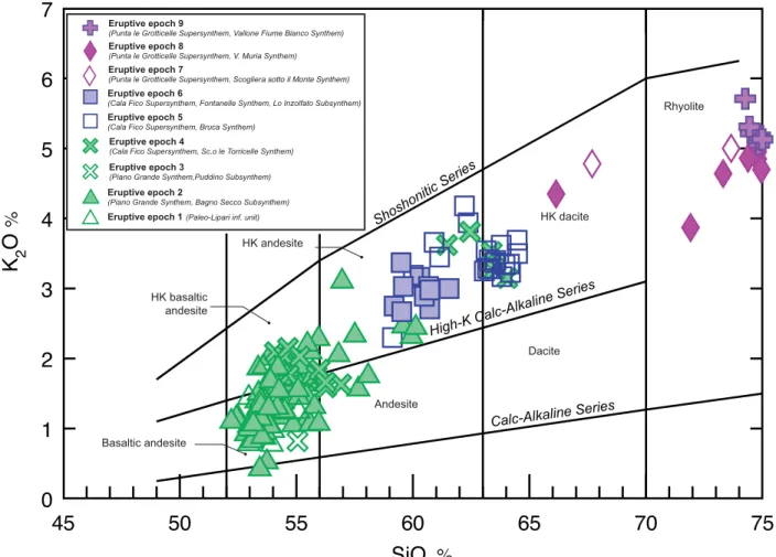
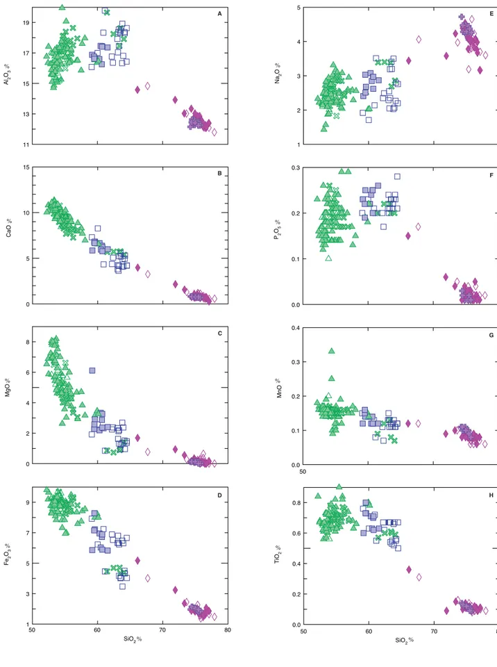
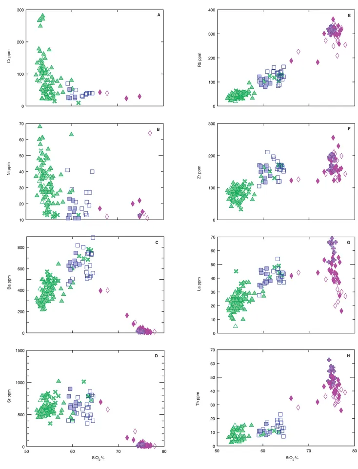
A full set of geochemical and Sr, Nd and Pb isotope data both on bulk-rock and mineral samples is provided for volcanic rocks representative of the whole stratigraphic succession of Lipari Island in the Aeolian archipelago. These data, together with petrographic observations and melt/fluid inclusion investigations from the literature, give outlines on the petrogenesis and evolution of magmas through the magmatic and eruptive history of Lipari. This is the result of nine successive Eruptive Epochs developing between 271 ka and historical times, as derived from recentmost volcanological and stratigraphic studies, combined with available radiometric ages and correlation of tephra layers and marine terrace deposits. These Eruptive Epochs are characterized by distinctive vents partly overlapping in space and time, mostly under control of the main regional tectonic trends (NNW-SSE, N-S and minor E-W). A large variety of lava flows, scoriaceous deposits, lava domes, coulees and pyroclastics are emplaced, ranging in composition through time from calcalkaline (CA) and high-K (HKCA) basaltic andesites to rhyolites. CA and HKCA basaltic andesitic to dacitic magmas were erupted between 271 and 81 ka (Eruptive Epochs 1-6) from volcanic edifices located along the western coast of the island (and subordinately the eastern Monterosa) and the M.Chirica and M.S.Angelo stratocones. These mafic to intermediate magmas mainly evolved through AFC and RAFC processes, involving fractionation of mafic phases, assimilation of wall rocks and mixing with newly injected mafic magmas. Following a 40 ka-long period of volcanic quiescence, the rhyolitic magmas were lately erupted from eruptive vents located in the southern and north-eastern sectors of Lipari between 40 ka and historical times (Eruptive Epochs 7-9). They are suggested to derive from the previous mafic to intermediate melts through AFC processes. During the early phases of rhyolitic magmatism (Eruptive Epochs 7-8), enclaves-rich rocks and banded pumices, ranging in composition from HKCA dacites to low-SiO2 rhyolites were erupted, representing the products of magma mixing between fresh mafic magmas and the fractionated rhyolitic melts.
The interaction of mantle-derived magmas with the crust represents an essential process during the whole magmatic hystory of Lipari, and is responsible for the wide range of observed geochemical and isotopic variations. The crustal contribution was particularly important during the intermediate phases of activity of Lipari when the cordierite-bearing lavas were erupted from the M. S.Angelo volcano (Eruptive Epoch 5, 105 ka). These lavas are interpreted as the result of mixing and subsequent hybridization of mantle-derived magmas, akin to the ones characterizing the older phases of activity of Lipari (Eruptive Epochs 1-4), and crustal anatectic melts derived
from dehydration-melting reactions of metapelites in the lower crust.
A comparison between the adjacent islands of Lipari and Vulcano outlines that their mafic to intermediate magmas seem to be genetically connected and derive from a similar mantle source affected by different degrees of partial melting (and variable extent of crustal assimilation) producing either the CA magmas of Lipari (higher degrees) or the HKCA to SHO magmas of Vulcano (lower degrees). On a regional scale, the most primitive rocks (SiO2<56%, MgO>3.5%) of Lipari, Vulcano, Salina and Filicudi are suggested to derive from a similar MORB-like source, variably metasomatized by aqueous fluids coming from the slab and subordinately by the additions of sediments.
Riassunto
Importanti informazioni riguardo la petrogenesi e l’evoluzione dei magmi che caratterizzano la storia eruttiva dell’isola di Lipari (Arcipelago Eoliano), fra 271 ka e l’attuale, vengono fornite dall’utilizzo congiunto di un set completo di dati geochimici e isotopici (Sr, Nd e Pb) su campioni di roccia e minerali rappresentativi di tutta la successione stratigrafica affiorante e dall’insieme di osservazioni petrografiche e dati di inclusioni fluide e vetrose di letteratura. Sulla base dei più recenti studi stratigrafici e vulcanologici, combinati alle età radiometriche disponibili e a correlazioni basate sull’utilizzo di livelli di tefra noti e terrazzi marini, la storia eruttiva di Lipari è stata definita come il risultato di nove Epoche Eruttive, durante le quali distinti centri vulcanici, controllati dai più importanti lineamenti tettonici regionali (NNW-SSE, N-S e in minor misura E-W), si sovrappongono parzialmente nello spazio e nel tempo. L’attività di questi centri si esplica attraverso la messa in posto di colate laviche, depositi piroclastici, duomi lavici e coulée che variano composizionalmente nel tempo da andesiti basaltiche calcalcaline (CA) e calcalcaline alte in potassio (HKCA) a rioliti. I prodotti da CA e HKCA andesitico-basaltici a HKCA dacitici sono riferiti ad una serie di edifici vulcanici localizzati lungo la costa ovest di Lipari (e subordinatamente nel settore orientale), e agli stratoconi di M.Chirica e M. S.Angelo, attivi nell’insieme a partire da 271 ka fino a 81 ka (Epoche Eruttive 1-6). L’evoluzione di questi magmi da mafici a intermedi avviene principalmente attraverso processi di AFC e RAFC che prevedono il frazionamento delle fasi mafiche in profondità, l’assimilazione delle rocce crostali e il mixing dei magmi residenti con nuovi magmi mafici di provenienza mantellica che entrano in camera magmatica. Nell’isola, successivamente a un periodo di quiescenza dell’attività vulcanica della durata di circa 40 ka, si realizza uno spostamento dell’attività vulcanica, inizialmente nel settore sud (Epoche Eruttive 7 e 8) e successivamente nel
settore nord-est di Lipari (Epoca Eruttiva 9). Durante queste epoche eruttive (da 40 ka fino all’attuale) si ha la messa in posto di grandi volumi di magmi riolitici derivanti dai magmi mafici ed intermedi (simili a quelli eruttati durante le Epoche Eruttive 1-6) attraverso processi di AFC. Particolarmente significativa risulta anche la presenza di enclaves mafici (HKCA andesitici, tachitici e latitici) e pomici bandate in alcuni prodotti riferiti alle Epoche Eruttive 7 e 8, che indica chiaramente la presenza di fenomeni di magma mixing/mingling fra i magmi riolitici (AFC-derivati) e nuovi magmi mafici.
Il processo d’interazione fra magmi di derivazione mantellica e la crosta ha un ruolo essenziale durante tutta la storia magmatica di Lipari ed è ritenuto il principale responsabile delle ampie variazioni geochimiche ed isotopiche osservate nelle vulcaniti oggetto di questo studio. Tale interazione culmina con l’effusione delle lave a cordierite, riferite all’attività eruttiva dello stratocono del M. S.Angelo durante l’Epoca Eruttiva 5 (105 ka) e interpretate come il risultato di mixing e ibridizzazione di magmi di derivazione mantellica (simili a quelli che caratterizzano le Epoche Eruttive 1-4) con magmi anatettico-crostali derivanti da reazioni di dehydration-melting di rocce metapelitiche nella bassa crosta.
Una comparazione fra le adiacenti isole di Lipari e Vulcano evidenzia che le rocce da mafiche ad intermedie a diverso contenuto in K2O, che caratterizzano due periodi di attività distinti nelle due isole (270-116 ka a Lipari e 120-30 ka Vulcano) potrebbero derivare da sorgenti mantelliche simili affette da un diverso grado di fusione parziale (e vario contributo dell’assimilazione crostale). Un basso grado di fusione parziale è suggerito per i magmi da HKCA a shoshonitici (SHO) di Vulcano, mentre un più alto grado di fusione parziale potrebbe aver dato origine ai magmi CA di Lipari. Inoltre, a scala regionale, le rocce più primitive (SiO2 <56%, MgO >3.5%) di Lipari, Vulcano, Salina e Filicudi potrebbero derivare da una sorgente magmatica simile (sorgente MORB-like), variabilmente metasomatizzata da fluidi provenienti dallo slab, e in minor misura dalla addizione di sedimenti.
Structure and aim of the thesis
The aim of this PhD thesis is to supply a complete petrogenetic model of the magmatic evolution of Lipari Island on the basis of a petrological, geochemical and isotopic study in the light of recentmost volcanological and stratigraphic reconstructions.
The manuscript is structured as a collection of two papers (Chapters 1 and 3) and a geological map (cf. attached CD) submitted to international journals and accepted for publication, two thematic chapters (Chapters 2 and 4) and the final conclusions (Chapter 5).
In Chapter 1 (Forni F., Lucchi F., Peccerillo A., Tranne C.A., Rossi P.L., Di Martino C., Frezzotti M.L. & Ayuso R.A. Lipari. In: Lucchi, F., Peccerillo A., Keller J., Tranne C.A. & Rossi P.L. (Eds.), Geology of the Aeolian Islands (Italy). Geological Society of London, Memoirs, accepted for publication) the authors provide a complete outline of the stratigraphic evolution of Lipari and a new geological map of the island (Lucchi F., Tranne C.A., Forni, F. & Rossi, P.L. Geological map of Lipari Island, scale 1:10,000 (Aeolian archipelago), in: Lucchi F., Peccerillo A., Keller J., Tranne C.A. & Rossi P.L. (Eds.), Geology of the Aeolian Islands (Italy), Geological Society of London, Memoirs, accepted for publication; cf. enclosed CD). Moreover, they present a full set of original major and trace element data covering the whole stratigraphic succession of Lipari. Combined with isotopic analyses and melt and fluid inclusions data from the literature, the resulting data-set provide an up-to-date review about the petrogenesis of the magmatic rocks of Lipari and the structure and evolution of its plumbing system.
Chapter 2 is the advanced proof of a paper in preparation and is focused on the petrogenesis of the mafic to intermediate rocks referred to the older to intermediate phases of activity of Lipari (270-80 ka). The role of mantle sources and evolutionary processes at Lipari, and the relationships with the nearby island of Vulcano and with the other islands of the Aeolian archipelago are discussed on the basis of new geochemical, isotope (Sr, Nd and Pb) and mineral chemistry data representative of the stratigraphic interval of interest.
Chapter 3 (Di Martino C., Forni F., Frezzotti M.L., Palmeri R., Webster J.D., Ayuso R.A., Lucchi F. & Tranne C.A. Anatexis and magma-hybridization in the lower-crust: petrogenesis of cordierite-bearing lavas from Lipari, Aeolian Arc, Italy. Contribution to Mineralogy and Petrology, accepted for publication) is focused on the petrogenesis of the cordierite-bearing lavas erupted from the M. S.Angelo volcano during the intermediate activity of Lipari (105 ka). The eruption of these peculiar lavas, characterized by the coexistence of typical igneous minerals along with cordierite, garnet and a huge amount of magmatic and metamorphic xenoliths, marks a turning
point in the magmatic evolution of Lipari. Therefore, a detailed study of these rocks represents a fundamental step in the reconstruction of the magmatic evolution of Lipari. The study is based on petrography, glass and mineral chemistry data, together with the substantial contribution of Sr and Nd isotope data obtained both on whole-rock and mineral samples.
Chapter 4 is aimed at unravelling the petrogenesis of rhyolitic rocks referred to the youngest activity of Lipari (40 ka-historical times). A new set of geochemical, isotope (Sr, Nd and Pb) and mineral chemistry data is presented and discussed in order to examine the evolutionary processes leading to the genesis of the sialic melts and their relationships with the older magmatism of Lipari (cf. Chapter 2). The origin of sialic melts at Lipari (but also at Vulcano, Salina and Panarea) represents one of the most interesting petrogenetic problems concerning the magmatic evolution of the single islands and of the entire Aeolian archipelago. Thus, this subject hints at further investigations.
CHAPTER 1
Forni F., Lucchi F., Peccerillo A., Tranne C.A., Rossi P.L., Di
Martino C., Frezzotti M.L. & Ayuso R.A. Lipari. In: Lucchi,
F., Peccerillo A., Keller J., Tranne C.A. & Rossi P.L. (Eds.),
Geology of the Aeolian Islands (Italy). Geological Society of
LIPARI
12
FORNI F.(1),LUCCHI F.(1),PECCERILLO A.(2),TRANNE C.A.(1),ROSSI P.L.(1),DI
3
MARTINO C.(1),FREZZOTTI M.L.(3),AYUSO R.A.(4)
4 5
(1) Department of Earth and Geological-Environmental Sciences, University of Bologna,
6
Piazza Porta S.Donato 1, 40126 Bologna, Italy.
7
(2) Department of Earth Sciences, University of Perugia, Piazza Università 1, 06100 Perugia,
8
Italy.
9
(3) Department of Earth Sciences, University of Siena, Via Laterina 8, 53100 Siena, Italy.
10
(4) U.S. Geological Survey, Mail Stop 954, National Center Reston, 20192 Virginia, USA.
11 12
Abstract
13
The Lipari volcano, situated in the central Aeolian sector, is constructed between 271 ka
14
and historical times through the emplacement of various lava flows, scoriaceous deposits,
15
lava domes (coulees) and pyroclastics related to hydromagmatic and strombolian activities.
16
The eruptive history of Lipari is described by nine successive Eruptive Epochs interrupted by
17
dormant periods, volcano-tectonic phases and episodes of terrace formation during the last
18
interglacial. Several (partially overlapping) volcanic edifices are active through time mostly
19
under control of the NNW-SSE and N-S (minor E-W) regional tectonic trends. The latest
20
eruptive events at M. Pilato and Rocche Rosse occurred in AD 776 to 1230.
21
Lipari rocks widely range in composition from calcalkaline and high-K basaltic andesites
22
and andesites (from 271 to 81 ka) to rhyolites (<42 ka), with minor dacites. There is a clear
23
increase of K2O and incompatible elements through time, with distinct trends for mafic-24
intermediate and sialic rocks. Sr, Nd, and Pb isotopes are highly variable and cover almost
25
the whole range of isotopic compositions of the Aeolian archipelago. Petrographic and
26
geochemical data suggest AFC and mixing evolution processes, with a localized important
27
influence of crustal anatexis, in the context of a polybaric feeding system.
28 29
Key words
30
Lipari, Marine terraces, Unconformity-bounded Units, Eruptive history, Petrogenesis
31 32 33 34 35 36
Introduction
37
Lipari is the largest of the Aeolian Islands, located in a strategic position in the central
38
sector of the archipelago along the Tindari-Letojanni structural system. It developed entirely
39
during the late Quaternary between 270 ka BP and hystorical times, and presently behaves
40
in a quiescent stage of activity with a few low temperature fumaroles (along the western and
41
central-southern sectors) and hot springs (in the western sector, at Bagni termali di San
42
Calogero and Bagno Secco). Geological fieldwork and stratigraphic analysis carried out
43
during the nineties, combined with previous data and radiometric ages from the literature
44
(Bigazzi and Bonadonna, 1973; Pichler, 1980; Crisci et al., 1981, 1983; Gillot, 1987; Losito,
45
1989; Crisci et al., 1991; De Rosa et al., 2003b; Tanguy et al., 2003; Lucchi et al., 2004a),
46
have resulted in a geological map of Lipari elaborated by primarily following the
47
unconformity-bounded criteria (Tranne et al., 2002; Lucchi et al., 2004b; Lucchi et al., 2010).
48
What we present here is an updated 1:10,000 scale version of Lipari’s map based on recent
49
radiometric ages (Leocat et al., 2009; Leocat et al., 2010) and new stratigraphic investigation
50
performed in the course of ongoing geological mapping of sheet Nos. 577 bis – “Isole di
51
Stromboli e Panarea”, 580 bis – “Isole di Alicudi e Filicudi”, and 581/586 – “Isole di Salina,
52
Lipari e Vulcano” as part of the Geological Mapping of Italy - 1:50.000 project (CARG
53
Project). The main purpose of this paper is to provide an accurate description of
54
stratigraphical, morphologic, structural and petrochemical features of volcanic rocks building
55
up the articulated stratigraphic succession of Lipari Island, which consists of lava flows,
56
scoriaceous deposits, lava domes and widespread hydromagmatic pyroclastic products,
57
originated from several eruptive vents partly overlapping in space (and time) under control of
58
major tectonic trends. Note that Lipari is the site of explosive eruptions with the highest
59
intensity and magnitude across the entire Aeolian archipelago (i.e., M.Guardia, Vallone del
60
Gabellotto, M.Pilato pyroclastic products).
61
For the great variety of rock types and the complexity of its stratigraphy, the
late-62
Quaternary Lipari Island represents a useful case study for the application of a stratigraphic
63
methodology to fieldwork and mapping in volcanic areas based on the adoption of
64
unconformity-bounded units (UBUs), together with more descriptive lithosomes and
65
lithostratigraphic units (see Lucchi and Tranne, 2011). We aim to show that UBUs can
66
provide effective tools of correlation and a practical and clear approach to stratigraphic
67
analysis at Lipari, by subdividing the volcanic succession through unconformities with a clear
68
field evidence on a large scale and a strong relative chronostratigraphic significance.
69
Particular attention is given to the late-Quaternary terraced marine deposits diffusely
70
reported along the western coastal slopes of Lipari Island, resulting from the interaction
71
between recurrent sea-level fluctuations during the last interglacial and continuous crustal
72
uplifting. Together with major tephra layers, the terrace deposits are used as powerful
stratigraphic means of correlation and relative dating at Lipari as well as fundamental
74
stratigraphic constraints for the geological evolution of the entire Aeolian archipelago. This
75
approach is able to provide an effective stratigraphic synthesis of the geological evolution
76
and eruptive history of Lipari, as the result of volcanic activity of local and external
77
provenance, sea-level fluctuations and tectonics. In particular, the compilation of
78
stratigraphic, volcanological and structural data provides a detailed stratigraphic outline of
79
Lipari and a accurate perspective on the relations between volcanism, regional tectonic
80
trends and volcano-tectonic structures through time. This has a fundamental outcome
81
towards the evaluation of volcanic hazard of active or recent volcanoes, which is the case of
82
Lipari where latest eruptive events are dated back at AD 776-1238.
83
Moreover, this paper makes available a set of new petrological, geochemical and
melt-84
inclusion data, which, combined with isotopical data from the literature (Crisci et al., 1991;
85
Esperanca et al., 1992; Gioncada et al., 2003; Gioncada et al., 2005), can provide an
up-to-86
date petrogenetic model of Lipari’s magmatism according to the most recent volcanological
87
and stratigraphical reconstruction. On this subject, it is to be noticed that Lipari is
88
characterized by a wide compositional range of erupted products from calcalkaline (CA)
89
basaltic andesites to high-K rhyolites, with a steep increase in K2O through time from mafic to 90
silicic rocks (which is common to most of the Aeolian islands), a notable gap in the field of
91
dacites, and late appearance of rhyolite products after a prolonged period of quiescence.
92
These are long-debated aspects of Lipari’s magmatism and have been related either to
93
heterogeneities in the mantle source, the effect of different magmatic differentiation
94
processes or the influence of regional tectonic trends. Our aim here is to give a contribution
95
towards the reconstruction of the magmatic history of Lipari prior to eruption, particulary
96
regarding the nature of magma sources and the role of magma differentiation processes.
97 98
Site and morphostructural setting
99
The Lipari Island (38 km2 - 602 meters asl at M. Chirica) is the subaerial portion of a broad 100
volcanic edifice rising ~1000 m from the sea floor in the central portion of a largely
101
submerged volcanic belt that includes also Vulcano and Salina volcanoes (Fig. 1). This
102
volcanic belt transversely intersects the arc-shaped structure of the Aeolian archipelago
103
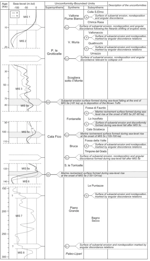
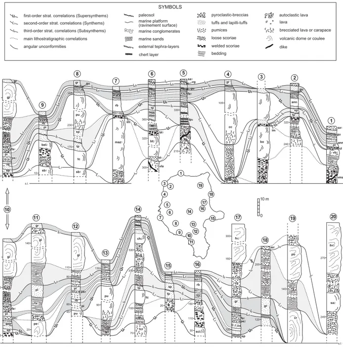
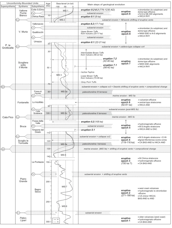
striking along the NNW-SSE direction of the major Tindari-Letojanni fault system (Mazzuoli et
104
al., 1995; Continiso et al., 1997; Lanzafame and Bousquet, 1997; Ventura, 2011). Both
105
subaerial and submerged portion of Lipari volcano are directly controlled by the
Tindari-106
Letojanni fault system, which is responsible for alignment of active eruptive centres, changes
107
of eruptive styles, and, in general, magma genesis and evolution. The Tindari-Letojanni fault
108
system is primarily demonstrated by the occurrence of NNW-SSE strike-slip to transtensional
109
faults with metric to decametric dip-slip along the south-western coast of Lipari (Fig. 2). Major
fault scarps give rise to 100-m-high subvertical cliffs and triangular to trapezoidal facets
111
along the south-western coastline nearby Scogliera sotto il Monte (Mazzuoli et al., 1995).
112
Minor N-S to NE-SW trending normal faults are also reported in distinct sectors of the island
113
(Mazzuoli et al., 1995; Ventura et al., 1999). Mazzuoli et al. (1995) suggest that these
114
extensional fractures are more likely kinematically compatible with the major NNW-SSE
115
shear zone, splaying out from the major strike-slip structures. The influence of regional fault
116
systems is moreover outlined by the intense hydrotermalization of volcanic rocks in
117
correspondence of a wide strip affected by NNW-SSE to N-S tectonic lineaments along the
118
western coast of Lipari from Timpone Carrubbo, to the south, to Pietrovito, to the north
119
(Decrée et al., 2005). The NNW-SSE and N-S striking faults are supposed to have
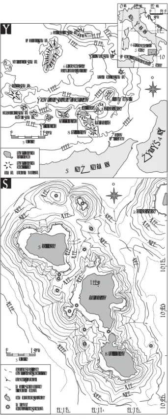
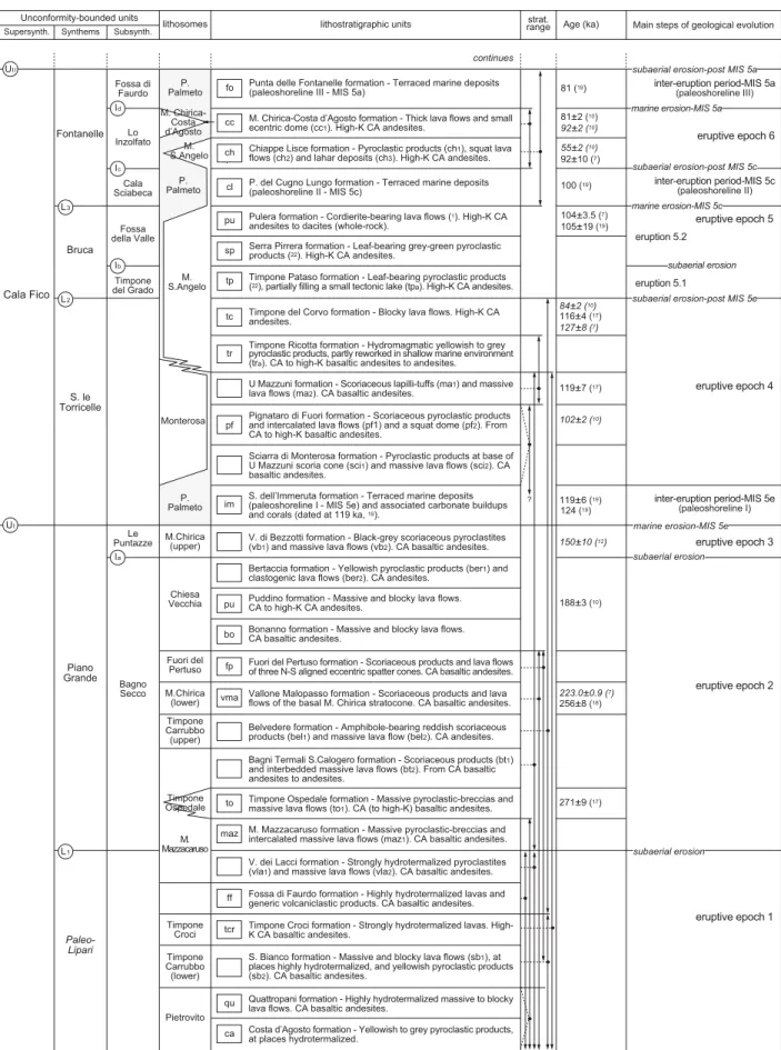
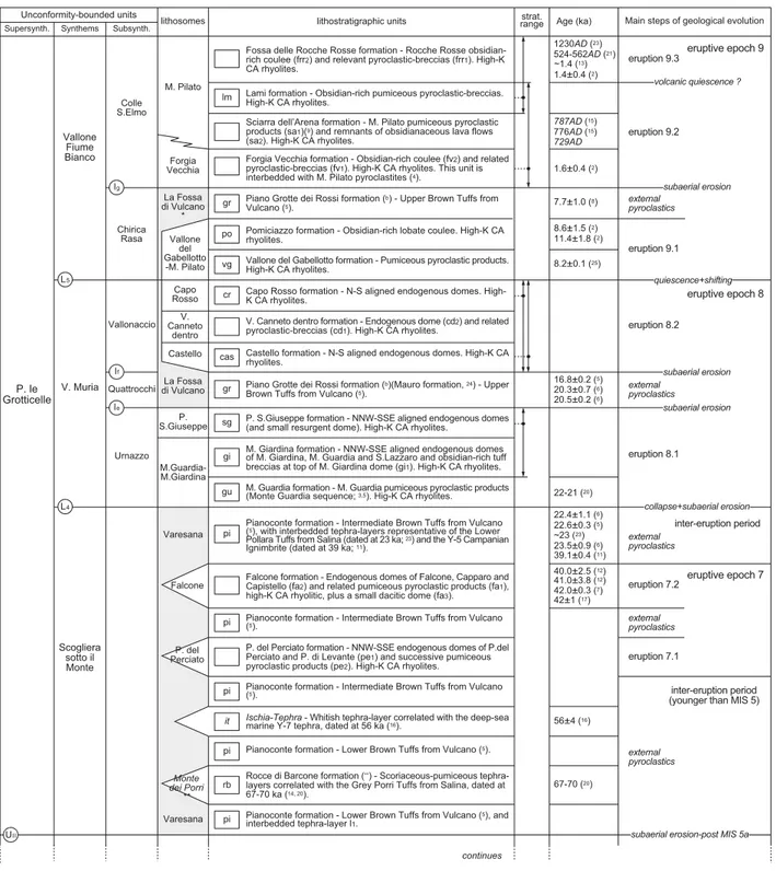
120
conditioned ponding and ascent of magmas responsible of Lipari’s volcanism (De Astis et al.,
121
2003), which is particularly shown by the alignment of eruptive vents in N-S to NNW-SSE
122
directions through the entire geological history of Lipari. A minor E-W-oriented extensional
123
tectonic trend is demonstrated by the aligned scoria cones of Monterosa, along the eastern
124
coast of Lipari.
125
Accurate morphostratigraphic investigation has allowed identification of distinct
volcano-126
tectonic structures outlined by subvertical escarpments with curved geometry (Fig. 2), which
127
are invariably marked by the high-angle discordance relations between pre-collapse and
128
collapse-filling volcanic products. Overall, major caldera-type volcano-tectonic collapses on
129
Lipari are represented by (in stratigraphic order):
130
• vc1) 700-m-large collapse structure reconstructed in the area of
Quattropani-131
Pietrovito, northern Lipari;
132
• vc2) 1.3 km-large, elliptical N-S-elongated morphologic depression rim outlined by
133
evident morphological slope breaks under the cover of younger volcanic products
134
between the M. S.Angelo and M. Chirica topographic reliefs. This apparently
135
demonstrates the occurrence of a buried caldera-type collapse structure. A similar
136
structure is also possibly documented along the western coastal sector of Lipari,
137
nearby Timpone Ricotta.
138
• vc3) semi-circular collapse rim exposed nearby Quattrocchi, at the northern border
139
of the large dome field occupying the southern sector of Lipari Island. Based on
140
structural and geophysical data, Ventura et al. (1999) suggest that this collapse
141
structure is the northern counterpart of the older stages of development of La
142
Fossa caldera structure on Vulcano Island, both bounding a wide basin-like
143
structure. This is apparently confirmed by our structural and stratigraphic analysis
144
showing that collapse vc3 on Lipari and the older collapse rims of the multi-stage
145
La Fossa caldera structure on Vulcano both developed at around 100 ka BP.
• vc4) semi-circular collapse rims observed in the southern sector of Lipari, nearby
147
Falcone-Capistello.
148
Mazzuoli et al. (1995) suggest that regional N-S to NE-SW trending extensional structures
149
had a primary influence on the development of major collapse structures. Conversely, our
150
morphostratigraphic analysis demonstrates that collpase structures have an evident curved
151
geometry that apparently indicates a volcano-tectonic or volcano-related origin. The
152
possibility that major volcano-tectonic collapses on Lipari are the surficial expression of
153
caldera-type structures cannot thus be discounted. If this is the case, similarly to what
154
assumed for Vulcano Island, collapse structures may result from recurrent subsidence
155
processes induced by the extraction of magma from shallow magma reservoirs, which is
156
compatible with the observed absence of caldera-forming pyroclastic products.
157
Terraced marine deposits and a few marine notches, together with numerous carbonate
158
buildups, are reported along the entire western of Lipari Island, and in a few places along the
159
eastern coast, at elevations ranging between 45 m and a few metres above sea level (asl).
160
(Fig. 3A, B). Due to diffuse cover of younger continental detrital deposits and volcanics,
161
marine features are best exposed along the steep coastal cliffs, repeatedly interbedded with
162
successive volcanic products related to the western volcanoes. Terraced deposits
163
correspond to paleoshorelines I (43-45 m asl), II (23-27 m asl), III (~12 m asl), which are
164
attributed to the interglacial sea-level peaks of MIS 5e (124 ka), MIS 5c (100 ka) and MIS 5a
165
(81 ka), respectively, on the basis of cross-cutting relations, stratigraphic constraints and
166
radiometric ages of volcanic products (Fig. 3C; Calanchi et al., 2002, Lucchi et al., 2004a).
167
This relative chronological attribution is confirmed by the U/Th age of Cladocora caespitosa
168
corals related to paleoshoreline I (119±6 ka; Calanchi et al., 2002). The staircase of
169
paleoshorelines has not a complete outcrop exposure in any part of the island owing to
170
subsequent erosional processes or located tectonic instability, but their correlation is founded
171
on their sub-horizontal distribution and widespread dispersion of paleoshoreline II terraces.
172
Paleoshorelines I, II and III are invariably arranged in a downstepping stacking pattern with
173
older terraces placed at higher elevations (Fig. 3B; Lucchi, 2009). This setting accounts for
174
the long-term effect of continuous crustal uplift (mean rate of ~0.34 m/ka from the last
175
interglacial; Calanchi et al., 2002; Lucchi et al., 2004a) superposed to recurrent
glacio-176
eustatic sea-level fluctuations.
177 178
Geology and mapping
179 180
Literature review
• Dolomieu (1783), Cortese and Sabatini (1892), Bergeat (1899), Keller (1967), Pichler
182
(1968), Barberi et al. (1974) gave general information about the Lipari Island, which
183
has long known for to its exceptional variety of lithological and petrochemical rock
184
types and its strategic position in the middle of the Aeolian archipelago.
185
• The first systematic geological map at a 1:10.000 scale was drawn by Pichler (1976;
186
1980), who performed a subdivision of Lipari’s volcanic activity in four successive
187
periods ranging in time from the early Tyrrhenian to the Late Roman age, on the basis
188
of Pleistocene eustatic coast-lines, and age determinations using 14C and fission track 189
methods. The Pichler’s map provided a generic lithological and volcanological
190
characterization of rocks with a thorough field description and interpretation mostly
191
limited to their petrochemical attitude, which ranges from quartz-andesites to alkali
192
feldspar rhyolites belonging to a typical calcalkaline series.
193
• Largely based on Pichler’s stratigraphy, Crisci et al. (1991) developed, as a tool for
194
their petrochemical studies, a chrono-stratigraphic framework subdivided into ten
195
cycles of volcanic activity separated by chronological gaps, stratigraphic
196
unconformities and compositional changes.
197
• Several petrological and volcanological studies (Crisci et al., 1981, 1983; De Rosa
198
and Sheridan, 1983; Cortese et al., 1986; Sheridan et al., 1987; Esperanca et al.,
199
1992; Gioncada et al., 2003, 2005: Davì et al., 2008, 2009), mostly based on the were
200
the map and stratigraphy of Pichler (1976; 1980) and its implementation by Crisci et
201
al. (1991), have been performed with the aim of investigating the magmatic and
202
eruptive history of Lipari, particularly regarding its most recent volcanic rocks.
203 204
Chronostratigraphic framework
205
The age of Lipari's volcanic rocks is shown to range from 270 ka BP to historical times, as
206
derived by geological fieldwork and stratigraphic analysis combined with several radiometric
207
age determinations obtained with K/Ar (Gillot, 1987; Crisci et al., 1991; De Rosa et al.,
208
2003b; Leocat et al., 2009), Ar/Ar (Lucchi, 2000; Lucchi et al., 2004a), 14C (Crisci et al., 1981, 209
1983; Losito, 1989; Pichler, 1980), fission track (Bigazzi and Bonadonna, 1973) and
210
archeomagnetic (Tanguy et al., 2003) methods. Further relative age assignments are
211
provided by the correlation of terraced marine deposits formed during the interglacial
sea-212
level peaks of MIS 5e (124 ka), MIS 5c (100 ka) and MIS 5a (81 ka). These marine deposits
213
are repeatedly interlayered with volcanic rocks mostly along the western coast of Lipari
214
(Calanchi et al., 2002; Lucchi et al., 2004a), and act as fundamental time-stratigraphic
215
markers for the reconstruction of its geological evolution. Moreover, numerous
216
chronostratigraphic attributions are established by means of accurate tephrostratigraphy. The
217
stratigraphic record of Lipari is in fact characterized by the occurrence of several prominent
tephra layers represented by large-scale, primary air-fall deposits of inter-island and external
219
provenance (Lucchi et al., 2008; Lucchi et al., 2011). The Campanian tephra layers are
220
represented by the Ischia Tephra (56 ka) and by the probable occurrence of the deep-sea
221
marine Y-5 tephra layer (39 ka) correlated with the Campanian Ignimbrite (Lucchi et al.,
222
2011). The inter-island tephra layers are instead originated by explosive eruptions of Aeolian
223
volcanoes. They include the Grey Porri Tuffs (67-70 ka) and Lower Pollara Tuffs (~23 ka)
224
from Salina Island and the Lower (<70-56 ka), Intermediate (56-22 ka) and Upper Brown
225
Tuffs (21-7 ka) from Vulcano Island, these latter representing the most prominent pyroclastic
226
succession over the entire Aeolian archipelago (Lucchi et al., 2008). Main characters of
227
recognized tephra layers are summarized in Table 1.
228 229
Unconformity-bounded stratigraphic succession
230
The stratigraphic framework of Lipari Island is described in terms of 21
unconformity-231
bounded units (UBUs) and the informal Paleo-Lipari unit, which are bounded by several
232
unconformities with variable duration and distribution (Fig. 4; Table 2). Major rank
233
discontinuities are the the large-scale allogenic unconformities UI and UII (Fig. 4), which 234
stratotype has been defined on Lipari (Lucchi, 2009; Lucchi et al., 2011). Unconformity UI is 235
the surface of marine ravinement bounding at base MIS 5 marine deposits and formed during
236
sea-level rise at the onset of MIS 5e. Instead, unconformity UII is found at top of MIS 5 237
marine deposits and corresponds to the subaerial unconformity developed during sea-level
238
fall and lowstand and the end of MIS 5a. Unconformity UII is notably covered along its whole 239
lateral extension by the Brown Tuffs pyroclastics originated from Vulcano Island (Lucchi et
240
al., 2008; Lucchi et al., 2011). Based on widespread recognition of Brown Tuffs and MIS 5
241
terraced marine deposits, unconformities UI and UII are correlated across most of the Aeolian 242
archipelago, thus assuming a first-order rank (Lucchi, 2009). They allow designation of two
243
major UBUs, namely the Cala Fico and Punta le Grotticelle Supersynthems, which were first
244
introduced on Lipari (Tranne et al., 2002) and then extended to the rest of the archipelago.
245
The Cala Fico Supersynthem includes alternating terraced marine deposits and volcanic
246
products emplaced during the time interval corresponding to the last interglacial (=MIS 5,
247
between 124 and 81 ka). The Punta le Grotticelle Supersynthem is entirely composed of
248
volcanics formed during the long time interval spanning from the end of MIS 5a (<81 ka) to
249
historical times, together with coeval pyroclastics of external provenance. By means of
250
introduction of second-order unconformities L1-L5 and third-order unconformity la-lg, the Cala 251
Fico and Punta le Grotticelle Supersynthems are furtherly subdivided into seven synthems
252
(Piano Grande, Sc.° le Torricelle, Bruca, Fontanelle, Scogliera sotto il Monte, V. Muria,
253
Vallone Fiume Bianco), twelve subsynthems and the Paleo-Lipari informal unit, the latter
254
including volcanic rocks which bottom unconformity does not occur (Fig. 4). These
rank unconformities are represented either by allogenic unconformities developed during
256
recurrent sea-level oscillations in the course of MIS 5 (i.e., L3, lc, ld), or by autogenic 257
unconformities formed during major quiescent stages (i.e., L1, L2, L4, L5, la, lb, le, lf, lg). The 258
latter are represented by surfaces of subaerial erosion, angular discordance and/or
259
paleosols, and are frequently associated with volcano-tectonic collapse events, shifting of
260
eruptive vents and remarkable change of conposition of erupted products. Description and
261
intepretation of bounding unconformities are summarized in Table 2, with areal distribution of
262
main UBUs shown in Fig. 5. The UBUs build up an overall synthetic stratigraphic framework
263
of classification and correlation on a scale from local to regional, which includes several
264
lithosomes, formations and members for descriptive purposes (Fig. 6). A series of volcanic
265
lithosomes are introduced to define 22 main eruptive vents on Lipari, which correspond either
266
to large stratocones (i.e., Timpone Carrubbo, Monte Mazzacaruso, Monte Chirica, Chiesa
267
Vecchia, Monterosa, Monte S.Angelo lithosomes) or to monogenetic scoria cones or tuff
268
cones and related lava flows or domes (i.e., Timpone Croci, Pietrovito, Monte Chirica-Costa
269
d’Agosto, Vallone del Gabellotto-Monte Pilato, Forgia Vecchia and M. Pilato lithosomes),
270
aligned spatter cones or domes (i.e., Timpone Ospedale, P. del Perciato, Falcone,
271
M.Guardia-M.Giardina, P. S.Giuseppe, Castello, V.ne Canneto dentro, Capo Rosso).
272
Moreover, a few external volcanic source areas have been identified on Vulcano (i.e.,
273
Varesana and La Fossa di Vulcano lirthosomes) and Salina islands (i.e., Monte dei Porri
274
lithosome). Non-volcanic lithosomes are introduced to identify the marine terraces formed
275
during MIS 5 (i.e., Palmeto lithosome). The lithostratigraphic units, adopted in integration with
276
lithosomes (Lucchi and Tranne, 2011), give a description of main lithological properties and
277
petrochemical features of Lipari’s rocks, which are summarized in Table 3. Eruption types
278
and emplacement mechanisms are inferred by interpreting the lithostratigraphic units in
279
terms of distinct eruption units (sensu Fisher and Schmincke, 1984; cf. Lucchi et al., 2011,
280 for a review). 281 282
Eruptive history
283Based on the reconstructed unconformity-bounded stratigraphy, the eruptive history of
284
Lipari Island developing between 270 ka BP and historical times is the result of nine
285
successive Eruptive Epochs (furtherly subdivided into distinct eruptions), separated by
inter-286
eruption intervals of quiescence of varying duration and character (see Fisher and
287
Schmincke, 1984; Lucchi and Tranne, 2011 for a review of the adopted methodology).
288
Eruptive Epochs (and Eruptions) and inter-eruption periods are hereafter listed according to
289
the corresponding UBUs (Fig. 5 and 6). They are described in terms of active eruptive vents
290
(using lithosomes) and physical characteristics of erupted products (using lithostratigraphic
291
units). In fact, eruptive activity through time is characterized by distinctive localization and
type of eruptive vents, chemical composition of erupted products and eruption types. The
293
periods between eruptions are characterized by variable degrees of subaerial erosion of the
294
volcanic reliefs, and are associated with development of several volcano-tectonic collapses
295
(namely vc1, vc2, vc3, vc4). Erosion and reworking of volcanic reliefs were mostly driven by
296
the sea-level oscillations occurred during MIS 5, which lead to development of successive
297
marine terraces.
298 299
Eruptive Epoch 1: older volcanoes (i.e., Paleo-Lipari informal unit)
300
The oldest exposed Paleo-Lipari volcanic products are represented by lava flows and
301
pyroclastics (minor scoriae) building up a series of isolated volcanoes along the west coast of
302
Lipari (Pietrovito, Timpone Carrubbo, M. Mazzacaruso; Fig. 5) and very subordinately in its
303
central sector (Timpone Croci). Volcanism was of central-type, generally with initial
304
hydromagmatic explosive phases of activity driving the generation of multiple dilute
305
pyroclastic density currents (PDC) followed by the effusion (prevalent) of lava flows and
306
minor strombolian fallout processes. This pattern reflects the interaction between magmas
307
and external sea-water in very shallow water conditions and the progressive transition from
308
hydromagmatic to magmatic (strombolian and effusive) phases of activity during the
309
progressive building of a volcanic island (cf. Schmidt and Schmincke, 2000).
310
The remnants of Pietrovito volcano are presently found on the sides of caldera-type
311
collapse vc1, in the area of Quattropani (NW Lipari), which is interpreted to have dissected
312
its summit. Yellowish to grey, plane-parallel stratified, hydromagmatic lapilli-tuffs crop out at
313
an oblique angle to the slope of Quattropani-Costa d’Agosto (i.e., Costa d’Agosto formation),
314
representing the eastern flank of a tuff cone structure. Massive and blocky lava flows (i.e.,
315
Quattropani formation) are instead exposed on the western side of collapse vc1, accounting
316
for the effusive phases of activity of the Pietrovito volcano.
317
The lower (and main) portion of the Timpone Carrubbo volcano is represented by a
318
~180m high stratocone made up of massive and blocky lava flows and interbedded
319
strombolian fallout scoriaceous deposits (i.e., Sc.o Bianco formation, sb
1 member), exposed 320
in the SW coastal sector between Spiaggia Valle Muria and Punta delle Fontanelle (Figs. 5
321
and 7A). Yellowish planar- to cross-stratified pyroclastics are interbedded (sb2 member), 322
reflecting the occurrence of intense hydromagmatic phases of activity giving rise to a series
323
of dilute PDC eruption units. The inner part of this volcano with several subvertical feeding
324
dykes is presently exposed near to P. le Grotticelle due to prolonged marine erosion and cliff
325
retreat.
326
The M. Mazzacaruso compound volcano, in the central-western sector of Lipari, is largely
327
constructed during Eruptive Epoch 1. The initial hydromagmatic (and minor strombolian)
328
explosive phases of activity lead to development of a 70m high and 200m large tuff ring-type
structure (V.ne dei Lacci formation, vla1 member), which was lately filled and covered by 330
several massive and blocky lava flows (vla2 member) that determined the growth of the 331
volcano up to elevations of ~300 metres.
332
Overall, these products are homogeneously CA basaltic andesites, which represent the
333
most primitive rock types on Lipari. They are diffusely characterized by very intense
334
hydrotermalization and are largely dismantled, which frequently leads to the development of
335
brecciated, kaolin-rich deposits with only a few remnants of the original volcanic lithotypes
336
(e.g., at Timpone Carrubbo, Bagno Secco). For example, the strongly hydrotermalized lavas
337
constituting the Timpone Croci relief nearby the Lipari village (i.e., Timpone Croci formation)
338
are only generically suggested to represent the remnants of a lava cone, mostly due to
339
morphological features. Moreover, the Fossa di Faurdo formation includes volcanic products
340
that are pervasively hydrotermalized and altered, thus not being certainly attributable to any
341
precise source area. The intense alteration of products and the paucity of direct stratigraphic
342
contacts (between the distinct volcanoes) prevent the reconstruction of a continuous
343
stratigraphic succession for the Paleo-Lipari products, which are grouped together mostly on
344
the basis of similar compositional features and general stratigraphic relationships. This
345
requires the introduction of several ranges of stratigraphic variability (Fig. 6A). The
346
chronological assessment of Eruptive Epoch 1 is still defective.
347 348
Eruptive Epoch 2: Western coast volcanoes (271-188 ka) (i.e., Piano Grande
349
Synthem, Bagno Secco Subsynthem)
350
Renewal of volcanic activity between ~271 and 188 ka BP occurred in correspondence of
351
scattered volcanoes both of central-type (M. Mazzacaruso, Timpone Carrubbo and Chiesa
352
Vecchia) and fissural-type (M. Chirica, Fuori del Pertuso and Timpone Ospedale), mostly
353
distributed along N-S alignments. They are mostly represented by lava flows and
354
strombolian/hawaiian scoriaceous products (with minor hydromagmatic pyroclastics) with
355
homogeneous CA (to very subordinate high-K) basaltic andesite to andesite compositions.
356
Our preferred interpretation is that volcanic activity during Eruptive Epochs 1 to 2 occurred in
357
shallow marine to subaerial environments, which is in accordance with sea level generally
358
much lower than present during the 271-188 ka time interval, corresponding to MIS 6 and 7
359
(cf. Chappell and Shackleton, 1986; Waelbroeck et al., 2002).
360
The active eruptive vents are hereafter described according to the reconstructed
361
stratigraphic succession of products (Fig. 6A), although it must be noted that several ranges
362
of stratigraphic variability are necessary due to lacking radiometric ages and stratigraphic
363
contacts between some of the distinct units.
364 365
M. Mazzacaruso volcano (upper portion)
Renewal of M. Mazzacaruso volcanic activity occurred from an eruptive vent located
367
above the north-western rim of the older crater structure (cf. Eruptive Epoch 1). Repeated
368
hawaiian-strombolian explosive eruptions gave rise to the emplacement of fallout eruption
369
units amalgamated in thick, chaotic and coarse-grained, matrix-supported
pyroclastic-370
breccias (i.e., M. Mazzacaruso formation). These products are composed of both moderately
371
vesicular clasts and scoriae, which may be the result of magma ponding in (and around) the
372
vent leading to simultaneous eruptions of gas-rich magmas together with already degassed
373
magmas (cf. Vespermann and Schmincke, 2000). Thin and discontinuous lava flows are
374
frequently interbedded, and, together with a few thick massive lava flows (i.e., maz1 375
member), account for effusive activity contemporaneous with hawaiian fountaining. A few
376
hydromagmatic pulses occurred giving rise to very discontinuous, dilute PDC eruption units.
377
Note that the M. Mazzacaruso deposits include numerous sub-rounded clasts together with
378
high amounts of fine sand grains constituting the matrix that englobes the breccia lava clasts.
379
This more likely accounts for transportation along steep volcanic slopes leading to
380
progressive abrasion, rounding, breakage and comminution of loose lava and scoriaceous
381
fragments.
382
Following a period of quiescence, an eruptive vent was active above the eastern rim of the
383
M. Mazzacaruso crater structure, near to Timpone Ricotta, giving rise to its recentmost
384
products (i.e., Bagni Termali S.Calogero formation). They are welded to loose scoriaceous
385
products (bt1 member) and massive lava flows (bt2 member) accounting for 386
contemporaneous effusive phases of activity and strombolian-hawaiian fallout processes,
387
with very subordinate hydromagmatic pulses driving the generation of a few thinly bedded
388
dilute PDC eruption units.
389 390
Timpone Ospedale spatter cones (271 ka)
391
The N-S aligned spatter cones of Timpone Pataso (334 m), Timpone Ospedale (352 m)
392
and Valle di Pero (333 m) are the result of strombolian-hawaiian phases of activity of an
393
eruptive fissure located to the north of M. Mazzacaruso volcano (Figs. 5 and 7B). They are
394
constructed by volcanic products (i.e., Timpone Ospedale formation) with lithological, textural
395
and sedimentological features similar to those of M. Mazzacaruso formation (see above),
396
thus outlining a comparable eruptive scenario with prevailing strombolian-hawaiian explosive
397
eruptions, minor hydromagmatic pulses and effusion of lava flows at base of the lava
398
fountain (i.e., to1 member). Consistently, the reconstructed stratigraphic relationships reveal 399
that the Timpone Ospedale eruptive fissure was more likely active (almost)
400
contemporaneously with the phases of activity of M. Mazzacaruso volcano during Eruptive
401
Epoch 2. Note that the lava flow cropping out at Sc. Le Torricelle (i.e., to1 member) has been 402
recently dated at 271 ka (Leocat et al., 2009; see Tab. 3), which is the oldermost age
403
constraint for volcanic rocks on Lipari.
404 405
Timpone Carrubbo volcano (upper portion)
406
Renewed volcanism of Timpone Carrubbo occurred from a vent located near to Belvedere
407
which erupted volcanic products distributed along the south-eastern flank of the volcano in
408
the direction of Spiaggia Valle Muria (i.e., Belvedere formation). The activity was
409
characterized by an hydromagmatic onset and crater opening, associated with development
410
of dilute PDC eruption units, which gradually developed to dominant strombolian explosive
411
phases of activity and welded scoriaceous fallout eruption units (i.e., bel1 member). A 412
massive lava flow with blocky carapaces accounts for the latest effusive activity of Timpone
413
Carrubbo (i.e., bel2 member). Both lava and scoriae are CA andesite (among the more 414
evolved compositions of Eruptive Epoch 2) and contain millimetric amphibole phenocrysts.
415 416
M. Chirica stratocone (lower portion - 256 ka)
417
The lower portion of the M. Chirica stratocone (up to elevations of ~350 m), N Lipari (Fig.
418
5), is constructed by alternating lava flows and strombolian-hawaiian scoriaceous products
419
(i.e., Vallone Malopasso formation) reflecting persistent fissural-type strombolian-hawaiian
420
(and effusive) phases of activity. An eccentric spatter cone along the N flank of the M. Chirica
421
volcano is recorded by welded strombolian scoriae and lava flows cropping out near to P. del
422
Legno Nero. Moreover, three roughly N-S-aligned spatter cones (average diameter of 350
423
metres) were constructed by lava flows and strombolian scoriaceous products (i.e., Fuori del
424
Pertuso formation) emitted from an eruptive fissure more likely contemporaneous with the M.
425
Chirica activity.
426
The M. Chirica products have been recently dated at 256 ka (Leocat et al., 2009; see Tab.
427
3), thus being among the oldermost volcanic rocks on Lipari. This is approximately consistent
428
with the age of 223 ka provided by Crisci et al. (1991), which is attributable to volcanic rocks
429
in the northern sector of Lipari near to Acquacalda (R. De Rosa, personal communication),
430
although this attribution is not unequivocal.
431 432
Chiesa Vecchia volcano (188 ka)
433
The main portion of Chiesa Vecchia volcano, in the north-western corner of Lipari Island
434
(Fig. 5), was constructed by CA to high-K CA andesite, massive and blocky lava flows
435
outpoured from a large crater rim in the area of Quattropani (i.e., Bonanno and Puddino
436
formations; Fig. 7C). These lava flows flowed down the slopes of Lipari and reached the sea
437
in the sector between Le Puntazze (to the north) and Fuori del Pertuso (to the south), where
438
they frequently reveal strong brecciation probably induced by autoclastic fracturing along
steep slopes (cf. Borgia et al., 1983). The recurrent effusive phases of activity of Chiesa
440
Vecchia volcano were punctuated by hydromagmatic explosive pulses driving the generation
441
of thinly-bedded dilute PDC eruption units.
442
During its latest stages, volcanic activity focused in an eruptive vent located near Chiesa
443
Vecchia (Fig. 5). Initial phases of activity were hydromagmatic and gave rise to several dilute
444
PDC eruption units recorded by planar yellowish lapilli tuffs (i.e., Bertaccia formation, ber1 445
member). The crater opening phase and reaming out of the conduit is witnessed by the
446
occurrence of lithic-rich pyroclastic breccias. The activity of Chiesa Vecchia eruptive vent
447
was characterized by the transition to strombolian-hawaiian eruptions driving the
448
emplacement of scoriaceous fallout deposits. Increased accumulation rates (and higher
449
temperature of emplaced clasts; cf. Wolff and Sumner, 2000) during these phases of activity
450
favored the emplacement of fountain-fed clastogenic lava flows (ber2 member). Both scoriae 451
and clastogenic lavas are CA andesite, among the more evolved compositions during
452
Eruptive Epoch 2. Volcanic products attributable to the recentmost phases of activity of
453
Chiesa Vecchia volcano are dated at 188 ka (De Rosa et al., 2003b; see Tab. 3).
454 455
Eruptive Epoch 3: M. Chirica volcano (150 ka) (i.e., Piano Grande Synthem, Le
456
Puntazze Subsynthem)
457
The upper portion of M. Chirica volcano up to present height of 602 m (diameter of 1,5
458
km, average slope gradient of 25°) was constructed during Eruptive Epoch 3 by volcanic
459
products of the V.ne di Bezzotti formation (Figs. 5 and 6A). These mostly consist of grey to 460
black massive to cross-stratified scoriaceous lapilli-tuffs and tuffs (i.e., vb1 member), 461
accounting for recurrent hydromagmatic (to subordinate magmatic) explosive phases of
462
activity driving the emplacement of alternating fallout and dilute PDC eruption units.
Lithic-463
rich deposits are exposed at the base of the unit and in near-vent areas (strongly
464
hydrotermalized) accounting for the crater opening phases at the onset of activity.
Inverse-465
graded deposits are frequently reported as a consequence of grain flow movements of loose
466
clasts along steep slopes immediately following their primary deposition („fall-and-roll“
467
processes). Thick massive lava flows (i.e., vb2 member) were erupted from the summit crater 468
during the latest phases of activity of M. Chirica volcano. These products are dated at 150 ka
469
(Gillot, 1987).
470 471
Inter-eruption period: MIS 5e terraces (124 ka) (i.e., Sc. le Torricelle Synthem)
472
Marine ingression at the onset of last interglacial (=MIS 5) is recorded on Lipari by
473
paleoshoreline I marine terraces with inner margins at 43-45 m asl. (P. Palmeto lithosome -
474
Sc.o dell’Immeruta formation; Fig. 6A), developing during the 124ka old interglacial sea-level 475
peak of MIS 5e (Calanchi et al., 2002; Lucchi et al., 2004a). These terraces are mostly
represented by conglomerate horizons cropping out along the western coastal cliffs from
477
Bruca (to the south) to P. del Legno Nero (to the north). Due to the thick cover of more recent
478
deposits, the field evidence of terraces is frequently given by morphological slope breaks at
479
the foot of the older volcanic reliefs of Eruptive Epochs 1 and 2 (Fig. 7B-C). Paleoshoreline I
480
terraces are notably absent along the entire central-southern sector of Lipari (south of Bruca)
481
due to localized tectonic displacement along a series of normal faults, which followed their
482
formation (Lucchi, 2009). Cladocora caespitosa corals contained within isolated carbonate
483
buildups above the terraces have been dated at ~119 ka (Calanchi et al., 2002; Lucchi, 2009;
484
see Tab. 3), which is fully consistent with the relative age attribution of paleoshoreline I
485
based on morphostratigraphy.
486 487
Eruptive Epoch 4: M. S.Angelo stratocone (lower portion) and Monterosa scoria
488
cones (119-116 ka) (i.e., Sc.o le Torricelle Synthem)
489
Eruptive Epoch 4 developed during early MIS 5 and lead to construction of the basal
490
portion of M. S.Angelo stratocone and the Monterosa scoria cones. This outlines a significant
491
shifting of eruptive vent location towards the central (eastern) sector of Lipari Island (Fig. 5),
492
associated with the change of active stress fields (with the activation of the secondary E-W
493
tectonic trend), and the progressive differentiation of erupted products (with the prevalence of
494
high-K CA andesites).
495 496
Monterosa scoria cones (119-116 ka)
497
The cape of Monterosa is made up of the twin scoria cones of Pietra Campana and U
498
Mazzuni developed along a E-W aligned eruptive fissure with recurrent strombolian-hawaiian
499
and effusive phases of activity. The polygenetic nature of the Monterosa scoria cones is
500
outlined by the occurrence of deep erosional unconformities of local significance (Fig. 8A),
501
which allow subdivision of the stratigraphic architecture into the Sciarra di Monterosa,
502
Pignataro di Fuori and U Mazzuni formations (Figs. 6A and 8A). Overall, the erupted
503
products are CA (to high-K) basaltic andesite to andesite.
504
The oldermost Monterosa products (i.e., Sciarra di Monterosa formation) are exposed
505
along the coastal cliff on the eastern side of U Mazzuni relief, near to Sciarra di Monterosa
506
(Fig. 5). They gave rise to construction of a 60m high scoria cone representing the basal
507
portion of the U Mazzuni volcano (Fig. 8A). The onset of activity is hydromagmatic with the
508
generation of thinly bedded dilute PDC eruption units that built up a tuff ring-type structure
509
with shallow dipping rim beds (sci1 member). Subsequently, the gradual reduction of sea 510
water influence on eruptive conditions lead to the development of strombolian phases of
511
activity and emplacement of fallout welded to loose scoriaceous deposits that constructed a
512
steeper sided scoria cone (sci1 member; Fig. 8A). This is the typical growth pattern of scoria 513
cones developed in shallow water conditions (cf. Vespermann and Schmincke, 2000). Thick
514
lava flows were issued during latest stages of activity and filled the crater depression (sci2 515
member).
516
The main portion of the U Mazzuni and Pietra Campana twin scoria cones (up to
517
elevations of 100 m) is constructed by welded reddish scoriaceous products representing
518
multiple fallout eruption units emplaced during prolonged strombolian-hawaiian explosive
519
phases of activity (i.e., Pignataro di Fuori formation; Fig. 8A). Some discontinuous thinly
520
bedded dilute PDC eruption units were generated during minor, episodic hydromagmatic
521
pulses. Several discontinuous thin lava flows were erupted at the base of the fountain,
522
together with a few massive lava flows exposed along the southern and south-western sides
523
of the Pietra Campana scoria cone (i.e., pf1 member) and a squat lava dome along its 524
western side (pf2 member). 525
The Monterosa scoria cones were built up to their present elevation of ~200 m by volcanic
526
products of the U Mazzuni formation (Fig. 8A). They consist of black/yellow scoriaceous
527
deposits (i.e., ma1 member) accounting for prevailing strombolian fallout processes, with the 528
crater opening phases revealed by lithic-rich tuff-breccias exposed in the morphologic
529
depression between the reliefs of Pietra Campana and U Mazzuni. The onset of activity was
530
triggered by the interaction between magma and external water leading to deposition of thinly
531
bedded, varicoloured dilute wet-type PDC eruption units at base of the unit. A series of
532
massive lava flows was erupted from the northern sides of the Pietra Campana and U
533
Mazzuni scoria cones during their latest phases of activity.
534
Lava flows attributed to the U Mazzuni formation have been recently dated at 119 ka
535
(Leocat et al., 2009; see Tab. 3), which is consistent with our stratigraphic investigation
536
showing that the Monterosa volcanoes were more probably active contemporaneously with
537
the oldest phases of activity of M. S.Angelo volcano (dated at ~116 ka; see below). Note that
538
the age of 102 ka obtained for the older Pignataro di Fuori lava flows by De Rosa et al.
539
(2003) unfortunately does not fit this chronological framework. Based on the 119-116 ka age
540
constraints, the Monterosa volcanoes are assumed to have been active mostly in the course
541
of early MIS 5. This is far more precise than previous attribution to the Paleo-Lipari unit
542
based uniquely on comparable petrochemical features and eruption types (Pichler, 1980;
543
Crisci et al., 1991; Tranne et al., 2002; Lucchi et al., 2010).
544 545
M. S.Angelo stratocone (lower portion - 116 ka)
546
The large M. S.Angelo stratocone is the dominant morphostructural feature in the central
547
sector of Lipari Island (Fig. 5). Its early phases of activity developed during Eruptive Epoch 4
548
with the emplacement of the Timpone Ricotta pyroclastic products (Fig. 6A). They are thick
549
yellowish to grey planar bedded lapilli tuffs accounting for prolonged hydromagmatic
explosive phases of activity giving rise to recurrent dilute, dry-type PDC eruption units, with
551
lithic-rich deposits at the base being the result of the crater opening phases. These
552
pyroclastic products are widely distributed along the flanks of M. S.Angelo volcano (Fig. 8B)
553
and are suggested to have constructed a large tuff cone-type structure (with estimated
554
diameter of about 2 km), which is presently almost completely buried by more recent
555
deposits. The currents from M. S.Angelo are interpreted to have reached the coastal sector
556
of Marina di Porto Salvo (E Lipari) where the presence of lithic-rich tuffaceous breccias with
557
diffuse rip-up structures and plastic deformation of strata provides evidence of
syn-558
depositional marine reworking occurred as primary PDCs entered the sea. A series of thick,
559
lobate lava flows (i.e., Timpone del Corvo Formation) were erupted from the southern crater
560
rims of the M. S.Angelo tuff cone during its latest effusive phases of activity.
561
These early M. S.Angelo lava flows have provided contrasting K/Ar age attributions of 127
562
ka (Crisci et al., 1991), 116 ka (Leocat et al., 2010) and 84 ka (De Rosa et al., 2003b). This
563
puts in evidence the limited reliability of these dating methods on low-K2O volcanic rocks. No 564
further relative age constraints are provided by marine terraces because direct stratigraphic
565
contacts with early M. S.Angelo products are lacking. Our preferred chronological attribution
566
among the various possibilities is that the early M. S.Angelo activity has developed at ~116
567
ka, consistently with the field evidence of contemporaneous activity of the Monterosa scoria
568
cones at 119 ka (see above). In fact, in an outcrop site near to Marina di Porto Salvo, we
569
found several impact sags (up to 40 cm large) within the M. S.Angelo pyroclastics (i.e.,
570
Timpone Ricotta formation) showing a E-to-W (N90°E) direction of provenance, which is
571
remarkably opposite respect to the M. S.Angelo source area and fully consistent with the
572
location of Monterosa scoria cones (Fig. 8C). This likely indicates that the early phases of M.
573
S.Angelo activity were contemporaneous with ballistic fallout from the adjacent Monterosa
574
scoria cones. Moreover, discontinuous layers of coarse-grained, lithic-rich scoriaceous
tuff-575
breccias and bomb-sags originated from the eastern quadrangles are reported within the M.
576
S.Angelo pyroclastics also in an outcrop site near to Timpone Croci, which apparently
577
indicates that minor eruptive vents located in E Lipari (in addition to the Monterosa cones)
578
were active during the early stages of development of the M. S.Angelo volcano. The same
579
information is given by the occurrence of fountain-fed clastogenic lavas within the M.
580
S.Angelo pyroclastic products (tra member) in a few outcrops at Marina di Porto Salvo. 581
582
Eruptive Epoch 5: M. S.Angelo stratocone (intermediate portion - 105 ka)
583
(i.e., Bruca Synthem)
584
After a major period of volcanic inactivity mostly developed at the end of MIS 5e (i.e.,
585
erosional unconformity L2), renewal of volcanic activity lead to construction of the 586
intermediate (and main) portion of the M. S.Angelo stratocone. This is represented by a