Journal of Research and Didactics in Geography (J-READING), 1, 3, June, 2014, pp. 65-69 DOI: 10.4458/3253-07
A historical and war cartography for national identity in Eritrea
Alessandro Ricci
aa Dipartimento di Scienze Storiche, Filosofico-Sociali, dei Beni Culturali e del Territorio, University of Rome “Tor Vergata”, Rome, Italy
Email: [email protected]
Received: March 2014 – Accepted: April 2014
Abstract
This contribution proposes an examination of the symbolism of some war maps to be found in the Northern Red Sea Regional Museum of Massawa, in Eritrea. The Museum, built for the 10th anniversary of independence, shows the main symbols of Eritrean national identity and the maps assume a key-role in such exposition, since they reproduce the winning battles of Eritrea against Ethiopia fought right in Massawa. The first part of the article is about the main concepts on the different functions of the maps, seen not only as instruments for the fighting of battles and for other practical reasons, but even as a symbolism of a common national feeling: in the proposed case, the maps are shown at the entrance and in the last section of the Museum, assuming great relevance in the nationalistic purposes of the Museum. Then, a short assay of the Eritrean history during the struggle for independence is directly linked with the war maps analyzed. Particular attention will be paid to the map of the “Operation Inner Massawa” of 15 February 1990, which greatly contributed to the final victory. In conclusion, some geographical considerations are proposed on the strategic position of Eritrea and Massawa, the significance of the maps during the war and for the future generations, and the consequences of the war on the social situation today.
Keywords: Cartography, War Maps, Historical Maps, Eritrea, Battles of Massawa, Eritrean People’s
Liberation Front, Eritrean War of Independence
1.
Introduction
It is well known that cartographic production can be used for multiple functions. First of all, for practical ones: for the orienteering, navigation
and management – not only administrative – of
lands and territories. Furthermore, there is a typology of cartographic representation that can be put into the category of maps that aim to symbolize something. They can be defined as a
“symbol” (Casti, 1998): firstly of a territorial
conquest and then of a national identity.
We can better understand this affirmation by just referring to what Brotton wrote about it in the first pages of his book (2013, pp. 22-23). Indeed the British author, by tracing the languages lines
of the word “map”, from different regional
provenances, underlines the intrinsic meaning of this word as an idea of representation, of
“picture” of the world. In the several languages
considered, the word “map” is always linked to a
those looking at it. In the immediate depiction of the terrestrial globe, both partial or entire, in fact, the cartographer can give an image of the world in a very direct way. That image comes, above all, from a vision of it at a precise historical moment. Those observing the map are led to read
it from the cartographer’s perspective, that always
corresponds to a message which can be cultural, political, functional.
In other words, maps can offer a view of the world, an idea of it, with a sometimes even symbolic message. This is possible also owing to the position where it is placed, and the place where it is. This has been true for the example of the Leo Belgicus (Heijden, 2006), which in the Netherlands of the 16th and 17th centuries was taken as a symbol
of Dutch independence. In some cartographic representations, it has been the metaphor of some significant steps of national history.
In many other cases, maps can assume the same symbolic significance, and this is also the case of the Eritrean maps we are taking into consideration. They are war maps of some key war operations for the history of the country, and they are used in order to give relevance to the
country’s independence, and to enforce the
national – sometimes nationalistic – feeling.
2.
Maps for national identity
The Northern Red Sea Regional Museum of Massawa, visited during a scientific-cultural trip organized by the Italian Geographical Society last November and December, was inaugurated in 2000, for the 10th anniversary of Operation
Fenkil that liberated the city. In the Museum are collected and shown all the symbols of national identity, with particular reference to the struggle for independence. In the yard just in front of the entrance, three tanks are exhibited, there to remind the visitors of the battles fought in the city during 1990. In the Museum, you can see several sections in which are shown the typical
local costumes, old people’s pictures, ancient
tools for working, archaeological finds, musical instruments, other demo-ethno-anthropological symbols, and even flowers and plants. They all
aim to underline the unique and precise national identity of the Eritrean people.
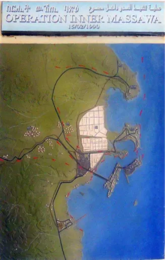
In the last section are the emblems of the war of independence: guns, uniforms, propaganda posters, the pictures of the war heroes and the women, who had a key-role in the final victory (Wilson, 1991). At the end of the last section, among the photos of the dramatic moments of independence, the key-figures of the battles and the slogans used for popular engagement, are exhibited two military maps. They are right at the end of the Museum and reproduce the movements of the troops during the crucial battles of the war of independence in the early 90s. At the starting point of the museum, as a first image for visitors on the right-hand wall, there is another military map, which shows the land and sea movements of the Eritrean troops in the
“Operation Inner Massawa” of 15 February 1990
(Figure 1). That was a fundamental step for the Eritrean troops for the taking of Massawa and for the incursion into the inner territories, which significantly contributed to the final achievement of national freedom.
That was a very important moment for Eritrean independence, after about thirty years of war against Ethiopia. The war was fought
mostly by the People’s Front for Eritrean
Liberation (PFEL), which in the “Fenkil
Operation” of February 1990 took the strategic
costal city. With it, they could also take control of the city-port, after which a reaction of the Ethiopian forces was baited, bombing the city and destroying part of it (Gessini, 2011, p. 29).
Indeed, just after that Operation, the FPLE forces marched towards Asmara, where the Ethiopian militias of the North Army of the Derg, with 200,000 units surrendered about one year following the taking of Massawa. The final victory in Asmara was possible also because
Mengistu escaped on 21st May 1991 (Gessini,
2011, p. 34). Three days later, on 24th May, the
Figure 1. Map of the “Operation Inner Massawa” hanging on a wall of the Regional Museum of Massawa.
At the end of the war, and with the establishment of an ad interim government, a political process started. It ended in 1993, with the legitimacy of the independence, officially
recognized after the referendum of 24th May
1993. On that occasion 99% of voters of the Eritrean people voted for national freedom from Ethiopia.
From a military point of view, the independence was in the end obtained after the battles of Massawa and with the taking of
Asmara, and the action of the Eritrean People’s
Liberation Front (EPLF) was of great
importance in this. The EPLF was massively involved in the 80s, as the most active front in Eritrea, “having conducted the most harsh and
bloody battles” (Gessini, 2011, pp. 31-32).
When the government was formed, one of the
most influent and active leaders of the Front, Isaias Afewerki, became the President of the new Eritrean State (Iyob, 1995, p. 140). After the popular liberation had been concluded, the
Eritrean People’s Liberation Front was renamed
in 1994 as the People’s Front for Democracy
and Justice (PFDJ).
In the provisional government, from 1991 to 1993, the relations between Eritrea and Ethiopia were basically good: even the port of Massawa, the centre of several battles in the years before, was declared free even to the traffic of goods to Ethiopia. Iyob underlines that “Ethiopia’s need for access to sea, which had been a major justification for its control over Eritrea, was met
without recourse to violence” (Iyob, 1995, p.
137).
3.
The map and the nationalistic spirit
In this “nationalistic frame”, of struggle fornational independence, linked to the sense of belonging to an autonomous culture, different from the Ethiopian one, with its own symbols of that national identity, even the military cartography can assume a key-role. An instrument able to point out a key moment of the independence and to focalize the collective memory on that crucial moment for military victory. The showing and celebration of the military map, indeed, has a deep significance, as a glorification of the war winning moment and then of the political autonomy obtained with the military struggle.
In the young national Eritrean entity, which is only about twenty years old, the corroboration of the national feeling is a crucial moment in the life of the nation. It is mostly used for giving the
young generations – which were not actually
part of the struggle for independence – the
elements to maintain a local identity. It is also useful as an element of counter position against the Ethiopian culture, which has represented, in the collective imaginary, the first enemy from whom it was necessary to set themselves free. Right now, Ethiopia is considered the first threat to Eritrean freedom and to the right definition of national borders: it could be considered one of the most relevant reasons why Eritrea is progressively becoming even more enclosed,
with a sort of fear of losing its hard fought freedom.
Eritrean identity, as for other national cases, is above all a question of the recognition of its own cultural, ethnic and even folkloric aspects, that have to be distinguished from others, with
their own characteristics – and even more so
when they are present or past enemies. National identity passes also through the maps that represent the most evident symbol of territorial conquests. The conquests of territories are strictly associated with the acquisition of military and then political power: that is what happened in the Eritrean case. As Monique
Pelletier pointed out: “maps tell even the
victories and the territorial progresses; and they may become documents for the propaganda,
whose diffusion is warmly encouraged”
(Pelletier, 2001, p. 93). It seems that Pelletier’s
assertion could be applied very well to the case
being dealt with, because from being
instruments of military strategy and “territorial
progresses”, maps assumed a status of “documents for the propaganda”, necessary for the “diffusion” of national identity.
4.
Geographical considerations
Eritrea’s geographical position has
gua-ranteed a natural access to the sea, mostly after the inauguration of the Suez Canal in 1869. Ethiopia could use it as a direct way to the Red Sea and to the related traffic from the Medi-terranean Sea to the East.
Why did the battles of Massawa have such a great importance in the history of Eritrea, being so strategic for the final victory, and why do they have such a primary role in the collective feeling even today?
It is possible to find the answers to these questions by just looking at the maps and studying the morphology of the country. First of all, Massawa was the first port of Eritrean territory, with direct access to the sea, and it was strategic both economically and commercially; secondly, because the taking of the city would have meant a significantly more rapid and easier way to reach Asmara. The capital city is 2,300
m. in altitude, “protected” by the upland, which
represents a natural barrier, and it is connected
with Asmara only by one road that is easily controlled. In short, the taking of Massawa would ensure a natural access to the Red Sea, and then the guarantee of starting the march towards Asmara.
Massawa, the second city of the country after Asmara, had a great, very beautiful and fascinating architectural development, in a mixture of Italian rationalism and Ottoman style (Montesanto, De Marchi and Traverso, 2009). In the past it was known for its beauty as “The
pearl of the Red Sea”. Today, Massawa shows
all of its consequences of the war. The traces of the battles are visible even today in the holes in the palaces, in the dust on the streets, in the deterioration of the buildings and in the ruins on the squares. The streets are desolated. The population lives in degraded conditions, with no services, with few street lights: this situation is mostly due to the lack of commercial and port activities, which caused a dramatic impact on
the city’s economy and life. Before the crisis
with Ethiopia between 1998 and 2000, the city was a hub of activity, as most of the local people are keen to remind us during our visit.
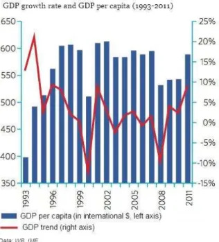
It is sufficient to have a look at the graphic
(significantly entitled “the wars stops the
economic growing”), elaborated by Treccani in
the “Atlante geopolitico 2013”, that shows the
trend of the GDP (in $) and the per capita GDP between 1993 and 2011, to outline the considerable decrease during the years of the second war between 1998 and 2000 (Figure 2).
In its apparent state of abandon, visible to the eyes of just a few tourists, Massawa seems to be a set of an apocalyptic movie. Nevertheless it exerts a timeless and undeniable fascination and a great touristic potential. The charm of the city can be felt in the silence and inactivity of the port, the signs of the past battles fought in the city. The maps of those battles, which hit the
beauty of “the pearl of the Red Sea” and which
contributed to the independence of the country, are now exhibited as symbols of the national Eritrean identity. This identity is today exalted in the Museum of the city, which has been
“soothed” since 1952, when Ethiopia annexed
Figure 2. GDP growth rate (%) and GDP per capita (international $), in Eritrea, 1993-2011.
Source: Treccani.it (“Atlante geopolitico 2013”).
The map, once an instrument for war developments and strategies, now has a further
function: the one we have defined as “symbolic”
and which might have a greater force compared to the merely functional one. As Emanuela Casti
wrote, “the conquest of a territory has the
consequence of the cartographic production that
attests the happened belonging of it” (Casti,
1998, p. 29) and the diffusion of that cartographic production among the population,
in fact, is “warmly encouraged”, as outlined by
Pelletier.
References
1. Bottaro L. (Ed.), Gli Italiani in Eritrea.
Esploratori, Missionari, Medici e Artisti, Asmara, 2003.
2. Brotton J., La storia del mondo in dodici
mappe, Milan, Feltrinelli, 2013.
3. Casti E., L’ordine del mondo e la sua
rappresentazione. Semiosi cartografica e autoreferenza, Milan, Unicopli, 1998.
4. Casti E., Cartografia critica. Dal Topos alla
Chora, Milan, Guerini, 2013.
5. Gessini M., La Guerra tra Etiopia ed Eritrea.
1998-2000, Rome, Gan, 2011.
6. Giordano A., Eritrea-Italia. Scenari politici,
economici e culturali: atti del seminario del 13 ottobre 2010, Rome, Società Geografica Italiana, 2011.
7. Heijden van der H.A.M., Leo Belgicus. An
Illustrated and Annotated Carto-bibliography, Utrecht, Canaletto Alphen aan den Rijn, 2006.
8. International Crisis Group, Eritrea: the Siege
State, Africa report n. 163, 21 September 2010.
9. Iyob R., The Eritrean Struggle for
Independence. Domination, resistance,
nationalism 1941-1993, Cambridge, Camb-ridge University Press, 1995.
10. Montesanto G., De Marchi G. and Traverso
G., Viaggio a Massawa. Storie, immagini e personaggi della perla del mar Rosso, Asmara, Liceo Marconi, 2009.
11. Nigusie A.A., Eritrea’s policy in the Horn of
Africa (1993-2008), Saarbrücken, VDM Verlag Dr. Müller, 2011.
12. Panetta E., L’Italia in Africa. Studi italiani
di etnologia e folklore dell’Africa orientale.
Eritrea Etiopia Somalia, voll. I-II, Rome, Istituto Poligrafico dello Stato, 1973-1974.
13. Pelletier M., “Carte e potere”, in VV.AA.
(Eds.), Segni e sogni della Terra. Il disegno del mondo dal mito di Atlante alla geografia delle reti, Novara, De Agostini, 2001.
14. Péninou J.L., “The Ethiopian-Eritrean
Border Conflict”, Boundary and Security
Bulletin, 1998, pp. 46-50, https://www.dur. ac.uk/resources/ibru/publications/full/bsb6-2_peninou.pdf.
15. Reid R., “Old problems in new conflicts.
Some observations on Eritrea and its relations with Tigray, from liberation struggle to inter-state war”, Africa, 73, 3, 2003, pp. 369-401.
16. Saleh M.A., The Saho of Eritrea. Ethnic
identity and national consciousness, Zurich and Berlin, Lit Verlag, 2013.
17. Wilson A., The challenge road. Women and
the Eritrean revolution, London, Earthscan, 1991.