Alma Mater Studiorum – Università di Bologna
DOTTORATO DI RICERCA IN
Storia Culture Civiltà
Ciclo XIX°
Settore Concorsuale di afferenza: 10/A1 Settore Scientifico disciplinare: L-ANT/10
TITOLO TESI
The Archaeology of Cahokia's West Plaza.
Excavations in the Merrell Tract.
Presentata da: Immacolata Valese
Coordinatore Dottorato
Relatore
Massimo Montanari
Davide Domenici
Abstract
With more than 100 earthen pyramids, Cahokia was the largest polity of pre-Columbian North America. Located a few kilometres from present day St. Louis (MO), it rose to be the greatest Mississippian settlement by the middle of the 11th century; until its abandonment at the end of the 14th century. Even though Cahokia is the largest Mississippian settlement, the archaeological investigations led at the site have interested only a small part of its extension. This dissertation focuses on the extensive excavations led in the Merrell Tract by the University of Bologna from 2011 to 2016. The investigations were carried out in one of the main public areas of the site, the West Plaza, and involved, for the first time at Cahokia, the employment of photogrammetry and GIS as methods of data management, recording and post processing. Along with the description of the results obtained during the University of Bologna’s excavations, the author dedicated part of the work to the collection of data from previous excavations led in the area since 1920s. Through the comparative analysis of the data recovered, the author intends to propose new hypothesis concerning the settlement dynamics and use of space of the area and its contextualization in the wider picture of the history of this Mississippian centre.
Acknowledgments
These last three years have been far from the easiest of my life. Writing this dissertation has been really challenging as I tried to conciliate research, work and personal issues. Luckily, I had so many people whose support and help was essential to succeed.
I would like to express my sincere gratitude to my tutor, Professor Davide Domenici. Since 2011, he has been a constant presence in my life, he guided and tutored me. He became my mentor; he taught me how to direct a field and how to be a good leader. But the most important thing he gave me was his trust; he trusted me to be a good fieldwork director, and gave me what has proven to be the most important opportunity of my life, so far. I know, I have been a pain in the back; thank you.
Professor John Kelly, I really thank you for the value you always gave to my thoughts. I consider you as one of the most inspirational persons I have ever met. Thank you for your trust and for sharing your precious knowledge, I will never forget our conversations on the field. Lucretia “Cricket” Kelly was not only a precious help in the analysis of the faunal assemblage recovered from the field, but above all she was the patient and supportive voice I needed to hear during many of the hard times I faced, Grazie.
Without the help of the Cahokia Mounds Museum staff, this research could not have been carried out. Mark Esarey, Bill Iseminger, Lori Belknap, Matt Migalla, you have been generous and perfect hosts. I still dream to see our excavation’s picture on your “wall of fame” after Wittry’s…just saying. Part of my research have been carried out at the Research and Collection Centre of Springfield, therefore I am thankful to Terrence Martin, Bonnie Styles and Dee Ann Watt for making yourselves available in order to fulfil my research-related needs. Among the organizations supporting my work I would like to mention and thank the Powell Archaeological Society and the Cahokia Mounds Museum Society.
During six years of this wonderful experience overseas I met amazing people, whit whom I shared unforgettable moments. I am extremely grateful to what I consider my “American Family”: the friends I have made on the field, Ken, Larry, Sedona and family, Dave, Alex, Filip, Emma, Angela, Ron, Frank, Greg to name a few. I know I’ve been “Dr. Evil”, pushing you to work no matter the weather; you all, volunteering on the excavations, made everything possible. The presence of each one of you left an indelible mark.
I cannot forget to thank my colleagues from University of Bologna who were involved in the Cahokia Project. Thank for the limitless patience towards me. A special thought is addressed to the two friends and tireless workers who have been into this since the beginning, Marco and Melissa. We shared so much, you have been my sidekicks. I am missing the constant arguing, the banana pancakes and “watching” Twin Peaks at the Bates Motel.
Once I began writing this dissertation, several moments of despair followed the hours passed staring empty pages. I survived all that thanks to the constant presence of Alessandra and Giulia. I am really thankful for the litres of good wine, the last-minute “support” dinners and for your friendship.
A great thank you is addressed to Tania, without you I could have not gone far in editing this dissertation. I owe you so many tortellini!
I am fully indebted to my mother and father for the material support they gave me, especially during these last three years. I thank you from the bottom of my heart for your encouragement, wisdom and patience towards me. I know I have not been a perfect daughter and most of the time I have been AWOL; I will try to make up for the time we lost. Grazie, vi voglio un bene infinito anche se non lo dimostro mai. I pay my deep sense of gratitude to Mariella, Zio Sabino, Nonno Francesco and all my extended family, you are all irreplaceable. I consider myself lucky to have you in my life.
Last, but not the least, I am thankful to the one who have been often awaken in the middle of the night trying to comfort me when I was down and I wanted to give up. To the one who always pushes me further than I think I can go. To the one who can stand me after ten years spent together. Thank you, Mario, it feels really good to have you by my side facing the trials of this life.
Table of Contents
List of figures ... VII List of tables ... XIII
Introduction ... 1
Chapter 1 Cahokia in a nutshell ... 5
1.1 Brief description of the Cahokia’s Plazas ... 9
Chapter 2 The West Plaza: layout and previous excavations... 13
2.1 The 15B Tract ... 19
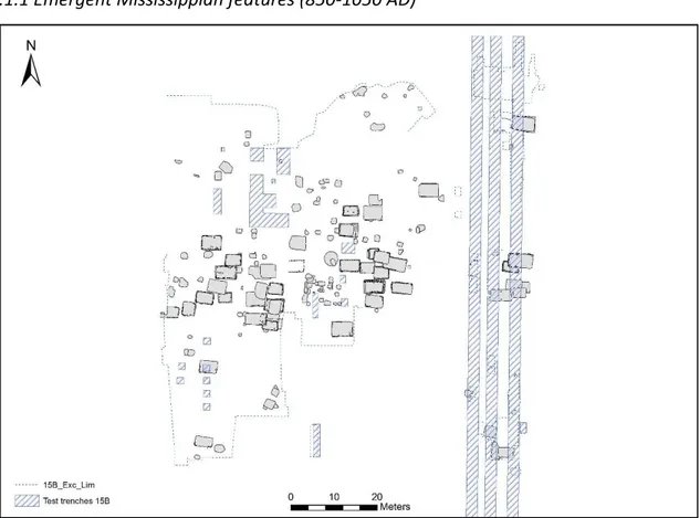
2.1.1 Emergent Mississippian features (850-1050 AD) ... 23
2.1.2 Early Mississippian Features (1050-1200 AD) ... 26
2.1.3 Late Mississippian features (1200-1350 AD) ... 36
2.2 The Merrell Tract Excavations ... 37
2.2.1 Emergent Mississippian occupation in the Merrell Tract ... 39
2.2.2 Early Mississippian occupation ... 40
2.2.3 Late Mississippian occupation ... 42
Chapter 3 The Cahokia Project ... 45
3.1 Methodology ... 46
3.2 Mapping strategy and data management ... 47
Chapter 4 The Merrell Tract-UNIBO excavations’data. ... 53
4.1 The Emergent Mississippian phase (850-1050 AD) ... 53
4.1.1 Structures ... 54
4.1.2 Non-structure features ... 71
4.1.3 Emergent Mississippian features located in Test Units ... 76
4.1.4 Pit features ... 81
4.2 The Early Mississippian occupation (1050-1200 AD) ... 96
4.2.1 Structures ... 97
4.2.2 Pit features ... 118
4.3 The Late Mississippian Phase (1200-1350 AD)... 120
4.3.1 Structures ... 122 4.3.2 Pit features ... 134 4.4 Unaffiliated features ... 162 4.5 Unexcavated features ... 171 4.6 Post holes... 173 4.7 Historic features – F1196, F1198, F1199 ... 176
5.1 Ceramic Material form the Merrell Tract-UNIBO’s excavations ... 179
5.2 Lithic materials from the Merrell Tract-UNIBO excavations ... 191
5.3 Faunal analysis for the Merrell Tract – UNIBO excavations .. Error! Bookmark not defined. 5.3.1 Emergent Mississippian faunal assemblage ... 202
5.3.2 Mississippian faunal assemblage ... 202
5.3.3 Discussion ... 206
5.4 Botanical analysis from the Merrell Tract – UNIBO ..... 215
5.4.1 Method ..... 215
5.4.2 Discussion ...... 215
Chapter 6 Interpretation ..... 241
6.1 The West Plaza area during the Emergent Mississippian occupation ..... 241
6.2 The Lohmann phase occupation ....... 249
6.3 The Stirling phase occupation of the West Plaza ..... 255
6.4 The West Plaza Area after the compounds ....... 269
6.4.1 The Late Stirling/Early Moorehead special buildings .......270
6.4.2 The Moorehead phase residential occupation ...... 274
6.5 The last occupation: the Sand Prairie phase ......281
Chapter 7 Summary and Conclusions ..... 287
References ..... 293
List of figures
Figure 1.1 Map of the American Bottom showing rivers, lakes and streams as well as the location of Cahokia and other Mississippian towns, villages and farmsteads. Adapted from map by Mikels
Skele. ... 5
Figure 1.2 The Emergent Mississippian Range Site (Kelly 1990 table 10.1). ... 6
Figure 1.3 LiDAR image of the Rattlesnake causeway (Baires 2014 fig. 2.5). ... 7
Figure 1.4 Map of the Greater Cahokia (Pauketat 2004 fig.4.1). ... 8
Figure 1.5 General map of Cahokia. The four plazas coloured in blue, black, yellow and red courtesy of J. Kelly. ... 10
Figure 1.6 View from the North Plaza. Michael Hampshire, Cahokia Mounds State Historic Site. 11 Figure 2.1 Historic pictures of Sawmill Mound’s excavation and burial n°11 (Kelly 2000). ... 14
Figure 2.2 Detail of the West Plaza from general map made by Moorehead in 1923 (adapted from Fowler 1997). ... 14
Figure 2.3 Mound 42 in the 1920 (Fowler 1997). ... 16
Figure 2.4 Map of the 1950’s excavation in the West Plaza area (courtesy of J. Kelly). ... 17
Figure 2.5 SIUE map with location of the test units (from Ringberg 1996). ... 18
Figure 2.6 15B Tract, Cahokia. General Shot, Research and Collection Centre (Springfield, IL). ... 19
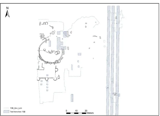
Figure 2.7 General GIS map of 15B Tract (I. Valese)... 21
Figure 2.8 Detail GIS map of the 15B Tract’s Emergent Mississippian features (I. Valese). ... 23
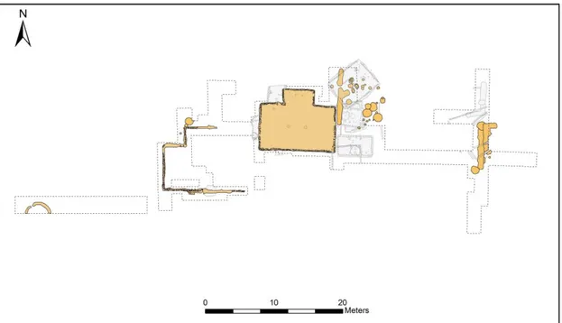
Figure 2.9 Detail GIS map of the 15B Tract’s Early Mississippian features (I. Valese). ... 26
Figure 2.10 Map of the rotunda F388 (I. Valese). ... 27
Figure 2.11 F388 during 1960s’ excavation. Slide 10-9 and 8-32 kept at RCC. ... 27
Figure 2.12 Map of the rotunda F238/389 (I. Valese). ... 28
Figure 2.13 F238-389, detail. Slides from Research and Collection Centre (Springfield, IL). ... 29
Figure 2.14 GIS map detail of bastioned compounds. Compound A in blue and compound B/C in orange (I. Valese). ... 30
Figure 2.15 Detail of H114 and H123 (I. Valese). ... 31
Figure 2.16 H114, photo kept at RCC. ... 32
Figure 2.17 F358 map detail (I. Valese). ... 33
Figure 2.18 Detail map of H10 and H20 (I. Valese). ... 34
Figure 2.19 Detail map of H6 and H21 (I. Valese). ... 35
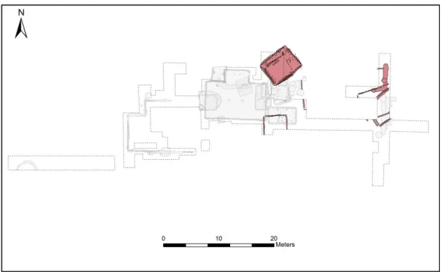
Figure 2.20 Detail map of Late Mississippian features of 15B Tract (I. Valese). ... 36
Figure 2.21 GIS general map of Merrell Tract – Beloit College excavations (I. Valese). ... 38
Figure 2.22 Emergent Mississippian features in the Merrell Tract’s excavations (I. Valese). ... 39
Figure 2.23 In orange, the Early Mississippian features from Merrell Tract – Beloit College (I. Valese) ... 40
Figure 2.24 Late Mississippian features of the Merrell Tract highlighted in green (I. Valese). ... 42
Figure 2.25 Map of the West Plaza Area indicating the location of the investigations led since 1920 (I. Valese). ... 44
Figure 3.1 Detail of West Plaza Area with the location of Merrell Tracts and 15B Tract (I. Valese). ... 46
Figure 3.2 Location of Fowler’s control points (N200 W300 and N200 W500) and UNIBO’s (N200 W250) (I. Valese). ... 48
Figure 3.3 From the photometric image to the GIS map (I. Valese). ... 49
Figure 4.2 Detail of burned log found in the basin's fill of F1013 and two postholes of the house.
... 55
Figure 4.3 Numbered postholes of F1013 and table with depths of F1013 postholes, measured by probing. ... 56
Figure 4.4 Photometric image of F1013/H107 and superimposed features. ... 56
Figure 4.5 Map detail of F1044 and its superimposing features (I. Valese). ... 57
Figure 4.6 Photometric image of F1044... 58
Figure 4.7 F1044 in plan, sterile silty soil in profile. ... 58
Figure 4.8 Photometric image of F1046... 59
Figure 4.9 F1073 in 2013. ... 60
Figure 4.10 Map detail of F1073 in 2015 and location of F1086/F1191 (test pit location in blue). ... 61
Figure 4.11 F1086/1191’s postholes photometric image in GIS. ... 62
Figure 4.12 F1086/1191 East Profile. ... 63
Figure 4.13 Detail of the basin's fill of F1189 in Test Unit N188 W243. ... 64
Figure 4.14 F1167 detail of a photometric image from 2014's excavation. ... 65
Figure 4.15 F1167 map (I. Valese). ... 65
Figure 4.16 South profile of the Test Unit dug into F1167 (I. Valese). ... 66
Figure 4.17 West profile of the Test Unit dug into F1167 (I. Valese)... 66
Figure 4.18 Photometric images of the test units in which F1189 was located. ... 67
Figure 4.19 F1189's map (I. Valese). ... 68
Figure 4.20 North profile of Test Unit in N188 W243 (I. Valese). ... 68
Figure 4.21 Map detail of F1211 and F1213 (I. Valese). ... 69
Figure 4.22 Detail of southeastern limit of F1211 and superimposed F1193's northern and western walls. ... 70
Figure 4.23 F1160 South and West profile at N188 W240. ... 72
Figure 4.24 Probes realized in F1160. ... 73
Figure 4.25 Photometric image of the southern profile of TU-N190 W241-242. ... 74
Figure 4.26 View of F1031. ... 75
Figure 4.27 General map of the excavation area, Test Units indicated in blue (I. Valese). ... 76
Figure 4.28 TU-N180W239, detail of southern wall of F1193 and F1227. ... 77
Figure 4.29 Detail of F1226's postholes at N186 W237. ... 78
Figure 4.30 Detail of F1234 in unit N186 W239. ... 78
Figure 4.31 Figure 63 Image of F1233 located in TU-187 W241. ... 79
Figure 4.32 Image of the Emergent Mississippian postholes (F1232) recovered in TU-189 W239/240. ... 79
Figure 4.33 Detail of TU-N179/180 W235, in the image are shown the postholes of F1231 and the wall trench of F1193. ... 80
Figure 4.34 F1016 during the excavation... 81
Figure 4.35 F1016 North profile (F. Debandi). ... 82
Figure 4.36 Detail of the pottery concentration in F1017E's Zone B. ... 83
Figure 4.37 Image of F1017E and F1017W after the removal of the southern halves. ... 84
Figure 4.38 F1017E and F1017W's northern profiles. ... 85
Figure 4.39 Image of F1013 during excavation and associated F1022. ... 86
Figure 4.40 F1027 West Profile. ... 87
Figure 4.41 Image of F1027's western profile. ... 87
Figure 4.42 F1028/1070. ... 88
Figure 4.44 North profile of F1064 and F1040 (F. Debandi)... 90
Figure 4.45 North profile of Southern half of F1059 and F1061 (I. Valese). ... 91
Figure 4.46 Detail of F1080. ... 92
Figure 4.47 F1080 North profile (C. Deiana)... 93
Figure 4.48 F1080 East profile (I. Valese). ... 93
Figure 4.49 F1171/1197 North profile... 95
Figure 4.50 Early Mississippian features located in UNIBO excavations (I. Valese). ... 96
Figure 4.51 F1030, western side recovered in the Merrell Tract excavation (I. Valese). ... 97
Figure 4.52 One of the southern bastions of the compound excavated in the 15B Tract. Original picture kept at RCC, Springfield. ... 98
Figure 4.53 F1030's postholes, detail of the orange material. ... 99
Figure 4.54 Southern profile of a posthole belonging to the southwestern corner bastion of F1030 (I. Valese). ... 100
Figure 4.55 Postholes resulting from the excavation of the wall-trenched bastion. ... 101
Figure 4.56 Profiles of F1030's western wall postholes. ... 102
Figure 4.57 Cross-section and image of the portion of the wall trench of F1030. ... 103
Figure 4.58 Western profile of F1030's western wall shallow postholes. ... 103
Figure 4.59 Photometric images processed in ArcGIS showing the wall-trench and the postholes of the two reconstructed bastions of F1030. Before and after the realization of the shapefile. 104 Figure 4.60 East and West profile of F1030B. ... 105
Figure 4.61 Details of F1030b’s wall trench – East and West profile. ... 106
Figure 4.62 Map of F1033-Complex (I. Valese). ... 108
Figure 4.63 Detail of orange clay filled posthole of F1037W. ... 109
Figure 4.64 F1037W North and South profiles (C. Deiana). ... 110
Figure 4.65 West profile of F1037N and F1063 (I. Valese). ... 110
Figure 4.66 F1033W and F1038 North profile (C. Deiana). ... 111
Figure 4.67 F1063, F1033 and F1037 West profiles (C. Deiana). ... 111
Figure 4.68 Total map of F1067-1069 Complex or H129 (I. Valese). ... 113
Figure 4.69 F1069 East profile with detail of superimposition on F1080 (C. Deiana). ... 114
Figure 4.70 F1067 East profile, detail of superimposition between F1067 and F1079 (I. Valese). ... 114
Figure 4.71 General map of F1010 (H114) (I. Valese). ... 115
Figure 4.72 Profile of F1010 wall trench superimposing on F1013. ... 116
Figure 4.73 Image of F1057’s postholes. ... 116
Figure 4.74 Unit C (north half), map of the top level 9 (M. Valeri). ... 117
Figure 4.75 F1165’s eastern half. ... 118
Figure 4.76 F1165's eastern profile (I. Valese). ... 119
Figure 4.77 General map of Moorehead’s features from UNIBO excavations (I. Valese). ... 120
Figure 4.78 General map of Sand Prairie’s features from UNIBO excavations (I. Valese). ... 121
Figure 4.79 Drawing and picture of F1001's Northern profile. ... 123
Figure 4.80 Detail of F1001 in the northern part of the excavation area. ... 123
Figure 4.81 Map detail of F1001/358 (I. Valese). ... 124
Figure 4.82 Profile of F1005’s postholes (F. Debandi). ... 126
Figure 4.83 East profile of F1005 Northern wall (I. Valese). ... 126
Figure 4.84 Detail of F1005 with possible associated features (I. Valese). ... 127
Figure 4.85 F1009/1100 (H123) general map (I. Valese). ... 128
Figure 4.86 Detail of sterile clay soil beneath F1100’s northern wall. ... 129
Figure 4.88 Profile of F1100/F1009's northern wall trench (I. Valese). ... 130
Figure 4.89 F1193 west profile (I. Valese). ... 132
Figure 4.90 Detail map of F1193/1025 with possibly associated features and clay layer F1201 (I. Valese). ... 133
Figure 4.91 Detail of F1011 and rim sherds. ... 134
Figure 4.92 Picture of F1015 midden, detail of Ramey Incised bodysherds concentration. ... 135
Figure 4.93 Map of the material concentrations in F1015 (M. Valeri). ... 136
Figure 4.94 . F1019 zones A and B. ... 137
Figure 4.95 Photo of the top of F1019 Zone B. ... 137
Figure 4.96 Photo of top of F1019 Zone C. ... 138
Figure 4.97 . Photo of F1019C bottom. ... 138
Figure 4.98 Photo of the F1020B profile and the bottom of F1020A. ... 139
Figure 4.99 Photo of the F1020B profile. ... 139
Figure 4.100 Photo of pottery sherds in F1020B. ... 139
Figure 4.101 Photo of the F1020 Zone C. ... 140
Figure 4.102 Photo of Hooded Water Bottle in F1020C. ... 140
Figure 4.103 Midden area before the removal of F1020a and F1015 (M. Valeri and I. Valese). 141 Figure 4.104 Midden area after removal of F1020a and F1015 (M. Valeri and I. Valese). ... 142
Figure 4.105 North Section of N212-W235/7 (M. Valeri). ... 143
Figure 4.106 North Section of N211-W235/7 (M. Valeri). ... 143
Figure 4.107 Features before and after excavation. ... 144
Figure 4.108 Profile of features located at n203-204 and w238-239 (C. Deiana). ... 145
Figure 4.109 Detail of Ramey Incised rim sherd found in the midden area. ... 147
Figure 4.110 Detail of charred corncobs. ... 148
Figure 4.111 F1046, F1049 and F1165 photometric image. ... 148
Figure 4.112 F1049 eastern profile (I. Valese and M. Mattioli). ... 149
Figure 4.113 F1049 northern profile (I. Valese and S. Armenio). ... 149
Figure 4.114 Features recovered in the northern units of the excavation at level 9 (M. Valeri). 151 Figure 4.115 Features recovered in the northern units of the excavation at level 7 (M. Valeri). 152 Figure 4.116 Features recovered in the northern units of the excavation at level 8 (M. Valeri). 152 Figure 4.117 Map detail of F1064 (I. Valese). ... 153
Figure 4.118 F1064 and F1040's southern profile (I. Valese). ... 153
Figure 4.119 Detail map of F1081 (I. Valese). ... 154
Figure 4.120 F1081 at different levels (I. Valese). ... 155
Figure 4.121 Picture of some of the object found in F1081. ... 156
Figure 4.122 Eastern profile of F1081 (C. Deiana). ... 157
Figure 4.123 Map detail of F1112 (I. Valese). ... 158
Figure 4.124 Multilevel photometric image of F1112. ... 158
Figure 4.125 F1112's southern profile with details (C. Deiana and M. Mattioli). ... 159
Figure 4.126 F1112's southern profile (C. Deiana and M. Mattioli). ... 159
Figure 4.127 F1130 south profile (C. Deiana). ... 160
Figure 4.128 Detail map of F1003 (I. Valese). ... 162
Figure 4.129 Image of F1003 after the removal of the western half. ... 163
Figure 4.130 Zenithal photomap of Area B with F1012 delineated in black. ... 164
Figure 4.131 Detail of clayish component of F1012. ... 164
Figure 4.132 Northern and western profile of F1024. ... 164
Figure 4.133 Western profile of F1026 (I. Valese). ... 165
Figure 4.135 Detail map of F1071. ... 166
Figure 4.136 Map of the area in which F1082 was located (I. Valese). ... 167
Figure 4.137 North profile of F1088 and F1089 (C. Deiana). ... 168
Figure 4.138 Southern profile of F1091/1092. ... 169
Figure 4.139 Detail of F1196. ... 176
Figure 4.140 The anomaly F1196 in the magnetic survey (courtesy of J. Burks). ... 177
Figure 5.1 Monks Mound Red vessel reconstructed from fragments retrieved in F1017E. ... 181
Figure 5.2 Ramey Incised Jar rims found in Merrell Tract-UNIBO. ... 183
Figure 5.3 Vessel assemblage from Merrell Tract-UNIBO’s features (I. Valese and M. Mattioli).185 Figure 5.4 Chart showing the number of rims not associated to a vessel type located in unaffiliated features (I. Valese and M. Mattioli). ... 185
Figure 5.5 Chart showing the number of beakers’ rims located in the University of Bologna's excavations. The highest frequency of shell-tempered beakers is attested for the Moorehead phase (I. Valese and M. Mattioli). ... 185
Figure 5.6 Column chart showing the type of beakers found in the Merrell Tract’s features (I. Valese and M. Mattioli). ... 186
Figure 5.7 Chart showing the amount of bowls’ rims from features considering tempers and chronological affiliation (I. Valese and M. Mattioli). ... 186
Figure 5.8 Frequency of bowls’ rims divided by type and phase (I. Valese and M. Mattioli). ... 186
Figure 5.9 Shell-tempered bottles’ rims from Merrell Tract (I. Valese and M. Mattioli). ... 187
Figure 5.10 Chart showing the tempers of plates recovered in the Merrell Tract in the different phases of occupation. The majority is represented by shell tempered samples dated to the Moorehead phase (I. Valese and M. Mattioli). ... 187
Figure 5.11 Frequency of different type of plates’ rim located in the Merrell Tract divided by chronological association (I. Valese and M. Mattioli). ... 187
Figure 5.12 Shell-tempered platters divided by phase. The majority of this vessel type was recovered in Moorehead features (I. Valese and M. Mattioli). ... 187
Figure 5.13 Chart showing the frequency in different phases of different types of platters located in the Merrell Tract (I. Valese and M. Mattioli). ... 188
Figure 5.14 Tempers of funnels, divided by phase, recovered in University of Bologna's excavations (I. Valese and M. Mattioli). ... 188
Figure 5.15 Frequency of coarse ware funnels in the different phases of occupation of the area (I. Valese and M. Mattioli). ... 188
Figure 5.16 Chart showing the tempers of seed jars' rims from Merrell Tract's features. The rims have been divided by chronological affiliation (I. Valese and M. Mattioli). ... 188
Figure 5.17 Chart showing the different types of seed jars’ rims, located in the excavation, and divided by chronology (I. Valese and M. Mattioli). ... 189
Figure 5.18 Tempers of the pans’ rims recovered from the field divided by chronological association (I. Valese and M. Mattioli). ... 189
Figure 5.19 Chart showing the pans’ type recognized among the Merrell Tract’s ceramic assemblage (I. Valese and M. Mattioli). ... 189
Figure 5.20 Frequency of Jars’ rims from Merrell Tract, divided by phase (I. Valese and M. Mattioli). ... 190
Figure 5.21 Jars’ types recognized in the assemblage, divided by phase (I. Valese and M. Mattioli). ... 190
Figure 5.22 Picture of some F1081’s bones. ... 204
Figure 5.24 Drilled bone ornament (catalogue #73-2191-242) found during the excavations at the
East Palisade, exposed at the Cahokia Mounds Museum. ... 206
Figure 6.1 Map of the Emergent Mississippian occupation of the area. Houses in tan, pit features in green, F1160 in blue (I. Valese). ... 241
Figure 6.2 Detail map of the Emergent Mississippian Courtyards located in the West Plaza Area. Actual courtyards in green, hypothetical in red. ... 245
Figure 6.3 Original profile of "Blue Fill" from 1960's fieldnotes. (Courtesy of Research and Collection Centre, Springfield). ... 246
Figure 6.4 Map of the Lohmann phase occupation of the area. Highlighted the Lohmann phase's features (I. Valese). ... 249
Figure 6.5 Circular structure on Mound 8 at Kinkaid (adapted from Welch et al. 2007). ... 252
Figure 6.6 One of the circular anomaly found at Etowah (adapted from King 2013). ... 252
Figure 6.7 Mound D earth lodge at Ocmulgee (Plate 37, A. Kelly 2010). ... 253
Figure 6.8 Drawing of a Cherokee winter townhouse at Chota, by Thomas Whyte. Frank H. McClung Museum Photographic Collection, University of Tennessee, Knoxville. ... 254
Figure 6.9 Map of the Stirling phase occupation of the West Plaza (I. Valese). ... 256
Figure 6.10 Original sketches of West Plaza’s compounds realized by W. Wittry (Courtesy of the Research and Collection Center, Springfield). ... 259
Figure 6.11 Compound B/C and sequence of possible associated buildings (I. Valese). ... 260
Figure 6.12 Compound B/C with reconstruction of the northern wall (I. Valese). ... 263
Figure 6.13 Mound 55, pre-mound buildings (Smith 1969, fig.33)... 264
Figure 6.14 3D reconstruction of Compounds A and B/C. Realized with Google SketchUp. ... 265
Figure 6.15 Possible paths of Cahokia palisade. Adapted from Bruni (2013: 135 fig.22). ... 267
Figure 6.16 Detail map of Early Moorehead phase buildings and post pits located in the area (I. Valese). ... 270
Figure 6.17 Detail of residential buildings located in the area during the Late Moorehead phase (I. Valese). ... 275
Figure 6.18 Detail of burials located in the West Plaza Area (I. Valese). ... 280
Figure 6.19 Detail map of Sand Prairie phase structures located in the West Plaza Area. In this map are represented exclusively the structures that can be attributed with certainty to the Sand Prairie phase. ... 281
Figure 6.20 Detail of H112 burned daub (slide 9-11 RCC) ... 284
Figure 6.21 Ceramics and burned logs, H43-56 (slide 5-21 RCC) ... 284
Figure 6.22 Map of hypothetical Sand Prairie phase house clusters (HC) sharing the same orientation. Courtyards in blue. Elaborated unifying the Sand Prairie phase maps from Kelly (1995) and Pauketat (2013) in which the houses attributable to this specific phase are different (I. Valese). ... 285
List of tables
Table 1-1 Chronological phases, adapted from Iseminger 2010. ... 12
Table 4-1 Table showing F1013’s postholes depths. ... 56
Table 4-2 List of Unaffiliated features excavated. ... 170
Table 5-1 Percentage of tempers in the total amount of pottery sherds recovered from the excavated area (M. Mattioli). ... 179
Table 5-2 Total amount of lithic material recovered in the Merrell Tract-UNIBO (I. Valese and S. Armenio). ... 191
Table 5-3 Summary of the chert and lithic other than chert tools recovered in the Merrell Tract (I. Valese and S. Armenio). ... 198
Table 5-4 Summary of minerals found in the Merrell Tract-UNIBO (I. Valese and S. Armenio). . 199
Table 5-5 Summary of fluorite and quartz fragments located in the Merrell Tract-UNIBO (I. Valese and S. Armenio). ... 200
Table 5-6 Key to the animal size categories constructed (L. Kelly). ... 201
Table 5-7 Taphonomic Summary of Merrell Tract Fauna (excludes F. 1081) (L. Kelly). ... 207
Table 5-8 Summary of Faunal Remains from Emergent Mississippian Features on the Merrell Tract (L. Kelly). ... 208
Table 5-9 Summary of Faunal Remains Recovered from Late Stirling/Early Moorehead Features on the Merrell Tract (L. Kelly). ... 209
Table 5-10 Summary of Faunal Remains Recovered from Moorehead and Sand Prairie Features on the Merrell Tract (L. Kelly). ... 210
Table 5-11 Taphonomic Summary of Fauna Recovered from Feature1081 (L. Kelly). ... 211
Table 5-12 Summary of Fauna recovered from Feature 1081 (L. Kelly). ... 2132
Table 5-13 Bird Elements from F1081 (L. Kelly). ... 2143
Table 5-14 Summary of Faunal Remains from Unaffiliated or Non-specific components on the Merrell Tract (L. Kelly). ... 214
Table 5-15 Summary of the data analysed from 2012 to 2015 excavation (K. E. Parker). ... 217
Table 5-16 Emergent Mississippian features F1013, 1016, 1017 and F1022 botanical remains (K. E. Parker). ... 219
Table 5-17 Emergent Mississippian features F1040 and F1080 botanical remains (K. E. Parker). ... 221
Table 5-18 Emergent Mississippian F1027 botanical remains (K. E. Parker). ... 222
Table 5-19 Faunal remains from Late Stirling Features F1030 (Compound B/C) and F1165 (K. E. Parker). ... 223
Table 5-20 Faunal remains retrieved in Late Mississippian features: F1001, 1005, 1009, 1019, 1019B and 1020 (K. E. Parker). ... 226
Table 5-21 Moorehead phase midden area F1049's faunal remains (K. E. Parker). ... 228
Table 5-22 Partial results of the faunal analysis of the Moorehead pit F1081. ... 231
Table 5-23 Partial results of the analysis of the botanical remains retrieved in F1081 (K. E. Parker). ... 233
Table 5-24 Faunal remains retrieved from F1033, 1034, 1037, 1059, 1062, 1112, 1132 and 1146 (K. E. Parker). ... 236
Table 5-25 Faunal remains from F1169 and 1170. ... 238
Introduction
Located in southern Illinois, a few kilometres from present day St. Louis (MO), Cahokia was the largest polity of pre-Columbian North America. It became the most prosperous Mississippian settlement by the middle of the 11th century reaching the acme of its greatness throughout the 12th century, to be then slowly depopulated by the end of the 14th. With its 120 earthen pyramids arranged in clusters around plazas, it reached an estimated population ranging from 10,000 to 15,000 individuals (Milner 2006; Pauketat and Lopinot 1997) spread on 16 km2, growing to a size comparable to the 11th century city of London (Fowler 1997; Kelly 2000; Chappell 2002; Dalan et al. 2003; Iseminger 2010; Pauketat and Alt 2015). The size and monumentality of the settlement made this site an exemplary case in North America; multiple hints suggest that at Cahokia the egalitarian societies that had prospered for millennia in the Eastern Woodlands developed in the first ranked political system (Mehrer 1995; Roger and Smith 1995; Brown and Kelly 2015). Because of its complexity, Cahokia has been at the centre of a longstanding debate concerning the degree of its economic and political system and about its relationship with its hinterland (e.g. Blitz 1999; Cobb 1993; Rogers and Smith 1995; Emerson 1997; Welch 2006; Brown and Kelly 2015). At first, it was categorized as a chiefdom (Milner 2006) or a “Complex Chiefdom” (Pauketat and Emerson 1997: 3) a definition that implied the recognition of its complexity but still including it in a chiefdom rank due to the “lack of formal bureaucrats” (Pauketat and Emerson 1997). Other scholars attributed to Cahokia the role of capital of a state the extension of which would have encompassed the American Bottom region as a whole (O’Brien 1989; Zimmermann Holt 2009). Today, even though the attribution of neo-evolutionary labels is considered less relevant in the theoretical debate (Pauketat 2007), the common opinion is that Cahokia was a city that flourished detached from the state-making process. This interpretation is based on four main archaeological indicators: scale, site plan, monumentality, and socially differentiated hinterland (Kelly and Brown 2014; Brown and Kelly 2015; Pauketat, Alt and Kruchten 2015). Nonetheless, whatever Cahokia should be labelled, the focus is on the understanding of its complexities and the characteristics that made Cahokia an example of urban development among the Pre-Columbian societies in North America. This dissertation follows a different approach, less focused on this debate, but rather using
raw archaeological data as a starting point in order to provide new insights on the broader issues related to the site's development. Before extensive excavations at the site, scholars considered Cahokia as a big ritual centre with no residential areas (Young and Fowler 2000); this common view changed after the 1960s extended investigations carried out in 15A and 15B Tracts (Pauketat 1998; Valese 2012; Pauketat 2013). The archaeological record, in fact, unveiled the presence of a dense and continued occupation of the site from the Emergent Mississippian phase to the Sand Prairie phase, hence before the rise and until the demise of Cahokia (Wittry and Vogel 1962; Fowler 1997). Moreover, after the implementation of a huge salvage excavation project in 1977, that encompassed the entire American Bottom area, several Mississippian settlements were brought to light revealing a more complex picture of the Mississippian world than previously thought (Young and Fowler 2000). Those fieldworks sanctioned the importance of extensive investigation and the importance to focus on realities other than mound as well. Until 1970s, in fact, the main focus of the archaeological investigation at Cahokia were the earthen pyramids (Fowler 1997; Kelly 2000), excavations from which were recovered enormous quantities of artifacts, as for the case of the Beaded Burial at Mound 72 (Fowler et al. 1999), or the location of élite mound-summit structures, as the rectangular building excavated on top of Monks Mound (Reed 2009). Areas, such as the plazas, previously considered arid of information, on the contrary, revealed themselves to be rich in data that could help comprehend Cahokia’s reality. So far, it has been estimated that the excavated surface of the site is less than one percent of its total extension (Dalan et al. 2003: 48). Although, other methods of non-invasive investigations (i.e. geophysical and magnetic survey, and surface collection) have been successfully applied, targeted extensive excavations are still, according to the author, the most efficient method of data collection and interpretation. The latest archaeological investigations of this kind have been carried out from 2011 to 2016 by the University of Bologna in the Merrell Tract, located in the central core of the site approximately 300 meters west of Monks Mound, the main Cahokia’s earthwork. The researches in the area aimed at clarifying the settlement dynamics and the use of space and more specifically at understanding the transition from a residential area to a large open arena with public buildings during Cahokia’s apogee. The location of the excavation was chosen for the proximity to the abovementioned 15B Tract, of which it can be considered a continuation. The
archaeological explorations undertaken by the Italian team have revealed hundreds of features spanning through the entire Cahokia’s chronology from the Emergent Mississippian to the Sand Prairie occupation, in line with the results of the former investigations of the area. The main focus of this dissertation is to disclose in detail the results of the University of Bologna’s investigations as well as for the method employed both during the work on the field and in the post-processing of the data. The choice of specific methods has had an essential role during these three years of researches. As coordinator of the archaeological operations, the author, decided to rely on informatic methodologies to manage and interpret the archaeological record at its best. The mapping of the stratigraphy was realized by means of photogrammetry, for the first time applied at Cahokia, elaborated and vectorized in a GIS environment. A Geodatabase was realized by the author to host the data recovered from the ongoing excavations as well as the archaeological record derived from the former excavations realized in the surrounding area. Henceforth, one of the main efforts at the base of this dissertation has been the systematic collection of the information concerning all previous investigations led in the West Plaza Area since 1920s. As for West Plaza Area, the author refers to the area located West of Monks Mound and surrounded by Mound 39, 77, 40, 41, 48, 47, 73, 42 and 76. This definition will be generally used also for the periods when this area was not a public space. All the collected data have been digitized and merged into the abovementioned GIS in order to obtain a complete set of data of the investigated area. Once integrated, the data from the different excavations have been compared to one another. The interpretation of the University of Bologna’s archaeological record along with the exhaustive analysis of the data from former excavations have provided the key to reinterpret and formulate new hypothesis concerning the dynamics of occupation that interested the West Plaza area and the function of the unearthed structures. A further effort has been dedicated towards the contextualization of the data recovered from the University of Bologna’s excavations in the wider picture of Cahokia’s history, in order to provide a more complete understanding of the settlement dynamics that interested the area and, in a broader view, their implications on Cahokia’s emergence and demise. The results obtained through these three years of researches suggest, in fact, a more complex picture in which landscape modifications, possibly related to the “creation” of Cahokia as known at its acme, were taking place already by the end of the Emergent Mississippian
phase. The chronological sequence of the public buildings, which stood in the area while it functioned as a Plaza, have been proposed on the basis of new findings that led to the reinterpretation of some of the previous investigation’s data. The University of Bologna’s investigations, additionally, yielded an important amount of new information concerning the last occupational phases of the area supporting the hypothesis that the performance of communal and domestic ritual even after the area was not anymore a public space. The dissertation will be organized as follows: the first chapter will be dedicated to an overview about the state of art of Cahokia’s investigations, with a more detailed paragraph about the other main plazas of the site. In the second chapter an accurate description of the previous investigations led in the West Plaza area will be provided, starting from Warren King Moorehead’s excavations of the 1920s’ to the last testing of the Southern Illinois University-Edwardsville made at the slope of mound 48 in 1995. The results of the excavations of the 1960s’ 15B and the 1970s’ Merrell (Beloit College) Tracts will be described thoroughly, by chronological phase, as they constitute the major source of data concerning the West Plaza a
rea occupational sequence. The third chapter will be devoted to the University of Bologna’s project; a detailed description of the methodological aspect concerning field operations, topography and data management will be given. In chapters three and four, the features located during the University of Bologna’s (UNIBO) excavations will be described in detail. All the features will be presented as divided by chronological phases: Emergent Mississippian, Early Mississippian, Late Mississippian, Unaffiliated and Historic. The features will be arranged, for each period, as structures, non-structures and pit features. Tables of unexcavated features and post holes will be attached at the end of chapter seven. Detailed maps, excavation photographs and metric information will be provided. A synthesis of the material assemblage recovered from the excavations will be proposed in chapter 5. Since the analysis of the ceramic and lithic materials have been carried out respectively by M. Mattioli, F. Amato and S. Armenio, it has been possible to provide here a general description of the results. The excavation reports contain more detailed information, pictures and drawing of the single items. The same approach has been adopted for the description of the faunal and botanical remains, the analyses of which have been carried out respectively by L. Kelly and K. Parker. The final chapter will be focused on the interpretation of the data presented in the previous chapters.
Chapter 1 Cahokia in a nutshell
Cahokia was the main settlement of a Mississippian polity that flourished in the so-called American Bottom, an alluvial plain formed at confluence of the Mississippi and Missouri rivers (Dalan et al. 2003; Emerson 1997; Fowler 1997; Young and Fowler 2000; Iseminger 2010; Kelly and Brown 2014; Milner 2006; Pauketat and Emerson 1997; Pauketat 2004, 2009; Pauketat and Alt 2015).
Figure 1.1 Map of the American Bottom showing rivers, lakes and streams as well as the location of Cahokia and other Mississippian towns, villages and farmsteads. Adapted from map by Mikels Skele.
The area was rich in fertile alluvial soils and wet areas hosting abundant animal and vegetal life, providing perfect conditions for human occupation that started since the tenth millennium BC with small groups of Paleoindian hunters and gatherers followed, from 8000 BC, by Archaic hunters and gatherers. The fertility of the soil allowed, from the
mid of the first millennium BC to ca. AD 800, the settlement of horticultural communities of the Woodland Tradition that based their sustenance on the Eastern Agricultural Complex (chenopod (Chenopodium berlandieri), maygrass (Phalaris carolinana), erect knotweed (Polygonum erectum) and little barley (Hordeum pusillum) combined to hunting and gathering activities (Fritz and Lopinot 2007). At the end of the ninth century, new forms of community organization and a rapid increase in sociopolitical complexity led to the growth of a series of Emergent Mississippian villages (AD 850-1050) nucleated especially on the south bank of the Cahokia Creek, on the Edelhardt meander scar known as “Helms Ridge” (Dalan et al. 2003). The rise of those villages was tied to technological innovations such as bow and arrow and the introduction of maize along with the EAC cultigens. They were composed by clusters of rectangular, single-post “pit houses” usually arranged around small plazuelas, whose centers were marked by central wooden posts, by groups of four pits located at the four cardinal directions and/or by large, communal single-post buildings (Kelly 1982, 1990a, 1990b).
Figure 1.2 The Emergent Mississippian Range Site (Kelly 1990 table 10.1).
Around the mid of 11th century, at the beginning of the Lohmann phase, a radical transformation of the landscape took place in a unique event labeled by Pauketat “Big Bang” (1994). The Emergent Mississippian communities were relocated in order to create a brand-new settlement, whose monumental epicenter was centered on Monks Mound, a huge earthen mound around which four plazas were placed at the cardinal direction following the Native American cosmological pattern of quadralateralism (Kelly 1996a; Kelly and Brown 2014). Along the erection of the massive Monks Mound, an earthwork
with a volume of 622,000 m3, the construction of the southern Grand Plaza required an enormous effort to artificially level the natural landscape of ridges and swales over an area of 16 ha (Alt, Kruchten and Pauketat 2010). The monumentalization of the settlement continued through the later Stirling (AD 1100-1200), and Moorehead (AD 1200-1275) phases with the erection of more than hundred earthen mounds used as boundaries of the plazas and the settlement itself and as support for élite residences, charnel houses, mortuaries or sacred buildings. The construction of the earthen pyramids involved borrowing activities that resulted in large depressions scattered all over the site that were either filled or left as water and waterfowl reservoirs (L. Kelly 2001; Iseminger 2010). Recent researches conducted by Sarah Baires (2014) showed the presence of a long, elevated causeway that run along the N-S axis of the site connecting the Grand Plaza with Rattlesnake Mound located in the swampy area at the southern margin of the site (fig. 1.3). This causeway could have been used in funerary processions possibly as an earthen representation of the sacred Path of Souls (Lankford, Reilly and Garber 2011; Baires 2014). During the Lohmann phase, the residential areas were moved outside the central precinct and the dwellings, along with the mounds and the abovementioned causeway, were oriented following a preconceived plan, the so-called “Cahokia grid” (Fowler 1997).
Furthermore, Melvin J. Fowler (1989: 198) suggested the existence of 11 mound clusters as separate “suburbs or subcommunities” which had their own occupational history; each related to a mound cluster and possibly gravitating around small open areas (Fowler 1997: 196-200).
At the acme of its life, Cahokia reached an area of approximately 13 km2, with an estimates population ranging from 10,000 to 15,000 individuals (Milner 2006; Pauketat and Lopinot 1997), as proposed by Pauketat (2003) and Alt (2006a, 2006b, 2008) it was probably multiethnic due to migrations and population resettlements (Slater et al. 2014). It is possible to speak of a Greater Cahokia (fig. 1. 4) with a population probably surpassing the 30,000 individuals, since there were no boundaries between Cahokia and the two other large Mississippian towns, East Saint Louis (IL) and Saint Louis (MO) located to the West (Kelly 1994, 1996, 1997). Moreover, the whole American Bottom, studded with farmsteads and small villages defined by Emerson (1997a, 1997b) civic/ceremonial nodes, which, together with the upland villages of the “Richland Complex” (Pauketat 2003), formed an integrated region economically and politically gravitating around Cahokia (Pauketat 2008).
Figure 1.4 Map of the Greater Cahokia (Pauketat 2004 fig.4.1).
Another major change in the history of the settlement was marked by the construction, during the Late Stirling phase, of a 3 km bastioned stockade encircling Monks Mound, the Grand Plaza and adjacent mounds (Dalan 1989; Iseminger et al. 1990; Trubitt 2003). The stockade, which cut through the East Plaza leaving outside the North Plaza, broke the old
quadripartite arrangement of the site, isolating the central area of the settlement also known as “central precinct”. This reorganization of the public space probably reflected increasing internal factional competition that, finally, could have led to Cahokia's decline and to its abandonment at the end of 14th century (Kelly 2009). According to this new settlement’s arrangement during the Late Stirling phase, although the location of the residential areas did not change, the buildings showed to be no more oriented to the main grid addressing to local smaller mound or plazuelas as for the case of the ICTII (Collins 1990). During the later Moorehead phase, population started to decrease, the great constructions scattered through the site were thrown down and replaced by new residential areas. As shown by the extended excavations led in the West Plaza (Wittry and Vogel 1962; Valese 2012; Pauketat 2013) and at the 15A Tract in 1960s (Pauketat 1998) residential areas were moved back in the proximity of the Cahokia precinct, close to Monks Mound, where public areas were converted to residential use, as attested for the West Plaza Area. Starting from AD 1275, at the beginning of the Sand Prairie phase, only few constructions were built; its final abandonment coincided with the general depopulation - lasted until the arriving of French colonists in XVIIIth century – of a wider region known as the Vacant Quarter (Kelly 2009).
1.1 Brief description of the Cahokia’s Plazas
As suggested by Kelly (1996b) the quadripartite layout of the site, which involved the creation of the four plazas placed at the cardinal directions in a cross-shaped manner, being the cross one of the main symbols of the Mississippian iconography, was possibly set by the end of the Emergent Mississippian and the beginning of the Lohmann phase (Kelly and Brown 2014).
The main plaza, the Grand Plaza, located south of Monks Mound was built, as shown in the investigations led by R. Dalan (1993), by levelling the ridges and swales of the natural surface for an extension of 16 ha. It was delimited by Mounds 48, 50, 51, 54, 55, 57, 59 and 60 while within the plaza were Mounds 49 and 56. Excavations made in 1990s by Alt, Kruchten and Pauketat (2010) revealed that the plaza was clear of features, besides of large post pits that were found in the excavation trenches. As suggested by the investigations, the area would have been the theatre of public gatherings such as festivals,
games (possibly the chunkey, also performed by some historic Native American tribes – Pauketat 2009), rituals and possibly market activities (Iseminger 2010: 84).
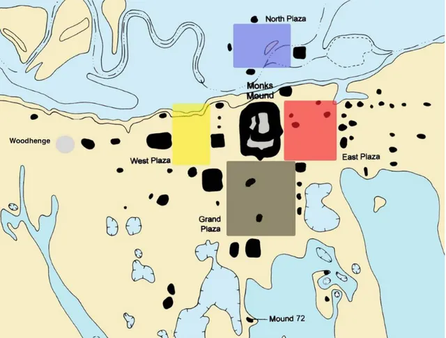
Figure 1.5 General map of Cahokia. The four plazas coloured in blue, black, yellow and red courtesy of J. Kelly.
The North Plaza, bordered by Mounds 5, 13, 14, 15 and 16 was located in the lowest zone of the settlement which is today a swampy area created by the presence of the Cahokia Canal. Since the area was possibly periodically flooded even during the Mississippian times, as the Canteen and the Cahokia Creeks ran in its proximity, the mounds were possibly built during a dry phase. As hypothesized by Byers (2006) and Kelly and Brown (2014), it is possible that the creation of the plaza in that specific location was tied to world renewal rituals, since during the floods the mounds would have symbolically risen from a “primordial sea”. A different scenario, pictured by Iseminger (2010: 99), describes the Plaza as a port of entry for travellers and foreign traders arriving in dugout canoes (fig. 1.6). On the eastern side of Monks Mound, the analysis of the material retrieved from a controlled survey made by the University of Wisconsin-Milwaukee (Benchley 1974) confirmed the presence of an open space between Mound 36 and 51, the East Plaza. This
Figure 1.6 View from the North Plaza. Michael Hampshire, Cahokia Mounds State Historic Site.
open space was relocated after the erection of the Cahokia stockade that surrounded the core of the settlement; at its place the so-called Ramey Plaza was bounded by Mounds 19, 20, 21, 28, 29, 30, 31, 32, 33, 34 and 52. W. K. Moorehead in 1920s tested many of the mounds encircling the area (Kelly 2000) discovering a pre-mound burned structure below Md. 31 and some burials at the base of mounds 19 and 20. J. Caldwell, on behalf of the Illinois State Museum, tested mounds 30 and 31 before they were levelled after the construction of a discount store, locating other pre-mound structures (Iseminger 2010: 106). Still, the most stunning evidences of Cahokia’s life came from the investigations led in 1950s by A. Spaulding (University of Michigan) followed by G. Perino (Gilcrease Foundation, Tulsa). During those excavations, a burned deposit was located on a terrace of Md. 34; this burned area yielded a great amount of material connected to the Southeastern Ceremonial Complex (SECC), such as fragments of engraved marine shells, negative painted pottery, arrowheads and shark teeth (Brown and Kelly 2000). The investigations in the area are still ongoing under the direction of J. E. Kelly and J. A. Brown. Since no detailed maps of the area were produced at the time, their researches focused on the relocation of the trenches made by Perino in 1956 and on the reinterpretation of the archaeological data; they were also able to locate and investigate a copper workshop, already described in 1950s. The results of their work have led to new insights concerning the role of Cahokia in the creation and diffusion of the Southeastern Ceremonial Complex (Brown and Kelly 2000).
TRADITION PERIOD CAHOKIA AREA PHASES Paleoindian 9500-8000 Be Early Archaic 8000-6000 Be Middle Archaic 6000-3000 Be Late Archaic 3000-600 Be 3000- 2300 2300- 1900 1900- 1450 1450- 1100 1100- 600 Falling Springs Titterington Mule Road Labras Lake Prairie Lake Early Woodland 600-150 Be 600- 300 500- 300 300- 150 Carr Creek Florence Columbia Middle Woodland 150 Be-AD 300
150 BC- 50 BC 50 BC- 150 AD 150- 300 AD Cement Hollow Holding Hill Lake Late Woodland AD 300-750 300-450 450- 600 600- 750 Rosewood Mund Patrick Emergent Mississippian/ Terminal Late Woodland AD 750-1050 750- 800 800- 850 850- 900 900- 950 950- 1050 Sponemann Collinsville Loyd Merrell Edlehardt Mississippian AD 1050- 1400 1050- 1100 1100- 1200 1200- 1275 1275- 1400 Lohmann Stirling Moorehead Sand Prairie Oneota AD 1400- 1673 1400- 1500 1500- 1673 Groves Vulcan Historic AD 1673- Present 1673- 1776 1776- 1820 1820- 1880 1880- 1920 1920- Present
Historic & Colonial Indian American Frontier Rural & Urban Urban & Industrial Recent
Chapter 2 The West Plaza: layout and previous excavations
The area located west of Monks Mound, as suggested by Kelly (1996b), functioned during Cahokia’s apogee as the Western element of the quadripartite arrangement of plazas centered on Monks Mound. Its extension is delimited by a series of earthen platforms: the southern side is bounded by Mound 48, 47 and 73; the western and the eastern edges are marked by the presence of Mound 42 (also known as Merrell Mound), Mound 76, Mound 39 (Sawmill Mound), Mound 77, Mound 40 and Mound 41 while the northern edge of the area is delimited by the so called Edelhardt meander, where the Cahokia creek flows (Moorehead 1923; Fowler 1997; Kelly 2000).
The first scientific archaeological investigations in the West Plaza area were conducted by Moorehead during the 1920s (Kelly 2000). In the spring of 1922, Moorehead dug trenches and test pits in Mound 39, also known as Sawmill Mound because of the facility that stood on it in the 1800s and that blew up, killing several workers. Because of the difficulty to measure the too irregular distribution of the archaeological features, no detailed maps were made of the excavations (Moorehead 1929; Fowler 1997; Kelly 2000). Moorehead realized a test trench at the southern slope of the mound where eight burials with associated grave goods were located along with a number of disturbed burials scattered throughout the area. Among the features found, the extended burial, numbered 11 (fig. 2.1), was the better preserved: it yielded two ceramic vessels, which were placed near the right hand of the deceased, and a bowl located near the left knee. Moorehead recorded also the retrieving of a shell gorget and a bone knife. Two other trenches were made on the mound: one located on the east side (10.7 meters wide and 1.5 meters deep) and the other located at the centre (4.3 by 4.6 meters wide and 4.9 meters deep). However, no other burials were found, the test pits yielded a good amount of material: bits of pottery sherds, stone flakes, and a ceramic mammal-head effigy, an awl from a deer jaw, galena, and a human head effigy cut from a freshwater mussel shell. Furthermore, the archaeologist used an auger to probe (1.1 to 1.2 meters) the mound’s stratigraphy discovering that there was a marked series of alternating bands of dark and yellow earth. The dark bands were 7.6 to 25.4 centimetres wide and the yellow bands were 30.5 to 61 centimetres wide. The layers were not even and a conically shaped deposit in the northwest corner of the mound could represent a slope of an earlier construction stage.
At the bottom of all the test trenches and probes made by Moorehead the presence of the widespread natural deposit of heavy black clay layer was attested.
Figure 2.1 Historic pictures of Sawmill Mound’s excavation and burial n°11 (Kelly 2000).
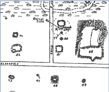
Moreover, Moorehead's proposed that a long, low platform existed between Mounds 39 and 77 directly to the south. On the basis of the good amount of archaeological data and the predominance of black and red pottery, Moorehead suggested that an extensive habitation area – he marked on a general map (fig. 2.2) as “village site” - once surrounded this mound, hypothesis that was later confirmed by the results of 1960s’ excavations.
Figure 2.2 Detail of the West Plaza from general map made by Moorehead in 1923 (adapted from Fowler 1997).
In 1923, Moorehead investigated the small mound 77 located a few meters south of Mound 39. Although the shape he indicated in the 1923’s field report is not very clear, he described it as small and conical mound. Mound 77 appears only on two previous maps
made by C. Thomas in 1894 and by the Ramey family in 1916. On the slope of the mound, he located a circular hard-clay lined pit of ca. 50 cm in diameter, at the base of which he found a 3.6 kg of burned galena, some pottery vessels (a bowl, a jar and a platter) and lithic tools such as hammerstones (Moorehead 1929: 39-40).
It is possible that the clay-lined circular pit described above could have been an offertory basin dedicated to the burials on the south side of the Sawmill Mound that Moorehead described in his 1923 report (Moorehead 1923: 12-14; Fowler 1997). The proximity of the Mound 77 to mound 39, to which was conceivably connected by a platform or terrace and the presence of burials, suggests that Mound 77 was possibly a conical or ridge-top mound and that their relationship could be compared to the one existing between other paired mounds at the site, such as Mounds 59 and 60.
Proceeding on the western edge of the plaza area, the Merrell Mound (Mound 42) is one of the best-preserved mounds in Cahokia. The shape of this platform mound is thought to be close at the one it had during Mississippian times; its excellent preservation could be attributed to the fact that it was never subjected to plowing activities since a house was built on its top for almost a century (fig. 2.3). Mound 42 was constituted by a main rectangular platform mound (79 meters by 122 meters) and an elevated oval platform secondary-mound, of 22.9 meters in diameter, built on its southwest corner. Unfortunately, the oval platform was leveled many years ago, making the entire surface relatively flat.
In 1969, E. Benchley (1974), of the University of Wisconsin-Milwaukee, ran some test excavations. Her research focused on the smaller mounds added during the Moorehead phase on the summit of flat-topped mounds, also known as secondary mounds. Only three examples of these earthworks exist in Cahokia: two were built on Monks Mound’s terraces and a third was added at the top of Merrell Mound. In 1971, the University of Wisconsin-Milwaukee placed test units on the top of Mound 42 in order to define the stratigraphic relationship between the main and the secondary mound, as well as to verify the presence of possible associated buildings; they actually located a Moorehead/Sand Prairie structure on its summit but unfortunately, they could not clarify the relationship between the Merrell and its secondary mound.
Figure 2.3 Mound 42 in the 1920 (Fowler 1997).
Delimiting the north-west corner of the West Plaza area was Mound 76. The location of this small circular mound was determined, as stressed by W. L. Wittry and J. O. Vogel (1962: 28), by the presence, already in the Mississippian period, of a wet area located at north; this resulted in a not perfectly squared Plaza with Md. 76 and its eastern paired, Md. 39, not being aligned. Moorehead mentioned excavations led on top of this mound in its 1923s’ field notes (1923: 47); but there is a chance that the archaeologist was confusing Md. 76 with another one, since he reported the finding of a copper serpent (1929: 9) that was actually found in Mound 59 (Fowler 1997).
Hence, the first to investigate this mound were J. B. Griffin and A. Spaulding from the University of Michigan’s Museum of Anthropology (UMMA) in 1950 (Kelly and Brown 2001); their effort was the first professional non-salvage work in the American Bottom, which implied a careful and controlled method of excavation, since Moorehead’s works at Cahokia.
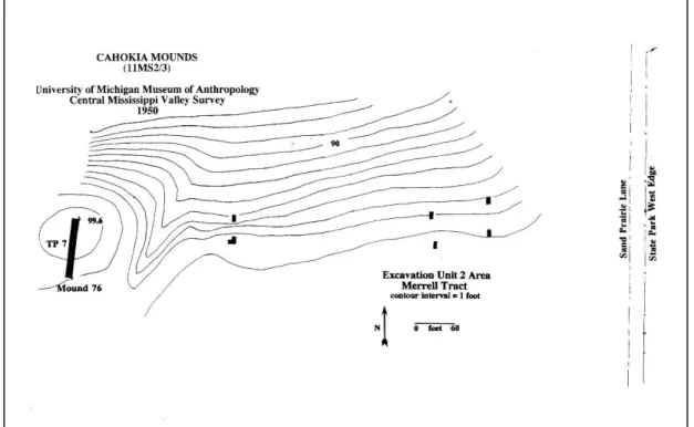
The tests were aimed at a better understanding of the ceramic stratigraphic sequence for the entire site; in their report (Buckles and Griffin 1950), they refer at the seven test pits, made on the mound surface and its proximity, as Excavation Unit 2. Unfortunately, the data retrieved from these tests were inconclusive since most of the units, except the one located on top of the mound, were excavated at a very shallow depth (fig. 24).
Six of the tests, located on the crest and slope of the natural levee, were “in a probable
excavations, the ceramic samples retrieved were mostly from plow zone as the depth of the tests units, as mentioned before, was really shallow.
The seventh test unit was long 28.35 m and was placed on the mound surface. This test unit, deeper than the others, was cut into the mound fill until reaching the submound village fill; unluckily, it was impossible to differentiate between the two strata because “the transition was horizontal and not vertical” (Buckles and Griffin 1950). Even for this unit the results were inconclusive. From a review, made by Kelly and Brown in 2001, of the UMMA’s profile map of Test Unit 7 it emerged that a massive area of fill was added to the natural levee slope in order to extend the surface upon which the mound was later constructed.
Figure 2.4 Map of the 1950’s excavation in the West Plaza area (courtesy of J. Kelly).
Most scholars agree that the Trappist Monks did not build their house upon what we today call Monks Mound (whose name derives precisely from the now debated assumption) and that their settlement could have been located on Mound 48 (Bushnell 1904: 9). This was one of the largest earthworks of the site with its 112m north-south and 111 m east-west, although it was probably a low platform mound since today have a height of 7.5 meters, which is considered very close to the original (Fowler 1997). Moorehead and his workers in 1921 used the farmhouse, which stood on top of the
earthen pyramid, as their headquarter (1929: 33); the house is still visible in one of the air photographs that Lt. G. W. Goddard took in 1922 (Crook 1922).
The first investigations of Mound 48 date back to 1995 when a joint field school from Southern Illinois University-Edwardsville, under W. Woods, and the University of New Mexico, under R. Santley was carried out (Ringberg 1996). By the excavation of nine 2m square test units around the north, east, and south sides of the base of Mound 48 and several cores on its summit, a sequence of natural layers of clay and sand beneath the premound construction surface was detected.
Figure 2.5 SIUE map with location of the test units (from Ringberg 1996).
Moreover, there was evidence of premound stripping of the surface; the stratigraphic analysis revealed that that the mound was built in a single event during the Lohmann phase and showed the possible existence of a ramp on the northeast corner. The three test pits made to the south of the mound showed the presence of pre-mound Emergent
Mississippian house basins, pit and post features, and a possible screen/fence trench. In Unit 9, the ceramic (bowls and beakers) and faunal evidence (mostly deer and fish) located in a midden deposit dated to the Moorehead phase suggests the presence of élite residences located on top of the mound, being the midden the result from the cleaning of the aforementioned buildings (Ringberg 1996: 100). Furthermore, the recovery of Sand Prairie phase ceramic material attests a long occupational sequence for mound 48.
2.1 The 15B Tract
Extensive excavations that changed the concept of what was Cahokia in the Mississippian time took place in 1960s’. During those years, an intense campaign of highway construction in the American Bottom area was under way; this meant that several archaeological sites were endangered since various of the major east-west and north-south interstate highways of the Federal highway system cut through the St. Louis area (First Annual Report: American Bottom Archaeology, July 1, 1961 – June 30, 1962). The improvement of the highway system involved the construction of interchanges and overpasses which required the buildup of thousands of cubic meters of fill to pass over the pre-existent highway, improvement that did not consider the presence of earthen platform or other features.
To face the issue, the Illinois Archaeological survey in cooperation with the U.S. Bureau of Public Roads, United States Department of Commerce and the Division of highways of the state of Illinois Department of Public Works and Buildings decided to establish an Archaeological Salvage Program for Interstate Highway areas. The cooperating institutions worked contemporary in different areas of the American Bottom: the Illinois State Museum Field Parties, under the direction of W. L. Wittry, dealt with the two major areas designated 15A and 15B tract, while the University of Illinois Field Parties, under the lead of D. Lathrap and C. Bareis, conducted the excavation of the area located north of the former Powell Mound and, for the same institution, James Porter directed the fieldworks at the Mitchell site, located seven miles north of Monks Mound.
The first extensive excavations, which did not include the earthen pyramids, were those to the west of Monks Mound. The tracts were named 15A and 15B and their excavation revealed the presence of hundreds of features, such as pits, houses and less common buildings as the Woodhenges in Tract 15A and the sequence of rotundas and compounds in Tract 15B. Before the discovery of these dense occupational areas, scholars thought that Cahokia was a vacant ceremonial center where people gathered only on ritual occasions. Scholars believed that very few people lived sedentary in the center, but the great number of houses and pits found during the 15A-15B excavations showed the contrary; Cahokia was something more complicated than previously thought (Young and Fowler 2000).
The 15B Tract’s excavations were conducted in the area between stations 107/00 and 112/00 (F.A.S. Route 772) and lasted a period of 10 week from August 3 to October 11, 1960; Wittry in cooperation with R.J. Salzer, P. J. Munson and W. M. Hurley directed the fieldworks. As stated before, the realization of the salvage excavation in tract 15B was carried out in concurrence with a Highway Department’s project, which concerned the relocation of Sand Prairie Lane to the west and the construction of an overpass that would carry traffic over I-55 and I-70 (Fowler and Young 2000).
The area to investigate was of almost 5,063.2 m², a great extension that implied the employment of a crew of 17 workers, including a foreman-steward, hired from the S.J. Groves and Sons Company to help the archaeologist in their work. To simplify their work the archaeologists set a grid with which they divided the area in smaller test units, each of them measuring 9x12m and differentiated by a number.