http://disegnarecon.univaq.it
Pasquale Tunzi
Associate Professor of Ar-chitectural Drawing at the University of “G. d’Annunzio” Chieti-Pescara. He was coor-dinator of the Art and Design Department in the School of Specialization in Secondary Teaching (SISS) for the “d’An-nunzio”. He collaborates with the Archival Superintendency for Abruzzo and with the State Archives of Pescara and Chieti for which he has curated exhi-bitions and publications.
Constantinople viewed by the Renaissance-era West
This study revolves around a reading of the main
aspects of how Constantinople was depicted by
Western scholars during the Renaissance. The
illustrations considered as a semiotic system are
bird’s-eye views of the city in printed works, done
from 1420 to the late sixteenth century. From a
sizable specific documentary
corpus, bird’s-eye
views were selected where the characteristics
of the environment and buildings were easily
visible. We consider the ways this major trade
centre, the linchpin between East and West with
frequent contacts with Genoa and Venice, was
depicted. As for visual culture, the study draws an
analysis – graphic and geometric, social and
tech-nical – of these illustrations chronologically,
com-paring them with other city images from the
peri-od, and maps, to comprehend the mechanism of
urban depiction during the Renaissance. The
re-lationship of similarity was considered to define
the iconic system’s operation in relation to the
Keywords:
Iconography; Constantinople; Renaissance;
visual culture; city images
real one. Depictions of Constantinople are taken
as a paradigm of a form of communication
typi-cal of the time, when the city was the engine for
activity of all kinds. Nor are the makers of these
images neglected: cartographers, draughtsmen,
early archaeologists, engravers, printers, artists
and travellers – true protagonists in a season
abundant in cultural manifestation.
http://disegnarecon.univaq.it
1. INTRODUCTION
In Enciclopedia dell’Arte Medievale, the entry Città, by Paolo Cuneo (1994), opens with a quotation from Book XV of Isidore of Seville’s (560-636) Etymolo-giae, distinguishing civitas from urbs. To provide visual substance to the idea of society protected by walls, the various iconographical referenc-es include a miniature contained in Prima Bibbia di Carlo il Calvo (846 AD), depicting St. Jerome’s journey from Rome to Jerusalem. In the central part, the specific image shows a polygonal belt of merloned, turreted walls seen from above, with a scene of monastic life taking place inside (fig. 1). This depiction, typical in concept to Roman classicism, can be found in a section of the bas reliefs wrapping around Trajan’s Column in Rome (113 AD) (fig. 2). Taken in the conven-tional sense, this figurative expression was fol-lowed in the Middle Ages and beyond, adjusting to the needs of the times. This archetype – the bird’s-eye view of the city – was never to be dis-regarded, as it was the form most illustrative for an aggregate of constructions and spaces.
“For centuries, and throughout the Middle Ages, the idea had taken root that the city was the centre of world domination, destined to last into eterni-ty,” maintains Chiara Frugoni (1984), and images were tasked with displaying the power of those who administered them. Their communicative function displayed two aspects: on the one hand, the ability to educate, and on the other the apti-tude for acquiring more knowledge.
Cartographers and miniaturists were thus the makers of new depictions – the former metrical-ly defining state boundaries, and the latter illus-trating cities as symbols of civilization and pow-er. Juergen Schulz (1990) broke this production down into two categories: maps and layouts for cartographic-topographic purposes; and views and maps suited for teaching purposes. Of course, between the former, technical ones and the lat-ter, artistic ones, a boundary is not always easy to draw, because, especially in the Middle Ages, historical and geographical elements were lost in an aura of symbolism.
The outlined cultural landscape is interesting [1], and we draw from it the printed depictions of
Con-Fig. 1 - Excerpt of the miniature, Bible of Charles the Bald: stories of St. Jerome, 846 approx (Archivio Scala Group, Firenze, id 0004383).
Fig. 2 - Trajan’s Column (113 AD) excerpt of the graphic relief relating to the imprisonment of the Dacians (Colonna Traiana. Corpus dei disegni 1981-2001).
Fig. 3 - F. Foresti, Supplementum Chronicarum orbis ab initio mundi, Con-stantinopolis thracie urbs, Venetiis, 1486 (Bibliothèque nationale de France).
Fig. 4 - F. Foresti, Supplementum Chronicarum orbis ab initio mundi Citta de Constantinopoli, 1492 (Bibliothèque nationale de France).
http://disegnarecon.univaq.it
stantinople disseminated during the Renaissance, a crucial time for this capital considered the lin-chiping between East and West. After eleven cen-turies of prestige, the “New Rome,” beautiful and rich, began its twilight phase, declining from Ro-man to Turkish power in the mid-fifteenth century. 2. EARLIEST PRINTED IMAGES OF THE CITY The interest in classicism in the Renaissance led Italian culture to rediscover works such as Claudius Ptolemy’s Geographia, printed in Lat-in Lat-in Florence between 1406 and 1410, with the title Cosmographia (Bifolco, 2014). This work was brought to Florence by Byzantine human-ist Manuele Crisolora when he arrived there in 1397 to teach Greek; Iacopo Angeli da Scarperia oversaw its publication.
The prized manuscript known also as Codex Vati-canus Latinus 5699 includes, in its appendix after the maps, nine plans of cities of the East and West, featuring Constantinople [2]. Concise and symbol-ic, these depictions aim to underscore more their historic value than their topographical meaning. In the printed text, the first depictions of cities appear in Chronicon, chronologically arranged historic narrations [3]. In Italy, Supplementum Chronicarum orbis ab initio mundi [4] by the Bergamo monk Giacomo Filippo Foresti, collects small-format images of cities of Europe and the Middle East. Also included is an early depiction of Constantinople (fig. 3) which, however, as we leaf through the volume, we find to be wholly approximative, since we find identical versions bearing the names of Epidaurus, Mytilene, Gae-ta, Pisa, and other cities. In the fourth book, an oblique aerial view depicts Constatinopolis thra-cie urbs as a dense, built-up area girded by tur-reted walls overlooking the sea. On the right, a drawbridge links it to a strip of land marked by a turret; on the left, the polygonal enclosure is strengthened by an imposing, multilevel circular tower, perhaps a lighthouse. In front, a portion of wall extends into the sea, forming a pier where two large vessels are docked.
These generic elements are meant to refer to
Constantinople, but clearly lack its strength. They underscore the trading city’s importance with an imagined depiction comprising a vision common to many Italian cities. Supported by citations of an-cient authors, the text mentions the “magnificen-tissima edificia Sãcte Sophie templum Justiniani”; but the image does not show a domed construc-tion whose traits might refer to the precious, im-posing monument. Instead, we see a three-naved church with a roof that might be the one built by Theodosius II in 415, destroyed by fire during the Nika riots in 532. But although not very true to the text, the image expresses Isidore of Seville’s con-cept of the city, and the caption makes the subject. This is demonstrated by the edition printed in Venice in 1492 by Bernardino Rizzo; Foresti re-places that image with another in which the city of Constantinople (fig. 4), in an oblique aerial view, is virtually circular in shape, densely built up and gathered inside turreted walls. The surrounding barren, hilly landscape is dotted with small for-tresses overlooking a corner of the marina on the
Fig. 5 - H. Schedel, Liber Chronicarum, Costantinopolis, Nuremberg, 1493 (Biblioteca Queriniana, Brescia).
lower left of the picture. A small port with some vessels, it is unfortunately not enough to contex-tualize the city of Constantine, whether through buildings or the use of symbols.
It is also to be borne in mind that the image’s title, Citta de Constantinopoli, is still placed out-side the frame of the view, and this device al-lowed it to be replicated and inserted elsewhere in the text to indicate another city. We rediscover it accompanying later additions, and in the exten-sion to the Supplementum Chronicarum, printed in Venice in 1503 with the title Novissime hysto-riarum omnium repercussiones.
As Rinaldi (1989) points out, the elements mak-ing the city recognizable are monuments, whose evocative analogon permits the recollection of events, a simulacrum whose equivalence to the original can contain “the material and symbolic truth.” But this does not occur with Foresti, whose images are only an interlude to lighten rather than document the text. But the little relation they bear to reality was not a relevant factor for the reader
http://disegnarecon.univaq.it
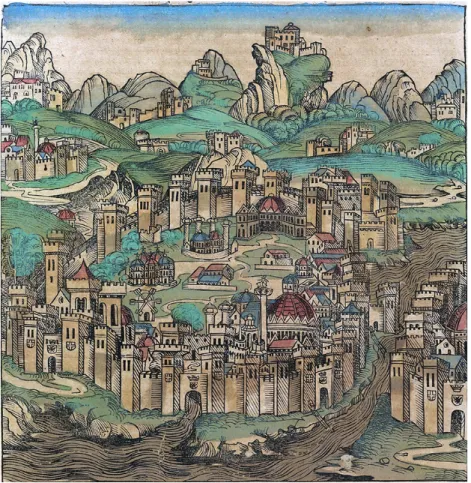
at the time, for whom the image carried the con-notation of a diagrammatic icon, a sort of simple “sign” placed for reference in the narration. The following year, in 1493, German human-ist Hartmann Schedel accompanied his Liber Chronicarum [5], printed in Nuremburg, with two images of Constantinople – woodcuts by Michael Wolgemut [6] – that were quite larger than the earlier ones. One comments upon Constantine’s work (fig. 5), while the other depicts when the city was conquered by the Turks in 1453. The two images do not actually differ greatly, although their formats are distinct and, at any rate, in the city’s clear recognizability, deviate from Fores-ti’s depictions. What was to live significantly over time was their way of giving its real elements to the fixity of the image.
The bird’s-eye view shows a large circuit of tur-reted walls opened at the centre by a city gate from which the Lykos river flows. Not far to the right is the Golden Horn [7], delimited by the shore of Pera. These two elements are our refer-ence for defining the vantage point from which the city was depicted, and a nineteenth-century topographic map supports this. Here we see that the Lykos flows into the Sea of Marmara, quite far from the Golden Horn; we therefore deem the draftsman’s hypothetical vantage point to be the open sea, to the south. In actuality, since it is im-possible to see the mouth of the Lykos and the Golden Horn simultaneously, a depiction from the east as supposed by Berger-Bardill (1998), imagined as from the coast of Bithynia, is not possible. We therefore believe it is not a portrait, which supposes direct observation, but a prede-termined figuration done perhaps on the basis of the sketches made aboard a ship [8]. The image of Constantinople is thus considerably contract-ed in length and, given the vicinity of the Golden Horn, its “triangular” shape is missing [9]. Inside the walls is a slightly rugged territory marked by dirt roads and well characterized fea-tures: Hagia Sophia with its large dome set on a merloned octagon and topped by a lantern, the Column of Justinian beside it. Slightly to the left are the ruins of the old imperial palace, located
behind the sea gate from which the Lykos flows. Behind the ruins is the five-domed Church of the Holy Apostles, and on the right stands a building with two wings and a central dome behind the Pal-ace of Blachernae or of Constantine.
In the background outside the city are mountain reliefs; Pera with some towers may be glimpsed to the right, with a vessel with lowered sail on the left. Each element appears to take on a precise physiognomy in a balanced, proportionate figura-tive context. But it is a strange image if consid-ered in geometric terms: although it is an aerial
Fig. 6 - H. Schedel, Liber Chronicarum, De expugnatione Constantinopolis, Nuremberg, 1493 (Biblioteca Queriniana, Brescia).
view, the masonry curtain reinforced by numer-ous, imposing square towers is shown from be-low: neither the towers’ roofs nor the walkways between them can be seen. Starting from the central city gate, the towers on the left that, in succession, gird the rear portion of the city show a shaded front and a right side in the light, until reaching, on the upper right, the Palace of Con-stantine overlooking the Golden Horn. The other towers to the right of the gate are arranged fac-ing the light, with the left side shaded. This way of shading the buildings provides the sensation
http://disegnarecon.univaq.it
of three dimensions and arrangement in space. Moreover, the care given to details, both architec-tural and of context, distracted the draughtsman from defining the actual situation.
The second image (fig. 6) depicts the city in a more circular shape conditioned by the size of the nearly square engraving plate. This forced the artist to give more attention to the larger space of the countryside dotted with small villages set in relation to the big city.
The urban architectures are the same, and the type of representation is identical, although the graphic treatment is more approximative. In the former case, the graphics adopted for the walls clearly suggest a regular, brick texture, a detail
Fig. 7 - C. Buondelmonti, Liber insularum Archipelagi, Costantinopoli, Cod. Lat. X, 123, 1422 (Biblioteca Marciana).
Fig. 8 - C. Buondelmonti, Costantinopoli, 1480 (Düsseldorf Universitäts-und LandesbibliotheK, ms G.13).
Fig. 9 - C. Buondelmonti, Costantinopoli, 1422 (Bibliothèque nationale, Paris).
that surprised Ciriaco d’Ancona when he visited the city in 1418 [10]. Some buildings and ruins are now absent, and Pera is hardly more visible on the right, with its turreted wall enclosing within it several constructions as well as a barely notice-able domed building. Confirming the dearth of relationships of scale among the various parts of the composition, this second image merely re-states what is in the previous figuration, but pro-vides a sense of extreme calm, of the absence of commercial activities due to the lack of vessels. In both engravings, the artist’s shrewd hand has intensified the graphic treatment in the lower part of the image, leading the observer’s eye to dwell on the various details in spite of the upper portion
where the marks are lighter and sparser.
As concerns the architectural quality expressed in the two images [11], we must also refer to what Berger & Bardill (1998) pointed out for religious buildings, which reflect “the pictorial conventions of the contemporary art of Western Europe.” We may agree with this consideration, especially in that these images are not to be taken as a “source of ar-chitectural details.” But we disagree with likening these figurations to that by Giovanni Andrea Vavas-sore, to be discussed below, since we find no ex-plicit points in common. The great value they have is confirmed, since the first images of Constanti-nople adhere particularly to the reality of its places and to its topography and historical meaning.
http://disegnarecon.univaq.it
3. PRECURSOS OF URBAN ILLUSTRATIONS In 1403, Ruy González de Clavijo, ambassador of Henry III of Castile, significantly described the appearance of the capital of the Eastern Empire: “The city of Constantinople is well girt by tall, imposing walls and great, strong towers (…) and although a large, fortified city, it is not very popu-lous because at its centre are many hills and val-leys with fields planted with wheat and vineyards, and a host of vegetable gardens; these include the neighbourhoods of dwellings (…). This city has many large buildings and churches and monas-teries, most of which in ruins, and it seems clear that in other times, when it was flourishing, it was one of the world’s noble cities. Between small and large ones, three thousand churches are said to be in this city (…)” (1859).
Clavijo’s words accompany Schedel’s images, providing specificity of use for better reading and outlining an overall picture. The large stretches of countryside farmed inside the walls appear to be the cause of the low population of some still inac-cessible areas, in spite of the numerous houses of worship. However, what struck the ambassador at
Fig. 10 - Paolino da Venezia, Chronologia Magna, Roma, ms Lat. Z, 399, 1346 (Biblioteca Marciana).
Fig. 11 - F. Foresti, Supplementum Chronicarum, Costantinopoli presa & saccheggiata da turchi, 1535 (Bibliothèque nationale de France).
first glance was the city’s fortified appearance, as stressed by Schedel.
Until the late fifteenth century, the image of Con-stantinople had no distinctive topographic or iconic character. Several depictions related to the Turkish siege in 1453, a disturbing event of great interest for political as well as economic reasons. And other rare, wholly approximative images may be found in certain manuscripts, like the Luttrell Psalter of 1325-1340, and the codex Roma parte del cielo. Confronto tra l’Antica e la Nuova Roma done by Manuele Crisolora in 1411 [12].
The starting point for a reliable depiction of Con-stantinople arrives with the Florentine Cristoforo Buondelmonti when, in 1415, he plied the Medi-terranean, attracted by the Greek cities’ antiqui-ties. His interests were certainly piqued by the classical, humanistic culture that was developing, as discussed, in Florence during that period, con-currently with the proto-archaeological climate that Ciriaco d’Ancona was helping to spur after his journeys in the Mediterranean [13].
Attributed to Buondelmonti or copied from his first depiction of Constantinople (figg. 7-8-9) is a series of drawings that Giuseppe Gerola (1931)
states are similar but “clearly differ from one another”. Some are sufficiently complete, wa-tercoloured, or left in pen strokes; others appear to refer to certain elements of the place, while neglecting many details.
We will not attempt a specific study of these drawings here; they deserve discussion of their own, as they are numerous and certainly inter-esting, also in light of recent studies. These views will be a reference for us, as concerns what was produced through printing.
A comparison of the engravings observed thus far with the views done by Buondelmonti and by the copyists for Liber insularum Archipelagi in 1422–1453 would yield numerous differences. First, the latter depict the extremity of the Balkan peninsula, Thrace, in its proper geographic orien-tation, with Pera north of the Golden Horn water-way, and the shores of Anatolia on the right of the image, as shown by Ptolemy in his map. The city,
http://disegnarecon.univaq.it
compatible modes of depiction. A careful reading of the not inconsiderable number of reproductions raises suspicions of a lack of interest in the lived-in space, although the aim was to provide a reli-able image of it. In fact, the main element is the peninsula’s outline, close to the real one that may be traced in the maps made by Piri Reis in 1513. What is contained within the masonry wall, on the other hand, is almost disseminated, with no clear relationship among the various constructions, and lacking a proper structure. The only fixed ele-ments are the Hagia Sophia with the hippodrome in front, at times incomplete, and the port of the Emperor’s Palace. This means that every image
Fig. 12 - G.A. Vavassore, Bizantum sive Costantineopolis, 1535 approx (private collection).
as if an enlargement of that strip of land, is hur-riedly drawn within the circuit of turreted walls, rather flat, surrounded almost entirely by water. In a sort of aerial view, it is dotted with various elements inside: Hagia Sophia, the Hippodrome, the Imperial or Blachernae Palace, five columns (two of which spiral columns), a few, scattered houses, and some churches and towers, with es-sential roads: buildings not always positioned with the same precision in the various maps, that are at times enriched with details, and at times dis-appear altogether [14]. For the northern area as well, the construction is in some cases intensified, and rather bare in others.
The depiction, whose origins lie in the aforemen-tioned ancient iconography, refers to the images of Rome made in the fourteenth century, recall-ing that contained in Paolino Minorita’s Chrono-logia Magna of 1346 (fig. 10). A perimeter of walls detaches a group of representative buildings, and some environmental details due to reliefs, from the rest of the world. Thus, in the depictions of Constantinople, a string of towers girds the ex-tremity of the Balkan peninsula, in the shape of a considerably rounded triangle pointing east. To the northwest, it is connected to the territory by a small strip of land and thin bridges. On that side, a double wall is flanked by a large channel full of water, built by Theodosius to defend the city from barbarian invasions.
Roads are not always shown. The same may be said for the nomenclature accompanying the buildings. All the depictions lack perspective and foreshort-ening; the buildings are all of the same propor-tions, shown in an intuitive axonometry able to dif-ferentiate them by bulk and shape.
In this semiotic system, the images provide the historic appearance of the pre-existing ancient elements of Constantinople, rather than the geo-graphic situation. These are ground plans upon which the three dimensions of the buildings are overlaid, simulating a sort of bird’s-eye view pro-viding an overall vision. For Alessandro Rinaldi (1989), illustrations of this kind show a “univocal and ingeniously content-based use,” due precisely to the simultaneous presence of two, not wholly
is a repertory of discrete units in which possible rules for producing meaning are found.
However, for the time, it is a unique and incontro-vertible depiction: as mentioned, we find it included in Ptolemy’s Geographia in 1469, in Codex Vatica-nus LatiVatica-nus 5699, and in Codex Urbinas LatiVatica-nus 277 in 1472, demonstrating its iconic value and the urban figurations’ great importance on the geo-graphic landscape. Moreover, the various copies made by eye on the Buondelmonti “prototype” as early as 1428 [15] underscore the Western idea of documenting a complex historic reality (Manners, 1997). But this was not enough to take it as a model for later depictions – which, however, could not
http://disegnarecon.univaq.it
neglect it. For Buondelmonti, the depiction of Con-stantinople was certainly the completion of the text, the window from which the vestiges of the ancient culture produced by the West could be admired. 4. SIXTEENTH CENTURY ENGRAVINGS OF CON-STANTINOPLE
We leave handmade depiction, returning to print-ed images of Constantinople producprint-ed in Europe. It is again Filippo Foresti who provides a new im-age of Constantinople (fig. 11) in the 1535 edition of Supplementum Chronicarum.
In this small image at the bottom of the text, the city of “Constantinople seized & sacked by Turks” is shown from the east in the triangular physiog-nomy of the peninsula flanked by the Golden Horn waterway to the right. It is not a historic scene as the title indicates, but a tranquil, oblique aerial view concisely depicting the walls reinforced by towers, with few constructions inside. Its unique-ness or figurative novelty lies in presenting the tip of the peninsula in the position it would symboli-cally take at a later time. The Bosporus is plied by vessels of varying cabotage, and there are even gondolas in the Golden Horn. The graphic treatment highlights the water with dense cross-hatching, in chromatic contrast with the white, inhabited territory. The illustration is closed by a chain of mountains near the upper edge.
It is an image decidedly at odds with what we have seen, and in certain ways quite close to the physical state of the places, in terms of general physiognomy. The cartographic representation has quickly travelled its path, acquiring many important experiences, also in the field of sur-veying [16]. And cartography, like that produced and updated by Piri Reis in the early sixteenth century, made it possible to see the territory dif-ferently in its specific nature.
In this case, however, the city does not present its typical constructions, and in particular it loses the domed emblem, the Hagia Sophia, replaced by a large church with a campanile. Many other historic buildings are also missing; only one of the columns remains. Roads – and above all the commingling of
others even later – an uncertainty that has made it impossible to define whether it was a reference to Foresti’s earlier engraving, or the other way around[17]. However, although their graphic and figurative quality differ quite greatly, the two im-ages bear many similarities.
The city is now densely built up; the monuments do not predominate in the enclosure’s space; a series of writings in cartouches helps identify the places and buildings, as occurred for some of Buondel-monti’s images. Although the depiction of space has yet to acquire perspective, similarity makes things visible, and extremely precise in their de-tails; Arne Effenberger (2016) in fact wonders: who had the opportunity to explore the city in all its points, even in places like seraglios that required sacred and profane places – are lacking. One has
the feeling of having acquired the right physiog-nomy of the city, to the detriment of the intrinsic traits that made it recognizable for its illustrious past. Geography almost appears to have under-mined history, and space to have shaken off time. In any event, the Italians were to determine this image as representative, and to say it with Fou-cault (1978), it was to be the “marked form,” due to the similarity to the geographical place: the model for subsequent depictions of Constantino-ple. We find it seen to in minute detail in the larger engraving “Bizantium sive Costantineopolis” (fig. 12) by the Venetian Giovanni Andrea Vavassore (“Vadagnino”) during those same years. Some scholars date it to 1520, others to 1535, and still
http://disegnarecon.univaq.it
Fig. 14 - G.F. Camocio, Isole famose, porti e fortezze, Costantinopoli, Venetia,1566 (Biblioteca Marciana).
permission to gain access? There is currently no certain indication of the prototype’s author. As the same scholar maintained, all subsequent copies of Vavassore’s view show a series of licenc-es or of “gratuitous elements” in various points of the city, typical of the Venetian engraver, that set it apart. It is a precious update of the city relating to what occurred after the Turkish conquest. But with all its imperfections, it remains an ex-cellently made document, and Constantinople attains its iconic image to be handed down for a long time, to which European writers, engravers, and publishers would adhere.
In 1550, Sebastian Münster inserted it into the fourth book of Cosmographia universalis with a long caption at the bottom. Differing only in its essential graphics was La Ville de Constatinople (fig. 13) by French typographer Guillaume Guéroult, accompa-nying 1553’s Épitomé de la corographia d’Europe. In 1564, Antoine Du Pinet would frame this im-age with telamons and cartouches to occupy two pages of Plantz, pourtraitz et descriptions de plu-sieurs Villes et Forteresses, anticipating by two years the publication by the Venetian Giovan Fran-cesco Camocio, who re-engraved the view (fig. 15), endowing it at the bottom with a compass rose and an ample, 60-entry alphabetical legend.
Paolo Forlani and Donato Bertelli worked at the Ca-mocio printing house; we have two of their engrav-ings of Constantinople virtually equal to the first: one used by Giulio Ballino for the collection De’ disegni delle più illustri città e fortezze del mondo printed in Venice in 1569. Copies were included in 1570, in the Claude Duchet printing house, and in 1575 in Antoine Lafrery’s production in Rome. A relative update of Vavassore’s view is in the monumental work Civitates orbis terrarum by George Braun & Franz Hogenberg in 1572, in which “Bizantinum nunc Constantinopolis” (fig. 15) no longer has a legend of names at the bot-tom, but twelve tondi with depictions of sultans, with Muhammed on horseback in between, sur-rounded by a group of janissaries.
That same year in Venice, Tommaso Porcac-chi opened his Descrittione di Costantinopoli in L’isole più famose del mondo, with Girolamo
Porro’s engraving drawn from Duchet, without the legend (fig. 16).
We find Camocio’s version, with the same graph-ics, fewer vessels, and a legend at the bottom in Simon Pinargenti’s 1573 atlas Isole che son da Venetia nella Dalmatia. Lastly, a few variations would be introduced by the engraver Giacomo Franco in 1598, in order to include it in Viaggio da Venetia a Costantinopoli per mare by cosmogra-pher Giuseppe Rosaccio (fig. 17).
Only in 1635 would the German Matthäus Merian produce a panoramic view of Constantinople ex-tending over the Bosporus.
5. CONCLUSIONS
The map creates a close link between man and a piece of the world. Evely Edson (1997) believes that in the Middle Ages, the Earth was perceived as an object the viewer had to grasp. Direct per-ception bears witness to existence, and Medieval figuration tells a story the individual takes part in. Doubtlessly, the various depictions of ancient Istanbul are a cultural construction, the key to defining, fixing, and transmitting its points of identity. Proof of this is the at times slavish rep-etition of its image, reinforcing the idea of power,
http://disegnarecon.univaq.it
Fig. 17 - G. Franco, Costantinopoli, in G. Rosaccio, Viaggio da Venetia a Costantinopoli per mare, Venezia, 1589 (Biblioteca Marciana). Fig. 15 - G. Braun, F. Hogenberg, Civitates Orbis Terrarum, Bizantum nunc
Constantinopolis, Colonia, 1572 (Biblioteca Marciana). Fig. 16 - T. Porcacchi, L’isole più famose del mondo, Descrittione di Costanti-nopoli, Venetia, 1572 (Biblioteca Marciana).
even at the cost of proving false or unreliable in comparison with actual, physical reality. But they clearly contain the cultural reality of the times when they were produced, passing from a con-ceptual to a realistic figuration, from the political power of the West to that of the East, although some signs of the former remain.
Seeing them in cross-section, we may grasp the rapid evolution of the urban depiction, the concep-tions relating to the city and the ways of record-ing them. The symbolic city is now the measured city. In the Renaissance, accuracy and precision – requirements earlier irrelevant in iconic value – acquired, with perspective, the truthfulness of the image understood as analogon.
Filippo Foresti is to be credited with opening the printed text to the urban image, the attempt to give the reader another opportunity for knowl-edge and exchange. Buondelmonti, for his part, overcomes the eminently symbolic aspect of the urban image, supporting it with topographical knowledge, a tangible sign of the changed views in Western culture. And with Vavassore, Constanti-nople would attain its figurative recognizability, to be enlarged with the first panorama drawn in 1559 by the German Melchior Lorichs.
None of the images of Constantinople shows the city from inland towards the sea because, as oc-curs for other coastal cities, water is the distinc-tive and fundamental element, both visually and in terms of sustenance. Constantinople is reached not by land, but by sea.
http://disegnarecon.univaq.it NOTE
[1] We remember the contribution of Francesco Petrarca to the dis-semination of ancient geography texts with important footnotes, as remembered by Sebastiano Gen-tile in Umanesimo e scienza anti-ca, in Il contributo italiano alla sto-ria del Pensiero, Scienze, Treccani, 2013. It is also worth mentioning the poet from Arezzo, an expert geographer and tireless traveler, Itinerarium Syriacum written in 1358, in which he says of Constan-tinople that the Greeks define it as a second Rome, greater in wealth and buildings. Also interesting is the attribution to the poet of the Pictura Italiae, cited by Flavio Bi-ondo in 1474, a work discussed in the first half of the twentieth cen-tury by some scholars.
[2] See the image on the website https://digi.vatlib.it/view/MSS_ Vat.lat.5699, 127v, consulted on July 10, 2020.
[3] This literary genre, originating with certain Mediterranean peo-ples in remote times, saw new life in the Middle Ages; the first handwritten texts include St. Je-rome’s, composed in Constantino-ple around 380 AD. In the second half of the fifteenth century, thanks to typesetting technology, this and other manuscripts, accompanied by miniatures, enjoyed greater circulation and were enriched with illustrations, a sizable number of which included cities.
[4] The book in folio, printed by Bernardino Benali in Venice in 1482, is a history of the world told chronologically in fifteen books. [5] chapters called “ages.” This subdivision originates from St. Au-gustine’s writings in 400 AD; Nuo-va Cronica, written in 1322 by the
Florentine Giovanni Villani, was the literary genre of reference. [6] The text was accompanied by 1,809 woodcuts also done by Wilhelm Pleydenwurff and by the twenty-year-old Albrecht Dürer, commissioned by the printer An-ton Koberger in 1487.
[7] The Golden Horn was the safe harbour until the late nineteenth century. A distinctive element in the image, is the presence of two large chains anchored to the en-trance of the waterway, and the other about halfway in. They were installed in 718 by Emperor Leo III to protect against the Arab siege. For centuries, Venetian and Geno-ese merchants who had settled the banks managed the Golden Horn. Galata – or Pera – on the northern bank was a Genoese quarter. [8] It may be supposed that Schedel saw Ciriaco d’Ancona’s sketches when visiting Veneto be-tween 1463 and 1466. He certainly tapped Commentaria for a series of drawings. Cf. G.B. De Rossi, Dell’Opus de Antiquitatibus di Hartmanno Schedel Norimbergese, in Memorie dell’Instituto di Corris-pondenza Archeologica, v.2, Lipsia: Brockhaus, 1865, p. 507. [9] In La città europea, il Saggia-tore, 2010, Cesare De Seta main-tains that the image of Constan-tinople is the first reliable one, while Evely Edson (1997) deems the text a collection of stories on the great cities of the West and on the most important events. [10] From the memoirs of Frances-co Scalamonti written in 1464, ms I, 138 Biblioteca Capitolare di Treviso. During that visit, Ciriaco d’Ancona made many sketches which were quite likely taken as a reference by Giuliano da Sangallo around 1500,
REFERENCES
Berger, A., & Bardill, J. (1998). The Representations of Constantino-ple in Hartmann Schedel’s World Chronicle, and Related Pictures, in Byzantine and Modern Greek Studies, 22 (1), 1-37.
Bifolco, S., & Roca, F. (2014). Car-tografia rara italiana: XVI seco-lo. L’Italia e suoi territori. Roma: Edizioni Antiquarius.
Edson, E. (1997). Mapping Space and Time. How Medieval Mapmak-ers Viewed their World. London: The British Library.
Effenberger, A. (2016). Konstantino-ple/Istanbul – die frühen bildlichen Zeugnisse. In Daim Falko (Ed.), Die byzantinischen Häfen Konstantin-opels (p. 19-34). Mainz: Romish Germanisches Zentralmuseum. Foucault, M. (1978). Le parole e le cose. Milano: Rizzoli.
Frugoni, C. (1984). L’antichità: dai Mirabilia alla propaganda politica. In S. Settis (Ed), Memoria dell’an-tico nell’arte italiana, (p.53). T. 1, L’uso dei classici. Torino: Einaudi. Gerola, G. (1931), Le vedute di Costantinopoli di Cristoforo Buon-delmonti, in Studi Bizantini e Ne-oellenici, v. III (pp. 249-279). Roma: Stabilimento Tipografico R. Garroni. Manners, R. (1997). Construct-ing the Image of a City: The Rep-resentation of Constatinople in Christopher Buondelmonti’s Liber Insularum Archipelagi, in Annals of the Association of American Gepg-raphers, 87 (1), 72-102.
Rinaldi, A. (1989). La formazione dell’immagine urbana tra XIV e XV secolo. In D’une ville à l’autre. Structures matérielles et
organisa-tion de l’espace dans les villes eu-ropéennes (XIIIe-XVIe siècle) Actes du colloque de Rome (pp. 773-811). Rome: École Française de Rome. Ruy González de Clavijo, R. (1859), Narrative of the Embassy of Ruy González de Clavijo to the Court of Timour at Samarcand A.D. !403-6. London: Hakluyt Society. Schulz, J. (1990). La cartografia tra scienza e arte. Modena: Franco Cosimo Panini.
and by Mantegna. Cf. C. Hülsen, Il libro di Giuliano da Sangallo. Codice Vaticano Barberiniano lat. 4424, Leipzing, 1910; M. Vickers, Mantegna and Constantinople, in The Burlington Magazine, v. 118, n. 883, 1976, pp. 680-687. [11] In Schedel’s Liber Chronicar-um there is a third image of Con-stantinople that we do not take into consideration, because it does not wholly embrace the city. An-other bird’s-eye view, it shows the city after the devastating storm of 12 July 1490, as reported by Arne Effenberger (2016).
[12] The highly concise image de-picts Rome within a polygonal wall with pointed towers surrounded by a water-filled moat; beside it is Constantinople, depicted with tri-angular walls reinforced by towers, also surrounded by water. [13] D’Ancona made his first jour-ney to the Near East from 1412 to 1414. He visited Constantinople in 1417, thus during the same years when Buondelmonti was travelling in the Aegean and landed in Con-stantinople in 1422. Cf. M. Vickers, Mantegna cit. We also point out that D’Ancona penned numerous sketches of Constantinople in 1418, including an eloquent ax-onometric section and a prospect of Hagia Sophia from above. [14] The interesting essay by Manners (1997) updates Giuseppe Gerola’s research, comparing the study of other unpublished views of Constantinople by Buondelmonti. [15] Gerola (1931) recalls that “six years after the work’s end – the copy done at Chios is documented (currently at the Holkham Library), while another apograph (now at the Marciana)” bears witness to the work’s great spread.
[16] It is worth recalling the inter-esting Descriptio Urbis Romae ex-perience conducted by Leon Bat-tista Alberti around 1450, whose numerical data, without image, are the first example of an urban reality translated into figures, so much so as to suggest a new cul-ture of the image. Leonardo, on the other hand, as we know, in 1502 translated his numbers recorded on the city of Imola into a splendid map already mentioned by Danesio Maineri in 1473.
[17] On the initial model Vavas-sore is presumed to have drawn from, it has been thought it was a large-format engraving done in the early sixteenth century by the Flor-entine Francesco Rosselli, accord-ing to the inventory of the cartog-rapher’s assets. But this engraving has never been found. Another hypothesis regards a large-format engraving by the Florentine Lucan-tonio degli Uberti done in the first quarter of the sixteenth century. Cf. Effenberger, A. 2016.