POLITECNICO DI MILANO
Scuola di Ingegneria Industriale e dell’Informazione Corso di Laurea Magistrale in Ingegneria Informatica Dipartimento di Elettronica, Informazione e Bioingegneria
A method for predicting the
performance of SLAM algorithms
Relatore: Prof. Francesco AMIGONI
Correlatore: Dr. Matteo LUPERTO
Tesi di Laurea Magistrale di: Valerio CASTELLI, matr. 853992
Ringraziamenti
Questa tesi `e il punto di arrivo di un percorso lungo, iniziato quasi sei anni fa e che da allora si `e sviluppato attraverso una serie di circostanze diverse e talora inaspettate. Ma soprattutto, `e l’ultima tappa di un viaggio che ho condiviso con tante persone, vicine e lontane, senza le quali non sarei mai arrivato dove mi trovo oggi. `E quindi giusto e doveroso iniziare questo manoscritto ringraziandole dal profondo del cuore per essere state al mio fianco in tutti questi anni.
Voglio innanzitutto sentitamente ringraziare il Prof. Francesco Amigoni e il Dott. Matteo Luperto per tutto il tempo ed il supporto dedicatomi durante lo svolgimento di questa tesi. Ho imparato molto da loro, sia stilisticamente che umanamente, ed i loro suggerimenti e consigli sono stati punti di riferi-mento fondamentali per lo sviluppo di questo lavoro.
Ringrazio inoltre il Prof. Matteo Matteucci ed il Prof. Andrea Bonarini per avermi permesso l’utilizzo di Robocom e del laboratorio AIRLab per le prove sperimentali, nonch´e l’Ing. Giulio Fontana e il Dott. Enrico Piazza per il loro prezioso supporto.
Un sincero grazie va ai miei genitori e alla mia famiglia, per tutto l’incoraggia-mento ricevuto in questi anni e per aver sempre sostenuto con passione e generosit`a tutte le mie scelte. Un pensiero speciale va ai miei zii Domenico e Alberto, per avermi trasmesso la passione per l’informatica e avermi indicato la strada da seguire.
Voglio anche ringraziare tutti gli amici e i compagni con cui ho avuto il pri-vilegio di condividere il mio percorso di studi, per aver contribuito a rendere questi anni un’esperienza unica e indimenticabile. In particolare ringrazio Fabrizio, Lorenzo, Marco e Luca per i tanti momenti felici vissuti dentro e fuori l’Universit`a e per l’affetto e il sostegno morale che non hanno mai mancato di manifestarmi.
Un ringraziamento speciale va a tutti gli amici della vecchia guardia, ed in particolare a Matteo, Gabriele, Lorenzo, Shiyao, Davide e Jessica: grazie per tutti i pranzi, le cene, i viaggi, i campeggi, le feste, le uscite in compagnia
e i bei momenti che abbiamo trascorso insieme. Nonostante il tempo che passa, mi siete sempre rimasti vicini anche quando sarebbe stato pi`u sem-plice restare in disparte, sopportandomi persino dall’altra parte del mondo e durante i miei momenti peggiori. Per questo, e per molte altre cose che non c’`e bisogno di raccontare, avrete sempre un posto speciale nel mio cuore. Voglio ringraziare anche i miei amici del Vintage Computing Club: Alessan-dro, Damiano, Francesco e Matteo. Sono contento di poter condividere la mia passione con voi, e spero che continueremo a salvare insieme numerose macchine dall’abisso della distruzione per molti anni a venire.
Dedico inoltre un pensiero particolare a Valerio Enrico Salvo, fedele com-pagno di avventure da ormai oltre 13 anni: grazie per avermi sempre in-coraggiato e per aver creduto in me anche quando non c’era nessun buon motivo per farlo.
Infine, dedico il mio ringraziamento pi`u affettuoso ai miei nonni: a Paolo e Antonio, che sono ancora qui, e a Marilena e Carolina, che mi guardano da lass`u. Grazie per tutto l’amore che mi avete donato e per essere stati preziosi esempi e maestri di vita, spero che siate orgogliosi della persona che sono diventato tanto quanto io lo sono di voi.
Sommario
Uno dei principali obiettivi della robotica mobile autonoma `e lo sviluppo di robot che siano in grado di agire indipendentemente dal controllo umano e di operare in modo efficiente nell’ambiente in cui si trovano. In molti casi, ci`o richiede che il robot abbia la capacit`a di costruire una mappa dell’ambiente e, simultaneamente, di localizzarsi al suo interno, un compito che `e noto con il nome di Simultaneous Localization And Mapping (SLAM). L’importanza di questo problema ha spinto la comunit`a scientifica a sviluppare un elevato numero di algoritmi SLAM e a proporre una vasta gamma di soluzioni per la valutazione delle loro prestazioni. Tali soluzioni sono per`o utilizzabili solo per valutazioni a posteriori su dati gi`a collezionati e non permettono di fare previsioni sulla prestazione attesa di un algoritmo SLAM su un ambiente non ancora visitato.
L’obiettivo di questa tesi `e di contribuire a colmare questa lacuna medi-ante lo sviluppo di uno strumento software che permetta la predizione della prestazione attesa di un algoritmo SLAM su un ambiente non ancora visi-tato, sulla base di caratteristiche note dell’ambiente stesso. Il nostro metodo utilizza simulazioni robotiche automatizzate per misurare le prestazioni di un algoritmo SLAM su un dato insieme di ambienti, costruisce un modello della relazione tra i valori misurati e le caratteristiche degli ambienti in cui sono stati osservati, e utilizza tale modello per predire la prestazione attesa dell’algoritmo SLAM in nuovi ambienti partendo dalle loro caratteristiche.
Il nostro studio considera diverse caratteristiche per descrivere gli am-bienti e molteplici metodi di regressione per costruire i modelli, e prevede l’analisi delle loro prestazioni in diversi scenari di valutazione. I risultati ot-tenuti sia in ambienti simulati sia in esperimenti con robot reali mostrano che il nostro metodo `e in grado di catturare in modo adeguato la relazione esistente tra la struttura di un ambiente e la corrispondente prestazione di un algoritmo SLAM, e di predire la prestazione dell’algoritmo SLAM in un nuovo ambiente con notevole accuratezza.
Abstract
One of the main goals of autonomous mobile robotics is the development of robots that are able to act independently from continuous human control and efficiently operate in their environments. In many cases, this requires a robot to build a map of its surroundings while simultaneously keeping track of its position within it, a task that is known as Simultaneous Local-ization And Mapping (SLAM). The relevance of this problem has led the research community to develop a huge number of SLAM algorithms and to propose several methods for their evaluation. However, such evaluation methods are designed to operate on already collected data and cannot pre-dict the expected performance of a SLAM algorithm on a yet to be explored environment.
The goal of this thesis is to take a first step towards overcoming the limi-tations of the current SLAM evaluation techniques by developing a software tool that employs known features of unexplored environments to predict the performance of SLAM algorithms in those environments, without requiring the availability of already collected data. The proposed method uses autom-atized robotic simulations to collect the performance measures of a SLAM algorithm on a number of environments, builds a model of the relationship between the measured performance values and the features of the environ-ments, and exploits such model to predict the performance of the algorithm in unseen environments, starting from the analysis of their features.
We investigate the usage of several types of environmental features and models based on regression methods, and we assess their performance in different evaluation scenarios. Our results on both simulated environments and real robot experiments show that our approach is able to adequately capture the relationship between an environment’s structure and SLAM performance and to predict the performance of a SLAM algorithm in an unseen environment with high accuracy.
Contents
1 Introduction 1
2 State of the art 5
2.1 Exploration and mapping . . . 5
2.1.1 Map representation . . . 6
2.1.2 Exploration strategy . . . 7
2.1.3 Sensors selection . . . 8
2.2 SLAM algorithms . . . 9
2.2.1 Extended Kalman Filters . . . 10
2.2.2 Particle Filters . . . 11
2.2.3 Constrained optimization techniques . . . 12
2.3 SLAM performance evaluation . . . 13
2.3.1 Evaluation scenarios . . . 14
2.3.2 Performance metrics . . . 17
2.4 Performance generalization and prediction . . . 20
2.5 Summary . . . 23
3 Problem formulation 25 3.1 Motivations and goal . . . 25
3.2 Localization error performance metric . . . 27
3.2.1 Metric definition . . . 27 3.2.2 Metric extension . . . 28 3.3 Problem formalization . . . 33 3.4 Assumptions . . . 35 3.5 Summary . . . 36 4 Data collection 37 4.1 The problem of ground truth trajectory data . . . 37
4.2 Proposed methodology . . . 39
4.2.2 Estimation of the number of runs . . . 42 4.2.3 Relations sampling . . . 43 4.3 Summary . . . 46 5 Proposed solution 47 5.1 General overview . . . 47 5.2 Feature extraction . . . 49 5.2.1 Geometrical features . . . 49 5.2.2 Topological features . . . 50 5.2.3 Voronoi features . . . 55 5.3 Model learning . . . 62
5.3.1 Simple linear regression . . . 62
5.3.2 Explicit feature selection . . . 63
5.3.3 Implicit feature selection . . . 64
5.4 Performance prediction . . . 64 5.5 Summary . . . 65 6 System architecture 67 6.1 Data collection . . . 67 6.1.1 ROS . . . 67 6.1.2 Stage . . . 69 6.1.3 Exploration package . . . 70 6.1.4 Navigation package . . . 70 6.1.5 Mapping package . . . 72 6.1.6 OptiTrack node . . . 73
6.1.7 Automatic exploration script . . . 73
6.1.8 Adjustment tools . . . 74
6.1.9 Metric evaluation . . . 74
6.2 Feature extraction . . . 76
6.2.1 Voronoi graph extraction . . . 76
6.2.2 Voronoi graph construction . . . 77
6.2.3 Layout reconstruction . . . 79 6.2.4 Feature computation . . . 81 6.3 Model learning . . . 81 6.4 Performance prediction . . . 83 6.5 Summary . . . 84 7 Experimental results 85 7.1 Evaluation procedure . . . 85 7.1.1 Explained variance . . . 86
7.1.2 Average prediction accuracy . . . 86
7.1.3 Generalization ability . . . 87
7.2 Model learning . . . 88
7.2.1 Training and testing environments . . . 88
7.2.2 Experimental results . . . 89
7.3 Prediction validation . . . 111
7.3.1 Simulation data . . . 111
7.3.2 Real robot dataset . . . 113
7.3.3 Laboratory experiments . . . 118
7.4 Computational analysis . . . 123
7.5 Summary . . . 124
8 Conclusions and future research directions 125 Bibliography 129 A Parameters manual 141 A.1 Data collection . . . 141
A.1.1 Stage . . . 141
A.1.2 GMapping . . . 143
A.1.3 Controller settings . . . 145
A.1.4 Path planner settings . . . 146
A.1.5 Common costmap settings . . . 147
A.1.6 Global costmap settings . . . 148
A.1.7 Local costmap settings . . . 149
A.1.8 Automatic exploration script . . . 149
A.2 Feature extraction . . . 150
A.2.1 Voronoi graph computation . . . 150
A.2.2 Voronoi graph exploration . . . 151
Chapter 1
Introduction
One of the main goals of autonomous mobile robotics is the development of robots that are able to act independently from continuous human control and efficiently operate in their surroundings. Among the many prerequisites that a mobile robot must possess in order to fulfill this goal, moving safely in an environment and being able to reach a goal location are fundamental [1]. These tasks usually require the robot to use its sensors to continuously track its position within an internal representation of the environment known as map.
In some cases, a map of the environment may be already known to the robot prior to the execution of its assigned task. In most cases, the robot has to build a map of its surroundings while simultaneously keeping track of its position within it, a problem that is known as Simultaneous Localization And Mapping (SLAM) or Concurrent Mapping and Localization (CML). Its rel-evance towards the achievement of higher levels of robot autonomy has lead the research community to develop a wide variety of SLAM algorithms, with new ones being continuously proposed, as surveyed in publications like [2–4], and to develop an equally broad range of approaches for their evaluation, both in terms of testing scenarios [5–8] and of performance metrics [9–12]. However, a common trait of all the proposed evaluation methodologies is that they are designed to conduct evaluations on already collected data, i.e., to assess the performance of a SLAM algorithm in a certain environment only after the environment has been explored. This represents a significant obstacle towards a widespread adoption of autonomous mobile robots, as ex post performance evaluation is often impractical and offers very little information about the expected level of performance of a SLAM algorithm in environments other than those on which the evaluation has already been performed.
The goal of this thesis is to take a first step towards overcoming the lim-itations of the state of the art SLAM evaluation techniques by developing a software tool that employs known features of unexplored environments to predict the performance of SLAM algorithms in those environments. This approach provides a significant impact on the development and deployment of autonomous mobile robots, as it allows designers and manufacturers to assess the suitability of a SLAM algorithm for a given application scenario at design time, eliminating the need for extensive field testing sessions and therefore reducing the cost and length of the development cycle. It also opens up the possibility to perform more extensive, albeit predictive, comparisons between SLAM algorithms, and to estimate the SLAM performance of an al-ready developed robot in a real world scenario in absence of accurate ground truth positioning data.
The starting point of our work is the selection of a performance metric to evaluate the performance of a SLAM algorithm in an environment. Several approaches have been proposed in the literature for this purpose, some of which rely on the visual similarity between the map built by the SLAM al-gorithm and a ground truth map of the environment [3, 13], while others are based on the assessment of particular properties of the reconstructed map or of the estimated trajectory [9–11]. In this work, we use the localization error performance metric proposed by K¨ummerle et al. in [11], which mea-sures the performance of a SLAM algorithm as a function of its ability to accurately reconstruct the trajectory followed by a robot in a run executed in an environment. However, the original method proposed in [11] requires a significant amount of human intervention and does not capture the potential variability of SLAM algorithm performance across different runs in the same environment.
We therefore introduce a generalization of this metric to represent the expected localization error of a SLAM algorithm in an environment and we propose a system for its prediction that does not depend on the availability of already collected data. In this sense, the proposed method opens the possibility to perform a predictive benchmarking of SLAM algorithms, i.e., to anticipate the performance results that would be obtained by a SLAM algorithm in a previously unseen environment.
The proposed method uses automatized robotic simulations to collect the performance measures of a SLAM algorithm on a number of environments, builds a model of the relationship between the measured performance values and the features of the environments, and exploits such model to predict the performance of the algorithm in unseen environments, starting from the
analysis of their features.
In this work, we consider the well-known GMapping [14] SLAM algo-rithm as the subject of our analysis in view of its widespread usage in the mobile robotics research community. Although GMapping uses odometry and laser data to perform localization and mapping, our methodology does not assume the usage of any particular type of sensor, and is therefore ap-plicable to a wide range of algorithms and application scenarios.
We investigate the usage of several features of the environments based on their geometrical, topological, and structural properties, and we propose two novel quantities that characterize the environments based on the analysis of the environments’ skeletons represented by their Voronoi graphs.
We explore the effectiveness of both simple linear regression models and multiple linear regression models in terms of average prediction accuracy and explained error variance on a wide range of simulated indoor environments. We also validate our method on sensory data collected by real robots, both on a publicly available dataset and on our own set of experiments conducted at the AIRLab laboratory at Politecnico di Milano. Our evaluations show that simple linear models based on properties of Voronoi graphs are able to adequately capture the relationship between an environment’s structure and the expected localization error of GMapping, and that predictions based on our methodology are able to achieve a high level of accuracy in simulations as well as in real world experiments.
The thesis is structured as follows.
In Chapter 2, we present an extensive, although not exhaustive, review of the state of the art of the field of autonomous exploration and mapping in mobile robotics, we survey some relevant examples of SLAM algorithms, and we review some of the most significant techniques for the evaluation of their performances. We also introduce the problem of performance generalization and prediction, examining some of the shortcomings of the aforementioned evaluation solutions and reviewing the research on this topic within the broader field of autonomous robotics.
In Chapter 3, we discuss the main motivations and goals of this research, we provide a formal characterization of the problem that we aim to solve, and we review the assumptions behind our work.
In Chapter 4, we provide a detailed explanation of our approach to data collection, highlighting the main limitations of the methodology proposed by K¨ummerle et al. in [11] and proposing a series of enhancements to im-prove the scalability, accuracy, and representativeness of the localization error performance metric.
In Chapter 5, we provide an in-depth explanation of the logical design of our solution. We discuss the features that we consider for the character-ization of the environments, we present the regression techniques that we adopt for model learning, and we explain how we use the obtained models to perform prediction.
In Chapter 6, we present the architecture of our system and we provide a thorough explanation of the main software components that implement our solution. For each component, we discuss the details of its implementation and we review the technical choices behind its design.
In Chapter 7, we present the setup and the results of the experiments that we conducted to evaluate the validity of our approach. We start by discussing the evaluation procedure and the metrics that we adopted to assess the quality of our models, and we subsequently describe the tests that we performed on our system and the results that we obtained.
In Chapter 8, we give a summary of our work, we draw some conclu-sions on our results and we offer some suggestions for future research and improvements.
In Appendix A, we provide a reference manual of the parameters that control the behavior of our system and we detail the configurations we adopted for our experiments.
Chapter 2
State of the art
In this chapter, we present an extensive, but not exhaustive, review of the state of the art of the field of autonomous exploration and mapping in mo-bile robotics. At first, we overview some of the most relevant issues con-nected with the navigation, exploration and mapping of environments by autonomous robots. Next, we survey some relevant examples of systems taken from the landscape of algorithms that have been proposed to solve the problem of Simultaneous Localization and Mapping (SLAM); this section is by no means a complete study of all the available solutions, but is intended to provide an overview of the most successful approaches. Afterwards, we review some of the most significant techniques for the evaluation of the per-formance of SLAM algorithms, focusing on several evaluation methodologies and performance metrics. Finally, we introduce the problem of performance generalization and prediction, examining some of the shortcomings of the aforementioned evaluation solutions in real-world applications and reviewing the research on this topic within the broader field of autonomous robotics.
2.1
Exploration and mapping
As noted by Ceriani et al. [1], among the many abilities that a mobile robot must possess in order to act autonomously, moving safely in an environment and being able to reach a goal location are fundamental ones. In particular, this requires the robot to be able to localize itself and its goal in the envi-ronment, a task that typically involves the usage of some form of explicit representation of the environment, i.e., a map, and the localization of the pose of the robot and of its goal on such map.
In some cases, a map of the environment may be already available for the robot to use. The robot is thus only required to perform self-localization
and navigation, using its sensors to gather sufficient information to produce an accurate estimate of its pose within the map and planning a feasible path from its current pose to the goal.
In other instances, a map of the environment in which the robot oper-ates may not be known in advance. In these cases, the robot must also be capable of building a map of the environment by itself. The combined prob-lem of constructing or updating a map of an unknown environment while simultaneously keeping track of the agent’s location within it is called Simul-taneous Localization and Mapping (SLAM) and is one of the most difficult and challenging tasks that autonomous agents are required to perform.
In order to devise an effective solution for the SLAM problem, several other sub-problems have to be faced and dealt with first; in the following sections, we are going to review some of the most significant ones.
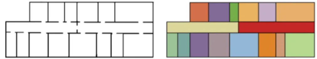
2.1.1 Map representation
A first problem to be solved while designing a comprehensive solution for autonomous navigation and mapping is the choice of the map representation. A typical choice is to use occupancy grid maps, where the environment is modelled as a two-dimensional matrix where each cell stores the probability of its corresponding region of the environment being occupied by an obsta-cle. Examples of grid-based approaches can be found in [15], [16], and [17]. One way to store and visualize occupancy grid maps is to normalize the probability values of the cells to the range of natural numbers between 0 and 255 and thus employ a 8-bit grayscale representation. Figure 2.1a il-lustrates this approach when the state of each cell is known with certainty, while Figure 2.1b shows the usage of gray shades to denote areas for which no occupancy information is available.
Another approach that is often used for its memory efficiency is line-based mapping. In this case, the map uses line segments anchored to an absolute two-dimensional metric frame to represent obstacles, while free areas are not explicitly stored. Figure 2.1c shows an example of this approach. Some works using line segments for mapping purposes are [18], [19], [20], [21], and [22].
Both occupancy grid maps and line-based maps belong to the family of metric maps, as they place objects in a 2D or 3D space. On the contrary, topological maps only consider places and relations between them, building a graph whose nodes represent places and arcs represent paths. An example of this approach is shown in Figure 2.1d, in which each node is associated to a room and arcs represent the possibility to directly move from a room to another, for example by means of a door connecting the two. These maps
(a) A binary occupancy grid map (b) A grayscale occupancy grid map
(c) A line-segments map (d) A topological map
Figure 2.1: The same floor plan represented with four different types of maps.
often, but not necessarily, also store the relative distances between places. Topological maps have been used, either alone or in combination with metric maps, in several works, including [23], [24], [25], and [26].
2.1.2 Exploration strategy
Besides the choice of an appropriate map representation, another significant problem is the selection of the exploration strategy. Although a robot could roam the environment in a completely random fashion and still eventually collect enough data to build a complete map, real-world applications require a much higher level of efficiency.
One possible option that has traditionally been employed in mobile robotics is to have the robot being remotely controlled by a human op-erator. However, this approach severely limits the ability of the robot to act on its own and is therefore of limited interest towards the achievement of higher levels of robot autonomy.
Early proposals to overcome this problem include [27], in which Mataric introduced the idea of wall-following exploration, and [23], where Thrun et al. discussed a greedy approach in which the robot uses value iteration to always move on a minimum-cost path to the nearest unexplored grid
cell. However, both these approaches have very limited applicability, as they require all walls to intersect at right angles and be clearly visible to the robot.
To overcome these shortcomings, Yamauchi [28] proposed a frontier-based exploration paradigm, in which the robot tries to maximize the amount of useful gathered information by moving towards one of several available frontiers, i.e., regions on the boundary between free known space and un-explored space. Figure 2.2 illustrates this concept by highlighting frontiers in blue. This approach has essentially become a de-facto standard since its introduction, both in single agent and multiple agents scenarios [29,30]. How-ever, the order in which frontiers are explored has a significant impact on the time required to build a complete map of the environment. Several fron-tier selection approaches have been proposed, from very simple exploration strategies like nearest frontier [28], farthest frontier, and nearest frontier cluster, to more complex ones, as in [31], [32], [33] and [34]. Work has also been done to quantitatively compare the performance of these approaches, as in [35], [36] and [37].
Figure 2.2: A snapshot of the occupancy grid map of an indoor environment during exploration. Frontiers are highlighted in blue in the rightmost image.
2.1.3 Sensors selection
Finally, a fundamental aspect in the development of SLAM algorithms is the selection of available sensors. Much like the various human senses cover different aspects of reality, the sensors of a robot determine which facets of the environment it is able to perceive and use for localization and mapping. Ultrasound proximity sensors, or sonars, are typically insufficient to per-form reliable localization, although there have been attempts to do so [38,39], and are most frequently used in conjunction with other sensors [40] or to perform collision avoidance. Odometry measurements, either coming from rotary informations on wheeled robots or obtained through an Inertial
Mea-surement Unit (IMU) [41], are also used to keep track of the amount of distance and rotation travelled by the robot.
Laser range scanners represent a much more complete source of infor-mation, as they can operate on distances that range from few millimeters to several meters, are able to work in the darkness, and have a significantly higher accuracy than sonars. In fact, they are a typical choice for high per-formance applications, and several algorithms [42–45] have been designed to take advantage of their capabilities.
Many approaches to perform localization and mapping using visual in-formation, known as Visual SLAM, have also been proposed. In this case, the information may come from plain monochrome [46, 47] or RGB [48] cameras, or from RGB-D cameras that are also able to capture information about depth [49, 50].
The integration of multiple sensors to perform the same task is called sensor fusion and can substantially enhance the performance of SLAM al-gorithms by compensating for the limitations of each sensor type. However, the choice of the sensors is often dictated by requirements about cost, space, or power consumption, thus practically limiting the amount and diversity of sensory information that can be exploited.
2.2
SLAM algorithms
With SLAM being such a significant problem to solve towards achieving higher levels of robot autonomy, a lot of research has been done on developing efficient solutions.
In 2003, Thrun [51] conducted a survey of the main 2D SLAM techniques available at the time, without focusing on any particular implementation; a similar approach was adopted in 2009 by K¨ummerle et al. [11], who clas-sified several 2D SLAM methods according to their underlying estimation techniques. On a more practical note, a 2007 study by Balaguer et al. [2] identified three popular SLAM algorithms for laser-equipped robots. In 2013, Santos et al. [3] surveyed four additional laser-based SLAM techniques avail-able as packages for the Robot Operating System (ROS) middleware. Similar surveys continue to be conducted [4] in order to keep track of the latest ad-vancements on SLAM techniques.
Here, we present an overview of the most significant SLAM approaches that have been proposed over the years, as well as some of the most widely used implementations. This section is by no means a complete survey of the available techniques, but is intended to give a general perspective on the
methodologies that have been explored and that continue to be developed by the research community.
2.2.1 Extended Kalman Filters
Extended Kalman Filters (EKFs) were among the first solutions to be pro-posed to perform simultaneous localization and mapping [52–54], but are still actively explored and improved by the research community [55,56]. The idea of EKF-SLAM algorithms is to exploit landmarks, i.e., predefined items that can be perceived by the robot sensors, to identify recurrent locations in the environment. The type of landmarks to be used is strictly dependent on the kind of sensors the robot is equipped with. A landmark may be identified through collisions, proximity detection, computer vision techniques or other means; for instance, Leonard et al. [57] proposed a method that uses sonar information to detect the presence of geometric beacons in the environment. In EKF-based SLAM, the map does not directly represent a 2D depiction of the environment, as with the case of occupancy grid maps; instead, it is a Gaussian variable that links the current estimate of the robot pose to the estimated pose of every other landmark in the environment.
As with plain Kalman Filters, there are two steps that contribute to the estimation of the robot’s pose: the prediction step, which is performed when-ever the robot moves and reflects the expected effect of the motor control process on the robot pose, and the correction step, which is triggered by the robot observations of the landmarks. This process can be seen as an appli-cation of the Bayes formula, in which the Kalman prediction represents the prior and is combined with the information obtained by the sensory obser-vations to produce a more accurate estimation of the robot’s pose. A similar principle is also used to continuously update the map of the environment.
An example of an algorithm that relies on EKFs is MonoSLAM1,2 [48], which uses a standard monocular camera to perform real-time 3D localiza-tion and mapping.
The main limitation of EKFs for SLAM applications is their computa-tional complexity, which is quadratic in the number of features, or land-marks, in the environment. This effectively reduces the applicability of full EKFs solutions to small and relatively feature-poor environments, and hin-ders their scalability to more complex and realistic scenarios. To overcome this limitation, Neira et al. [56] proposed an EKF implementation based on divide-and-conquer that has a reduced computational complexity of O(n).
1https://openslam.org/ekfmonoslam.html 2https://github.com/rrg-polito/mono-slam
Independently, Thrun et al. [58] and Eustice et al. [59] investigated the pos-sibility to introduce approximations to enforce sparsity in the information form of EKFs, also known as Extended Information Filters (EIFs), to en-hance their performance.
2.2.2 Particle Filters
Similarly to EKFs, Particle Filters (PF) are an application of Bayes filters. A particle filter is a non-parametric and recursive Bayes filter in which the posterior probability is directly represented by a set of weighted samples known as particles. Each particle is an hypothesis about the state of the en-vironment, which may comprise an estimate of the robot pose, a candidate map of the environment seen so far, or both. The fundamental assump-tion behind PFs is that the next state of the environment depends only on the current one, i.e., the estimation process is Markovian [60]. Among the many advantages of PFs over traditional EKFs, their ability to represent un-certainty through multimodal distributions and to deal with non-Gaussian noise are particularly important ones.
Some of the most relevant algorithms that are based on this kind of approach are FastSLAM, TinySLAM, DP-SLAM, and GMapping.
FastSLAM [61] uses a peculiar combination of PFs and EKFs to obtain better performance than plain EKF-based algorithms. While at its core it is built around a Kalman filter that tracks the position of a fixed number of predetermined landmarks, it also uses a particle filter to estimate the path posterior and update the estimated robot pose. The particle filter is subject to Rao-Blackwellization, a factorization technique that breaks the problem of jointly estimating the robot pose and the map in two separate problems; as the map strongly depends on the estimated pose of the robot, this marginalization process makes the estimation considerably more effi-cient. FastSLAM has been shown to work with over 50,000 landmarks at a time.
TinySLAM3,4 [43], also known as CoreSLAM5 in one of its
implemen-tations for the Robot Operating System (ROS) robotic middleware6, is a 200 lines of C-language code SLAM algorithm that was designed to be as simple and easy to understand as possible, while simultaneously maintain-ing an acceptable level of performance. In order to perform localization and
3
https://openslam.org/tinyslam.html
4http://wiki.ros.org/tiny_slam 5http://wiki.ros.org/coreslam 6http://www.ros.org/
mapping, TinySLAM requires both odometry information and obstacle dis-tance data provided by a laser range scanner. In TinySLAM, each particle is an hypothesis on the current pose of the robot in the environment and has an associated weight, which represents the likelihood of that hypothesis being true, that gets updated at every new laser observation according to a scan-to-map distance function; the best hypotheses are kept, the worst are eliminated, and new ones are generated. To keep complexity to a minimum, the algorithm maintains a single estimate of the environment’s map at any time.
Although still based on particle filters, DP-SLAM7 [62] implements a much more complex technique for SLAM estimation. From a sensory point of view, it requires the same data of TinySLAM, i.e., odometry and laser scans. However, instead of using particles to just represent hypotheses on the robot pose, DP-SLAM uses them to store both the estimated robot pose and a candidate map of the environment. It does so by using a peculiar data structure known as Distributed Particle (DP), which allows the algorithm to share common map parts across several particles, thus significantly reducing the memory footprint per particle and allowing for a much higher number of hypotheses at any given time.
Developed by Grisetti et al. [14,42], GMapping8,9also uses sensory
infor-mation from odometry and laser scans to perform localization and mapping. Differently from DP-SLAM, particles carry individual candidate maps of the environment, without sharing any data and with no explicit modelling of the robot pose. Similarly to FastSLAM, the particle filter is Rao-Blackwellized; however, GMapping also relies on two additional techniques to improve the overall mapping accuracy. First, the particles distribution is built by directly incorporating information from the latest laser observation into the model, instead of relying just on odometry data; this significantly reduces the esti-mation error, so that less particles are required to represent the posterior. Second, adaptive resampling is used to reduce the total number of parti-cles only when needed, thus keeping a greater variety of hypotheses and increasing the accuracy of the estimation.
2.2.3 Constrained optimization techniques
Finally, the SLAM problem has also been faced from the point of view of constrained optimization methods. The idea behind this family of techniques
7
https://users.cs.duke.edu/~parr/dpslam/
8https://www.openslam.org/GMapping.html 9http://wiki.ros.org/slam_GMapping
is that, at its core, SLAM is an optimization problem, whose goal is to find the most likely hypothesis for the environment’s map and the robot pose within it given the available sensor observations. Traditional maximum likelihood approaches are unapplicable to SLAM due to the high number of constraints that need to be taken into account; however, several techniques have been presented to overcome this issue by using approximations [38,63]. One of the most wildly used algorithms based on this approach is Hec-torSLAM10[45]. HectorSLAM is designed to work with laser range scanners, or LIDARs, and it supports 3D navigation using an inertial sensing system. As it does not rely on odometry, it is an ideal candidate for aerial appli-cations; however, this can be a drawback in applications where odometry information is available. The algorithm matches the scans obtained by the LIDAR sensor using a Gauss-Newton optimization method to solve a least square error minimization problem and find the rigid transformation that best fits the projected laser beams with the map. For aerial applications that need 3D state estimation, an EKF is also used.
Another method based on constrained optimization is LagoSLAM [64], a graph-based SLAM algorithm developed by Carlone et al. in which nodes represent the relative poses assumed by a mobile robot along a trajectory and edges denote the existence of a relative measurement between two poses. The algorithm attempts to estimate the set of absolute poses P in the refer-ence frame F that maximize the likelihood of the observations by minimizing a nonlinear, non-convex cost function through a series of local convex ap-proximations.
Finally, it is worth noting that progress in this field has not been confined to the academic research community, but has also seen active development within the robotic industry. An example of commercial graph-based SLAM algorithm is KartoSLAM11, a localization and mapping solution developed by Karto Robotics12.
2.3
SLAM performance evaluation
As the number of algorithms developed to solve the SLAM problem keeps growing, finding reliable ways to assess their performance has become a sig-nificant challenge for the robotics research community. This problem is in fact non trivial, as different SLAM algorithms applied to the same environ-ment may produce very different results, as shown in Figure 2.3. In addition,
10http://wiki.ros.org/hector_slam 11http://wiki.ros.org/slam_karto 12https://www.kartorobotics.com
different SLAM algorithms may use different map representations, making the comparison of their results difficult.
2.3.1 Evaluation scenarios
The first step in the development of reliable SLAM evaluation approaches is the identification of appropriate evaluation scenarios in which SLAM al-gorithms can be tested.
One approach that has been extensively investigated by the research community is to perform robotic competitions. In a robotic competition, a custom evaluation environment is created to either mimic a real application environment or to be particularly hard for a robot to handle. The robot is then assigned a task whose execution typically requires it to move from one point of the environment to another; the performance of the used SLAM algorithm is then indirectly evaluated by means of the overall performance of the robot at the given task. As the quality of the reconstructed map af-fects the ability of the robot to successfully complete the task, it is assumed that the systems that achieve the highest overall performance are also the best performing on the SLAM subtask. This approach has been used to evaluate, among others, the performance of cleaning robots [IROS, 2002], self-driving cars in an urban area [Darpa, 2007], rovers moving in a simu-lated Mars setting [ESA, 2008], and robots operating in Urban Search and Rescue scenarios [RoboCup Federation, 2009]. It has also been used for the evaluation of domestic service robots and industrial robots in the context of the RoCKIn project13of the European Robotic League14, as documented in [5], [65], and [66].
(a) HectorSLAM (b) GMapping (c) KartoSLAM (d) CoreSLAM (e) LagoSLAM
Figure 2.3: Occupancy grid maps of the same environment obtained by different SLAM algorithms through Stage simulations [3].
Two important shortcomings of robotic competitions are their limited scale and little resemblance to real application environments. This is due to
13http://rockinrobotchallenge.eu/
the complexity and cost of setting up a mock evaluation environment, which results in most competitions being held in relatively small settings that are poor proxies for the variety of environments that characterize real-world applications.
Another significant shortcoming of competitions is the significant com-plexity and diversity of hardware and software settings that have an impact on the robots’ performances. As each robot has a different hardware archi-tecture, software stack, and selection of navigation and mapping parameters, it is extremely difficult to say how much of a robot’s performance is due to the choice of the SLAM algorithm and how much is instead due to other factors. Moreover, the task is typically performed a limited number of times, or in some cases just once; as we will discuss in Section 3.2, however, the performance of a SLAM algorithm is not guaranteed to remain stable across multiple repetitions of the same task, so that an individual execution of the task may not be an accurate depiction of the actual average performance of the algorithm at that task.
These limitations, in addition to both hardware and software settings of the robots being tuned to the specific context of each competition, make it difficult to draw conclusions on the expected performance of a given SLAM algorithm in more realistic settings.
To overcome some of these problems, the robotics community has pro-posed to collect and publish collections of standard datasets for anyone to use as benchmarks. Evaluating SLAM algorithms on standardized sets of environments and robot settings is also a good experimental practice, as it ensures reproducibility, replicability, and comparability of the results sim-ilarly to what well-defined experimental methodologies guarantee in other branches of science.
Radish15,16 [6] is one of the oldest efforts in this direction. Proposed by Howard and Roy in 2003, it offers a collection of over 40 datasets of explorations conducted by real robots in many different, although mostly indoor, environments. The datasets typically consist of records of the sen-sory data collected during a run of a robot, an indication of which SLAM algorithm has been used, and a visual representation of the final map pro-duced. However, the datasets do not adhere to a common standard and have different levels of completeness. Most of them include laser scans and odom-etry data, while others include sonar data or monocular camera snapshots. The recorded data are sometimes offered in Carmen Log File (CLF) format, as it is commonly used in conjunction with ROS, but this is not always the
15http://radish.sourceforge.net
case. Some of the environments are explored by autonomous robots, whereas in others the robots are tele-operated. Almost none of the available datasets include ground truth data, neither of the followed trajectory nor of the floor plan of the building, preventing the evaluation of many performance metrics that are based on some form of a priori knowledge about the actual map and trajectory. Finally, although it is still currently widely used by the re-search community, the website has not been updated in over eight years, so it doesn’t reflect the state of the art of SLAM technology anymore.
Fontana et al. [1] conducted a similar, but more ambitious, effort in 2008 called the RAWSEEDS project17 [7]. It was proposed to overcome the limi-tations of Radish by performing multiple explorations of each environment, publishing recorded data in a defined and well-documented standard, si-multaneously collecting information from a variety of sensors, and offering ground truth data of both the robot trajectory and the building floor plan of each exploration. Unfortunately, it only collected very few datasets, and it hasn’t been updated since 2009.
Other publicly available datasets include runs performed at the KTH Royal Institute of Technology18 and at the MIT Killian Court location19, both of which were collected in the early 2000s. More recent efforts include dataset collections from the Computer Vision Group of the Technical Uni-versity of Munich20[67,68]. Additional resources can be found on the website of the OpenSLAM initiative21.
Having a real robot roaming a physical environment, either autonomously or in a tele-operated fashion, is also a major hurdle for the evaluation of SLAM algorithms because of the significant time and money that are neces-sary to perform the experiments. Moreover, it dramatically limits the scale and diversity of the tests that can be reasonably conducted to rather small environments, like specially fitted laboratory rooms, that fail to replicate the complexity of many real-world application environments. Simulation has been proposed as a possible solution to this problem, leading to the development of several robotic simulators.
The Player/Stage Project22 [8] is a suite of robotic tools developed by Howard et al. since 2003 to simplify the design, implementation and testing of robots. While Player provides a distributed, simple and clean control
17 http://www.rawseeds.org/home/ 18urlhttp://www.nada.kth.se/ johnf/kthdata/dataset.html 19 http://www.ijrr.org/contents/23_12/abstract/1113.html 20https://vision.in.tum.de/data/datasets 21http://openslam.org/ 22http://playerstage.sourceforge.net
interface for a robot’s sensors and actuators, Stage23,24 is a lightweight robot simulator that can handle populations of hundreds of virtual robots in a two-dimensional bitmapped environment. Stage supports a variety of actuators and sensors, including grippers, wifi modules, blinking lights, lasers, sonars and infrared ranger sensors. Simulated robots can be differential-steer drive models, omnidirectional models, or car-like; a simple odometry model allows to simulate the effects of a uniformly distributed random error on odometry readings. The suite can also be used in conjunction with ROS.
To overcome the limitations of two-dimensional simulations, Howard et al. introduced Gazebo25,26[69], an open-source robotic simulator that
recre-ates 3D dynamic multi-robot environments. It is built on top of the Open Dynamics Engine27 to accurately simulate the dynamics and kinematics of articulated rigid bodies. Compared to Stage, which simulates a purely 2D en-vironment, Gazebo enables more complex simulations that accurately mimic real-world physics and offer the possibility to simulate a broader range of actuators and sensors, which can also be extended via third party plugins.
USARSim28[70] is an alternative robotic simulator developed by Carpin et al. to support the virtual robots competition within the RoboCup initia-tive. Despite being originally conceived for Urban Search and Rescue ap-plications, it has evolved into a full-fledged, general purpose multi-robot simulator that can be extended to model arbitrary application scenarios. USARSim leverages Unreal Engine29, a commercially available game engine produced by Epic Games, Inc.30, to simulate 3D environments with high fidelity. Like Gazebo, it supports a wide range of actuators and sensors that can be extended via third party plugins.
2.3.2 Performance metrics
The second step in the development of reliable SLAM evaluation approaches is the definition of a suitable performance metric. To this regard, several approaches have been proposed over the years.
In [2], Balaguer et al. assess the performance of three SLAM algorithms -GMapping, GridSLAM, and DP-SLAM - by visually estimating the fidelity of the reconstructed maps of a set of indoor environments with respect to
23 https://github.com/rtv/Stage 24 http://wiki.ros.org/stage 25 http://gazebosim.org 26 http://wiki.ros.org/gazebo_ros_pkgs 27 http://www.ode.org 28https://sourceforge.net/p/usarsim/wiki/Home/ 29https://www.unrealengine.com 30https://www.epicgames.com
their ground truth counterparts, both in real world and in simulation with USARSim. However, the study lacks rigour and replicability, as the chosen performance metric is inherently subjective.
In [13], Amigoni et al. propose a methodology to address these shortcom-ings. According to this study, in order to effectively evaluate and compare different SLAM algorithms it is necessary to: i) provide extensive information about the produced maps, ii) report the behavior of the mapping system for different values of the parameters, iii) include one or more examples of maps produced following a closed loop path, and iv) whenever a ground truth map is available, use it to assess the quality of the estimation by evaluating its distance from the produced map according to a well-defined similarity metric. Furthermore, the datasets used to perform the evaluation must be publicly available, in order to let other researchers replicate the results.
In [9], Colleens et al. argue that comparing the map produced by a SLAM algorithm to its ground truth counterpart is not an appropriate evaluation metric. In fact, they claim that the main purpose of SLAM algorithms is not to produce human-understandable maps, but rather to create an appropriate representation of the robot’s surroundings to enable the execution of some other task, like navigation. In this context, the degree of accuracy of a pro-duced map with respect to a known ground truth does not necessarily reflect its usefulness, as schematic representations of the environment could still be sufficient for the completion of the desired task while more visually faithful representations could lack details, like doors and passages, that are crucial for the successful completion of the task. For this reason, they propose to use two different metrics: the first is the degree to which the paths created in the generated map would cause the robot to collide with a structural obstacle in the real world, and are therefore invalid; the second is the degree to which the robot should be able to plan a path from one pose to another using the generated map, but cannot because such paths are invalid in the ideal map. However, this approach also suffers from two main limitations, as it can only be applied to SLAM algorithms that produce occupancy grid maps as outputs and it requires precise alignment of the produced map with the ground truth map in order to verify whether paths identified in one of the two maps are also viable in the other.
In [7] and [10], Fontana et al. propose the adoption of several methodolo-gies for SLAM algorithms evaluation depending on the context of applica-tion. Expanding on the idea described by Colleens et al. in [9], they propose to adopt performance metrics that capture the ability of SLAM algorithms to produce useful maps in the contexts of localization and navigation. Their main contribution in this respect is the introduction of a Self-Localization
Error metric, computed by processing the distance errors between the esti-mated pose of the robot and the corresponding pose from the ground truth trajectory, and an Integral Trajectory Error metric, which is similar to the self-localization error but focuses on the overall distance between the recon-structed and ground truth trajectories over the whole path of the robot. It must be noted that both these metrics require ground truth trajectory information; Ceriani et al. address this problem in [1], in which they present two methodologies for collecting ground truth data for indoor localization and mapping based, respectively, on a network of fixed cameras and on a network of fixed laser scanners.
A significant drawback of metrics that rely on absolute poses is that they are strongly influenced by the timestamp at which an error occurs. This introduces a strong bias in the evaluation, as the same error may lead to very different results depending on whether it is introduced at the beginning, in the middle, or at the end of an exploration. Consider for instance a rotation error of a few degrees: if the error is introduced at the end of an exploration, its effect will be limited to a very small number of poses and its impact on the overall performance will be negligible; if however it occurs at the beginning of the exploration, the reconstructed trajectory will rapidly diverge from the ground truth one, leading to a much higher measured error despite the map still being substantially correct.
To overcome this limitation, Kuemmerle et al. in [11] and in [71] propose a metric that considers the deformation energy that is needed to transfer the estimated trajectory onto the ground truth trajectory, i.e., that is based on the relative displacements between poses. However, Kuemmerle et al. do not provide a definite criterion to choose which relative displacements should be considered to compute the metric, noting that, in absence of ground truth information, close-to-true relative displacements can be obtained by other sources of information, such as background human knowledge about the length of a corridor or the shape of a room.
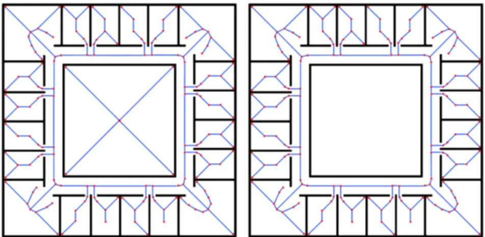
In the context of SLAM evaluation through map evaluation, Birk et al. investigate in [12] and in [72] the possibility to use topology graphs derived from Voronoi diagrams to capture high-level spatial structures of indoor environments. A Voronoi diagram is a partition of the space into cells; each cell encloses a site, i.e., a point on the map that represents an obstacle, and contains all points of the map whose distance to the site is not greater than their distance to all other sites. The graph is then obtained by considering the boundaries of said cells and applying a number of post-processing steps. Figure 2.4 shows a examples of filtered topology graphs.
Figure 2.4: Topology graphs of two sample maps.
- HectorSLAM, GMapping, KartoSLAM, CoreSLAM and LagoSLAM - in terms of distance between the generated map and the ground truth map using a performance metric based on the k-nearest neighbor concept.
Finally, Krinkin et al. [73] propose to evaluate the quality of generated maps by measuring three different aspects: the proportion of occupied and free cells to determine blur, the amount of corners in the map, and the amount of enclosed areas.
2.4
Performance generalization and prediction
As documented in the previous section, the research community has not agreed on a single method for SLAM algorithms evaluation, proposing in-stead several metrics to measure different aspects of their performance. However, a common trait of all these solutions is that they are designed to conduct evaluations on already collected data, i.e., they can assess the performance of a SLAM algorithm in a certain environment only after the environment has already been explored. This is a significant limitation for three reasons.The first is that ex post evaluations are typically rather difficult to per-form, especially in large environments. This is due to the need of gathering both sensory information and ground truth data in order to assess how much the SLAM algorithm’s results differ from reality in term of quality of map reconstruction and trajectory estimation. While reference floor plans and blueprints can usually be obtained with ease, the same doesn’t hold true for ground truth trajectory data, which requires extremely accurate tracking systems in order to be measured with adequate precision. An example of such a system is OptiTrack31, a positioning system developed by Natural-Point, Inc.32 in 2009 that uses a variable number of synchronized infrared
31https://www.optitrack.com 32https://www.naturalpoint.com
cameras, each containing a grayscale CMOS imager capturing up to 100 FPS, to triangulate the pose of an infrared reflector placed on the robot itself. As the environment becomes larger, the number of required cameras grows in the hundreds, making the system impossibly expensive and complex to operate.
Even when it is possible to have highly accurate ground truth data, ex post evaluations in real environments may be impractical to perform. All settings being equal, the performance of a SLAM algorithm in an environ-ment may in fact vary across multiple explorations, so that an individual exploration of the environment may not accurately represent the actual aver-age performance of the algorithm in that setting. A possible countermeasure is to repeat the measurements many times, which however turns the eval-uation procedure into a quite time-consuming process. We will discuss this issue more in depth in Section 3.2.
These two limitations can be overcome by taking advantage of computer simulations, which offer perfect pose tracking and can be often executed in parallel on dedicated servers to increase the throughput, while still provid-ing reasonably accurate results [2, 4]. However, there is a third fundamental limitation of these evaluation methods that affects both real-world and sim-ulated explorations: their lack of generalization capabilities.
Generalization is a fundamental aspect in all branches of science, as it provides the means to make predictions on the general behavior of a system in a wide range of situations starting from a much smaller set of observa-tions. In our context, by generalization we mean the process of identifying significant correlations between the performance of a given SLAM algorithm in a setting and its performance in a different setting. A setting is defined by the environment in which the algorithm is tested, the accuracy and the capabilities of the robot sensors, and the specific values of the algorithm parameters. Each of the examined evaluation methods proposes a different and potentially equally valid way to assess the a posteriori performance of a SLAM algorithm after an exploration has taken place; however, none of them provides a way to use previously collected performance data to make predictions about the performance of a SLAM algorithm in a setting before actually exploring the environment.
This limitation is significant, since knowing how well a SLAM algorithm performs in a certain setting does not immediately provide any information as to how well it will perform in a different setting, as the measured level of performance is strictly dependent on the characteristics of the setting itself. The problem is exacerbated by the fact that there is no single best SLAM algorithm for every scenario. As an example, a study [4] conducted by
Tur-nage using the Hausdorff distance between the ground truth map and the reconstructed map as a metric to assess the relative level of performance of HectorSLAM, CoreSLAM, and GMapping on three different environments shows that, while HectorSLAM outperforms both CoreSLAM and GMap-ping in two environments out of three, CoreSLAM performs best in the remaining one, with HectorSLAM and GMapping performing the same.
However, the ability to perform a prior assessment is crucial towards en-abling more pervasive applications of mobile robotics, as it vastly simplifies the deployment of robots in real-world contexts. The absence of generaliza-tion in SLAM performance assessment increases the difficulty in knowing at design time which SLAM algorithm and robot configuration best fits a given application scenario, often requiring a cumbersome and expensive trial and error process.
Research has been done on the broader topic of promoting generalization in robotics. On one hand, there have been attempts to explicitly improve the generalization capabilities of algorithms for robotic applications. One such example is [74], in which Pinville et al. propose a supervised learning approach to improve the generalization capabilities of controllers in evolu-tionary robotics. On the other hand, researchers have focused on the problem of developing approaches to predict robotic performance in a wide variety of contexts.
In [75], the authors investigate the usage of neural networks, fuzzy sys-tems, genetic algorithms, and other soft computing techniques to predict the performance of several industrial machining processes.
Considering autonomous wheeled robots, in [76] and in [77] Young et al. propose a model to assess the traversal cost of a natural outdoor envi-ronment for an autonomous vehicle using A* planning. The model exploits information about the complexity of the environment itself, including the slope of the terrain and the presence of vegetation, to ultimately predict the average speed of the vehicle. In [78], Regier et al. introduce a method to estimate the traversal time of a path by using its length, its smoothness, and its obstacle clearance as features of a non-linear regressor. The model, which is trained by using Gazebo simulations of an omnidirectional robot in a variety of maps, is shown to significantly outperform predictions only based on path length. Dawson et al. highlight in [79] the limits of several performance prediction systems in estimating the average coverage time of an environment in multi-robot autonomous exploration, citing the difficulty for simulations to properly take into account the slowdowns introduced by inter-robot communications, physical interferences and network latency.
higher level of generalization of experimental results in autonomous robotics is the limited representativeness of the experimental settings. This is espe-cially true for physical experiments involving actual robots, which are often conducted in small and carefully tuned labs that are very poor proxies for the variety of environments that characterize real-world applications.
2.5
Summary
In this chapter, we discussed the state of the art in the field of autonomous exploration and mapping in mobile robotics. At first, we overviewed the main issues connected with the navigation, exploration, and mapping of environments by autonomous robots. Next, we surveyed the landscape of algorithms that have been proposed to solve the problem of Simultaneous Localization and Mapping (SLAM), focusing on the most successful ap-proaches and implementations. Next, we discussed the state of the art of performance evaluation for SLAM algorithms, reviewing several evaluation methodologies and performance metrics that have been proposed to this end. Finally, we examined how the limited applicability and the lack of general-ization capabilities of such evaluation methodologies seriously hinder their usefulness in assessing the performance of SLAM algorithms in real-world scenarios.
Chapter 3
Problem formulation
In this chapter, we present a formal definition of the problem that we address in this thesis. We start by analyzing the motivations of this research, we set the thesis goal, and we introduce the concept of predictive benchmarking. We then review some preliminary definitions and we provide a formal char-acterization of the learning problem that we aim to solve. Finally, we discuss the scope of our analysis and we list the assumptions underlying our work.
3.1
Motivations and goal
As we mentioned in the previous chapter, the state of the art of SLAM al-gorithms performance evaluation is focused on the ex post assessment of the results of robot runs in benchmark environments, either using simulation [2] or with the use of benchmark datasets [5–7]. This kind of retrospective analysis can be useful for several comparison and evaluation purposes, but results obtained with such methodology can be difficult to generalize to the task of estimating the expected level of performance of a SLAM algorithm in a yet to be tested setting, like a previously unseen environment, different operational specs and types of the robot sensors, or when alternative values of the parameters are chosen [4]. One of the consequences of this limita-tion is a difficulty in extending the results obtained in controlled settings to the prediction of the expected performance of a SLAM algorithm in an actual application environment, thus severely limiting the deployment of autonomous mobile robots in real world and daily usage scenarios.
Consider the development of a robot for patrolling buildings. In order to safely, efficiently, and autonomously navigate a building, the robot must be able to build an internal representation of its surroundings and to cor-rectly track its own pose as it roams the environment, hence it must run a
SLAM algorithm. However, every building has its own characteristics due to a combination of age, architectural style, purpose, number of hosted people, and many other aspects. A kindergarten in a small mountain community is likely to have a different shape, size, and internal structure from the office of a large corporation, as a university campus is considerably different from a factory, and a hospital from a home. Different applications have different budget constraints as well as different safety and accuracy requirements, im-posing restrictions on the sensors and the SLAM algorithm to be used. As the performance of a SLAM algorithm is strictly dependent on the charac-teristics of the environment in which it is run and on the capabilities of the sensors used to collect the data, the lack of generalization of state of the art SLAM evaluation techniques results in long and extensive phases of proto-typing and field testing for each specific application scenario in order to tune the robot configuration and achieve the required level of accuracy. Further-more, as these evaluations can only be done a posteriori, it may be difficult to get an accurate estimate of the cost associated with certain safety and accuracy requirements before building the robot and testing it in its final operational environment, as the same performance level may require signif-icantly different hardware depending on the context. This severely impacts the ability of potential customers to plan their investments and ultimately limits the adoption of autonomous mobile robots.
The goal of this thesis is to take a first step towards overcoming the limitations of state of the art SLAM evaluation techniques by developing a software tool that employs known features of unexplored environments to predict the performance of SLAM algorithms in those environments.
To this end, we introduce the concept of predictive benchmarking, a method that reuses the performance results obtained by SLAM algorithms in benchmark environments to predict their performance in new ones. Com-pared to other SLAM evaluation techniques [3, 9–12, 73], predictive bench-marking has the advantage of providing an estimate of the expected level of performance of a given SLAM algorithm in new environments without requiring their exploration.
While existing SLAM evaluation techniques handle every new environ-ment as a separate standalone problem, predictive benchmarking builds upon the knowledge gained with each new exploration to create a model of the relationship between an environment and its associated SLAM per-formance; this results in increasingly accurate predictions over new environ-ments as the number of explorations used for training increases.
This approach significantly simplifies the development and deployment of autonomous mobile robots by allowing designers and manufacturers to
evaluate at design time the suitability of a certain choice of SLAM algo-rithm, parameters values and sensors for a given scenario, eliminating the need for extensive field testing sessions and therefore reducing the cost and length of the development cycle. It may also be used as a basis to perform comparisons between SLAM algorithms at a lower cost and on a broader set of environments than what is possible with traditional SLAM evaluation techniques, and to estimate the SLAM performance of an already developed robot in a real world scenario in absence of accurate ground truth position-ing data.
3.2
Localization error performance metric
Before we proceed with the detailed discussion of our work, it is first neces-sary to introduce some preliminary definitions and concepts. In the following paragraphs, we present and motivate our choice for the metric to be used for the evaluation and the prediction of the performance of a SLAM algo-rithm, we review its formal definition for single robot runs, and we propose a generalization to multiple runs of a single environment.
3.2.1 Metric definition
The research community has developed a variety of metrics to assess the performance of SLAM algorithms. In the context of this thesis, we use the localization error performance metric proposed by K¨ummerle et al. in [11]. This metric measures the performance of a SLAM algorithm as a function of its ability to accurately estimate the trajectory followed by a robot in a single run. To do so, the metric computes the deformation energy that is required to transfer the estimated trajectory onto the ground truth trajectory: the smaller the energy, the higher the accuracy of the reconstruction.
The choice of K¨ummerle’s metric was dictated by its generality and versatility. Compared to other evaluation strategies, such as those based on the comparison of different maps of the same environment, K¨ummerle’s approach is not restricted to any particular map representation format and can thus be used to measure the performance of any SLAM algorithm; it is also independent of the type of sensors mounted on the robot, and is therefore applicable to a broad range of scenarios.
We hereby recall the formal definition of the metric as given by K¨ummerle et al. in [11]:
Definition 3.1. Let x1:T be the poses of the robot estimated by a SLAM
algorithm from time step 1 to T during an exploration of environment E, xt∈ SE(2), with SE(2) being the usual special Euclidean group of order 2.
Let x∗1:T be the associated ground truth poses of the robot during mapping. Let δi,j = xj xi be the relative transformation that moves the pose xi onto
xj, and let δi,j∗ be the transformation based on x∗i and x∗j accordingly.
Finally, let δ be a set of N pairs of relative transformations over the entire exploration, δ =
n
hδi,j, δ∗i,ji
o .
The localization error performance metric is defined as: ε(δ) = 1 N X i,j (ε(δi,j))2 = = 1 N X i,j (δi,j δ∗i,j)2 = = 1 N X i,j
[trans(δi,j δi,j∗ )2+ rot(δi,j δi,j∗ )2] = (3.1)
= εt(δ) + εr(δ),
where the sums are over the elements of δ, is the inverse of the standard motion composition operator, and trans(·) and rot(·) are used to separate the translational and rotational components of the error.
3.2.2 Metric extension
As it stands, this metric is already sufficient to evaluate the performance of a SLAM algorithm in a single robot run. However, the performance of a SLAM algorithm in a certain environment may vary across multiple runs, so that computing this metric over a single run is only a rough indicator of the expected level of performance of the algorithm during the normal operation of the robot. These oscillations may be due to multiple factors, including noisy measurements, variations in the followed trajectory, and even a certain level of randomness that is inherent to the behavior of some SLAM algorithms.
For instance, consider the case of SLAM algorithms based on particle fil-ters, like FastSLAM and GMapping. These algorithms maintain a predefined number of hypotheses about the state of the environment which are continu-ously updated and discarded according to the information provided by each new observation. The selection of which particles should be maintained at each update step is based on a maximum likelihood probabilistic approach, so that particles with low weights tend to be replaced as time progresses.