1
A
CCESSIBILITY
-
RELATED EFFECTS OF THE METRO
NETWORK ON HOUSING PRICES IN
M
ILAN
:
ECONOMETRIC EVIDENCE AND SUGGESTIONS
FOR VALUE CAPTURE FISCAL POLICIES
THESIS BY: EFREM ERRERA SUPERVISOR: UGO FRATESI
STUDENT ID: 874339 CO-SUPERVISOR: GIOVANNI PERUCCA
ACADEMIC YEAR: 2018-2019 ROBERTO CAMAGNI
SCHOOL OF ARCHITECTURE, URBAN PLANNING AND CONSTRUCTION ENGINEERING MASTER OF SCIENCE IN URBAN PLANNING AND POLICY DESIGN
THESIS BY: EFREM ERRERA STUDENT ID: 874339
ACADEMIC YEAR: 2018-2019
SUPERVISOR: UGO FRATESI CO-SUPERVISOR: GIOVANNI PERUCCA
2
A
BSTRACT(English version)
Urban environments are complex systems where multiple forces simultaneously interact, creating a balance that shapes the form of urban life. Some of these forces are very place-specific, but many of them can be found in most urban environments, offering the opportunity to be investigated with the broad aim of increasing the relative comprehension of urban life and improving the man-agement of the urban environment as a whole. It is the case of the relationship between public transport infrastructure and land values, which presents recurring patterns all throughout the world and a long tradition of investigation. The specific interest in this particular element of urban life emerges with the acknowledgement that the public sector, which is often the promoter of investments in transport infrastructure, is encountering increasing difficulties in financing public transit projects due to the high initial capital costs and the limited treasury. Drawing from this consideration, this work starts with a reflection upon the relationship between urban public transport infrastructure investments, focusing on metro networks, and the potential land value uplifts generated by such physical transformations. Consequently, through a literature review of the most relevant studies on both the elements at the origin of land rent formation and on the empirical testing of land rent theories in relationship with metro station accessibility, the existence of this relationship in many cities is witnessed. Though, empirical evidence is missing for what concerns the city of Milan. To provide an answer to this knowledge gap, this work offers evidence of the relationship between land values and transportation infrastructure in the city of Milan through the development of an empirical econometric study.
This research, hence, pursues multiple goals: first, to briefly reflect upon the relationship between public transit infrastructure investment and land values; second, to understand which fiscal solu-tions have already been developed and applied to try and solve the emerging limitasolu-tions in public transport infrastructure funding; third, and most importantly, to investigate the characteristics of the relationship between metro station accessibility and land values in the city of Milan; fourth, and lastly, to combine all these elements into a fiscal reassessment policy suggestion.
Keywords:
Accessibility; metropolitan railway; econometric analysis; hedonic price method; land value uplift; land value capture; land rent; public transport infrastructure; Euclidean distance analysis; network distance analysis.
3
A
BSTRACT(Italian version)
Gli ambienti urbani sono sistemi complessi dove forze diverse interagiscono simultaneamente, generando un equilibrio che dà forma alla vita urbana. Di queste pulsioni, alcune si verificano solo in determinati luoghi, mentre molte possono essere individuate nella maggior parte degli ambienti urbani, offrendo così la possibilità di essere studiate con il generico obiettivo di aumen-tare la comprensione e di migliorare la gestione dell’ambiente urbano. Questo è il caso della rela-zione tra le infrastrutture di trasporto pubblico e i valori fondiari, che propone modelli ricorrenti in tutto il mondo e una lunga tradizione di indagine. L'interesse specifico per questo particolare elemento della vita urbana emerge con il riconoscimento che il settore pubblico, che è spesso pro-motore di investimenti nelle infrastrutture di trasporto, sta incontrando crescenti difficoltà nel finanziare progetti di trasporto pubblico a causa degli elevati costi iniziali di capitale e della sua limitata capacità di cassa. A partire da questa considerazione, la tesi inizia con una riflessione sul rapporto tra gli investimenti nelle infrastrutture urbane di trasporto pubblico, concentrandosi sulla metropolitana, e il potenziale aumento di valore del suolo indotto da tali trasformazioni fi-siche. Di conseguenza, attraverso una revisione degli studi più rilevanti sia riguardo gli elementi all'origine della formazione della rendita fondiaria, sia riguardo le dimostrazioni empiriche delle teorie sulla rendita fondiaria in relazione all’accessibilità alla metropolitana, si testimonia l'esi-stenza di questo rapporto in molte città. Tuttavia, mancano prove empiriche per quanto concerne la città di Milano. Per dare una risposta a questo vuoto di conoscenza, questo lavoro si offre come dimostrazione empirica del rapporto tra l’accessibilità alla metropolitana e i valori fondiari nella città di Milano attraverso lo sviluppo di uno studio econometrico. Questa ricerca, quindi, perse-gue molteplici obiettivi: in primo luogo, riflettere brevemente sul rapporto tra gli investimenti nelle infrastrutture di trasporto pubblico e i valori fondiari; in secondo luogo, capire quali solu-zioni fiscali siano già state sviluppate e applicate per cercare di risolvere i limiti legati al finanzia-mento delle infrastrutture di trasporto pubblico; terzo, e di maggior rilievo, indagare le caratteri-stiche del rapporto tra accessibilità alla metropolitana e valori fondiari nella città di Milano; per finire, combinare questi elementi in dei suggerimenti di riforma fiscale.
Parole chiave:
Accessibilità; metropolitana; analisi econometrica; modello di prezzi edonici; aumento del valore fondiario; cattura del plusvalore fondiario; rendita fondiaria; infrastruttura di trasporto pubblico; distanza euclidea; distanza di rete.
4
A
CKNOWLEDGMENTSI would first like to thank professor Roberto Camagni for his passion and dedication, as well as Ugo Fratesi and Giovanni Perucca for the technical knowledge they shared and the help they pro-vided. Secondarily, I would like to thank professor Emmanuel Matsaganis and professor Paolo Beria, who helped me take the right path and find the right supervisor when ideas were only at their embryonic stage, and professor Marzia Morena for the provision of the data. I would also like to express my gratitude to professor Patxi J. Lamíquiz Daudén and researcher Jose Carpio-Pinedo from the Departamento de Urbanística y Ordenación del Territorio, Universidad Politéc-nica de Madrid: it was during their lectures in my Erasmus+ period in Madrid that I came across the issue of infrastructure provision-related land value uplifts. Last but not least, special thanks go to my family, friends and Ginevra, for their unconditioned and loving support.
5
T
ABLE OF CONTENTSABSTRACT ... 2
PREFACE ... 8
ABBREVIATIONS ... 12
CHAPTER 1 | TRANSPORTATION AND PROPERTY VALUE CREATION ... 13
1.1 The relationship between transport systems and land values: accessibility ... 14
1.2 Econometric analysis technique: the hedonic price method ... 21
1.3 The effects of proximity to transit stations on neighbouring land values: empirical evidence from the literature ... 24
CHAPTER 2 | THE FUNDING OF PUBLIC TRANSPORT INFRASTRUCTURES AND THE UNEVEN DISTRIBUTION OF GENERATED BENEFITS ... 28
2.1 The rationale for Land Value Capture ... 30
2.2 The different levels of Land Value Capture fiscal policies ... 35
2.3 Land Value Capture, tools and experiences ... 41
CHAPTER 3 | THE CASE STUDY ... 56
3.1 Milano and its transit system ... 56
3.2 The residential market in Milano ... 61
CHAPTER 4 | DATA AND METHODOLOGY ... 65
4.1 Finding a dataset ... 65
4.2 Measuring accessibility: fixed-distance buffer vs street network distance ... 69
4.3 Description of the data ... 79
4.4 Model estimation ... 84
CHAPTER 5 | RESULTS OF THE RESEARCH ... 85
5.1 Hypothesis testing n.1: the relationship between real estate values and distance to the metro... 85
5.2 Hypothesis testing n.2: the anticipated capitalization effects ... 94
CHAPTER 6 | FINDINGS AND CONCLUSIONS ... 99
6.1 Findings ... 99
6.2 Policy recommendations ... 102
6.3 Conclusion and future directions ... 103
6
L
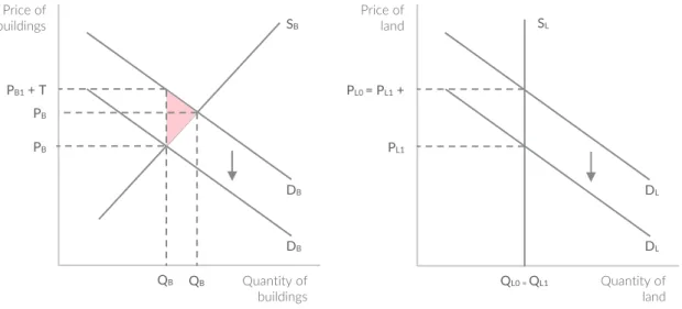
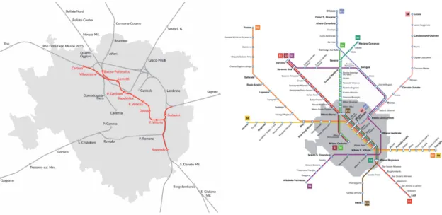
IST OF FIGURESFigure 1. Residential accessibility benefits from transit investment in the monocentric city. Source: Murakami (2012) ... 16 Figure 2. Feedbacks in systems of transportation and land use. Source: Levinson (1997). ... 18 Figure 3. Positive and Negative LVU Effects by Distance Specification. Source: Higgins & Kanaroglou (2016). ... 21 Figure 4. Land Value Uplift coefficients from study sample. Adapted from Higgins & Kanaroglou (2016). ... 25 Figure 5. Total Land Value components and structure of the capitalized land value. Source: Medda (2012) ... 31 Figure 6. The virtuous circle of urban growth. Source: Camagni (2016) ... 35 Figure 7. Types of direct value capture. Adapted from Alterman (2012) ... 38 Figure 8. Effects of the tax on improvements and of the tax on land. With a tax on buildings, demand decreases, causing price and then supply to decrease. On the contrary, the supply of land is perfectly inelastic and remains constant: if land is taxed, demand decreases, causing lower prices. Source: King & Nesbit (2007) ... 46 Figure 9. Representation of the “passante ferroviario”, in red on the left, inside the railway system. Source: Wikimedia Commons ... 57 Figure 10. The existing metro and suburban railways network. Source: ATM ... 58 Figure 11. Scheme of the upcoming M4 blue line. Source: ATM. ... 59 Figure 12. Scheme of the Metropolitana di Milano in its 2023 future complete layout. Produced by the author. ... 60 Figure 13. Residential market fluctuations in Milan between 2007 and 2017. Produced by the author using Tecnocasa data. ... 61 Figure 14. Real estate market homogeneous areas. Produced by the author on data from Agenzia delle Entrate, Osservatorio del Mercato Immobiliare ... 63 Figure 15. Distribution of the observations across the municipality of Milan. Produced by the author on data from Agenzia delle Entrate, Osser-vatorio del Mercato Immobiliare ... 68 Figure 16. Extract of the plan “Accessibilità alle reti di trasporto” (accessibility to transport network) from the Piano dei Servizi (service plan) of the decayed Piano di Governo del Territorio of the Municipality of Milan, with a highlight on the representation of the accessibility to the public transport network of the city: “areas with high accessibility to public transport network”. Source: Piano di Governo del Territorio 2012, Comune di Milano ... 69 Figure 17. Extract of the plan “R02 Indicazioni Urbanistiche” (planning indications) from the Piano delle Regole (rule plan) of the Piano di Governo del Territorio in force of the Municipality of Milan. The blue line incorporates “areas with high accessibility to public transport network”. Source: MILANO 2030 - Piano di Governo del Territorio (2019), Comune di Milano ... 70 Figure 18. Overlook of the complete plan “R02 Indicazioni Urbanistiche” (planning indications) from the Piano delle Regole (rule plan) of the Piano di Governo del Territorio in force of the Municipality of Milan. The blue line incorporates “areas with high accessibility to public transport network”. Source: MILANO 2030 - Piano di Governo del Territorio (2019), Comune di Milano ... 72
7
Figure 19. The influence of different factors (urban network patterns, barriers and closeness between service areas) over miscalculations of coverage areas. Source: Gutiérrez & García-Palomares (2008) ... 73 Figure 20. An example of a batch computation of network distances, with a manual testing online. Produced by the author ... 76 Figure 21. Correspondence between distance measure techniques. Produced by the author ... 77 Figure 22. Underestimation of the actual walking distance occurring when the linear method is used to compute the distance between each of the 4976 observations of the study and their nearest metro station. Produced by the author ... 78 Figure 23. An example of the different results provided by the two alternative methods. Produced by the author ... 78 Figure 24. Distribution of observations: Price/sqm vs. Ln(Price/sqm). Produced by the author .... 79 Figure 25. Distribution of observations: Distance from closest metro vs. Ln(Distance from closest metro). Produced by the author ... 91 Figure 26. Comparison of the 5 Models developed thus far. Produced by the author ... 92 Figure 27. Land Value Uplift in Milan compared to that of other cities. Adapted from Higgins & Kanaroglou (2016). ... 93
L
IST OF TABLESTable 1. Land value capture instruments by beneficiaries. Source: Iacono et al. (2009) ... 43 Table 2. Summary statistics. Produced by the author ... 80 Table 3. Model 0 and Model 1. Produced by the author ... 87 Table 4. Alternative regression models to better describe the effect of proximity to metro stations on housing prices. Produced by the author ... 90 Table 5. Timeline of the metro lines during the time span of the real estate observations. Produced by the author ... 94 Table 6. Regression models to test the anticipated capitalization effect for each of the lines interested by an extension. Produced by the author ... 96 Table 7. Timeline of the Metropolitana di Milano. Produced by the author ... 113
8
P
REFACEIn an era where global population is progressively settling in cities, and cities are gradually evolv-ing into metropolitan cities, megacities and megalopolis, urban systems of mass transportation are more and more needed to allow fast, safe and efficient commuting, and to reduce the negative externalities occurring when motorized private transportation is preferred (most importantly: traffic congestion, which leads to slower speeds, longer trip times, and increased vehicular queue-ing; air pollution; noise pollution). Yet, the diminishing financial power of public institutions – the usual promoters of such costly public transit investments – limits the opportunities for cities to evolve accordingly to their needs. A potential help to increase public revenues – that could then be directed to the aforementioned investments – is to structure and apply a fiscal reform which would target the increased land value benefits that originate from the increased accessibility en-sured by the development of the infrastructure itself.
Prior to the proposal of a fiscal policy shift, a crucial and instrumental step is needed to verify if the preconditions apply: the econometric assessment of the relationship between accessibility to urban public transport infrastructure and land value uplifts.
Being the metropolitan city of Milan Italy’s best example for the potential development of a fiscal policy reform, this research wants to empirically assess the relationship between land values and accessibility to Milan’s metropolitan underground system.
Inclusively, the research is structured as following:
• The first chapter outlines the general theories on land rent formation – which constitute the base of any research in the field of applied urban economy – and the most prominent literature on the methodology used for their assessment;
• The second chapter presents a brief but important analysis of the alternative financing sources of urban transit infrastructures that go under the umbrella of Land Value Capture policies;
• The third chapter offers an analysis of the Milanese network system and real estate mar-ket, focusing on their recent history and geography;
9
• The fourth chapter outlines the research methodology and the dataset, with a further in-terest in comparing different accessibility measure techniques and selecting the less bi-ased option;
• The fifth chapter describes the results of the empirical econometric study on Milan; • Finally, the last chapter interprets the key findings of the research and, on their basis,
proposes general suggestions for a correct development of a fiscal reform.
R
ESEARCHQ
UESTIONSIn the broad topic of accessibility-related impacts on land values, the research tries to explain the relationships occurring between investments in public transport infrastructure and real estate market in Milan. The first two questions represent the core of the research, while the third and fourth questions act as a secondary line of investigation:
1. What is the relation between residential prices per square metre and distance to the metro stations in Milan?
2. Does real estate market capitalize the value generated by the Milanese metro network? 3. At what stage of the infrastructure construction is this value capitalized?
4. Would it be possible to capture a share of this unearned private earning to improve the financial availability of the local administration and fund further public expenditure in public transport systems?
R
ESEARCHO
BJECTIVESEvolving from the research questions, the research objectives are:
• To critically examine existing literature in the field of accessibility-related land rent stud-ies, both from a theoretical and from an empirical perspective;
• To outline and clarify the rationale behind land value capture policies and practices; • To present, through the lens of international study cases, the most prominent policy
10
• To test the difference between alternative distance measures: the traditionally applied Eu-clidean distance method and the more accurate network distance method;
• Lastly, but most importantly, to provide empirical evidence on the correlation between public transport infrastructure accessibility and house prices in Milan through the devel-opment of an hedonic regression model;
Despite the effort in encapsulating as many relevant aspects related to land value uplift and land value capture, this work must not be intended as an A to Z recipe to develop and apply a land value capture policy program in the city of Milan. The aim of this research, in fact, is not to pro-pose a fiscal reform “out of the books”, rather to combine theoretical knowledge drawn from the literature and empirical evidence emerging from the analysis of the case study, and forge them into a stepping stone for further investigations and implementation, when and if the political will-ingness and social acceptability would allow land value capture to be positively considered.
R
ESEARCHM
ETHODOLOGYThe research mainly addresses a practical issue. To tackle such issue with the necessary awareness, a dedicated theoretical study of the existing literature is first needed to fully understand theoretical and practical implications. Hence, the research follows an empirical and quantitative approach, drawing from both theoretical and empirical knowledge from the global literature of the same field, and empirical evidence from the case study of Milan. Furthermore, the ultimate goal of the research (and of the studies in the same line of research) is that of offering a justification for the proposal and potential implementation of a fiscal policy reform. From this, the secondary area of focus related to land value capture policies was investigated, to give a broad sense of the potential application of the results of the work. Specifically, the different areas of study investigated are:
• economic theory on land rent formation;
• econometric theory and evidence, and econometric practical and technical aspects for an independent set up;
• fiscal theory on land value capture policies;
• accessibility measures theory and their empirical evaluation;
11
R
ESEARCHL
IMITATIONSThe first and foremost limitation of the research is the limited availability of real estate market data. The search of a dataset that could answer the needs for a micro-level econometric analysis proved to be difficult, and the obtained dataset was not ideal for the purpose of the work. Never-theless, the utilized dataset is, to date, the best available solution.
Secondarily, the absence of a shared framework of analysis on transport network accessibility-related land value uplifts leaves most methodological choices in the hands of the author of the estimation, making it relatively hard to compare the results with other studies of the same kind, each of which developed in a methodologically different way.
R
ESEARCHC
ONTRIBUTIONSThe research offers empirical evidence on the relationship between metro stations accessibility and residential real estate values in the city of Milan, and is intended as a first empirical step in the direction of a – now – justifiable land value capture fiscal reform, able to help the public sector in finding resources to upkeep and further expand public infrastructure systems for the Milan of tomorrow.
12
A
BBREVIATIONSAPI Application Programming Interface
AR Air Rights
ATM Azienda Trasporti Milano CBD Central Business District
CSV Coma Separated Value (file type extension) DC District of Columbia
DIF Development Impact Fees DLT Development Land Tax
EXPO Exposition
FN Ferrovie Nord
FS Ferrovie dello Stato
GIS Geographic Information System GWR Geographically Weighted Regression HPM Hedonic Price Method
IMU Imposta Municipale Unica ISAP Athens-Piraeus Electric Railways
JD Joint Development
LAMTA Los Angeles Metropolitan Transit Authority
LVC Land Value Capture
LVT Land Value Tax
LVU Land Value Uplift
MTRC Metropolitan Transit Railway Corporation
NE Negotiated Exactions
OMI Osservatorio del Mercato Immobiliare - Agenzia delle Entrate OSMI Osservatorio del Mercato Immobiliare - Borsa Immobiliare Milano PGT Piano di Governo del Territorio
SAC Autocorrelation Model SAD Special Assessment District SAR Spatial Regression model
SCRTD Southern California Regional Transit District
SDM Durbin Model
SEM Spatial Error Model TIF Tax Increment Financing TOD Transit Oriented Design TUF Transportation Utility Fees
UN United Nations
13
C
HAPTER1
|
T
RANSPORTATION AND PROPERTY VALUE CREATIONThe structure of cities is shaped by various forces. Some, such as the location of initial settlements and of the city’s more affluent residents, are the results of ancient circumstances and can only be described. Others, like the interaction between transit networks and land markets, offer a long tradition of theoretical and empirical evidence, providing, to date, sufficient material for the aca-demic research which has been able to deliver a robust explanation for observed configurations of land value (and, consequently, development densities) in cities. This latter relationship, that of transport networks capable of influencing the patterns of urban land values in cities, is the focus of this research.
Cities are the core of the larger economies in which they are located. Their birth, evolution and existence are motivated by the possibilities enjoyed by their residents to take advantage of econo-mies of scale in production and various sources of agglomeration econoecono-mies, such as labour mar-ket pooling, input sharing and knowledge spillovers (Rosenthal & Strange, 2004). For these ele-ments to take place, a fundamental requisite is the relatively low transportation costs provided by a highly developed transportation network, a common element of most prosperous large cities. Being able to provide reliable transport networks is one of the most important challenges facing large metropolitan areas, as their provision is a great determinant for their competitiveness, qual-ity of life and poverty levels. When governments succeed to implement efficient transit solutions, economic growth generated by such investments – and by the consequent agglomeration econ-omy effects – drives boosts in urban land and property values.
Furthermore, most developed and developing cities are facing common issues brought about by population growth, such as traffic congestion, air pollution and sprawling development patterns. These problems are often related to the heavy reliance on the car as a primary transportation mode (Travisi, Camagni, & Nijkamp, 2010). To reduce this dependence and thereby mitigate the undesired direct and indirect side effects of population growth, for the provision of urban transit a range of alternative transport services must be considered. The ideal solution is often found in the construction or extension of urban and suburban transit systems, which are able to provide capacity and competitive levels of service for a large number of urban travellers.Pundits argue that, because rail transit is valued as a valid alternative to private transportation, it will reduce the
14
number of cars on the road and, as a secondary effect, encourage more compact patterns of growth by drawing real estate development closer to transport stations (Bowes & Ihlanfeldt, 2001). Fur-thermore, successful public transport systems result in a multiplicity of positive effects: by reduc-ing travel time, they ease access and increase location value in both station areas and throughout their entire service corridor. As a side effect, enhanced access fosters the agglomeration economies that make cities powerful economic engines (Blanco, Moreno, Vetter, & Vetter, 2016). When this strategy is well developed by the local planning authority, favouring this virtuous cycle, cities thrive.
1.1
T
HE RELATIONSHIP BETWEEN TRANSPORT SYSTEMS AND LAND VALUES:
ACCESSIBILITYObserved patterns of land use in cities are largely explained by the interaction of land markets and transportation networks. The mediating element that represents this interaction is the concept of accessibility. Accessibility can be loosely defined as the ease of reaching desired destinations (Iacono et al., 2009). A broader and more behaviourally-relevant definition of accessibility is the potential for reaching spatially distributed opportunities from a particular location while consid-ering the difficulty involved in travelling to them (Páez, Scott, & Morency, 2012). What exactly is meant by “desired destinations” or “opportunities” can vary depending on cultural environment and socioeconomical circumstances, but it generally involves a set of activities that households engage in on a fairly frequent basis. The most important of these activities is employment, which has been consistently identified as one of the most important (and hence, most studied) influences on the location decisions of households. Other types of activities that households might value access to include shopping destinations, entertainment venues, or educational institutions (espe-cially higher education institutions, which are more limited in supply). Locations with higher ac-cessibility tend to command higher prices for land, while locations with less acac-cessibility tend to be cheaper. As noted by Iacono et al. (2009), accessibility is a dynamic concept since transporta-tion networks are being continually modified over time, and that firms and households respond to these changes to transportation networks, and the accessibility they provide, by eventually changing their location. These location decisions and the patterns of accessibility they represent eventually become capitalized into land markets, giving rise again to a different set of location incentives.
15
Being generally true that the centres of major cities the places where a higher density of business, shopping and cultural activities are hosted, this is also why the closeness to the city centre is con-sidered as a certain quality characteristic, which gets valued and priced into real estate market. The quick yet superficial conclusion is that the closer a property is to the city centre, the higher its value should be: since the distance that a city centre inhabitant must cover to reach the desired destination is lower compared to that of somebody living further away, the inner city inhabitant can exploit and make use of the amount of time that he saved by not needing to travel. This saved time has a value, strictly related to the location of residence with respect to desired destinations, which gets capitalized in the value of land upon which lays the inner city inhabitant’s place of residence.
This assumption dates back to the studies of Von Thünen (Thünen, 1830) the German economist who studied the location of economic activities across space. According to his theory, accessibility to the marketplace is responsible for the difference in value between areas of farmland with similar fertility but different location. In later studies, Alonso and Muth refined this argument in a bid– rent analysis (Alonso, 1964; Muth, 1969), where they claim that the land rent that all firms are prepared to pay is the residual component of a function that includes price of production, entre-preneurial profit and quantity of product sold, and is highly reliant on transportation cost: land rent varies depending especially on the location of the land. Assuming the city to be monocentric, meaning that the vast majority of employment is located in the centre, this leads to a rent gradient that decreases as distance to the central business district (CBD) increases, for sites that have equal utility. In the analyses conducted thus far, the dominant factor explaining the difference between land (hence property) values was accessibility, as measured by the distance to the CBD and asso-ciated transport costs. However, the monocentric city model’s basic development occurred in the 1960’s and 1970’s. Since then cities have become increasingly polycentric, and the monocentric city model, with its assumption of a single concentration of employment, has been criticized on the grounds that the cities it explains are from a different era. More complex models and estima-tions have been developed in the meanwhile, but many of the studies in this field still utilizes distance to the CBD as a proxy for higher employment densities, assuming the rest of the city to be uniformly decreasing in employment opportunities. Following on these theories, scholars have drawn complementary conclusions on the existence of urban areas, characterized by increasing
16
returns to scale at the city level, which are referred to as urban agglomeration economies, com-prising localization economies and urbanization economies (Mills & Hamilton, 1994).
The essential theory on real estate market prices can therefore be defined as follows: as a location becomes more attractive due to certain characteristics, demand increases and thus the bidding process pushes prices up. In most cases, being CBDs the centres of the most attractive activities (particularly in radiocentric cities like Milan), proximity to the CBD is considered an important quality that increases property prices.
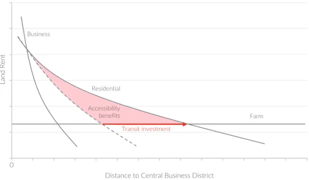
Yet, to some extent investments in transport infrastructure counterbalance this demand tension around the CBD by drawing households to settle around the transit stations instead (Fejarang, 1994): because urban transit infrastructure offers a decrease in generalized transportation costs for land around a station, properties located close to the transit stations take advantage of the transport time and cost savings. This accessibility benefit in turn should create a locational ad-vantage, cause people and firms to outbid one another for the land and result in a localized bid-rent surface that peaks at transit stations, increasing land values all around the newly constructed transit investment (Figure 1). The vast majority of studies in this field have operationalized acces-sibility indirectly through measures of proximity to rapid transit access points to capture this bid-rent surface as a proxy for underlying accessibility benefits (Higgins & Kanaroglou, 2016).
Figure 1. Residential accessibility benefits from transit investment in the monocentric city. Source: Murakami (2012) 0
Land Rent
Distance to Central Business District
Business
Residential
Accessibility
benefits Farm
17
The advantages triggered by the provision of efficient transport networks, like an intercity road or a rail transit system, are rather straight forward to imagine. A new connection might lower logistic costs of shipping goods by offering a more direct route, which in turn would reduce the labour and the energy inputs required to make a given trip. In an urban context, a new link might reduce travel costs for its users.
“Reducing transportation costs through incremental improvements to networks frees up resources that can then be put to other uses.”
(Mohring, 1961)
More broadly, transportation networks provide value by linking together places that people wish to access (Iacono et al., 2009). The value they provide is conventionally thought of as the time saving provided by the transportation improvement and internalized by the user, which then he can allocate to other uses, such as work or leisure1. This assumption has proven to be difficult to
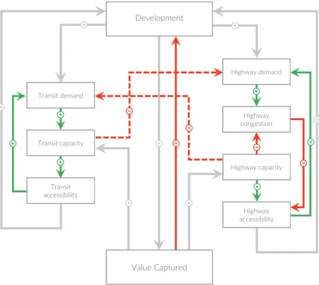
demonstrate in practice, with evidence that the amount of time spent traveling by households has remained remarkably constant over long periods of time (Mokhtarian, 2004; Zahavi & Talvitie, 1980). This indicates that other forms of behavioural patterns modifications might be taking place in response to transit improvements. Iacono et al. (2009) highlight how different alternative user responses can be drawn: households might be taking advantage of the additional time savings by increasing the number of activities they participate in, or they might move to a more desired lo-cation, or they might move to a location where land is cheaper and they can consume more hous-ing, all while maintaining the same commute length or duration. While these responses are less direct, they are nonetheless beneficial and suggest the existence of some type of transportation related benefit.The latter response suggests that patterns of land use and land value may provide clues as to how these benefits are realized. As noted by Levinson (1997), land use and transporta-tion systems – and their associated patterns of accessibility – are characterized by feedback loops which mutually affect all of the different elements of the systems (Figure 2). According to the author, increases in the capacity of the transportation systems in response to rising demand lead
1 Conventionally, the measure of user benefits for the evaluation of transportation improvements is a stand-ard value of time saving as a function of local wage rates. The underlying assumption, difficult to be proven, is that time savings brought about by transportation improvement would be allocated to additional work effort.
18
to increases in land value, while increases in congestion causes the opposite effect. That is because travel time acts as a disincentive to consumers to choose destinations that are further away, since consumers must expend resources to access those destinations. Increases in travel time or other travel costs reduces the number of destinations that can be feasibly accessed, given the budgets households are restricted to in terms of money or time. The feedback effects continue when the increases in land value caused by increases in accessibility lead to a larger amount of development, which again begets higher land values. In the long run, these positive and negative feedback effects tend to balance each other, with land prices playing a mediating role.
Figure 2. Feedbacks in systems of transportation and land use. Source: Levinson (1997).
To better understand the consumer’s utility maximisation point of view, it is possible to draw interesting conclusions following the simple capitalization model of Agostini & Palmucci (2008), based on Alonso (1964). This model targets the problem of each consumer in the housing market,
Development Highway demand Highway congestion Highway capacity Highway accessibility Transit demand Transit capacity Transit accessibility Value Captured
19
which consists in maximizing his/her own utility when choosing between different alternatives. The utility maximisation is based on the size and location of the housing unit and all other con-sumption goods, subject to a budget constraint that explicitly considers transportation costs and its effects on housing prices.
Briefly, the maximization looks as follow:
max U(s,d,o)
with a budget constraint:
Y = P(d)s + T(d) + o
Where Y is the consumer’s income, P(d) is the price per square meter of the property related to the distance to the closest station, d is the distance of the housing unit from the closest metro station, s stands for the size of the property in square meters, T(d) is a cost function of transport and o is a compound good made up of all the other essential attributes an individual values of a property. The reason why distance is included in an individual’s utility function is that of captur-ing the inconvenient necessity for the consumer to reach the nearest station, actcaptur-ing with a negative effect as distance increases, hence moving the ideal housing location. Let’s assume that our utility function U satisfies the following conditions: U is continuous, smooth with continuous derivatives of second order and strictly quasi-concave. Furthermore, U is increasing in s and o and decreasing in d. Additionally, ∂P(d)/∂d<0 and ∂T(d)/∂d>0. The first order conditions for this maximization problem are the following:
Us − λP(d) = 0
Ud − λ(Pdm + Td) = 0
Uo − λ = 0
Y − o −P(d)m − T(d) = 0
One of the equilibrium location conditions can be obtained from the first and third equations of the previous list:
𝑈
20
This first equilibrium condition establishes that the marginal ratio the consumer is willing to ac-cept to substitute consumption of square metres of property, s, with consumption of other goods is equal to the relative price. Relative prices depend on the distance, d, to the transport service under study.
A second equilibrium condition is obtained from the second and third equations of the same list:
𝑃 𝑚 = − 𝑇 − 𝑈 𝑈
This second condition establishes that the marginal willingness to pay per square metre of prop-erty to increase distance decreases as marginal transport costs increase and rise as marginal disu-tility rises. This simple model shows that, from a theoretical viewpoint, house prices should be negatively related to the distance to the nearest metro station: as distance to the nearest metro station increases, prices go down. The expected outcome is a price curve with a negative slope (Figure 3), where, as we move away from the station, prices decrease.
This price/distance relationship is not necessarily monotonically decreasing, since the metro sta-tion may potentially have counterbalancing impacts. On the one hand, the convenience of a new means of transport generates a direct positive effect by reducing transport costs for neighbour-hood residents; on the other hand, the metro station produces a multitude of indirect negative effects, such as increased circulation of people, a higher noise level, increased pollution levels and negative spillover due to redistribution of economic activities (R. Cervero & Duncan, 2002). The net impact of this host of indirect effects is ambiguous and place specific, because some of them may have a positive impact on the price of the housing units nearest to the station, contributing to the price increase, while others may have a negative effect, which potentially could flip the curve in the negative environment (Figure 3). As noted by Higgins & Kanaroglou (2016) in their com-prehensive and critical review of over 130 analyses across 60 studies completed in North America over the past 40 years, a significant heterogeneity is found in terms of research outcomes. Apart from illustrating that public transit networks investments do result in compact urbanisation and acknowledging that the final goal was to provide evidence for the implementation of value capture schemes for financing rail investment, their review confirms that many analyses have indeed found significant positive relationships between proximity and price. However, as with study methods, there is a dramatic range in findings, and several seemingly similar studies have drawn
21
opposite findings, with some coming to the conclusion that transit has actually decreased land values.
Figure 3. Positive and Negative LVU Effects by Distance Specification. Source: Higgins & Kanaroglou (2016).
Following this reasoning line, and since every transport network and city present peculiar char-acteristics and differences both within the system (station hierarchies, neighbourhoods’ socio-economical characteristics, local scale environmental characteristics, crime density) and in com-parison with other cities, an empirical analysis of the desired network is necessary to verify and test which of the assumptions holds, and if the same curve is persistent throughout the whole network or if it changes according to the inner differences highlighted above. To date, no con-sistent relationship between proximity to underground stations and property values has been studied and reported for the city of Milan.
1.2
E
CONOMETRIC ANALYSIS TECHNIQUE:
THE HEDONIC PRICE METHODThis kind of evaluation is possible thanks to a variety of econometric and statistical methods: the hedonic price method, repeat sales methods, spatial econometric models, such as the spatial re-gression model (SAR), spatial error (SEM), Durbin (SDM) and autocorrelation (SAC) model and Geographically Weighted Regression (GWR), which are increasingly used by econometricians. Given the analogue choice made by the vast majority of the case studies analysed and given also
0 50 100 150 200 250 300 350 400 450 500 550 600 650 700 750 800
Land Value
Uplift
Distance to Station (Metres)
Categorical distance specification Continuous linear specification Continuous non-linear specification
22
the little knowledge in the field of applied statistical analysis, hedonic price method was deemed sufficient for the purpose of this study.
Models that use hedonic pricing methods (also referred to using the acronym HPM) are widely adopted for the study of the effects of transportation improvements on the value of real estate property. Regardless of whether prices for empty plots of land or improved properties are availa-ble, hedonic pricing models allow the analyst to decompose the determinants of prices into a set of attributes, each of which has an implicit price associated with it, permitting to single out the effect of that specific quality from the entire number of attributes of the property. The theory behind hedonic price method originates from Lancaster’s (1966) work that linked consumer util-ity to the characteristics of goods, intended as the inputs in the activutil-ity of consumption. HPM assumes that a good such as a house can be considered as an aggregation of distinct components or attributes (Griliches, 1971). When consumers purchase goods in the market, such as a house, they select a commodity that maximizes each of the embodied bundles of attributes’ underlying utility function (Rosen, 1974). Rosen (1974) analyses the process wherein prices reveal quality variations as relying on producers who “tailor their goods to embody final characteristics de-scribed by customers and receive returns for serving economic functions as mediaries". As ex-plained by Limsombunchai (2004), bundles of characteristics rather than bundles of goods are ranked according to their utility bearing abilities. Attributes (for example, characteristics of a house such as number of bedrooms, number of bathrooms, number of fireplaces, parking facili-ties, living area and lot size) are implicitly embodied in goods and their observed market prices. The amount, or mere presence, of attributes associated with the commodities defines a set of im-plicit or "hedonic" prices (Rosen, 1974). The marginal imim-plicit values of the attributes are obtained by differentiating the hedonic price function with respect to each attribute (McMillan, Reid, & Gillen, 1980). To synthesize, we can think of the hedonic price method as a form of regression modelling that tries to estimate how a wide range of independent variables affect a desired de-pendent variable: in our case, a regression model that seeks to assess the degree of capitalisation of different kind of house-related variable into property prices and their underlying land values. The advantage of the hedonic methods is that they control for the characteristics of properties, thus allowing the analyst to distinguish the impact of changing sample composition from actual property appreciation (Calhoun, 2001).This approach turns out to be quite useful for analysis of the effects of transportation improvements, since data are more often available for developed
23
properties than for the value of undeveloped land (Iacono et al., 2009).In subsequent studies, we observe the integration of physical, accessibility and environmental characteristics of the property in models which address the differences in property values.
The general HPM function usually takes the form:
Pi = f(S, N, L, M, T, E)
where
Pi = estimated price of parcel i
S = vector of structural and lot characteristics (e.g. number of rooms),
N = vector of neighbourhood characteristics (e.g. school quality, crime, economic
growth),
L = vector of locational characteristics (e.g. distance to CBD, distance to rapid transit
fa-cility, distance to nearest highway, accessibility to employment),
M = vector that measures proximity to nearest metro, T = vector of time control variables,
E = vector of idiosyncratic error capturing unobserved determinants of housing prices.
Together, these variables provide a more or less complete description of a given property. The associated parameters for each variable can then be estimated to give an approximation of their implicit value, as revealed by the consumption decisions of buyers or renters of houses or com-mercial property.
The theoretical literature on hedonic price functions does not specify a particular functional form for the hedonic model, although many empirical studies adopt specifications that are nonlinear in prices but can be transformed to more easily estimable forms (Halvorsen & Pollakowski, 1981). On one side, this freedom is positive because it leaves the analyst the possibility to apply or discard case-specific choices, or explore new unprecedented solutions; on the other side, the lack of a common approach has been found as an obstacle when it comes to comparing different studies, since results are reached following different paths (Higgins & Kanaroglou, 2016).
Data on home sales tend to be more readily available than for other types of property, and this is where much of the evidence from hedonic price models has been accumulated. The effects of
24
transportation improvements are usually specified in terms of the distance or travel time to some transportation facility, such as a highway link or public transit station. Where distance or travel time cannot be specified as a continuous variable, researchers sometimes adopt an approach of defining an “impact zone” within which property values are assumed to be influenced by a trans-portation improvement (Iacono et al., 2009).
1.3
T
HE EFFECTS OF PROXIMITY TO TRANSIT STATIONS ON NEIGHBOURING LAND VALUES:
EMPIRICAL EVIDENCE FROM THE LITERATUREOver the past decades, many authors have embarked on studies describing the impacts triggered by transport infrastructures projects on land values and real estate market. In the USA, the devel-opment of new rail systems in San Francisco, Washington and Atlanta during the 1970s and early 1980s brought an interest in the evaluation of the effects of these systems on adjacent land and property values. Much of this new curiosity emerged as the effect of an early review of Knight & Trygg (1977), in which the authors underline the potential for different transport technologies (heavy rail, light rail, express bus, etc.) to have different magnitudes of effect on land values and dramatic impacts on land use and development patterns in cities, though little empirical analysis existed at the time. From then on, authors have worked extensively to fill the knowledge gap be-tween theories of land rent and land use patterns and their empirical demonstration, coming to-gether with a multitude of different conclusions: the impacts emerged in the studies, in fact, vary in magnitude and form of the result due to a variety of reasons.
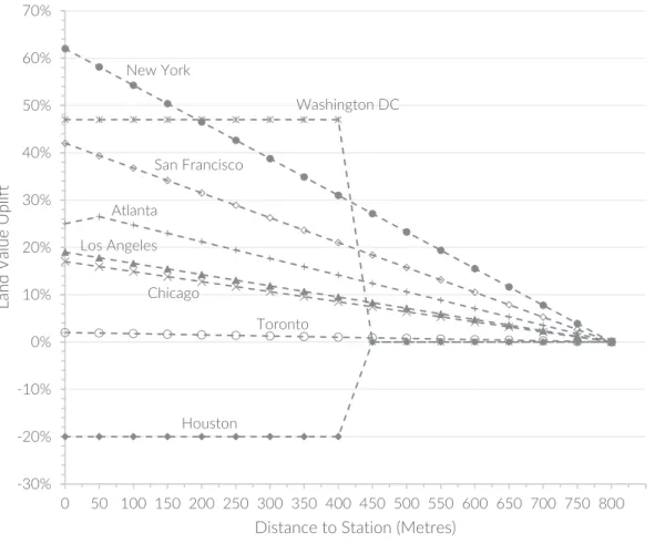
First, it is noted how different kind of transport facilities result in different land value variation outcomes, with subway systems getting the highest premia, compared to light rail and commuter rail (train) systems. Empirical studies of the impact of subway/elevated urban rail systems (often referred to as “heavy rail” or “metro” systems) almost uniformly find positive impacts on home prices or commercial property prices or rents near stations (Higgins & Kanaroglou, 2016): at the high end of this spectrum, a study by Lewis-Workman & Brod (1997) on the subway system of New York City reports a negative gradient of $75 for each additional meter of distance away from a metro station for house prices. According to Iacono et al. (2009), more generally, systems that are more extensive, more heavily patronized and that provide a greater level of accessibility tend to have greater impacts on property values.
25
Figure 4. Land Value Uplift coefficients from study sample. Adapted from Higgins & Kanaroglou (2016).
Further, notwithstanding a general positive impact of the infrastructure project, the immediate surroundings of both the stations and the transit line (this only in the case of above-ground solu-tions) might receive a reduced premium on neighbouring land and property values: this is caused by the negative externalities of the project, such as noise nuisance, increased pedestrian concen-trations, changing patterns of local commercial offer targeting user population and other place specific effects. Chen, Rufolo, & Dueker (1998) concluded that a same infrastructure project may generate multiple counterfactual types of externalities: in their paper, they both noted a positive effect of proximity to light rail stations in Portland and a negative effect of being near the light rail line itself, due to the noise nuisance effect of the light rail passing cars. Lastly, there is some evi-dence that the price effect of being near a station may also depend on socioeconomic characteris-tics of the neighbourhood surrounding the station itself, which may cause reduced – or even neg-ative – land value premia. Effects of proximity to rail stations on residential property values have been found to vary by neighbourhood income in station areas (Bowes & Ihlanfeldt, 2001). Where crime rates are higher compared to other stations or areas of the city, residential property prices
New York Washington DC San Francisco Atlanta Los Angeles Chicago Toronto Houston -30% -20% -10% 0% 10% 20% 30% 40% 50% 60% 70% 0 50 100 150 200 250 300 350 400 450 500 550 600 650 700 750 800
Land Value Uplift
26
in the immediate vicinity of stations may be depressed, especially in lower-income neighbour-hoods (Hess & Almeida, 2007).
Another crucial aspect when trying to compare different outcomes is represented by the incon-sistency of model specification for estimating the proximity effect, which in turn makes compar-isons across studies somewhat difficult: some studies treat distance as a discrete variable and measure effects within distance bands of a given facility while others treat distance as a continuous variable and attempt to recover rent gradients (Debrezion, Pels, & Rietveld, 2007).
In a paper titled “The anticipated capitalization effect of a new metro line on housing prices”, Agostini & Palmucci (2008) studied the impacts of the opening of the line 4 on surrounding real estate values in the city of Santiago, Chile. The authors’ aim was to understand how and when real estate market would transform the absorbed information about the upcoming opening of a new transit line into residential values uplifts. With the use of a unique database containing all home buying and selling transactions in the Greater Santiago area between December 2000 and March 2004, they were able to discover that the average apartment price rose between 4.1% and 7.9% after construction was announced and between 3.9% and 5.4% after the location of the stations was identified. This increase was not distributed evenly, but depended on the distance from the apartment to the nearest station: specifically, it corresponded to the changes in values for those properties located within 1 km from the upcoming metro station.
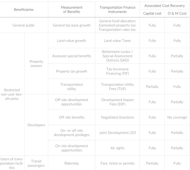
Regarding European cities, which represent a better set to be compared with the case study of this research for the general city structure and socioeconomical aspects, numerous authors have un-dertaken empirical analysis of the land value uplift generated by investment in subway lines in different cities. Medda & Modelewska (2009) have analysed the economic impacts of the existing metro line on housing prices in Warsaw, Poland, and predicted future uplifts in values due to the construction of the second line. The aim of their work is to measure the capitalisation benefits of the metro access, both where the subway is already operating and in the district where the new line will reach. To do so, the authors have run two distinct hedonic regression models, one for the existing line on the district of Bielany and one for the district of Targówek. Each regression con-tains the natural logarithm of sales prices as dependent variable, and a range of property de-scriptors: among them, for each apartment they calculated the direct distance, point-to-point, to the metro station and identify it as a dummy variable (1 if property is within 1 km to station, 0 if
27
distance to station exceeds 1 km). Their assumption is that, given the similar characteristics and trends in the real estate market of the two districts, it is possible to calculate the value of house price in Targówek by introducing in the regression the Bielany coefficient for access to metro. The results show that houses located within a distance of 1 km to the nearest metro station compared with those in the same district but farther away have, respectively, a 6,7% higher selling price in the district of Bielany and a 7,13% higher predicted selling price in the district of Targówek.
Similarly, Efthymiou & Antoniou (2013) studied the interaction between transportation infra-structure and both selling and rent property values for the city of Athens, Greece. After building a dataset of residential selling and renting prices with a web-scraping technique (since real estate transaction were not available), the authors ran several different econometric analyses, including HPM. They concluded that houses located 500 metres around the metro stations have higher pur-chase prices on average between 6.74% and 11.66% and rental price from 4.20% to 6.21%, while those located 500metres around ISAP stations (Athens-Piraeus Electric Railways, the old urban railway of Attica) have sale prices from -10.20% to -12.24% but the effect is significantly smaller on rental (from -1.55% to -1.73%), showing that people are less willing to purchase a house – than to rent one – next to ISAP stations. In his bachelor thesis in Social Sciences at the Institute of Economic studies at Charles University in Prague, Laznicka (2016) studied the impact of metro station proximity on apartment values in Prague, Czech Republic. His research resembles the pre-vious cases, but, concerning the goals, he also controlled for difference in difference within the same transit system by analysing individual stations’ effects on real estate values in different areas of the city individually. The results show that a positive impact of metro closeness prevails in most of the examined suburb stations, while the ones located in the midway to the centre showed di-verse effects on apartment prices and finally, the only station examined that is located in the cen-tre, Staromestska, confirmed the assumption of diminishing benefit of having apartment close to the metro station in the case of the city centre.
28
C
HAPTER2
|
T
HE FUNDING OF PUBLIC TRANSPORT INFRASTRUCTURES AND THE UNEVEN DISTRIBUTION OF GENERATED BENEFITSTraditionally, there have been three main sources to finance urban infrastructure: savings of local governments – with general taxation and user fees as primary revenue sources -, grants from cen-tral government, along with supplemental methods including bonds, loans, public-private part-nerships and concessions (Iacono et al., 2009). Each of these financing methods is now facing constraints. Local budgets are needed to run basic operating services and to maintain existing infrastructure. Central governments must limit grants to cities in the view of judicious fiscal man-agement. Meanwhile, decentralization policies have moved service responsibilities downward, asking local governments to finance more of the urban capital budget with their own resources, but their local taxation revenue base is often insufficient, even just to request borrowings and fund urban infrastructure investment through debt. Furthermore, there is a growing reluctance among voters to pay higher taxes, while at the same time the operating costs of many services has in-creased, along with voters’ expectations for amplified services (Alterman, 1988; Altshuler & Gómez-Ibáñez, 1994; Callies & Suarez, 2004; Nelson, Bowles, Juergensmeyer, & Nicholas, 2008; Rosenberg, 2006). There is a shared consensus that in the last twenty years Italian cities have faced heavy underinvestment concerning the provision of public infrastructure (Calafati, 2009), which began in 2004 and got even worse as an effect of the financial crisis of 2008 (Chiades & Mengotto, 2013; Cogno & Piazza, 2013). Between 2004 and 2012, local administrations’ capital expenses have decreased by 34%, while those of just the major municipalities (accounting for over 60.000 inhab-itants) have dropped by 63% (Camagni, 2014).
The concern about the increasing difficulties of the actual transportation system finance has grown over the years, while the resources to build, manage and maintain such systems have not grown correspondingly, causing the gap between costs and available resources to increase alarm-ingly. The ability of cities to finance the needed infrastructure provision partially depends on their ability to draw from another set of financing methods, with the aim of rebalancing the distribution of the land value uplifts between private and public sector, in favour of the latter – penalized thus far (Camagni, 2016). The set of financing methods is that of Land Value Capture (LVC), which consists on capturing a portion of the increment in property value gains resulting from a
29
transportation improvement, to channel them into the provision of infrastructure finance (Peterson, 2009).
“Land Value Capture in general is a mechanism by which the agency responsi-ble for the development of the urban transport infrastructure captures part of the financial benefits gained by land developers or the community at large. This benefit is reflected in an increase in the real property values, which can be re-garded as a comprehensive index of all the benefits generated by the develop-ment, including improved accessibility and increase in business opportunities.” (Farrell, Tsukada, & Kurawami, 1994)
As the demand for land is a derived demand, its price depends on the potential benefits that it can generate for those who use it2
. Public interventions (including those that allow transformation of land use from rural to urban, provide infrastructure, and permit higher development density) can all increase benefits for the properties impacted. This, in turn, can result in higher land prices. As this value uplift is generated solely by public decisions, investments and interventions, the public has the right to recover this value for the benefit of the community (Blanco et al., 2016).
In an age of extensive fiscal limitation, with the rising awareness that the cost of transport will not be sufficiently met by the existing financing and revenue generation methods, LVC and other alternative sources of capital for financing rapid transit that involve contributions from a range of public and private stakeholders have become increasingly attractive (Z. J. Zhao & Levinson, 2012). Land values are in fact highly sensitive to urban economic growth and infrastructure in-vestment: ceteris paribus, or “all other variables held constant”, housing units that are closer to public transport stations have a higher market value (Higgins & Kanaroglou, 2016; Iacono et al., 2009; Medda & Modelewska, 2009). This effect is explained by the lower cost of transport – ex-pressed in time saved – to the main workplaces, leisure and service areas of the city, which con-verts into benefits that are directly capitalized into nearby land values and housing prices (Agostini & Palmucci, 2008). In fact, if transportation implies a cost for the user in terms of time
2 In urban economics literature, this concept is referred to as “the doctrine of the highest and best use”: the market assigns the property to the use that generates the highest economic benefits, assuming that land is scarce and holding all other factors constant.
30
and individuals try to minimize such costs, an increase in accessibility due to a new transit line translates in improved locational qualities for the area along the transit line, and, more specifi-cally, around its stations. The direct Land Value Uplift (LVU) generated by the construction of a new transit infrastructure can then pile up a variety of cascading positive effects which can all be priced into the urban land market, ranging from land use change (as more valuable land should, in theory, attract more intensive land use development), to a reduction in air pollution, to a pe-destrian friendly Transit Oriented Development (TOD), to a higher-density mixed-use neigh-bourhood. Estimating LVU associated with the effects of transport developments is a crucial step for an evidence-driven policy analysis that must be able to demonstrate the robustness of its the-oretical foundation in the direction of a fiscal reform which aims at introducing LVC methods as a new tool in the hands of the public sector. If it’s proven that a transport infrastructure project generates positive externalities and that these effects are priced into the private land market, there is a claim for the public sector to recapture some of these LVU benefits, also referred to as the “unearned increment”3
, to partially fund the project through localized LVC policy tools (Higgins & Kanaroglou, 2016).
2.1
T
HE RATIONALE FORL
ANDV
ALUEC
APTUREGiven the premises on the budget constraints that cities’ administrations are facing, a key element to stimulate investment in transport infrastructure and attract investors is a conceptual shift about funding mechanisms. Land value capture finance (LVC) is a supplementary method of revenue generation for urban transport systems, which aims at recovering part or all the initial capital cost of the investment by capturing some or all the increase in land value (LVU) secondary to the increase in accessibility. The concept of LVC is sometimes referred to also as Land Value re-Cap-ture, highlighting how this process aims at recovering an initial investment rather than capturing extra revenues. This shift can be realized by unlocking and enhancing urban assets based on their accessibility value, where accessibility is defined as ‘‘the extent to which land-use and transport systems enable individuals to reach activities or destinations by means of transport mode’’ (Geurs
3 Any rise in land values – whether due to public decisions or to the general economy; stressing the fact that the rise is not due to the landowners’ own initiatives and efforts. Used internationally (World Bank, UN, academic literature). (Alterman, 2012)
31
& van Wee, 2004). To investigate the potentials of LVC, it is necessary to incorporate accessibility within a framework of land value finance, where we can link the benefit of transport investment to its costs. Before focusing on the analysis of the different LVC methods that will be unveiled in the following paragraph, this section focuses on understanding why capturing unearned incre-ments in land value can be an ethic solution.
Essentially, the value of land (total land value) is comprised by two components (Figure 5):
(A) The capitalized value determined by accessibility to natural and social resources in the city;
(B) The capitalized value of on-site improvements and constructions.
The capitalized land value of accessibility (A), which more broadly is the focus of this entire thesis, can further be understood as the aggregate value of three major components (Fensham & Gleeson, 2003):
(A.1) ‘social’ infrastructure paid for by government through tax and excise income (i.e. schools and hospitals, public transport, arterial road networks);
(A.2) ‘private benefit’ or ‘development’ infrastructure, that services individual properties paid for through local government levied user charges (i.e. local roads, reticulated water and sewerage, stormwater drainage, local parks);
(A.3) urban externalities (i.e. amenity and aspect, access to services, suppliers and markets).
Figure 5. Total Land Value components and structure of the capitalized land value. Source: Medda (2012)
TOTAL LAND VALUE
(A) Accessibility-related capitalized land value
(A.1) Social infrastructure
(A.2) Individual development infrastructure
(A.3) Urban externalities (B) On-site development-related
32
Intrinsic land value created in this way (A) represents an ‘economic surplus’ that arises inde-pendently of private landowners’ investment in on-site improvements (B). One of the main argu-ments addressing this as a major institutional failure of land markets is that surplus land value is a major and growing source of unearned income for certain economic actors, and acts as a pro-found cause of social and spatial inequalities. The origin of this reflection, still advocated by many economists to date, dates back to the 18th century, when the Scottish economist and philosopher
Adam Smith (1776) first argued that position plays a crucial role in determining land rent value, identifying the cause being products’ transportation cost.
“The rent of land not only varies with its fertility, whatever be its produce, but with its situation, whatever be its fertility. Land in the neighbourhood of a town, gives a greater rent than land equally fertile in a distant part of the country. Though it may cost no more labour to cultivate the one than the other, it must always cost more to bring the produce of the distant land to market.”
(A. Smith, 1776)
Not only would his theory apply to agricultural land, but rather it was a first call to revise the relationship between public and collective effort in providing services and infrastructure on one side, and private revenue on the other.
“Both (urban) ground–rents and the ordinary rent of land are a species of reve-nue which the owner, in many cases, enjoys without any care or attention of his own. A part of this revenue should be taken from him in order to defray the expenses of the State.”
(A. Smith, 1776)
This assumption grew even more in popularity during the 19th century, when the attitudes toward
land began to change with the wealth increasingly deriving from industrial production rather than agriculture. The philosopher and political economist John Stuart Mill, drawing on the work of David Ricardo, noted the disparity between the productive industrialist, whose wealth would gen-erate from its abilities in managing industrial production, and the inactive landowner, whose land increased in value regardless of any input that he might make. Mill was the first who proposed the idea of taxing what came to be referred to as the “unearned increment”. Mill argued that it was
33
totally suitable for the state to take all or part of the land value increase, because that value was being created by the state as a whole, adding that:
“[…] a land tax should not be regarded as a tax at all, but as a rent reserved from the beginning by the State, which has never belonged to or formed part of the income of the landlords.”
(Mill, 1848)
Following on Mill’s idea, Henry George, the political economist, argued that land taxes are equi-table because the value of land is determined by community effort, not by individual effort:
“[…] public capturing of land values represents a taking by the community, for the use of the community, of that value which is the creation of the community.” (George, 1879)
Another great defender of this theory was the British politician Winston Churchill, who spoke in the House of Commons in 1909 putting this argument eloquently:
“Roads are made, streets are made, services are improved, electric light turns night into day, water is brought from reservoirs a hundred miles off in the mountains – and all the while the landlord sits still. Every one of those improve-ments is effected by the labour and cost of other people and the taxpayers. To not one of those improvements does the land monopolist, as a land monopolist, contribute, and yet by every one of them the value of his land is enhanced. He renders no service to the community, he contributes nothing to the general wel-fare, he contributes nothing to the process from which his own enrichment is derived.”
(Churchill, 1909)
In more recent times, the evolution of this concept, particularly when related to the funding of public transit infrastructure, was theorized by Joseph Stiglitz (recipient of the Nobel Memorial Prize in Economic Sciences later in 2001) who formalized these elements into a theorem – the so-called Henry George theorem – in which he demonstrates that, under certain conditions, the total
34
final revenue increase is equal to the total cost of a public asset (Stiglitz, 1977). This idea was stated most forcefully by Donald Shoup, who asked in his famous assertion on the urban underinvest-ment anomaly:
“Why is it so difficult to finance public infrastructure that increases the value of the serviced land by much more than the cost of the infrastructure itself?” (Shoup, 1994)
The underlying rationale of the Smithian argument is still compelling to many, and it is often cited in support of the idea that the added value specifically created by land-use regulation and infrastructure improvement decisions should be shared with the public (Alterman, 2012). Nowa-days, the indications of supranational agencies and international study centres are more and more oriented towards suggesting the local application of differentiated value recapture and value shar-ing practices.
“The unearned increment resulting from the rise in land values resulting from change in use of land, from public investment or decision, or due to general growth of the community must be subject to appropriate recapture by public bodies (the community), unless the situation calls for other additional measures such as new patterns of ownership, the general acquisition of land by public bodies”
(UN-HABITAT, 1976)
The recapture and a more equitable sharing of the LVU between private and public sector would trigger a cumulative virtuous circle: agglomeration advantages attract new activities and generate growth; growth generates revenues (company profits, wages and above all rents) from which it is possible to find the resources for the new public goods, infrastructures and services that further revive the growth process (Figure 6).