G.I.S. & URBAN DESIGN #11 - aprile 2013
ISSN 1828-5961
DISEGNARECON
Carmen Cárcel García
Architetto alla “Escuela Técnica Superior de Arquitectura” (ETSA) dell’Universitat Politècnica of Va-lencia (UPV). Profesore Associato alla “Escuela Técnica Superior de Ingeniería en Edificación” (ETSIE) dell’UPV, nel Dipartimento di “Expre-sión Gráfica Arquitectónica” (DEGA).
Francisco Juan Vidal
Architetto alla “Escuela Técnica Superior de Arquitectura” (ETSA) dell’Università Politècnica di Valen-cia (UPV). Dottorato alla UPV. Profes-sore alla ETSA/UPV, nel Dipartimento di “Expresión Gráfica Arquitectónica” (DEGA). Ricercatore all’ “Instituto de Restauración del Patrimonio” (IRP) della UPV.
Dalla seconda metà del XX secolo c’è una cresci-ta diffusa e incontrollacresci-ta dei centri storici urbani, basata su piani urbanistici con tracce anarchiche che hanno generato una rottura con il naturale processo evolutivo della città. La nostra proposta cerca di acquisire un nuovo impegno verso mo-delli contemporanei di sviluppo urbano, nel ten-tativo di ristabilire l’ordine naturale della crescita e della trasformazione del paesaggio. Abbiamo documentato, con una ricerca su un caso parti-colare della “Huerta” Storica di Valencia (Cam-panar), l’analisi del suo tessuto urbano e gli ele-menti di articolazione che hanno condizionato la crescita nel tempo rispettando il suo assetto originale.
Since the second half of the 20th century an un-controlled and generalized growth of historic ur-ban centres takes place, based on anarchic town-planning that causes a break with the natural evolutionary process of these cities.
Our proposal aims to make a commitment with the new contemporary urban development mo-dels, in search for characteristic links that reesta-blish the natural growth and transformation of the landscape. Therefore, we have designed the investigation project on the specific case of the Valencian Historic Huerta (fertile, irrigated area), (located at Campanar). We analyze its urban fa-bric as well as the elements that have determined its growth over the years while we respect its ori-ginal appearance.
La ricerca di collegamenti identificativi del territorio garantisce un miglioramento
della pianificazione dell’attuale paesaggio urbano
The search for identifying links of the territory guarantees an improvement
of current urban landscape planning
Parole chiave: pianificazione urbana; collegamenti
identificativi; patrimonio del paesaggio.
Keywords: planning cities; identifying links; landscape and heritage
ISSN 1828-5961 La ricerca di collegamenti identificativi del territorio
In the area around Valencia scope most of the urban centres have been founded in medieval times. The establishment of these urban centres, “ex novo”, was due to the colonization of new lands as well as to the reorganization of the rural population in new urban settlements. It has been proven by various studies that modifications of these urban centres until the first half of the 20th century were minimal (Arizaga 2002). We can therefore assure that the evolution of these settlements over time, has caused transformations in the buildings but has preserved, more or less intact, the original structures and has nearly entirely maintained the
urban landscape. This is proven by the veracity or similarity of many old maps with the reality of their century, being able to rebuild villages from before this century almost without mistakes. The constituent elements of the historic fabric, like parcels, roads, ditches, landmarks, etc. can be appreciated in a map as traces/marks that have been maintained in the area throughout time without almost any modifications.
But, what caused this transformation that started at the second half of the 20th century? One of the factors that contributed significantly to this urban metamorphosis was, without doubt, the
increase of the population caused by the birth rate increase and the rural exodus that caused the uncontrolled population growth in the cities. In the same way, the huerta that was conserved for ages is starting to be threatened. It suffers from this uncontrolled increase that razed irrigated land close to the cities, which is the case of the peri-urban settlements of the Historic Huerta of Valencia.
This uncontrolled increase of the urban centres was and still is a generalized phenomenon that concerns historians and archeologists, as well as architecture and urbanism students, because Fig 1. Aerial view of the old part of Campanar surrounded by the huerta little before the unfortunate urban development. Photo map of Valencia (1944).
33 #11 - aprile 2013
ISSN 1828-5961
DISEGNARECON
La ricerca di collegamenti identificativi del territorio Carmen Cárcel García | Francisco Juan Vidal G.I.S. & URBAN DESIGN
this produces a break in the evolutionary process of the cities. Many changes made since the second half of the 20th century were the result of inappropriate development politics, with a thoughtless planning vision, that raised aggressive urban actions that have destroyed, in most cases, traditional town and country planning. This vision is different from today’s that is more respectful of the land and of the survival of historic heritage. (Fig. 2)
Today’s historic sensibility regarding the preservation of historic settlements is linked to the reconstruction plans made after the Second
World War, in 1945. The need to rebuild cities and to restore the destroyed architectural heritage conceived plans that state the interest of preserving buildings and give them artistic and historic value. One of the first statements in Spain took place in 1958, during the first Congress of the Urban Institute that recognized that ongoing conservation projects were adopted to isolated buildings, without taking into account the immediate urban surroundings. It was not until 1964, with the Venice Charter1 that the
need to preserve historic heritage became clear. This declaration stated for the first time that the concept of historic heritage was not only limited
to isolated monumental projects, but that it encloses the urban or rural setting where they are located. Only in these circumstances a monument acquires its genuine historical consciousness of its raison d´être. This vision of historic heritage that extends its borders to the immediate surroundings allowed the safeguarding, by public administrations, of many rural settlements that were threatened by urban voracity. In the specific case of our study, Campanar, the BIC2
declaration from the church and later from its environment, achieved the preservation of this traditional centre of the huerta.
It was in the eighties that a broader view on the subject to be preserved was adopted, expanding the architectonical heritage field to urban areas and their environmental setting. At this moment, a development of conservationist policies with varying degrees of success takes place. According to Arizaga, one of the causes of the lack of success of some of the projects was due to the lack of ambition of these policies. They intervened the building without previously having made an in-depth analysis about its origins and its historic surroundings, and obtained as a result some renovated buildings that lacked any traditional context. We had to wait until the 1992 Congress on Urbanism and Preservation of World Heritage Cities3 where these effects and the need to
socialize these historic centres were debated to guarantee their survival.
Obviously, it is easy to assume that these preservation policies have been developed based on architectural and historical recognized Fig. 2. The map clearly shows the new expansion of the old area of the Huerta and the camino de Tránsitos (roadway) as separation axis between the city and the huerta. Overall map of Valencia. 1925
ISSN 1828-5961 La ricerca di collegamenti identificativi del territorio
35 #11 - aprile 2013
ISSN 1828-5961
DISEGNARECON
La ricerca di collegamenti identificativi del territorio Carmen Cárcel García | Francisco Juan Vidal G.I.S. & URBAN DESIGN
buildings and urban settlements, risking the fate many architectural non-catalogued objects that form an essential part of a cities history, and are recognized as Small Heritage. It is obvious that the value of this small heritage is not artistic but historic. The rural settlements with its concentrated or widespread houses, farmhouses, the Historic Huerta and its hydraulic irrigation system, the artifact millers, etc. are some examples of small heritage sites that, contrary to the world heritages, reflect everyday society. Only safeguarding monumental heritage can falsify the real history of a population, by ignoring the concept of urban landscapes as a lively place that is constantly changing.
Our last thought on the concept of a minor heritage, in the case of the peri-urban settlements in the city of Valencia, like Campanar, Benicalap, Benimaclet, Patraix, …etc of which their origins are linked to its Historic Huerta, is that we have to reconsider the subject of our investigation, not as an isolated element, but as part of this traditional landscape. But how can we investigate the origins of a historic landscape which is continuously changing? A new investigation challenge on heritage is presented which forces to carry out a multidisciplinary approach according to a sustainable vision and a solid archeological basis. One of the methodological trends in this field is the so-called “landscape archeology” argued by Antonio Malpica 4.
One of the complementary disciplines embedded in this methodology, is outlined by R. González Villaescusa (1996) as essential for the understanding of a rural landscape like the Valencian Huerta, which is active and continuously changing. We refer to the morphological method, based on the interpretation of the landscape structure based on photographs, cartographies, property registers, etc., and the subsequent diachronic analysis that is needed to assess the obtained data. This is an ideal method for a first understanding and hypothesis formulation on the construction and deterioration of a rural scene. The subsequent integration of the archeological
data and the combination of both methods enrich the investigation results.
Following this theory, to acquire a commitment with new urban development models, we think it is necessary to find and identify the characteristic links of the landscape that allow to restore the natural growth and respectful transformation of the affected heritage. Following this premise, the objective of our investigation, based on the morphological method, is to detect in the configuration of Campanar those landmarks that characterize and have influenced urban traces of this historic landscape for years. Based on historic cartography and archival sources, we have analyzed its urban fabric as well as the elements that have determined its natural growth in
coherence with the landscape. Therefore we have selected, from an extensive cartography, those maps that provided us with graphic information on the Campanar area in different periods and circumstances. We have studied different maps to find different latent elements on every map and, finally, we have compared the obtained results of each map. Interesting information has made us demonstrate which were the elements that were reproduced by the authors with mayor assiduousness and which were used to identify the Campanar area.
A good cartographic analysis cannot be made, of course, without a significant documentary basis based on the knowledge of the history and morphology of the Huerta. This study allows an in-Fig. 4 and 5. Observe the characteristic appearance of Campanar in detail at the map of the City of Valencia being tackled by Mariscal Moncey, 1808 (left) and the map of Valencia and its surroundings. 1883 (right). Herrera et alii, 1985.
ISSN 1828-5961 La ricerca di collegamenti identificativi del territorio
depth investigation of the landscape to be studied and, consequently, reinforces the sometimes confusing information obtained from the maps. It is therefore important, before immersing oneself in the analysis of maps, to know the factors that characterize and define the structural fabric of the huerta like the hydraulic infrastructure, the road network, the parcel regularization or the different types of buildings. Based on these factors we will expose the results of the first morphological approach of the Campanar area. Valencia´s proximity to the sea, the river Turia´s characteristics as well as its climatology, have led to frequent flooding (Almela y Vives, 1957), specifically in the surrounding peri-urban area, that is related, during its entire history, to water and irrigation. This situation was used by the ancient inhabitants of these lands to develop a widespread and complex irrigation system that came to its culmination in the Muladi period (Guinot, 2005) and that is very well reflected at Cavanilles (1795) map presented in figure 3. Especially the lands of Campanar are irrigated by the ditches of Mestalla, Tormo and Rascaña. The sinuous layout of the three ditches, as well as the junctions between them, respond to an adaption criterion to the land and parcel´s orography, and to the different construction periods (Glick, 2000). We also have to take into account the double functionality of the water. It did not only serve as an irrigation system to cultivate land, but it also was the driving force behind the hydraulic artefacts (Roselló, 1989) and it therefore occupied the beginning of the ditches. The appearance of the irrigation system acquires a specific layout in Campanar´s landscape. It provides a characteristic and exceptional image, while the mill layout, as a reference, can be clearly identified in the different contrasted cartographies.
Regarding the historic communication ways in the huerta we have to distinguish between roads that connect highly concentrated villages and those secondary roads that allow the access to scattered settlements. As we can notice in the map of Cavanilles, a network of royal routes
that crossed the huerta existed. These routes communicated the important centre with rest of the peripheral villages by trunk roads, highlighting the Morvedre royal road starting at the entrance of Serranos (Roters), as main axis of the northern
Huerta and the royal roads of Xátiva, by San
Vicent (Boatella) and of Quart by the city gate that has the same name, both main roads of the southern Huerta (Huici, Cabanes, 1976).
In the case of Campanar, this hierarchy between
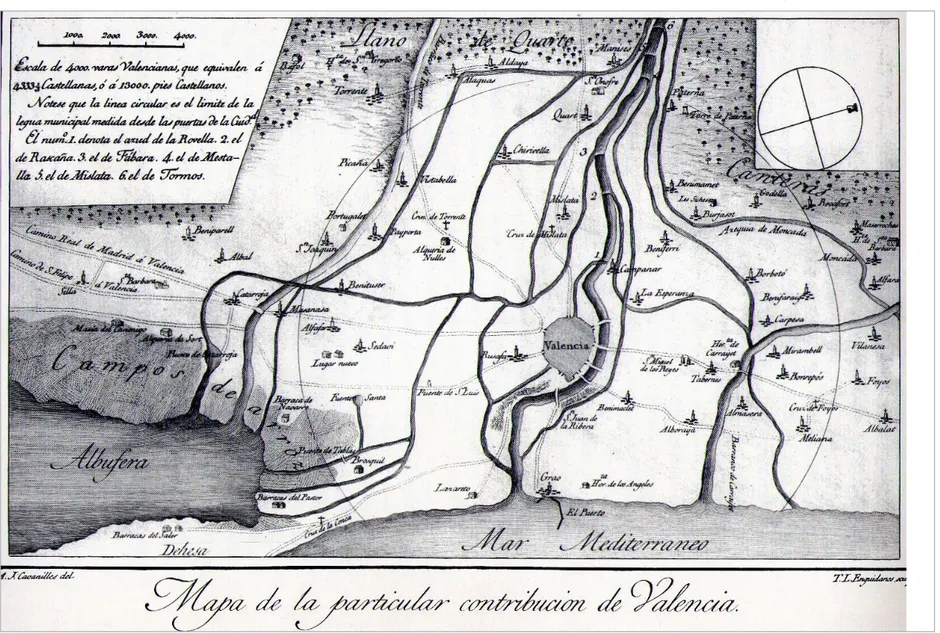
the Campanar and Pouet road is easy to see. The first road appears on every analyzed map when the city is communicated with the Campanar area, while the second road hardly appears on any map, specifically not on the eldest ones, because it was a path that communicated the isolated settlements of the huerta. Comparing the different maps we can notice a possible transformation of the Camí del Pouet as a path to an important commercial transaction road to the city. The map of 1808 (fig. 4) shows the Fig. 6 Map of the Huerta and Specific Contribution of Valencia, by Francisco Cassaus, 1695. Colletion José Huguet.
37 #11 - aprile 2013
ISSN 1828-5961
DISEGNARECON
La ricerca di collegamenti identificativi del territorio Carmen Cárcel García | Francisco Juan Vidal G.I.S. & URBAN DESIGN
minimal presence of isolated settlements next to the farms without detecting any trace of a road in the area. Nevertheless, the map of 1893 (fig. 5) not only shows the described road but its side view passing the huerta from the margins of the Turia river until the old Campanar road and a trail of Farmhouses that start to settle the idea of a commercial road. The confirmation of this conversion of a path into road is provided by the dossier that is written up for the license request for the construction of the road in 1853 5.
On the other hand, we should not forget that we are dealing with a territory that is mainly dedicated to the agricultural exploitation on the land and to the water resource management. Therefore, it is easy to understand that the first settlements were developed around autarkic farmhouses and cultivated land. When we observe a map we can consider, at first glance, that this type of scattered settlements is anarchic and unorganized, far from reality. V. Algarra (2003) defends a precise organization model with farm units that have a farmhouse as crucial centre (del Rey, 1998). To demonstrate this theory he suggests us to analyze the map of the Huerta and Specific Contribution to Valencia of 1695 (fig. 6) where we can appreciate this scattered effect of in the landscape without apparently any logic settlement structure. But if we take a closer look, we can appreciate a systematic order in these residential units. We can even suspect the measurement unit that separates these enclaves in equivalent distances. This rhythmic order that is repeated on the map along the roads arises from a logical conception of the redistribution mechanism of the land for its correct exploitation and was carried out with the repartiment driven by King Jaime I after Valencia´s conquest in 1238. Following E. Guinot (2008) in his parceling study, this division of the land in plots based on a new metric system, the jovada, took place, as far as circumstances permitted, in an efficient way. In this way, we can easily detect a homogeneous parcel in sparsely populated zones, where it had been possible to redistribute the land,
and densely populated zones with agricultural exploitation, like the historic Huerta, where in most cases, one had to adapt to the existing buildings and to the primitive parceling module. The map of Cassaus (fig. 6) shows us a rhythmic order of buildings close to newly constructed roads. These roads can be recognized by their straight layout, for example the Torrente road. Nevertheless, the high density of settlements in the Campanar zone makes it difficult to distinguish this rhythmic order to which V. Algarra is referring. The farmhouses are scattered on the map without link to the outlined roads. This makes us think that all these farmhouses were subject to secondary paths and roads, like the Pouet roud, that followed the same order as the main roads. When we compare the different planimetries and look at the two examples (fig. 4 and 5), we can assure ourselves that there are specific settlements that are repeated in both maps. We have proven, because of their situation, that in some cases these were mills and in others farmhouses. While the mills were easy to identify, the farmhouses were difficult and in some cases impossible to identify because of the lack of data. On the contrary, the settlement on Campanar´s main road can be identified on any planimetry, because it maintains this meandering configuration like the road´s structure. The interesting object of the next phase in the analysis is to study the growth of this small population around the primitive farmhouse (Torró, 1990), maintaining the landscape´s natural morphology intact.
The initial results of this investigation project allow us to state the importance of carrying out an in-depth analysis of the planned landscape that confirms a thorough knowledge of the entity. Based on historic cartography and archival sources, by comparing data, we can thoroughly study the genesis of any urban settlement and therefore get to know those identifying links preservation of which allows us to develop urban models that are more appropriate to the natural evolutionary process.
ISSN 1828-5961 La ricerca di collegamenti identificativi del territorio
BIBLIOGRAFIA
Almela i Vives, Francesc., 1957, las riadas del Turia (1321-1949), Ayun-tamiento de Valencia.
Almela i Vives, Francesc., 1932, Alquerías de la huerta de Valencia, Valencia.
Almela i Vives, Fransesc., 1960, La vivienda rural valenciana, Valencia. Aguilar, Rosa Mª., 1985, Campanar desde sus orígenes, J. Aguilar. Va-lencia.
Algarra, Victor y Berrocal, Paloma., 1999, “La ciudad Barroca. Los poblados en la particular Contribu-ción”, Historia de Valencia, Cap. 26, Universidad de Valencia – Levante – EMV, Valencia.
Algarra, Victor, 2003, La rambleta de la huerta de Favara: patrimonio histórico y natural de la ciudad de Valencia. Ayuntament de Valencia. Arízaga, Beatriz, 2002, La imagen de la ciudad medieval. La recuper-ación del paisaje urbano. Servicio de Publicaciones de la Universidad de
Cantabria, Santander.
Cavanilles, Antonio, 1795, Obser-vaciones sobre la historia natural, geográfia, agricultura, población y frutos del Reyno de Valencia, Ma-drid.
Glick, Thomas, 2000, Els molins hidráulics valencians: Tecnología, historia i context social. Valencia, Institusió Alfons el Magnánim. González, Ricardo, 1996, Paisaje agrario, regadío y parcelarios en la huerta de Valencia, nuevos plant-eamientos desde el análisis mor-fológico, II Coloquio Historia y Medio Físico. Agricultura y regadío en al-Andalus. Almería.
Guinot, Enric, 2005, Les séquies de l´horta Nord de València: Mestalla, Rascanya i Tormos. Camins d´aigua, el patrimonio hidràulic valencià. Generalitat Valenciana, Consellería d´Agricultura, Pesca i Alimentació. Guinot, Enric, 2008, El paisaje de la huerta de Valencia. Elementos de interpretación de su morfología espacial de origen medieval Historia de la Ciudad V. Tradición y progreso.
NOTE
1 International charter on the con-servation and restoration of monu-ments and sites.
II International Congress of archi-tects and Historic monuments tech-nicians, Venice 1964
2 Assets of Cultural Interest (BIC). Declaration dates: DOGV 10.05.1992 and DOGV 05.10.2007.
3 Urbanism and Conservation of world heritage cities. International Congress. Cáceres 1992. 4 Malpica Cuello, Antonio. Professor of medieval history at the Granada University.
Belongs to the group of Investiga-tion, Toponymy, History and Archeol-ogy of the Kingdom of Granada. 5 Governmental file on the construc-tion of the road directed to Pohuet. Campanar, 1853. Public work 1840-1884. PU 38-39, annexed villages, nº 11. Valencia´s Municipal Histori-cal Archive.
COACV. Valencia. (pp. 98-111). Hermosilla, Jorge, 2007, El patrimo-nio hidráulico del Bajo Turia: l´Horta de Valencia. Generalitat Valenciana, Dirección gral de Patrimonio Cultural Valenciano.
Herrera, et alii, 1985, Cartografia històrica de la ciudad de València. 1704-1910, Ajuntament de València. Huici, Ambrosio. y Cabanes, Mª D., 1976, Documentos de Jaime I de Aragón. II (1237-1250) Zaragoza. Llopis, Alonso y Perdigón, Luis, 2010, Cartografía histórica de la ciudad de Valencia. 1608-1944, Universitat Politècnica de Valéncia.
Mangue, Ignasi, 2001, Marxalenes: de alquería islámica a barrio de la ciudad de Valencia. Ayuntament de Valencia.
Ortega, José. 1998: “El patrimonio territorial como recurso cultural y económico” Ciudades, 4. Territorio y Patrimonio, Valladolid, Instituto de Urbanística de la Universidad de Val-ladolid.
Rey, Miguel del, 1998, Arquitectura
Rural Valenciana: tipos de casas dis-persas y análisis de su arquitectura, Generalitat Valenciana.
Roselló i Verguer, Vicent. Mª., 1989, Els molins d´aigua de l´Horta de València. Los paisajes del agua. Uni-versitat de Valencia.
Sanchis, Manuel, 1981, La ciudat de Valéncia. Sintesis d´historia i de Geografía urbana. Ajuntament de Valéncia.