731
7th EUREGEO 2012 Session 11 - Poster
THE GIS BASED ANALYSIS AND THE TERRITORIAL MANAGEMENT
Vittorio Amadio
(1); Francesca R. Lugeri
(2);Nicola Lugeri
(2); Barbara Aldighieri
(3); Bruno Testa
(3)(1)Università Mediterranea. C.da Melissari - Feo di Vito - 89124 Reggio Calabria [email protected] (2) ISPRA - Istituto Superiore per la Protezione e la Ricerca Ambientale - Via Brancati 48, 00144 Roma.
[email protected]; [email protected]
(3) CNR IDPA Istituto per la Dinamica dei Processi Ambientali. Via Mario Bianco, 9 - 20131 Milano [email protected]; [email protected];
KEY WORDS: Map; GIS; Landscape; Territory; Knowledge; Elba Island;
THE GIS MULTI-SCALE ANALYSIS
The knowledge of the territory and the transmission of the knowledge is a necessity that still holds great importance and influence in the political and economic development of the contemporary society.
The physical, natural, social and economic sciences, have often a common factor: the “land”, both as object of study and as a “landmark” for the research on phenomena and processes.
The recent development of GIS based mapping, optimized for the Web, has allowed an opening to the public until a few years ago unthinkable.
In the case of geological/ecological data bases, the Geographical Information Systems are the most complete tools, in terms of logical structure, versatility and upgradeability.
Referring to the thematic maps, the GIS offer all the prerogatives typically required by the use of such techniques: to provide a reliable tool, accurate and well-timed (both in terms of upgradability and speed of access). The structuring of the information becomes essential; this kind of technological approach allows the management of a simultaneous presence of data from different sources and on different scales, as well as the integration of interpretative and evaluative models, useful as decision support in the territo rial planning activities. Versatile and user-friendly (also referring to the traditional cartographic output) GIS keep track of the changes (both to the geometric and alphanumeric data) as well as of the access to geographic data base.
In the geological/ecological mapping projects, the multi-scale GIS feature allows the identification of homogeneous territorial units, to which is referred a set of information, following the more significant criteria at the selected scale of analysis.
Remote Sensing and semi-automatic image classification processes, supervised through field controls, represent the procedure followed in order to identify and map the homogeneous territorial
areas. The “multi-scalarity” represent one of the most important peculiarity of the Geographical Information Systems. The set of polygons identified (at each scale of analysis) represents only one of several layers of information managed by the GIS. The combination of information extracted from the related data consistent with the geometric congruence of positioning, allows a wide range of territorial interpretations, available to the decision makers (or more generally to the end users) as applicable solutions.
Today, GIS are the logical choice for the structure of a database scheme, particularly referring to the geo-environmental ones. The tolerances are generally chosen according to the fairness to the different scales. The description of each polygon identified and mapped, is handled in two ways: a short description is stored in the polygon attribute table connected to the map, to be displayed by the built-in tools of the GIS; more detailed descriptions are stored and displayed by customized user interface within the same project, which includes links between maps at different scales
A CASE STUDY: THE ELBA ISLAND
A multi-scale Landscape analysis has been performed in the Elba Island (in the Tyrrhenian Sea). The territory has been analized at three different scales:
1:250.000 –physiographic unit
1:50.000 – Biotope (CORINE classification - EEA) (Carta della Natura project)
1:10.000 - Ecotope
In the most recent approach to geo-environmental analysis, the relationships between the components of landscape and environment are very close, as well as the physical and the biological phenomena. Environmental diversity can be considered the result of the integration between biodiversity and geodiversity: its conservation must take into account the integrated studies on geological heritage, habitats and ecosystems. The multi-scale analysis highlights the components of an area, allowing a complete recognition of the territory. In Particular, at a detailed scale, like the 1:10,000 scale, a
732
7th EUREGEO 2012 Session 11 - Poster
territorial analysis performed following the so-called Landscape approach, provides a readout of the environmental components that integrates the geo-morphological, lithological, biological/vegetational data. At this scale the environmental unit of reference, can be described as an “Ecotope”, following the interpretation given by Carl Troll (1950) “the smallest spatial object or component of a geographical landscape” applying to landscape ecology the former definition of Sir Arthur Tansley (1939): “the particular portion..., of the physical world that forms a home for the organisms which inhabit it”. The new experimental phase of the mapping projects, which integrate geological, morphological and ecological components, can be usefully applied to territorial planning and management. The concept of ecotope gives a geographical-territorial contextualization to an ecological-environmental study, containing the concept of “environmental diversity”, understood as the integration of geodiversity and biodiversity.
The aim to protect places of significant environmental interest, derives from the need
to guarantee a conscious and enjoyable use of landscape in all its forms for future generations, activating an appropriate management of the environment by way of processes based on knowledge.
Figure 1 – Map of Physiographic Unit of Elba Island (Carta della Natura Project – ISPRA)
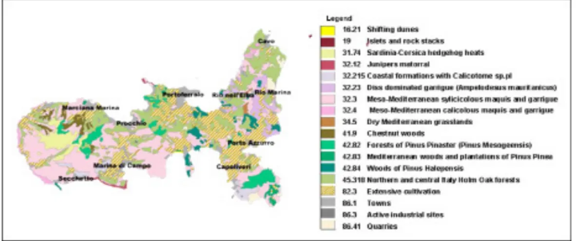
Figure 2 – Map of the habitat of Elba Island (Carta della Natura Project – ISPRA)
ACKNOWLEDGEMENTS
We are grateful to the Carta della Natura Survey team.
REFERENCES
AMADIO V. (2003) - Analisi di sistemi e progetti di pae-saggio. Franco Angeli, Milano, pp 236.
AMADIO V, AMADEI M, BAGNAIA R, DI BUCCI D, LAU-RETI L, LISI A, LUGERI FR & LUGERI N, (2002) The role of Geomorphology in Landscape Ecology: the Landscape Unit Map of Italy’, Scale 1: 250,000 In: Allison RJ (ed) “Applied Geomorphology: theory and practice”. John Wiley & Sons, London, pp 265-282 APAT (2003) - Carta della natura alla scala 1:250,000:
metodologie di realizzazione. APAT, Manuali e linee guida 17/2003, Roma, pp 103
FORMAN RTT, GODRON M (1986) Landscape ecology. John Wiley and Sons, NewYork, pp 620
ISPRA (2009 a) - Il progetto Carta della Natura alla scala 1:50,000. Manuali e Linee Guida 48/2009, Roma pp 128
LUGERI FR., AMADIO V., BAGNAIA R., CARDILLO A. LUGERI N. - Landscapes and Wine Production Areas: a Geomorphological Heritage. Geoheritage - Volume 3, Issue 3 (2011), Page 221-232 Springer Verlag Hei-delberg
PANIZZA M, PIACENTE S (2003). Geomorfologia Cultu-rale. Pitagora Editrice, Bologna, pp 350
SESTINI A. (1963) Il Paesaggio, Collana Conosci l’Italia, vol. VII, Touring, Milano
TROLL C (1950) Die geografische Landschaft und ihre Erforschung. Studium Generale 3: Springer, Heidel-berg.163-181.