Pliocene –Pleistocene geomorphological evolution
of the Adriatic side of Central Italy
BERNARDINO GENTILI
1, GILBERTO PAMBIANCHI
2, DOMENICO ARINGOLI
2,
MARCO MATERAZZI
2 and MARCO GIACOPETTI
21School of Architecture and Design, University of Camerino, Italy
2School of Science and Technology, University of Camerino, Italy; [email protected] (Manuscript received December 10, 2015; accepted in revised form November 30, 2016)
Abstract: This work is a significant contribution to knowledge of the Quaternary and pre-Quaternary morphogenesis of
a wide sector of central Italy, from the Apennine chain to the Adriatic Sea. The goal is achieved through a careful analysis and interpretation of stratigraphic and tectonic data relating to marine and continental sediments and, mostly, through the study of relict limbs of ancient landscapes (erosional surfaces shaped by prevailing planation processes). The most important scientific datum is the definition of the time span in which the modelling of the oldest morphological element (the “summit relict surface”) occurred: it started during Messinian in the westernmost portion and after a significant phase during middle-late Pliocene, ended in the early Pleistocene. During the middle and late Pleistocene, the rapid tectonic uplift of the area and the climate fluctuations favoured the deepening of the hydrographic network and the genesis of three orders of fluvial terraces, thus completing the fundamental features of the landscape. The subsequent Holocene evolution reshaped the minor elements, but not the basic ones.
Keywords: planation surfaces, marine sediments, continental deposits, Pliocene –Pleistocene, central Apennines,
Peri-Adriatic belt.
Introduction
This paper describes the landscape geomorphological evolu-tion of the Apennine and the Peri-Adriatic belt of the Marche region, through the analysis and interpretation of past and new data from recent and detailed geological and geomorphologi-cal analyses. This geomorphologigeomorphologi-cal “model” can be extended, despite local and at times marked differences, even to the neighbouring central-northern Abruzzi region sector (Fig. 1).
The study is focused to the Plio–Pleistocene geomorpho-logical evolution, when the structuring of the fundamental fea-tures of the present landscape took place. In fact, during the Holocene, the origin and evolution of a rural and urban land-scape, which represent the most important human impact on the territory, did not change the fundamental features but only the minor landforms.
The Umbria-Marche sector of the central Apennine ridge represents, because of its unique and continuous lithostrati-graphic sequences and the particular “exposures” of tectonic elements, a territorial unit of great scientific interest. Analysis and interpretation of the geological setting, mostly carried out in the last forty years, reached a high level of detail. Neverthe-less, Quaternary and pre-Quaternary morphogenesis, espe-cially for the Pliocene–Pleistocene period, is still poorly known, mostly concerning time and manner of the main morpho-evolutive stages as well as the role played by the various control factors.
The oldest geomorphological elements in the study area consist of several generations of low-relief erosion surfaces:
the most ancient ones, generally pre-Quaternary in age, characterize the mountain ridges, while the hilly reliefs are the youngest. These elements, whose genesis and evolution has been attributed to different planation processes, have been recognized by several authors in all parts of the Italian penin-sula (Demangeot 1965; Bernini et al. 1977; Bartolini 1980; Sestini 1981; Calamita et al. 1982; Ciccacci et al. 1985; Brancaccio et al. 1991; Dramis et al. 1991; Veneri et al. 1991; Dramis 1992; Nesci et al. 1992; Calamita et al. 1994; Bosi et al. 1996; Chiarini et al. 1997; Amato & Cinque 1999; Calamita et al. 1999; Gentili & Pambianchi 1999; Coltorti & Pieruccini 2000; Schiattarella et al. 2003; Della Seta et al. 2008).
During the Quaternary this “smooth” landscape underwent deep changes as a result of a strong tectonic uplift. The associa-ted tectonic elements with prevalent extensional kinematics (mainly NW–SE and WSW–ENE oriented) created tectonic basins, slope deformations and hydrographic network setup. The coeval and marked climatic oscillations and the alterna-tion of fluvial and marine erosion /sedimentaalterna-tion phases, induced several processes (Calamita et al. 1982; Gentili & Pambianchi 1987; Coltorti et al. 1991; Nesci & Savelli 1991; Calamita et al. 1994; Coltorti & Farabollini1995; Coltorti et al. 1996; Fanucci et al. 1996; Cello et al. 1997; Calamita et al. 1999; Nesci et al. 2002; Aringoli et al. 2007, 2008, 2010; Materazzi et al. 2010; Nesci et al. 2012; Aringoli et al. 2014):
• the partial filling of the tectonic basins due to the deposi-tion of powerful lacustrine and fluvial-lacustrine sedi-ments, including clays and gravels, sometimes alternating with thin layers of volcanic ash;
7 GEOMORPHOLOGICAL EVOLUTION OF THE ADRIATIC SIDE OF CENTRAL ITALY
• opening and deepening of river valleys, characterized by the presence of four main orders of alluvial terraces; • genesis of a shoreline characterized by alternating
wide sandy-gravelly beaches and mostly inactive sea-cliffs.
Moreover, the main rivers which transversally cut the region from the Apennine chain to the Adriatic Sea, created (Calamita
et al. 1994; Gentili & Pambianchi 1994; Gentili et al. 1995 and 1998; Dramis et al. 1995; Aringoli et al. 1996; Fanucci et al. 1996; Di Bucci et al. 2003; Aringoli et al. 2010):
• narrow and deep valleys within the Apennine ridge; • gentle landforms with marked isolated reliefs
(insel-bergs), in the pedemountain belt;
• cuesta morphologies in the hilly Peri-Adriatic belt.
Fig. 1. a — Geological sketch of the study area; b — schematic geological cross-section from the Apennine chain to the Adriatic sea.
The following are associated with the intense deepening of the hydrographic network:
• wide and deep phenomena (even though without clear diagnostic elements) induced by gravitational tectonics; • deep-seated gravitational slope deformations (DSGSD)
and landslides..
The chronology of the initial phase of landscape modelling, as well as subsequent ones, is difficult using only geomorpho-logical data; integrating and comparing data from tectonic- sedimentary studies is therefore fundamental.
Geological and geomorphological setting
The Umbria-Marche Apennines consist of two different ridges that merge to the south, creating the Sibillini Mountains massif (Fig. 1); a short description of the stratigraphic type sequence, mainly based on the stratigraphic schemes worked out by M. Chiocchini, P. Didaskalou, A. Micarelli and M. Potetti as part of the projects aimed at compiling the Geo-logical Map of the Marche Region (Centamore et al. 1986; Regione Marche 2001; Pierantoni et al. 2013) will be given next.The base is given by the “Calcare massiccio” formation (Early Jurassic), a thick calcareous complex, approximately 700 m thick, disarticulated into a “horst and graben” system by the Jurassic extensional tectonics. The “Corniola”, “Bosso” and “Calcari diasprigni” formations (Early Jurassic–Late Jurassic) are visible above, corresponding to the deepest sec-tors, with an overall thickness of more than 500 m. On the other hand, a condensed succession of variable thickness (less than 50 m) corresponds to the structural “highs”. It is mainly composed of nodular and marly limestones belonging to the “Bugarone” formation (Early Jurassic). The “Maiolica” for-mation (Early Jurassic–Late Cretaceous), present on the top of both sequences and composed of prevalently micritic lime-stones, filled the seabed, followed by the “Marne a fucoidi” (Late Cretaceous) and the “Scaglia group” (Palaeocene– Eocene) calcareous and marly calcareous formations, with a total thickness often exceeding 300 metres. The “Scaglia cinerea”, “Bisciaro”, “Schlier”, “Marne con Cerrogna” and “Marne a Pteropodi” marly formations with interbedded calc-arenites (Eocene–Miocene), are present above, with a total thickness of about 200 metres.
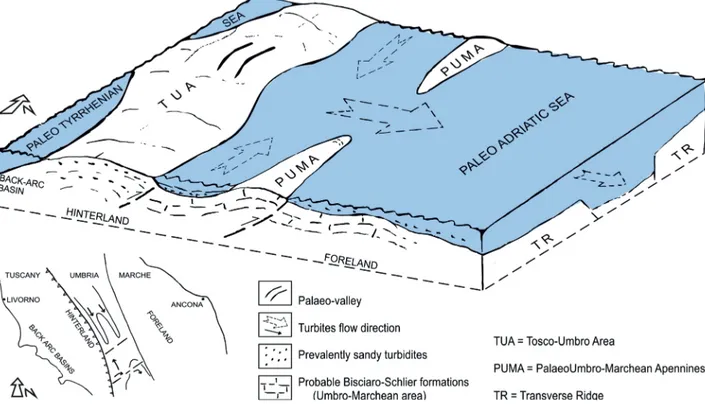
Associations of turbiditic and pelitic-sandstones (Messi-nian), outcrop between the two calcareous ridges and along the eastern flank of the Marchean ridge.
The Peri-Adriatic belt, more to the east, is instead characte-rized by pelitic and sandy-conglomeratic turbidites, belonging to the marine “Pliocene–Pleistocene sedimentary cycle” (Fig. 1) (Cantalamessa et al. 1986).
On a regional scale the structural setting is constituted by: • anticline folds involving Mesozoic–Miocene units; • syncline folds in the turbiditic sediments;
• east-verging monoclinalic structures involving the Peri-Adriatic turbidites.
This “schematic” structural setting is complicated by the presence of several east-verging thrusts which caused the overlapping of various levels of the sedimentary succession and the resulting genesis of the Umbria-Marche Apennine (Calamita & Deiana 1988; Mazzoli et al. 2005; Pierantoni et al. 2013). The genesis is associated with the intense Oligo-cene–Miocene compressive tectonics (active until the Plio-cene), in the outermost sector (Bally et al. 1986; Deiana & Pialli 1994; Calamita et al. 2012; Di Domenica et al. 2012) and to wide-ranging vertical movements, not related to the structural setting of bedrock (Dufaure et al. 1989; Dramis 1992). Normal faults with NW–SE trend, connected to a gene-ralized tectonic uplift and the associated extensional phase (with maximum during the early and mid-Pleistocene) (Demangeot 1965; Ambrosetti et al. 1982; Coltorti et al. 1991; Mazzoli et al. 2005) are mainly superimposed on the previous compressive structures: as a consequence, they generated, along the chain and its Tyrrhenian side, wide tectonic basins, tiered lowering of the relict surface, and tectonic-gravitational phenomena (Calamita et al. 1994; Gentili & Pambianchi 1994; Materazzi et al. 2014). Less frequent SSW–NNE faults, on the other hand, generated topographic “undulations” (Dramis et al. 1991) outlining three main transversal “ridges” (Fig. 2).
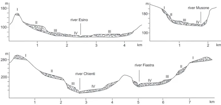
The physical landscape is therefore characterized by a strict conformity between the main geomorphological elements and the overall geological setting. In fact, structural “highs” corre-spond to morphological highs (i.e. reliefs with maximum ele-vation around 2500 m a.s.l.), while structural “lows” (i.e. tectonic basins) correspond to elongated depressions; the Peri-Adriatic monocline, incised by the main river valleys, corresponds to typical triangular hilly reliefs with the top facing west. On a larger scale such conformity is complicated by the aforementioned transversal “ridges” (which give rise to cliffs along the coast) and by scarps and benches along the valley floors created by the emplacement of four main orders of flu-vial terraces (Middle Pleistocene–Holocene) (Coltorti et al. 1991; Gentili & Pambianchi 1987; Nesci et al. 2012).
Results and discussion
Geological and geomorphological dataGeological data related to the Miocene–Pliocene tectonic and sedimentary evolution are fundamental for the reconstruc-tion of the evolureconstruc-tional stages of the continental landscape of central Italy (Centamore & Deiana 1986; Boccaletti et al. 1986; Centamore & Micarelli 1991; Cantalamessa & Di Celma 2004). During the Messinian the westernmost areas, Tuscany and Umbria, emerge progressively, according to a thrust belt mechanism (Fig. 3).
In the foredeep area, placed immediately to the east (Marche sector), the turbiditic sedimentation, occurred in narrow basins, elongated in a NW–SE direction.
During the Middle and Late Messinian, simultaneously with the “salinity crisis” of the Mediterranean (Cita 1976;
9 GEOMORPHOLOGICAL EVOLUTION OF THE ADRIATIC SIDE OF CENTRAL ITALY
Centamore & Deiana 1986; Wezel 1994; Butler et al. 1995), continental areas have grown at the edges of the primordial Tuscany-Umbria Apennines. The intense compressional tec-tonics, as well as producing a general seabed uplifting, locally created narrow and shallow basins and structural highs, bor-dered by NW–SE and SSW–NNE faults: the latter, affecting the morphology of the seabed (with the formation of subma-rine valleys), generated preferential pathways for turbiditic flows coming from the west. These flows filled the above mentioned basins, where coarse materials (arenaceous peb-bles) produced after the initial dismantling of the calcareous ridge were deposited. Contributions to such deposition also came from local fluvial sediments produced by the erosion of the Bisciaro and Schlier marly formations, which were out-cropping on the first emerged areas of the Umbria-Marche
ridge (Fig. 3). During this period continental erosion became particularly intense in relation to the intense compressional tectonics and to the humid climate conditions connected with the volcanic activity of the period (Centamore & Micarelli 1991; Wezel 1994).
The subsequent Plio–Pleistocene marine sedimentation is very complex and variable in time and space in relation to tec-tonic events that influenced morphology and sedimentation. At the beginning of the Pliocene the Apennine chain continued its progressively eastward structuring, forming the Umbria-Marche and Umbria-Marche ridges and the depression in between (Fig. 1).
In the northern sector, the depositional sequence within basins articulated by the synsedimentary tectonics, is given by clays, passing upwards to sandy turbidites. The “Val
Marecchia gravitational flow” (varicoloured clays, Ligurides) fills one of these basins; on the top fan-delta pebbles, coming from the flow itself and referring to end of the lower Pliocene/ beginning of the middle Pliocene time span and to a 500m-deep environment, are deposited. In other cases, the sequence top is characterized by conglomerates conveyed in the basin depres-sions and resulting from fan-delta deposit remobilization of the Po river domain (Veneri 1986). The sediments of the mid-dle-late Pliocene are mainly clayey and generally of limited extension.
Likewise, in the central sector, the Pliocene deposits have limited overall extension and exhibit clayey facies of a bathyal environment.
In the southern area (between the Tenna and Tesino rivers), arenaceous-conglomeratic beach deposits, related to the mid-dle Pliocene transgression, overlap the pelitic-arenaceous facies of the Laga formation (Messinian). This contact is marked by a sharp erosion surface that truncates the Messinian sediments and, more in detail, it is tilted eastward by 15–20° as a result of the aforementioned upper Pliocene compressive tectonics and the subsequent uplifting. This surface is still present and observable 10–12 km eastward of the Apennine ridge, where it is “protected” by the transgressive sediments. Originally it extended to the ridge, where it probably cut the Miocene sediments of the Umbria-Marche Succession (cur-rently absent at the top of the relief), and had a sub-horizontal trend: in fact, the strata of the overlying transgressive sedi-ments are approximately parallel to the surface itself; even the original extension to the west of these sediments would be much greater than today (Fig. 4) (Gentili et al. 1995).
The genesis of such stratigraphic discontinuities is to be associated with the intense Pliocene compressive tectonics (which completed the emergence of the Apennine chain and of the Messinian turbidites), and the concomitant arid-warm or subtropical-humid climatic conditions, both favourable to peneplanation processes (Denny 1967; Butzer 1976; Centamore & Deiana 1986). Marine erosion, significantly contributed to the genesis of this surface: this period, in fact, corresponds to the highest level reached by the sea between the Messinian and the Holocene, as a consequence of ice caps thawing (Cen-tamore & Deiana 1986; Haq et al. 1987; Bigi et al. 1995). Because no traces of mid-Pliocene sediments and surface ero-sion have been observed along the Apennine ridge it can be assumed that they have been “erased” during the subsequent phase of erosion.
The middle and upper Pliocene sedimentation continues with shelf-to-bathial clays, thicker eastward, with interspersed conglomeratic levels (submarine fans), mainly consisting of calcarenitic clasts; marly calcareous and arenaceous pebbles are in fact very rare (Cantalamessa et al. 1986; Centamore & Deiana 1986; Coltorti et al. 1991). Pebbly deposits of clearly fluvial origin, originated from the Apennines or, subordinately, from neighbouring ridges (“Montagna dei Fiori” and Gran Sasso massifs) and were transported within the basin through transversal channels already active in earlier times (Cantala-messa et al. 1986; Bigi et al. 1995; Gentili et al. 1998).
Areal differences also occur in marine Pleistocene sedi-ments. In the northern and central sectors the base of the early Pleistocene, is given by clays and sands deposited in a 500m- deep environment, on which Sicilian conglomeratic lenses are
11 GEOMORPHOLOGICAL EVOLUTION OF THE ADRIATIC SIDE OF CENTRAL ITALY
deposited in discordance. In the southern sector, on the con-trary, the Pleistocene succession is more powerful and conti-nuous and it starts with a pelitic complex containing numerous conglomeratic and sandy-conglomeratic bodies deposited in a shelf environment characterized by storm deposits (end of early Pleistocene). A marked erosional surface is present between these deposits and the mainly gravelly sediments of Sicilian age: moreover numerous evidences of synsedi-mentary extensional tectonics are found. Sicilian deposits,
currently present up to about 10 km from the Adriatic Sea, show eastern dip: this is due partly to depositional conditions (clinostratigraphy) and partly to the tilting connected with vertical uplifting and the compressive tectonics which are still active along the Adriatic coast (Riguzzi et al. 1989; Di Bucci et al. 2003).
The tectonic and sedimentary history above described is fundamental for the reconstruction of the continental land-scape; clastic contributions from the formations of the
Fig. 4. a — Transgressive sedimentary sequence and tectonic-sedimentary evolution of study area during the middle Pliocene; b — detail of
Umbria-Marche Apennines, are absent in the whole Peri- Adriatic belt, up to the base of the middle Pliocene. Later, during the middle Pliocene and mainly in the late Pliocene, the deposition of conglomeratic bodies mainly constituted by cal-careous pebbles occurred only in the southern Marche region. In this area, which is the most tectonically uplifted, and for the time span considered it can be assumed that erosion pro-cesses mainly involved the marly-calcarenitic units (Scaglia cinerea, Bisciaro, Schlier, Marne con Cerrogna and Marne a Pteropodi formations), that were still covering most of the Apennine ridges. The Pliocene sedimentation, in fact, in agreement with the lithological composition of the above mentioned units, is mostly constituted by a prevailing pelitic component, while the clastic deposits represent not more than 10 %. The volumes are also certainly comparable. The marly- calcarenitic units could provide about 4/5 of the middle-upper Pliocene sediments. The remaining fraction is attributable to contributions from erosion of the oldest units (“Scaglia” for-mations), by river valleys probably set on ancient turbiditic flowlines which can be associated with the reduced presence of marly-calcareous clasts within conglomeratic levels. The erosion of the Laga Formation, outcropping between the basin and the chain, is linked to the deposition of the arena-ceous bodies of the early middle Pliocene, of the sandy levels and of the rare arenaceous pebbles within the conglomeratic pebbles.
The early Pleistocene is marked by a strong marine regres-sion, similar to that of the middle Messinian and probably associa ted with the same arid-cold clima tic conditions (Denny 1967; Butzer 1976; Haq et al. 1987; Bull 1992). The associa-ted intense areal erosion processes produced: i) the removal of the westernmost transgressive sediments, the further dismant-ling of the Laga Formation below, down to the pre-eva poritic levels in the innermost areas; ii) the final dismantling of the marly-calcarenitic units and part of the “Scaglia” formations: in the Sibillini Mountains, but also in the most elevated areas
of the ridge, the erosion reached the base of the Scaglia rosata or, sometimes, the top of the Maiolica; iii) planation surfaces close to the tops of the highest hilly relief in the Peri-Adriatic belt, while further east, along the coast, marine sedimentation was ending (Gentili et al. 1998), (Fig. 5).
Continental landforms
When the tectonic-sedimentary evolution described above ended (Messinian–early Pleistocene), the fundamental mor-phostructural fea tures of the landscape were already realized.
Subsequently, the sub-aerial model ling processes, in
associa tion with the increasing tectonic activity, produced the re-shaping of the landscape. The oldest traces are placed at or near the top of the calcareous ridges and of the arena ceous reliefs of the Apennines and consist of residual limbs of an extensive wavy (locally flat) surface: the “summit relict sur-face”. Younger limbs of smaller extent and belonging to other two generations of surfaces are embedded in it: they also occur in the hilly area, where they are also placed at the top of the relief while in the coastal sector only the newer generation can be detected (Fig. 6).
All these surfaces constituted a low-relief landscape charac-terized by wide valleys, which later became home to important subaerial depositional processes. Looking at the pedemoun-tain areas in more detail, the deposition of wide alluvial fans took place, giving rise to a process of relief inversion with interfluves often very different from the current ones. The topo-graphical location of the different planation surfaces, placed at elevations higher than the alluvial deposits, allows us to date back to prior of the Middle Pleistocene the last phase of modelling of this landscape.
This “palaeotopography” was deformed by the tectonic uplift of the area and by the transversal tectonic elements (SSW–NNE faults) which have acted before, during and after the construction of the Apennine chain (Boccaletti et al. 1986;
13 GEOMORPHOLOGICAL EVOLUTION OF THE ADRIATIC SIDE OF CENTRAL ITALY
Calamita & Deiana 1988; Dramis et al. 1991; Calamita et al. 1999). During the Quaternary the tectonic elements, by means of differentiated vertical movements, created several trans-versal morphostructures, indicated by clear N–S undulations of the planation surfaces that are more accentuated in the older ones. Same undulations can also be recognized in the oldest alluvial deposits (early middle Pliocene) and in the Sicilian- Crotonian sediments which closed the Pliocene–Pleistocene cycle of deposition.
Three main SSW–NNE “ridges”, from the Apennine chain to the Adriatic Sea, can be recognized: Mount Nerone–Pesaro, to the north; Mount Penna–Cingoli–Mount Conero, in the centre; Sibillini Mountains–Mount Ascensione–Porto San Giorgio, to the south. The corresponding coastal sectors are characterized by substantial cliffs, two of them active (Pesaro and Mount Conero). The above “ridges” are separated by two “depres-sions” incised by the centripetal hydrographic networks of Misa and Nevola rivers in the central-northern sector and of Potenza and Chienti rivers in the central-southern sector (Fig. 2).
The effects produced by the SSW–NNE faults on the “sum-mit relict surface” located west of the culmination of the ridge, are more evident. Stepwise benches with considerable displacements (up to 1000 m) have been created: the same areas are characterized by the presence of wide tectonic basins (Colfiorito, Castelluccio, Norcia, Cascia), where the oldest deposits date back to the beginning of the early Pleistocene (Ficcarelli & Mazza 1990) (Fig. 7).
At the end of the Early Pliocene the “summit relict surface” was probably articulated in two levels: It is therefore reaso-nable to assume, for the end of the early Pleistocene, a “sum-mit relict surface “ on two levels: the higher one, nearly the top of the calcareous and marly-calcareous ridges of the Apen-nines, with N–S altitudinal variations (Dramis et al. 1991 and Dramis 1992); the lower one, carved in the marly-calcareous lithotypes where wide primordial valleys formed and corre-spond to the pre-evaporitic arenaceous facies of the Laga for-mation and of the Pliocene–Pleistocene deposits. According to Dramis (1992), despite the general prevalence of planation processes, the landscape could have been modelled, under favourable climate conditions, also by fluvial erosion.
The end of morphogenesis of the “summit relict surface” due to areal erosion processes, was associated with the intense tectonic uplift, which started at the end of the early Pleistocene and continued during the Middle Pleistocene. The consequent rapid deepening of the hydrographic network reached the oldest calcareous formations. The combined action of tectonic uplift and climate conditions favourable to areal erosion (Haq et al. 1987; Bull 1992), produced wide valleys, which have left evidence in the form of residual limbs of two generations of “surfaces” encasing each other.
Moreover, starting from the middle of the Middle Pleisto-cene, the interference between tectonic uplift and glacial and interglacial phases has also produced three main orders of flu-vial terraces attributed to the middle of the Middle Pleistocene,
Fig. 6. Block diagram showing the relationship among the different
end of Middle Pleistocene and Late Pleisto-cene respectively (Coltorti et al. 1991; Nesci & Savelli 1991; Cilla et al. 1996). The depo-sition of these fluvial terraces marks the final structuring of the landscape on a regional scale (Fig. 8).
A further generation of fluvial deposits (fourth order), mainly related to the intense slope dynamics, can be recognized along the valley floors: it is connected to intense agri-cultural practices on the slopes themselves carried out with alternate phases since Roman times. These processes have also had an impact on the river mouths (systemati-cally transformed from modest estuaries to limited deltas) and on the genesis of sandy- pebbly beaches (Gentili & Pambianchi 1987; Aringoli et al. 2007; Materazzi et al. 2010).
Conclusions
The data presented, allow us to draw syn-thetic conclusions, also shown in Figs 3, 9 and 10.
Fig. 7. Sketch of the development of tectonic
basins described in the text (modified after Calamita et al. 1982); a — relict surface; b — ini-tial phase of extensional tectonics (early Pleisto-cene); c — horst-graben morphology (middle Pleistocene); d — sketch of the tectonic basins and traces of cross-sections (see Fig. 2 for the location).
15 GEOMORPHOLOGICAL EVOLUTION OF THE ADRIATIC SIDE OF CENTRAL ITALY
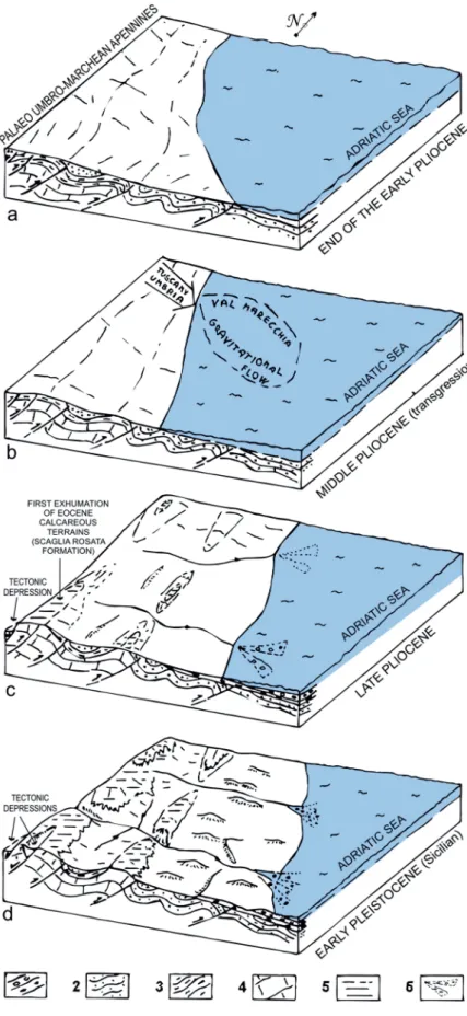
• The Middle and Late Messinian (Fig. 3) is characterized by the uplifting of the conti-nental areas of Tuscany and Umbria and the initial outcrop chain Umbria-Marche. • The end of the Early Pliocene (Fig. 9a) is
characterized by intense areal erosion pro-cesses which produced planation surfaces both in the Messinian and in the calcareous marls of the Apennine chain. It is recogni-zable only in the southern area, because it is buried by the middle Pliocene sediments (Fig. 4).
• During the Middle Pliocene (Fig. 9b) the marine transgression favoured the reduc-tion of continental areas while the planareduc-tion processes still affected the same lithotypes of the previous phase; in the northern sector the link between the Adriatic and Tuscan- Umbria areas persists.
• In the Late Pliocene (Fig. 9c) areal erosion reached calcareous and marly-calcareous formations even though their outcrops are limi ted. The beginning of the “summit relict surface” modelling can be ascribed to this period.
• In the Early Pleistocene (Fig. 9d), climate conditions favourable to areal erosion led to the final structuring of the “summit relict surface”. The tectonic uplift caused the deepe ning of the hydrographic network, isolating the relict surface itself and gene-rating secon dary “surfaces”. During this phase, waves and dislocations of the “sum-mit relict surface” and in particular the opening of intramountain tectonic basins occurred (Fig. 7).
• In the Middle-Late Pleistocene (Fig. 10) the persistent tectonic uplift and intense climate variations caused the definitive deepening of the hydrographic network and the genesis of several orders of fluvial terraces.
References
Amato A. & Cinque A. 1999: Erosional land sur-faces of the Campano-Lucano Apennines (S. Italy): genesis, evolution, and tectonic implica-tion. Tectonophysics 315, 251–267.
Ambrosetti P., Carraro F., Deiana G. & Dramis F. 1982: The uplift of central Italy between early Pleistocene and middle Pleistocene. Contributi conclusivi per la realizzazione della Carta Neotet-tonica d’Italia. Pubbl.n°513 del P.F. Geodinami-ca-CNR (in Italian).
Aringoli D., Gentili B. & Pambianchi G. 1996: The role of recent tectonics in controlling the
Fig. 9. Palaeogeographic reconstruction from the early Pliocene to early Pleistocene (not
in scale): 1 — clays, sands and conglomerates (Pliocene–Pleistocene); 2 — arenaceous, arenaceous-pelitic and pelitic-arenaceous turbidites (Messinian); 3 — calcarenitic marls (Middle Eocene–Messinian); 4 — limestones and marly limestones (Early Jurassic– Middle Eocene); 5 — areas with calcareous outcrops; 6 — alluvial fans.
deep-seated gravitational deformation of Mount Frascare (Cen-tral Apennine). Geogr. Fis. Dinam. Quat. 19, 281–286.
Aringoli D., Gentili B., Pambianchi G. & Piscitelli A.M. 2007: The contribution of “Sibilla appenninica” legend to karst knowledge in the Sibillini mountains (Central apennines, Italy). In: Piccardi L. & Masse W.B. (Eds.): Myth and Geology. Geol. Soc. London, Spec. Publ. 273, 329–340.
Aringoli D., Calista M., Gentili B., Pambianchi G. & Sciarra N. 2008: Geomorphological features and 3D modelling of Montelparo mass movement (Central Italy). Engineering Geology 99, 70–84. Aringoli D., Gentili B., Materazzi M., & Pambianchi G. 2010: Mass
movements in Adriatic central Italy: activation and evolutive control factors. In: Ernest D. Werner & Hugh P. Friedman (Eds.): Landslides: Causes, Types and Effects. Nova Science Publish-ers, Inc., New York, 1–71.
Aringoli D., Cavitolo P., Farabollini P., Galindo-Zaldivar J., Gentili B., Giano S.I., Lopez-Garrido A.C., Materazzi M., Nibbi L., Pedrera A., Pambianchi G., Ruano P., Ruiz-Constan A., Sanz de Galdeano C., Savelli D., Tondi E. & Troiani F. 2014: Morphotec-tonic characterization of the Quaternary intermontane basins in the Umbria-Marche Apennines (Italy). Rend. Fis. Acc. Lincei 25, Suppl. 2, 111–128.
Bally A.W., Burbi L., Cooper C. & Ghelardoni P. 1986: Balanced sec-tions and seismic reflecsec-tions profiles across the Central Apen-nines. Mem. Soc. Geol. Ital. 35, 257–310.
Bartolini C. 1980: About some summital surfaces of the northern Apennine. Geogr. Fis. Dinam. Quat. 3, 42–60 (in Italian). Bernini M., Clerici A., Papani G., & Sgavetti M. 1977: Analysis of the
plane-altimetric distribution of western Emilian Apennine paleo-surfaces. L’Ateneo Parmense, Acta Naturalia 13, 145–156 (in Italian).
Bigi, S., Cantalamessa, G., Centamore, E., Didaskalou, P., Dramis, F., Farabollini, P., Gentili, B., Invernizzi, C., Micarelli, A., Nisio, S., Pambianchi, G. & Potetti, M. 1995: The Marchean-Abruzzi peri-Adriatic belt from middle Pliocene to modern times: tectonic, sedimentary and geomorphological evolution. Studi Geol. Camerti. Vol. Spec. 1991/2, 21–26 (in Italian).
Boccaletti M., Calamita F., Centamore E., Deiana G. & Dramis F. 1983: The Umbria-Marche Apennine: an example of thrust and wrenching tectonics in a model of ensialic Neogenic-Quaternary deformation. Boll. Soc. Geol. Ital. 102, 581–592.
Boccaletti M., Calamita F., Centamore E., Chiocchini U., Deiana G., Moratti G., Micarelli A. & Potetti M. 1986: Evolution of the Tus-can-Umbro Apennine during Neogene. Giorn. Geol. 48, 227– 233 (in Italian).
Bosi c., Caiazzo C., Cinque A. & Messina P. 1996: Relict surfaces of the Fucens region, central Apennine and their significance in the reconstruction of the geological evolution. Il Quaternario 9, 381–386 (in Italian).
Brancaccio L., Cinque A., Romano P., Rosskopf C., Russo F., Santan-gelo N. & Santo A. 1991: Geomorphology and neotectonic evo-lution of a sector of the Tyrrenian flank of the souther Apennines (Region of Naples, Italy). Z. Geomorphol. Suppl. 82, 47–58. Bull, W.A. 1992: Geomorphic response to climatic change. John
Wiley & Sons, New York.
Butler R.W.H., Lickorish W.H., Grasso M., Pedley H.M. & Ramberti L. 1995: Tectonic and sequence stratigraphy in Messinian basin, Sicily: constraints on the initiation and termination of the Medi-terranean salinity crisis. GSA Bulletin 107, 425–439.
Butzer K.W. 1976: Geomorphology from the earth. Harper and Row, 1–463.
Calamita F. & Deiana G. 1988: The arcuate shape of the Umbria-Marche-Sabine Apennines (Central Italy). Tectonophysics 146, 131–147.
Calamita F., Coltorti M., Deiana G., Dramis F. & Pambianchi G. 1982: Neotectonic evolution and geomorphology of the Cascia and Norcia depressions (Umbria-Marche Apennine). Geogr. Fis. Dinam. Quat. 5, 263–276.
Calamita F., Coltorti M., Farabollini P. & Pizzi A. 1994: Quaternary normal faults in the Umbria-Marche Apennine ridge: proposal of a model of inversion tectonics. Studi Geol. Camerti vol. spec. 1994/1, 211–225 (in Italian).
Calamita F., Coltorti M., Pieruccini P. & Pizzi A. 1999: Structural evo-lution and plio-quaternary morphogenesis of the Umbria-Marche Apennine. Boll. Soc. Geol. Ital. 118, 125–139 (in Italian). Calamita F., Satolli S. & Turtù A. 2012: Analysis of thrusts shear
zones in curved shaped belts: Ddeformation mode and timing of the Olevano-Antrodoco-Sibillini thrust (Central-Northern Apen-nines of Italy). J. Struct. Geol. 44, 179–187.
Cantalamessa G. & Di Celma C. 2004: Sequence response to syndep-ositional regional uplift: insights from high-resolution sequence stratigraphy of late Early Pleistocene strata, Periadriatic Basin,
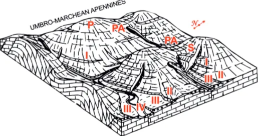
Fig. 10. Summary sketch of the relationships between different geomorphological elements: P = relict surface; PA = suspended palaeovalley;
S = planation surfaces below the “summit relict surface”; I = first order alluvial terrace (initial phase of Middle Pleistocene); II = second order alluvial terrace (end of Middle Pleistocene); III = third order alluvial terrace (Late Pleistocene); IV = fourth order alluvial terraces (Holocene).
17 GEOMORPHOLOGICAL EVOLUTION OF THE ADRIATIC SIDE OF CENTRAL ITALY
Central Italy. Sediment. Geol. 164, 283–309.
Cantalamessa G., Centamore E., Chiocchini U., Colalongo M.L., Micarelli A., Nanni T., Pasini G., Potetti M. & Ricci Lucchi F. con la collaborazione di Cristallini C. & Di Lorito L. 1986: The Pliocene–Pleistocene in the Marche region (Il Plio–Pleistocene delle Marche). Studi Geol. Camerti, vol. spec. “La Geologia delle Marche”, 61–81 (in Italian).
Cello G., Mazzoli S., Tondi E. & Turco E. 1997: Active tectonics in the Central Apennines and possible implications for seismic hazard analysis in peninsular Italy. Tectonophysics 272, 43–68. Centamore E., & Deiana G. 1986: The geology of the Marche region.
Studi Geol. Camerti, vol. spec., 1–145 (in Italian).
Centamore E. & Micarelli A. 1991: Stratigraphy. In: L’ambiente fisico delle Marche. S.EL.CA. Firenze, 5–58 (in Italian). Chiarini E., Messina P. & Papasodaro F. 1997: Plio–Quaternary
geo-logical and tectonic evolution of the high Salto valley – central Italy: first results deriving from the analysis of relict surfaces and continental deposits. Il Quaternario 10, 625–630 (in Italian with English abstract).
Ciccacci S., D’Alessandro L., Dramis F., Fredi P. & Pambianchi G. 1985: Geomorphological and neotectonic evolution of the Umbria-Marche Ridge, northern sector. Studi Geol. Camerti 10, 7–15.
Cilla G., Coltorti M., Farabollini P., Dramis F., Gentili B., & Pambi-anchi 1996: Fluvial sedimentation during the early Holocene in the Marchean valleys (central Italy). Il Quaternario, Ital. J. Quat. Sci. 9, 2, 459–464.
Cita M.B. 1976: The geodynamic significance of the miocenic sali-nity crisis in the Mediterranean. In: Show and Tell Messinian Seminar, 2, 91 (in Italian).
Coltorti M. & Farabollini P. 1995: Quaternary evolution of the Castel-luccio di Norcia basin (Umbro-Marchean Apennine, Italy). Il Quaternario 8, 1, 149–166.
Coltorti M. & Pieruccini P. 2000: A Late Lower Pliocene planation surface across the Italian Peninsula: a key tool in neotectonics studies. J. Geodyn. 29, 323–328.
Coltorti M., Consoli M., Dramis F., Gentili B. & Pambianchi G. 1991: Geomorphological evolution of the central-southern Marche alluvial plains. Geogr. Fis. Dinam. Quat. 14, I, 87–100 (in Italian with English abstract).
Coltorti M., Farabollini P., Gentili B. & Pambianchi G. 1996: Geo-morphological evidences for anti-Apennines faults in the Umbro-Marchean Apennines and in the peri-Adriatic basin, Italy. Geomorphology 15, 33–45.
Deiana G. & Pialli G. 1994: The structural provinces of the Umbro-Marchean Apennines. Mem. Soc. Geol. It. 48, 473–484. Della Seta M., Del Monte M., Fredi P., Miccadei E., Nesci O., Pambi-anchi G., Piacentini T. & Troiani F. 2008: Morphotectonic evolu-tion of the Adriatic piedmont of the Apennines: An advancement in the knowledge of the Marche-Abruzzo border area. Geomor-phology 102, 119–129.
Demangeot J. 1965: Géomorphologie des Abruzzes adriatiques. Col-lection Mémoires et Documents. Editions, Paris, 1–403. Denny C.S. 1967: Fans and pediments. Am. J. Science 265, 81–105. Di Bucci D., Mazzoli S., Nesci O., Savelli, D., Tramontana, M., De
Donatis, M. & Borraccini F. 2003: Active deformation in the frontal part of the Northern Apennines:insights from the lower Metauro River basin area (northern Marche, Italy) and adjacent Adriatic off-shore. J. Geodyn. 36, 213–238.
Di Domenica A., Turtu’ A., Satolli S. & Calamita F. 2012: Relation-ship between thrusts and normal faults in curved belts: New insight in the inversion tectonics of the Central-Northern Apen-nine (Italy). J. Struct. Geol. 30, 1–14.
Dramis F. 1992: The role of wide-range tectonic uplift in the genesis of the Apennine ridge. Studi Geol. Camerti, Vol. Spec. 1992/1, 9–15 (in Italian).
Dramis F., Pambianchi G., Nesci O. & Consoli M. 1991: The role of transversal structural elements in the tectonic, sedimentary and geomorphological evolution of the Marche region. Studi Geol. Camerti Vol. Spec. 1991/2, CROP 11, 287–293 (in Italian). Dramis F., Gentili B. & Pambianchi G. 1992: The morphostructural
depresion of Macerata (La depressione morfostrutturale di Mace rata). Studi Geol. Camerti Vol. Spec.1993, 123–126 (in Italian).
Dramis F., Farabollini P., Gentili B. & Pambianchi G. 1995: Neotec-tonic and large-scale gravitational phenomena in the Umbria-Marche Apennines, Italy. In: Slaymaker O. (Ed.): Steepland Geomorfology. John Wiley & Sons Ltd., 199–217.
Dufaure J.J., Bossoyt D. & Rasse M. 1989: Critères géomor-phologiques de néotectonique verticale dans l’Appennin central adriatique. Bull. Afeq. 3, 151–160.
Fanucci F., Moretti E., Nesci O., Savelli D. & Veneri F. 1996: Typo-logy of alluvial terraces and relief evolution in the Adriatic side of central-northern Apennine Italy. Il Quaternario 9, 1, 255–258 (in Italian).
Ficcarelli G. & Mazza P. 1990: New fossil findings from the Col-fiorito basin (Umbria-Marchean Apennine). Boll. Soc. Geol. Ital. 29, 2, 245–247.
Gentili B. & Pambianchi G. 1987: Fluvial morphogenesis and anthropic activity in the central-southern Marche. Geogr. Fis. Dinam. Quat. 10, 204–217 (in Italian with English abstract). Gentili B. & Pambianchi G. 1994: Gravitational morphogenesis of the
Apennine chain in Central Italy. Proc. 7th Int. IAEG Congr., Sept. 1994, Lisboa (Portugal), vol. II, 1177–1186.
Gentili B. & Pambianchi G. 1999: Contribution to the reconstruction of the geomorphological evolution of the Adriatic side of the Umbria-Marche Apennine – central Italy. In: Orombelli G. (Ed.) : Geographical and geological study in honor of Severino Bel-loni. Glauco Brigati, Genova, 391–403 (in Italian).
Gentili B., Pambianchi G., Aringoli D., Cilla G., Farabollini P. & Mat-erazzi M. 1995: Relationship between Plio-Quaternary brittle deformations and gravitational morphogenesis in the high-hilly belt of the central-southern Marche. Studi Geol. Camerti, Vol. Spec. 1, 421–435 (in Italian with English abstract).
Gentili B., Materazzi M., Pambianchi G. & Scalella G. (in collabora-tion with Aringoli D., Cilla G. & Farabollini P.) 1998: Slope deposits at Mount Ascensione – southern Marche, Italy. Geogr. Fis. Dinam. Quat. 21, 1–10 (in Italian witht English abstract). Haq B.U., Hardenbol J. & Vail P.R. 1987: Chronology of fluctuating
sea levels since the Triassic. Science 235, 1156–1166.
Materazzi M., Gentili B., Aringoli D., Farabollini P. & Pambianchi G. 2010: Elements of slope and fluvial dynamics as evidence of Late Holocene climatic fluctuations in the central Adriatic sec-tor, Italy. Geogr. Fis. Dinam. Quat. 33, 193–204.
Materazzi M., Aringoli D., Pambianchi G., Gentili B. & Giacopetti M. 2014: Deep seated gravitational slope deformations and large landslides interferring with fluvial dynamics; examples from central Apennines (Italy). In: G. Lollino et al. (Eds.): Engineer-ing Geology for Society and Territory – Vol. 2. SprEngineer-inger Interna-tional Publishing Switzerland, 198–203.
Mazzoli S., Pierantoni P.P., Borraccini C., Paltrinieri W., & Deiana G. 2005: Geometry, segmentation pattern and displacement varia-tions along a major Apennine thrust zone, Central Italy. J. Struct. Geol. 27, 1940–1953.
Nesci O. & Savelli D. 1991: Terraced alluvial successions in the northern Apennine. Geogr. Fis. Dinam. Quat. 14, 149–162 (in Italian with English abstract).
Nesci O., Savelli D. & Veneri F. 1992: Alluvial terraces and planation surfaces in the relief evolution of the northern Apennine . Studi Geol. Camerti. Vol. Spec. 1992/1, 175–180 (in Italian). Nesci, O., Savelli, D., Tramontana, M., Veneri, F., De Donatis, M. &
Umbria-Marche-Romagna Apennines (Italy). Boll. Soc. Geol. Ital. 1, 915–922.
Nesci O., Savelli D. & Troiani F. 2012: Types and development of stream terraces in the Marche Apennines (central Italy): a review and remarks on recent appraisals. Géomorphologie 2, 215–238. Pierantoni P.P., Deiana G. & Galdenzi S. 2013: Stratigraphic and
structural features of the Sibillini Mountains (Umbria-Marche Apennines, Italy). Ital. J. Geosci. 132, 3, 497–520.
Riguzzi F., Tertulliani A.Z. & Gasparini C. 1989: Study of seismic sequence of Porto San Giorgio (Marche) – 3 July 1987. Il Nuovo Cimento della Soc. Ital. di Fisica 12, 4.
Schiattarella M., Di Leo P., Beneduce P. & Giano SI 2003: Quaternary uplift vs tectonic loading: a case-study from the Lucanian
Apen-nine, southern Italy. Quat. Int. 101/102, 293–251.
Sestini A. 1981: An ancient erosion surface on the Chianti Mountains. Rivista Geografica Italiana 88, 214–220 (in Italian).
Veneri F. 1986: The Valmarecchia gravitational flow. In: Centamore and Deiana, 1986: La geologia delle Marche, Studi Geol. Camerti vol. spec., 83–87 (in Italian with English abstract).
Veneri F., Nesci O. & Colantoni P. 1991: Reporting of continental deposits in correspondence of limbs of ancient surfaces in the northern Marche. Geogr. Fis. Dinam. Quat. 14, 247–250 (in Ita-lian with English abstract).
Wezel F.C. 1994: From black to red: within the heartbeat of the earth. Sperling & Kupfer, Milano, 1–315 (in Italian).