Alma Mater Studiorum – Univeristà di Bologna
DOTTORATO DI RICERCA IN SCIENZE
DELLA TERRA, DELLA VITA E DELL’AMBIENTE
Ciclo XXIX
Settore Concorsuale di afferenza: 04/A2
Settore Scientifico disciplinare: GEO/02
Continental sequence stratigraphy:
the Quaternary succession of the Po Basin (Italy) and its
relation to coeval coastal deposits
Presentata da: Agnese Morelli
Coordinatore Dottorato:
Relatore:
Barbara Mantovani
Alessandro Amorosi
1
INDEX
1. INTRODUCTION p. 4
2. THE PO BASIN: GEOLOGICAL SETTING p. 9
2.1 Tectonic setting p. 9
2.2 Stratigraphic architecture p. 12
3. DATABASE AND METHODS p. 20
3.1 Geologic database p. 21
3.2 Petrel data processing p. 26
4. MANUSCRIPT SUMMARY p. 29 4.1 Manuscript 1 p. 30 4.2 Manuscript 2 p. 30 4.3 Manuscript 3 p. 31 4.4 Manuscript 4 p. 31 4.5 Manuscript 5 p. 32 5. MANUSCRIPTS p. 34 5.1 Manuscript 1: p. 34
The value of pocket penetration tests for the high-resolution palaeosol stratigraphy of late Quaternary deposits
2
5.2 Manuscript 2: p. 59 Paleosols and associated channel-belt sand bodies from a
continuously subsiding late Quaternary system (Po Basin, Italy): New insights into continental sequence stratigraphy.
Amorosi A., Bruno L., Cleveland D.M., Morelli A., Hong W.
5.3 Manuscript 3: p. 97
Reconstructing Last Glacial Maximum and Younger Dryas paleolandscapes through subsurface paleosol stratigraphy: an example from the Po Basin, Italy.
Morelli A., Bruno L., Cleveland D.M., Drexler T.M., Amorosi, A.
5.4 Manuscript 4: p. 123
Global sea-level control on local parasequence architecture from the Holocene record of the Po plain, Italy.
Amorosi A., Bruno L., Campo B., Morelli A., Rossi V., Scarponi D., Hong W., Bohacs K.M., Drexler T.M.
5.5 Manuscript 5: p. 156
Po Plain, Last Glacial Maximum depositional sequence, Upper Pleistocene to Holocene, Italy.
Campo B., Morelli A., Amorosi a., Bruno L., Scarponi D., Rossi V., Bohacs K.M., Drexler T.M.
6. CONCLUSIONS p. 225
4
1. INTRODUCTION
During the last decades, the scientific community has developed a great interest towards alluvial and coastal depositional systems and the way they respond to climate and eustatic changes, with the aim of developing models able to predict the sedimentary response of depositional environments to future climate change (Demarest and Kraft, 1987; Nummedal and Swift, 1987; Saito, 1994; Morton and Suter, 1996;Marcucci, 2000; Bender et al., 2005). The temporal resolution of the ancient record is, however, insufficiently resolved to fully explain the complex relationship that are established under changing sea-level and climate conditions.
Late Quaternary successions provide a fundamental basis for high-resolution sequence-statigraphic analysis, for a number of reasons: eustatic fluctuations for the Late Pleistocene-Holocene period are well established; the influence of other factors on sedimentation is more easily detected than in older successions; a generally scarce degree of tectonic deformation is associated with Quaternary deposits; and radiocarbon dating, although restricted to the last 40-45 ky, may enable the creation of a reliable chronostratigraphic framework.
The Po Plain, a 46,000 km2 alluvial plain of northern Italy, represents a promising area for this kind of studies, as it has been extensively studied during the last 20 years for hydrocarbon and water research (AGIP Mineraria, 1959; AGIP, 1977; Aquater-ENEL, 1981), structural studies (Pieri and Groppi, 1975; Ori, 1993; Regione Emilia-Romagna and ENI-AGIP, 1998; Amorosi et al., 1999; Regione Lombardia and ENI Divisione AGIP, 2002; Amorosi, 2008), and for stratigraphic and sedimentological analysis (Amorosi et al., 1996; 1999; 2003; 2008a; 2008b; Amorosi and Colalongo, 2005).
The integration of seismic profiles and cored boreholes, with geochemical (Amorosi, 2012), mineralogical (Amorosi et al., 2002), petrographic (Marchesini et al., 2000), paleontological (Amorosi et al., 1999; 2003; 2004; Fiorini, 2004), and pollen (Amorosi et al., 2004; 2008; Amorosi, 2008) analyses has led the construction of the well-known Po Basin stratigraphic architecture. In particular, the late Quaternary depositional succession of the Po Plain includes a cyclic alternation of glacial and interglacial deposits (Amorosi et al., 2004; 2008a) that follow the Milankovitch theory of climate change (Hayes et al., 1976; Imbrie and Imbrie, 1979), firstly proved by studies on oxygen-isotope records in deep-sea sediments (Shackleton and Opdyke, 1973; Chappell and Shackleton, 1986).
The Milankovitch theory predicts global variation of ice volumes and sea-level following periods of 400, 100, 43, 23 and 19 ky, with a predominant 100 ky cyclicity for the Middle and Late Pleistocene. Additional work on the marine record led to the identification of smaller-scale cyclicity
5
(103-104) superposed on the 100 ky one (Behl and Kennet, 1996; Bond et al., 1993). These glacial to interglacial periodic changes were recorded by the stratigraphic succession from the Po Plain as cyclic variations in lithofacies and stacking patterns.
Recent studies (Amorosi et al., 1999b; 2004; Amorosi and Colalongo, 2005; Amorosi et al., 2008a) have described this cyclicity in the Po Basin from the proximal Apennine margin to the distal coastal plain succession. A glacio-eustatic control on sedimentary architecture is documented by the presence of eight, 4th order transgressive-regressive (T-R) cycles assigned to the last ca. 800 ky.
These sequences are represented, in distal areas, by aggrading coastal plain deposits with overlying, marine-influenced (brackish to shallow-marine) facies with a retrogradational trend, indicating the landward migration of depositional environments in response to sea-level rise, typical of the interglacial transgressive systems tract (TST). The sedimentary succession presents the upward transition from shallow-marine to coastal, brackish and alluvial deposits, representing the progradation of newly-formed delta lobes and strandplains, representative of the highstand systems tract (HST). The T-R cycle continues with a thick (up to 60 m), alluvial succession that accumulated under glacial conditions, during prolonged phases of sea-level fall (falling-stage, FSST, and lowstand systems tracts, LST).
In proximal areas, T-R cycles are characterized by deposits poorly affected by sea-level variations, with no evident lithofacies change, but where variations in the stacking pattern of fluvial-channel bodies are registered. The TST is characterized by silt-clay overbank deposits with isolated, lenticular fluvial-channel sands, while more amalgamated and laterally extensive bodies are encountered towards the HST, FSST and LST. Proximal and distal sectors have been correlated by Amorosi and Colalongo (2005) using the transgressive surfaces (TSs), which can be traced basin-wide owing to their characteristic warm-temperature pollen signature and the abrupt landward facies shift recorded in coastal areas. Recently, Amorosi et al. (2017) have shown that TSs in the more landward sectors are represented by pedogenized horizons, i.e. paleosols, the most recent of which marks the Pleistocene-Holocene transition and a parallel change in the alluvial stacking-patterns (Campo et al., 2016).
Paleosols can be read as regional stratigraphic markers in alluvial plain deposits, where they represent a powerful tool to subdivide monotonous alluvial clay-rich succession (Bown and Kraus, 1987; Wright and Marriott, 1993; Kraus, 1999; Trendell et al., 2012). Paleosols have been commonly used as a mapping tool in pre-Quaternary successions, while in the Quaternary record they have been studied for decades within the field of pedostratigraphy (Morrison, 1976; Kemp et al., 1995; Bestland, 1997; Eppes et al., 2008), to reconstruct pedosedimentary processes and analyze
6
the extent to which paleosol characteristics and micromorphologies change with climate or landscape evolution (Mahaney et al., 1993; Kraus, 1999; Feng and Wang, 2005; Ufnar et al., 2005; Sheldon and Tabor, 2009).
Recent studies (Wallinga et al., 2004; Srivastava et al., 2010; Amorosi et al., 2014; 2016; Tsatskin et al., 2015) have started considering the importance of Quaternary paleosols not only for pedostratigraphic analysis, but also as stratigraphic tools for correlating alluvial deposits. Particularly, Amorosi et al. (2014) described for the first time the presence of a set of weakly-developed paleosols in the subsurface of Bologna, but their lateral traceability has never been tested throughout the entire basin.
Paleosol stratigraphy represents a powerful tool for the stratigraphic interpretation of non-marine alluvial succession. It is, thus, important to increase the available dataset for paleosol correlations. The first part of this Ph.D. thesis focused, therefore, on developing a low-cost geotechnical technique that led us to the identification of pedogenized horizons even from poor-quality field log descriptions of the available database. We proceeded then with the high-resolution stratigraphic reconstruction of paleosol geometry, from the Apennine margin to the Po River. The stratigraphic relationships between pedogenized horizons and coeval thick, amalgamated Po fluvial-channel bodies were also analyzed. This is an important target for the oil industry, which sees fluvial amalgamated sand bodies as possible reservoirs. The next step was the reconstruction of the three-dimensional paleotopography at the time of major paleosol-formation events. Using the software package Petrel, we modelled the paleosol-bearing interfluves topography and the base of the related sand fluvial-channel bodies.
In the distal sector of the Po Plain, the Holocene succession is characterized by remarkable facies variability. There is an extensive literature detailing the depositional response of Holocene coastal systems to relative fluctuations of sea level developed on sub-Milankovitch cyclicity, i.e. millennial- to sub-millennial time scales (Lowrie and Hamiter, 1995; Somoza et al., 1998; Saito et al., 1998; Morton et al., 1999; Hori et al., 2002; Tanabe et al., 2003; 2006; Leorri et al., 2006; Hori and Saito, 2007; Amorosi et al., 2009; 2013; Poulter et al., 2009; Törnqvist and Hijma, 2012; Milli et al., 2016). However in most cases, with few exceptions (Tanabe et al., 2015), stratigraphic correlations are carried out with relatively poor chronologic control, and the internal configuration of millennial-scale sediment packages has been predominantly conceptualized and significantly oversimplified rather than documented. As a result, only limited information can be inferred about the factors (allogenic versus autogenic) that might have controlled facies architecture.
The second part of this Ph.D. thesis focused on the Holocene depositional history of the Po coastal plain south of the Po River. We examined millennial-scale parasequences, tracing their
7
boundaries several tens of kilometers along dip and strike; assessing the change in the driving factors (allogenic vs autogenic) during the last 10 ky; providing insight into the interpretation and prediction of sediment/rock packages with similar stratal architecture, but for which accumulation rates and the role of all possible causative mechanisms are poorly established or unknown; highlighting how the use of the sequence-stratigraphic approach enables one to decipher depositional history and play-element occurrence.
This three-year research project is the result of the collaboration between University of Bologna and:
• ExxonMobil Upstream Research Company, which supported the project through drilling of 20 continuously cored boreholes and providing the 3D software package Petrel (courtesy of Schlumberger);
• the Geological, Seismic and Soil Survey of Regione Emilia-Romagna which made available its database with more than 2,000 data including stratigraphic descriptions from continuously drilled cores and water-well logs, cone penetration tests, radiocarbon dating, pollen profiles and geotechnical data;
• KIGAM laboratory (Republic of Korea), where 150 radiocarbon dates from organic matter-rich samples and shells were carried out.
9
2. THE PO BASIN: GEOLOGICAL SETTING
2.1 Tectonic setting
The Po Plain is one of the largest alluvial plain in Europe. It represents 15% of the Italian peninsula with its 46,000 km2. The Po River subdivides the Po Plain in two areas: to the North it is characterized by coarser and more sandy-rich deposits, while to the South a finer and more clay-rich stratigraphy is presented (Astori et al., 2002).
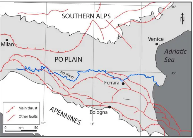
Water and oil geophysical research from the Seventies led to the first structural subsoil reconstructions (AGIP Mineraria, 1959; AGIP, 1977; Aquater, 1976; 1977; 1978; 1980; Aquater-ENEL, 1981). These first works, mainly based on seismic profiles interpretation, were followed by detailed studies with different purposes, highlighting the Po Basin structural characteristics (Pieri and Groppi, 1975; Bartolini et al., 1982; Cremonini and Ricci Lucchi, 1982; Castellarin et al., 1985; Boccaletti et al., 1987; Castaldini and Panizza, 1991; Doglioni, 1993; Regione Emilia-Romagna and ENI-AGIP, 1998; Amorosi et al., 1999; Regione Lombardia and ENI Divisione AGIP, 2002; Amorosi and Colalongo, 2005; Molinari et al., 2007; Amorosi, 2008). Summarizing these works, the Po Plain can be described as the superficial expression of a rapidly subsiding foreland basin, the Po Basin, bounded by the S-verging Alpine fold-and-thrust belt to the North, and by the N-NE verging Apennines to the South (Fig. 1).
The evolution of these two mountain chains took place during the Eurasia-Africa convergence since the Cretaceous (Carminati and Doglioni, 2012), showing an ongoing motion of 3-8 mm/y (Serpelloni et al., 2007). The northern limit of the Po Basin is represented by the Southern Alps, with an extension of 700 km, related to the Apulian-Adriatic margin deformation (Kearey and Vine, 1990). The Southern Alps are a post-collisional mountain chain connected to the southward subduction of the European plate underneath the Adriatic plate (Vannoli et al., 2015). It is characterized by a S-verging fold-and-thrust belt where non-metamorphosed Permo-Mesozoic and Tertiary deposits have been folded in various phases from the Eocene to the Plio-Quaternary (Castellarin, 2001).
10
The southern margin of the Po Basin is represented by the buried Apenninic northern margin (AGIP, 1977; Boccaletti et al., 1985; Castellarin et al., 1992; Argnani et al., 2003) . The Apennines formation is related to the WSW-dipping subduction of the Adria plate beneath the European crust, which started during the Oligocene after the post-collisional phase of the Alpine orogenesis (Vai and Martini, 2001). The Apennine thrust fronts, foredeep basins and extensional back arcs migrated progressively to the East as a consequence of the radial retreat of the subduction process (Doglioni et al., 1999), as confirmed by deep tomographic profiles (Castellarin et al., 1994).
Fig. 1. Simplified structural map of the Po Basin. Modified from Burrato et al. (2003).
The N-verging fold-and-thrust belt Apenninic structure (Fig. 2) involves Mesozoic to Neogene deposits of Adria and older basement (Picotti and Pazzaglia, 2008). After a series of deep seismic profiles and boreholes carried out by Agip, its buried structure beneath the Po Plain was identified (Pieri and Groppi, 1981). Three main folded arcs were recognized (Fig. 3), from the West to the East: the Monferrato arc, the Emilia arc and the Ferrara-Romagna arc. The latter is furthermore subdivided into Ferrara, Romagna and Adriatic folds, the latter buried in the Adriatic offshore covered by Late Pleistocene and Holocene deposits (Mazzoli et al., 2015). These arcs are characterized, in the western portion, by W-verging fold-and-thrusts, while to the East they are composed by en-echelon folds and NE-verging high-angle reverse faults (Costa, 2003).
11
Fig. 2. Fold-and-thrust belt buried structures beneath the Po Plain. Modified from Picotti and Pazzaglia (2008).
The southern portion of the Po Basin presents a sedimentary Pliocene-Quaternary filling, up to 8000 m thick (Pieri and Groppi, 1981). Their apparently non-deformed geometry firstly led to the wrong assumption that these folds and thrusts were inactive. The activity of the thrusts has been recently proved, following geomorphological and geophysical studies (Burrato et al., 2003; Carminati and Vadacca, 2010), and after the recent reactivation of the external thrusts (Ferrara arc and Mirandola anticline) that led to the M 6.0 2012 earthquake (Caputo et al., 2012).
Fig. 3. The buried Apenninic outer fronts. From Costa (2003).
The Po Basin presents a high subsidence rate related to the crustal flexuring generated by the Apennines growth (Carminati et al., 2005), with long-term subsidence rates between 0.4 and 2.4 mm/y, where the highest values are registered in the modern Po delta (Antonioli et al., 2009).
12
Present-day rates are more related to the anthropogenic component, including water pumping and hydrocarbon extraction in the coastal areas that led to a maximum of 70 mm/y (Baldi et al., 2009), while the natural ones are still affected by the effect of the post-Last Glacial Maximum deglaciation (Carminati et al., 2005).
2.2 Stratigraphic architecture
The subsurface geology of the Po Basin fill has been largely investigated with the aid of the interpretation of seismic data for hydrocarbon exploration (Pieri and Groppi, 1981). The general trend is a “regressive” evolution from an open-marine Pliocene sedimentation to Quaternary shallow-marine and continental deposits.
Additional studies based on seismic profiles and stratigraphic cross-sections (Regione Emilia-Romagna and ENI-AGIP, 1998; Regione Lombardia and ENI-Divisione AGIP, 2002) revealed a progressive decrease in the degree of tectonic deformation from base to top (Fig. 4).
Fig. 4. Seismic profile interpretation between Bologna and Ferrara: Plio-Quaternary Po Basin fill subdivision into six depositional sequences. From Regione Emilia-Romagna & Eni-Agip (1998).
These studies led to the subdivision of the Plio-Quaternary succession into unconformity-bounded stratigraphic units (UBSU), each indicating a phase of significant basin geometry modification. Four main Quaternary unconformities (Fig. 5) were used for the stratigraphic subdivision of the Po Basin succession in depositional sequences, representing important phases in the basin evolution history:
13
• 1.6 Ma BP unconformity (blue line of Fig. 5), linked to a regional tectonic uplifting event in the southern part of the Po Basin, which resulted in the shifting of the sedimentation towards the basin center;
• 1.24 Ma unconformity (green line of Fig. 5), mainly caused by tectonic activity;
• 0.87 Ma unconformity (red line of Fig. 5, the “Red Surface” of Muttoni et al., 2003, coinciding with the G surface of Fig. 4), linked to an important climatic event (onset of a dry and cold period), coincident with a glacio-eustatic lowstand (Muttoni et al., 2003; Pini et al., 2004). According to these authors, in seismic profiles the Red Surface does not appear to have tectonic origin, as it is not associated with angular unconformities;
• 0.45 Ma unconformity (yellow line of Fig. 5), probably caused by a minor uplifting event of the compressive Apenninic structures (Regione Lombardia and ENI-Divisione AGIP, 2002).
Fig. 5. Subsurface stratigraphy of the upper Po Basin fill. The yellow line corresponds to the “F” unconformity of Fig. 4, and the red one to the “E” unconformity. From Regione Lombardia and ENI-Divisione AGIP (2002).
14
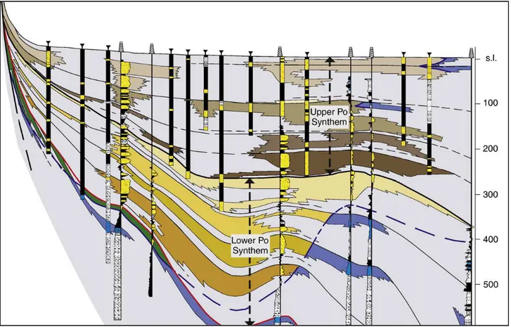
The post-0.87 Ma Quaternary succession represents the Po Supersynthem of Amorosi et al. (2008a) (Fig. 6). The unit thickness shows a maximum of 800 m underneath the modern alluvial plain, whereas it thins towards the basin margins, i.e. toward the Apennines and the Alps (Fig. 6). The Po Supersynthem lower limit (red lines in Figs. 5-6, G surface of Fig. 4) is an important unconformity mapped throughout the whole basin (Regione Emilia-Romagna and ENI-AGIP, 1998; Regione Lombardia and ENI-Divisione AGIP, 2002). The identification of a lower-rank regional unconformity (0.45 Ma unconformity) within the Po Supersynthem led to its subdivision into Upper and Lower Po Synthems (Fig. 6). Each synthem was furthermore partitioned in four subunits (subsynthems), defining four different aquifers, each one with a mean thickness of a few tens of meters, thickness that may locally change due to tectonic activity.
Fig. 6. Po Supersynthem subdivided into Lower and Upper Po Synthem by the ca. 0.45 Ma unconformity (from Amorosi et al., 2008).
Despite poor chronologic control, the presence of 8 cycles, representing 8 aquifers, bounded by an unconformity dated 870 ky linked to the first great Pleistocene alpine glaciation (Muttoni et al., 2003), suggests a mean duration of 100 ky for each cycle. High-resolution stratigraphic and pollen analyses by Amorosi et al. (2008a) from the Upper Po Synthem depositional sequence support this
15
hypothesis, suggesting that this recurring facies alternation could be linked to the Milankovich-scale (100 ky) cyclicity. Each depositional cycle is characterized by a recurring alternation of coastal and alluvial deposits (Amorosi et al., 2003; 2004; 2005; 2008a; 2008b): near the basin margin the stratigraphic architecture is dominated by gravelly amalgamated alluvial fan bodies, with lateral transition to alternating gravelly/sandy fluvial channels and muddy overbank deposits (Ori, 1993; Amorosi et al., 1996). Distal areas are, instead, characterized by an alternation of coastal and alluvial deposits in Transgressive-Regressive (T-R) sequences (Amorosi, 2008). These T-R cycles represent the sedimentary response to 4th order sea-level fluctuations linked to the Milankovitch cyclicity.
The youngest T-R cycle has been extensively studied over the last decades (Rizzini, 1974; Bondesan et al., 1995; Amorosi et al., 1999a; 2003). This cycle shows a Holocene succession, a few meters thick, separated from the underlying Last Glacial Maximum alluvial deposits by a subaerial unconformity surface. This surface is characterized by a hardened and locally pedogenized horizon that was firstly identified in the Venetian subsurface by McClennen et al. (1997), and later recognized by Amorosi et al. (1999a) in the Ravenna area. The sequence-stratigraphic interpretation of the 4th order depositional sequences reflects the classic subdivision in systems tract:
• The lower unit is composed by a thick alluvial succession that accumulated between 125,000 and 20,000 years BP, during the long phase of sea-level drop, i.e. falling-stage systems tract (FST), and the subsequent lowstand systems tract (LST). These systems tracts are characterized by channel incision and paleosol development in the interfluves;
• The following unit corresponds to the lower transgressive portion of the Holocene transgressive-regressive sequence, showing an increase in accommodation space and a landward migration of depositional environments, from purely marine to brackish and freshwater ones, as a result of rising sea level (transgressive systems tract, TST). In modern coastal plains, the first TST sedimentation is commonly lacking, generating an important hiatus that divides LST from the overlying TST, including the Pleistocene-Holocene boundary. The lower TST is commonly registered only within incised-valley fill (Posamentier and Allen, 1999);
• The upper unit records delta lobe and strandplain progradation, which characterizes the following highstand systems tract (HST), when fluvial processes are intensified in response to the lowering of sea-level rise (Stanley and Warne, 1994).
During the sea-level drop and lowstand phases, proximal areas are characterized by the deposition of thick, sand fluvial bodies with seaward migration of alluvial systems and an increase
16
in erosion (Amorosi and Colalongo, 2005). The rapid sea-level rise and the following highstand are instead dominated by fine-grained alluvial sedimentation, representing the landward equivalent of transgressive-regressive coastal successions (Fig. 7).
The depositional architecture of the Po Basin shows high resemblance with coeval deltaic and coastal successions described for the last 4th-order cycle around the world (Oomkens, 1970; Suter et al., 1987; Demarest and Kraft, 1987; Stanley and Warne, 1994; Gensous and Tesson, 1996; Morton and Suter, 1996; Yoo and Park, 2000, Amorosi and Milli, 2001; Hori et al., 2002; Tanabe et al., 2003).
Fig. 7. Schematic stratigraphic representation of the post-125 ky Po Basin succession showing relationships between climate change, stratigraphic architecture, sequence stratigraphic interpretation and sea-level change within T-R sequences. From Amorosi and Colalongo (2005).
T-R cycles are laterally persistent and bounded by transgressive surfaces (TS) that are physically traceable at the basin scale (Fig. 8). Amorosi (2008) documented that transgressive surfaces record important facies changes, and are characterized by a peculiar pollen signal that marks the transition from glacial to interglacial periods at the basin scale. TSs are therefore easily correlatable than maximum flooding surfaces (MFS); these latter commonly occur within homogeneous
shallow-17
marine deposits and can be identified only through micropalaeontological analysis, as they are hardly recognized in cores. Transgressive surfaces are directly traceable in coastal areas at the continental-coastal transition (Fig. 8), whereas in more proximal portions of the basin they are located at the top of laterally-extensive fluvial channel bodies (Amorosi and Colalongo, 2005).
From a palaeoclimatic point of view, pollen studies (Amorosi et al., 2004; 2008; Amorosi and Colalongo, 2005; Amorosi, 2008) showed that the lower portions of the T-R cycles are characterized by alluvial sedimentary bodies with high concentration of Quercus, Betula, Corylus, Tilia and Ulmus pollen, and with low concentrations of Pinus. The first ones represent thermophilous taxa, indicating the expansion of forests, suggesting that the lower part of each T-R cycle accumulated at the onset of warm-temperature interglacial phases. Fluvial channel bodies in the upper portion of the T-R cycles are instead characterized by high concentrations of Pinus and NAP (non-arboreal pollen), indicating glacial periods. The relationship between climate changes, stratigraphic architecture, sequence-stratigraphic interpretation and sea-level changes within T-R sequences are shown in Fig. 7.
Fig. 8. Schematic cross-section from the Apennines to the Adriatic Sea, showing the basin-scale linkage between alluvial and coastal systems. From Amorosi (2008).
Depositional systems also show a sedimentary response at the a sub-Milankovitch (millennial) scale (Lowrie and Hamiter, 1995; Somoza et al., 1998; Amorosi et al., 2005; Amorosi et al., submitted), although this aspect has been neglected by traditional sequence stratigraphic models (Posamentier et Vail, 1988; Hunt and Tucker, 1992; Helland-Hanses and Martinsen, 1996; Posamentier and Allen, 1999; Plint and Nummedal, 2000). Modern stratigraphy can investigate also
18
5th- and 6th –order cycles as seen in the Mississippi delta (Lowrie and Hamiter, 1995), and in the Ebro delta in Spain (Somoza et al., 1998). The stratigraphic architecture is characterized here by a series of parasequences piled up, that is shallowing-upward successions bounded by flooding surfaces or minor transgressive surfaces (Van Wagoner et al., 1990; Kamola and Van Wagoner, 1995), suggesting a step-wise sea-level rise with intermittent phases of landward shift in facies followed by generalized progradation (Fig. 9). A similar parasequence architecture has been documented by Thomas and Anderson (1994) and by Nichol et al. (1996) within incised-valley fill successions; at the Changjiang river mouth in eastern China (Hori et al., 2002); and in the Holocene Po Basin fill coastal succession (Amorosi and Milli, 2001; Amorosi et al., 2005; Correggiari et al., 2005, Stefani and Vincenzi, 2005).
Fig. 9. Parasequence architecture of the Holocene succession in the Emilia-Romagna coastal plain. From Amorosi et al. (2005).
20
3. DATABASE AND METHODS
The high-resolution stratigraphic reconstruction of the last 40 ky from the Po Basin fill was carried out through the creation of two-dimensional cross sections (32 to 73 km long) and three-dimensional analysis across an about 3,000 km2 area.
Stratigraphic correlations were based on the Regione Emilia-Romagna (RER) database (Fig. 10), where borehole and water-well log descriptions were flanked by geotechnical tests and supported by radiocarbon dating. Additional cores were drilled during this three-years period, following a scientific collaboration with ExxonMobil Upstream Research Company. These data were used as checkpoints in the stratigraphic investigation. As part of this collaborative project, we used the Petrel package, Schlumberger’s software platform used in the exploration and production sector of the petroleum industry, that brought stratigraphic correlations from a classic 2-D view to a fully 3-D perspective.
Additional 150 radiocarbon dates were added to implement the chronostratigraphic framework, and accurate core facies analysis led to a refined stratigraphic scheme.
Fig. 10. RER Geological Survey database (in yellow, continuous core descriptions; in blue, CPT/CPTU tests). Continuous cores drilled in collaboration with ExxonMobil Upstream Research Company are in orange.
21
3.1 Geologic database
During the last 20 years the Geologic Mapping Project (CARG project) of Regione Emilia-Romagna at 1:50,000 scale led to the collection of thousands of stratigraphic information through a vast drilling campaign. More than 2,500 data were used for this work. The RER database (Fig. 10) has been recently implemented by 22 new continuous cores that were drilled for a liquefaction study after the 5.9-6.0 M earthquake of May 2012 and by 17 new boreholes in the framework of the scientific collaboration with ExxonMobil.
The geologic database analyzed for this study is composed of different types of stratigraphic information, with particular vertical resolution, range of depth and quality of the description. The major data sources are the following:
• Continuously cored boreholes (20-53 m deep), specifically drilled for this project in collaboration with ExxonMobil, were drilled with a continuous perforating system to assure a non-disturbed stratigraphy (Fig. 11). These cores represent the most efficient tool for stratigraphic correlation, as they enable direct observation of lithofacies characteristics, grain size and sediment textures. Accessory material (i.e. shells, roots, wood and plant fragments, carbonates concretions, Fe and Mg oxides etc.) were described along with organic matter for radiocarbon dating. In fine-grained deposits, pocket penetrometer values were also used to analyze compressive strength.
22
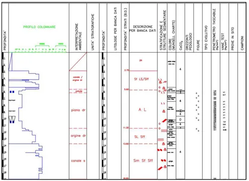
• Continuously cored borehole descriptions (20-200 m deep), from the RER database, includes two distinct types of data: stratigraphic descriptions carried out specifically in the frame of CARG Project (Fig. 12) are associated with high-resolution core descriptions, where lithology, color, consistency, contacts, accessory material, pocket penetrometer and torvane values, pedologic information and environment of deposition are specified. Uncalibrated radiocarbon dates are locally provided.
Fig. 12. Example of detailed stratigraphic core description from CARG Project.
Other stratigraphic descriptions (Fig. 13) were collected for hydrogeological surveys and may lack information such as accessory material, consistency and environment of deposition.
23
• Water wells (15-450 m deep), drilled for hydrogeological purposes, commonly have scarce vertical resolution (Fig. 14): only thick sedimentary bodies are recorded, with basic grain-size or aquifer/aquitard information. Additional annotations on color, grain size tendencies and organic matter content are rarely presented. This kind of data was utilized for identifying fluvial-channel sand bodies, and for their correlation throughout the study area.
Fig. 14. Example of poor-quality stratigraphic description (water-well log from the RER database).
• Cone penetration tests (CPT) and cone penetration tests with piezocone (CPTU) (5-36 m deep) are a powerful, though indirect, tool for high-resolution stratigraphic correlations that are commonly used for geotechnical studies. These tests attest soil resistance to penetration providing cone resistance (Qc) and sleeve friction (fs) values, and also pore
water pressure (u) values for CPTU. These tests are relatively low-cost and present high vertical resolution (Fig. 15), with a mean investigation depth of 15 cm for CPT, and 36 m for CPTU. The efficiency of CPT/CPTU tests for facies characterization and
24
stratigraphic correlation, following stratigraphic calibration with adjacent cores, on late Quaternary deposits has been studied by Amorosi and Marchi (1999) and Styllas (2014). The reader is referred to these works for detailed information about their stratigraphic use.
25
The available stratigraphic data were reinterpreted, adding a sedimentological perspective to simple lithologic descriptions. Facies associations and depositional environments were reconstructed giving specific attention to accessory materials. We particularly focused on elements that could lead to paleosol identification, such as consistency, color, reaction to HCl, carbonate concretions and pocket penetrometer values (see Manuscript 1 for further information on this latter technique). The reinterpreted logs (Fig. 16) were then plotted onto stratigraphic cross sections.
Fig. 16. Re-interpreted stratigraphic description of a RER core. On the left, stratigraphic log and facies interpretations.
26
The chronologic framework was ensured by uncalibrated dates from the RER database, and by organic-rich samples from new cores, dated at CIRCE laboratory (Caserta, Italy), and at KIGAM laboratory (Republic of Korea). Uncalibrated dates were then calibrated using Oxcal 4.2 (Ramsey and Lee, 2013), with the Intcal13 calibration curve and Marine13 dataset (Reimer et al., 2013) as shown in Fig. 17.
Fig. 17. Oxcal 4.2 radiocarbon dating example. Free online source at https://c14.arch.ox.acuk/oxcal/OxCal.html.
3.2 Petrel data processing
In addition to classic two-dimensional cross-sections, a 3D software, Petrel, was also used to analyze data and reconstruct three-dimensional paleotopographies. The first necessary step was the preliminary 2D stratigraphic analysis of boreholes and CPTU tests, which were added to the software and examined through a series of NW-SE and SW-NE cross sections (Fig. 18). The aim was the identification and geometric characterization of paleosols and fluvial-channel bodies (see next chapter, for detailed description).
Fig. 18.
Example of
core and CPTU interpretations
from a 2D
cross-section on Petrel 2014.
27
When the 2D stratigraphic correlations were reliable, it was used the convergent interpolation algorithm to recreate a 3D geometry of the picked surfaces. The convergent gridder (Fig. 19) takes a set of randomly distributed scattered points and computes an output grid showing a high-quality model representation of the input data. This type of algorithm adapts to a sparse or dense data distribution through converging iterations at finer grid resolution. Stratigraphic surfaces were then manually modified to better fit a geologic model.
Fig. 19. Example of the gridder used for 3D reconstructions.
Although Petrel is used especially for seismic analysis, in this work it was adapted to our specific needs, such as sparse data correlation and interpretation. Its application goes beyond 3D reconstructions and modelling, as it was found very useful for classic 2D correlations too, to ensure reliable facies correlations in cross-sections that can be rapidly generated.
29
4. MANUSCRIPT SUMMARY
This work focuses on the Late Quaternary succession of the southern Po Basin starting from a more proximal position and progressively moving towards distal areas, with the aim of linking a pure alluvial succession to a coastal one. Four regions (Fig. 20) were studied with different purposes: in the first area we developed a low-cost method to recognized indurated horizons, i.e. paleosols, within monotonous alluvial succession. Then, we moved slightly seawards: in the second area, the lateral continuity of paleosols was tested, and in the third one, we reconstructed the three-dimensional paleotopography of two paleosols. Finally, we proceeded towards the coastal portion of the basin (areas 4 and 5), where stratigraphic relationships between alluvial deposits and coeval coastal facies were studied, with special focus on the internal subdivision of coastal deposits into millennial-scale depositional cycles.
30
4.1 Manuscript 1
The value of pocket penetration tests for the high-resolution palaeosol stratigraphy of late Quaternary deposits
Amorosi A., Bruno L., Campo B., Morelli A.
Geological Journal 50 (2015), 670-682.
The first study area is represented by ca. 6,750 km2 of mud-prone alluvial deposits, including the Reno and Panaro rivers interfluves, where we developed a simple, low-cost method of paleosol identification through geotechnical tests. Pocket penetrometer (PP) values, which indicate the resistance of the fresh core to penetration, are a common accessory constituent of even poorly-described cores. Three cores were used for facies analysis and PP values calibration, and 40 core descriptions with associated PP profiles were extracted from the RER database, and used as tests for paleosol identification. This study showed that weakly-developed paleosols (with A-Bk-C horizons) can be traced for more than 30 km owing to their typically indurated profile that can be inferred from traditional core descriptions. It is also emphasized here a new tool to expand the coverage of stratigraphic data. By comparison with available stratigraphic descriptions, one of the major outcomes of this study is that paleosols are hardly recognized by geologists with no specific sedimentological training.
4.2 Manuscript 2
Paleosols and associated channel-belt sand bodies from a continuously subsiding late Quaternary system (Po Basin, Italy): New insights into continental sequence stratigraphy.
Amorosi A., Bruno L., Cleveland D.M., Morelli A., Hong W.
Geological Society of America Bulletin (2016), in press.
This work was conducted in slightly more seaward position, on a 3,800 km2 portion of the southern Po Plain, between the Po River and the Apennines. The aim of this study was to examine paleosol geometries and their relationships with coeval fluvial-channel bodies. Four SW-NE transects were constructed and analyzed in the area using 20 new cores (from the ExxonMobil partnership and RER stratigraphic database), 52 field log descriptions, 69 water-well cuttings and 118 CPT/CPTU tests from the RER database. The chronostratigraphic framework was defined by a
31
total of 100 radiocarbon dates, 44 of which are unpublished. The study revealed a bipartite stratigraphic zonation, with a paleosol-bearing succession close to the basin margin that is replaced by vertically-amalgamated fluvial bodies in axial position (beneath the modern Po River). No evidence of a persistent incised-valley system was found in the Po system during the last glacial/interglacial period. Continuous accommodation led, instead, to the deposition of a dominantly aggradational alluvial succession.
4.3 Manuscript 3
Reconstructing Last Glacial Maximum and Younger Dryas paleolandscapes through subsurface paleosol stratigraphy: an example from the Po Basin, Italy.
Morelli A., Bruno L., Cleveland D.M., Drexler T.M., Amorosi, A.
Geomorphology, submitted.
This work represents the natural prosecution of the previous one, and was carried out in a 3,000 km2 area, between the Panaro River and the modern coastal region. This study involved the three-dimensional reconstruction of paleosols and genetically related sand fluvial bodies geometries, with special focus on the paleotopography at the onset of the Last Glacial Maximum and Younger Dryas cold reversal. 17 recently-drilled continuous cores, 107 core descriptions and 1012 CPT/CPTU tests represented the tie points for facies and stratigraphic surface correlations using Petrel, the Schlumberger’s software for 3D analysis. 27 additional radiocarbon dates from the two studied periods were used as guides to the stratigraphic reconstruction. A second objective of this study was the geometric analysis of the LGM and YD fluvial channel belts, from the Apennines to the Po River.
4.4 Manuscript 4
Global sea-level control on local parasequence architecture from the Holocene record of the Po plain, Italy.
Amorosi A., Bruno L., Campo B., Morelli A., Rossi V., Scarponi D., Hong W., Bohacs K.M., Drexler T.M.
32
The transition from a pure alluvial to a marine-influenced succession was carried out with this fourth study, where an area approximately 3,200 km2 between Ferrara and the modern Po delta was investigated. The Holocene, post-Younger Dryas depositional history of the Po coastal plain was assessed in this work based on 12 sediment cores, 2,350 RER stratigraphic descriptions, 131 radiometric dates, 740 paleontological analysis, and the construction of two 50 km-long W-E transects. The response of the Po Plain coastal system to short-term sea-level fluctuations was examined, highlighting parasequences, millennial-scale depositional packages bounded by flooding surfaces, developed as key features for stratigraphic correlations. This work led to the reconstruction of the paleoenvironmental evolution that characterized parasequence development. We also demonstrate that the landward equivalent of marine flooding surfaces can be defined by brackish and freshwater fossil assemblages, and traced for tens of kilometers into the non-marine realm.
4.5 Manuscript 5
Po Plain, Last Glacial Maximum depositional sequence, Upper Pleistocene to Holocene, Italy.
Campo B., Morelli A., Amorosi a., Bruno L., Scarponi D., Rossi V., Bohacs K.M., Drexler T.M.
American Association of Petroleum Geologists Memoirs, Chapter 16, ready to be submitted.
The last work represents a late Quaternary methodologic study from an approximately 1140 km2 area in the Ferrara and Ravenna coastal plain. The post-LGM, Upper Pleistocene-Holocene succession was analyzed in this chapter as a modern analog for ancient rock formations for which a well-constrained chronostratigraphic framework is commonly unavailable. Two W-E transects from Manuscript 4 were used as an example of sequence-stratigraphic approach to a modern succession. This study indicates that sequence stratigraphy may represent a valuable tool for analyzing meter-scale stratal units at millennial to centennial meter-scales in systems with sufficiently high accommodation and sediment-supply rates to record high-frequency changes. As the stratal record documents an integrated response to changes in rates of accommodation relative to sediment supply, this approach can be applied to generate useful insights even in settings not dominated by standing water (i.e., marine or lacustrine).
34
5. MANUSCRIPTS
5.1 Manuscript 1
The value of pocket penetration tests for the high-resolution palaeosol
stratigraphy of late Quaternary deposits*
Amorosi A., Bruno L., Campo B., Morelli A.
35
The value of pocket penetration tests for the high-resolution palaeosol
stratigraphy of late Quaternary deposits
Alessandro Amorosia*, Luigi Brunoa, Bruno Campoa, Agnese Morellia
Dipartimento di Scienze Biologiche, Geologiche e Ambientali, University of Bologna, Bologna, Italy
36
Abstract
Pocket penetrometer measurements, though commonly listed as accessory components of core descriptions, are almost totally ignored in shallow subsurface stratigraphic analysis. In this study, we prove that, if properly calibrated with core data, pocket penetration tests may serve as a quick and inexpensive tool to enhance high-resolution (palaeosol-based) stratigraphy of unconsolidated, late Quaternary non-marine deposits. A palaeosol sequence, made up of 12 vertically stacked, weakly developed palaeosols (Inceptisols) dated to the last 40 ky cal BP, is reconstructed from the subsurface of the southern Po Plain. The individual palaeosols exhibit flat to slightly undulating geometries and several of them can be tracked over distances of tens of km. They show substantially higher compressive strength coefficients than all other fine-grained, alluvial (floodplain) facies, being typified by distinctive penetration resistance, in the range of 3.5-5 kg/cm2. Along the palaeosol profiles, A and Bk horizons demonstrate consistent difference in relative compressive strengths, the highest values being invariably observed at the A/Bk boundary. Palaeosols are rarely described in conventional stratigraphic logs, and just a small proportion of them is likely to be identified by geologists with no specific sedimentological training. Through core-log calibration techniques, we document that vertical profiles of penetration resistance measured in the field can be used as an efficient method for palaeosol identification, and thus may represent a strategy for predicting stratigraphic architecture from limited core descriptions or poor-quality field logs. This technique allows to optimize the contribution of all available stratigraphic information, expanding significantly the coverage of well-described, one-dimensional core data.
Keywords: pocket penetrometer; palaeosol; alluvial stratigraphy; Quaternary; Po Plain
1. Introduction
Reconstructing the high-resolution facies architecture of the late Quaternary successions buried beneath the modern alluvial plains is an increasingly important issue for stratigraphic modeling of more ancient successions (Blum and Törnqvist, 2000; Blum et al., 2013). In shallow subsurface exploration programs, however, extensive core data are needed to obtain sufficient stratigraphic information, and drilling commonly represents the most expensive part of the whole exploration campaign. In this regard, the acquisition of a comprehensive dataset including all available
37
stratigraphic information is essential to plan future investigations, and an appropriate level of detail of the stratigraphic description can have far-reaching implications for the success of a project.
In densely populated areas, such as the modern alluvial and coastal plains, a large number of core descriptions is commonly available. However, the overall quality of field logs may vary appreciably. Geotechnical core logging generally incorporates simple lithologic descriptions that are hardly suitable for facies interpretation and, consequently, for high-resolution stratigraphy. Delineating subsurface stratigraphy through indirect methods of subsurface investigation, such as those based upon geotechnical engineering properties of soils, may partly compensate for this lack of appropriate stratigraphic descriptions.
The high potential of geotechnical data for the high-resolution stratigraphy of unconsolidated Quaternary deposits has been illustrated by Amorosi and Marchi (1999), who showed that piezocone penetration tests can be used for the detailed characterization of distinct coastal plain, deltaic and shallow-marine facies associations. The same technique was successfully applied by Lafuerza et al., (2005), Choi and Kim (2006), Sarti et al. (2012), and Styllas (2014), proving to be useful for the high-resolution sequence stratigraphic analysis and three-dimensional reconstruction of alluvial to coastal successions. Based on the same conceptual criteria, we document in this paper that, if proper calibration with core data is carried out, the use of simple pocket penetrometer resistance, a supplementary information normally available from most core descriptions, can be of use to a log analyst for stratigraphic profiling. Pocket penetrometer may provide almost continuous record of in situ properties of soils. This tool has been used for reliable assessment of the effects of compaction on soil productivity (Steber et al., 2007), to estimate threshold friction velocity of wind erosion in the field (Li et al., 2010), and for stratigraphic and geotechnical investigations (Brideau et al., 2011).
Palaeosols have long been recognized as key features for subdivision and mapping of continental strata on a variety of time scales (Bown and Kraus, 1981; Retallack et al., 1987; Besly and Fielding, 1989; Joeckel, 1991; Kraus, 1999; Atchley et al., 2004; Rossetti, 2004; Choi, 2005; Buck et al., 2010), and sequence-stratigraphic models have predicted the presumed position of palaeosols within non-marine deposits (Van Wagoner et al., 1990; Hanneman and Wideman, 1991; Wright and Marriott, 1993; Cleveland et al., 2007; Mack et al., 2010; Gibling et al., 2011; Varela et al., 2012). One of the most prominent features are palaeosols formed at interfluve sequence boundaries, i.e., adjacent to palaeovalley systems (Aitken and Flint, 1996; McCarthy and Plint, 1998).
In this paper, we demonstrate that late Quaternary palaeosols can often be identified on the basis of geotechnical properties generated from simple pocket penetrometer values (Bradford, 1980). The southern Po Plain, for which a palaeosol-based stratigraphic framework has been recently made
38
available (Bruno et al., 2013; Amorosi et al., 2014), represents an intriguing opportunity to investigate subsurface stratigraphy based on this approach. To this purpose, we selected a mud-prone, distal alluvial succession between the basin margin and the Po channel belt, with specific focus on the interfluve between Panaro and Reno rivers (Fig. 1). We strategically chose this area because of lack of laterally continuous fluvial bodies that could be utilized as stratigraphic markers.
Figure 1. Study area, with indication of the section trace of Figures 5 and 6. The RER (Emilia-Romagna Geological, Seismic and Soil Survey) database was used to assess the engineering properties of palaeosols in Figure 7.
2. Regional geological setting
The Po Plain is a rapidly subsiding foreland basin, bounded by the Alps to the north and the Apennines to the south (Fig. 1). The formation of the Apenninic fold-and-thrust belt took place since the Late Oligocene (Ricci Lucchi, 1986; Boccaletti et al., 1990) in the framework of the collision of the European plate with the Adria microplate (Boccaletti et al., 1971; Ghielmi et al., 2013), when the sedimentary successions of the subducting margin of Adria were piled up to form the Apenninic accretionary prism (Carminati and Vadacca, 2010). The filling of the Pliocene-Pleistocene Apennineic foredeep has been estimated to exceed 7,000 meters in the thickest depocentres (Pieri and Groppi, 1981). The North Apenninic frontal thrust system, buried below the southern margin of the Po Plain makes this area seismically active, as confirmed by the recent M 5.9-6.0 earthquakes of May-June 2012. Several active thrust faults have been recognized, such as the Ferrara and Mirandola growing anticlines, this latter with an uplift of ca. 0.16 mm/y in the last 125 ky (Carminati and Vadacca, 2010).
39
Extensive subsurface investigations carried out during the last two decades with the aim of establishing a general framework of aquifer distribution have led to accurate reconstruction of the large-scale, subsurface stratigraphic architecture of the Pliocene-Quaternary basin fill (Di Dio, 1998; Carcano and Piccin, 2002). Six depositional sequences were identified south of Po River (Di Dio, 1998; Molinari et al., 2007) and four north of Po River (Carcano and Piccin, 2002). These depositional sequences, recognized on a seismic basis and typically bounded by stratigraphic unconformities of tectonic origin, correspond to 3rd-order depositional sequences in the sense of Mitchum et al. (1977). The lower boundary of the youngest depositional sequence (Po Supersynthem of Amorosi et al., 2008) has an estimated age of 0.87 My (Muttoni et al., 2003), and is partitioned into eight lower-rank (4th-order) depositional cycles (transgressive-regressive – T-R – cycles of Amorosi and Colalongo, 2005 – see Fig. 2).
Pollen characterization of the youngest two T-R cycles has documented a glacio-eustatic control on facies architecture, with a major influence of Milankovitch-scale eccentricity (ca. 100 ky) cycles (Amorosi et al., 1999, 2004, 2008). The T-R cycles are best recognized beneath the modern coastal plain and the delta, where typical transgressive-regressive coastal wedges form the transgressive and highstand systems tracts (TST+HST in Fig. 2). These shallow-marine bodies are separated by thick packages of alluvial deposits (falling-stage and lowstand systems tracts – FST+LST), the accumulation of which was favoured by tectonic subsidence.
Figure 2. Transgressive-regressive (T-R) cycles in the subsurface of the Po Plain and their sequence-stratigraphic interpretation (from Amorosi et al., 2014). The red lines represent the transgressive surfaces. The lower parts of the T-R cycles have a typical interglacial (transgressive/highstand systems tracts - TST+HST) signature, and are marked by diagnostic coastal wedges in lateral transition to mud-prone alluvial deposits. The upper parts of the T-R cycles, formed under glacial conditions (falling stage/lowstand systems tracts - FST+LST), display increasingly amalgamated fluvial bodies. The black rectangle shows approximate position of the stratigraphic correlation panel of Figure 5.
40
In proximal positions, close to the basin margin, the T-R cycles consist of basal overbank facies with isolated fluvial-channel sand deposits. Upwards, the fluvial bodies become increasingly abundant, amalgamated and laterally continuous. Based upon pollen data (Amorosi et al., 2008), the transgressive surfaces (or maximum regressive surfaces of Catuneanu et al., 2009) separate lowstand, glacial deposits from overlying deepening-upward (brackish to shallow-marine) successions formed under interglacial conditions. Landwards, these surfaces can be traced approximately at the boundary between laterally-amalgamated and isolated fluvial bodies (Fig. 2). The lower parts of the T-R cycles are interpreted to represent the response of fluvial systems to rapid sea-level rise (equivalent of marine isotope stages 1, 5e, 7, 9 and 11, respectively, in Fig. 2 – Amorosi et al., 2004, 2008).
3. Materials and methods
Pocket penetrometer is a lightweight, handy tool that is commonly used for geotechnical purposes during coring operations. Its primary source of information is for evaluating consistency and approximate unconfined compressive strength. When pushing the loading piston into a freshly cut core, the pin encounters a force. A friction ring is taken along during this operation, which shows on the scale the maximum force that has been encountered. The direct reading scale, commonly ranging between 0 and 5 kg/cm2 (up to 10), corresponds to equivalent unconfined compressive strength.
In order to test our approach of using penetration tests for palaeosol identification and high-resolution stratigraphic reconstructions, we selected a distal, mud-dominated portion of the alluvial plain, away from the influence of the major rivers (i.e., the Po channel belt) and far from the thick, fluvial gravel bodies of the Apenninic margin (Fig. 2). Three freshly drilled cores from the Modena and Ferrara alluvial plain (Cores 1-3 in Figs. 1 and 3), 40-50 m long, were used as reference for facies analysis and palaeosol characterization. Coring was performed through a continuous perforating system, which guaranteed an undisturbed core stratigraphy. We also selected 40 out of 250 detailed field logs from the database of the Emilia-Romagna Geological, Soil and Seismic Survey (RER), covering a wider area (Fig. 1). Lithology, colour, and accessory components is the typical information available for each borehole. We adopted availability of the following key aspects as decisive for borehole selection: (i) pocket penetration values, (ii) colour description, (iii) reaction to HCl, (iv) 14C dating, (v) pollen data, (vi) photographs. Pocket penetration values, available uniquely from fine-grained (silt and clay) stratigraphic intervals, were stored in a specific, geo-referenced database and plotted as vertical profiles on the individual logs. In order to perform
41
stratigraphic correlations within the time window of radiocarbon dating, we adopted a 40 m depth cut-off. Beyond this depth, penetration values appear to be affected by over-compaction.
Figure 3. Detailed stratigraphy of reference cores 1 to 3, including facies interpretation, pocket penetration profiles and stratigraphic position of the 15 palaeosols identified. See Figure 1, for location. Paleosols are fingerprinted by the highest penetration values. C: clay, S: sand, G: gravel.
4. Sedimentary facies
In order to evaluate the relationships between depositional facies and resistance to penetration, detailed facies analysis and pocket penetrometer measurements were undertaken on three reference cores (cores 1-3 in Fig. 3). Five facies associations were distinguished on the basis of grain size trends, accessory components, colour and consistency.
4.1 Fluvial-channel facies association
Description. This facies association is made up of single-storey, coarse to medium sand bodies, up to 6 m thick, with erosional lower boundaries (Fig. 4a) and internal fining-upward (FU) trends. The upper boundary to the overlying muds is either sharp or gradational. Pebble layers and wood fragments are locally abundant in the lower part of the unit. No fossils were observed in this facies
42
association. Locally preserved sedimentary structures include unidirectional high-angle cross-stratification. Pocket penetration tests do not operate in sands, and for this reason no penetration values are available from this facies association.
Interpretation. The combination of textural properties, FU trends, erosional base and sedimentary structures enables interpretation of this facies association as fluvial-channel deposits. This interpretation is supported by the presence of unidirectional flow structures and abundance of floated wood. The sharp boundary to the overlying mud-prone deposits reflects abrupt channel abandonment, whereas transitional contacts suggest gradual abandonment. Simple core examination does not allow subdivision of this facies. As a whole, single-storey sand bodies are likely to represent point bar deposits.
4.2 Crevasse and levee facies association
Description. This facies association consists of fine sand bodies, generally less than 1.5 m thick, and silts and silty sands alternating on a cm scale (Fig. 4b). The sand layers exhibit (i) sharp base and gradual top, with internal FU trends, or (ii) gradual transition from the underlying muds, with sharp top and coarsening-upward (CU) tendency. Compressive strength coefficients derived from pocket penetration tests measured on silt intervals are invariably < 2.5 kg/cm2.
Interpretation. The highest sand/mud ratios recorded within this facies association are interpreted to reflect proximity to fluvial channels. In particular, sand layers with sharp base and gradual transition to the overlying muds are interpreted to have been deposited in crevasse channels, while sand layers with gradual base and sharp top are likely to reflect crevasse splays. Heterolithic units made up of silt-sand intercalations are interpreted as natural levee deposits, with sand proportion decreasing with increasing distance from the channel axis.
4.3 Floodplain facies association
Description. This facies association is made up of a monotonous succession, up to 9 m thick, of thoroughly bioturbated, variegated (5YR 8/1, 2.5Y 7/2-5, 5Y 6/1) silts and clays (Fig. 4b). Roots and plant remains are commonly encountered. Iron and manganese oxides are abundant. No sedimentary structures were observed, with the exception of faint horizontal lamination. Concentration of organic matter is locally encountered. Thin very fine sand beds with sharp base
43
were occasionally seen. Pocket penetration values for this facies association commonly are in the range of 1.5 and 2.5 kg/cm2 (average value 2.0 kg/cm2).
Interpretation. Based on the dominance of bioturbated and oxidized muds, this facies association is interpreted to reflect background deposition of mud from suspension, in a low-energy, subaerially exposed depositional environment (floodplain). Lack of sedimentary structures is due to bioturbation. Local grey, organic-rich clays are likely to reflect areas of low topographic relief with poor drainage and high water table. The thin sand layers reflect the distal fringes of either crevasse splays or levee deposits.
4.4 Freshwater swamp facies association
Description. Soft grey and dark grey clays (7.5YR 7/1, 5YR 5/1), with subordinate silts and sandy silts compose this facies association, up to 1.8 m thick. Plant debris, wood fragments and peat layers are frequently encountered (Fig. 4c). Vertical variations in grain size, at a few cm scale, and thin organic-rich layers confer a characteristic horizontal lamination to this facies association. Extremely rare carbonate concretions are encountered. Iron and manganese oxides are absent. This facies association is typified by very low pocket penetrometer values, almost invariably lower than 1.2 kg/cm2 (Fig. 3).
Interpretation. Organic soft clays with abundant plant fragments are interpreted to have been deposited in paludal environments under predominantly reducing conditions. Horizontal lamination is inferred to be the result of the progressive accumulation of organic material, interrupted by occasional flood events. Very low resistance penetration values reflect undrained conditions and submergence. Temporary phases of subaerial exposure, with consequent lowering of the water table, are inferred to have been responsible for local hardening of the clay and the formation of scattered carbonate concretions.
4.5 Palaeosols
Description. Visual examination and manipulation of cores 1-3 with respect to colour, texture and plasticity led to recognition of 15 relatively stiff clay horizons, intercalated at various stratigraphic levels within floodplain deposits (Fig. 3). These clay horizons are commonly identified by the combination of dark, brownish (10YR 3/2, 2.5Y 3/1) colour and no reaction with acid. The
44
organic clay generally overlies, with gradual transition, lighter (10YR 8/2, 2.5Y 8/2), iron mottled clays and silts, rich in carbonate concretions (Fig. 4d-e). The organic horizons and the associated carbonate-rich clays are typified by substantially higher penetration values than those recorded in the overlying and underlying floodplain clays (Fig. 3). In particular, the darker horizons display average coefficients of compressive strength around 3.5 kg/cm2, while the underlying carbonate-rich horizons are even more consolidated (average penetration values 3.9 kg/cm2). An abrupt increase in compressive strength, of at least 1 kg/cm2 relative to the overlying deposits, commonly marks the upper boundary of the organic layers (Fig. 3).
Interpretation. Based on field observations, the indurated horizons are interpreted as weakly developed palaeosols (Inceptisols of Soil Survey Staff, 1999), marking short-lived phases of subaerial exposure, on the order of 3,000-4,000 thousands of years (Amorosi et al., 2014). The Inceptisols are mostly developed on floodplain muds and seem to alternate rhythmically with non-pedogenized, heterolithic intervals of small channel belts and crevasse/overbank facies. The dark, organic-rich clays reflect accumulation of organic matter and leaching of calcium carbonate in topsoil (A) horizons. The underlying clays include pedogenic calcium carbonate, and are inferred to represent Bk or calcic horizons, subject to fluctuating redox conditions and processes of iron dissolution and redeposition. Highly compacted sediments of pedogenic origin, with similar sedimentological features and unconfined compressive strength coefficients of about 4-5 kg/cm2, have been reported about 120 km NE of the study area, from the subsurface of the Venice lagoon (Donnici et al., 2011). In humid to subhumid climates, Inceptisols similar to those observed in cores 1 to 3 have been interpreted to represent subaerial exposure of a few thousands of years only (Retallack, 2001; Buol et al., 2011).
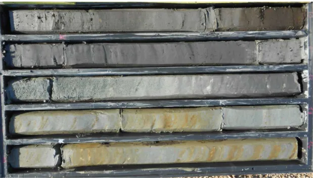
Figure 4. Representative core photographs of the study succession (bottom: lower right corner). a: Erosional lower boundary of a fluvial-channel sand body (FC) above floodplain clays (F). b: Floodplain clays (F) gradually overlain by crevasse/levee sandy silts (CL). c: Freshwater swamp clays and peat. d: Inceptisol (with differentiation into A and Bk horizons) overlain by floodplain silts and clays. Core 2, 17-18 m depth (palaeosol D in Fig. 6). e: Close-up of an Inceptisol, with subdivision into A and Bk horizons. Core 2, 27 m depth (palaeosol G in Fig. 6). Core width is 10 cm.