UNIVERSITA' DI BOLOGNA
SCUOLA DI SCIENZE
Corso di Laurea Magistrale in BIOLOGIA MARINA
Ecological distribution of semi-demersal fishes in space
and time on the shelf of Antalya Gulf
Tesi di laurea in Biologia delle Risorse Alieutiche
Relatore Presentata da
Prof. Fausto Tinti Ilaria de Meo
Correlatore
Prof. Erhan Mutlu
I sessione
ABSTRACT
In this study we provide a baseline data on semidemersal fish assemblages and biology in a heterogeneous and yet less studied portion of the shelf of Antalya Gulf. The distribution of fish abundance in three transects subjected to different fisheries regulations (fishery vs non fishery areas), and including depths of 10, 25, 75, 125, 200 m, was studied between May 2014 and February 2015 in representative months of winter, spring, summer and autumn seasons. A total of 76 fish species belonging to 40 families was collected and semidemersal species distribution was analyzed in comparison with the whole community. Spatial distribution of fish was driven mainly by depth and two main assemblages were observed: shallow waters (10-25; 75 m) and deep waters (125-200 m). Significant differences among transects were found for the whole community but not for the semidemersal species. Analysis showed that this was due to a strong relation of these species with local environmental characteristics rather than to a different fishing pressure over transects. Firstly all species distribute according to the bathymetrical gradient and secondly to the bottom type structure. Semidemersal species were then found more related to zooplankton and suspended matter availability. The main morphological characteristics, sex and size distribution of the target semidemersal species Spicara smaris (Linnaeus, 1758), Saurida undosquamis (Richardson, 1848), Pagellus acarne (Risso, 1827) were also investigated.
TABLE OF CONTENT
1. INTRODUCTION
1.1. The ecological framework………..…………1
1.2. The study area……….5
1.2.1. Environmental characteristics……….5
1.2.2. The demersal fisheries………..………7
1.3. Target species………10
1.3.1. Spicara smaris (Linnaeus, 1758)………10
1.3.2. Saurida undosquamis (Richardson, 1848)………..…………..11
1.3.3. Pagellus acarne (Risso, 1827)……….…12
1.4. Objectives of the study………..………13
2. MATERIAL and METHODS………...……..14
2.1. Study area and field sampling……….……….14
2.2. Trawling………...……..15 2.3. Deck work………..16 2.3.1. Environmental parameters………..16 2.3.1.1. Physical parameters……….16 2.3.1.2. Chemical parameters………..17 2.3.1.3. Biological parameters……… 17 2.3.2. Fish collection………18 2.4. Laboratory work………19 2.4.1. Environmental parameters……….19 2.4.1.1. Chemical parameters……….19 2.4.1.2. Biological parameters………19 2.4.1.3. Geological parameters………..20
2.4.2. Fish analysis……….20 2.5. Statistical analysis………..21 2.5.1. Preliminary work……….21 2.5.2. Numerical indices………22 2.5.3. Target species………22 2.5.4. Faunistic characteristics……….23
2.5.5. Assemblage structure: tests and ordinations………..24
2.5.5.1. Permutational analysis of variance (PERMANOVA)………..24
2.5.5.2. Species clustering and ordination………..24
2.5.5.3. Representative species………..25
2.5.6. Relations between biotic and environmental variables………25
2.5.6.1. BIO-ENV analysis……….25
2.5.6.2. Canonical analysis………..26
3. RESULTS………27
3.1. Environmental characteristics………..31
3.1.1. Physical, chemical, biological characteristics………..31
3.1.2. Seabed classification……….31
3.2. Fish assemblages……….32
3.2.1. Species composition……….32
3.2.2. Numerical indices……….…..34
3.2.3. Target species………35
3.2.3.1. Spicara smaris (Linnaeus, 1758)………..35
3.2.3.2. Saurida undosquamis (Richardson, 1848)……….38
3.2.3.3. Pagellus acarne (Risso, 1827)………41
3.2.4. Faunistic characteristics……….44
3.2.5. Multivariate biotic pattern………48
3.2.5.1. Permutational analysis of variance (PERMANOVA)………..48
3.2.5.3. Representative species………..55
3.3. Relations between biotic and environmental variables………59
3.3.1. BIO-ENV analysis………..59 3.3.2. Canonical analysis………60 4. DISCUSSION………..61 5. CONCLUSION………75 REFERENCES………..76 ACKNOWLEDGMENTS………83
1
1. INTRODUCTION
1.1. The ecological framework
Marine ecosystems provide key services which are essential for maintaining life on our planet. Marine services are provided both at a global scale with oxygen production, nutrient cycles or carbon fixation and at regional and local scales with bioremediation of waste and pollutants or stabilizing coastlines, to name a few examples. These services also include important economic benefits for humans such as food provision and tourism (Atkins et al., 2011; Balmford et al., 2010).
Ecosystem dynamics are an integrated response of the various ecosystem components to the several drivers that act independently but that can have synergistic or antagonistic effects. Living marine resources are affected by three main drivers: anthropogenic, trophodynamic and environmental processes (Fu et al., 2012). The interaction of these drivers is not easy to be disentangled, making it difficult to determine precisely which changes are results of direct human influence. It is clear, however, that deteriorating biodiversity impairs the marine ecosystem's capacity to maintain the services working properly (Worm et al., 2006).
Among anthropogenic drivers, over-exploitation of marine resources through fisheries activities is the most important in many marine ecosystems. The world’s oceans are at or near maximum sustainable fishery yields. United Nations Food and Agriculture Organization's estimation that “75% of the world's fisheries are fully- or over-exploited” has been widely quoted (UN FAO 2000). While the consequences of overharvesting are expressed in social, economic, cultural and ecological changes, the ecological consequences of overfishing often are undocumented and may be poorly known or overlooked. Geographical distribution, biomass and abundance, reproduction, recruitment, growth, and energy allocation of fish populations may respond differently due to these changes (Jørgensen et al., 2008). At the population level, impacts of fishing are direct and indirect.
2
First of all fisheries remove the oldest, largest individuals from the exploited populations. In this way sex ratio can be modified since many species are hermaphrodites and can change sex once they reach a certain size. As a result, the reproductive potential of a species can be altered, following in a negative outcome for recruitment (Hamilton et al., 2007). Indirect effects include genetic selection affecting growth rates and reproductive output through a decreasing in age and size at maturation (Enberg et al., 2012). There are potential indirect effects driven by overexploitation also at the community level. Fishing is typically a size-selective agent of mortality and, therefore, it is unlikely to be the natural cause of mortality. Most of the fish removed by fishing activities are in the middle or near the top of food webs in their habitats and thus fishing can be considered as the removal of a keystone predator. Depletion of the largest species tends to release predation pressure which can result in a better survival rate of the smallest species with the modification of the food web propagation (Stevens et al., 2000). When a species is less abundant because of overexploitation, ecological niche doesn’t remain free but is occupied by other species, often resulting in competition and then accentuating even more the effects due to fishing. In addition this circumstance can be intensified by exotic introductions which often take opportunistic advantage replacing native species. The ecological effects of fishing are therefore substantially greater and more complex than simply the removal of biomass. Furthermore, the trawl net has a very low selectivity and studies available show that 26% of the world's catch is discarded annually (Alverson et al., 1998). Discarding is usually caused by economic or regulatory constraints because the fish are too small to be retained or the species are unmarketable. This phenomenon can then be a substantial component of fishing mortality and may aggravate overfishing (Hilborn et al., 2003). In addition bottom trawling often reduces hard substrate and simplifies the ground topography determining consistent and persistent alterations of the benthic habitats (Jennings et Kaiser, 1998).
As previously introduced, for a full comprehension of the dynamics that underlie marine communities, it would be necessary to consider, in addition to the disturbance caused by
3
human activities, also the potential effects on the ecosystem determined by changes in certain environmental and climatic variables. Fishing through the removal of biomass from a complex of species that feed one other is certain to have an impact on the ecosystem. Likewise, changes in primary production can affect the amount of available food that is propagated towards the higher trophic levels, leading to changes in the flux of energy that are noticeable throughout the food-web. Primary producers, the phytoplanktonic organisms, depend on sunlight in the upper pelagic layers of the ocean and absorb nutrients from water in order to reproduce and grow. The phytoplankton provides the primary food source for the zooplankton and together they form the first step of the oceanic food chain. Indeed fish rely on the density and distribution of zooplankton which is the initial prey item for almost all fish larvae (Pershing et al., 2005).
Temperature, salinity, currents, river inputs, storm runoff have an effect on marine communities that could interact with the influence exerted by fishing (Kennish et al., 2002; Lloret et al., 2001). The natural factors can affect a population during various stages of the life cycle: the recruiting (Abella et al., 2008), the development of eggs (Horne and Smith, 1997; Alvarez et al., 2001), the larval stage (Sebatés et al., 2007). The temperature definitely plays a significant importance in the life cycle of ectothermic organisms, unable to maintain a body temperature different from the external one. Numerous studies suggest that surface temperature of water may have some effects on the population dynamics of fish stocks and even small changes at deeper waters are, however, related to what happens at the surface (Palomera et al., 2007; Nunn et al., 2010). Moreover, the phases of the biological cycle most sensitive to temperature are the larval development, growth, sexual development and the production of eggs (Hidalgo et al., 2011), steps that in the majority of cases occur in the vicinity of the coastline, area showing wide variations in chemical and physical parameters. The wind, currents and storms are fundamental factors for water column mixing and especially in lifting of deep waters, which is often associated with an increase in the content of dissolved nutrients. In addition water mixing turns out to be very important also for the movement and the spatial distribution of the planktonic organisms, which can in turn
4
strongly affect larval dispersal and therefore breeding success and fish survival (Palomera et al., 2007; Lloret et al., 2001).
Local habitat structure and its related abiotic and biotic parameters play also an important role in determining fish assemblage and abundance. Structural characteristics like sediment grain size, rocky reliefs, presence of vegetation or connectivity, can affect many behavioral strategies such as search for suitable recruitment zones, shelter from predators, day-time distribution, competition, predation, feeding habits (Robertson and Lenanton, 1984; Orth et al., 1984; Edgar and Shaw, 1995).
Finally, studies at global scale illustrate the wide range in nutrients availability fuelling fisheries production. Nutrients availability, under different conditions of enrichment and irrespectively of the sources, has a differential effect on local pelagic, and on demersal-benthic stocks (Caddy and Bakun, 1994). Under extreme oligotrophic conditions, local populations of small pelagic fish on the continental shelf are food-limited and generally small or migratory, and demersal or benthic forms tend to predominate in the landings. Moderate enrichment increases the productivity of both resident populations of small planktivorous and of demersal fishes. However if nutrient inputs to the photic zone exceed then extra production is exported to the benthic habitat and can lead to hypoxia close to the bottom, which negatively impacts demersal community. This may still, however, promote growth of resident small pelagic stocks that continue to profit from nutrient- induced blooms of planktonic organisms. The pelagic/demersal ratio (the ratio of small pelagic fish to demersal fish plus benthic landings) from fisheries landing data has been used in many studies as proxy reflecting the impact of differential nutrient enrichment levels on marine systems (de Leiva et al., 2000; Caddy et al., 2000).
Hence the importance of understanding the ecological dynamics and how they respond to the various external pressures in order to ensure the sustainability of marine resources.
5 1.2. The study area
1.2.1. Environmental characteristics
Fig. 1.1: Physical map of the Gulf of Antalya.
The Gulf of Antalya locates in the North-eastern Levantine Sea, one of the major basins of the Eastern Mediterranean (Fig. 1.1). The Antalya Gulf has a coastline of about 680 km in length, with an average depth exceeding 1000 m and reaching a maximum of 2500 m. The western and the eastern parts of the gulf differ by their bathymetric and oceanographic characteristics. The width of the continental shelf ranges from less than 1 to 8 km, being wider in the east and steeper in the western part. In many places mountains rise up immediately behind the coasts to form the Western Taurus Mountain belt, reaching heights up to 3070 m. Numerous rivers reach the sea providing a large fresh water supply. The main streams and Managavat River reach the sea in the eastern part of the shelf causing lower salinity comparing to the western part.
The variability of meteorological conditions is one of the distinguishing characteristics of the Eastern Mediterranean. This is because the region is a pathway for extratropical cyclones during winter and spring (Bingel et al., 1993). Circulation and current patterns off the coast of the gulf of Antalya can be related to wind-stress, thermoaline flux and barotropical
6
components. As a result surface currents flow in different direction throughout the year (Vigo et al., 2005). The water formed in Aegean Sea sinks into the deepest parts of the basin. This sinking water transports all nutrients down in the deeper layers. In addition high temperature and salinity, geophysical, arid climatic conditions and low nutrient supply from external sources, make Levantine Sea extremely depleted and one of the most oligotrophic seas (Bingel et al., 1993).
The productivity of the study area is thus strongly influenced by local processes resulting in a local seasonal production. The majority of the streams which drain coastal hinterland to supply sediment into the gulf are of ephemeral nature and flow unsteadily throughout the year. Observations of high nitrate and phosphate levels in the surface waters are observed during late winter and spring due to the heavy rainfall and intense river input. Moreover large amounts of terrigenous material may be transported to the coast especially after snowmelt.
In addition to low nutrients concentrations, the eastern Mediterranean has low plankton biomass and production. Phytoplankton production is principally dominated by the extent and duration of winter mixing of the water column due to due to storms and turbulence, providing transportations of nutrients from the deeper layer. Chlorophyll concentrations previously recorded in the Levantine basin are low, not exceeding 1 μg/L. The Chl-a concentrations vary seasonally occurring with higher values during late winter, with the onset of mixing of the upper layers (Bingel et al., 1993). Also zooplankton distribution is affected by environmental variables. The species are evenly distributed in the water column due to mixing process during winter and they aggregate in the surface water down to 25 m depth where optimum temperature is present in spring and autumn.
At last Antalya gulf is under the influence of pollution due to the intense tourism activities, commercial and tourist boat traffic, residential areas with dense population. Antalya region, with a resident population of 1.98 million, in 2010 hosted the 32% of overall tourism activity
7
of Turkey with more than 8.5 million visitors occurring especially during summer along the coastline. This causes an increase of land-based pollutants and river discharges to the sea (Güven et al., 2013).
1.2.2. The Demersal Fishery
Turkey, with its favorable geographic position, has a great access to the fish resources. The entire coastline spans more than 8,400 km in length and borders four distinct sea basins: the Mediterranean to the south, the Aegean to the west, the Sea of Marmara in the north-west between the European and Asian lands, and the Black Sea to the north. The total national catch between 1991 and 2008 averaged 474,000 tons per year, fluctuating between 317,000 and 589,000 tons (SUBIS, http://www.ulakbim.gov.tr). Fisheries resources are disparate and vary substantially between the basins. Black Sea landings represent 75% of total national landings. Here fisheries are largely dominated by the abundant occurrence of small pelagics, the most important species of which are the anchovy and the horse mackerel (FAO, 2011). In Mediterranean and Aegean Seas important demersal and semi-pelagic stocks of fish and shrimps dominate. Tuna and other large pelagics such as bonito, bluefish and mullet are also important in the Mediterranean.
8
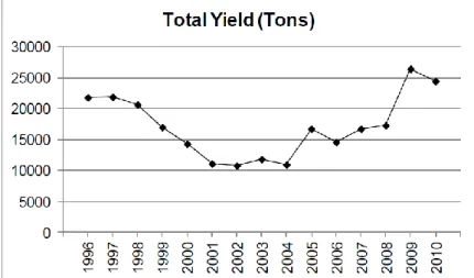
Fishery in the Turkish Mediterranean is mainly coastal and artisanal, with relatively high number of small professional fishing boats whose operations are limited to coastal shallow zone and do not expand to the continental shelf. It operates in biologically poor waters and landing of relatively high price (Bingel et al., 1993). Annual yields of the Turkish fleet in the Mediterranean are given in Figure 1.2. However it should also be taken into account that since the collection of the fisheries statistics are based on fishermen’s questionnaires, it could not be strictly reliable and the values could not always reflect the real catch data (Bingel et al., 1993). On the basis of the fish data set of the years 1978-1991, a maximum sustainable yield (MSY) (only for trawl fishery) of 7,770 tons was found (Gücü and Bingel, 1994).
The gulf of Antalya due to sudden increase in depth of the shelf is very limited for trawling. A total of 4509 tons is the annual fisheries production of the region, with 3094 tons belonging to aquaculture, which is a rapidly developing sector, and an amount of 1415 tons of products obtained by hunting. Small scale fishery has an important role as for the rest of the southern coast of Turkey. There are 690 fishing vessels and 97% are smaller than 12 m length. Gill and trammel nets with different combinations of gear characteristics and mesh sizes are traditionally used (Olguner et al., 2013). Fisheries activities are forbidden during the whole year within 2 miles from the coast. Moreover the gulf comprises two different regions, an area opened to fisheries activity and a protected area. The first area comprises the coast between Lara district and the city of Side, the latter goes from Side to Gazipașa. Here bottom trawling activity is forbidden from 9 Years within the R.G. 26.02.2005/ 25739.
Studies on the fish assemblages in the Gulf of Antalya are extremely limited. Few studies concerning the demersal fish community of the shallow continental shelf area of the North-eastern Levant Sea are available. Predominant catches are bottom-dwelling species of high diversity including Red Sea emigrants (Bingel et al., 1993). The faunal composition of the Turkish Mediterranean coast has been changed dramatically due to the construction of Suez Channel in 1869 which allowed the introduction of numerous Indo-Pacific species from the
9
Red Sea (Galil 2009). The impacts of Lessepsian species in the Levantine basin of the Mediterranean have proven to be considerably high, where they are replacing native species. In total 62 species of non-native marine fishes arrived to NE Mediterranean by natural dispersal via the Suez Canal (Goren and Galil, 2005). Invasive species have become a major component of commercial catches and study conducted between 1980 and 1984 in the North-eastern Turkish coasts showed that Lessepsian fishes constituted up to 74.5% of fish landings during the study period (Gücü and Bingel, 1994b).
Bingel et al., (1993) listed economically important and locally marketed species in the Levantine Sea as follows: Brushtooth lizardfish (Saurida undosquamis), Red mullet (Mullus barbatus), Goldband goatfish (Upeneus moluccensis), Common sole (Solea solea), Common pandora (Pagellus erythrinus), European hake (Merluccius merluccius), the Common shrimp (Penaeus sp.) and the Common cuttlefish (Sepia officinalis). Species with the highest percentage in main catch was Saurida undosquamis. In addition, when applying the yield per recruit (Y/R) model to the stocks whose population parameter were estimated, showed that except Saurida undosquamis all other stocks were overfished in the region.
10 1.3. Target species
1.3.1. Spicara smaris (Linnaeus, 1758)
Fig. 1.3: Adult specimen of Spicara smaris (Linnaeus, 1758)
Spicara smaris (Linnaeus, 1758), commonly known as picarel, is a bony fish of the Centracanthidae family. This species is distributed in the eastern Atlantic from Portugal to Marocco and throughout the Mediterranean Sea and the Black Sea. The picarel is a sociable fish, forming large schools over seagrass beds and sandy or muddy bottoms and can be generally found at a depth range from 15 to 170 m. It grows to a max length of 20 cm but a more common length is 14 cm (FISHBASE, http.//www.fishbase.org). It is a more slender fish than the congener Spicara maena and can be distinguished by the related species by having lower scale number (75-81) along the lateral line, vomerin teeth usually absent and a linear snout shape. Its back is grey-brown and it has a silvery flank with a distinctive large black spot. Males are usually larger than female and become brighter at the breeding time. It is a protogynous sequential hermaphrodite, individuals maturing as females and turning into males later. All individuals over about TL = 17 cm are males. Reproduction takes place once per year from February to May (WoRMS, www.marinespecies.org). Spicara smaris is a zooplanktivorous fish. Copepoda are the most important food item and it can also occasionally prey upon fish larvae (Karachle et al., 2014). The Picarel is a species with minor
11
but increasing commercial fisheries importance and among the ten most abundant fish species caught in Turkey (Harlioğlu 2011).
1.3.2. Saurida undosquamis (Richardson, 1848)
Fig. 1.3: Adult spiecemen of Saurida undosquamis (Richardson, 1848)
The brushtooth lizardfish, Saurida undosquamis (Richardson, 1848), is a Lessepsian fish. The natural distribution range of S. undosquamis includes the Indo-West Pacific Ocean from the Red Sea and Eastern Africa to southern Japan and Australia. In Mediterranean it was recorded first in Israel (Ben-Tuvia, 1953), becoming one of the most successful invaders throughout the Levant basin. The brushtooth lizardfish is currently the most exploited alien fish in Turkey, comprising almost one-third of the commercial trawl catch in the north-eastern Levant (Cinar et al., 2005). Common lengths range from TL = 20-30 cm although individuals up to 50 cm were reported (FISHBASE http.//www.fishbase.org). The body is slender and cylindrical. The head is slightly depressed with a large mouth and long jaws from which stick out numerous needle-like teeth. It appears brown-beige on the back with silvery white belly and a series of dark spots along the lateral line. It is found in zones above 100 m over sand or mud bottoms of coastal waters and feeds mainly on pelagic fishes (anchovy)
12
and, to a lesser extent, on crustaceans and other invertebrates. Spawning season lasts from March to December (WoRMS, www.marinespecies.org)
1.3.3. Pagellus acarne (Risso, 1827)
Fig. 1.4: Adult specimen of Pagellus acarne (Risso, 1827)
The Axillary Seabream is a widely distributed species along the northern and eastern Atlantic coasts from Norway to Senegal and the Mediterranean Sea. It can be found on various types of sea bottoms, especially seagrass beds and sand, down to a depth of 500 m, but more common between 40 and 100 m with the young found nearer to the shore. This species is omnivorous, with preference for a carnivorous diet based on fishes (Morato et al., 2003). Reproduction occur between September and November in the eastern Mediterranean Sea. It is a protandric hermaphrodite (most individuals are first males, then become females at 2-7 years. It is typically a schooling species. The maximum TL is 36 cm (FISHBASE, http.//www.fishbase.org). Pagellus acarne is a highly-valued commercial species along the eastern Atlantic coasts and the Mediterranean Sea, targeted main by bottom-trawl and artisanal fleets (IUNC, www.iuncredlist.org).
13 1.4. Objectives of the study
This study was designed to investigate the ecology of semidemersal fish species on the shelf of Antalya gulf in space and time. For this purpose fish distribution was analyzed at different strata, for two distinct areas (one opened and one closed to fishery) and during different seasons over a year. For an exhaustive comprehension of the dynamics that determine the fish assemblages pattern it was necessary a comparison of semidemersal species with all those fishes that coexist in the study area sharing the same resources and subjected to the same environmental conditions and external pressures.
Summing up, the aims of this study were to explore: - Fish species composition and abundance - Seasonal changes in distribution
- Different pattern along a bathymetrical gradient
- Semidemersal species in relation to the whole community
- Main morphological characteristics and sex distribution of target species - Distributional difference due to the prohibition of hunting
14
2. MATERIAL AND METHODS
Data used in this study were collected within the framework of the Project n. 2014.01.0111.001 supported by Scientific Research Coordination Unit of Akdeniz University.
2.1. Study area and field sampling
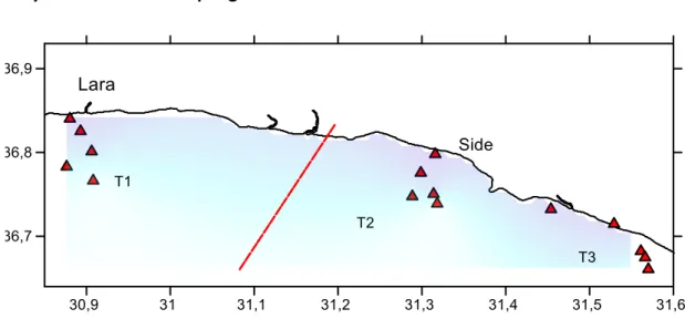
Fig. 2.1: The study area showing the stations and transects over the basic sampling scheme (Surfer 12-Golden software).
The study area encompassed a strip of coast in the north-eastern part of Antalya Gulf. Sampling stations were located along a range of depth extending from 10 to 200 m over the inner portion of the continental shelf. Samples were collected over 6-10 consecutive days in four different seasons covering a period of a year: May, August, October 2014 and February 2015. For each cruise three transects have been considered over two different regions: one transect was located in the Lara-Side region opened to fisheries while two were in the Gașipasa-Side protected area (Fig. 2.1). There were 5 fixed trawling stations for each transect, located at 10-25-75-125-200 m depth. All sampling was conducted during daylight hours between sunrise and sunset. Effort was equally distributed among seasons and all stations were visited during every cruise. A total amount of 79 hauls were performed over all the study.
15 2.2. Trawling
Resources were sampled on board R/V “Akdeniz Su”, 26,5m length, of the Fisheries Faculty of Akdeniz University. In all the fish samplings the same gear was used: a polyethylene bottom trawl net with 44 mm mesh size.
During the hauls, towing speed varied around 2.5 knots, and towing duration was limited to 30 minutes. The starting time and coordinates of the haul were recorded as the moment when the warp was tightened and towing started. The end of the haul was registered as the moment of the beginning of warp hauling. The exact location of sampling hauls for the starting of the operation was found when the desired depth was observed from the echo sounder.
16 2.3. Deck work
2.3.1. Environmental parameters
The environmental parameters considered in this study (Tab. 2.1) include the collection of physical, chemical, biological and geological data. All the parameters have been generally collected just before the sampling or at the end of the trawl operation.
Tab. 2.1: List of the environmental parameters considered in the study with their respective unit measure and abbreviations used in the analysis. Surface water: SSx, Subsurface water: SuSx, Near Bottom water: NBx.
Physical-chemical parameters Biological parameters
Secchi disk depth (m); Secchi Seston - 1 mm (g); Se1
Oxygen (mg/L); SSOx, SuOx, NBOx Seston - 0,5 mm (g); S2 Temperature (°C); SST, SuT, NBT Seston - 0,063 mm (g); S3 Salinity (PSU); SSS, SuSS, NBS Bioseston - 1 mm (g); Bi1
pH; SSpH, SuSpH, NBpH Bioseston - 0,5 mm (g); Bi2
Conductivity (S/m); SSC, SuSC, NBC Bioseston - 0,063 mm (g); Bi3 Density, sigma-t; SSD, SuSD, NBD Tripton - 1mm (g); Tr1 Total Suspended Matter (mg/mL); STSM, SuTSM, NBTSM Tripton - 0,5mm (g); Tr2 Chl-a (mg/mL); SSChl, SuSChl, NBChl Tripton - 0,063mm (g); Tr3
2.3.1.1. Physical parameters
Secchi disk depth: The Secchi disk is a plain white circular disk of 30 cm in diameter used to measure the transparency of the water. The disk is slowly lowered by hand into the water column until the reflectance equals the intensity of light backscattered from the water and it is no longer visible. The distance at which the disk disappears from the sight, called the Secchi depth, is taken as a measure of transparency. It is related to water turbidity and can be affected by the colour of the water, algae, and suspended sediments.
Water temperature, salinity, density, dissolved oxygen, pH: the values of water temperature, salinity, dissolved oxygen, pH, and conductivity have been recorded for each station at the surface, subsurface and bottom depth. The water samples have been sampled through a
17
polyethylene Nansen bottle lowered on a cable to the appropriate depth. Once collected, seawater was immediately analyzed through a portable multi-parameter probe provided with three sensors: a pH electrode, a dissolved oxygen sensor and a conductivity cell.
2.3.1.2. Chemical parameters
Total suspended material: Seawater collected through the Nansen bottle was used to determine the suspended material at surface, subsurface and bottom depth. One litre of water was filtered onto GF/D 25 mm glass fibre filters through a vacuum pump and stored in the freezer for laboratory analysis.
Chlorophyll a: Samples were taken from three different depths from each station trough a Nansen bottle: at 1 meter depth, at the maximum depth where the Secchi disk disappears from sight, and near the bottom for the shallow depth stations or until 75 m for the deepest ones. One litre of seawater was filtered through Whatman GF/F filters (with a 0.7 mm pore size and 47 mm diameter) using a vacuum of less than 0.5 atm. The filters were stored in a freezer until laboratory analysis.
2.3.1.3. Biological parameters
Zooplankton samples were collected by means of a Nansen Closing Net (100 m mesh size and (0.57/2)²π mouth opening area) with messenger-operated closing mechanism. The open net was brought to the greatest scheduled depth and the sample was concentrated inside a metal collecting bucket with side window covered with sieve gauze. At the end of the tow, the outer side of the net was sprayed down with surface seawater to concentrate the organisms in the collecting bucket. The sample was size-fractionated through a sieve series (1, 0.5, 0.063 mm) and each size fraction was filtered on board onto GF/D 25 mm glass fibre filters through a vacuum pump (Fig. 2.3). Samples were frozen until laboratory processing.
18
Fig. 2.3: Organisms and non-living matter obtained after seawater filtration on board.
2.3.2. Fish collection
For each trawl the material caught was separated: fish, benthic organisms, no-living organic and inorganic materials such litters and garbage. The fishes were sorted and identified to species or occasionally to higher taxonomic level. Then the total weight was measured for each species. Very large samples were subsampled by weight for some abundant species according to the fish size (1/3 for large size and 1/6 for small size). Total number amount of fish was then estimated from the abundance of subsample. For cartilaginous fishes morphometric parameters, weight and sex were determined individually on board before being thrown back into the sea. The remaining fish was preserved with 5% formaldehyde and stored for laboratory analysis.
Litter was sorted and weighted according to the material properties (metal, nylon, plastic, etc.) and then stored to be disposed ashore.
19 2.4. Laboratory work
2.4.1. Environmental parameters 2.4.1.1. Chemical parameters
Total suspended material: In laboratory samples were defrosted at room temperature. Each filter was dried in an oven at 60 °C for 24 hours and weighted on an analytical balance (Radawak A220) for determination of the dry weight.
Chlorophyll a: Chlorophyll measurements were made with acetone extraction method. Filters were homogenized in 10 mL of 90% acetone solution and maintained in the dark and cold. After 24 h, samples were centrifuged and absorbance was subsequently measured at 665 645 630 nm wavelength at spectrophotometer. The filtered samples were bleached with a solution of 90 % acetone at 750 nm. Final Chl-a (mg/mL) value was calculated dividing by the volume of the filtered seawater according to the equation:
Chla (mg/mL)= ( 11,85 A665 - 1,54 A645 - 0,08 A630)*V * I-1 *V7
Where: V=aceton volume (mL), V= filtered water (mL), I= cell length cm, A= absorbance
2.4.1.2. Biological parameters
Samples were defrosted at room temperature. Each filter (which represents a single size-fraction of the tow) was dried in an oven at 60 °C for 24 hours and weighted on the analytical balance Radwak AS220 for determination of the dry weight. The filters then were ashed in a muffle furnace at 500 °C for 5-6 hours, and reweighed for ash. Three aliquots of filtered seawater were treated as above for blanks determination. The mean dry weight blank was subtracted from the measured dry weights for determination of the total organic and non-living matter (Seston). The ash weight, which represents the inorganic fraction (Tripton), was subtracted from the dry weight for determination of the organic fraction (Bioseston).
20 2.4.1.2. Geological parameters
The information about bottom types, bottom sediments and aquatic plants is encoded in the echo signal of the echosounder, stored and acquired simultaneously with GPS data. During surveys different echoes can be observed on the oscilloscope and echogram of the echosounder when sampling hard or soft bottom. Hard bottom will produce a sharp bottom echo with high amplitude while a soft bottom will produce an elongated echo with lower amplitude. In order to classify the different bottom types the Fractal dimension method implemented in BioSonics Bottom Classifier VBT was used in this study. In the VBT software, the Fractal Dimension is a measure of the irregularity of an echo envelope obtained from the bottom. By classifying the echo envelope in terms of its fractal dimension, we define the shape of the envelope by associating it with a FD number. Since the echo envelopes associated with different bottom types show regularities in shape, one can expect that we can classify the bottom echo in terms of FD. Different bottom categories are colour coded at the same time and displayed on the map with the location of each VBT report acquired with GPS data.
2.4.2. Fish analysis
In the laboratory species identification was checked by the Mediterranee et mer Noire Volume II (Fischer, 1973) and for Lessepsian species by the Atlas of Exotic Species in the Mediterranean on the CIESM website. For each specimen total length (TL, ± 0.01 cm) was recorded and after being dried with paper total weight was measured with the digital balance Precisa XB620M (W, ± 0.01 g). For each individual sex was determined according to dimension and macroscopic aspects (vascularization, eggs or sperm visibility, color) of gonads. Specimens whose sex determination was not possible because badly decomposed or deformed were classified as “not identified”.
21 2.5. Statistical analysis
2.5.1. Preliminary work
Raw data values of abundance and biomass from the field work were standardized according to the swept area of the different stations. The swept area was estimated from:
A=D*hr*X2
where D is the distance covered by the trawl over the ground when trawling, calculated from acoustic lines, and X2 is the fraction of the head-rope length, hr, which is equal to the width of the path swept by the trawl, the wing spread hr*X2. A value of 0.5 was chosen for X2 according to the model of the trawl as suggested by Pauly (1980). The catch per unit area (CPUA) was then estimated by dividing the catch by the swept area (in squared km) obtaining abundance per unit area (N / km2) and biomass per unit area (kg / Km2).
Standardized data have been organized over two different matrices for abundance and biomass with the list of the fish species as first column and the sampling stations as first row. Information used to classify the diet of adults for each species was obtained from FAO species identification sheets (Fisher et al., 1987) and from FISHBASE (ICLARM. http.//www.fishbase.org), to broaden our fish species codification to be consistent with trophic considerations. First of all, flatfishes and bottom dwellers whose habits depend entirely on the ground were excluded. “Semidemersal” fishes were classified as those species, mainly zooplanktivorous, living above the seafloor. These species can play a crucial role in the flux of energy from low to high trophic levels of benthic and pelagic food webs being preyed by larger demersal and pelagic fishes. “SD” abbreviation was used to group all those fish species which are generally considered demersal in habits but that can tear away from the bottom in some part of the day or can feed on the same resources of semidemersals. Some pelagic species have been also found. In this study a comparison was made between the semidemersal species and the whole community constituted by the all SD and semidemersal fishes.
22 2.5.2. Numerical indices
The qualitative and comparative descriptions among the species in the whole area were based on the following three numerical indices (Holden and Raitt 1974):
- Dominance (D%): occurrence percentage of each species among stations;
- Frequency of occurrence (FO%): occurrence percentage of each species among the total frequency of occurrence of all species in the study area;
-Numerical occurrence (NO%): occurrence percentage of each species among the total abundance/biomass of all species in the whole study area.
According to the Soyer’s Index and to the Dominance values the species were classified as follow over the study area: D<25% rare, 25%<D<50% common, D>50% constant.
2.5.3. Target species
Selection of the target species was made considering their ecological and economical importance and the order of numerical indices. The same analysis for the determination of the main morphometric relationships, sex ratio and length-frequency distribution were applied for each species.
The length-weight relationship for fishes is expressed by the equation W=aLb where W is the
total weight, L is the total length, and a and b are parameters estimated by linear regression of logarithmically transformed length-weight data (Ricker, 1973). In general, a b value lower than 3.0 represents fish that become less rotund as length increases and a b value higher than 3.0 represents fish that become more rotund as length increases. When b is equal to 3.0, growth may be isometric meaning that the shape does not change as fish grows (Anderson and Neumann, 1996). The degree of association between the variables length and weight was computed by the determination coefficient, r². Student’s t test was used to find out whether the coefficient b was significantly different from 3 (H°: b = 3). In this case
23
growth can show negative allometry (b < 3) or positive allometry (b > 3). Regression curves were determined by IBM SPSS 21 software.
The sex ratio is expressed as the proportion of the different sexes from the pooled data. Statistical differences between changes in the number of females and males were determined using the chi-square test. The chi-square test shows if there is significant deviation from the expected ratio of 1:1.
The pooled length measures, standardized for each station according to subsample, were counted for length-frequencies. The length-frequency distributions were then separated into cohorts and an arbitrary age was assigned to each of those cohorts by means of Bhattacharya’s Method in FISAT_II software (FAO-ICLARM Fish Stock Assessment Tools, VERSION 1.2.0).The optimal class interval was determined through the COST function.
2.5.4. Faunistic characteristics
The abundance and biomass values and the diversity indices were calculated for each station for both semidemersal and the combined species. The following diversity indices were considered:
- S: Species richness - d: Margalef’s index - J’: Pielou’s evenness index
- H’: Shannon-Winer diversity index
Three-way ANOVA was undertaken to test the differences in each number of species, abundance, biomass and the diversity indices among season, depth and the transects at
24 2.5.5. Assemblage structure: tests and ordinations
We used multivariate statistical tests to search for patterns of community structure in space and time for both the all fishes and the semidemersal species. PRIMER analytical software (vers. 6.1.6, PRIMER-E Ltd, Plymouth, U.K.) with PERMANOVA+ (Anderson et al., 2008) was used for all multivariate routines.
2.5.5.1. Permutational analysis of variance (PERMANOVA)
We first tested for differences among main effects (seasons, transects and depth) and interaction terms by using a type-III permutational multivariate analysis of variance (PERMANOVA) in a three-way crossed design. PERMANOVA is a semiparametric group difference test directly analogous to multivariate analysis of variance but with pseudo-F ratios and P-values generated by resampling (permutation) the resemblance measures of the data; thus it is less sensitive to assumptions of parametric tests that are frequently violated by community data sets (Anderson et al., 2008). For all biotic data we used the Bray-Curtis coefficient to construct resemblance matrices. Transects and depths were treated as fixed effects: the examination and testing of variations in community structure between transects and depths was the a priori objective of the study. Seasons were treated as random effects because there was no a priori reason for the timing of the study. After this global test, pairwise comparisons were made between the levels of each significant factor.
2.5.5.2. Species clustering and ordination
Cluster analysis and non-metric multidimensional scaling (MDS), were applied to create graphical summaries of relationships among samples and to highlight geographical patterns in fish assemblage composition. MDS constructs a map of the samples in a specified number of dimensions and operates on the rank orders of the elements in the resemblance matrix, rather than on the resemblance matrix itself. A stress value ranging from 0 to 1.0 is used to
25
measure the reliability of the ordination, with zero indicating a perfect fit and with values >0.3 indicating that points are close to being arbitrarily placed in the graph.
2.5.5.3. Representative species
Where group differences in community structure were found, we used another exploratory method to identify those species most responsible for the difference. For any two groups, SIMPER (similarity percentages) calculates the percent contribution each species makes to the total between group dissimilarity (Clarke and Warwick, 2001). SIMPER identifies a small subset of species that are more consistently present or more abundant in one group than another, thus helping to reveal the major contributors to each group’s biotic identity and simplifying the interpretation of community patterns.
2.5.6. Relations between biotic and environmental variables
2.5.6.1. BIO-ENV analysis
The multivariate non-parametric technique BIO-ENV, implemented in the PRIMER analytical
software (vers. 6.1.6, PRIMER-E Ltd, Plymouth, U.K.) with PERMANOVA+ (Anderson et al., 2008), was applied to assess the potential matches between environmental variables and the species composition of sampling sites. In this approach, a triangular resemblance matrix was first created for each group of fish using abundance and biomass normalized data and Euclidean distance. BIO-ENV attempts to find the best combination of environmental variables that maximize the match, measured using Spearman rank correlation (r) between sites in terms of their species composition and environmental gradient. Significance of the rank correlation was determined using permutation testing.
26 2.5.6.2. Canonical analysis
Multivariate analysis was also undertaken using the method of canonical correlation (CanCorr) in the Canoco for windows 4.5 statistical package. This approach seeks to find linear combinations of explanatory variables (the environmental parameters) and response variables (the various measures of abundance and biomass of fishes) along canonical axes.
All fish abundance were log-transformed (log10(B+1)) prior to the analysis. A matrix of the
explanatory variables was used to quantify variation in the matrix of response variables.
This method also provides some measures of statistical significance in terms of the canonical relationships among variables.
27
3. RESULTS
3.1. Environmental parameters3.1.1 Physical, chemical, biological characteristics
Annual sea surface water temperature (SST) was found 22.79 ± 4.65 °C, with maximum values in August (29.72 ± 1.01 °C) followed by October and May months (24.26 ± 1.05 and 21.29 ± 1.00 °C respectively) and reaching the minimum values in February (16.7 ± 0.74 °C) as shown in Figure 3.1. At increasing depths seawater gets colder but the seasonal changes are still respected. The average subsurface water temperature (SSuT) and near bottom water temperature (NBT) were found 22.4 ± 4.16 °C and 21.06 ± 3.45 °C respectively. The only exception was February, with higher temperature for SSuT and NBT than the SST (17.34 ±0.48 °C and 17.29 ± 0.37 °C respectively). In general sea surface at 10 and 25 m was less salty than off-shore, with an annual average of 39.02 ± 3.00 PSU. May had the lowest SSS values (38.46 ± 1.52). To be noticed that at 25 meter, in proximities of the third transect, stations had the lowest salinity regardless of the sampling season, with values around 28.5 PSU (Fig.3.3). Down to greater depths salinity values increased and were found more stable: SSuS and NBS were found 39.87 ± 1.28 PSU and 39.91 ± 0.52 respectively.
Sea surface oxygen was found around 8.61 ± 0.73 mg/L concentration overall the year, with a slight increase nearing to the bottom. Annual chlorophyll surface concentration was found 1.51 ± 1.46 mg/mL, with the highest values off-shore at 125 and 200 m. This concentration decreases with depth, reaching near the bottom an annual concentration of 0.78 ± 1.22 mg/mL. All zooplanktonic fractions decreased with depth, especially the 0,063 mm size that was 0.0041 ± 0.0017 g at 10 m reaching a concentration of 0.0009 ± 0.0003 at 200 m (Fig. 3.2). February had the highest values in concentration, decreasing gradually during the year. Interesting that the highest concentration was found along the third transect. Total suspended matter had the maximum values at the sub-surface strata (0.270 ± 0.26) and highest concentrations were found in May and near the coast. Secchi disk revealed that the water was more transparent in August and October, especially at 125 and 200 m (Fig. 3.4).
28
Fig. 3.1: Average Surface seawater Temperature (SST) in the study area during the different seasons (Surfer 12 - Golden software).
29
Fig. 3.2: Annual Bioseston (1, 0.5, 0.063 fractions) concentration over the study area (Surfer 12 - Golden software).
30 0 5 10 15 20 25 30 35 40 10 25 75 125 200 10 25 75 125 200 10 25 75 125 200 February October May aug
Fig. 3.3: Annual sea surface water salinity (SSS) in the study area (Surfer 12 - Golden software).
Fig. 3.4: Secchi depth measured over the different seasons (x-axis: sampling stations depths; y-axis: column water depth).
31 3.1.2. Seabed classification
Fig. 3.5: The study area showing the different bottom types from the acoustic-survey lines, during all the cruises: Fine sandy mud; Mud; Sand; Coarse muddy sand; rocks covered by Poseidonia; Lost bottom.
According to the acoustic results, five main bottom classes were identified in the study area corresponding to the predominant sediment type: mud, fine sandy mud, sand, coarse muddy sand and rocks covered by Posidonia (Fig. 3.5). The bottom type changes along the bathymetric gradient. At shallow depths, near the coast, a continuous strip of sand occurs, occasionally followed by some coarse muddy sand strata. In the eastern part, the superficial sediment pattern becomes more complex, due to the irregular presence of a rocky ground covered by vegetation. Down to greater depths a muddy bottom predominates, interrupt by fine sandy mud. In general the sea bed shows a quite constant pattern throughout the study period. Only fine sandy mud is unevenly distributed during the different seasons, probably because of the periodical water supply from the inland transporting terrigenous material.
32 3.2. Fish assemblages
3.2.1 Species composition
A total of 76 fish species belonging to 40 families were recorded in the study (Tab. 3.1). According to the feeding type 33 species (43%) were semidemersal, 33 species (43%) were semidemersal-demersal, 10 species (14%) were pelagic fish. Considering the different zoogeographical affinity of fishes, 48 species (63%) were Atlantic-Mediterranean, 22 species (30%) were Indo-Pacific, 4 species (5%) were cosmopolitan and 2 species (2%) were endemic of the Mediterranean.
Tab. 3.1: Fish species collected on the continental shelf of the study area. A-M: Atlantic-Mediterranean, C: Cosmopolitan, IP: Indo-Pacific, M: Mediterranean. SD: semidemersal-demersal.
Family Species Feeding type Origin
Apogonidae Ostorhinchus fasciatus SEMIDEMERSAL IP
Apogonidae Apogon queketti SEMIDEMERSAL IP
Apogonidae Apogon smithii SEMIDEMERSAL IP
Apogonidae Apogonichthyoides pharaonis SEMIDEMERSAL IP
Argentinidae Argentina sphyraena SEMIDEMERSAL A-M
Argentinidae Glossanodon leioglossus SEMIDEMERSAL A-M
Atherinidae Atherina hepsetus SEMIDEMERSAL A-M
Caproidae Capros aper SD A-M
Carangidae Alepes djedaba SEMIDEMERSAL IP
Carangidae Caranx crysos SEMIDEMERSAL A-M
Carangidae Trachurus mediterraneus SEMIDEMERSAL A-M
Carangidae Trachurus trachurus SEMIDEMERSAL A-M
Carangidae Trichiurus lepturus SEMIDEMERSAL C
Carapidae Carapus acus SD M
Carcharhinidae Carcharhinus plumbeus SD M
Centracanthidae Centracanthus cirrus SEMIDEMERSAL A-M
Centracanthidae Spicara maena SEMIDEMERSAL A-M
Centracanthidae Spicara smaris SEMIDEMERSAL A-M
Centriscidae Macroramphosus scolopax SD A-M
Cepolidae Cepola macrophthalma SD A-M
Champsodontidae Champsodon capensis SEMIDEMERSAL IP
Champsodontidae Champsodon nudivittis SEMIDEMERSAL IP
Champsodontidae Champsodon vorax SD IP
Chlorophthalmidae Chlorophthalmus agassizi SD C
Clupeidae Alosa fallax PELAGIC A-M
Clupeidae Herklotsichthys punctatus PELAGIC IP
Clupeidae Sardina pilchardus PELAGIC A-M
Clupeidae Sardinella aurita PELAGIC A-M
33
Dasyatidae Dasyatis centroura SD A-M
Dasyatidae Dasyatis pastinaca SD A-M
Dussumieriidae Etrumeus teres SEMIDEMERSAL A-M
Engraulidae Engraulis encrasicolus PELAGIC A-M
Fistulariidae Fistularia commersonii SEMIDEMERSAL IP
Haemulidae Pomadasys incisus SEMIDEMERSAL A-M
Haemulidae Pomadasys stridens SEMIDEMERSAL IP
Labridae Pteragogus pelycus SD IP
Leiognathidae Equulites klunzingeri SD IP
Macrouridae Coelorinchus caelorhincus SEMIDEMERSAL A-M
Macrouridae Hymenocephalus italicus SEMIDEMERSAL A-M
Merlucciidae Merluccius merluccius SD A-M
Mugilidae Liza saliens SEMIDEMERSAL A-M
Mullidae Mullus surmuletus SD A-M
Mullidae Upeneus moluccensis SD IP
Mullidae Upeneus pori SD IP
Myliobatidae Pteromylaeus bovinus SD A-M
Nemipteridae Nemipterus randalli SD IP
Rajidae Raja asterias SD A-M
Rajidae Raja clavata SD A-M
Rajidae Raja miraletus SD A-M
Rajidae Raja oxyrinchus SD A-M
Scaridae Sparisoma cretense SD A-M
Scombridae Scomber japonicus PELAGIC IP
Sebastidae Helicolenus dactylopterus SD A-M
Serranidae Anthias anthias SEMIDEMERSAL A-M
Serranidae Epinephelus aeneus SD A-M
Serranidae Epinephelus haifensis SD A-M
Siganidae Siganus rivulatus SEMIDEMERSAL IP
Sillaginidae Sillago suezensis SD IP
Sparidae Dentex dentex SEMIDEMERSAL A-M
Sparidae Dentex macrophthalmus SEMIDEMERSAL A-M
Sparidae Dentex maroccanus SEMIDEMERSAL A-M
Sparidae Diplodus annularis SD A-M
Sparidae Diplodus vulgaris SD A-M
Sparidae Lithognathus mormyrus SD A-M
Sparidae Pagellus acarne SEMIDEMERSAL A-M
Sparidae Sparus aurata SD A-M
Sphyraenidae Sphyraena chrysotaenia PELAGIC IP
Sphyraenidae Sphyraena sphyraena PELAGIC A-M
Sphyraenidae Sphyraena viridensis PELAGIC A-M
Synodontidae Saurida undosquamis SEMIDEMERSAL IP
Synodontidae Synodus saurus SEMIDEMERSAL A-M
Terapontidae Pelates quadrilineatus SD IP
Trachichthyidae Hoplostethus mediterraneus SD C
Trichiuridae Lepidopus caudatus SD A-M
34 3.2.2. Numerical indices
Constant and common fish species identified in the study area according to Soyer index (D%) are given in the table 3.2. The constant species, over 50% in Dominance, are Upeneus moluccensis, Spicara smaris, Saurida undosquamis. The first two species have high NO% for both biomass and abundance. Saurida undosquamis has NO% high for biomass and low for abundance which means occurrence of relatively few individuals but large in size. Among the common species ones with the highest dominance value are Pagellus acarne, Macroramphosus scolopax and Spicara maena.
Tab. 3.2: List of the dominant and common species according to numerical indices: Dominance D%, Frequency of Occurrence FO%, Numerical Occurrence for biomass NO%(B) and Numerical Occurrence for abundance NO%(A).
Species Feeding type D% FO% NO%(B) NO%(A)
Upeneus moluccensis SD 67.09 6.02 4.87 5.62
Spicara smaris SEMIDEMERSAL 60.76 5.45 7.25 5.33
Saurida undosquamis SEMIDEMERSAL 53.16 4.77 3.97 0.93
Pagellus acarne SEMIDEMERSAL 43.04 3.86 5.77 5.22
Macroramphosus scolopax SD 40.51 3.63 0.85 5.18
Spicara maena SEMIDEMERSAL 39.24 3.52 1.81 0.81
Merluccius merluccius SD 35.44 3.18 1.96 0.52
Upeneus pori SD 35.44 3.18 4.06 5.33
Trachurus mediterraneus SEMIDEMERSAL 34.18 3.06 0.54 0.44
Dasyatis pastinaca SD 32.91 2.95 12.14 0.19
Argentina sphyraena SEMIDEMERSAL 31.65 2.84 3.29 8.84
Equulites kluzingeri SD 31.65 2.84 2.27 7.69
Nemipterus randalli SD 31.65 2.84 0.86 0.48
Fistularia commersonii SEMIDEMERSAL 29.11 2.61 0.38 0.50
Dentex maroccanus SEMIDEMERSAL 27.85 2.50 13.56 10.47
Epinephelus aeneus SD 27.85 2.50 1.74 0.37
Diplodus annularis SD 25.32 2.27 2.83 2.83
Lithognathus mormyrus SD 25.32 2.27 2.88 1.79
Raja clavata SD 25.32 2.27 4.32 0.32
35 3.2.3. Target species
Selection of the following species was made according to their ecological and economical importance and to the order of dominance and frequency of occurrence over the study area. 3.2.3.1. Spicara smaris (Linnaeus, 1758)
Spicara smaris was found all over the 10-200 m range depth, with the highest mean biomass values occurring at around 75 - 125 m depth (Fig. 3.6).
Fig.3.6: Spicara smaris: average biomass distribution (kg/Km²) at the different sampling stations over all the seasons (Surfer 12 - Golden software).
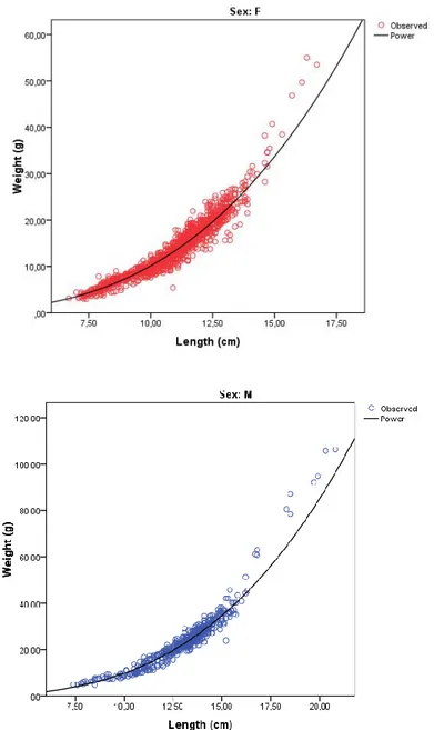
A total of 2,272 individuals ranging from about 6 to 16 cm total length were measured in laboratory. Among them 1,324 were females; 464 were males; 253 were hermaphrodites and 231 were not identified. The total length of males ranged from 8.0 to 20.8 cm, with a mean of 13.1 ± 1.9 cm, and females ranged from 7.0 to 16.7 cm with a mean of 10.9 ± 1.7 hermaphrodites ranged from 9.80 to 15.6 with a mean of 12.5 ± 1.2 cm. The exponent of the length-weight relationship calculated for females and males (Fig. 3.7) is significantly different from the 3 value (P < 0.05) for both sexes, showing allometric negative growth for females (b=2.97± 0.02) and allometric positive growth for males (b=3.12 ± 0.03).
36
Fig. 3.7: Spicara smaris: Regression curves for length-weight relationship estimation: W=0.0076TL3.1377 for females (above) and W=0.0063TL3.1886 for males (below) calculated by BM SPSS
21 software.
The sex-ratio of the samples was calculated as 1:2.85 in a strong favor of females and the chi-square (p<0.05) test shows that there is a significant deviation from the expected ratio 1:1. A few immature individuals, smaller than 7 cm; were classified as juveniles. The mean length of males is larger than females. Females were observed more frequently than males in the samples and no male was observed in the length classes smaller than 16.7 cm. Above
37
this limit the contribution of males gradually increases while occurrence of females gets smaller. This trend reflects the proterogynous sexual behavior of this species, as also indicated by the mean total length of the hermaphrodite individuals collocating in between the transition phase from female to male. Seven different classes were found for frequency-length distribution analyzed through Bhattacharya’s Method (Fig. 3.8). The optimal class interval of 0.3 cm was determined according to the COST function. The highest frequency values were found for the 2+ group at 11.5 cm mean total length. The lowest frequency was found for the last 6+ group with a mean total length of 18.9 cm. Separation index is high enough (S.I.>2) to show an appreciable distinction between the classes (Tab. 3.3).
Fig. 3.8: Spicara smaris: Length-frequency distribution for the total number of individuals as cumulated frequencies overall the sampling period (FISAT_II software).
Tab. 3.3: Spicara smaris: Summary of results of the identification of the first seven main modal components for length-frequency distribution using the Battacharya’s method (FISAT_II software).
Group Comp.Mean S.D. Population S.I.
0+ 6.7 0.61 617 n.a 1+ 8.8 0.82 15060 2.19 2+ 11.5 0.89 58753 2.21 3+ 13.5 0.53 19945 2.09 4+ 14.9 0.35 4038 2.07 5+ 15.6 0.32 664 2 6+ 18.9 0.41 544 2.32
38 3.2.3.2. Saurida undosquamis (Richardson, 1848)
The brushtooth lizardfish was found between 10 and 125 m depths, with the highest mean biomass values occurring at around 25 m (Fig. 3.9).
Fig.3.9: Saurida undosquamis: biomass distribution (kg/Km²) at the different sampling stations averaged over all the seasons (Surfer 12 - Golden software).
The length of the 370 individuals caught during the trawl operations ranged between 6 and 34 cm. Among them 231 were females; 111 were males; 4 were juveniles and 24 were not identified. Females ranged between 10.0 – 33.6 cm TL with an average of 24.21 ± 4.4 cm TL while males were between 9.5 and 30.7 cm TL, averaging 18.6 ± 4.1 cm TL.
The slope of the regression equation for length-weight relationship is significantly different from the 3 value (P < 0.05) indicating a positive allometric growth for males (b= 3.09±0.05) while it is not significant for females (b=3.06 ± 0.04) which show isometric growth (Fig. 3.10).
39
Fig. 3.10: Saurida undosquamis: Regression curves for length-weight relationship estimation:
W=0.0053TL3.062for females (above) and W=0.0049TL3.091 for males (below) calculated by the IBM
SPSS 21 software.
The overall sex ratio was 1:2.9 in favor of females and the chi-square (p<0.05) test shows that there is a significant deviation from the expected ratio 1:1. The mean total length size of females seems larger than males one.
40
Frequency-length distribution for a class interval of 0.5 cm given by COST function displays six different groups (Fig. 3.11). The highest number of frequency values was found for the 3+ class at around 23.2 cm mean length (Tab. 3.4).
Fig. 3.11: Saurida undosquamis: Length-frequency distribution for the total number of individuals as cumulated frequencies overall the sampling period (FISAT_II software).
Tab. 3.4: Saurida undosquamis: Summary of results of the identification of the first six main modal components for length-frequency distribution using the Battacharya’s method (FISAT_II software).
Group Comp.Mean S.D. Population S.I.
0+ 8.6 0.72 86 n.a 1+ 13.5 1.12 594 2.67 2+ 19.4 1.33 2196 2.46 3+ 23.2 1.78 2444 2.07 4+ 28.0 1.14 2056 2.15 5+ 32.1 0.26 202 2.18
41 3.2.3.3. Pagellus acarne (Risso, 1827)
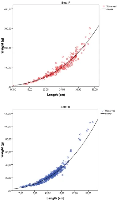
Pagellus acarne was sampled from 10 to 200 meters throughout the study period (Fig. 3.12).
Fig. 3.12: Pagellus acarne: biomass distribution (kg/Km²) at the different sampling stations averaged over all the seasons (Surfer 12 - Golden software).
A number of 1074 individuals ranging from 5 to 20 cm TL was stored for laboratory analyses. Among them 2261 were females; 1914 were males; 54 were juveniles and 264 were not identified. Females of P. acarne ranged between 9.9 and 19.7 cm TL with an average of 14.6±2.1 cm TL. Males were between 8.5 and 19.3 cm TL, averaging 12.0±2.0 cm TL.
The exponent of the length-weight relationship is significantly different from 3 (P < 0.05) for both females and males with b: 3.16 ± 0.5 and b: 3.15 ± 0.2 respectively, indicating a positive allometric growth (Fig. 3.13).
42
Fig. 3.13: Pagellus acarne: Regression curves for length-weight relationship estimation:
W=0.008TL3.157 for females (above) and W=0.008TL3.145 for males (below) calculated by IBM SPSS
21 software.
The sex-ratio of the samples was calculated as 1:0.29 in a strong favor to males. Immature individuals smaller than 8.5 cm could not be sexed, therefore they were classified as juveniles.
43
The mean length and the range of size the males were larger than females. Males were observed more frequently than females in the samples and the contribution of males gradually increases while occurrence of females gets smaller. Indeed this species shows proterandric sequential hermaphroditism.
Frequency-length distribution shows five different groups (Fig. 3.14). The class with the highest number of frequency values was 1+ with a mean total length of 10.6 cm; the lowest frequency value was found for the last group 4+ (Tab. 3.5). The interval class size of 0.3 cm was selected according to COST function.
Fig. 3.14: Pagellus acarne: Length-frequency distribution for the total number of individuals as cumulated frequencies overall the sampling period (FISAT_II software).
Tab. 3.5: Pagellus acarne: Summary of results of the identification of the first six main modal components for length-frequency distribution, using the Battacharya’s method (FISAT_II software).
Group Comp. Mean S.D. Population S.I.
0+ 7.4 1.03 1375 n.a
1+ 10.6 1.15 13795 2.23
2+ 13.4 1.23 9187 2.08
3+ 16.5 0.82 2258 2.14