importante rimane non trascurare cio’ per cui ci troviamo al mondo: gli Af-fetti.
Grazie alla mia famiglia, mio padre Alfio e mia madre Adelaide. Tutto cio’ che sono e’ il risultato dei vostri insegnamenti e sacrifici.
Grazie al mio amore, Valentina, che non si e’ mai stancata di supportarmi con pazienza, caparbieta’ e dolcezza.
1 Introduction to the Internet of Things paradigm 1
1.1 The Internet of Things . . . 1
1.2 IoT Application Domains . . . 5
1.2.1 Smart Cities . . . 6
1.3 Smart City Platforms . . . 8
1.4 Context-Aware Applications . . . 9
1.5 IoT Networks . . . 11
1.5.1 Vehicular Networks . . . 13
1.5.2 Culture of IoT and Smart Museum . . . 16
1.6 Evolution of Communication Technologies . . . 18
1.7 Data Management . . . 20
1.8 Privacy Management . . . 22
1.9 Contributions of the Thesis and Publications . . . 23
2 A Context-Aware Smart Parking System 25 2.1 Smart Parking System Architecture . . . 27
2.1.1 Smartphone and Driver . . . 28
2.1.2 The Engine . . . 30
2.1.3 Application (Presentation Layer) . . . 31
2.1.4 Algorithm to determine occupied parking slots . . . . 32
2.2 Experiments . . . 34
2.3 Results . . . 34
3 Intent-Based Interaction using Smart Cooperative Objects 39 3.1 Related Work in literature . . . 41
3.2 Smart Cooperative Objects Architecture . . . 44
3.3 Proposed Architecture . . . 46
3.3.1 System Architecture . . . 46
3.3.2 Smart Object Structure . . . 47
3.4 Implementation . . . 54
3.4.1 The microclimate management use case . . . 56
3.4.2 Experiments . . . 58
3.4.3 Results . . . 59
4 smARTworks: a Multi-Sided Context-Aware Platform for the SmartMuseum 61 4.0.1 Motivating Example . . . 62 4.1 smARTworks Architecture . . . 63 4.1.1 Sensor Layer . . . 64 4.1.2 Service Layer . . . 64 4.1.3 Engine Layer . . . 65 4.1.4 Presentation Layer . . . 67 4.1.5 Artwork Description . . . 67 4.1.6 Setting of preferences . . . 69 4.2 Results . . . 70
5 BaaS: Mobile Sensor Nodes Network for the Air Quality
Monitor-ing 71
5.1 Related Work in literature . . . 74
5.2 Bus As Sensors Architecture . . . 76
5.2.1 Sensors Layer . . . 77
5.2.2 Platform Layer . . . 79
5.2.3 Middleware . . . 80
5.2.4 Application Layer . . . 82
1.1 Smart City Ecosystem . . . 7
1.2 Communication Technologies Use Cases . . . 20
2.1 Proposed system architecture: sensing (GPS+BLE) and pre-sentation (Smart Parking App) layers reside in smartphones while the Engine component is hosted in an external server. . . 28
2.2 A screenshot of the Smart Parking Android app: the user is requested to confirm the presence of a passanger (in this case Elizabeth) in his vehicle. . . 30
2.3 Algorithm adopted to evaluate the similarity between two dif-ferent paths. . . 36
2.4 Two example paths which have different starting points and sharing the same destination point. . . 37
3.1 Smart Cooperative Objects System Overview . . . 45
3.2 Smart Object Structure. . . 48
3.3 Sequence Diagram of Smart Objects’ discovery . . . 50
3.4 Main App - Configuration of a Smart Object . . . 51
3.5 A use case for the microclimate management . . . 57
3.6 Response Time System in seconds for Case 1 and Case 2 . . . 58
4.1 smARTworks Architecture . . . 63
4.2 HTML Interface as output of DUI . . . 68
5.1 Catania bus lines . . . 72
5.2 BaaS Architecture . . . 76
5.3 Sensor Node Layer - (a) Libelium Smart City Pro, (b) Li-belium Smart Environment Pro, (c) LiLi-belium Meshlium Ex-treme 4.0, (d) Raspberry Pi 3 board . . . 77
5.4 Air Polluntant’s Log-Normal Distribution . . . 79
5.5 BaaS Middleware . . . 80
5.6 Aggregation process example . . . 81
5.7 High Resolution Air Quality map . . . 83
4.1 Artwork’s Attributes . . . 66 4.2 Comparison of main Smart Museum Solutions . . . 70 5.1 Examples of data rows stored on IoT Platform . . . 79
Over the last years, researchers have shown a great interest for Internet of Things (IoT). The evolution of this new paradigm, provides a new “object” concept, in which new relevant technologies enrich ordinary objects with new interesting features which aim to make them Smart. Each object becomes a device able to gather information and react in the surrounding environment.
In accordance with the raise of IoT paradigm, many researchers and com-panies have developed systems and applications that exploit the new smart objects’ technologies to provide customized information and services. In fact, the spread of smart objects in areas/spaces frequented during activities of daily life promote the usage of these services, but, often, is not clear for users which services are available in a specific place at a specific moment.
In order to provide personalized services, IoT applications gather personal data such as preferences, habits, and information about users’ positioning which are part of “User Context”, a relevant concept that has been studied several years ago, and that is treated in the next chapters of this Thesis with the introduction of the Context-Aware Applications.
In particular, the users’ positioning is considered a very relevant concept for the Context-Aware Applications, with several Indoor and Outdoor
ization technologies developed during the last years, such as GPS or Blue-tooth Low Energy(BLE) which allow to collect users’ information within constrained and unconstrained environments (cities, buildings, offices and houses).
The work done during the Ph.D. years focuses on cooperating smart ob-jects in IoT infrastructures that exploit the aforementioned indoor and outdoor localization technologies to provides Context-Aware Applications.
In particular, this Thesis is going to introduce IoT concepts with the works developed during these years which apply IoT Context-Aware concepts in several fields, including smart cities and smart environments.
The first chapter of this thesis introduces the Internet of Things as a new paradigm and as an enhancement for the quality of ordinary peoples’ lives. It aims to highlight the IoT origins and its development through new communi-cation technologies.
Initially, the introduction chapter shows the increase of ordinary objects’ capabilities through the exploitation of IoT concepts, and introduces the ap-plication domains in which these new devices are placed.
The first chapter also introduces the relevant Context concept, the devel-opment of Context-Aware applications to provide customized services within smart environments, the establishment of new IoT networks which have many common points with the traditional networks, and a set of relevant open issues as challenges for the research communities.
The other chapters report a set of works developed during my Ph.D. years which aims to provide customized services in several IoT domains to increase the users’ experiences within a smart environment.
In particular, these works aim to provide solutions for several issues in smart cities (Chapters 2, 5), smart homes and offices (Chapter 3), and smart museums (Chapter 4). The main common objective is to show how the IoT
could represent a value added to the people’s lives.
Peoples have a great interest towards the technologies, and a relevant num-ber of persons is already equipped with smart devices (i.e. smartphones). For this reason, i think that could be a useful to exploit these devices and their sensors for the creation of customized services without the using of expansive infrastructures or additional annoying equipment if their are not necessary.
The Thesis also introduces a more complex and expansive IoT solution i.e. an Air Quality Monitoring System which aims to report the air pollution information through a web application, and gather user’s context information through a mobile application in order to suggest the appropriate places or the appropriate routes (in term of pollution) to reach a destination.
This Ph.D has been financed by Telecom s.p.a. (TIM), and the Ph.D ac-tivities have been conducted within the JOL Catania Lab.
Nel corso degli ultimi anni, i ricercatori hanno mostrato un grande interesse nei confronti dell’ Internet of Things (IoT). L’evoluzione di questo nuovo paradigma porta alla nascita di un nuovo concetto di Oggetto (Object), che grazie alle moderne tecnologie viene arricchito da nuove e interessanti carat-teristiche e funzionalita’ che lo rendono Intelligente (Smart). Da qui il termine Smart Object. Ciascun oggetto diventa un dispositivo capace di raccogliere informazioni e reagire all’ambiente che lo circonda.
Con l’ascesa del paradigma IoT, molti ricercatori e aziende hanno svilup-pato sistemi e applicazioni che sfruttano l’utilizzo dei nuovi Smart Object per fornire servizi personalizzati e informazioni utili.
Infatti, la diffusione di Smart Object all’interno di aree frequentate, pro-muove l’utilizzo di questi servizi, anche se spesso non e’ chiara la loro disponibilita’, dipendente dal tempo e dallo spazio.
Le applicatizioni IoT mirano alla raccolta di informazioni personali, quali preferenze, abitudini, ed informazioni relative alla propria posizione, de-finendo il Contesto (Context) dell’utente, un concetto molto importante, stu-diato diversi anni fa e trattato nei prossimi capitoli mediante l’introduzione delle applicationi Context-Aware.
In particolare, la posizione degli utenti e’ considerata un concetto molto importante per le applicazioni Context-Aware, con diverse tecnologie di lo-calizzazione Indoor e Outdoor realizzate negli ultimi anni, quali GPS o Blue-tooth Low Energy (BLE), permettendo di raccogliere informazioni all’interno di ampi o ristretti ambienti (citta’, edifici, uffici e abitazioni).
Il lavoro svolto durante il mio Dottorato di Ricerca si e’ focalizzato su Smart Object cooperanti all’interno di infrastrutture IoT, sfruttanti le tecnolo-gie indoor e outdoor appena mensionate per la realizzazione di applicazioni Context-Aware.
Questa tesi presentera’ i concetti dell’Internet of Things e diverse ques-tioni ancora irrisolte, o parzialmente risolte, insieme ai lavori sviluppati du-rante questi anni, nei quali ho cercato di applicare i concetti dell’IoT in diversi ambiti quali Citta’ Intelligenti (Smart Cities) ed Ambienti Intelligenti (Smart Environment).
Il primo capitolo di questa tesi introdurra’ l’Internet of Things come nuovo paradigma ed miglioramento della qualita’ della vita. Verranno messe in ev-idenza le origini dell’IoT e il suo sviluppo attraverso l’introduzione di nuove tecnologie.
Questo capitolo introduttivo mostrera’ l’incremento delle capacita’ degli oggetti ordinari attraverso l’utilizzo dei concetti dell’IoT, e presentera’ diversi domini applicativi in cui questi dispositivi vengono posti.
Inoltre, il primo capitolo introdurra’ l’importante concetto di Context, lo sviluppo delle applicazioni Context-Aware per la realizzazione di servizi per-sonalizzati all’interno degli ambienti smart, la realizzazione di reti IoT che presentano molti punti in comune con le reti informatiche tradizionali, ed un insieme di problematiche ancora aperte che rappresentano sfide per la comu-nita’ di ricerca.
l’attivita’ di Dottorato di Ricerca, e che hanno come obiettivo la copertura di diversi domini IoT fornendo servizi in grado di aumentare l’esperienza utente all’interno degli ambienti smart.
Questi lavori hanno l’obiettivo di fornire soluzioni per citta’ (Capitolo 2, 5), abitazioni e uffici (Capitolo 3), e musei (Chapter 4). L’obiettivo comune e’ mostrare come l’IoT possa rappresentare un valore aggiunto nella vita delle persone.
Le persone hanno mostrato un grande interesse nei confronti della tac-nologia, ed un numero non indifferente di utenti sono gia’ forniti da una se-rie di dispositivi smart (come gli smartphone). Per questo motivo, penso sia molto utile sfruttare questi dispositi ed i loro sensori per la realizzazione e la personalizzazione di servizi, senza la necessita’ di utilizzare ulteriori costose infrastrutture, o fastidiosi sensori addizionali.
Infine, questa Tesi introdurra’ un sistema maggiormente complesso e cos-toso, ovvero un sistema per il monitoraggio della qualita’ dell’aria, che ha come obiettivo quello di realizzare un report dell’inquinamento attraverso un applicazione web, raccogliendo informazioni di contesto dell’utente per fornire dei consigli su quali strade utilizzare o quali posti raggiungere evi-tando l’inquinamento.
Questo dottorato di ricerca e’ stato finanziato da Telecom s.p.a (TIM), e le attivita’ di ricerca di sono svolte presso il JOL Catania Lab.
I wish to express my sincere thanks to all those who supported me in this very relevant experience.
Foremost, I would like to express my gratitude to my Advisor Prof. Vin-cenzo Catania for the support of my Ph.D study and research.
Besides my Advisor, I wish to express my thanks to my Co-Advisors/Tutors, Ing. Salvatore Monteleone and Ing. Giuseppe La Torre for the help provided in these years.
I would like to thank the Telecom Italia s.p.a. (TIM) for the financial support provided during these year, and in particular, i wish to express my gratitude to the Ing. Valeria D’Amico, and all members of TIM JOL catania lab.
Last but not least, i would to express my gratitude to my family, to my Father and my Mother with my Girlfriend Valentina which were close to me during the entire period. Thanks.
ONE
INTRODUCTION TO THE INTERNET OF
THINGS PARADIGM
1.1
The Internet of Things
The development of computer networks, Internet Protocol and communica-tion technologies brings to a new mobile-oriented connected world. These technologies, with others, are widely exploited for the implementations of concepts concerning to a new paradigm called Internet of Things (IoT) [1–3]. This term was first documented by British visionary Kevin Ashton in 1999. In particular, he used IoT term to describe a system where the Internet con-nects to the “real world” via a ubiquitous network of data sensors. The origin of IoT has been attributed to members of the Auto-ID Center at MIT, the de-velopment community of the Radio-Frequency Identification (RFID), around 2000.
The RFID is a technology that allows ordinary objects to be uniquely
tified by “smart tags” [4] which are able to store small quantities of data. In line with the RFID technology, the members of the Auto-ID Center aimed to discover information about a tagged object through an internet address or a database entry related to a particular RFID. In this way, each physical object can be identified through the recognition of a universal identify (like a URI).
Today, the concept of Thing is more general and is not limited to RFID only, but it is widely exploited into the research world, and it is subjected to novel interpretations in which different aspects and technologies are com-bined: Internet Protocol, Sensing and Communication Technologies, Ubiq-uitous computing, Pervasive computing, and embedded devices. Thus, the IoT brings to a new vision for data exchange and computation that is oppo-site to the traditional paradigms for data acquisition, that include the ordinary computer networks.
Then, the union of the Internet and new emerging technologies lets us transform everyday objects into smart objects able to obtain knowledge and react in their environments [5]. These “Smart Objects”(SOs) are the building blocks of IoT paradigm: everyday objects turn into smart objects through the addition of intelligence in order to collect environment information, and interact with physical world or with other smart objects to share or exchange data information. In addition to these features, each smart object could be able to provide computational capability, collaborate with other smart object to reach specific objectives, and change their positions in order to create a mobile network able to cover a large operation area.
The smart objects acquire a relevant importance into the people’s life, in which, the IoT play an active role with a huge number of interconnected de-vices that provide useful serde-vices which aim to elaborate a significant amount of available data.
key differences in smart objects designs can be found along the following three design dimensions [5]:
• Awareness, which is the smart object’s ability to understand (sense, in-terpret, and react to) events and human activities occurring in the phys-ical world.
• Representation, refers to a smart object’s application and programming model (programming abstractions).
• Interaction, which denotes the object’s ability to converse with the user in terms of input, output, control, and feedback.
Thus, smart devices are extremely heterogeneous in terms of resource ca-pabilities and communication technologies. For example, the modern smart-phones and tablets are a particular smart devices equipped with a significant computation capability and a set of sensors able to interact with the sur-rounding environment. In particular, smartphones and other smart objects are equipped with several electronic modules for internet connectivity. In fact, Internet is the core of IoT, and it allows to introduce new computations ways rather than traditional computation systems. In line with these concepts, the Cloud provides the abstraction of a set of computers, offering computation and storage services.
Although the smart objects are very heterogeneous, the most useful de-signs involves three main object types:
• Activity-Aware Smart Objects: An activity-aware object can record information about work activities and its own use. In particular, these objects are able to understand the world in terms of event and activity streams that are directly related to the use of them self. Furthermore,
activity-aware objects already support relevant applications. Techni-cally, an activity-aware smart object should analyze the data gathered from its sensors, and applies several recognition algorithms in order to detect activities and events.
• Policy-Aware Smart Objects: A policy-aware object is an particular activity-aware object which is able to interpret events and activities with respect to predefined organizational policies. Furthermore, these ob-jects provide context-sensitive information to raise warnings and alerts if the policies are infringed.
• Process-Aware Smart Objects: These smart objects have a relevant role in industrial work management and operation. A process-aware object provides workers with context-aware guidance about tasks, dead-lines, and decisions.
Despite the benefits described above, relevant open issues affect the new IoT systems and architectures.
In particular, security and privacy represent the main challenges: the dy-namic nature of networks, and the capabilities of devices to collect personal information and share data among their could produce high risks for confi-dential data leaks. Furthermore, smart devices could be subjected to direct attacks aimed to retrieve users’ information, or to alter important data that could cause inappropriate operation modes.
The following sections aim to describe the main IoT application domains and open issues that need solutions.
1.2
IoT Application Domains
During the last years, the IoT has rapidly covered many application heteroge-neous domains:
• Building automation, Smart home and Smart environment, which aim to automate many systems like Heating, Ventilating, Air Condition-ing, Lighting to improve the comfort with a particular attention for the energy consumption.
• Smart cities, that represents a large sector that involves the use of dig-ital technologies to improve the provided services within the cities. In particular, smart cities aim to provide smart services within transport, energy, health care, water, waste management, and air pollution moni-toring fields.
• Smart agriculture, which includes smart irrigation applications. • Health IoT applications that include devices able to monitor personal
activities (e.g.calories burned, number of steps for a day etc.) to pro-mote a regular lifestyle, or to give indications about the health condi-tions of people. In general, these devices are “wearable” and they are equipped with a set of sensors and a moderate computation capability which allows to send information to external services in order to store and manage them-self. Furthermore, these stored information could be consulted and analyzed whenever possible.
• Remote monitoring for patient monitoring, smart grid, pipeline sen-sors, and desktop/server monitoring.
• Industrial automation which involves the use of various control sys-tems aimed to reduce human intervention.
• Transportation and logistics domain in which cars, trains, buses, and bicycles are becoming more instrumented with sensors, actuators, and processing power [1]. Furthermore, roads are also equipped with tags and sensors which aim to send information about the traffic and trans-portation vehicles. Then, vehicles includes various systems to enhance the security, promote the exchange of relevant information, and auto-mate the guide.
• Smart museum which includes various systems to improve the mu-seum experience.
1.2.1
Smart Cities
The smart city is considered a relevant domain and a concrete implementa-tion of IoT paradigm, which allows to create an ecosystem of persons, smart objects, and resources. The increasing of population, vehicles, and resources consumed (e.g., light, water, clear air) produces a deterioration of quality, sustainability and security of the cities. In order to improve the sustainabil-ity and the secursustainabil-ity of cities, and then of citizens, the IoT provides solutions that guarantee to optimize the use of the available resources, the reduction of pollution through a restriction of CO2emissions and other pollutants, and the
increasing of life quality. So, the smart city concepts aim to provides ecosys-tems (Fig. 1.1) able to manage a set of services through the widespread usage of Information and Communication technologies (ICT).
Frequently, the introduction of IoT in a traditional city, causes the use of a large amount of sensors, or smart objects that gather information or change
Figure 1.1: Smart City Ecosystem
environments’ conditions: for example, the use of smart sensor for cities’ lights to realize a smart managing for reducing the energy consuming, the traf-fic (reducing of traftraf-fic through a real time managing of semaphores, and the proposition of alternative routes), the accidents and critical situations (through a set of messages shared between the vehicles that could raise alert signals).
In the mean time, the use of a large number of sensors placed within the cities and vehicles also allows the monitoring of roads conditions (the sen-sors gather information used as input for several algorithms or system able to
detect roads’ defects [6–9]), the planning of waste collection service, and the monitoring of air pollution, highlighting the presence of certain pollutants. Then, a smart city involves innovative smart objects and sensors such as cam-eras, screens, speakers, smart vehicles and others able to communicate among them through the establishment of networks.
The smart city ecosystem involves a set of Smart Objects placed within the city which gather information managed by a Data Manager Layer. This layer aims to store information, obtain knowledge, and convert the data in the appropriate format. In this way, the data will be provided to the Smart City Interface, an access point of smart city knowledge for a set of Applications addressed to the citizen or management organizations.
Due to its inherently large deployment area, a smart city requires a set of link layer technologies able to cover a wide geographical area and sup-port a large amount of traffic [10]. This link layer includes LAN, MAN, WAN traditional technologies (Ethernet, WiFi, UMTS and LTE), which have an high reliability and transfer rates with low latency, and other technologies which are characterized by low energy consumption, and a constrained trans-fer rate. These constrained technologies include the Bluetooth, the Bluetooth Low Energy(BLE), the NFC, and the RFID, implementing power saving poli-cies to save energy and guarantee a long life-cycle. These technologies are very useful to implement Smart objects able to retrieve, manage and exploit information in accordance with the Context-Aware Application paradigms.
1.3
Smart City Platforms
In this section, a set of smart city platforms, which implement the Smart City Ecosystem paradigms described before are introduced.
In particular, the Authors in [11] describe a real Smart City Ecosystem which corresponds to the city of Barcelona, with a particular attention on the layers responsible for collecting the data generated by the deployed sensors. As [11] reports, the Barcelona Smart City component collecting all data from sensors and actuators is named Sentilo. The Sentilo layer is a piece of Smart City architecture that collects data from more than 1800 sensors spread in the city of Barcelona for all type of applications.
In [12], the Authors introduce a framework for the realization of smart cities through the Internet of Things which aims to gather information pro-vided by a huge amount of sensors using a Cloud layer, to obtain a unifying information management platform able to deliver a capability across applica-tion domains critical to the city.
A micro-service architectural style was applied in [13] to build a Smart City IoT platform for a variety of applications involving different stakeholders to increase the energy efficiency of a city at the district level.
These frameworks implement Smart City Ecosystem concepts, and they could be interpreted as pilots for different IoT services, in order to collect data and actuate management strategies.
1.4
Context-Aware Applications
The advancement of mobile and wireless technologies have produced a rapid change of information in terms of volume and accessibility [14]. A large amount of data is available for users, but is important to discriminate the use-fulness of information depending of the context. The context is a concept widely exploited within the IoT world through the Context-Aware Applica-tions.
First definitions of “Context” term was provide by Schilit et al. in [15] [16], where they intend the context awareness as “the ability of a mobile user’s applications to discover and react to changes in the environment they are sit-uated in [15] [16].
Several years later, Dey and Abowd [17] refined the definition given by Schilit et al. and defined context in the following way: “Context is any infor-mation that can be used to characterize the situation of an entity. An entity is a person, a place, or an object that is considered relevant to the interac-tion between a user and an applicainterac-tion, including the user and applicainterac-tions themselves”.
Various researchers categorized the context in different ways, and in par-ticular in two categories: Static and Dynamic. Static context could changes during system operation, such as a user profile, a common list, and so forth, while the dynamic context is an information affected by an high variability, like temperature, time, mood of the user and so forth. Furthermore, the con-text could be further classified in User Concon-text, Physical Concon-text, and Com-puting Context.
• User Context consists of social situation, user’s profile and location. • Physical context is made up of physical quantities such as weather,
tem-perature, lighting etc.
• Computing Context which includes work stations, printers and displays, and other IoT devices.
Thus, the development of systems able to exploits the context information allows to use a reasonable amount of data to provide custom services. For these reasons, the Context-Aware systems sense and adjust their actions based on the changing of the contexts’ information.
A Context-Aware system is composed by three layers which are Sensor, Middleware and End-User application. In particular, sensors and actuators represent the interface towards the environment, and sensor data produced by multiple sensors can be used for interpretation of context and analysis [18]. Moreover, these data are maintained in a persistent storage, and used for customizing services or activities for the users. The processes of collection, modelling, and managing of sensors define the “Context Life Cycle”.
A common life cycle is categorized by four main parts: context acquisi-tion, context modelling, context reasoning, and context distribution:
• Context acquisition phase, in which the data are acquired from physical and virtual sensor nodes.
• Context modelling phase, in which the data are aggregated to provide a set of information useful to retrieve knowledge. In particular, the modelling depends on the domain and features of the context.
• Context reasoning phase, which allows to extract knowledge from the sensor data modelled.
• Context distribution, that delivers context to users.
Since sensors and actuators could cooperate to analyze and recognize con-text’s information, they are able to establish IoT networks with different fea-tures rather then traditional network.
1.5
IoT Networks
Within the IoT Domains, the sensors and actuators do not operate in isolation but are connected in order to form networks using wireless communication
in most cases. These networks named Wireless Sensor and Actuator Net-work (WSAN) [19]. The WSAN netNet-works, or just Wireless Sensor NetNet-works (WSN) is a collection of distributed sensors that monitor physical or environ-mental conditions, such as temperature, sound, and pressure. Data from each sensor passes through the network node-to-node.
Inline with the IoT paradigm, the distributed nodes are composed of low cost devices which operate at low power so that they can run on battery, or even use other energy sources as solar power, thermal energy, wind energy, electromagnetic radiation, kinetic energy, and more.
WSN are typically connected to the Internet by Gateways (GWs). These gateways have to be able to communicate between the Internet protocol stack and the WSN protocol stack and to translate between them as needed. The following list involves some of main communication technologies exploited to build WSNs:
• WiFi, which represents the first obvious networking technology can-didate for an IoT device. It could be a good solution for many appli-cations, in particular for Smart Environments or Smart House applica-tions, because every house that has an Internet connection has a WiFi router.
• IEEE 802.15.4, which is a technical standard which defines the opera-tion of low-rate wireless personal area networks (LR-WPANs)
• Bluetooth, which is a technical-industrial standard to allow wireless data transmission in order to constitute a Wireless Personal Area Net-work(WPAN).
• Bluetooth Low Energy(BLE), a WPAN technology aimed to provide considerably reduced power consumption and cost.
The literature introduces several IoT networks within various heteroge-neous domains.
The next sections reports relevant domains in which IoT networks have an important role: Vehicular and Museum Networks.
1.5.1
Vehicular Networks
During the last years, the electronics and information engineering have hugely influenced the automotive section with relevant technologies innovations. The introduction of Wireless Sensors Networks paradigms in automotive field al-lows to build the Vehicular Networks in which the main feature is the security as a set of instruments aimed to make trust and safe the drivers and passengers transportation, and safeguard all surrounding peoples and vehicles.
Vehicular Networks exploit wireless communication and localization technologies to allow the cooperation among heterogeneous vehicles to sup-port the common security within the cities.
The fulfillment of a vehicular network is still an open challenge because of its dynamic nature. Thus, vehicular networks could be considered as dynamic wireless networks which involves accidental nodes (which are the vehicles) and static infrastructures such as receiving and transmission systems. The accidental term derives from the dynamic nature of the vehicle that changes frequently its position, and could leave a specific network and come into an-other one.
The Vehicular Networks concepts could be exploited to increment the safety through the sharing of information related to accident [20, 21], colli-sions, weather conditions [22] and several anomalies of streets conditions. In addition to safety issues, the information sharing could include traffic condi-tions [23], which allow the computation of less obstructed alternative routes,
or the highlight of free parking areas [24–26], entertainment places, restau-rants, pubs, and other interesting places close to the users positions.
As reported above, the vehicular networks contribute to enhance the drivers’ safety and mobility, but several communication issues are still under the studies of researchers. In Particular, the security in vehicles communi-cation is a challenge because of the importance of real time data that must be intact during the sharing process, and must reach the right destinations. Thus, the communication latency plays a relevant role, and it should be re-duced to allow data exchange between vehicles that run very fast. In this way, the chances to send and receive alert messages between running cars could be considerably increased. So, this could be interpreted as an enhancement of communication availability through an decreasing of the communication latency.
Several authors have been proposed a trusted based framework [27] to make reliable the information sharing between vehicles. In this solution an “Accidental” node is considered as “Malicious” if intercepts and manipulates messages or breaks the communications. In a communication scenario, an algorithm routing must decide the nearest vehicles for sending a message in order to reduce the receiving delay.
Nevertheless, the nearest node could be malicious because it could modify important information. In this case, the malicious nodes will be ignored, while the use of trusted vehicles in favour of security will be encouraged.
Parking Discovery
Some interesting works in literature of vehicular networks regard the process of vacant parking slot discovery.
and other infrastructures. For example, in [28] the available slots are detected through a series of images coming from one or more cameras. Subsequently, these images are processed through a computer vision algorithm that allows the detection of vacant parking slots. This system does not use additional sensors, but an accurate camera could be very expensive. If the monitored area is very extensive it could require more than a single camera and then higher costs.
Another prototype of Smart Parking Service System, in this case based on Wireless Sensor Networks, is presented in [29]. This system helps drivers to find free parking places through a Wireless Sensor Network that monitors the state of parking slots. The system makes also use of an embedded and a central web server. The status of a slot is detected in real time and this infor-mation is initially collected in the embedded web server and then forwarded to a central web server that can be queried by a mobile phone application to retrieve the available slots in real time.
Even though many Wireless Network Sensors implementations are low cost, the system itself is quite complex and requires a large number of sen-sors, about one sensor for each available parking slot. Furthermore, there are several web servers, necessary to manage and spread collected information, that have to be maintained. In (IS) [30] the concept of Info-Station is exploited for a VANET based on an on-street parking system.
The IS provides a wireless coverage to a parking zone. It stores parking policies, receives driver’s requests to reserve a specific parking space, and pro-vides several kind of information related for example to weather conditions, traffic status or Internet connection. This system also contains a Centralized IS (CIS) which controls all the other ISs. A CIS provides support to find alter-native parking areas when a mismatch between the vehicle or driver profiles and the parking preference or parking policies is detected. Vacant parking
spaces are detected using external sensors and a GPS mounted on the vehicle. The external sensors help to gather information about objects or obstacles around the vehicle. In this way, using a pre-loaded digital maps of parking areas, it is possible to establish which are the free parking spaces.
Authors of [31] introduced a Smart Parking System that exploits the smartphone’s embedded sensors in order to detect parking actions of users. In this Smart Parking System the urban area is divided in a grid in which each cell contains a certain number of parking slots. These slots are classified as “available”, “busy”, and “undefined”.
The current transportation mode (“walking” or “car”) is detected through the analysis of data coming from smart-phone’s embedded sensors and Blue-tooth connection. The transition from one mode to the other and vice versa triggers an event that produces a change of the slots stats for the current cell of the urban area. There are two strategies of data dissemination. A global dis-semination that needs a continue Internet connection to share all information among drivers, or a local dissemination performed through Device to Device (D2D) communication (which will be explained next) and occurs when two users are in the same WiFi Direct range.
1.5.2
Culture of IoT and Smart Museum
The technologies characterizing the Internet of Things domain allow realiz-ing smart environments based on user-oriented localized services. In the last years, IoT has gradually acquired an important role also in the Cultural Her-itage domain, in particular for Smart Museums, through the introduction of several solutions aimed to valorize artworks by means of innovative techno-logical applications that create an interactive user experience able to reduce the distance among “cultural things” and people. Recently, several innovative
approaches have been adopted, the most relevant of which include the use of headphones or robots for an immersive fruition of artworks, supported by smart-phone applications to collect opinions, wishes, and users’ suggestions.
The term Cultural Heritage refers to a plethora of tangible and intangible elements regarding the culture of a group or a society [32]. Since most of these elements are linked to a physical place or area, the focus of the proposed work has been moved on the enhancement of the environments connected to the Cultural Heritage. These environments are, for example, museums, archaeological sites, and cities.
Several solutions aimed to provide smart services within the Cultural Her-itage environments have been proposed in literature [33–35]. In general, working with smart environments requires to face several challenges, in par-ticular, localization of entities and proper exposition of services. The most common localization techniques include vision, infrared, ultrasound, wireless Local Area Network (WLAN), RFID, and Bluetooth technology [36].
Among the others, the RFID technology is mostly placed within Smart Museums. For example, in [37] Personal Digit Assistants (PDA) manage the sharing of multimedia contents, with the support of RFID technology to uniquely identify each artwork and localize the user. The RFID technology is also adopted within the Smartmuseum solution [38] to enable the tracking of activities together with additional technologies such as mobile Internet, Geo-localization, and NFC. As suggested by this solution, the user is equipped with a mobile device to retrieve cultural contents according to his context and position.
Nevertheless, the use of RFID technology in smart museums is subject to some limitations: just as an example, not so expensive RFID-based solutions require a short distance among users and tags associated to cultural items.
rep-resents an important open challenge, several systems able to support users within these environments were proposed in literature [34, 38, 39].
A recent vision which involves concepts and technologies typical of social networks has been proposed to enhance the world of things [40]. In line with these concepts, authors of [41] propose a Social Network of Object and Persons (SNOPS) framework to create a network of interconnected people (e.g., citizens and tourists) and objects (e.g., machines, edifices, and rooms).
To support this vision, in recent years, the BLE, has been exploited in indoor localization systems, since its low-cost technology is available in most of end-user devices (such as mobile phones, laptops, and desktops computers) and it is also easy to integrate in objects ranging from simple tags (called beacons) to the more complex embedded systems.
Indoor Location-Aware systems based on BLE are proposed in [33–35,39] to bring museums into the IoT paradigm. In these works authors combine computer vision algorithms, BLE-based localization services, and wearable devices to deliver multimedia content related to the artwork observed in a specific moment by users. Other systems based on BLE technology have been proposed in [42, 43] to share artworks-related multimedia contents.
1.6
Evolution of Communication Technologies
The new technology paradigms, in particular IoT, requires a massive data managing, and in particular during the communication methods as mentioned before. So, this paradigms needs to reach an increasing of communication technologies.
Today the evolution of communication has the name of 5G [44]. The 5G is an evolution of the 4G, and it is considered as a group of consolidated
technologies like the 2G, 3G, 4G, and WiFi with other innovations able to increase the coverage and the reliability of transmission data with a reducing of the end-to-end latency.
The 5G is a very relevant resource for the IoT, especially for the creation of low power devices networks with lowered communication delays in order to cover several real time fields as mentioned above.
A particular communication practic is the Device to Device (D2D) com-munication, also called Machine to Machine (M2M) communication [45]. The M2M is a group of solutions for analysis and exchange data among em-bedded systems, and represents a relevant advanced technology respect to the classic ordinary acquisition data networks.
Thus, the M2M avoids to use a central gateway to allow communication between neighbouring devices, because this could be very inefficient, while it encourage the proximity communication in an environment that includes a huge number of smart devices. Examples of IoT services include security, payment, smart grid, and remote maintenance/monitoring.
A system based on Long Term Evolution (LTE) has been introduced to support M2M communication in IoT. This system is named Narrowband In-ternet of Things (NB-IoT) and it has been developed in order to involves low-cost devices, high coverage (20-dB improvement over GPRS), long device battery life (more than 10 years), and massive capacity [46].
In addition to NB-IoT another technology named LTE-Direct allows to exploits the M2M communication. This technology allows to exchange data, which include vocal data, within a range of 500 meters without the exploiting of radio modules of telecommunication operators.
The 5G communication could increase the transmission speed that could be reach the 10 Gbps in order to stream UHD contents with a reduction of used energy. Thus, the main objective is the creation of low-powered devices with
Figure 1.2: Communication Technologies Use Cases
high transmission data performance. The figure 1.2 shows a diagram which include several use scenarios of 5G, highlighting the band and transmission delay.
1.7
Data Management
One of main topics related to IoT is the management of information detected by smart devices (Data Management Layer Fig. 1.1). These information could
be stored, processed, and shared within a network of smart objects and/or in a traditional network.
The heterogeneity which affects the detected data needs to data manage-ment strategies to promote the processing and sharing of information.
As mentioned before, each single smart device is free-standing and it is able to detect and store information about the environments in which is placed. In particular, a set of these data could be considered as a time serie which de-scribes the evolution of a specific physical quantity and allows data processing useful to understand the environment state.
In literature, several techniques for IoT data acquisition have been de-scribed [47], and they aim to simplify the understanding of information, the decrease of data size to preserve the memory storage, and the enhancement of transmission data process to reduce the band exploitation.
In order to reach the aforementioned objectives, a data abstraction is per-formed, and it produces a semantic representation of information simplifying the analyzing of a huge amount of data.
In line with the phases each time series, which is intended as an array of values, is processed to obtain a specific semantic representation.
The first phase is a “Pre-Processing” of information that could be per-formed into the smart objects through a set of mathematical/statistic methods to filter the amount of not relevant data during the transmission phase.
In particular, the most used methods includes the Moving Average Win-dow, Min-Max, Mean-Median, Low Pass, High Pass, and Band Pass filters.
The second phase provides a “Dimensionality Reduction” of data ar-ray (reduces the size of arar-ray) performed through Discrete Fourier Trans-form(DFT), Wavelet Transformation and others.
Finally, the “Features Extraction” and “Abstraction” phases extract the main features and knowledge from data using cluster algorithms as Kmeas
and Markov chains that are able to represent the temporal relationships be-tween the data. The information obtained through the cluster algorithm are modelled to reach a semantic structure which represent the output of block-chain.
1.8
Privacy Management
The implementation of IoT concepts in some devices has produced several open issues about the “Privacy”. Devices as Smart-phone and Video Cam-eras could provide a potential sharing of personal information toward the net-works: a device is able to gather and share private data, but in the meantime, it could perform actions which are very malicious for users.
Furthermore, most of the time, the users do not have idea about the infor-mation collected by the devices e who could be the final addressees of these data.
In order to provide a way to manage the privacy settings, some systems allows to set a “Static Configuration”, in contrast with a “Dynamic Privacy” which adapts the settings to the different scenarios that.
The IoT networks are very dynamic networks, and they are able to ad-just their configuration depending on the surrounding environments or user interaction.
Consequently, these systems are able to gather a huge amount of users’ data which could support the dynamic setting of privacy. In this case, the pri-vacy becomes context-adaptive, and it aims to predict users setting depending on the surrounding context. In particular in [48], the authors have introduces a context-adaptive privacy model, in which the dynamic adjustment process of privacy preferences is composed about three phases, and it gets idea from
the social interactions:
• Awareness, the users detect the context changing and know the actions to perform in order to maintains the desired privacy level. In this case, the individual user’s perception has a relevant role for the evaluation of privacy risks.
• Decision, the user decides the action to perform in order to maintain the desired privacy settings, depending on its experience, and social/-cultural background.
• Control, is it possible to map the actions on the available commands within the currently context.
1.9
Contributions of the Thesis and Publications
The work performed during my Ph.D. days aims to provide several solutions that cover the main IoT concepts described in the previous sections. In par-ticular, this Thesis introduces various Context-Aware applications in several fields, and shows the importance of using and context and users’ informa-tion to provide customized services or improve already available services for increasing the quality of life in Smart Environments.
The provided contributions aim to give support in several IoT domains : • Vehicular Networks and smart city: Chapter 2 “A Context-Aware Smart
Parking System”.
• Smart Environments: Chapter 3 “Intent-Based Interaction using Smart Cooperative Objects”.
• Culture of IoT: Chapter 4 “smARTworks: a Multi-Sided Context-Aware Platform for the SmartMuseum”.
• Monitoring air pollution and smart city: Chapter 5 “Bus as a Sensor: a Mobile Sensor Nodes Network for the Air Quality Monitoring”. These works have been presented as atomic solutions, but they could be in-terpreted as atomic services of a unique platform. The realization of a unique Data Store Manager, that are going to allow the building of a Smart City Ecosystem, is an important task still under development.
The research results obtained during this PhD research have been pub-lished in several conferences:
• A Context-Aware Smart Parking System (2016 12th International Conference on Signal-Image Technology and Internet-Based Systems (SITIS)).
• smARTworks: a Multi-Sided Context-Aware Platform for the Smart Museum (PEC 2018 3rd International Conference on Pervasive and Embedded Computing).
• Bus as a sensor: A mobile sensor nodes network for the air quality monitoring (IEEE 13th International Conference on Wireless and Mo-bile Computing, Networking and Communications (WiMob)).
• Intent-Based Interaction using Smart Cooperative Objects (not yet pub-lished).
TWO
A CONTEXT-AWARE SMART PARKING
SYSTEM
The research of parking slots is a process very stressful for a person who would like to reach a specific place. It could be considered also expensive since it often causes an increasing of traffic with a consequent increase of pollution.
In this chapter, a smart parking system is introduced useful to reach a free parking slot, in a small area or a city, using context-aware information to help in the process. The proposed solution does not require an existing infrastructure of sensors spread in parking areas since it exploits the potential of modern smartphones with their capability of recognizing user activity and position.
This solution introduces an algorithm which compares routes of different drivers to find relations among them. A mechanism based on Bluetooth Low Energy Advertising (BLE Advertising) is then adopted to detect passengers
and reduce the bias that would be introduced by the arrival of multiple users in the same parking area.
In order to test the system an application prototype that enables the gath-ering of contextual information and displays through a map an approximate distribution of free parking areas close to the user’s position has been devel-oped.
The proposed system does not require additional sensors or modern ve-hicles since it is based on an already widespread technology: smartphones. Smartphone’s sensors allow to retrieve a big quantity of user contextual in-formation such as position, current activity [49], and plans. The presented solution aims to attempt and minimize the cost and simplify user’s life reduc-ing the time to find and reach a vacant parkreduc-ing space. Furthermore, it can have a positive impact on traffic congestion, air pollution, and driver frustration.
A prototypical application to collect user contextual information and dis-play mapped parking areas has been developed. In particular, the target of our client application, namely Smart Parking, is the Android mobile operating system. After an initial registration phase, the application evaluates the user activity listening for the “driving” status. Once the user starts driving, the application starts retrieving GPS position at regular intervals sending them to a remote server which builds a path joining all user GPS points received from the application until the destination is reached. In this server, The paths are stored within a database along with a series of maps that contain coordinates of parking areas. Then, the paths are compared through an algorithm that checks their similarity in order to estimate the number of parking slots still available. In parallel to this “path construction” process, the application starts BLE advertising using an identifier connected to the user account. Smart-phones running Smart Parking analyze BLE packages to detect the presence of neighbors (other passengers) in the same vehicle. Each user can select
his neighbors and send this information to the system. The system provides results to the Smart Parking which finally displays a heatmap regarding the nearest parking areas.
2.1
Smart Parking System Architecture
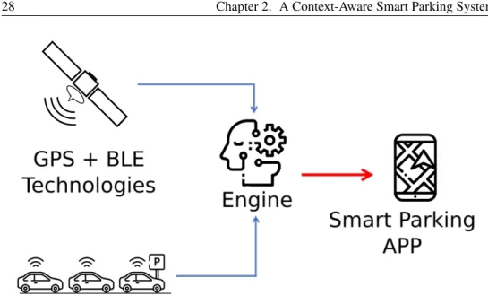
The architecture of the proposed Smart Parking system is shown in Fig. 2.1. As aforementioned in the introduction, this system takes advantage of some of the technologies integrated in recent smartphones such as GPS and Blue-tooth Low Energy (BLE) to gather information about position and adjacent passengers. User position, path performed by user, user activity (driving, walking, etc.), and list of potential close passengers represent the main data inputs for the Engine entity which makes use of an algorithm to retrieve the details related to a parking scenario. An important task of the Engine is to collect information related to passengers of a vehicle, establishing how many and who are them, and evaluating the similarity among paths. This evaluation tries to determine whether more drivers have performed the same route with different vehicles, and then, if one or more parking slots have been occupied. The Engine holds a database that contains a GeoJSON description [50] of a set of parking areas, useful to track in real-time available slots. When a driver reaches a parking area and parks in an available slot, the Engine decreases in its database the number of available slots for this geographic area. Users can receive notifications or read the information sent by the Engine to their smartphones through the Smart Parking application developed for this pur-pose. The application shows available parking areas close to user’s position or his points of interest, making the application context-aware as depicted in Fig. 2.2.
Figure 2.1: Proposed system architecture: sensing (GPS+BLE) and presen-tation (Smart Parking App) layers reside in smartphones while the Engine component is hosted in an external server.
2.1.1
Smartphone and Driver
The system described in Fig. 2.1 exploits the use of user’s smartphone with-out additional sensors or a complex external infrastructure. Google provides a set of APIs to retrieve user’s position and detect his activity in order to dis-criminate between a “driving” or “walking” state.
Determining whether a user arrives in a park zone is very important: this check can be carried out through the aforementioned APIs. The condition “user is in a parking area” along with the change of state from “driving” to “walking” represent the discriminant which allows the Engine to detect a “parking” action.
This case identifies the occupation of a parking slot. Similarly, an area has a new free parking slot when the change from the state “walking” to the state “driving” is detected.
The smartphone, in which our prototypical application is installed, period-ically sends information while the user is driving. This frame contains some details, such as the GPS coordinates and a timestamp, as listed in Listing 2.1: Listing 2.1: JSON information fragment containing user’s activity details.
1 { 2 "latitude": 37.526084, 3 "longitude": 15.074081, 4 "activity": "DRIVING", 5 "timestamp": "2016−07−16T19:20:30+02:00", 6 }
Data are saved into a database and used by the Engine to build a path. It also collects several paths (one for each monitored user) to verify whether they are related to users traveling together. When a user is driving, his smartphone also tries discovering neighbors to identify them as passengers of the same vehicle. In its first version, the Smart Parking application asks the user to confirm the presence of other passengers (as shown in Fig. 2.2). Possible passengers are discovered exploiting the BLE advertising mode. In facts, when a user reach the state “Driving”, the smartphone will start advertising an identifier which has been assigned during the registration phase to each user. The smartphone stop advertising this identifier when the activity status comes back to “Walking”. To discover just the passengers inside the same vehicle the lowest transmission power for BLE is set. This and some other data are used by the Engine to classify the users of the application discriminating possible drivers from passengers.
identifiers, in facts, as aforementioned, a user can select passengers traveling with him. These identifiers will be merged in a new single entity which rep-resents a group of users. When the group will change its state from “Driving” to “Walking” the Engine will decrease the number of free available slots of one unit. If no information about passengers is provided, the Engine will take into account just the paths built during the different journeys. These paths are used by an algorithm to estimate the number of parking slots occupied. This process is needed to evaluate if two or more users filled two different slot (with two different vehicles) or if they used the same slot (one vehicles and two or more passengers). In this way, some paths could be similar each other because they are built from the same vehicle (users have used the same vehicle to reach the same destination), partially similar because users shared a part of path, or different because each user drove different vehicles.
2.1.3
Application (Presentation Layer)
The most important goals of the Smart Parking application are the presenta-tion of results originating by the engine and the acquisipresenta-tion of the data (loca-tion and other contextual informa(loca-tion) and the sending of these to the Engine. The presentation layer shows parking areas near the user’s position or inter-esting and visited locations. For each parking area an evaluation of vacant slots is displayed in the form of a heatmap as depicted in Fig. 2.2. The color of the area represents the probability of find a free slot parking. The green color indicates that there are a large probability to find a free parking. The red color highlights a very busy parking area. The yellow and orange represent the middle way between a full and a free parking area.
2.1.4
Algorithm to determine occupied parking slots
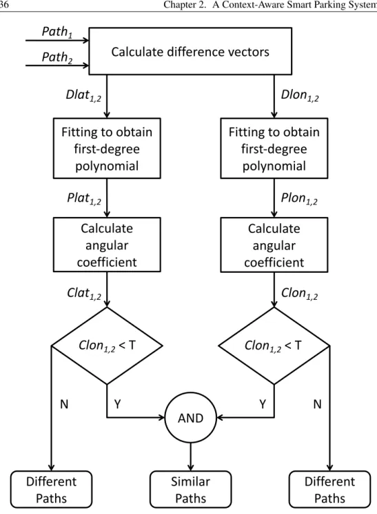
In the case passengers related information is not provided by the application users, the Engine tries comparing paths through the algorithm described in the followings.
The algorithm in Fig. 2.3 takes into account two paths called Path1 and
Path2 and indicates, as output, whether they are similar. It compares paths
under several constraints, in particular, the paths must share:
• the same arrival point (in terms of coordinates, inside a limited range); • the destination must be reached by users at the same time. So, the arrival
times must be “reasonably” similar;
• the information submission rate to the Engine is assumed to be constant. Each path consists of a series of coordinates, latitude and longitude, with PathN the generic path in which:
PathZ = x1,y1,x2,y2,x3,y3, ...,xn,yn
xn is the nth latitude value of the path and ynis the nth longitude value of the
PathZ.
Starting from a generic PathZ two arrays are built. The first array, namely
LatZ, is composed of latitudes of a path, while the second array, LonZ, consist
of longitudes coordinates of the same path.
LatZ = x1,x2,x3, ...,xn LonZ= y1,y2,y3, ...,yn
At this point, from Path1 and Path2 we build two other arrays, called,
DLat1,2= Lat1−Lat2 DLon1,2= Lon1−Lon2
These latter arrays DLat1,2 and DLon1,2 let us build two polynomials,
namely, PLat1,2and PLon1,2through a linear fitting function.
Each polynomial represents a straight line with an angular coefficient C. yx = Cx
The goal of the algorithm is to find a correlation between the angular coeffi-cient C and the similitude between Path1and Path2. Starting from the
com-parison between the angular coefficient of the straight line, calculated with the above formulas, and a threshold T , if the angular coefficient is less than the threshold, the algorithm consider the paths as similar. The best case is repre-sented from a straight line corresponding to the X axis of a Cartesian plane or having an angular coefficient near to zero. In this case, Path1 and Path2
would be similar and the subtraction vectors DLat1,2and DLon1,2would
con-tain only zeros. An angular coefficient very close to zero indicates an high degree of similitude. Several tests highlight that the angular coefficient of the straight line calculated starting from two similar paths is proximal to 10−4.
For this reason, we have chosen 10−4 as threshold to say that two paths are
similar.
Another measure of similarity between curves is the Fréchet distance which is defined as the length of the shortest leash between two curves that is sufficient for traversing both of them. The Fréchet distance can be used for evaluating similarity among several curves, but it does not determine an ab-solute value of similarity that is important to establish a threshold to evaluate the degree of similarity.
2.2
Experiments
A series of paths have been used to test the solution. For example, the paths shown in Fig 2.4 have been analyzed. The Path 1 in Fig. 2.4a and Path 2 in Fig. 2.4b are very different although they share the same arrival destina-tion. We analyze now our use cases. They consist on the comparison among different routes made by several users in the case no one of them indicates passengers with him. In particular, for the first user case we have supposed that three users U1, U2, and U3 have driven through a route corresponding to the Path shown in Fig. 2.4a. So, we would demonstrate that these users have traveled in the same vehicle. In the second use case, the users drove through different routes, corresponding respectively to the Fig. 2.4a (user U1) and Fig. 2.4b (user U4), so, these user were in different vehicles probably.
In the first case, we have calculated the vectors DLat1,2, DLat1,3, DLon1,2
and DLon1,3. The angular coefficients calculated through our algorithm are of
the order of 10−4. These results are interpreted by the algorithm as “Similar
Path” output. So, the path of user U1 are very similar to the path of user U2 and path of user U3. Probably, these user have reached their destination by the same vehicle.
The second case has the goal to analyze the angular coefficient obtained from two very different paths for users U1 and U4. In this case there is an angular coefficient major of 10−4.
2.3
Results
This chapter describes the architecture of a free park slot discovery system demonstrating that it is possible to implement such a system without so-phisticated and expensive infrastructures but taking advantage of currently
widespread technologies available in common smartphones. This system of-fers better results with a large number of users since the discovery process relies on information gathered from their smartphones.
Calculate difference vectors
Fitting to obtain
first-degree
polynomial
Fitting to obtain
first-degree
polynomial
Calculate
angular
coefficient
Calculate
angular
coefficient
AND
Different
Paths
Similar
Paths
Different
Paths
Path
1Path
2N
Y
Y
N
Dlat
1,2Dlon
1,2Plat
1,2Clat
1,2Plon
1,2Clon
1,2Clon
1,2< T
Clon
1,2< T
Figure 2.3: Algorithm adopted to evaluate the similarity between two different paths.
THREE
INTENT-BASED INTERACTION USING SMART
COOPERATIVE OBJECTS
Systems and solutions based on the Internet of Things (IoT) paradigm fre-quently rely on the use of smart objects, which represent an interface with the surrounding environment. The spread of smart objects in areas/spaces fre-quented during activities of daily life enables people to use a plethora of these services but, often, is not clear for users which services are available in a spe-cific place at a spespe-cific moment. To cope with this situation, in this work, a system to improve the discovery of smart objects (and related services), based on user-related contextual information is described. The proposal moves to-wards a transparent and easy interaction among users and smart objects and it does not require complex registration and setup phases.
As mentioned above,the IoT has entered into people’s lives by augmenting the capabilities of everyday objects in terms of computational power, connec-tivity, and intelligence [1–3]. In line with the IoT vision, a set of
ing/sensing elements can gather information from the context and act to su-pervise and manipulate the surrounding environment accordingly to the needs of users [5, 51].
An interesting class of scenarios related to the everyday life is that of Smart Spaces: environments equipped with pervasive devices, sensors, and actuators that can perceive and react to people, sensing ongoing human activ-ities and responding to them [52]. Smart Spaces range from single rooms, to cities, going through buildings and small areas such as campuses, and they, each one at a different scale, tend to present similar challenges. The widespread use of technological solutions leads to an increasing attention to-wards devices which are able to interact with domestic environments, offices or any place in which people spend their time. Nonetheless, these devices are at the first step of an evolutionary process and their smartness is evolving in the direction of a social consciousness [40]: smart objects communicate with others (friends) generating networks of objects and services.
The fact that more and more common objects are becoming capable of accessing the Internet, has generated interest on the development of hubs and management systems that collect and make accessible features offered by smart objects [53, 54]. For example, several frameworks allow the de-tection of smart objects in order to exploit services of interest using popular devices like smartphones. Various centralised architectures, presented in 3.1, have been proposed to achieve objectives defined by users or by their pref-erences and usually these solutions require a complex registration phase for each smart object to make it discoverable.
In contrast with a centralised approach, we prefer a solution based on the concept of Smart Cooperative Objects. The idea behind the proposed work is to create a way to gain control of devices, located into a Smart Environ-ment, identified as “neighbours” in terms of spatial location with respect to
the user’s location and capable of performing or scheduling useful tasks. In particular, this work aims to introduce a system to enable users, through their handheld devices, in the processes of discovery and exploitation of indoor-localised smart objects using peer-to-peer (P2P) communication.
3.1
Related Work in literature
With smart objects, the Internet connectivity has entered into a wide range of devices enabling the arise of a plethora of solutions in a variety of domains such as those connected to the IoT paradigm [5]. Examples related to the sce-nario of smart environments, taken into account in this work, come from smart cities, smart offices, and smart homes. One of the main challenges, still open in all these domains, is represented by the discovery of smart objects and/or services. This process has been tackled by middlewares [55] and frameworks designed to handle IoT objects as localised services [56]. In [57] authors present the IoT Service Discovery Framework, a solution that tries simplify-ing the detection of IoT services by introducsimplify-ing users’ preferences, specified through a smartphone application, to exploit services of interest. Currently an unified way to discover services in a smart city does not exist and this ap-proach turns out to be useful for the detection of unknown services localised within a specific environment, while users’ preferences represent the keys to discover nearby services that are not longer meant to be installed as single ap-plications in smartphones or laptops, but are exposed in a specific Store. This framework supports various methods to discover devices, including beacons, which are small BLE radio transmitters that allow to broadcast an identifier related to a specific device, providing a point of access to gather information about it. The discovery of neighbour smart objects is an important issue within