Dipartimento di Ingegneria Civile
Dottorato di Ricerca
in
Rischio e sostenibilità nei sistemi dell'ingegneria civile, edile ed
ambientale
XXXI Ciclo (2015-2018)
Anno 2017/2018
Tesi di dottorato in:
Innovative probabilistic methodologies to assess
seismic vulnerability of simple supported girder
bridges
Angelo Mammone
Il Coordinatore
Prof. Fernando Farternali
I Tutor
Prof. Luigi Petti
Prof. Vincenzo Piluso
Il
Dottorando
Acknowledgment
At the end of this PhD project, I feel the duty and the pleasure of thanking
everybody that supported me. I want to express my most sincere gratefulness
to the Prof. Ing. Luigi Petti who gave me the opportunity to undertake this
course of research, in particular on multiple issues of structural engineering,
and he was a guide and a point of reference for me. I also thank Prof. Ing.
Vincenzo Piluso for his scientific support.
A special thanks to Doctor Francesco Sicignano for his assistance and
essential suggestions, Ing. Antonio Ansalone for his welcome opinion and his
support, Ing. Domenico Greco and Dott. Carmine Di Muro which gave me a
support a in performing my tasks.
I would also like to thank the Department of Steel and Composite Structures
of the University of Kassel and all the staff, for the valuable support of
research activities for the thesis during my study period abroad.
Index
1.
Introduction
7
1.1 Seismic vulnerability and the damages
8
1.2 The social economic contest
10
1.3 The lifelines system
11
1.4 Road infrastructures of the transport system
14
1.5 Objectives and scope of research
15
2.
Damage of bridges during recent earthquakes
17
2.1 Recent earthquakes
17
2.1.1 Loma Prieta earthquake
17
2.1.2 Northridge earthquake
19
2.1.3 Kobe earthquake
21
2.1.4 L’Aquila earthquake
24
2.1.5 Haiti earthquake
25
2.1.6 Christchurch earthquake and Tōhoku earthquake
26
2.1.7 Emilia Romagna earthquake
28
2.1.8 Central Italy earthquake
30
2.2 State of the art of the Italian road
31
2.2.1 Recurring damage to Italian bridges
33
3.
Seismic Probabilistic Risk Analysis: Performance-based Earthquake
Engineering (PBEE)
35
3.1 Hazard Analysis
37
3.2 Structural Analysis
39
3.3 Damage and Loss Analyses
41
4.
Fragility curves: Methodologies and procedures
45
4.1 Introduction
45
4.2 Overview of key concepts
46
4.2.1 Uncertainty and risk
46
4.2.2 Design factor of safety
47
4.2.3 Reliability index
48
4.2.4 Fragility curve
51
4.3 Seismic fragility analysis focused on the bridge
55
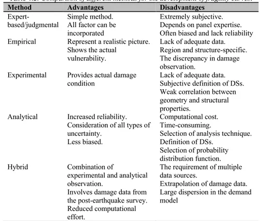
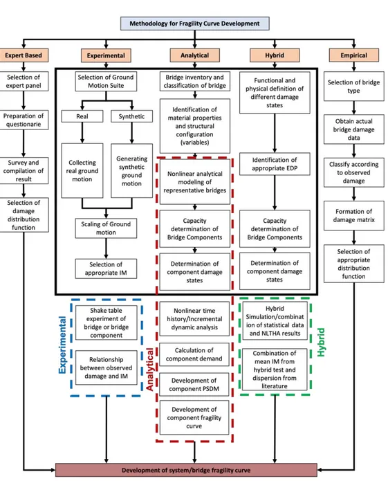
4.4 Methods to develop Fragility Curves
57
4.4.1 Expert-based/Judgmental approaches
58
4.4.2 Empirical approaches
60
4.4.3 Experimental fragility curves
61
4.4.4 Analytical approaches
62
4.4.5 Hybrid approaches
67
4.5 Intensity Measure for Fragility Analysis
68
4.6 Damage state for Fragility Analysis
70
4.7 Estimating fragility function parameters
72
4.7.1 Fragility by the method of moments
73
4.7.2 Fragility by least squares regression
73
4.7.3 Estimates fragility by maximum likelihood
74
4.7.4 Fragility by truncated IDA method
75
4.7.5 Fragility by multiple stripes analysis
76
4.8 Overview of the literature
77
5.
Specific design and retrofitting criteria for bridge
81
5.1 Criteria for bridge design in the international organisations
81
5.1.1 California USA (CALTRANS)
81
5.1.2 Oregon USA (ODOT)
82
5.1.3 Japan road association
82
5.1.4 Eurocode
84
5.2 Samples of retrofitting methods for R/C bridges
85
5.2.1 Introduction
85
5.2.2 Bridge decks and girders
86
5.2.3 Piers
89
5.2.4 Footings
90
6.
Case study
91
6.1 Selected bridge geometrical configuration
91
6.1.1 Deck 92
6.1.2 Bearings
93
6.1.3 Piers
93
6.2 Retrofit Strategies
94
6.3.1 Material Properties
96
6.3.2 Modelling of Deck
98
6.3.3 Modelling of Cap-beam
99
6.3.4 Modelling of bearing
99
6.3.5 Modelling of Piers
100
6.4 Modelling of the retrofit proposal
107
6.4.1 ROD
107
6.4.2 R=2,5 m and R=3,1 m
107
6.4.3 R ROD – Model
109
6.4.4 Modal Analysis
109
6.5 Analytical Fragility Curves
113
6.5.1 Description of bridge capacity
113
6.5.2 Assessment of the Limit States thresholds
114
6.5.3 Seismic Demand
115
6.5.4 Non-linear time history analysis
121
6.5.5 Component fragility curves
123
6.6 Combining fragility curves
150
6.6.1 Model SL
151
6.6.2 Model SLS
155
6.6.3 Model SSLLS
159
6.6.4 Model SSLLLLSS
163
7.
Conclusions
169
References
171
Appendix A
185
1. Introduction
Seismic events are natural disasters that affect populations and anthropic systems, often with catastrophic consequences. Scientific research, with several studies in the various branches (geophysics, geotechnics, engineering structures, etc.), has tried to mitigate the destruction and damages caused by earthquakes. In this context, for several years, methodologies have been introduced for the evaluation of seismic risk on buildings to define the expected damage following a seismic shock on a given urban reality and to identify all the elements at high risk. In these risk assessments, an essential component has often been neglected or at least left in the background: the transport system.
Figure 1.1: Damage distribution on the transportation line Northridge (left), Intersection Interstate 5 to State Route 14 damage (right)
USGS Response to an Urban Earthquake: Northridge '94.
The Californian earthquakes of Loma Prieta (1989) and Northridge (1994) (Figure 1.1) and the Japanese earthquake of Kobe (1995) have dramatically highlighted the importance of the transport network and the need for it to remain usable even after an earthquake. If this is the case, the rescue teams will have the possibility to quickly
and easily reach the affected areas, avoiding or limiting further hazards (such as fires) that could cause damage of magnitude comparable to those induced by the earthquake. Another aspect of fundamental importance in the global assessment of the seismic risk is the exposure of the user population to the transport networks, in addition to the "classical" one of the resident populations. Highways, roads, railways, stations, etc. they are widely used infrastructure where the number of people present is comparable to that found in buildings. In this regard, it is recalled that in the Californian earthquake of 1989 (Loma Prieta) the collapse of the viaducts that formed the elevated part of the busy Cypress Street caused most of the victims.
1.1 Seismic vulnerability and the damages
The seismic vulnerability is defined as the propensity of people, artefacts, activities or goods to suffer damage or modification caused by the earthquake (Dolce 1997). Considering a single element or to the whole system, vulnerability is a measure of the loss or the reduction of capacity to perform a normal function. Since the concept of seismic vulnerability is extremely complex and differently structured according to the object to which it is applied, it is useful to distinguish the following components: direct, induced and deferred.
The direct vulnerability is defined as the propensity of a single element, simple or complex, to be damaged or collapsed following a seismic shock. For example, one can talk about the direct vulnerability of a building or a viaduct. With the term vulnerability induced, it is referred, instead, to the effects of the crisis of the organisation of the territory caused by the collapse of one or more elements that constitute it (for example the crisis of the mobility system induced by the impracticability of a road). Deferred vulnerability refers to all the effects that occur in the subsequent phases of the earthquake, such as to modify, if not distort, the habits and behaviour of the settled populations. For example, consider the discomfort produced by the temporary use of emergency housing (tent cities, containers, schools, etc.) or the reduction of the employment base due to the collapse of industrial plants.
A very delicate passage on which it is undoubtedly appropriate to make some reflections is the extension of the concept of vulnerability from the single element to a group. In the past, an attempt was made to make the global vulnerability coincide with the sum of the vulnerabilities of the single constituent elements. It immediately becomes clear that such a definition is insufficient to describe the real conditions of the global vulnerability of the system. For example, consider an urban aggregate:
with a methodology of this type, some fundamental aspects would not be taken into account, such as the interrelations that occur between the buildings for the induced damage that some may cause to others.
In other cases, it may be essential to give a hierarchical classification of the elements: for example, think of a system organised with a tree structure. In this case it immediately becomes clear that the global vulnerability of the system cannot be expressed as a simple sum of the elements: a failure on one of the main branches would, in fact, put a good part of the network out, while a failure on a secondary or quasi-terminal branch would cause minimal damage.
Therefore, for a correct assessment of the global vulnerability, it is necessary to assign different "weights" to the individual elements, depending on the hierarchical role they play within the network. In general, it is possible to affirm that the global vulnerability of a system depends both on the direct vulnerability of the individual elements that are part of it, and on the interrelation between them and its structural organisation.
The concept of vulnerability so far discussed was intended as purely "physical", that is, "structural". However, it has been recently shown that the damage caused by an earthquake is vitally linked to the quality and quantity of the functions and activities that took place before the earthquake. By evaluating, in the long term, the effects of deferred seismic vulnerability, it is essential to keep in mind that, as a result of the earthquake, the conditions for carrying out the complex functions assigned to the various elements of the system or a part of the system of it could not subsist. The lack of functionality of some elements or the interruption of the performance of certain activities could cause significant damages to the territorial system affected by the earthquake: this is why the concept of functional vulnerability has been introduced alongside the already treated physical (or structural) vulnerability (ASCE 1995).
Many studies have also highlighted the extreme importance of some economic and social factors for the assessment of the global vulnerability of an area (ASCE 1990, ASCE 1991). Indeed, experience has shown that, beyond the purely "physical" damage suffered by a building due to an earthquake, economic, social and political conditions are those that more than others have had greater weight on resilience and reconstruction capabilities of the area. Damages, even if not very extensive, are difficult to heal in weak contexts from an economic and social point of view. On the
contrary, in the presence of flourishing economic conditions and stable social context, autonomous resilience capacities increase considerably. The concept of socio-economic vulnerability has been introduced to give an evaluation of these last aspects (ASCE 1992; ASCE 1996).
1.2 The social economic contest
The study of the anthropised territories represents a complicated and extremely complex operation to be managed for different reasons. The first difficulty to be faced derives very often from the considerable size of the area to be analysed, especially when compared to the level of detail required by some types of study. Secondly, considering the extreme variability and the vast number of anthropic activities distributed throughout the urbanized areas, starting an exhaustive analysis that does not neglect any aspect, appears almost an impossible task if not supported by an appropriate methodological approach.
What is briefly described above applies even more in a multidisciplinary procedure such as the seismic risk assessment. This assessment is based on territorial analysis that requires the acquisition of a large number of data, from different origins and of different nature, which will subsequently be assembled and processed according to appropriate and efficient criteria, to obtain realistic, reliable results and significance. It is, therefore, necessary to refer to a precise and rigorous application methodology, but that needs to be very flexible to be adapted to the different anthropic realities distributed on the studied territory. One of the most used methodologies for seismic risk assessment is the territorial analysis with a systemic approach. A group of objects is defined, indicating with an element each of the objects that compose it. A set able to pursue a goal or to perform a function through the interrelation between its components takes the name of system. It is, therefore, possible to imagine the territory as a complex system, that is composed of a series of related subsystems, each of which plays a particular role in the overall functioning of the system. The morphological configuration, the function performed, and the typology of the elements make it possible to subdivide the territorial subsystems into two broad categories: space systems and network systems. Spatial systems have a precise localisation within the territory and perform different functions: residential, productive, commercial, administrative, etc. According to the various possible scales of analysis, space systems can identify themselves, in a context territorial area, with an urban settlement or, in a less extensive area of study, with parts of it (for example, the commercial district or the industrial sector) until reaching the individual building
(for example a business centre) for extremely localized studies. The scale of study most commonly used to develop territorial applications for seismic risk assessment is regional or sub-regional. Network systems are sets of linear entities (branches) that converge and diverge from various points called nodes, constituting real networks on the territory. Each network has the function of guaranteeing a specific type of relationship between the multiple space systems: connections, distribution of goods and resources (energy, raw materials, information). It is crucial to bear in mind the distinction between these two types of territorial anthropic systems because it involves considerable differences regarding definitions, approach and application of any methodological procedure. For example, in a seismic risk assessment study, in the definition of exposure of the population reference should be made to the residing persons in the case of a spatial system with residential functionality, to the traffic flows present in the various hours of the day in the case of a network system aimed at road communications. Therefore, the same object (the population exposed to seismic risk) should be studied as a static entity in the case of a spatial system or as a dynamic entity in the case of a network system. For this reason, in the following paragraphs will be developed and deepened the issues related to the infrastructures with a typical type of network systems lifelines.
1.3 The lifelines system
Modern society is dependent on a sophisticated and complex network of infrastructures of vital importance for the existence of current human settlements distributed throughout the territory. These systems of infrastructures, called lifelines, are entrusted with numerous services and functions that are indispensable for regular use of the current urban realities as well as for the performance of any human activity. The lifelines, in essence, are network systems that appear on the territory, on the surface, in elevation or the subsoil. The lifelines connect the various space systems, guaranteeing them a multitude of essential and indispensable services for the survival of the current society: the transport, distribution of energy resources (gas, electricity), the functioning of the toilets and health (aqueducts, sewers), telecommunications, etc.
The lifelines represent the set of network systems (always composed of linear elements) that are used to guarantee all those services indispensable for the survival of the local anthropic settlements. Synthetically we can define lifelines the set of equipment, facilities and services that are part of all those human infrastructures essential to ensure the vital functions of these systems. The lifelines can be divided into the different areas of interest listed below:
• transport; • electric energy; • gas and liquid fuels;
• aqueducts and drainage system; • telecommunications.
Each of these systems has its own functional and technical construction characteristics, so it may seem risky to bring them together under the same definition. However, they have a common feature: they are all networked systems that provide vital functionality for any settlement. In anticipation or case of an emergency, therefore, even if from a technical-operational point of view it is difficult and often impossible to implement common interventions or constructive devices that reduce the vulnerability, from a regional planning point of view the approach and the treatment criteria for these systems are similar.
For these reasons today we speak, in research environments, of real seismic engineering of lifelines (Lifeline Earthquake Engineering). This term indicates all the knowledge and methodologies to design these systems according to a plan that minimises exposure and to build following technologies that, for each type of infrastructure, reduce vulnerability. It is important to underline that lifeline engineering must not only refer to seismic events but, in general, to any type of emergency arising from a generic natural or anthropic disaster: meteorological or hydrogeological catastrophes, floods, fires, etc. Therefore, designing according to these criteria the lifeline systems means having greater guarantees of reliability and efficiency in an emergency condition. These aspects of the design and management of infrastructures, long neglected in the past, have been taken into consideration and deepened only for some years now. Recent experiences have shown the extreme importance of the proper functioning of the lifelines in the emergency conditions that follow any catastrophic event.
Some lifelines must be able to function immediately after an earthquake (sometimes even during) to allow rapid and effective implementation of the assistance and rescue procedures and support all emergency services. An interruption in the transport network, for example, makes access to the affected areas impossible to rescue vehicles: this aspect, which may seem negligible, assumes a decisive weight in reality. The speed and promptness in providing operations valid and useful help have proved to be an essential element for the health (or even survival) of the affected populations. On the other hand, any rescue operation needs, to be practical, an organisation based on the coordination of several bodies, each with its skills and
human and economic resources. It is evident that the collapse of telecommunications lifelines would negatively affect the organisation of relief efforts, causing difficulties and slowness in managing contacts and, consequently, poor exploitation of (usually) scarce resources available. Likewise, the non-functioning of the electricity or water distribution networks would make useless or at least poorly efficient many elements considered "strategic" for public health, especially in emergency conditions: hospitals, civil protection structures, military barracks and fire brigades, etc. It is also essential that the whole set of lifelines, possibly damaged, can be repaired rather quickly to provide for the improvement of the movements and services required for the sustenance of the population and to start the post-earthquake reconstruction process as soon as possible. What has been said so far highlights the importance and usefulness of taking advantage of efficient lifelines in the phases immediately following the seismic event.
However, it should not be forgotten that the proper design of the lifelines can also be advantageous to prevent many of the damaging effects of the earthquake. Consider, for example, fires caused by the breaking of urban gas pipes or broken electricity lines. In a zone whose accessibility has been compromised as a result of the shock, the fire can have catastrophic effects comparable to those of the earthquake itself. The Japanese city of Kobe, for example, hit in 1995 by a violent earthquake, was devastated by both the fires caused by the earthquake and the earthquake itself. Damage due to fire was aggravated by the interruption of the access routes that made the rescue operations difficult for many hours. The systems of the lifelines, therefore, represent, as already mentioned, an essential element that must undoubtedly be taken into consideration in all the anthropised areas that present a specific seismic hazard. It is important that, in these areas, they are designed according to appropriate criteria that always refer to two fundamental rules: the determination of the best territorial location, avoiding, as far as possible, the places with the highest danger; the application of construction technologies aimed at the vulnerability reduction.
Therefore, it is essential that in any modern seismic risk assessment process the study of lifeline networks, to be integrated with the more traditional building analysis, is taken into due consideration. The present work will be dedicated to a type of lifeline: the transport network for road infrastructures.
1.4 Road infrastructures of the transport system
Most of the transport system consists of infrastructures that are fully included in the lifeline category. Suffice it to think of the road and rail networks that serve the territory and urban settlements, or to the typical urban mobility systems such as subways or tramways: they are all network systems that connect different locations in order to meet transport needs — both passengers and goods. It is therefore entirely correct, according to the definitions given, to include these types of transport infrastructures within the lifelines.
The main characteristic that distinguishes transport infrastructures from all other types of lifelines is the direct use by humans to meet their mobility needs. All the other lifeline systems, even though close to humans, are never directly used by them. Although most of these systems, due to the transported elements (for example gas), indirectly exposes man to considerable risk in case of the seismic event, with consequences often severe (fires, etc..) it is always however indirect risks that fall on the population.
In the case of transport systems, there is direct exposure to the seismic risk of the users. Therefore, if a road infrastructure were exposed to seismic risk, with it would be exposed directly all the users. This singular characteristic, which is not found in any other type of lifeline, is significant for a complete evaluation of the seismic risk of an area because the principal object of the exposure analysis is constituted by the population that could be directly affected following a seismic event. For reasons of simplicity of design and economic convenience of construction and management, it is now customary that many wiring or pipe installation systems take place within the road body. The methane pipelines, water pipes, electric cables and telecommunications are often passed through road sections with the following advantages: it is possible to use an existing territorial tracing. The installation is generally very simplified as it takes place in parts of the road section specially designed and leased to various entities by the road management company. Moreover, during installation, management and maintenance will always be guaranteed great accessibility to each part of the network.
However, these numerous advantages come with numerous problems linked to the risk of natural disasters such as an earthquake. With such an integration of the lifelines, it becomes indeed complicated, if not impossible, to evaluate the effects of an earthquake only on one lifeline, neglecting the others. The interactions between the various networks are so tight that it is possible to evaluate just a global effect
(presumably of considerable entity) as a consequence of the mutually induced effects between the various systems. If the seismic shocks damaged a road infrastructure built in this way, the effects induced by the possible damage of the integrated lifelines could have repercussions on the road itself, regardless of the damage directly suffered. These induced phenomena would further exacerbate the damage to the road.
The reasons for which transport infrastructures play a decisive role, in an area hit by an earthquake, both in the phases immediately following the earthquake and at longer expiry will be highlighted. For the same reasons it is essential that, in any seismic risk assessment procedure in an area, the transport system is taken into great consideration, which must be examined in all its components according to exposure and vulnerability.
1.5 Objectives and scope of research
Bridges undoubtedly represent the components that most strongly affect the risk of a network system such as road infrastructure. Many are the elements that determine this vulnerability and among these the morphology and the structural characteristics of the same play a fundamental role. Furthermore, the configuration of bridges involves general structures throughout the territory and, therefore, too high risks for different hazards. The damage or collapse of a network bridge can determine, the loss of functionality of the entire branch to which it belongs would inevitably lack the link between two nodes.
The loss of functionality of the bridges is at the centre of the studies of many international organisations in the field of transport such as CALTRANS, AASTHO, FHWA, JRPA, EUROCODE; these associations have long paid attention to aspects related to the fragility of these structures. In the design phase of bridges in seismic zones, the concept of expected performance or performance has been introduced over the last decades. A new design philosophy called Performance-Based Seismic Design was introduced.
The primary objective of the work is the study of an innovative method for the evaluation of the seismic vulnerability of existing reinforced concrete bridges in a probabilistic way, by using fragility curves. Fragility curves, as can be seen in the scientific literature, have highlighted the complexity of the bridge system, making it difficult to use in daily practice. This difficulty depends on being able to consider the bridge in its entirety, the use of a new combination between the engineering
parameters would give the possibility both to understand the behaviour of the single structural element that of the entire bridge.
In particular, the research study wants to investigate the problems of simple supported girder bridges through the study of a sample bridge defined by geometrical and mechanical characteristics typical of Italian bridges of the 60s.
The methodology for assessing the seismic vulnerability, in a probabilistic way, of existing bridges and viaducts, consists in the construction of the so-called "fragility curves", i.e. the relationships that represent the probability of exceeding a predefined level of damage for a given value of seismic intensity (Padgett 2007). The degree of safety has been evaluated in a probabilistic way, that is through the calculation of the probability of failure of the individual bridges, whose capacity has a duly characterised uncertainty when faced with a specific seismic scenario, also defined statistically. Various analytical procedures have therefore been developed to determine a correlation between the possible seismic event and its likely consequences concerning damage status (Padgett 2007). The study of each of the aspects mentioned was systematically done using parametric studies, in which the results were subjected to statistical treatment, to allow the coverage of a large number of different structural configurations and earthquakes and to achieve generalised results.
A portfolio of bridges, together with a relatively large number of seismic events, has been used for this research. These analyses make it possible to define the seismic efficiency of the bridges, thus allowing to suppose what level of damage should be expected for a given seismic event and which are the most subject to damage with equal seismic intensity.
The levels of damage depend directly on the choice of the Engineering Demand Parameters (EDP). This choice often influences the results especially for complex structures such as the bridges, to make the fragility curves immediately readable, it is herein proposed an innovative combined use of the EDPs to understand both the behaviour of the single bridge elements and global behaviour. All this has the purpose of defining and planning which are the structural interventions of pre-earthquake adjustment to be done and how these improve the resistance capacity of the manufactured articles. This information is significant for the managing bodies of infrastructural networks that nowadays have more to deal with than the construction of new road networks, but with the management and maintenance of the built heritage.
2. Damage of bridges during recent earthquakes
2.1 Recent earthquakes
The strong earthquakes that affected both the most developed and the least developed countries have consequences that have always been significant and, sometimes, devastating for the populations. In the last fifty years, the exponential increase in the number of bridges and viaducts has made visible the effect of earthquakes on these structures, attracting the attention of the international scientific community. Bridges are complex structures composed of different structural elements that work together. Sometimes during the earthquakes, their behaviour is unpredictable, making their study significant to improve our understanding of these structures further.
In fact, in the last years, many studies have described the seismic behaviour of bridges describing the most relevant seismic events of the twentieth century, recalling the relevance of the study of seismic actions. In the twentieth century, there were hundreds of high magnitude earthquakes all over the world. However, for structural engineering, those that have occurred in regions with a high density of buildings, are more interesting, as they have involved a greater quantity of construction, bridges and viaducts designed with more advanced anti-seismic criteria. The analysis of the damages caused by the most representative earthquakes is very important for their contribution at the development of the anti-seismic design criteria. The goal of this chapter is to explain the damages caused by the earthquakes, for the bridge structures, of the most critical seismic events, occurred in the last years.
2.1.1 Loma Prieta earthquake
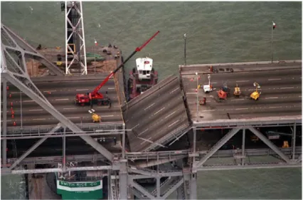
The earthquake of Loma Prieta, which shook the San Francisco Bay area in California in 1989, is a classic example of a natural disaster that has mostly affected a high population density area with an extensive network of motorway transport. Causing a total of 63 victims and nearly 4,000 injured, one particular aspect of this earthquake was that 42 of the victims were due to the collapse of the two levels of the Cypress Street viaduct of Interstate 880 in West Oakland, (Figure 2.1).
Nevertheless, less than 5% of the bridges exposed to ground shaking have been damaged.
Figure 2.1: Cypress viaduct collapse left – aerial view; right – piers failure detailed view. (Nakata et al. 1999)
The main factors that led to the collapse of the viaduct built in the late 50s, in addition to resonance effects, are geotechnical problems and deficiencies in the design of reinforced concrete structures. Two-column bents connected the upper and lower levels composing the structure in a combination of cast concrete and four pins (shear key) connections. The upper part in some sections was not firmly connected to the lower floor and, while the bridge vibrated during the earthquake, even the nodes that linked the levels began to vibrate, that led to the failing of the concrete that surrounded the nodes. There is no transversal reinforcement for the nodes between the piers and the deck.
Figure 2.2: Cypress viaduct: lack of proper reinforcement in pier-deck connections. (Nakata et al. 1999)
The connections of structural elements are often subject to a higher demand than the single parts, but in this case, ductile connections have not been used in the design or retrofitting phase. As for the geotechnical part, the viaduct was built on soft mud, weak soil, that is susceptible to liquefaction during an earthquake with large ground motion. Without the presence of the foundation under the piers, those elements slid sideways under the weight of the upper deck that led to the collapse of a large portion of the upper deck (Yashinsky, 1998a).
Therefore, some aspects of the design and construction of the structure contributed to the bridge collapse: inadequate transverse reinforcement in the columns, ineffective bent cap and pin connection design (Moehle, 1999) and inadequate compensation for weak soil conditions (Yashinsky, 1998a).
Figure 2.3: Oakland Bay Bridge: a collapsed portion of the upper deck. (Nakata et al. 1999).
The Oakland Bay Bridge has reported minor damages (Figure 2.3) a span of the upper road has collapsed on the lower deck, indirectly causing the death of some people. The satisfactory behaviour of this bridge can be attributed to the steel structure, a material with greater ductility than concrete, less vulnerable to seismic events. The need to pay attention to reinforced concrete bridges is therefore clear.
2.1.2 Northridge earthquake
The Northridge earthquake, named after a district in the city of Los Angeles, California, occurred in 1994, for about 45 seconds. With one of the highest ground accelerations measured in urban North America, around the 1.0g range, it has become one of the most expensive natural disasters in US history, causing 70 deaths
and over 9,000 injuries. After the 1989 Loma Prieta earthquake, a modernisation program began on Californian bridges and was yet to end when the Northridge earthquake took place. In the epicentre area, there were about 2000 bridges, ten of which were damaged, with four of them that had to be demolished and rebuilt. The damage reported following the earthquake involved a large part of the vast motorway network, with particular attention to the Santa Monica Freeway, which is used daily by millions of commuters, and the Antelope Valley Freeway, (Figure 2.4)
Figure 2.4: Collapsed section in Santa Monica (left) and Antelope Valley Freeway (right). (Todd et al. 1994)
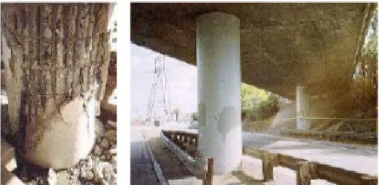
The collapse of the bridges was mainly due to the failure of the piers, designed and built before 1971, a critical moment, given that after the San Fernando earthquake the anti-seismic standards began to be considerably strengthened. The lack of adequate confinement of the reinforced concrete, with the consequent "bird cadging" effect of the steel reinforcement, or poor behaviour of flared pier tops are some typical examples of column failure, (Figure 2.5).
Figure 2.5: Failure of columns: insufficient confinement (left); shear failure (right). (Todd et al. 1994)
On the one hand, the retrofitted bridge did not report severe damage, according to (Yashinsky, 1998b) studies, only minor cracks to the slope paving. On the other hand, the damages on not retrofitted bridges, built in the same site, turned out to be high, (Figure 2.6) (Cooper et al., 1994).
Figure 2.6: Failure of the column due to the failure of circular confinement steel (left); good behaviour of column retrofitted (right). (Todd et al. 1994)
Other damages to bridges include spalling and cracking of concrete abutments, spalling of the concrete covering the columns, overturning or displacement of the steel and neoprene bearings. From these observations, it can be said that bridges designed and built before 1971 proved to be worse than those designed according to the latest standards, with the piers being the most damaged components (Basoz and Kiremidjian, 1998). However, the damage caused by the earthquake revealed that some structural specifications did not work as well as expected, as in the case of two bridges, both built shortly after the 1971 earthquake, on the Simi Valley-San Fernando Valley expressway. These bridges presented severe problems to the columns that caused the bridge to fail.
2.1.3 Kobe earthquake
The great earthquake of Hanshin occurred in January 1995 is often referred to as the Kobe earthquake because that was the most damaged city. The earthquake caused more than six thousand casualties, with 4600 from the city of Kobe. As it is easy to imagine, this was the worst earthquake in Japan since 1923. The comparison with the Northridge earthquake, which occurred only a year earlier, was inevitable. The city of Kobe was less fortunate since the damages caused by the earthquake was
much bigger than of those caused by the American earthquake. This difference mainly derives from the particular soil type in Kobe, as well as the not reinforced lightweight structures in masonry and wood. The damages observed at the bridges of the motorway network is the most familiar images of this seismic event:
- substructure failure, originating from simple shear failure in reinforced concrete columns;
- premature shear failure at terminations of longitudinal bars with insufficient development lengths;
- extensive failure of steel columns, the first in the world;
- soil liquefaction, leading to settlements and tilting of foundations and substructures and lateral spreading of ground associated.
One of the most important structural disasters was the collapse of the eighteen spans of the Fukae viaduct, serving Route 3, inside the elevated Hanshin Expressway, (Figure 2.7).
Figure 2.7: Collapsed Fukae Viaduct (left) and Premature Shear Failure of Reinforced Concrete Column, Fukae Viaduct (right) (Kawashima, 2007).
The viaduct was designed by using the 1964 Design Specification and was completed in 1969. Insufficient code provisions have led to significant problems in the design of the viaduct: the overestimated allowable shear effort, the insufficient development length of the longitudinal bars terminated at half height and the inadequate amount of tie bars. The combination of these aspects has led to the already mentioned failure of premature rupture.
In Figure 2.8, by Kawashima (Kawashima, 2007), is shown the possible mechanism of collapse of the viaduct that highlights the importance of the correct reinforcement of the piers, especially at the base, since the P-D effects were not considered.
The soil failure was equally frequent as many of the bridges had been built on sand-gravel terraces (alluvial deposits) that covered deposits of sand-gravel and sand at depths
of less than ten meters, a condition that is believed to have led to the amplification of the site of the rocky substrate motions.
Figure 2.8: Collapse mechanism of Fukae Viaduct (Kawashima, 2007).
There were also several situations of liquefaction and lateral spreading, with consequent permanent deformations of the substructure and loss of superstructure support (Moehle and Eberhard, 1999). The collapse of the span of the Nishinomiya-ko bridge approach, (Figure 2.9), is an excellent case of how the site conditions have significantly increased vulnerability.
Figure 2.9: Nishinomiya-ko Bridge approach span collapse (Kobe Collection, EERC Library, University of California, Berkeley).
The further collapse of bridges is a result of the damage of the device to prevent the unseating of the span, over the forces transmitted through unseating prevention devices.
2.1.4 L’Aquila earthquake
The L'Aquila earthquake, in April 2009, happened in the Abruzzo region, in central of the Italy, with a magnitude of 6.3 on the Richter scale. The epicentre was near L'Aquila, the capital of Abruzzo, which suffered the most significant damages together with the closer villages. The earthquake was felt throughout central Italy, with 308 casualties, making it one of the deadliest earthquakes that have hit Italy since 1980. Even though it has occurred in a well-developed country, with relatively advanced seismic regulation, the resulting damages were significant. This was mainly due to the high number of medieval, historic buildings and buildings with unreinforced walls, known to be very susceptible to seismic action. But not only the ancient structures in L’Aquila have suffered damage.
Many modern buildings considered resistant to the earthquake were damaged, such as a local university dormitory and the new wing of L’Aquila Hospital. The former was constructed with nonductile concrete, an irregular planar layout that led to soft story collapse. The latter, opened in 2000 and was designed to withstand a strong earthquake in safety, suffered considerable damage and had to be closed. This thing was surprising, given that the event was moderate and within the code provisions. The failure was admitted mainly due to the lack of a consistent seismic design (Miyamoto et al., 2009). However, the structures of the transport network, in particular bridges, have behaved well, suffering few damages. Usually, more damages are expected to this type of structures for an earthquake of greater magnitude or a longer duration of strong ground shaking. The worst case was a short 35-meter-long, three-span reinforced concrete bridge, not far from the epicentre, which collapsed on the riverbed, (Figure 2.10).
The four piers of reinforced concrete with hexagonal sections were broken at the connections of the base of the pier, sliding sideways and penetrating in the bridge deck. A masonry arch bridge, which had previously collapsed and was repaired with limestone, collapsed again during the earthquake, due to the probable movement of the abutments, with the consequent loss of the arched effect. Finally, some of the viaducts inside the A24 motorway near L'Aquila have been hit by the earthquake, even though the same highway has not collapsed anywhere (Aydan et al., 2009). Once again, the critical point is that, given the moderate nature of the earthquake, seismically designed bridges should not have collapsed, which indicates the need for a code review and a careful assessment of the safety of existing structures.
2.1.5 Haiti earthquake
The earthquake in Haiti, one of the most recent earthquakes and probably one of the most catastrophic, occurred in February 2010, causing the death of over 230,000 people. The consequences have been devastating mainly due to the general lack of attention to seismic design principles and construction practices that have led to the poor quality of the majority of the existing construction. The historical model of the earthquakes in Haiti indicates that one seismic event could damage southern Haiti near Port-au-Prince at any time. According to reports following the earthquake, no type of damaged bridges was recognised due to the earthquake. Within Port-au-Prince, the most affected city, most of the river crossing bridges did not collapse, (Figure 2.11). In any case, these river crossings can be dangerous in the future, since a large amount of dirt accumulated upstream that can, combined with silt and debris, prevent water from passing through the underground canals (Eberhard et al., 2010).
Figure 2.11: Box culvert in Port-au-Prince (
left
); damage to the shear key at intermediate support of bridge (right
) (Eberhard et al., 2010).Most of the crossings on the National River and 2, are bridges precast girders resting on cast-in-place reinforced concrete piers and supporting a cast-in-place deck. Damage was observed on two of these bridges. The Momance river bridge had minor pounding damage to the shear key on one of the intermediate supports that had probably not been adequately and accurately reinforced. A similar bridge in the Carrefour section of Port-au-Prince suffered damage on the outside of the shear keys on both intermediate supports, apparently caused by the lack of anchorage of the hook at the end of the reinforcement of the upper beam.
The simple damage analysis of Haiti earthquake allowed to conclude that the ground motion was not significant enough to severely damage well-designed structures. The absence of seismographic stations that worked during the main earthquake doesn’t allow for an accurate estimation of the intensity of the ground motions.
Several buildings and supporting structures survived the earthquake without severe damage. Similarly, bridges near the epicentre suffered only minor damages and could be immediately used after the seismic event. Unfortunately, this framework confirms the lack of attention to seismic design that persist throughout the world, with a significant incidence in developing countries.
2.1.6 Christchurch earthquake and Tōhoku earthquake
Both events described here, not only because they occurred in the same year but also because they both have happened in the so-called developed, prosperous, New Zealand and Japanese countries. The 2011 Christchurch earthquake was a 6.3 magnitude earthquake that struck the Canterbury region on the South Island of New Zealand on February 22, 2011, causing widespread damage and multiple deaths, although no collapse of bridges was reported. The earthquake of Canterbury of magnitude 7.3 in 2011, occurred almost six months later, causing significant damage to the region, but with no casualties. Analysts have estimated that the earthquake could cost insurers 12 billion dollars. Of the 3,000 buildings inspected in the city centre, around 45% could not be used for safety problems, and a thousand would have been demolished (about 25% of the total number of buildings). Many buildings of the cultural heritage have also received red stickers after the inspections but, in general, not many buildings have collapsed.
Examples include two six-story buildings: the Canterbury Television building and the PGC Building, (Figure 2.12), a reinforced concrete structure that was built in 1963-1964, which drew much attention to the high vulnerability of the buildings constructed before the ‘70. The seismic behaviour of these buildings includes the
failure of a column, column shear failure, beam-column joint failure, the onset of soft-storey failure, shear wall failure, etc. The 26-storey Grand Chancellor building, the tallest hotel in Christchurch, was on the verge of collapse and subsequently demolished in the following months. The most extensive damages occurred in older buildings, especially those with unreinforced masonry and those built before earthquake codes were introduced, the high rises constructed in the last twenty to thirty years have worked well (Kam, 2011).
Figure 2.12: The Pyne Gould Corporation (PGC) Building following the 2011 Christchurch earthquake (Kam 2011).
The Tōhoku earthquake on March 11, 2011, officially called the Great East Japan Earthquake, was a magnitude 9.0 earthquake. It is considered the most potent known earthquake in Japan, and one of the five most powerful earthquakes in the world since the beginning of the modern recording in 1900. The earthquake caused extremely destructive tsunami waves, causing numerous victims (around 14 616 deaths, 5278 injured and 11 111 missing persons), destruction of infrastructure and numerous nuclear accidents. The total cost exceeds $ 300 billion. Structurally, over 125,000 buildings have been damaged or destroyed, as well as roads, railways and bridges and a dam have collapsed.
Figure 2.13: Bridge collapse in 2011 Japan Earthquake and Tsunami. (TRDB 2011).
Apart from the obvious many structural failures, such as the failure of the bridge (Figure 2.13), the Japan earthquake of 2011 caused a severe nuclear accident, which has hit, over the present and future years, the natural resources of the planet. The devastating way in which the earthquake recently struck New Zealand and Japan is a sad but important reminder of how modern society is vulnerable to such events, even in relatively well-prepared countries.
2.1.7 Emilia Romagna earthquake
On 20 May 2012, an earthquake with a magnitude of ML = 5.9 hit the Emilia-Romagna Region and a small part of the Lombardy Region in the north of Italy. Subsequent earthquakes occurred on May 29, 2012 with ML = 5.8 and ML = 5.3. The earthquakes caused 27 deaths and 14,000 homeless people, including 13 on industrial buildings, 12,000 buildings were severely damaged. Also, serious damages have occurred to historical monuments, estimated at around 5-6 billion euros. In the reports of the post-earthquake observations, only minor damages to bridges and viaducts in RC are reported. The bridge in the outskirts of the city of Finale Emilia (Figure 2.14), the only visible damage is an insignificant cracking in an external section of the bridge at an expansion joint.
Instead, slight damage was observed in the masonry abutments of an old reinforced concrete arch bridge (Bomporto Bridge) built in 1914. No visible damage to the
reinforced concrete structure. However, the breakage of both masonry abutments (Figure 2.15), which in turn caused cracks in the road surface (Figure 2.15). This bridge had to be put on a regime of reduced traffic to lessen the load on the shoulders (Figure 2.15).
Figure 2.14: Precast concrete bridge outside Finale Emilia
2.1.8 Central Italy earthquake
On 24 August 2016, at 1.36 UTC, 3.36 local time, an earthquake with an epicentre located in the municipality of Accumoli, with a magnitude of MW 6.0, began the seismic sequence that affected Central Italy until 2017. The event of the 24 August was followed by countless aftershocks, the most important of which occurred on 26 October near Castelsantangelo sul Nera (MW 5.4 and MW 5.9), on 30 October near Norcia (MW 6.5) and on 18 January 2017 close to Capitignano, with four shocks with a magnitude of MW between 5.0 and 5.5. This seismic sequence caused considerable damage in a large area of central Italy, involving the four regions of Lazio, Umbria, Marche and Abruzzo, causing 298 deaths, 17,000 homeless.
Immediately after the seismic sequences of Central Italy, numerous inspections were done on several bridges with masonry structure, mixed masonry and RC and steel-concrete compounds. The RC bridges had a deck consisting of beams in RC prestressed. The beams are supported by elastomeric bearings, located above the piles, without the use of anchorage. It should be noted that these elastomeric bearings have been designed not as seismic isolation devices, but to resist vertical actions and to allow small displacements and relative rotations due to thermal variations. Moreover, due to the absence of anchorage or bolts, these devices allow the horizontal actions to be transferred between the deck and the transverse only as friction between the rubber and the concrete: for this reason, the deck tends to slide as soon as the lateral forces exceed the friction resistance. It is therefore evident that in this configuration the bridge deck is poorly constrained against horizontal displacements relative to the substructure (pier), although shear keys are sometimes made on the cross Girder and on the abutment, to prevent excessive lateral movements (Di Sarno et al. 2018).
Figure 2.16: Viaduct “Scandarello” SS4 Amatrice Italy. (ANAS, Relazione Esecutiva, 2010).
Despite the weak connection between the deck and the substructure, the elastomeric bearing appeared in good condition in all the inspected viaducts, with no signs of sliding concerning their original position, (Figure 2.17). Although no loss of support for beams supporting the deck was documented, slight damage due to excessive longitudinal displacements was found. These displacements caused hammering phenomena between successive spans or between end spans and abutment, causing cracks and concrete detachments on the cross girder and the abutment, (Figure 2.18). In the inspected viaducts no, significant damage to the piers was detected.
Figure 2.17: Elastomeric Bearing (Totaro photos).
Figure 2.18: Relative displacement of the Abutment
2.2 State of the art of the Italian road
The Italian road infrastructural heritage is composed of the national network, road (20773 km) and highway (6668 km), from the regional and provincial networks
(151583 km) and a countless of municipal road networks (72081 km). In particular, it consists of a large number of bridges, viaducts and overpasses necessary for the orography of the territory and the high urban density.
Figure 2.19: Evolution of the road infrastructures in Italy (ANAS). Table 2.1: Evolution of the road infrastructures in Italy (Office of Statistics 2014).
Years 1930 1990 2000 2012
Road [km] 20780 161938 167725 180175
Figure 2.19 Shows the exponential increase of Italian road infrastructures from 1928 to today; in 1928 the road network was 21,000 km long that has grown, according to data provided by ANAS and the Ministry of Infrastructure and Transport in the annual report (Office of Statistics 2014), to 180175 km by the end of 2012. 14% (Autostrade per l'Italia SpA 2015) (Figure 2.20) of this network are viaducts or bridge structures. (Casarotti, 2004) proposed an adequate structural classification of simple multi-span bridges built in the '70s and' 90s.
Figure 2.20: Report of Autostrade per l’Italia.
1%
14%
17%
68%
Report of Autostrade per l'Italia
Internation Tunnels Tunnels
Bridges Highway
From this study, it was possible to understand that in about 61% are used neoprene bearing devices and that most of the cases analysed have some span exceeding five (Figure 2.21).
Figure 2.21: Bearing device (left) and a number of spans of Italian Bridge (right).
2.2.1 Recurring damage to Italian bridges
Road infrastructures are very vulnerable, as they are affected by design (structural and technological) deficiencies related mainly to the construction period, to the applied technologies and the materials used, together, especially in the last few years, to a lack of adequate maintenance. Most of the bridges and viaducts in Italy were built between the 50s and 60s when the economic boom generated unlimited confidence in the use of concrete as a durable material for eternity. Moreover, most of these structures of the Italian road network were realised through the technology of the pre-stressed reinforced concrete, hardly compatible, with the concrete concepts of reliability. The inadequacy of the old design philosophies has been observed in the last decades, given the high vulnerability of these structures to the various seismic events that occurred in different parts of the world, even if the infrastructures had been designed with anti-seismic criteria (Priestley 1996). These structures are difficult to analyse for their very low ductility. This lack of ductility cannot be considered a design error. It would be more appropriate to underline that in the 60s two fundamental factors led to this situation:
- no awareness reinforced concrete could have such a short life and could suffer attacks and deterioration due to atmospheric agents and environmental;
- there were no automatic calculation tools, so, where possible, statically determined patterns were preferred, much more straightforward to calculate.
61,00 % 35,00
% 4,00%
Bearing device type
Neoprene Disc Friction 68,00 % 32,00 %
Number of Span
> 5 Spans < 5 SpansTherefore, it is, need to improve performance with the efficiency and level of simply supported multi-span bridges. The most frequent damage from the most recent earthquakes is that the common failure mechanisms are:
- Pier flexural failure; - Pier shear failure; - Unseating of the deck.
3. Seismic Probabilistic Risk Analysis:
Performance-based Earthquake Engineering (PBEE)
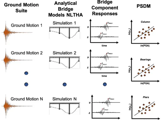
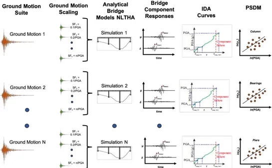
The seismic methodology of probabilistic risk analysis (SPRA) (Kennedy et al., 1980; Wakefield et al., 2003) has, for decades, been the most commonly used approach to assess the seismic safety of nuclear structures. In the last few years, this methodology has also become popular to characterise the seismic behaviour of other civil structures (Hamburger et al., 2003, FEMA, 2012). It was developed by the Pacific Earthquake Engineering Research Center (PEER), with the name of Performance-Based Earthquake Engineering (PBEE). The PBEE methodology can be divided into four processes shown in Figure 3.1: hazard analysis, structural analysis, analysis of damage and loss analysis.
Figure 3.1: PEER-PBEE methodology. Reproduced from Krawinkler (2005).
In the hazard analysis, the seismic risk is evaluated for the structure site and for the ground-motion time histories, where intensity measurements (IM) correspond to different levels of hazard. In the step of the structural analysis, nonlinear time history
analyses are carried out to calculate the structure's response to ground motions of a given IM regarding drift, top displacement, floor response spectrum characteristics, or others Engineering application parameters (EDP).
During the damage analysis step, this EDPs are used together with the component fragility functions to determine the specific damage measures (DMs) for the components of the system. Finally, defined these DMs, it is possible to evaluate a series of variables, including operability, repair/duration costs and potential victims. These performance measures are referred to as decision variables (DV) as they serve to inform the stakeholders about performance for future decisions. The relationships between the fundamental variables in the PEER-PBEE framework Figure 3.2
Figure 3.2: PEER performance-based earthquake engineering framework.
Studies carried out in the last decade (Luco, 2002; Baker and Cornell, 2004; Tothong and Cornell, 2006) have shown that the PBEE procedure can be made easier by separating the assessment of the design ground motion levels (probabilistic assessment of seismic risk, PSHA), and that of the structural response due to design ground motion (i.e. evaluation of the probabilistic seismic demand, PSDA). Details of the methodology of the PSDA.
Each step of the process, from design to IMs, IMs to EDPs, EDPs to DMs and DMs to DVs, includes uncertainties and is treated probabilistically. The probabilistic expressions of the components of the PBEE methodology can be combined using the total probability theorem (Benjamin and Cornell, 1970) and expressed as:
𝜆(𝐷𝑉) = ' ' ' 𝑝[𝐷𝑉|𝐷𝑀]𝑝[𝐷𝑀|𝐸𝐷𝑃]𝑝[𝐸𝐷𝑃|𝐼𝑀]𝜆(𝐼𝑀)𝑑𝐼𝑀 𝑑𝐸𝐷𝑃 𝑑𝐷𝑀 23 456 53
3-1
where:
𝑝[. . |. . ] = Probability Density Function (PDF)
𝜆(𝐼𝑀)= Mean Annual Frequency of events with intensity IM
𝜆(𝐷𝑉)= Mean Annual Frequency of events with value DV of the decision variable Each function are an element of the analysis methodology:
- 𝜆(𝐼𝑀) is the results of the hazard analysis; - 𝑝[𝐸𝐷𝑃|𝐼𝑀] is the result of the structural analysis; - 𝑝[𝐷𝑀|𝐸𝐷𝑃] symbolises the damage analysis; - 𝑝[𝐷𝑉|𝐷𝑀] give back the loss analysis.
The analysis of equation 3-1 shows that it is possible to divide the problem of evaluation into the four basic elements of risk analysis, structural analysis, damage analysis and loss estimation, by introducing three intermediate variables: IM, EDP and DM. Successively, can use the integration on all levels of the selected intermediate variables to re-pair the elements. This integration allows the evaluation of the conditional probabilities 𝑝[𝐸𝐷𝑃|𝐼𝑀], 𝑝[𝐷𝑀|𝐸𝐷𝑃] and 𝑝[𝐷𝑉|𝐷𝑀] parametrically in a suitable range of DM, EDP and IM levels.
The hypothesis is that suitable variables are chosen (IM, EDP and DM) so that the conditioning information should not be "carried forward", for example, selected the
EDPs, the DM is conditionally independent of IM, else, IM should appear after the EDPs. The right way to choose the EDPs is that should be selected so that the DMs
and the DVs do not change even with the intensity, once the EDP has been specified. In the same way, it is possible to choose the Intensity Measure (IM) so that, once defined, the dynamic response (EDP) is not further influenced, for example, by the magnitude or distance from the source of the seismic event, which is already integrated into the determination of 𝜆(𝐼𝑀) (Krawinkler and Miranda, 2004).
3.1 Hazard Analysis
The PBEE analysis aims to guarantee that a structure can resist an assigned level of ground shaking while keeping a chosen level of performance. Because of the considerable uncertainty regarding the position, the size and the consequent intensity of the shaking of future earthquakes, it is difficult to define the parameters in a deterministic way. To quantify these uncertainties and match them to produce an
explicit description of the distribution of future earthquakes that could occur on a site, it is possible to use the Probabilistic Seismic Hazard Analysis (PSHA) (Cornell, 1968; Kramer, 1996; Baker, 2008).
The first part of the problem is the estimation of the annual rate exceeded of the IM. In other words, seismic risk analysis represents a link between seismic scenarios and the intensity of ground motion, shown in Figure 3.1. Traditionally, the probabilistic seismic risk analysis (PSHA) due to a point source is performed by evaluating the following equation (Cornell, 1968; McGuire, 2004):
𝑣 (𝐼𝑀 > 𝑧) = 𝑁<=>· ' ' 𝑓3(𝑀) A
3
𝑓A(𝑀, 𝑅)𝑃(𝐼𝑀 > 𝑧|𝑀, 𝑅) × d𝑀 × d𝑅
3-2
where:
R is the distance from the source to the site; M is the magnitude of the earthquake;
𝑁<=> is the annual rate of earthquakes with ma agnitude higher than or equivalent to the minimum magnitude;
𝑓3(𝑀)and𝑓A(𝑀, 𝑅) are the probability density functions representing magnitude and distance;
𝑃(𝐼𝑀 > 𝑧|𝑀, 𝑅) is the probability of observing an 𝐼𝑀 higher than z for a specified magnitude and earthquake distance;
𝐼𝑀 is the quantification of the characteristics of a ground movement that are important for the structural response.
The PSHA needs the definition of seismic sources close to the specific site and the characterisation of these seismic sources through proper probability density functions and recurrence models. After the definition of a series of earthquake scenarios, it is possible to evaluate the range of ground motion for every earthquake scenario, and the annual rate of each combination of seismic scenario and ground motion is calculated. The probability that IM exceeded z, 𝑃(𝐼𝑀 > 𝑧|𝑀, 𝑅), is obtained from the prediction equation of soil movement (GMPEs) and includes an implicit integration on the variability of the ground motion. The probability that the
IM exceeds z is given by:
𝑃 (𝐼𝑀 > 𝑧|𝑀, 𝑅) = ' 𝑓F(𝜀) × 𝑃(𝐼𝑀 > 𝑧|𝑀, 𝑅, 𝜀) × d𝜀
where epsilon (ε) is the number of standard deviations around the median, 𝑓F(𝜀) is
the probability density function for epsilon, stated by the standard normal distribution, and 𝑃(𝐼𝑀 > 𝑧|𝑀, 𝑅, 𝜀) is 0 or 1. In this formulation, 𝑃(𝐼𝑀 > 𝑧|𝑀, 𝑅, 𝜀) identifies earthquake scenarios and combinations of ground motion that lead to
IM
greater than z. The hazard equation 3-2 can, therefore, be written as:
𝑣 (𝐼𝑀 > 𝑧) = 𝑁<=>· ' ' ' 𝑓3(𝑀)𝑓A(𝑀, 𝑅)𝑓F(𝜀)𝑃(𝐼𝑀 > 𝑧|𝑀, 𝑅, 𝜀) × d𝑀 × d𝑅 F A 3 × d𝜀
3-4
Although this form is more complexed than Equation 3-1, it has the benefit of clearly showing that the risk integral takes into account the random variability in three main parameters of the earthquake of the scenario: magnitude, distance and epsilon (Gülerce and Abrahamson, 2010). Using equation 3-4, the annual rate of exceedance of any measure of ground motion intensity can be calculated using seismic source models and GMPEs suitable for the region.
Furthermore, based on the recent approach developed by (Bommer and Acevedo, 2004; Katsanos et al., 2010) and to be consistent with the probabilistic analysis of seismic risk, the selected earth motions should in principle be compatible with the combination of magnitude and distance that dominates the danger for a particular value of IM (Sommerville and Porter, 2005). It is now clear the important role of IMs in current seismic risk probabilistic analysis methods: quantifying the seismic hazard at the structure site.
3.2 Structural Analysis
In the PBEE method, structural analysis is done to determine the response of a structure at various levels of the earthquake hazard in a probabilistic way. To this end, a structural computational model must be developed. The parameters uncertainties present in the structural model (for example mass, damping, stiffness and resistance) can be considered by changing the properties in the model itself. However, it is worth mentioning that (Lee and Mosalam, 2006), using PEER-PBEE methodology, have shown that the variability of soil movement is more significant than the uncertainty of structural parameters in influence the EDPs.
For each level of earthquake hazard, nonlinear time history analyses are performed to estimate the structural responses with the selected engineering demand parameters
![Figure 4.9: Comparison of empirical fragility curves developed by Shinozuka et al. (2001) [S] and Yamazaki et al](https://thumb-eu.123doks.com/thumbv2/123dokorg/7198715.75416/63.892.233.657.270.565/figure-comparison-empirical-fragility-curves-developed-shinozuka-yamazaki.webp)