IMEKO International Conference on
Metrology for Archaeology and Cultural Heritage Lecce, Italy, October 23-25, 2017
Non-destructive Techniques for the Knowledge
and Conservation of Abbey-Castle at Santo
Stefano, Monopoli (Bari).
Angela Diceglie
1, L.M.M. Lorusso
2,
1Università degli Studi di Bari Aldo Moro , Piazza Umberto , Bari [email protected]
2Università degli Studi di Bari Aldo Moro , Piazza Umberto , Bari [email protected]
Abstract – In 2013, the University of Bari and the Center
for Aerial Photography Laboratory Consortium in Bari, under the scientific direction of Angela Diceglie , launched an interdisciplinary study entitled “The Territorial Context and the Abbey-Castle of St. Ste-phen of Monopoli (BA): Knowledge, Conservation and Development, which aims to ensure the preservation and survival of the site while respecting its identity and uniqueness. The project is divided into a plan of awareness, conservation and development. Knowledge plan has been developing through a campaign of historical-documentary investigations, design and survey efforts, and non-invasive diagnostic tests as termografic analysis and archaeological reconnaissance of the site. We are starting a new research with georadar so we can confirm data of church and the monumental complex. The goals are that we were able to reconstructed major phases of occupation of the site since prehistoric period until modern age; so gaining more insight into the architectural, geometric-dimensional, historical-critical and material-construction aspects of the fortified remnant and the site.
I. INTRODUCTION (A.DICEGLIE)
The aim of this contribution is to illustrate a synthesis of the results obtained from global archeology investigations (non-destructive investigations) through which, in the case of the study under examination, it was
possible to clarify some aspects of settlements, constructive constructions and degradation of the abbey castle of Santo Stefano. The good, located on the Traiana road 3 km SE of the coastal city of Monopoli and about 5 km from the archaeological site of Egnazia in the South
of Puglia, is known to have been from 1086 to 1317 a Benedictine monasterium et hospitale and from 1317 to 1806 seat of the Knights Gerosimitans. When the Order
of Malta terminates its jurisdiction, the Castle is purchased by private individuals, and today, after
various happenings of property passages and constructive renovations, is the residence of the De Bellis
family of Castellana Grotte. The research, aimed at the
restoration of the good, methodologically, firstly included an analytical phase that is a type of critical-cognitive,
articulated in archaeological and archival historical, geometrical-dimensional and material-constructive knowledge. It was therefore supported by surveys of its
own global archeology, such as archaeological knowledge of the area, site unrecognized reconnaissance and remote sensing (shot by low-helicopter in the nearby visible and infrared bandwagon, photo interpretation, thermographic surveys). Knowing and documenting every
aspect of the good has been the primary goal to be able to
Fig. 1. Aerial view of abbey Castle of Santo Stefano LCA
II. ARCHAEOLOGICAL KNOWLEDGE OF THE DEFENSE OF SANTO STEFANO (A.DICEGLIE,
M.E.L.LORUSSO)
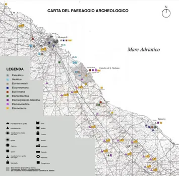
A first level of archaeological and comparative historical surveys was carried out on the anthropic landscape of the territory between Monopoli and Egnazia. The need arises from the hypothesis that the site of Santo Stefano has undergone a process of localization "similar" to that of
Monopoli and Egnazia, because of the same geomorphological structure (promontory extending between two eroded cascade at sea the blades). Hence the history of the archaeological historical studies resulted in a map of the anthropic attendance from the Paleolithic to the Modern Age of the study area, which comparing with the topographic surveys on the site has enriched the knowledge of the Santo Stefano site.
Figure 2. Map of the Archaeological Landscape between Monopoli and Egnatia
The topographic surveys carried out in the area corresponding to the "Plant of the All Terrain Surface, called the Santo Stefano Defense" represented in the Cabreo of 1748 (State Archives of Bari), which appears delimited to N by Porta Marzano, in Est from the Adriatic Sea, to the South from Lama Cannella and to the West from the Coastal Road The surveys used cartographic media (IGM, Aerofotogrammetric scale 1: 2000, iconographic archive sources such as the Cabrei of the Balloon of Santo Stefano) and helicopter shooting low altitude, which is fundamental to the areas of difficult access. Topographic reconnaissance was preceded by the relief of the artifacts for the purpose of studying their formal and constructive characteristics, which from the overall topographic survey for the planimetric restitution
of the hypogean settlement. The helicopter shootings supported the investigation. Comparing the IGM mapping and the Cabrei watercolor boards, sections of delimitation murals of the fief still in place and arcades (Marzano harbor N area) emerged, corresponding to old entrances to the feud. The surface reconnaissance has allowed to locate and document ancient structures and finds, with the aim of reconstructing the historical and archaeological picture of the area where the Abbey-Castello di Santo Stefano falls. The recurring element in the defense of Santo Stefano is the presence of ancient cisterns and ancient wells located even at small distances from each other. During the age of metals, groups of huts were present on the plateau of branch A of the knife, as evidenced by the piling holes found in the south direction and another arrangement, larger and structured, could be located on the coastal strip where tracks are hidden by the Castle. This hypothesis can not be ruled out, given the palyming holes found on the rock and, in the light of the above, from the data emerged from the comparison between the site of Santo Stefano, the village of the Bronze Age on the Egnatia Acropolis and the coevo located on the promontory of Monopoli. Certainly we can affirm a Roman age of the coastal area due to the presence of masonry in opus reticulatum in the basements of the Castle and in the garden towards the sea. Otherwise, Roman archaeological finds have not been found either in the Castle area or in the rocky settlement. Since the Middle Ages and throughout the modern age, the presence of a high concentration of archaeological material especially in the B branch of Santo Stefano blade leaves no doubt about the reorganization of the territorial structure and its intensive exploitation. The study of the grotto group no. 16-19 helped gather useful information for the reconstruction of the rock context and document the attendance of the area in the modern age. Particularly in Gr.19 were found fragments of frescoes referring to heraldic coats of arms of the Carafa family (16th century) [1]
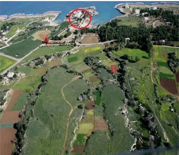
Fig. 3 Aerial view of Lama Santo Stefano
Fig.4 St. Stephen's feast plant (Valletta, National Library, AOM 6040, Cabreo of the Bishop of Santo Stefano) 1747-1748
III. REMOTE SENSING SURVEYS (A.DICEGLIE)
Remote sensing surveys carried out by low-helicopter and ground (in the visible band and near infrared), in particular on the church artifact, provided data not available with other detection systems. Compared with the data from direct investigations, archaeological investigations and documentary historical records, they are contributing to the knowledge of the constructive phases of the castle of Santo Stefano.
A first helicopter photographic survey campaign was carried out in 2013 and allowed, given the strategic location of the artefact, to identify parts of the monument that were not accessible. The images provided a comprehensive view of the product, which compared with the data emerging from other studies have clarified some of the latest constructive events of Santo Stefano (covering systems, in the environment built between the 19th and early 20th centuries, different from to the previous ones, types of wall weaving at different construction phases, the openings and blinds of doors and windows placed in places not fully accessible).
A second helicopter tracking campaign was carried out in February 2014 with the aim of obtaining information on the area of landslide sector B, no longer safe (see paragraph 1) [2].
In May 2015, the first low-helicopter thermal detecting campaign was carried out with a State Police helicopter with a FLIR thermocamera [3]. This remarkable campaign has enabled us to confirm the data from the historical-documentary and remote sensing through the reading of the different thermal responses of the blocks of buildings seen from above. It was in fact known to us that in the eighteenth century, with the arrival at Santo Stefano del Balì Francone, the most significant restorations were made, which still determine the architectural configuration of the artefacts, which can be traced back to three executive moments: "August 22, 1757-23 September 1758 for the apartment and the works of external accommodation; 3 November 1759-16 February 1760 for the arrangement of the enterprise above the Portone del Ponte; from the first September 1760 to August 1761 for the continuation of the remaining factories of the outer courtyard walls, to keep the castle closed and guarded by the sea. " Balì's intervention was thus a real restructuring project for the product, which was in an advanced state of degradation and disaster. Francone promoted a static consolidation of the Benedictine church through the construction of a "buttress", "... railing of lower and upper chambers ..." on N side, destined for a new residential apartment, since the oldest one , placed in E, was in a bad state of conservation [4]. The helicopter thermographic surveys confirmed that in the Block S (former Benedictine church and palace to inhabit Balì Francone) the wall texture corresponding to the roof plane has a different thermal response in the addition by Balì Francone in the 18th century, compared to that previous one. In addition, from these thermographs, it was possible to detect a series of thermal anomalies on the S facade of the church, related to its many refinements. In addition, in the courtyard the thermal discontinuities, indicated by the red circle of Fig., Have suggested that underground environments in opus reticulatum can continue even below the tread of the courtyard. [5]. The thermographic investigation of the manuscript compared with historical investigations and
archaeological investigations of architecture have documented, with different thermal responses, on the one hand the constructive events of the eighteenth century; on the other, the traces of the hidden wall structures-of which we do not yet know the length-visible to the naked eye in the basements below the church.
In addition, the thermographic investigation is helping to elaborate the thematic tables on the degradation of the structure of the building. The stone, used since antiquity for the execution of the structures, was subjected, from the extraction, probably local - as can be seen from aerial images documenting traces of ancient quarries on the rock - to a continuous degradation of the chemical type and physical. From here comes the different thermal response of the building materials, replaced, reused or sometimes of new and different extraction.
From the point of view of factory transformations, the period between 1808 and 1960 is certainly the most important one.
Through documentary research carried out in the archives of Apulia and Campania (State Archives of Bari (ASB), Ministry of Cultural Heritage, Bari Notarial Archive (ANDB), Ministry of Justice, Notary Archives of Naples (ANDN), Ministry of Justice) It emerged that in the period between 1845 and 1879 the church was altered in its original appearance, reduced to the two central modules. Nowadays research suggests that the church probably originally was characterized by three domes on the axis. In 1879 it is known that the East dome is embedded in the private home and the remaining two, different from the first one in their structure, remain in the ecclesiastical artifact.
Fig.5 thermography to helicopter at low altitude in the infrared band near the prospectus S; prospect E; SO
prospectus; church roof top and view of the inner courtyard
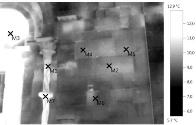
In 2015, a thermal earth mapping is carried out to support the data from the helicopter thermographic survey (professional Testo 885 camera, resolution 320 x 240
pixels, with optional extension to 640 x 480 Pixel Super Resolution technology and thermal sensitivity <30 MK). From a methodological point of view, the external shoots were made using solar source while in the church interior sources of artificial heat. The two-dimensional maps of
radiometric measurements, transformed by the
acquisition system into spatial temperature distribution images (thermograms), affected the most superficial outer layers of the architectural wrap (the accuracy in the restoration of wall textures and discontinuities present is a function of the thickness , typology and integrity of the plaster, the properties of the masonry materials and the amount of thermal stress), with a maximum depth penetration range of between 3 and 4 cm. These images were subsequently processed with IRSoft software for analysis, processing and storage of images captured by the camera. It has an integrated protocol generation system for a clear graphical representation of the data.The shootings were made on the Benedictine portal (West), on the prospect of the former church of Santo Stefano protomartire (South), on the prospect of the palace to live in Francone (East). In this case, the heat source used was the sun. In fact, shots were taken at different times of the day, selecting those made before the dusk - at the time of so-called "thermal inversion" during which the masonry investigated, previously exposed to the natural warming of the sun, escapes from the thermal equilibrium phase in which all the materials have more or less the same temperature) and begin to cool by yielding heat - in order to be able to better detect possible disomogeneities present in the various materials that make up the above structures. The thermograms were then resumed in the thermal inversion phase in order to detect the discontinuous distribution of the surface temperature of the masonry, due to the different thermal behavior In the I ° REPORT of the South Prospect it is possible to note from the thermal response of the wall studs that the points 1 and 2 correspond to the oldest part of the wall, while the points 3 and 4 are part of a more modern wall, perhaps corresponding to repairs carried out between 1845 and 1875.In conclusion, it is possible to assume that the western wall corresponding to the Benedictine portal at the top has been rebuilt with calcarenic material similar to that of the upper prospect of the south wall (where the chains introduced in the XIX century after the resizing of the church are located) . Also always on the south wall, the thermal response of the bottom does not find comparisons with other points of the artifact. The thermal shots made inside the church showed other data below the subtle plaster state: wall textures of different typology; a walled monofora (visible also outside and without relation to the compositional aspects of the span in which it is inserted); an abnormality of the wall texture in the south, referring to a burial. In the I ° REPORT of the South Prospect it is possible to note from the thermal response of the wall studs that the points 1 and 2
correspond to the oldest part of the wall, while the points 3 and 4 are part of a more modern wall, perhaps corresponding to repairs carried out between 1845 and 1875.In conclusion, it is possible to assume that the western wall corresponding to the Benedictine portal at the top has been rebuilt with calcarenic material similar to that of the upper prospect of the south wall (where the chains introduced in the XIX century after the resizing of the church are located). Also always on the south wall, the thermal response of the bottom does not find comparisons with other points of the artifact. The thermal shots made inside the church showed other data below the subtle plaster state: wall textures of different typology; a walled monofora (visible also outside and without relation to the compositional aspects of the span in which it is inserted); an abnormality of the wall texture in the south, referring to a burial. In the 1° REPORT of the South Prospect it is possible to note from the thermal response of the wall studs that the points 1 and 2 correspond to the oldest part of the wall, while the points 3 and 4 are part of a more modern wall, perhaps corresponding to repairs carried out between 1845 and 1875. In conclusion, it is possible to assume that the western wall corresponding to the Benedictine portal at the top has been rebuilt with calcarenic material similar to that of the upper prospect of the south wall (where the chains introduced in the XIX century after the resizing of the church are located). Also always on the south wall, the thermal response of the bottom does not find comparisons with other points of the artifact. The thermal shots made inside the church showed other data below the subtle plaster state: wall textures of different typology; a walled monofora (visible also outside and without relation to the compositional aspects of the span in which it is inserted); an abnormality of the wall texture in the south, referring to a burial.
Fig. 6 Thermographic relief of a section of church wall S
Fig.7 Thermographic relief of the Benedictine portal E
Fig.8 External georadar relief courtyard CITATIONS AND REFERENCES
[1]. A. Diceglie, "Lama Santo Stefano Monopoli-Ba" in Albano Ottavio (edited by), "Reflections from Puglia. V. ", Espresso Group, Rome 2015, pp. 62-83.
[2]. A. Diceglie "First Considerations on the Rock Settlement of Lama Santo Stefano (Monopoli BA)", in "Taras. Archeology Magazine ", XXXIII, 2014.
[3] A.Diceglie "The Contribution of Remote Sensing Investigations to the Cantiere of Knowledge of the Monumental Monument of Santo Stefano Monopoli-Ba" in AA. VV., Thematic Conference of Biology and
Archeobiology from Knowledge to Preventive
Conservation (Palermo, March 19-21, 2015), c.s .. [4] N.D’Amico, "Monumental and Political Testimonials of the Ballad of St. Stephen in the Light of Relations with Rhodes and Malta", Ph.D. thesis in Comparative Art History, Civilizations and Cultures of Mediterranean Countries, Cycle XXIV , (SSD: L-ART / 01, ICAR 18), University of Bari, 2013
[5] A.Diceglie, "The Phases Historical - Architectural Abbey of Santo Stefano Monopoli (Bari) for the Project of Conservation", in Acts of the Conference HERITAGE
2016 - 5th International Conference on Heritage and Sustainable Developing, 12th to 15th July 2016, Lisbon , Portugal.
REFERENCES
[1]. M. Calattini , "Grotta delle Mura, Monopoli", in "Taras" 1999, Bari, pp. 4, have been consulted for information on the populace of the Paleolithic age in this territorial area. 26-27; Cala Corvino Fields (Monopoli - Bari)", in "Acts of the XXV Scientific Meeting, Italian Institute of Prehistory and Protostoria", 1984, p. 2; Palma di Cesnola Arturo, "Grotto of the Walls at Monopoli", Florence, 1967.
[2] L'Abbate Vito (ed.), "Society, Culture, Economy in Medieval Apulia", Acts of the Conference of Conversions (Conversano, 13-15 May 1983), Bari 1985; Id. (Edited by), "The territory southeast of Bari in the medieval age. Societies and Environments ", Catalog of the exhibition (Conversano, Civic Museum, May-October 1983), Fasano 1983.
[3].A. Cinquepalmi, "Historical Center (Monopoli, Bari)", in Documents of the Bronze Age, Research along the Puglia Adriatic Coast, Ministry of Cultural and Environmental Heritage, Archaeological Superintendence
of Apulia, National Museum of Egnatia, Fasano 1998, pp.101-103;
[4]. F. Pratilli, "Applied Way Approved and Described From Rome to Brindisi", In Naples, Di Simone, 1745, p.54 [5] G.Bertelli, (edited by), "Masseria Seppannibale Grande in Agro di Fasano (Br)", Bari 2011
[6] E. Lattanzi, "Topographical and Urban Problems of Old Egnatia", in "Cenacolo", IV (1974)