i
UNIVERSITA’ DELLA CALABRIA
Dipartimento di Ingegneria Informatica, Modellistica, Elettronica e Sistemistica
Dottorato di Ricerca in
Information and Communication Technologies
CICLO
XXXI
DISCOVERING THE “WORLD CITY”:
FROM TEXTS' ANALYSIS TO 3D SCENES VISUALIZATION
Settore Scientifico Disciplinare
M-STO/08
Coordinatore: Ch.mo Prof. Felice CRUPI
Firma______________________
Dottorando: Dott./ssa Valentina BOVA
Firma _____________________ Firma _____________________________
ii
Dedicated to life, which never ceases to surprise us…
iii
Contents
Abbreviations
vList of Figures
viList of Tables
ixIntroduction
1I. Three-dimensional Computer Graphics in the Cultural Heritage field:
Objectives and Potentialities 2
II. Work Aims and Motivations 3
III. Text-to-3D-Scene Application Cases 5
IV Outline of the Thesis 8
1. Case Study: “The World City”
81.1 Introduction 8
1.2 The ideal Cities 8
1.3 The World City Project 10
1.3.1 Andersen Project 11
1.3.2 Le Corbusier Project 16
2. Corpus Creation and Analysis
232.1 What is a corpus? 23
2.2 Corpus Construction and Contents 24
2.2.1 Corpus Composition from Sources 25
2.2.2 Construction of the four Sub-Corpora 26
2.3 Sentence Extraction 27
2.3.1 Evaluation of the Results 32
2.4 Sentences-corpus compilation 33
3. Spatial Information Extraction
343.1 Introduction 34
3.2 Motivation and Challenges 34
3.3 Spatial Information Extraction Methodologies 37
3.4 Human Language VS Computer Code 37
3.5 Natural Language Processing 38
3.5.1 Language Analysis 41
3.6 Spatial Annotation Scheme 46
iv
3.6.2 Qualitative Spatial Representation 50
3.6.3 Spatial Descriptions 53
3.6.3.1 Simple Spatial Descriptions 53
3.6.3.2 Complex Spatial Descriptions 57
4. Text Annotation
604.1 Annotation task 60
4.2 MAE (Multi-document Annotation Environment) 61
4.2.1 Document Type Definition (DTD) file 61
4.3 DTD scheme 64
4.4 From the annotation to the automatic spatial role labels and
relationships detection 67
5. Spatial Relationships Detection
685.1 Introduction 68
5.2 Saul structure 68
5.2.1 Data Representation 69
5.3 Knowledge Acquisition 70
5.3.1 Mapping sentences 71
5.3.2 Spatial Role Labelling (SpRL) 71
5.3.3 Spatial Qualitative Labelling (SpQL) 74
5.4 Constraints and Features 75
5.4.1 Constraints 75
5.4.2 Features 76
5
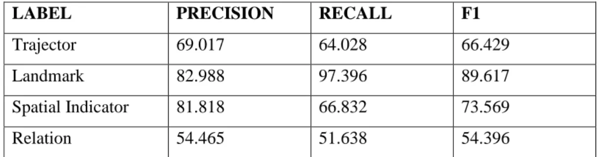
.5 Evaluation of the Results 785.5.1 Experimental Results 79
6. The three-dimensional representation
846.1 Introduction 84
6.2 Innovative Computer Graphic Applications 85
6.2.1 Related works 86
6.2.2 Task Definition 91
6.2.2.1 Basic Spatial Knowledge 91
6.2.2.2 Spatial Preposition Meaning 92
6.3 Proposed Framework 94
6.4 Virtual Reconstruction and Graphical Tools 96
6.4.1 BIM: Building Information Modeling 97
v
6.4.2.1 World City 3D Models 107
6.4.3 3D Scenes Composition in Blender 112
6.4.3.1 Why use Blender 113
6.4.3.2 Blender Reference System 113
6.4.3.3 Spatial Indicators Definition 115
6.5 Scene Generation System 135
6.6 Visual Results 136
6.6.1 Evaluation of the Visual Results 147
6.6.1.1 Subjective Evaluation: Evaluation Questionnaire 147
6.6.1.2 Objective Evaluation: Position Discrepancy 149
6.6.2. Comparison with WordsEye outputs 153
6.7 Limitations and Highlights of the System 159
6.7.1 Limitations 159
6.7.2 Highlights 160
7. The World City on the Web
1627.1 Introduction 162
7.2 Web Page Creation 162
8. Conclusions
1728.1 Summary of the Study 172
8.2 Contribution 174 8.3 Future Works 175
Appendix A
178Appendix B
183Appendix C
186Appendix D
196Bibliography
205Ackowledgments
212vi
Abbreviations
Symbol Description
ICT Information and Communication Technologies IE Information extraction
POS Part-of-speech tagging NLP Natural Language Processing
DT Determiner
NN Noun, singular or mass
VBZ Verb, 3rd person singular present IN Preposition or subordinating conjunction $PRP Possessive pronoun AI Artificial Intelligence CG Computer Graphic AR Augmented Reality VR Virtual Reality tr Trajector lm Landmark s_i Spatial Indicator
vii
List of Figures
Fig. Description Page
1 Illustration of Andersen World Centre, in H. C. Andersen, and E. M. Hébrard et all., “Creation of a World Centre of Communication”, Paris, 1913, p.I.
12
2 Illustration of Andersen World Centre, in H. C. Andersen, and E. M. Hébrard, “Creation of a World Centre of Communication”, Paris, 1913, p.XIIX
12
3 Elevation of the Tower of Progress, in H. C. Andersen, and E. M. Hébrard, “Creation of a World Centre of Communication”, Paris, 1913
14
4 Perspective of the Congress Square, in H. C. Andersen, and E. M. Hébrard, “Creation of a World Centre of Communication”, Paris, 1913
15
5 Plan of the Congress Square, in H. C. Andersen, and E. M. Hébrard, “Creation of a World Centre of Communication”, Paris, 1913
15
6 Mundaneum lands seen from Saconnex; in the background Le Corbusier traces the outline of Mont Blanc; March 1928, ©AFLC 2461
17
7 Schematic plan of relations between the individual parts; December 1927,
(©AFCL 24574)
18
8 Axonometric perspective on the entire project with numeration; Chinese ink; Leather trasing; 1,36 x 1,07; Archives of the "Fondation Le
Corbusier"; Paris (©AFLC 24525)
19
9 Study drawing, plan and a couple of elevations of the Museum; drafts, calculation and notes; coloured and black pencil; 0,67 x 1,09 ; Archives of
the "Fondation Le Corbusier"; Paris (©AFLC 24579) 20
10 Three elevations of the Museum with shape; study calculations; coloured and black pencil; 0,67 x 1,09 ; Archives of the "Fondation Le Corbusier"; Paris ((©AFLC 24563)
20
11 Study drawing, plan, section and elevation showing the museum with legend; coloured pencil; scale 1:500; Chinese ink; 1,11 x 1,40; Archives of
the "Fondation Le Corbusier"; Paris (©AFLC 24510) 21
12 Perspective of the site; July 1928, (©AFCL 24584) 22
13 Schematization of the results 32
14 Parse tree representation 43
15 Dependency-based parsing representation. 43
16 Words' different meaning, depending on the domain 44
17 Representation of the three linguistic FoR 48
viii
19 Representation of the Annotation Scheme 53
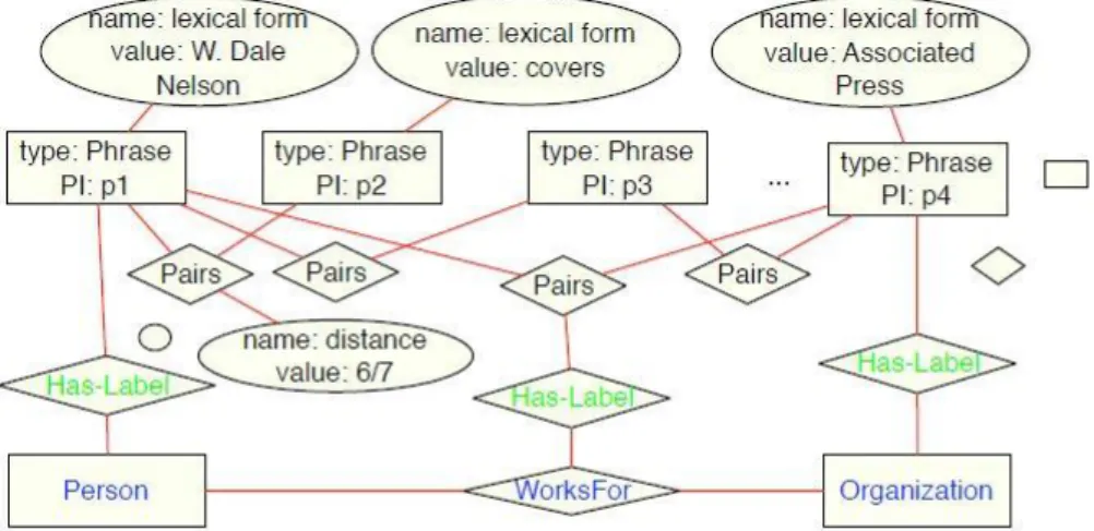
20 Representation of the data graph referred to the sentence “W. Dale Nelson
covers the White House for the Associated Press” 69
21 Representation of a part of model graph 70
22 Spatial ontology 72
23 Example of SemEval-1 benchmark 73
24 Representation of the concept of similarity 92
25 Representation of the rate of indeterminacy in a 3D scene generation 93
26 Connection between words and three-dimensional models 94
27 3D Scene Generation 95
28 Illustration of system architecture 96
29 Drawing, situation plan with legend and orientation; Indian ink; Leather tracing ; 0,63 x 0,90 ; Archives of the "Fondation Le Corbusier"; Paris (©AFLC 24521)
100
30 Drawing, plan of the project with museum; Black pencil; Study drawing; 0,74 x 1,11 ; Archives of the "Fondation Le Corbusier"; Paris (©AFLC 24604)
101
31 Drawing, Plan of the project with drafts and calculation; Black pencil; Study drawing; 0,73 x 0,87 ; Archives of the "Fondation Le Corbusier"; Paris (©AFLC 24605)
102
32 Ground floor: plan of the museum, library, university, with numeration and legend; scale 1:1000; drafts and calculation; Black pencil; Canson paper; 0,93 x 1,40 ; Archives of the "Fondation Le Corbusier"; Paris (©AFLC 24519)
103
33 First Floor: study drawing, plan with legend; scale 1:1000; drafts and calculation; Chinese ink; Leather tracing; 1,07 x 1,38 ; Archives of the "Fondation Le Corbusier"; Paris (©AFLC 24509) .
103
34 Building distribution according to the Golden Ratio; the explication of the relation A:B=B:(A+B)
105
35 Way to construct the golden rectangle 105
36 ArchiCADtoolbox palettes 106
37 ArchiCAD morph tool 106
38 Perspective view of the World Museum 107
39 Perspective view of the Library 108
40 Perspective view of the World University 108
ix
42 Perspective view of the Exhibitions of Continents 109
43 Perspective view of the Hall of Modern Times 110
44 Perspective view of the Stadium 110
45 Perspective view of the World City 111
46 Top view of the World City 111
47 Three-dimensional Cartesian coordinate system 114
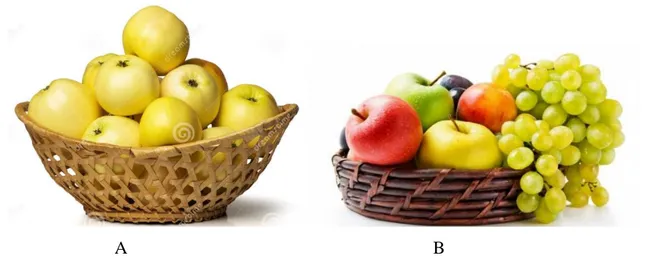
48 Representation of an object located in the centre of the virtual scene 115 49 Representation of “on” preposition where the apple is the trajector and the
box is the landmark
116
50 Bi-dimensional representation of the spatial indicator "on the left” 117 51 Representation of "on/to the left" preposition where the apple is the
trajector and the box is the landmark
118
52 Bi-dimensional representation of the spatial indicator "on the left of” 118 53 Representation of "in the centre of" preposition where the apple is a
trajector and the plane is the landmark
120
54 Bi-dimensional representation of the spatial indicator "in front of” 121
55 Bi-dimensional representation of the spatial indicator "before” 122
56 Bi-dimensional representation of the spatial indicator "behind” 123
57 Bi-dimensional representation of the spatial indicator “in the background” 124 58 Bi-dimensional representation of the spatial indicator “in the foreground” 125 59 Bi-dimensional representation of the eight possible configurations of the
scene after a trajector random translation
127
60 Bi-dimensional representation of the eight possible configurations of the scene after a trajector random rotation
128
61 Representation of “between” preposition where the apple is the trajector and the two boxes are the landmark
129
62 Illustration of the circumferences that circumscribe trajector’s and landmark’s shapes
131
63 Representation of “toward” preposition where the man is the trajector and the apple is the landmark
132
64 Illustration of the straight line passing through the X- and Y-axis origin 132 65 WordsEye 3D representation of the sentence “The Sacrarium is in the
centre of a forest of column”
154
66 WordsEye 3D representation of the sentence "The architect plans a composition where the Library is in front of the University”
x
67 WordsEye 3D representation of the sentence "The Library is in front of the University
156
68 WordsEye 3D representation of the sentence "Two symmetrical ramps, strictly linked to the platform, are located in the middle of the Mundaneum main square”
157
69 WordsEye 3D representation of the sentence "Two symmetrical ramps are located in the middle of the Mundaneum main square”
158
70 Error in "outside" usage 159
71 Le Corbusier’s plan 159
72 Wrong 3D scene generated by another system 160
73 HOMEPAGE representation 163
74 ABOUT section representation 164
75 Museum 3D representation on Sketchfab 165
76 GRAPHIC SOURCES section representation 166
77 Zoom of the images with details 167
78 TEXTUAL SOURCES section representation 168
79 LETTER section representation 169
80 3D SCENE section representation 170
81 CONTACT section representation 171
82 Association between a textual resource and an element of the 3D library in order to create the three-dimensional scene
xi
List of Tables
Fig. Description Page
1 Landmark possible positions. 30
2 Summarization of the four script steps 31
3 Evaluation metrics of precision and recall 33
4 Relational representation of the annotation scheme. 49
5 DTD file .representation 65
6 Results based on a general training domain corpus 79
7 Results based on a more specific training domain corpus 82
8 Results concerning the general type assignation 83
9 Correspondence between the spatial relations and the topological,
directional and distal relations 134
1
Introduction
I. Three-dimensional Computer Graphics in the Cultural Heritage field:
Objectives and Potentialities
Computational science and informatics are strongly linked to the representation of information in the way of texts, images and 3D models, which are able to increase user’s knowledge in diversified sectors. Among these types of data,3D models are certainly among the most complete and, consequently, suitable instruments to spread information. Moreover, the improvements made in 3D technology have not only revolutionized the way we see reality, but they have also broken down methodological and historical barriers.
3D representations can be considered containers of information of different nature and origin that, if isolated, have little value but can become complex and exhaustive if observed and analysed jointly. At the same time, the three-dimensional models may be “exploded” or decomposed in all their parts giving the possibility to observe and analyse all the components separately. That means that it is a study that goes from the more general to specific detail, and vice versa, trying to cover all aspects of knowledge.
The "3D" datum is now present in daily life both in terms of leisure and in many professional sectors. In fact, the 3D modeling technique is used to create virtual models of existing or non-existing objects, related to several fields such as mechanical, industrial, architectural, design or medical. Moreover, three-dimensional reconstructions, rendering, videos and applications of Augmented Reality and Serious Game have seen, in the last three decades, a large development in the field of Cultural Heritage [1]. The number of experimentations and case studies in this context, in fact, are quickly growing and a new discipline is being defined under the name of Virtual Cultural Heritage. It concerns the 3D reconstruction of historical places, either existing, no longer existing or never realised, and it allows users, scholars and historians to illustrate the synthesis of their studies and to discover the characteristics of
2
artefacts. In other words, all the works that in the past were shown to visitors through drawings or physical scale models are now made available to the users by three-dimensional elements located in a virtual world. The discipline that makes this possible is Computer Graphics, the science or the art of visual communication, which has several specific advantages such us:
• the possibility to offer three-dimensionality to a place or a project of the past; • the chance to make changes according to new research and discoveries;
• the opportunity to replicate, infinite times, the three-dimensional elements in order to use them for additional scientific, educational or communicative purposes.
II. Work Aims and Motivations
In this thesis work, the principal issue is not the “realism” of the three-dimensional representations or the simple transposition in 3D of works of the past, but the presentation of an emerging methodology, the tools and the applications used to create the 3D reconstructions together with all the difficulties associated with this aim. The abovementioned methodology, which will be discussed in Chapter 6, will be applied to a specific case study concerning the Cultural Heritage field in order to “give life” to a complex and incomplete project of the past and to spread its precious knowledge. The case study is the project of the “World City” [2], a city that, despite its historical and architectural importance, linked to the events and characters of the past that have affected it, is underestimated or, even, not recognized as a work forming part of the world cultural heritage. Therefore, this thesis work aims to provide an innovative tool able to transfer, through the use of 3D models corresponding to textual spatial descriptions, the knowledge of this complex project of high cultural value.
To conceive his project Otlet collaborated with important exponents of architecture, such as Hendrik Christian Andersen and Le Corbusier and, with each of them, he conceived a different project for composition and characteristics. Among the various projects, in this work, it has been decided to deepen more the one of Otlet and Le Corbusier because particularly documented through numerous written and graphic sources. The project, even though it was completely designed, was never realized and remained an utopian project. The World City was conceived by the architect as a very complex set of full and empty spaces able to respond to the emerging needs of the post-war period. Its planimetric organization aims, not only, to satisfy the functional criteria but also to face, for the first time, a political problem. The architectural project, in fact, aims to be a "turning point",
3
capable of making significant changes to a society full of imbalances and instability. The World City, therefore, identifies itself as an utopian city based on peace, on the exchange of knowledge and on the collaboration between men. In other words, a new alternative and better reality, able to distance humanity from a past full of discord, suffering and disparity. This is why the city is called to be, at the same time, a political and administrative center, an intellectual center (Mundaneum), a residential center (cité hotelier), a sports center (stadium) and an economic center, as well as a city with administrative autonomy.
The choice of using a three-dimensional virtual representation is based on the strong communicative connotation of 3D models, which facilitates a more rapid assimilation of the historical concepts with reference to both a specialist and not specialist public. Indeed, the power of the digital simulation of historical-cultural contents lies in the possibility of involving ordinary people, without historical or informatics skills, in successful learning processes that lead to a deep and lasting understanding of the information being communicated. The knowledge transfer takes place through new informative environments in which the users are stimulated thanks to the use of visualization and interfacing technologies. The methods or the tools used to create virtual worlds are numerous and aim to generate complex cognitive dynamics based on the spatial exploration of the data and the consequent comprehension of the information contained. The technique used and described in this work is the “text-to-scene generation”, a methodology which aims to create 3D scene reconstructions by interpreting natural language. This research area is not yet widespread or fully developed, but several studies are being carried out in this direction.
III. Text-to-3D-Scene Application Cases
Text-to-3D-scene-generation is an emerging methodology, which allows the creation of 3D environments without being extremely time consuming or requiring an enormous effort from the user, but directly from natural language descriptions. It permits to build three-dimensional scenes without learning specific graphical software, which require special skills and knowledge in the field of 3D modeling, and without spending an enormous amount of time in modeling objects. It is a versatile application, in fact, it can be useful in several areas and contexts, namely, to express designers’ creative aims, to show existing projects or artworks of the past, to facilitate scholarly learning and much more.
For instance, the methodology could be an interesting instrument to shape mental images and visual ideas or to materialise imaginary scenes born from writers’ fantasy [3]. The
4
advantage is that only in some occasions does the described setting really exist and the association between textual language and three-dimensional image is moderately simple, however, other times, the setting is the result of the writer’s fantasy and the reader can comprehend what the author writes only by using his imagination. Moreover, the comprehension is even more difficult if the text refers to a specific domain and, consequently, the three-dimensional visualization could be very problematic for non-expert readers. On these bases, the text-to-3D-scene-generation approach may simplify and explicit this association by assigning a shape to textual descriptions and generating the corresponding three-dimensional representation in a virtual space.
At the same time, the technique can be used to synthesize basic 3D object arrangements from user’s input examples. Precisely, once given an input descriptive sentence, the system can generate a plausible corresponding scene by learning from a larger scene database [4].The methodology could be a useful starting point to create new, different virtual scenarios which can be suitable for the most varied recreational or professional needs. For example, it could provide help to designers in the presentation of new ideas or projects because they could instantaneously create three-dimensional virtual environments starting from a textual description and they could modify them, according to the interlocutor’s preferences, by adding or removing descriptive details. In addition, the technique could also be intended as a way to allow the hypothetical buyers to materialize their project idea by themselves exploiting natural language descriptions and without any type of graphical software skills. Another remarkable applicative example of the 3D-scene-generation methodology concerns the knowledge acquisition process of children with intellectual deficits which cause thinking, communication and socialization problems [5]. Specifically, these children encounter serious issues in handling linguistic structures and, consequently, face problems in communication and socialization. On these premises, a text-to-scene conversion system can be a special support for children’s learning processes because it can be used as a computer-assisted teaching approach in the education of intellectually challenged children. The latter, in fact, cannot generally connect words to their meanings and shapes because they consider them abstract entities. Hence, the usage of a virtual representation may simplify the link between the two elements in order to give sense to the words present in the sentence and to provide a positive influence on children’s learning processes.
A further way to exploit the text-to-scene generation methodology, maybe the most ambitious, refers, once again, to the scholastic context where the students can have the possibility to mature and increase their algorithmic thinking [6]. Indeed, the rapid
5
development of information technologies in daily life implies the necessity of increasing people’s ability to think algorithmically, namely, to solve problems through a stepwise procedure. In spite of this, school education is principally aimed at teaching numeric computation, so, students are generally not able to: a) identify the problem exactly, b) subdivide the problem into sub-problems, c) plan a step-by-step solution. On this basis, a software tool able to help educators to teach algorithmic thinking may be an interesting solution [7]. In this scenario, the 3D-scene-generation technique can allow students to seethe three-dimensional representation deriving from a textual description and to study, simultaneously, the source code which generates the scene. In addition, they can change the location of the objects which appear in the scene and see how the code changes in order to understand the main programming language constructs and functions.
A last example of use of the text-to-3D-scene generation technique concerns the process of investigation and analysis of natural language visualization from a computational point of view. The main challenge is that machines do not have any cognitive ability and they need precise and complete instructions to understand human language, rich in ambiguity, polysemy and implicit information, in order to automatically generate a correspondent virtual three-dimensional representation [8]. An additional difficulty of the automatic visualization process is that the objects, existing in a described scene, are not often explicitly mentioned in the description because much knowledge about the world around us is obvious for men and for their mental abilities. For instance, if one says “The knife and the fork are,
respectively, to the right and to the left of the dish” he takes for granted that the interlocutor
understands that the dish and the cutlery are not put on the floor or on a bed but that they are located on a table. This means that, to create a system able to interact with people, it is necessary to investigate: a) how people use natural language to describe spaces and situations; b) which are the objects involved; c) which are object characteristics and locations and d) how to transfer human knowledge to the computer. On these bases, the text-to-scene generation technique could be seen as the result of a process of analysis of these aspects. Furthermore, it may be a connecting element between one-dimensional and three-dimensional information capable of “giving shape” to the words by transforming them into more or less complex 3D models. In this way, it would be possible to remove linguistic and domain barriers connected to the knowledge of word meanings or to the characteristics of objects referring to a particular field. Finally, it could be intended just as a form of learning about specific domain objects in their formal and functional characteristics and a way to enrich users’ knowledge with a strong visual impact.
6
Among the various application cases of the methodology, it has been decided to exploit the text-to-3Dscene-generation technique in the field of the Cultural Heritage. More specifically, virtual scenes have been created starting from descriptive sentences extrapolated from primary and secondary textual sources related to the World City project. This last aspect, that is the "nature" and origin of the texts, represents the innovative point of this thesis work, since the creation of 3D scenes did not start from sentences invented by the user or from documents without artistic or cultural value, but from texts referred to the World City. In this way, the aim is to spread the knowledge of a project which is a “piece of history” marked by an extraordinary historical, cultural and architectural importance. This topic will be dealt with in more detail in paragraph 6.2.1.
IV Outline of the Thesis
This thesis is divided into four main sections, each of them is characterised by a specific goal:
The first objective of the work was to collect all the sources regarding the “World City” (Chapter 1) in its two principal versions, which are Andersen’s original plan and subsequently Le Corbusier’s project. Once the relevant writings and drawings were collected a meticulous analysis was carried out in order to acquire a sound knowledge of the topic of study (§ 2.2). Consequently, all the buildings of Le Corbusier’s project have been modelled in three dimensions with the purpose of creating the 3D virtual models of the principal subjects of the utopian city (§ 6.4.2).
The second task was to create a link between the previously modelled three-dimensional elements, and the textual information describing the characteristics of the buildings and their locations in the urban space. This information has been automatically extracted from the original texts (§ 2.3) and simple 3D representations of the described scenes have been projected in a virtual environment. For this purpose, a rudimentary but efficient system able to transform a text written in natural language into a three-dimensional scene has been implemented (Chapter 5, § 6.3, § 6.5) and it has been used to virtually rebuild a masterpiece of the Cultural Heritage of the XX century: the World City Project. As already said, the city, due to its complexity and its highly utopian nature, was never built and it remained an unrealised dream, thus, this thesis work aims to provide an automatic reconstruction of it with the purpose of spreading its knowledge to all the users interested in world Cultural Heritage. Indeed, according to the Principles for the Conservation and Restauration of Built
7
Heritage it is known that “In the protection and public preservation of archaeological sites, the use of modern technologies, databanks, information systems and virtual presentation techniques should be promoted” [9]. Moreover, the relationship between the field of Cultural Heritage and Information and Communication Technologies (ICTs) could be exploited not only to represent sites and artworks of the past, or no longer existing, but also to illustrate projects which were designed and never realised. Therefore, the purpose here was to create a system able to generate, in an unusual way, virtual models useful to researchers to formulate conclusions about their studies or to general users to discover and understand the characteristics of their cultural heritage.
The third aim of the work was to generate an immersive three-dimensional reconstruction of the World City, aware that a 3D representation of the urban spaces, described and drawn by the authors, allows the users to have a better perception and knowledge of the project plan. People, in fact, could have the possibility to live personally in that “ideal piece of world” and to explore the City in all its parts discovering the marvellous buildings and the green areas. They could live an immersive experience and see the materialization of several descriptions contained in the historical books, publications and articles (§ 6.6). Furthermore, they could compare the original aim of the authors with their real impressions and suggestions and allow themselves to get wrapped up in the utopian atmosphere.
The fourth objective was to create a web page containing a good part of the material produced or collected concerning the project of the World City (Chapter 7). This page, although it is not yet present on the network due to problems related to copyrights with reference to downloadable texts, is intended as a large container ready to host an increasing number of sources, reconstructions, studies and everything that can spread the knowledge of the Otlet project to the most heterogeneous users. At present, it contains a series of references to graphic and textual sources, brief descriptions of the project, three-dimensional models and links to other Web pages or documents. However, the idea is to increase the content and, therefore, the importance of the page turning it into an instrument of knowledge and enhancement of an extraordinary work of our cultural heritage.
The ideal final task which, due to the lack of time in a doctoral process, has not yet been reached, should be the correlation between the three-dimensional models and all the documents and sources related to them. Only in this way will it be possible to have a global vision of the works in question in their geometrical, historical, urbanistic and symbolic aspects.
8
1. Case Study: “The World City”
1.1 Introduction
This chapter will present the case study of the work, the project of the “World City”, starting from an excursus of the precedent projects related to the concept of ideal cities. The “World City”, in fact, is an utopian city, born from an idea of a symbolic and considerable figure in the world of documentation: Paul Otlet1 [10]. He planned to create a City where people could live in harmony and in a universal cooperation; a place where enclose, at a global level, the great institutions of intellectual work: libraries, museums and universities. The evolution of Paul Otlet's concept of the World City (Cité Mondiale) was developed in the period from 1910 till 1941 and, to promote his idea, he collaborated, on different occasions, with several famous architects like Hans Christian Andersen and Ernest Hébrard, Octave van Rysselberghe, Louis Van der Swaelmen, Le Corbusier, Victor Bourgeois, Maurice Heymans and Stanislas Jassinski [11].
1.2 The ideal Cities
The ideal city is a planned, real or utopian city whose urban organization responds to precise philosophical, scientific and rational criteria.
In the ancient Greek era the philosopher Plato theorized an ideal city which was able to mirror the kosmos, on the one hand, and the individual on the other. He described the ideal polis as a city based on justice and human virtue, a form of social and political organization that allowed individuals to maximize their potentialities, serve their fellow citizens, and live in accordance with universal laws and truths. Plato theorized the ideal polis from a political
1Paul Otlet (1868-1944), was an author, a lawyer, a socialist and pacifist militant. His will, as a visionary man, was to live
in a World characterized by peace and scientific progress. Moreover, he aimed to map out the world's knowledge and store it, through an archival system, into wooden cabinets. His idea and writings anticipated the advent of the World Wide Web, in fact, together with this friend Henri La Fontaine he laid the foundations of the Mundaneum, a sort of paper Google with pacifist principles. He founded the Union of International Association in 1910 (now located in Brussels) and he spent several years in the implementation of projects regarding the construction of an ideal society and an ideal city. In particular, in the early 1900s, he conceived an unrealised project of an “perfect” city, called, the World City.
9
point of view, indeed, he set a five-fold classification to describe how the city ought to be governed. In his idea, the best form of government was an aristocratic model based on the rulership of philosopher kings; the second form was the timocracy, founded on the leadership of an elite of guardians or strong men; the third type was the oligarchy, consisting of rules “by the few” and, the last two forms were the democracy and the tyranny which represented the rules “by the many”. The philosopher believed that the ideal polis had to be an enlightened city, based on the highest universal principles, that he called the “City of God”: a place where humans could aspire for the best and could look for inspiration and guidance in carrying out their worldly affairs [12].
Conversely to the theoretical Greek urbanization, the Roman one was founded on practical functionality, in fact, it was set on precise practical criteria, which included the organization of the settlement model [13]. In particular it was based on a checkered planimetry crisscrossed by two large streets, the “cardo” and the “decumano”, which converged into the centre of the city: the Forum.
The design of the ideal city mainly spread in the Renaissance when urban settlement assumed a new role linked to the centrality of man.
An urbanistic and architectural theorization of the ideal city characterized the Renaissance era in which the revaluation of classical art and the attention to the harmony and proportionality of the forms coexisted [14]. In this context Architecture became an instrument of centralization of man that triggered a process of transformation of the city role from a simple settlement or monumental function to an identity role. However, ideal cities could not be formed in reality, without political and economic support. Therefore, regular geometry and straight streets with a strong perspective of cities represented the power of early capitalism and the central state.
The concept of ideal city was re proposed, in the XX century, by the famous architect Le Corbusier2 who, not only elaborated, together with Paul Otlet, the project of the World City, which will be illustrated below, but also after the non-realization of it, continued to design utopian cities. Indeed, in 1935 published a treaty, named “La Ville Radieuse” in which he described a utopian city, functional and well organized. It was composed of both an
2Swiss architect, town planner and designer. Le Corbusier is considered one of the founders of contemporary architecture, as well as an exponent of the Modern Movement and Brutalism. He was the designer of several French private residences, such as the Ville Savoye, and of public buildings throughout the world. He was also the inventor of modern housing solutions, such as the Unitées d'Habitation, and was the creator of cities inspired by utopian visions. Finally, he invented furniture that became part of Western popular culture.
10
industrial and residential area, which occupied only 12% of the total soil, leaving the rest of the land to green areas. The street for pedestrians and the motorways would have been diversified and the public transport would have taken place underground. Some years later Le Corbusier was tasked to plan the city of Chandigarh, an Indian City, by the prime minister Nehru. The city should have been a symbol of harmony and hope and its urban structure should have contained several green areas among the buildings. The city was designed for half a million people, it should have been self-sufficient and its plant resembles the human body because the architect dreamed of a city on “human scale”. Its most famous monument is the big hand stretched out to the sky that was located in the centre of the city and represents a symbol of peace [15].
A last notable example of an ideal city project was based on an idea of a Belgian bibliographer, Paul Otlet, who thought about a city able to be the symbol of the feeling of unity between people. It should have been a centre of knowledge in which to preserve the memory of the entire world. The idea of the “World City” creation, from its implementation to the last project, received both approvals and controversies and it was changed or revisited several times.
1.3 The World City Project
The early 20th century was marked by rapid industrial, economic, social, and cultural changes. It was characterized by prosperity and economic growth on the one hand, and on the other by a rise in poverty and slums in major cities. The markers of the period were urbanization, architectural and scientific advances and the spread of goods and information. After these years of splendour a period of competition began between nations and the rivalry between European powers led to the outbreak of the first World War. In this way, from 1914 to 1918 the majority of the world’s states were characterised by destruction and death and the world became a site of terror. Thus, in 1919, soon after the end of World War I, the idea to create an “ideal place” in the middle of the Europe, which took the name of “World City” [2] arose. It should have been a city based on harmony and scientific progress and a self-sufficient city from a political, economic, social and intellectual point of view. The idea was to create a centre for professionals, philosophers, artists and scientists, in other words, a “place of world culture” in which gather to the traditional institutions of intellectual creativity and enhance the peaceful use of knowledge.
11
This new city presents itself as a collection of elements scattered in an immense green park near the lake. The project, which never had a precise location, even though, one of the places favored by Otlet was the city of Geneva, was unsuccessful because it was rejected by the Geneva authorities for reasons of too high costs, both because of the Nazi invasion in the 1940s, which reduced the Otlet project to nothing, because it was considered harmful. The "international city", also known as the 'new Geneva', was called to materialize the dream of building a place that must accommodate all world knowledge and in which humanity could recognize itself. The idea was to create a symbol of unity and brotherhood and a place of the globe where the image and the meaning of the world may be perceived and understood. It should have been a “home for men” after the war, construed as an experiment in organizing and introducing order and permanent peace to a world-wide society [16]. In addition, it should have been a monument to contemporary man and an extension of the present highest institutions of intellectual and cultural life.
As cited before, Paul Otlet collaborated with numerous famous architects in order to design the complex project of the World City and, each of them, elaborated their own spatial representation of it. All the projects, in fact, are characterised by different aspects from an architectonical, urbanistic and geographical point of view.
1.3.1 Andersen Project
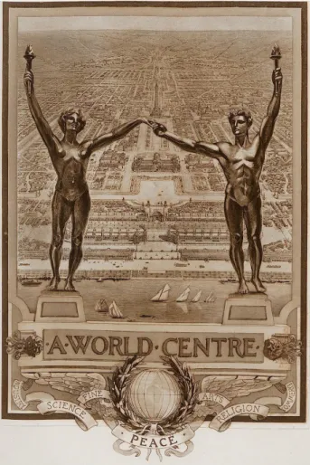
In 1913 Hendrik Christian Andersen, a Norwegian sculptor, published a book titled “Creation of a World Center of Communication” [17] where he set up his idea regard the construction of an international city (fig.1,2).
12
Figure 2: Illustration of Andersen International World Centre, H. C. Andersen, and E. M. Hébrard, “Creation of a World Centre of Communication”, Paris, 1913, p. XIIX.
Figure1: Illustration of Andersen World Centre, in H. C. Andersen, and E. M. Hébrard., “Creation of a World Centre of
Communication”, Paris, 1913, p.I. .
13
In the first part of the book he talked about the history of the most important architectural complexes of all ages, from prehistoric to modern times, and he found in the past the best and most comprehensive organization. Andersen structured his book alternating drawings and theoretical reflections and, most likely, his idea was inspired by the American transcendentalist philosophy. Indeed, he believed that the human’s path goes through the attainment of peace and harmony between men. The sculptor established a collaboration with the French architect Ernest Hébrard to whom, at first, he gave the task to design a fountain to place in a public square in the centre of the city. Several pages of “Creation of a
World Center of Communication” are dedicated to the “fountain of life” which should have
been one of the most important symbols of the City, in fact, the flow of the water represents the continuous flow of human’s life that, day after day, goes from sunrise to sunset. It should be noted, however, that in the book the link between the fountain and the idea of the World City remains undefined.
The complex project of Andersen and Hébrard, which lasted about nine years, was known to an architecture historian, Urbain Ledoux, who, aware of the will of Paul Otlet and Henri La Fontaine to build an international center for international associations, decided to inform them. Therefore, when the latter went to Paris in 1912, the drawings were almost completed and they had the possibility to see them. Their impressions were positive and they expressed the appreciation for the idea and to the structure of the city, in fact, although the project was not yet finished, it was presented in a meeting of the Union of International Associations in April 1913.
The World City did not have a precise geographical location because, in this way, the architect would have been able to express his ideas freely, without any types of restrains. The only certain thing was that the City should have been built near the sea in order to be a point of convergence of all the sea-routes of the globe.
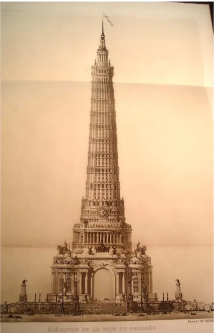
Hébrard’s city is structured along an axis of symmetry that aligns a monumental centre, some directional areas and a big station while, all the other elements of the plan, are distributed with respect to this axis in a specular way. The residences and the health care establishments are located on concentric zones around a monumental area where a symbol of the city the
14
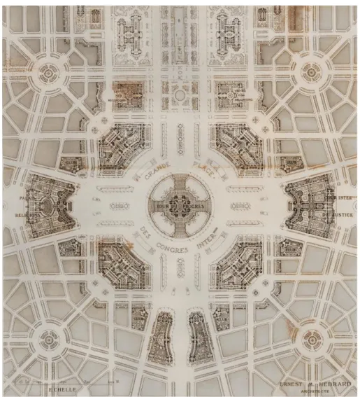
It is the dominant element located in the middle of the “Congress Square” (fig.4,5), a circular square inscribed in a square-shaped one, where big boulevards converge and where, in each corner, one of the four Congress Buildings are set.
Figure 3: Elevation of the Tower of Progress, in H. C. Andersen, and E. M. Hébrard., “Creation of a World Centre of Communication”, Paris, 1913.
15
Figure 5: Plan of the Congress Square in H. C. Andersen, and E. M. Hébrard., “Creation of a World Centre of Communication”, Paris, 1913.
Figure 4: Perspective of the Congress Square, in H. C. Andersen, E. M. Hébrard, “Creation of a World Centre of Communication”, Paris, 1913.
16
A bit further away from the centre two parks and several sports facilities overlook on the seafront while, on the opposite area with respect to the axis of symmetry, some industries and services are placed. To conclude, a navigable channel surrounds the urban area.
Andersen, aware of the interest of the regimes in his project established a relationships with Benito Mussolini who, in 1926, after a meeting with the sculptor, offered for free a land near Rome for the construction of the World City. Paul Otlet, as a great pacifist, was not enthusiastic about the news, furthermore, he did not agree with his megalomaniac and idealistic attitude, so, he decided to abandon the project and to start a new relationship with a reknowned architect: Le Corbusier.
1.3.2 Le Corbusier Project
During the first months of 1928, the Belgian bibliographer communicated with the Le Corbusier and Jeanneret architectural firm, sited in Paris, to propose the design of a new World City to be built in Geneva. Otlet already knew Le Corbusier and he shared his architectural style and inspiring principles. Furthermore, he appreciated the ability to assert his ideas. These are the reasons why he decided to contact him to present the project on which he worked for many years, together with Andersen, without ever seeing it realized. The great project should have been managed by an association of friends belonging to several European capitals and numerous buildings such as a library, a museum, scientific associations should have been included. The core of an even vaster project should have been the Mundaneum and its planning took place between 1928 and 1930, within a complex set of related events. Le Corbusier's work could be distinguished in two different consecutive periods, which lead to the definitive formulation of the project. The first phase ran from March to September 1928 and ended with the publication of a brochure published by Otlet [18], which contained the motivations of the idea, a description of the architectural project and drafted by Le Corbusier. The second phase, instead, lasted from September 1928 to August 1929 and was characterised by a large revision of the project itself.
17
The internationalist ideology of Otlet and the ambitions of its program forced Le Corbusier to put a particularly intense effort on the project. Indeed, already in 1926, during the preparatory phase of the project, he had studied the entire area of the hill drawing the highest site on the Morillon plateau under the village of Saconnex (fig.6).
There are not any documents evidencing an inspection made specifically in the site of Geneva, therefore, Le Corbusier probably worked "from memory" on photographs and drawings.
During a meeting in Brussels, Paul Otlet presented to Le Corbusier and Pierre Jeanneret, the results of many years of work with the architect Hébrard and the sculptor Hendrik Andersen on the construction of the "World Center”; subsequently, Le Corbusier was asked to give shape to a large museum, a library, a centre of the International Associations, an international university and, finally, a large natural park with sports facilities, a residential center, a railway station and an airport.
The institution of the Mundaneum, according to Otlet’s idea, should not have been a traditional complex of buildings but an immense emblematic space. To better describe his idea, he made a sort of synoptic table, called "plan forms" (fig.7), which was used by Le Corbusier as guidelines to develop his future project.
Figure 6: Mundaneum lands seen from Saconnex; in the background Le Corbusier traces the outline of Mont Blanc; March 1928, (©AFLC 2461).
18
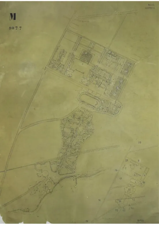
The forms, represented in the drawing, can be easily reduced to the figures of the circle, the square and the triangle, arranged inside a grid, which summarize the meaning of precise functions. Le Corbusier, then, made a three-dimensional transposition of these shapes which became a cylinder, a cube and a pyramid. The buildings of the Mundaneum were characterised by complex ideological contents which explains the articulated and structured genealogy of Le Corbusier’s last project (fig.8,9,10,11).
Figure 7: Schematic plan of relations between the individual parts; December 1927, (©AFCL 24574).
1. Sacrarium; 2. Globe; 3. Hall and centre; 4. Museum; 5. Associations Offices; 6. Nations Offices; 7. Library stores; 8. Temporary expositions; 9. Peace building; 10. Stadium; 11. Cinema; 12. Diorama; 13. Station; 14. Business centre; 15. School centre; 16. City pavilions; 17. Autonomous institutes; 18. University residences; 19. Natural garden; 20. Museum: Asia and Europe sections; 21. Museum: Americas Asia and Oceania sections.
19
For example, the Museum of human creation, which is the most important building of the complex, had the shape of a spiralling pyramid to respond to “the absolute continuity of events in history” [19].
Figure 8: Axonometric perspective on the entire project with numeration; Chinese ink; Leather trasing; 1,36 x 1,07 ; Archives of the "Fondation Le Corbusier"; Paris (©AFCL 24525).
20
Figure 9: Study drawing, plan and a couple of elevations of the Museum; drafts, calculation and notes; coloured and black pencil; 0,67 x 1,09 ; Archives of the "Fondation Le Corbusier"; Paris (©AFCL 24579).
Figure 10: Three elevations of the Museum with shape; study calculations; coloured and black pencil; 0,67 x 1,09 ; Archives of the "Fondation Le Corbusier"; Paris (©AFCL 24563).
21
Furthermore, inside the Museum, Le Corbusier designed the construction of a Sacrarium, a symbolic monument which gave a place to the Spirit of History [20].
A precise location was assigned to the complex and articulated project. In fact, it was to be integrated into an already built environment characterised by many consolidated elements such as Saconnex, Pregny and Morilon (fig.12).
Figure 11: Study drawing, plan, section and elevation showing the museum with legend; coloured pencil; scale 1:500; Chinese ink; 1,11 x 1,40 ; Archives of the "Fondation Le Corbusier"; Paris (©AFCL 24510).
22
Its construction was initially financed by donation from wealthy individuals, governments, municipalities and institutions that were firmly convinced of the validity of a world centre for the accumulation, organization, and dissemination of knowledge.
23
2. Corpus Creation and Analysis
2.1 What is a corpus?
J. Sinclair [21] defined a corpus as “a collection of pieces of language text in electronic form, selected according to external criteria to represent, as far as possible, a language or language variety as a source of data for linguistic research”. Ideally, a corpus is designed to be representative of a language through careful selection, indeed, it is not simply a set of data but an organic and systematic collection of both oral and written material. In other words, the corpus can be formed of simple sentences, found in various contexts, or whole texts, recorded or transcribed, and this enormous amount of material, coming from heterogeneous sources, is provided in electronic form and it is incorporated into computerized databases. The corpora could be monolingual, bilingual or multilingual. The first one represents only one language while, the other ones, represent two or more idioms. A corpus may be open or closed with the difference that, the open corpora do not claim to contain all data from a specific area while, the closed corpora contain all or nearly all data from a particular domain. The choice of using one or the other model depends on the objective of the specific research project. In particular, if the corpus is to be used as an instrument to study the characteristics of a given language in a specific period of time, then the model to be preferred is the closed one, as it is able to offer a "snapshot of the state of a language" at a given time "[22]. On the contrary, if the goal of the corpus is to analyze the evolution of a language over time, the model to be used is the open one, as it able to reflect "the changing state of a language" [22].
A classic research question is how representative a corpus is and the answer depends on how capable it is of describing relevant aspects of the language. This means that corpus selection is a very important aspect both for corpus builders and corpus users, indeed, the knowledge obtainable from its use depends on the set of questions that can be investigated and on the composition of the corpus itself. The choice and creation of the corpus are essential steps because making mistakes in the choices of documents can affect all the subsequent work.
24
2.2 Corpus Construction and Contents
In this section, we will describe the corpus construction, which will be used to extrapolate sentences containing spatial information belonging to the architectural and urbanistic domain.
In particular, we focus on the following aspects [22]:
• Definition of the characteristics of the reference population from which a significant sample was extracted;
• Definition of qualitative and quantitative criteria for determining the representativeness of the corpus;
• Presentation of the composition of the corpus (types of documents, sources, etc.) and its dimension.
The corpus in question is a specialist multilingual corpus3 of written texts, formed by four sub-corpora, one for each language (French, English, Italian, Spanish), belonging to the same domain. The existing studies regarding the construction of document collections, present in the literature, are based on the key principle of corpus representativeness [24] with respect to the reference population. The corpus, in fact, must fulfil the role of a representative sample, in the statistical sense of the term, because all the observations obtained from its analysis must be valid and extendable to all the individuals of the population. In particular, the extracted terminology must be as representative as possible of the reference domain. This means that the collected material must form a significant set of the total documents of interest; in other words, the corpus must represent the population but on a smaller scale. One of the criteria that contributes to ensure the representativeness of the corpus is its size, however, there are not yet precise directives concerning the right dimension.
Given the large amount of information and documents in all areas of knowledge, determining the number of all the available sources, for a precise domain, is a difficult and significant issue.
With respect to the criterion of quality, in order to carry out proper terminology work, the texts have to meet several requirements [25]:
I. “The texts should be representative of the period taken into consideration”; II. “The texts should be written by different authors, experts of the domain”;
3 Multilingual corpora can be parallel and comparable. In the first case, the texts in their native language, are also available as translations into another language, while in the second case, the corpora do not include any translated texts.
25
III. “The texts should be original and not translations because, in this way, it is possible to ensure that the used terminology is appropriate and specialist”;
IV. “The texts, that compose the corpus, should be complete and not fragments of the whole documents”.
All these criteria should guarantee the maximum reliability of all the texts which form the entire corpus.
As previously mentioned, it aims to represent and analyse a particular domain, never analysed before for purposes similar to mine: the architectural field of the “World City” project. The collected documents concern the two most important and structured works of the utopian City, which are the Andersen and Le Corbusier’s projects. The two architects created their own version of the city, in fact, the former designed a more sumptuous and complex project, while, the latter, planned a smaller city based on a human scale. The two projects, despite their diversity, have some elements in common such as the ideological aims of the city construction or some buildings and institutions; Le Corbusier, in fact, analysed the prior Andersen project re-proposing some aspects and changing others.
2.2.1 Corpus Composition from Sources
Regardless of the unique characteristics of the two projects, both were the result of numerous years of study and research in which they implemented, modified and improved their idea. The work process, as well as the final project, is attested by several documents of different nature and origin.
Primary and secondary sources have been collected after a laborious and meticulous research. They are original books and publications by the authors, letters of correspondence between Paul Otlet and the architects, drafts and drawings, but also books, scientific articles or writings about the topic. The primary sources are stored principally in the archives of the Mundaneum4 sited in Mons, in Belgium, and in the archives of the “Fondation Le Corbusier”5, sited in Paris. Conversely, the secondary sources have been found in particular libraries, other archives or on the Net.
The set of these documents composed our corpus, which final purpose is to extrapolate from the texts all the spatial information regarding the setting and the configuration of the city.
4 <http://www.mundaneum.org/> 5 <http://www.fondationlecorbusier.fr/>
26
This permitted us to obtain numerous descriptive sentences which have been subsequently used to create a test and training dataset.
The corpus documents, as already mentioned, could be divided into primary and secondary sources; the first one are letters, books, publications written by Paul Otlet or the architects while, the second ones, are papers, books, journal articles or web documents related to the referent domain.
At the end of the analysis, we collected 29 texts in total, for an amount of 411.401 tokens6. The small number of documents depends on the fact that not much has been written about the spatial composition of the World City and increases their importance for the purposes of a spatial reconstruction of the city itself. These documents, originally of different formats (.doc, .pdf, .jpeg) have all been transformed in .txt files; in particular, in the last two cases, has been used the software ABBYY7, able to provide optical character recognition and document capture.
In the follow, a more specific description of the 4 sub-corpora is proposed.
2.2.2 Construction of the four Sub-Corpora
The English sub-corpus is the most numerous, in fact, the total number of texts amounts to17 units of different length, author and origin. In particular, the population is composed by:
a) an original publication by Andersen; b) one book;
c) six book chapters; d) five papers; e) one journal article;
f) one letter, the only one that describes the spatial configuration of the project; g) two web documents
for a total of 201,747 tokens.
The French sub-corpus is formed by 6 documents which are: a) two original publications by Paul Otlet;
6 Atoken is a linguistic unit or even a minimal unit of analysis. Thus, it can be represented by a word, a punctuation element, a date, a number or an acronym.
27
b) one book;
c) one book chapter; d) one journal; e) one paper
for an amount of 85,738 tokens.
The Italian sub-corpus has a total number of texts equal to 5: a) one book;
b) two book chapters; c) two web documents; for a total of 105,930 tokens
The last sub-corpus, the Spanish one, is formed by only 2 texts which are: a) one book chapter;
b) one paper
with an amount of 17,986 tokens.
We believe that the construction of a multilingual corpus is an added value for the representation of a domain knowledge and for information retrieval. The choice to build a comparable8corpus, in fact, ensures that we can work on “authentic” words and not on translations of the texts. This aspect responds to one of the qualitative criteria defined in [25].
2.3
Sentence Extraction
One of the most important functions of natural language is to describe spatial relationships between objects through linguistic constructs, which contain numerous references to spatial information. This type of information is easily understandable by the human mind but machines, on the contrary, do not have the same cognitive capacities. The main difficulty for a computer is to identify and extract only the right information from a
28
text, leaving out all the other content that, despite enriching the description, is not useful for the 3D scene generation.
In this thesis work, we generate a sentence extractor, written in Python programming language, capable of parsing large data to automatically extract specific sentences from the aforementioned corpus. The main aim is to allow people to automatically obtain the required data instead of reading the entire text to select precise information.
Spatial information is generally provided by the use of prepositions that establish a relationship between two or more objects. However, the same preposition could also be used to talk about events or situations which not involve spatial descriptions. For example, the preposition on is used to describe spatial configurations like “the picture is on the wall” or “the bottle is on the table” but, the same preposition, can be used additionally in completely different contexts such us “They need to concentrate on their studies” or “The discussion will be on a topic you have studied recently”. The first two sentences express spatial concepts, concepts of verticality or objects overlapping, while the last two sentences do not have any kind of reference to entities location. This means that the usage of prepositions depends on several aspects like the entities involved in the scene or the general situation of speech. In other words, prepositions are often used in front of nouns or pronouns to show the relationship between them and other words in the sentence, but they can also be used to describe the time when something happens (They arrived on Sunday), the way in which something is done (We went by train) and even more. On this basis, the identification and the extraction of particular sentences from a large number of texts characterised by heterogeneous information is a big and interesting challenge [26].
In this work, a script able to read and analyse a text with the purpose of extracting all the sentences containing spatial descriptions has been created. The latter are composed by three central concepts belonging to the Holistic Spatial Semantic Theory [27] in which the three main spatial roles are defined. They are trajector(s), landmark(s) and spatial indicator(s) that, linked together, generate a spatial triplet. In particular:
• the trajector is a spatial role label assigned to a word that denotes a central object of a spatial scene;
• the landmark is a spatial role label given to a word that signals a secondary object of a spatial scene (to which a possible spatial relation between two objects can be established);
• the spatial indicator is a spatial role label assigned to a word that indicates a spatial relation between objects (trajectors and landmarks) of a spatial scene.
29
To better understand, let us show an example:
The [car]TRAJECTOR is [under] SPATIAL_INDICATOR the [tree] LANDMARK.
where the ‘car’ is a trajector object, the ‘tree’ is a landmark object and ‘under’ is a spatial indicator.
A key element of the system is a set of text extraction rules that identify relevant information to be extracted from the input text. In particular, the adopted extraction process is based on some word lists belonging to a “spatial domain” and on specific rules which guide the system to identify only the sought information.
The system is subdivided in four sections which, by successive and interconnected steps, lead to a gradually more and more accurate result. The general idea is to start from an entire document, written in one of the four languages, and to parse it in order to identify the possible spatial indicators and labels (trajectors and landmarks) present in it. Of course, the interest is not to find these entities randomly located in the text but to find the sentences in which they are connected to each other. For this purpose, the system firstly divides the entire text in single sentences and, subsequently, analyses them to discard, step by step, those that are not useful for the final goal. The four parts of the system are the following:
1. Sentence_Split.py = the system opens a document, in .txt format, and separates strings using two specific delimiters, a dot (‘.’) or a long sequence of blank spaces. Then, it creates a .txt file (Sentences.txt) that collects all the sentences and writes them on individual lines.
2. Search.py = the system reads as input a .txt file containing all the possible prepositions or expressions that may be spatial indicators (ex. on, in the centre of, to
the right, …).Then, it opens a Sentences.txt file and it analyses if each sentence
contains or does not contain one or more spatial indicator(s). Finally, it creates, as output, a .txt file (outfile.txt) including only the phrases which contain spatial indicator(s).
3. CountOccurrences.py = the system reads two .txt files, namely, the previous
outfile.txt and domainNouns.txt which stores terms or multi-words that may be
trajector(s) or landmark(s) of the sentences. The latter are all written in lowercase therefore, the next step of the system is to replace all the capital letters, present in