KHAOULA BEN KHALIFA1*, CHAHIRA ZAÏBI1, JÉRÔME BONNIN2, PIERRE CARBONEL2, KAMEL ZOUARI3, THAMEUR MNIF1 & FEKRI KAMOUN1
1*Corresponding Author. GEOGLOB Laboratory, Sfax University, Faculty of Sciences of Sfax, BP 1171, 3000 Sfax, Tunisia.
E-mail: [email protected]; [email protected]; [email protected]; [email protected]
2EPOC, UMR 5805, Bordeaux University, Allée Geoffroy Saint-Hilaire, 33615 Pessac, cedex, France.
E-mail: [email protected]; [email protected]
3Isotopic and Palaeoclimatology Laboratory, National School of Engineers, Sfax, Tunisia. E-mail: [email protected]
To cite this article: Khalifa B. K., Zaïbi C., Bonnin J., Carbonel P., Zouari K., Mnif T. & Kamoun F. (2019) - Holocene environment changes in the Hachichina Wetland (Gulf of Gabes, Tunisia) evidenced by Foraminifera and Ostracoda, geochemical proxies and sedimentological analyses. Riv. It. Paleontol. Strat., 125(2): 517-549.
Abstract. Four sediment cores, drilled at Younga and Ouadrane Sebkhas (Hachichina wetland), were selected
for micropalaeontological, sedimentological, geochronological and geochemical investigation coupled to hierarchi-cal cluster and correspondence analysis. Our research aimed at reconstructing the past biodiversity, the Holocene palaeoenvironmental evolution and the responsible forcing. Subsurface sediments record four major phases: i) the first one is characterized by poorly to very poorly sorted silts, the dominance of the lagoonal/estuarine ostracod and the lagoonal/marine foraminifera and high values of terrestrial geochemical element ratios, such as K/Al and Fe/ Al, which indicate an estuarine lagoon; ii) two major marine transgressions, TR1 and TR2, allowing the settlement of widely opened lagoons towards 7160-8680 and 5070-5520 cal yr BP, are marked by the enhancement of the marine/ brackish ostracods and marine foraminifera, the improvement of species number, individuals number and H and E index values and of the marine element ratios such as Cl/Al and Sr/Al; iii) the opening of the lagoon is hampered by the action of drift currents allowing the genesis of sand spit and the settlement of a closed lagoon, towards 2610-3610 cal yr BP, characterized by the enhancement of lagoonal/estuarine ostracods and lagoonal/marine foraminifera and the increase of the individuals number; iv) the dominance of the lagoonal/estuarine ostracods and the lagoonal/ marine foraminifera and the decline of the species number and density mark a brackish lagoon, also characterized by very poorly sorted silts transported by uniform suspension, which evolves to the actual sebkha. This evolution, within a global climate alteration context, from an estuarine environment to the present sebkha passing by an opened lagoon, is linked to the complex hydrographic setting of the sebkhas and of the Ouadrane Wadi outlet discharging in the Hachichina wetland.
Received: September 11, 2018; accepted: May 17, 2019
Keywords: Sebkha; sea level; sand spit; Gulf of Gabes.
I
ntroductIonDuring the last decades, several proxies have allowed the reconstitution of Holocene climates and palaeoenvironmental evolutions and associated forcing. Globally, ocean surface reconstruction and estimates of sea surface temperatures are based on all predominant microfossil-based (transfer func-tions based on planktonic foraminifera, diatoms, dinoflagellate cysts, and radiolarians) and
geochem-ical (alkenones and planktonic foraminifers Mg/Ca) thermometers. On the other hand, geoarchaeologi-cal and geomorphologigeoarchaeologi-cal surveys (Slim et al. 2004; Marriner et al. 2012; Salomon et al. 2018), corals (Si-ringan et al. 2016), speleothems (Genty et al. 2006) and marine and lake sediments are the important paleo-archives used for paleoenvironmental stud-ies. The resolution of these paleoenvironmental records depends on the quality of these natural ar-chives. Marine sediments offer some unique aspects for paleoenvironmental studies because of the con-tinuity of the records. The resolutions provided are
at the millennial to centennial time scale. In order to unravel the highly diverse and interactive prop-erties recorded in marine sediments, geochemical methods (Giunta et al. 2001; Chagué-Goff et al. 2002; Martinez-Ruiz et al. 2015; Engel et al. 2016), sedimentologic approach (Benito et al. 2015; Do-nato et al. 2009), molluscs ecology (DoDo-nato et al. 2008), microfossil assemblages (Carbonel 1982; Mazzini et al. 1999; Zaibi et al. 2016; Frenzel & Boomer 2005) and multi-proxy study (Cuven et al. 2013; Wündsch et al. 2017; Khadraoui et al. 2018) have been used to develop proxies for paleoenvi-ronmental studies.
Ostracoda and Foraminifera are increasing-ly applied to reconstitute Holocene palaeoclimate and environmental changes as seasonal conditions, hydrodynamic levels or physical-chemical restric-tions at the water-sediment interface and tracing high resolution hydrological conditions (Ruiz et al. 2000a; Laprida 2001; Frenzel & Boomer 2005; Zaïbi et al. 2012, 2016). Their ecology and current distribution along the coastal fringe depend on ma-rine and continental influences. Therefore, they are considered the most reliable biological proxies for the Holocene paleoenvironment reconstruction in relation with anthropological and natural forcing. On the other hand, ostracods living in paralic and endoreic environments are excellent hydrological tracers in the fresh-salt-water transition areas.
Regarding the Holocene series, the main cli-matic and eustatic sea level variations have been reconstructed based on quantitative and qualita-tive ostracod distributions (Carbonel 1982; Boom-er & Godwin 1993; Mazzini et al. 1999; Sarr et al. 2009). The latter present reliable tools to recog-nize the different types of environments (Laprida & Bertels-Psotka 2003; Samir et al. 2003). Their eco-phenotypic variability and the stable isotopes and trace elements in their shells provide valua-ble information on present and past water salinity, temperature, chemistry, hydrodynamic conditions, substrate characteristics, climate, oxygen and nutri-ent availability (Carbonel 1982; Panieri 2003; Trian-taphyllou et al. 2003; Frenzel & Boomer 2005). The most important parameters controlling the benthic foraminifera distribution are food availability, dis-solved oxygen concentrations (De Rijk et al. 1999; Murray 2001), substrate type, temperature and salinity (Jorissen 1988; Samir et al. 2003; Hyams-Kaphzan et al. 2008; Phipps et al. 2010).
In Northern Tunisian coast, the analysis of ostracods and benthic foraminifera allowed the re-construction of the freshwater, marine, lagoonal and estuarine Holocene palaeoenvironments. Car-bonel & Pujos (1981) and Jouirou (1982) described the ostracods and foraminifera occurring in the sur-face and subsursur-face sediments of the lake of Tunis and lagoon of Bizerte and consisting of different assemblages of marine, open lagoon and closed la-goon environments (Fig. 1A). Ichkeul Lake, stud-ied by Stevenson et al. (1993), and revised by our team (Ben Hamad et al. 2018) by means of descrip-tive paleontological proxies, records seven periods of brackish and fresh waters, during the last 3000 years. Ruiz et al. (2006) studied the El Melah La-goon of Soliman and investigated its evolution to a future sebkha relying on the ostracod biozones. The Holocene evolution of Ghar El Melah Sebkha of Bizerte (Mansouri 1979), Korba Lagoon (Bouden et al. 2009) and Bou Zid Sebkha of Klibia (Farhat et al. 2010) seems to be controlled by the genesis of offshore bars. The Central Tunisian wetlands were studied by Ouda et al. (1998), Zaraï (2006), Amami (2010) and Henchiri (2014) who identified the different phases of humidity and aridity during the Holocene. The Gulf of Gabes coast is the most studied area via palaeontological proxies. In fact, Lachenal (1989) described Holocene assemblages of ostracods (phytal, opportunists and ubiquitous taxa) from the cores of the Gulf of Gabes and recognized the different regressive-transgressive phases. Zaïbi et al. (2011, 2012, 2016) examined the evolution of the South Skhira coast, by analyzing ostracods, foraminifera and molluscs and recog-nized the transgressive periods, the phases of sand spit genesis and the extreme events. Recently, Khad-raoui et al. (2018) investigated the Northern coast of Sfax and identified two transgressive events, a wet period of build-up of sand spits, the genesis of a closed lagoon and a tsunami event.
In the present study, we used a multi-proxy approach in order to pursue the following research objectives: i) retracing the evolution towards the present sebkha system via distinct phases of con-nectivity to the open sea due to Holocene sea level and geomorphological changes (based on geochem-ical, foraminifera, ostracods and grain size data);
ii) reconstructing changes in the terrigenous sedi-ment supply as an indicator of the long-term wadi discharge and rainfall variability at the Hachichina
wetland embayment during the last 7.5 kyr (using geochemical and grain size data), and iii) comparing this evolution to that of Tunisian and Mediterrane-an coasts.
G
eomorpholoGyandGeoloGIcal settInGThe Hachichina coast (Fig. 1B), characterized by a regular topography and a complex coastline, is located in the central part of Gabes Gulf at 3 Km to the South of Mahras City. The Hachichina wet-land has a warm and arid climate, with annual rain-fall of only about 150 mm, and semi-diurnal tides
ranging from 80 to 130 cm. This wetland shows the presence, from the North to the South, of three sebkhas named Younga, Ouadrane and El Kalba and associated lagoons and different zones with ge-omorphological characteristics, arranged from West to East as follows:
i) land characterized by the presence of several archaeological sites and developed vegetation with a succession, from East to West, of Salicornia and ol-ive plantations. The morphostructural map of this area reveals the presence of a corridor of N120-140 faults (Bedir 1995; Ghribi 2010) which control the deviation of an intermittent streams course, locally called Ouadrane and El Melah Wadis, oriented in E-W upstream and NW-SE downstream. Ouadrane
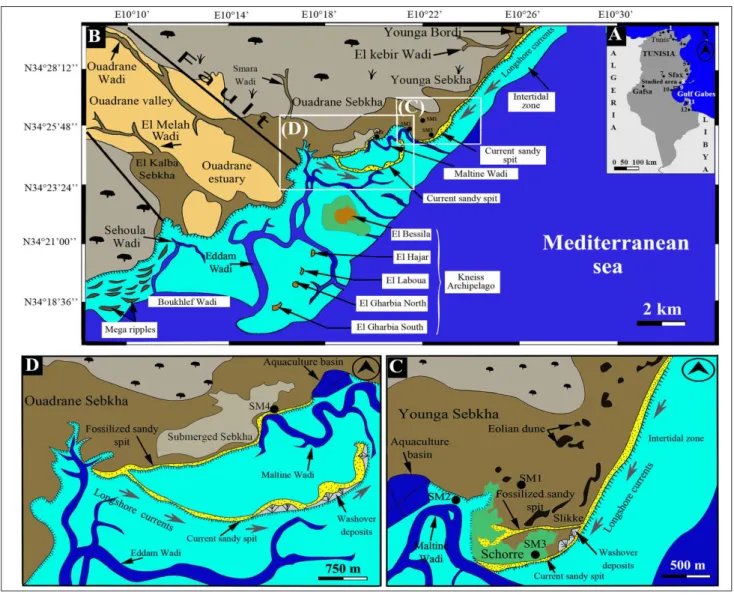
Fig. 1
-
A) Location map of studied area and positions of localities cited in the text. 1: Bizerte Lake, 2: Ichkeul Lake, 3: Tunis Lake, 4: KorbaLagoon, 5: Rass Dimass lagoon, 6: Ras Botria lagoon, 7: Maknassy area, 8: Gargour coast, 9: Hachichina wetland (studied area), 10: Dreiia Sebkha, 11: Bin El Oudiane Lagoon, 12: Boujmel Sebkha. B) Hachichina coast: Location of Ouadrane and Younga Sebkhas, distribution of different littoral environments, geomorphological units, position of Kneiss Archipelago and associated tidal channels (Google Earth, mission 2019). C) Detailed view of Younga Sebkha, distribution of different littoral environments, geomorphological units and positions of cores. D) Detailed view of Ouadrane Sebkha, distribution of different littoral environments, geomorphological units and positions of cores.
and El Melah Wadis feed the Hachichina wetland overland flow and allow the individualization of an important valley and estuary;
ii) a supratidal zone, corresponding to the sebkhas and extending over 2 Km landward. The surface sediments of the sebkhas are constituted by a centimetric level of gypsum overlying silty sands/clays rich with salt crystals. Younga Sebkha (Figs 1B and 1C), with an area of about 4 Km2 is limited in the North by the archaeological site Younga Bordj, characterized by the presence of several Roman ruins and El Kebir Wadi. It is en-closed by aeolian dunes of up to 1.5 m in height and constituted by a gypsiferous material. A system of sand spit, 2 Km long, resulting from Southern longshore currents, separates the sebkha from the open sea and preserves a small lagoon subjected to marine influences by means of a tidal channel (Maltine Wadi). Ouadrane Sebkha, more extended than the previous one and covering 8 Km2, is lim-ited in the South by Ouadrane Wadi and its associ-ated estuary (Figs 1B and 1C). It is separassoci-ated from the sea by a sand spit of 8 Km in length, which also creates a large isolated lagoon. The opening towards the sea is assured by a main tidal channel (Maltine Wadi), which penetrates in the lagoon and delimits the schorres and the slikkes, by-passing the sand spit and by Eddam Wadi which penetrates the submerged sebkha.
Several fossilized prograding sand spits can be observed in the associated lagoons of the two sebkhas via satellite images (mission 2019). The lat-ter also show the impact of storms on the coast morphology, washover deposits (Figs 1C and 1D), and in the tidal zone at the southern mouth of Ouadrane estuary, a system of mega-ripples mainly oriented East-West, and other directions associat-ed with refractassociat-ed waves are also distinguishassociat-ed (Fig. 1B). The two sebkhas are episodically inundated by seawater during the exceptional tides and storms;
iii) an intertidal zone made up of silty sands. It extends about 800 m in front of the sebkhas and reaches 6 Km to the South in front of Ouadrane estuary. Several Roman ruins, submitted to the wave action, can be observed along the Hachichina coastline. The intertidal substratum is characterized by its richness in suspensivorous and herbivorous bivalves (Ruditapes decussatus, Fulvia fragilis, Callista
chione and Venus verrucosa) and gastropods (Cerithium
vulgatum, Hydrobia ventrosa and Bittium reticulatum);
iv) a subtidal zone characterized by shallow water. The isobath of 20 m is 10 Km away from the coastline. The subtidal substratum is rich with Phanerogams, mainly Posidonia oceanica and
Cymodo-cea nodosa;
v) in front of the Ouadrane estuary, we meet five islands named El Gharbia South, El Gharbia North, El Laboua, El Hajar and El Bessila, of dif-ferent shapes and sizes (Fig. 1B). These islands, constituting Kneiss Archipelago, are oriented NE-SW and parallel to the coast. The substratum of the intertidal zone around these islands is constituted by vast mud and sand flats covered by eelgrass beds
Zostera (Zosterella) noltei and extending over 100
Km2. It is crossed by several tidal channels such as
Eddam, El Maltine, Boukhlef and Sehoula. These channels, controlled by several faults, delimit the islands. They are indeed an extension of the Ouad-rane and El Melah Wadis of the hinterland. Kneiss Archipelago extent, whose substratum is constitut-ed by tyrrhenian sands, has greatly diminishconstitut-ed since the Middle Age, which was favored by low altitudes probably due to the rise in relative sea level. In ad-dition, the marine erosion reduced the size of the islands and generated the resulting cliff retreat.
m
aterIalandmethodsField coring and sampling
Core sediments have been obtained from four boreholes (SM1 to SM4) drilled in the emerged area of the Younga and Ouadrane Seb-khas. The locations of cores, positioned us-ing differential GPS (Magellan Pro-Mark X), are situated at 34°25’58.64”N-10°22’0.90’’E (SM1), 34°25’31.48’’N-10°21’23.67’’E (SM2), 34°25’9.94’’N-10°22’4.36’’E (SM3) and 34°25’14.18’’N-10°19’52.46’’E (SM4). The cores were preserved until their arrival in the laboratory and then divided longitudinally in two halves. One-half was archived and the other one was described visually (sediment types, structure, color and or-ganic constituents), photographed and sampled at 5 cm for microfauna analysis and at 10 cm intervals for grain size and geochemical studies.
Analytical techniques
Granulometric preparation and computation of
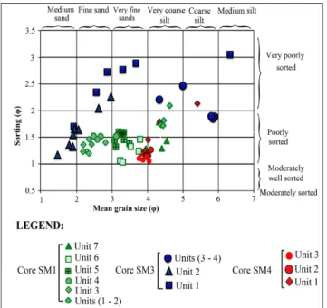
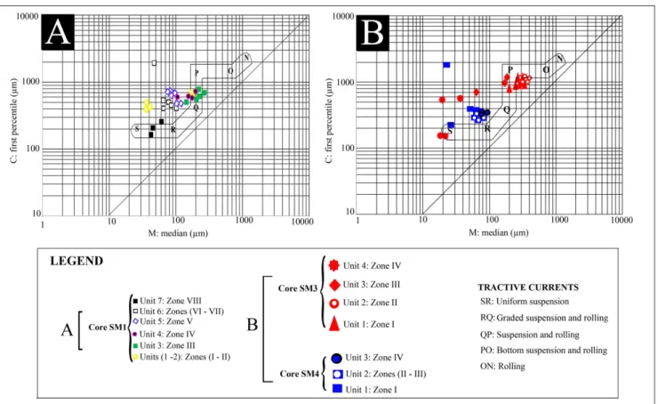
wet sieving using a sieve of 1000 µm to separate the coarser fraction from the fine one (<1000 µm). The fine fraction was then analyzed using a Mal-vern Mastersizer 3000 Laser Particle Analyzer. The grain-size distribution of samples was then aver-aged. Mean grain-size (Mz), sorting or standard de-viation (SD) and skewness (Sk) were calculated ge-ometrically (in µm) and logarithmically (using the φ scale) according to Folk & Ward (1957). The grain-size parameters described in the following sections are commonly used to characterize sedimentary environments and evaluate transport processes and deposition mechanisms and differentiate various modes of fluvial and marine transports (Passega 1957, 1964; Ramanathan et al. 2009; Rajganapathi et al. 2013; Warrier et al. 2016).
Micropalaeontological preparation, taxonomical identification and calculation of biocenotic parameters and
diversity indices. The collected samples were dried at
40°C and their dry weight was determined. Next, they were washed over 63 and 125 μm meshes. From each sample, specimens were picked from the 125 μm fraction and observed under a binoc-ular microscope at 20 to 40 times magnification and foraminifera and ostracods were identified. All specimens of microfauna, contained in one aliquot, were hand-picked using a wet brush. If less than 300 specimens were present per aliquot, the second aliquot was picked. This number guarantees a rep-resentative population for the high diversity assem-blages. The average weight of the samples being 5 grams, the values obtained were reported to 1 gram of dry sediment. We consider only the taxa with a minimum of occurrence of 5% for ostracods and 10% for foraminifera taxa for the differents cores. Also, the allochtonous ostracods are recognized on the base of population structure revealed by the ratio between juvenile and adult individuals (Lapri-da 2001). The taxonomical ostracod identification keys were provided by Bonaduce et al. (1975), Lla-no (1981), Carbonel (1982), Athersuch et al. (1989) and Zaïbi et al. (2016) and by Jorissen (1988) and Cimerman & Langer (1991) for foraminifera (Tab. 1). The identified assemblages (ostracods and
ben-ness (NS), Shannon Index (H) (Shannon & Weav-er 1949), Equitability index (E) (Pielou 1966) and Dominance (D).
Preparation of samples for geochemical analysis. Each sample was crushed until reaching a very fine fraction of the order of a few micrometers. The obtained powder was packed in a capsule and cov-ered by a plastic membrane. Geochemical analysis was performed on powder by means of a Niton FXL, X-ray fluorescence (XRF) analyzer by Ther-mo Scientific to identify the concentration of sev-en elemsev-ents. Geochemical characteristics such as the concentration values of the marine elements Ca, Cl and Sr (Judd et al. 2017) and the terrigenous elements Fe, Al, SiO2 and K (Chagué- Goff et al.
2002), normalized to Al element (Martinez-Ruiz et al. 2015), can be correlated with the sediment source. Engel et al. (2016) noted that the peaks in dissolved salts (Ca, Cl, S) may indicate marine flooding but provide no evidence for the deposi-tional process; however, increases in terrestrial ions (Fe, K) may be used to trace the continental influ-ence.
Radiocarbon preparations and calibration. Five
ra-diocarbon datings on Mollusc shells were consid-ered to determine control ages for lithological units. The 14C datings were carried out at the Mesure du C14 (ARTEMIS) Saclay (France) and at the Iso-topic and Palaeoclimatology (National School of Engineers, Sfax, Tunisia) laboratories. All samples were prepared following a standard procedure (Dé-librias 1985): shells were mechanically cleaned by adding contaminants and leached with dilute HCl to remove portions of shell matrix that might have been affected by exchange reactions and recrys-tallisations (Vita-Finzi & Roberts 1984). Depend-ing on the δ13C values, each sample was calibrated using MARINE13 calibration curves (Reimer et al. 2013) and the CALIB radiocarbon calibration software (version 7.1.0); (Stuiver & Reimer 1993), with a marine reservoir effect of 390±85 yrs and ΔR=35±70 yrs (Siani et al. 2000) for the modern period and Siani et al. (2001) for the last 6000 yr in the Mediterranean Sea. The ages discussed below
are expressed as the total interval age of the 2 σ calibrated range.
Multivariate data analysis
The abundance of ostracods and foraminif-era species was treated in an R-mode cluster analy-sis, performed using paired group algorithm and the Bray-Curtis similarity on the raw data of major spe-cies > 5% for ostracods and > 10% for foraminif-era. We used the results of the cluster analysis to identify assemblages, provide ecological remarks and adopt the results to perform the paleoecolog-ical interpretation. To verify the results of the de-scriptive study and diversity indices, a Correspond-ence Analysis (CA) was realized based on ostracods
and foraminifera absolute abundance and species number and density values (as a supplementary var-iables) by means of Past Software. The core SM1 was herein selected for the multivariate data analysis because it outperformed the other sample cores in thickness (about 3 meters) and richness in micro-fauna and dated levels.
r
esultsSedimentology and macrofauna
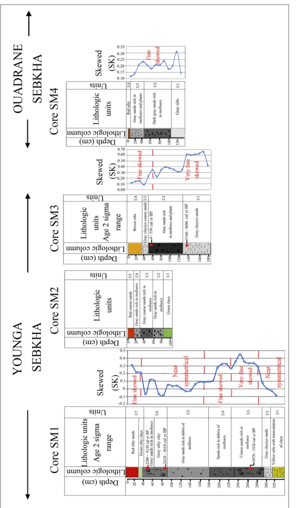
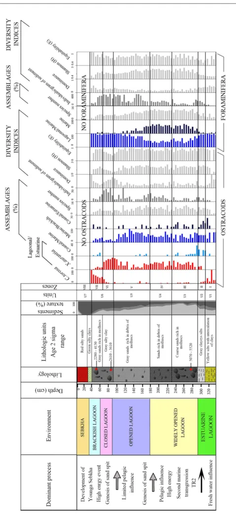
Core SM 1. The core SM1, 330 cm long,
con-sists of seven lithological units (Fig. 2) showing dif-ferent mean grain sizes, standard deviations (Fig.
FORAMINIFERA OSTRACODS
Adelosina longirostra (d'Orbigny, 1826) Aurila convexa (Baird, 1850)
Ammonia beccarii (Linné, 1758) Aurila prasina (Barbeito-Gonzalez, 1971) Ammonia parkinsoniana (d'Orbigny, 1839) Aurila sp.
Ammonia sp. Aurila woodwardii (Brady, 1868)
Ammonia tepida (Cushman, 1926) Basselerites berchoni (Brady, 1869) Cribroelphidium incertum (Williamson, 1858) Carinocythereis carinata (Roemer, 1838) Elphidium aculeatum (d'Orbigny, 1846) Cushmanidea elongata (Brady, 1868) Elphidium advenum (Cushman, 1922) Cyprideis torosa (Jones, 1850) Elphidium crispum (Linnaeus, 1758) Cytheretta adriatica (Ruggieri, 1952) Elphidium macellum (Silvestry, 1900) Cytheromorpha fuscata (Brady, 1869) Elphidium simplex (Cushman, 1933) Hiltermannicythere emaciata (Brady, 1867)
Haynesina sp. Leptocythere fabaeformis (Mueller, 1894)
Masselina secans (d'Orbigny, 1839) Leptocythere pellucida (Baird, 1850) Quinqueloculina agglutinans (d'Orbigny, 1839) Leptocythere sp.
Quinqueloculina annectens (d'Orbigny, 1839) Loxoconcha elliptica (Brady, 1868) Quinqueloculina laevigata (d'Orbigny, 1839) Loxoconcha rhomboidea (Fischer, 1855) Quinqueloculina lamarckiana (d'Orbigny, 1839) Neocytherideis faveolata (Brady, 1868) Quinqueloculina limbata (d’Orbigny, 1826) Semicytherura incongruens (Mueller, 1894) Quinqueloculina padana (Perconig, 1954) Semicytherura sella (Sars, 1866)
Quinqueloculina parvula (Schlumberger, 1894) Semicytherura videns (Mueller, 1894) Quinqueloculina seminula (Linnaeus, 1758) Urocythereis oblonga (Brady, 1866) Rosalina bradyi (Cushman, 1915) Xestoleberis aurantia (Baird, 1838) Rosalina macropora (Hofker, 1951) Xestoleberis dispar (Mueller, 1894) Rosalina sp.
Siphonaperta agglutinans (d'Orbigny, 1839) Siphonaperta aspera (d’Orbigny, 1826) Siphonaperta irregularis (d’Orbigny, 1878) Spiroloculina tenuiseptata (Brady, 1884) Triloculina tricarinata (d'Orbigny, 1839)
Tab. 1 - List of benthic foraminifera and ostracods species identi-fied in this work.
Fig . 2 - Distributio n of Sk ew ed (SK) size parameters , lithological units , calendar ag e and sediment texture (< 63 µm re presented in blac k, betw een 63 µm and 125 µm re presented µm re presented in light g ra y) of SM1, SM2, SM3 and SM4 cores .
3) and transport process (Fig. 4). The lowest unit (U1), 330-305 cm, is made up by yellow silts with clay intercalations. It shows a mean grain size vary-ing between 4.3 and 4.5 φ and a standard deviation between 1.7 and 1.8 φ indicating a poorly sorted sediment. The values of the first percentile range from 320 to 450 µm and of the median percentile vary from 28 to 45 µm. They indicate a transport by uniform suspension process. The second unit (U2) from 305 to 290 cm corresponds to poorly sort-ed gray clayey silts (1.7<So<2) showing the high energy of the environment, comparable with the previous unit. The transport by uniform suspen-sion is proved by the Passega diagram. The grains of both units (U1 and U2) displayed near symmet-rical distribution (-0.1<Sk<0.1). The interval from 290 to 180 cm (U3 and U4) is made up of sands organized in a fining upward sequence. U3, from 290 to 230 cm, reveals the presence of bivalves and gastropoda associated with lithoclasts in coarse sands. It shows a mean grain size varying between 2.3 and 2.8 φ and a standard deviation between 1.1 and 1.5 φ indicating a poorly sorted sediment. Grain size presents a very fine skewed distribution. The Passega diagram levels of U3 show a mode of transport by suspension and rolling. In U4, from 230 to 180 cm, the grains present a fine skewed distribution, their mean size varies from 2.6 to 3.1 φ and they are characterized by the presence of fine
debris of molluscs in sands. Representative points of this interval show that the mode of sediment transport corresponds to suspension and rolling, as the previous unit, represented by QP segment. The unit U5, from 180 to 95 cm, is characterized by gray sands with mean grain size ranging from 3.2 to 3.8 φ and containing fine mollusk debris. SD is between 1.3-1.5, showing poorly sorted sediment. Grain size presents a near symmetrical distribution (0 <Sk<0.1) and the plots of CM patterns show that the sediments are transported by graded sus-pension no rolling process.
U6, from 95 to 40 cm, corresponds to gray silty clays overlaid by gray sands rich in lagoonal molluscs such as Cerastoderma glaucum and Abra alba and lithoclasts. Mean grain size varies between 3.2 and 3.7 φ and the standard deviation ranges from 1 to 1.4 φ, signifying a poorly-sorted sediment. Grain size presents near symmetrical distribution. The levels of the silty clays (interval between 95 and 60 cm) reveal a process of grain transport by uni-form suspension, while the upper levels, constitut-ed by sands (from 60 to 40 cm), show a transport by graded suspension no rolling (Fig. 4). The unit U7 corresponds to green silty clays overlaid by red silty sands with salt crystals. The grain size varies between 3.8 and 4.5 φ and displays a fine skewed distribution. The silts of this zone are transported by a uniform suspension process.
Core SM2. The core SM2, 104 cm long (Fig.
2), contains five lithological units. The lower unit U1, from 104 to 80 cm, is characterized by green clays. The second unit U2, 80-60 cm, is made up of gray sands rich in lagoonal bivalves such as
Cerasto-derma glaucum and Abra alba and gastropoda
repre-sented by Cerithium vulgatum. From 60 to 25 cm, U3 is formed by coarse sands rich in bivalves and gas-tropoda. The unit U4, 25-15 cm, is characterized by gray sands rich in molluscs.
The last 15 cm (U5) are constituted by red coarse sands.
Core SM3. Four lithological units named U1
to U4 are identified (Fig. 2). U1, from 185 to 135 cm, with a mean grain size varying between 2.5 and 3.8 φ, showing fine to very fine sands and very poorly sorted grains (Fig. 3), presents a very fine skewed distribution. The grains are transported by a suspension and rolling process. Unit U2, from 135 to 45 cm, is made up by poorly sorted gray sands rich in phanerogams. The mean grain size varies
Fig. 3 - Relation between mean grain size and standard deviation
of thesubsurface sediments of the selected SM1, SM3 and
between 1.4 and 2.9 φ. Intact brackish bivalves and gastropoda coupled to a rich lithoclasts and debris of molluscs appear in the upper part of U2 and indi-cate high energy deposit. Grain size parameters and the plots of CM patterns show a bottom suspension and rolling transport (Fig. 4). U3, from 45 to 30 cm, corresponds to a poorly to very poorly sorted gray clayey coarse sands where the mean grain size varies between 4.3 and 5.7 φ. The grains are transported by suspension and rolling. Unit U4, from 30 cm to the surface, is composed by poorly sorted brown silts transported buy uniform suspension.
Core SM4. It reveals the following lithological
units (Fig. 2). U1, from 130 to 105 cm, is character-ized by a gray silt with mean grain size varying be-tween 4.1 and 4.8 φ. Standard deviation is from 1.2 to 2.2. The measure of the dispersion of grain size according to a central value indicates poorly sorted very coarse silts (Fig. 3). Grain size presents a fine skewed distribution. The plotting of CM diagram of the unit U1 levels shows a transport by uniform suspension (Fig. 4). U2, from 105 to 45 cm, is char-acterized by dark gray sands rich in molluscs, with mean grain size ranging from 3.9 to 4.2 φ. Standard deviation is between 1.3 and 1.4 φ, revealing a poor-ly-sorted coarse silts. U3, from 35 cm to the surface,
is made up of gray sands overlaid by red silts. The mean grain size varies from 3.8 to 4 φ. U3 is rich in bivalves and vegetable debris. Standard deviation values, varying from 1.2 and 1.4, indicate a poorly sorted sediment. Grain size presents a fine skewed distribution and the plotting of CM diagram shows a transport by graded suspension and no rolling (Fig. 4).
Dating
Three radiocarbon 14C datings on bivalves and gastropoda were determined for the core SM1. In addition, two 14C datings were obtained for the core SM3 (Tab. 2). The top horizon (45-48 cm) of the core SM1 is a little older than the middle horizon (80-85 cm). This suggests that the upper ten cen-timeters of the unit U6, characterized by uniform coarse-grained sediments, were deposited after a high-energy event. This event ultimately lead to a reworking of sediments and may explain the slight reversal of radiocarbon dates within the top layers of SM1. Our age model is herein built on 14C datings obtained from gastropod and bivalve shells. Howev-er, nearshore coastal sediments are subject to intense processes of sediment dynamics and require a care-ful interpretation of dated sediments.
Micropalaeontology
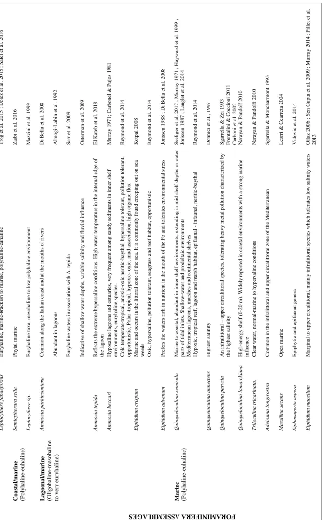
Autoecology of ostracods and benthic foraminifera. Cluster analyses on ostracod and foraminifer taxa were herein used for paleoecological purposes. For each population, only sixteen taxa presented a rel-ative abundance >5% for ostracods and 10% for foraminifera in at least one sample were considered. Cluster analysis in R-mode allowed us to distinguish 16 major species, putting in evidence 3 clusters of taxa (Cl.1 to Cl.3) for ostracods and 2 clusters (Cl.1-Cl2) and 3 single ones for foraminifera, when a cut-off level of 0.18 for ostracods and of 0.40 for fo-raminifera are applied to the clusters. These clusters are regarded herein as biotopes and interpreted as representing ecological conditions (Tab. 3 & Figs I to IV in supplementary material).
Ostracods. The first cluster (Cl.1) corresponds
to the coastal/marine assemblage (Fig. 5a), which encompasses the polyhaline-euhaline Neocytherideis
faveolata, Semicytherura sella and Leptocythere sp. with
a maximal abundance of 13%, 7.5% and 18% be-tween 320 and 280 cm,respectively (Figs 5b and 5c). Cluster 2 (Cl.2), consistent to a lagoonal/estuarine assemblage, includes the typically oligo-mesohaline to very euryhaline Cyprideis torosa and Xestoleberis
au-rantia. It is observed from 280 to 160 cm and
essen-tially from 100 to 35 cm, with height contribution (90%). From 280 cm to 160 cm in depth, C. torosa is almost totally absent while X. aurantia is dominant, reaching 80% (Figs 5b and 5c). However, from 100 cm to 35 cm C. torosa replace progressively X. auran-tia until its complete disappearance. This evolution is characteristic of a closed lagoon evolving to a brackish one under fresh water influence. Cluster 3
(Cl.3), richer in ostracods than the previous, can be subdivided into two sub-clusters (Fig. 5a). Between 320 and 280 cm, Cl.3a, corresponding to a coastal/ estuarine assemblage, contains the polyhaline-eu-haline Aurila convexa (5%) and Aurila sp. and the oligo-mesohaline Cytheromorpha fuscata (20%) (Fig. 5c). In this interval, we also noted the maximal con-tribution of polyhaline-euhaline specie from Cl.1. The mixture between species characterized by dif-ferent ecologic affinities marks a lagoonal environ-ment submitted to freshwater influences. The richer Cl.3b, corresponding to marine/brackish assem-blage, gives a maximal contribution from 160 to 100 cm. It can also be subdivided into two sub-clusters Cl.3b1 and Cl.3b2 (Figs 5a and 5c). The first one, Cl.3b1, contains the polyhaline-euhaline, Loxoconcha
rhomboidea, Semicytherura incongruens, Carinocythereis
car-inata, Hiltermanicythere emaciata, Cushmanidea elongata
and the very euryhaline Loxoconcha elliptica. Cl.3b2 contains the polyhaline-euhaline Leptocythere
fabae-formis and Leptocythere pellucida. The dominance of
the polyhaline-euhaline taxa of cluster 3 indicates a lagoonal environment.
From 280 to 160 cm, the contribution of Cl.3 seems comparable to that of Cl.2. This interval is marked by the presence of the dominant poly-haline-euhaline taxa of Cl.3b1 associated to those of Cl.2 including Xestoleberis aurantia and by the complete disappearance of the euryhaline C. torosa and the reduction of L. elliptica. This interval signs a lagoonal environment opened to the sea with re-stricted fresh water influences.
Foraminifera. The first cluster (Cl.1)
corre-sponding to a marine assemblage can be
subdivid-Cores Depth
(cm)
Studied material Age 14C
a BP Range 1 sigma (68.3%) cal a BP Range 2 sigma (95.4%) cal a BP Median age a cal BP Laboratory SM1 45 – 48 Gastropoda and Bivalvia
3356 ±362 2720 – 3620 2280 – 4130 3170 Isotopic and Palaeoclimatology E.N.I.S. (Sfax, Tunisia) SM1 80 – 85 Gastropoda and
Bivalvia
3297 ±195 2840 - 3330 2610 –3610 3090 Isotopic and Palaeoclimatology E.N.I.S. (Sfax, Tunisia) SM1 261 – 264 Cerithium vulgatum 5015 ±30 5250 – 5440 5070 – 5520 5330 Mesure du C14 (ARTEMIS) Saclay
France SM3 50 –60 Gastropoda and
Bivalvia
658 ±192 80 – 425 0 – 550 270 Isotopic and Palaeoclimatology E.N.I.S. (Sfax, Tunisia) SM3 140 – 150 Gastropoda and
Bivalvia
7445 ±359 7545 – 8260 7160 -8680 7890 Isotopic and Palaeoclimatology E.N.I.S. (Sfax, Tunisia)
Tab. 2 - 14C ages obtained for the lithologic units of SM1 and SM3 cores. Age 14C in yr BP, calibrated ages with 1 sigma range and with 2-sigma
ed in two subcluster Cl.1a and Cl.1b (Figs 6a and 6b). The first one contains the polyhaline-euhaline Quinqueloculina seminula, Siphonaperta agglutunans and
Siphonaperta aspera with a relative abundance of
15%, 5% and 10% respectively from 280 to 90 cm. Cluster (Cl.1b) includes the polyhaline-euhaline Quinqueloculina anectens, Adelosina longirostra, Spirolocu-lina tenuiseptata, MassiSpirolocu-lina secans, Siphoneperta
irregula-ris, Triloculina tricarinata (Fig. 6c). This maximal
con-tribution of the species is observed between 280 to 160 cm depths. The exclusive presence of the polyhaline-euhaline species marks a lagoonal envi-ronment submitted to pelagic influences. Cluster 2 corresponding to lagoonal/marine assemblage
contains the oligo-mesohaline to euryhaline spe-cies Ammonia parkinsoniana and Ammonia tepida with high rates of 60% and 30%, respectively, observed between 330 to 280 cm. The high contribution of species from Cl.2 is also observed from 160 to 35 cm. These are the oligo-mesohaline to euryhaline taxa Ammonia beccari and Elphidium advenum with a contribution of 30% and 20%, respectively. These species, present in the two intervals, indicate a la-goon submitted to fresh water influence for the first one and a closed lagoon for the second with minor fresh water impact. Single species are Elphidium cris-pum, E. macellum and Quinqueloculina parvula.
Core zones: In Core SM1, the variation of
os-Fig. 5 - a) R-mode cluster analysis performed on the 16 fossilized major ostracod species (> 5% in at least one) of the 65 investigated samples showing the clusters Cl.1, Cl.2 and Cl.3 and the sub-clusters (Cl.3a, Cl.3b1 and Cl.3b2). b) Cumulative percentages of taxa composing the defined clusters along core SM1. c) Relative abundance of all major species along the core SM1.
Ostracods taxa abbreviations: Xestoleberis aurantia (Xeau), Loxoconcha rhomboidea (Lorh), L. elliptica (Loel), Cyprideis torosa (Cyto), Hiltermannicythere
emaciata (Hiem), Carinocythereis carinata (Caca), Aurila convexa (Auco), Aurila sp. (Asp), Leptocythere fabaeformis (Lefa), L. pellucida (Lepe),
Leptocythere sp. (Le. sp), Cytheromorpha fuscata (Cyfu), Semicytherura incongruens (Sein), S. sella (Sese), Cushmanidea elongata (Cuel), Neocytherideis
As se m b la g e S p eci es Au to ec ol o gy R ef eren ce OST RACOD S ASS EM BL AG E L ag oo n al /e st u ar in e: (Olig o h ali n e-m eso h ali n e to v er y e ur y ha li ne) C ypr ide is t or os a E u ry h al in e a n d e u ry th er m ic, q u ie t w at er , t o le rat e s a st re sse d e n v ir o n me n t P as cu al & C ar b o n el 1 9 9 2 P u n ct u at ed s p eci m en s i n d ic at e o li g o h al in e t o p o ly h al in e cond it ion s C ar bo ne l 19 8 0 C o m m o n i n b rack is h w at er M ont en egr o & P u gl ie se , 1 995 , 19 96 O li g o -m es o h al in e e x ce p ti o n al ly al so p o ly h al in e, p re fe r mu d d y o r san d y su b st ra te s w it h p la n ts . S u rvi ve i n s al ini ti es u p t o 150 g/ l W ag n er 1 9 5 7 ; A sc o li 1 9 6 7 ; N eal e 1 9 8 8 ; L ach en al 1 9 8 9 T o le rat es a w id e r an g e o f s al in it y ( fr o m 1 t o 1 2 0 g /1 ) an d v ar ia b le t em p er at u re an d o x y g en con di ti on s P in t e t al . 2 0 1 2 T y p ical b rac k is h -l ag o o n al s p eci es T ro g e t al . 2 0 1 3 X e st o le be ri s au ra nt ia B rac k is h w at er , re co rd ed i n co as tal s et ti n g s in cl u d in g in te rt id al p o o ls C ar b o n i e t al . 2 0 0 2 B rac k is h l it to ral s p eci es ( o li g o -m es o h al in e e x ce p ti o n al ly al so p o ly h al in e) P re fe r mu d d y o r san d y su b st ra te s w it h p la n ts M az zi n i e t al . 1 9 9 9 V er y eu ry h al in e Do le z e t al . 2 0 1 5 C oas tal /e st u ar in e (P o ly h ali n e- euha li ne ) C y the rom or p h a fus c a ta O li g o ha li ne -m es o ha li ne D o le z e t al . 2 0 1 5 ; C ar bo ne l 1 9 82 O li g o ha li ne -m es o ha li ne t o v er y e ur y h al ine T ip h ai n e e t al 2 0 1 6 A u ri la pr as ina P o ly ha li ne -e uha li ne , li v ing o n fi ne -g ra in ed subs tr ate s, f re q u en tl y w ith P os ido ni a W ag ne r 195 7; L ac he na l 19 8 9 A u ri la co n v exa Ma ri ne -br ac k is h w at er s, a d apt ed to a g it at ed env ir o nm ent s C o lo n iz e t h e m ed io li tt o ral a n d t h e u p p er l im it o f t h e i n fr al it to ral z o n e N ach it e e t al . 2 01 0 M ar ine /br ac k is h (P ol y ha li ne -e uha li ne ) C ar in oc y the re is c ar in at a M ar in e s u b l it to ral s p eci es t y p ical ly l iv in g o n s an d o r si lt . S u b st rat es at d ep th o f 2 -6 0 m A th er su ch e t al . 1 9 8 9 Se m ic yt h e ru ra i nc on gr ue ns P hy ta l m ar in e, po ly ha li ne -e uha li ne S al el e t al . 2 01 6 M ari n e M ar ri n er e t al . 2 0 1 2 L ox oc on c h a e ll ipt ic a P hy ta l env ir o nm ent s -hy dr o dy na m ic c o ndi ti o ns D o m in at es n ear f lu v ial w at er s u p p li er s O h & C ar bo ne l 1 97 8 ; C ar bo ne l an d P uj o s 19 8 1 ; R ui z et a l. 200 0b; S al el et a l. 2 016 T y p ical f o r b ra ck is h e st u ar in e w at er s (sa li n it y b et w ee n 1 0 a n d 2 0 g /l ). P re fer s h ig h er w at er ene rgy c o ndi ti o ns C ar b o n el 1 9 8 2 ; Z aï b i e t al . 2 0 1 2 E st ua ri n e to cl os ed l agoon w it h hi gh ra n ge of s ali ni ty F ren ze l et B o o m er 2 0 0 5 ; L ac h en al 1 9 8 9 ; M azzi n i et a l. 1 9 9 9 S p an s fr o m 0 .5 t o 3 0 g /l v er y e u ry h al in e D o lez 2 0 1 5 H il ter m a n n ic yt h er e em a ci a ta P h y ta l marin e, c o n fi n ed t o s h al lo w er su b l it to ra l mari n e co n d itio n s A th er su ch e t al . 1 9 8 9 L ox oc on c h a rh om b oi d e a P h y ta l marin e , sh allo w m ar in e, p o ly h ali n e-eu h alin e F . R u iz e t al . 2 0 0 6 ; D o lez e t al . 2 0 1 5 L e pt o c y the re pe ll uc ida E st u ar in e sp eci es P as cu al e t al . 2 0 0 2 T ab . 3 (co ntin ues on p. 529) -A utoecolog y summar y of the prominent spe cies of ostracods and benthic foraminifera assemblag es founded along the core SM1 of the Y oung a Sebkha (Hac hic hina coast).
All species and assemblag
es presented in this table are considered according the Cluster analysis dendrog
ram in R-mode
L e pt oc y the re f abae for m is E ur y ha li ne , m ar ine -br ac ki sh to m ar in e, po ly ha li ne -e uh al in e T ro g e t al . 2 0 1 5 ; D o le z e t al . 2 0 1 5 ; S C oas tal /m a ri n e (P ol y ha li ne -e uha li ne ) S e m ic yt h e ru ra sel la P h y ta l marin e Z ai b i e t al . 2 0 1 6 L ep to cyt h er e sp . E u ry h al in e t ax a , m es o ha li ne t o l o w po ly ha li ne e nv ir o nm ent M az zi n i e t al . 1 9 9 9 FO RAMIN IF ER A ASS EM BL AGE S L ag oo n al /m a ri n e (O li g o h ali n e-m eso h ali n e to v er y e ur y ha li ne) A m m o ni a pa rk in so ni ana C o m m o n al o n g t h e I tal ian co as t a n d a t t h e m o u th s o f r iv er s D i B el la e t al . 2 0 0 8 A bun da nt i n la g o o ns A lm o g i-L ab in e t al . 1 9 9 2 E u ry h al in e w at er s in as so ci at io n w it h A . t ep id a S ar r e t al . 2 0 0 9 In d ica ti v e o f s h al lo w w at er d ep th s, v ar iab le s al in it y an d f lu v ia l in flu en ce O st er m an et a l. 2 0 0 9 A m m o ni a te pi da R ef le cts t h e ex tr em e h y p er sa lin e co n d itio n s. H ig h w ate r te m p er at u re in t h e i n ter n al ed g e o f th e la goon E l K at eb e t al . 2 0 1 8 A m m o ni a be cc a ri H y po sa li ne l ag o o ns and e st u ar ie s, v er y f re que nt a m o ng s an dy s edi m ent s in in ne r she lf env ir o nm ent s, e ur y ha li ne s pe ci es . Mur ra y 1 97 1 ; C ar bo ne l & P uj o s 1 9 81 C o ld te m pe ra te -tr o p ic al , an o x ic -o x ic n er iti c-b ay th al , h y p er sa li n e t o le ran t, p o ll u ti o n t o le ran t, op p or tu ni st ic , P o lar -tr o p ical , h y p o x ic - o x ic, m u d as so ci at io n , h ig h or ga ni c fl u x R ey m o n d e t al . 2 0 1 4 E lphi di u m c ri sp u m M ar in e a n d o cc u rs i n t h e l it to ral z o n e o f t h e s ea . I t is c om m on ly f ou n d cr ee p in g out on se a w eed s K ot p al 2 008 O x ic, h y p er sa li n e, p o ll u ti o n t o le ran t, se ag ras s an d r ee f ha bi ta t, o ppo rt un is ti c R ey m o n d e t al . 2 0 1 4 E lphi di u m ad ve nu m P ref er s th e w at er s ri ch i n n u tr ien t in t h e m o u th o f t h e P o and t ol er at es e n vi ron m en ta l st re ss Jo ri ss en 1 9 8 8 ; D i B el la e t al . 2 0 0 8 M ar ine (P ol y ha li ne -e uha li ne ) Q ui nq ue loc ul in a se m inu la Ma ri ne t o c o as ta l, a b un da nt i n in ne r she lf e nv ir o nm en ts , e x te n di ng i n m id she lf de pt hs o r o u te r p ar ts o f t id al i n le ts . S h al lo w -w at er an d p ro d el tai c en vi ron m ent s Me di te rr ane an l ag o o ns , m ar she s and c o nt ine n ta l she lv es S eel ig er e t al . 2 0 1 7 ; M u rr ay 1 9 7 1 ; H Jo ri ss en 1 9 8 7 ; L an g le t e t al . 2 0 1 4 H y p o x ic, t ro p ical r ee f, l ag o o n an d m ar sh h ab it at , e p if au n al i n fa u n al , n er it ic -b ay th al R ey m o n d e t al . 2 0 1 4 Q ui nq ue loc ul in a a nn e ct ens H ig h est sal in it y D o n n ici e t al ., 1 9 9 7 Q ui nq ue loc ul in a p ar vul a A n i n fr ali tt o ra l – u p p er ci rc al it to ral s p eci es , to le rat in g h eav y m et al p o ll u ti o n ch ar ac te ri ze d b y the hi g he st s al ini ty S g ar re lla & Z ei 1 9 9 3 F ron ta li n i & C oc ci o n i 20 11 C ar b o n i e t al . 2 0 0 2 Q ui nq ue loc ul in a l am ar ck ia na H ig h -e n erg y s h el f (0 -2 0 m ). Wi d el y r ep o rt ed i n co as tal e n v ir o n m en ts w it h a s tr o n g m ar in e inf lue n ce N ar ay an & P an d o lf 2 0 1 0 T ri loc ul in a tr ic ar ina ta , C le ar w at er , n o rm al -ma ri ne t o hy pe rs al ine c o nd it io ns N ar ay an & P an d o lf i 2 0 1 0 A d el os in a lo ngi ro st ra C o m m o n i n t h e i n fr al it to ral an d u p p er ci rc al it to ral zo n e o f th e M ed it er ra n ean S ga rr el la & M on cha rm o n t 199 3 M a ss il ina s e can s O pe n m ar ine L eo rr i & C ear re ta 2 0 0 4 Si ph o na p e rt a as p e ra E p ip h y ti c a n d ep if au n al g en er a V id ovi c et a l. 20 14 E lp h id ium m ac e ll um M ar g in al t o u p p er c ir cal it to ral , m ai n ly i n fr al it to ral s p ec ie s w h ic h to le ra te s lo w s al in ity w ate rs O fl az 2 0 06 ; S en G up ta e t al . 200 9 ; 2 013 T ab . 3 -A utoecolo g y summ ar y of the prominent species of
ostracods and benthic
foraminifera assemblag es founded along the core SM1 of the Y oung a Sebkha (Hac hic hina coast). semblag
es presented in this table are considered according the Cluster analysis dendrog
ram in R-mode
tracod and benthic foraminifera taxa, coupled to their species richness and relative abundances along SM1 core allowed us to distinguish the following zones (Fig. 7): Zone I, from 330 to 310 cm, is char-acterized by the dominance of the lagoonal/estua-rine ostracod association (40%) coupled to malagoonal/estua-rine/ brackish taxa (50%) and coastal estuarine species (10%) in coarse silts. It shows the presence of the euryhaline species C. torosa, L. elliptica, the taxa typ-ical of estuarine environment showing high water energy (Carbonel, 1982; Ruiz et al. 1996) and the oligo-mesohaline C. fuscata (Pascual & Carbonel 1992). The foraminifera reveal the dominance of the lagoonal/marine association (95%) containing the estuarine taxa A. parkinsoniana and A. tepida. Zone II, from 310 to 290 cm, records the first
ap-pearance of macrofauna and the diversification of ostracods and foraminifera. It reveals the appear-ance of the coastal/marine association (15%) con-stituted by the polyhaline-euhaline Semicytherura sella,
Neocytherideis faveolata and Leptocythere sp. coupled to
the marine/brackish association (60%) constituted by L. elliptica, more frequent than in the previous zone and the two phytal polyhaline-euhaline
Lox-ochoncha rhomboidea and Semicytherura incongruens. It
reveals the depletion of the lagoonal estuarine as-sociation (10%), where X. aurantia substitutes C.
torosa, and coastal/estuarine taxa (15%) such as the
estuarine Cytheromorpha fuscata and Aurila convexa. It shows the dominance and persistence of the la-goonal/marine foraminifera (95%) constituted by
A. parkinsoniana and A. tepida associated to the most
Fig. 6 - a) R-mode cluster analysis performed on the 16 fossilized major foraminifera species (> 10% in at least one) of the 65 investigated samples showing the clusters Cl.1, Cl.2 and the sub-clusters Cl.1a, Cl.1b. b) Cumulative percentages of taxa composing the defined clusters along core SM1. c) Relative abundance of all major species along core SM1.
Foraminifer taxa abbreviations: Ammonia parkinsoniana (Apa), A. tepida (Ate), A. beccari (Abe), Elphidium crispum (Ecr), E. advenum (Ead), E.
ma-cellum (Ema), Quinqueloculina parvula (Qpa), Q. annectens (Qan), Q. seminula (Qse), Siphonaperta irrigularis (Sir), S. agglutunans (Sag), S. aspera
(Sas), Spiroloculina tenuiseptata (Ste), Triloculina tricarinata (Ttr), Massilina secans (Mse), Adelosina longirostra (Alo), individuals number (IND) and species number (SPN).
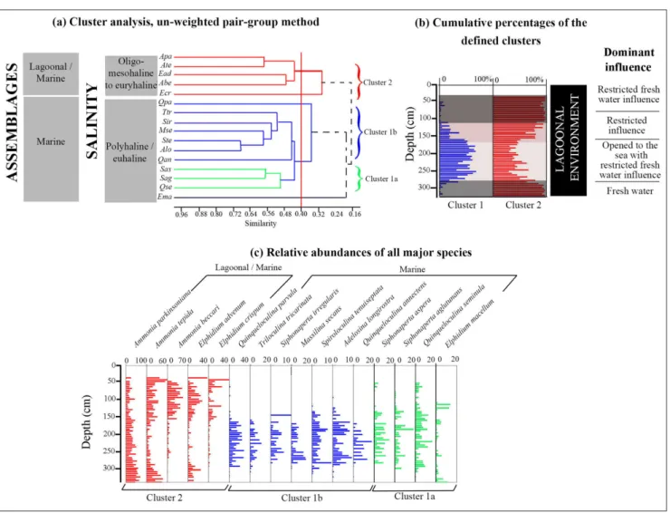
Fig . 7 - Sedimentologic and microfaunistic (ostracods and benthic foraminifera) data of SM1 core . Dominant process , en vironments , lithological column and units , calendar ag e, ver tical distribution of assemblag es , indi viduals n umber/g ram, species n umber and di versity indices .
reduced values of the indices H and E. This in-terval is also characterized by the increase of the species number and density of ostracods and fo-raminifera. Zone III, from 290 to 230 cm, is rich in gastropods and bivalves 5070-5520 cal yr BP in age. The ostracod associations reveal the enhancement of the lagoonal/estuarine taxa (40%), represented exclusively by the euryhaline X. aurantia, associated to the marine/brackish species (50%) containing the polyhaline-euhaline L. rhomboidea, C. carinata and C. elongata. The coastal/estuarine and coastal/ marine taxa have a similar abundance of 5%. Char-acterized by the improvement of species number, the ostracofauna also show the increase of H and E index values. Zone III is also distinguished by the depletion of the lagoonal/marine foraminifera association (55%) coupled with the remarkable en-richment of marine taxa (45%) represented essen-tially by the appearance of the polyhaline-euhaline
Quinqueloculina parvula, Q. annectens, Q. aspera and
Adelosina longirostra. From the base to the top of
the interval, the foraminifera species number and diversity indices H and E record high values and are associated with the reduction of the density. In Zone IV, from 230 to 180 cm, the ostracofaune is characterized by the disappearance of coastal/ marine taxa and the depletion of coastal/estuarine species associated to the enhancement of marine/ brackish and lagoonal/estuarine associations. The individual number reaches 25 individuals/gram of sediment. The foraminifera shows compara-ble association rates then the zone III with the enrichment of the marine species Quinqueloculina
parvula, Spiroloculina tenuiseptata and Adelosina
longi-rostra and a high value of the individual number
reaching up to 150 individuals/gram of sediment. Zone V, from 180 to 90 cm, differs from the pre-vious zone by the depletion of lagoonal/estuarine and the enrichment of marine/brackish ostracods reaching 60%. The upper part of zone V shows the increase of lagoonal/estuarine ostracods, reach-ing 90%, coupled to the reduction of the marine/ brackish taxa. The zone V is also marked by the reduction of ostracod species richness and of the H and E diversity indices coupled with the high values of individuals number. This interval shows the increase of the lagoonal/marine foraminifera, which reaches up to 100%, the reduction of the species number and the diversity indices H and E and the increase of foraminifera density. Zone VI,
from 90 to 60 cm, 2620-3610 cal yr BP in age, is marked by the enhancement of lagoonal/estuarine ostracod (85%), represented by X. aurantia, the de-pletion of marine/brackish species and a drastic enrichment of ostracods density in its upper limit. This zone reveals the enhancement of the lagoon-al/marine association reaching 95%, containing A.
parkinsoniana, A. tepida and Elphidium crispum. The
foraminifera give a high number of individuals and their species number continues to decrease. Zone VII, from 60 to 40 cm, is made up of sands rich in lagoonal molluscs (2280-4130 cal yr BP in age) and lithoclasts. It records the enhancement of the la-goonal/estuarine ostracods, reaching 100%, which reveals the appearance of the euryhaline C. torosa (substituting gradually X. aurantia) and L. elliptica and the reduction of ostracod diversity and den-sity. The enrichment of the marine/brackish, the recurrence of the coastal/estuarine and coastal marine ostracods and the highest values of den-sity mark the limit between the zones VI and VII. The autochthonous origin of the lagoonal/estua-rine ostracod species is evidenced by the presence of the juvenile and adult forms. However, the ma-rine/brackish and coastal/marine species are char-acterized by either juvenile or adult individuals, in fragments, showing their transport, corresponding thereby to a taphocoenose of high energy. In addi-tion, the molluscs of this interval show a dissolved and corroded surface. The zone VII shows the dominance of lagoonal/marine foraminifera, as in the zone VI, reaching 100% and the decrease of their species and individual numbers. Zone VIII, from 40 cm to the surface, is characterized by the absence of foraminifera, ostracods and molluscs.
Core SM2 (Fig. 8): Zone I, from 105 to 85 cm, is distinguished by the dominance the marine/ brackish association (50%), containing the domi-nant polyhaline-euhaline Loxoconcha rhomboidea and
Semicytherura incongruens, associated to the coastal/
marine taxa (30%), such as Leptocythere sp. and
Se-micytherura sella, and lagoonal/estuarine association
represented by X. aurantia (15%). The species num-ber does not exceeded 10 taxa and is associated with reduced values of density. The foraminifera show the dominance of lagoonal/marine association (95%), revealing the dominant taxa A. beccari and
E. advenum. The lowest values of foraminifera
den-sity and diverden-sity indices H and E mark this interval where the species number varies between 6 and 8.
Fig . 8 - Sedimentologic and microfaunistic (ostracods and benthic foramin ifera) data of SM2 core . Dominant process , en vironments
, lithological column and units
, calendar ag e, sediment ver tical distribution of assemblag es , indi viduals n umber/g ram, species n umber and di versity indices .
Fig . 9 - Se dimentol ogic and microfaunistic (ostracods and benthic foramin ifera) data of SM3 core . Dominant process , en vironments
, lithological column and units
, calendar ag e, sediment texture , zones , ver tical distribution of assemblag es , indi viduals n umber/g ram, species n umber and di versity indices .
sity along the core are also observed in this inter-val. The zone II is also marked by the depletion of the lagoonal/marine foraminifera (75%) and by the highest values of density along the core. Zone III, from 30 cm to the surface, is marked by the development of sands rich in lagoonal molluscs. It reveals the reduction of the density, the species number and the two diversity indices (H and E) of ostracods. It is also distinguished by the dominance of the lagoonal/estuarine ostracods, which reach 100 % in the top of the interval, and the first ap-parition of the euryhaline C. torosa in the core. The enrichment of the lagoonal/marine foraminifera, reaching 90% where the euryhaline species A. tepi-da and A. parkinsoniana are dominant, is coupled to the decrease of species richness and density.
Core SM3 (Fig. 9): Zone I, from 185 to 120 cm, made up by fine clayey sands (U1), 7160-8680 cal yr BP in age, is marked by the dominance of the two assemblages marine/brackish (45%) and lagoonal/estuarine (35%), associated with the coastal/estuarine (10%) and coastal/marine taxa (10%). It reveals important values of species rich-ness and density. The high values of the diversity indices H and E indicate a rich population where the individuals are equitably distributed among species. The lagoonal/marine foraminifera, mainly represented by Ammonia tepida and A. beccari, are dominant (70%). This zone is characterized by high values of species richness and of H and E diversity indices and reduced density values. Zone II, from 120 to 75 cm; shows, from the base to the top, the enhancement of lagoonal/estuarine taxa reaching 80%. This zone is also characterized by the reduction of the species richness and density. The decrease of the H and E indices indicates an unstructured population where the individuals are inequitably distributed among the species. The la-goonal/marine foraminifera reach 90% in the up-per part of the zone associated to the increase of the individual number and the reduction of H and E values. Zone III, from 75 to 30 cm, is represent-ed by sands and clayey sands characterizrepresent-ed by their richness in Posidonia sp., bivalves and gastropods,
goonal /marine taxa as in the zone II. The mid-dle part of the zone, at 60 cm depth, is marked by the abrupt recurrence of the marine/brackish and of coastal/estuarine ostracods associated to the high values of density and ostracods species richness. Different aspects observed through the foraminiferal tests of robust taxa (breaking of the last chambers, abrasion of the external ornamenta-tion) plead for an important transport process. All these parameters mark the recurrence of pelagic influence and reveal a high-energy event towards 0-550 cal yr BP. Zone IV, from 30 cm, is formed by brown clays without fauna.
Core SM4 (Fig. 10): Zone I, from 130 to 95 cm, is made up of gray silts. The dominant ma-rine/brackish ostracod association (60%), contain-ing the estuarine L. elliptica, the polyhaline-euhaline
Leptocythere fabaeformis and Aurila woodwardii, is
as-sociated to lagoonal/estuarine (15%), coastal/es-tuarine (15%) and coastal/marine (10%) taxa. The density and species number of ostracofaune are the most reduced of the core. The zone I records the dominance of the lagoonal/marine foraminifera association reaching 95%, represented essentially by the estuarine taxa A. parkinsoniana, the reduced values of species number and an important den-sity reaching 1500 individuals/gram of sediment. Zone II, from 95 to 60 cm, is built up by fine sands characterized by their richness in molluscs. The lagoonal/estuarine ostracods reach 40% and are associated to the depletion of marine/brack-ish (45%) and coastal/estuarine (5%) taxa. This interval is also marked by the increase of species richness and density. The marine foraminifera taxa, reaching 5%, are represented by Elphidium simplex and Quinqueloculina seminula. However, the density and the species number of foraminifera increases slightly. In Zone III, from 60 to 35 cm, the lagoon-al/estuarine ostracods taxa are further dominant reaching 70% and associated to the depletion of marine/brackish, coastal/marine and coastal/estu-arine taxa. The ostracofauna records a high den-sity and a reduced species number. To the top of the interval, X. aurantia is more reduced and gives
Fig . 10 Sedimento logic and microfaunistic (ostracods and benthic foraminifera) data of SM3 core . Dominant process , en vironments
, lithological column and units
, calendar ag e, sediment texture , zones , ver tical distribution of assemblag es , indi viduals n umber/g ram, species n umber and di versity indices .
(U3) and records the enrichment of the euryhaline C. torosa, reaching 80%, coupled with the depletion of the marine/brackish taxa (10%) and the dis-appearance of the coastal marine species and the decrease of ostracods species number and density. It records the enhancement of lagoonal/marine (55%) and the depletion of marine taxa to the top (45%). A punctual increase of the marine/brack-ish ostracods and marine foraminifera, a high value of species number and density of the ostracofauna and foraminifera mark the middle part of the zone IV. In addition, the molluscs have abraded shells and disarticulated valves associated to dissolved and corroded foraminifera tests. All these parame-ters corroborate a high energy deposit.
d
IscussIonPalaeoenvironmental reconstruction
Through the results of palaeontological, sed-imentological and geochronological analyses, we could reconstruct the changing palaeoenvirone-ment within the investigated Hachichina wetland and compare this evolution with Mediterranean coast. In the following section, the evolution of the investigated area is discussed in three levels: i) The early Holocene pre-transgressional bedrock; ii) Sea-level rise and genesis of the sand spit; and iii) phase of sand spit genesis and high energy event.
The early Holocene pre-transgressional bedrock.
In-vestigations of Morzadek (2002) showed the estab-lishment, in the West of the Gulf of Gabes, of seb-khas at the isobaths -25, -28 m, between 28.340 and 21.120 cal yr BP, a marine environment at -75 m, around 12.580 cal yr BP and a transgression which invaded the gulf of Gabes from 9.930 cal yr BP. For Goy et al. (1996), the deceleration of relative sea-level rise took place in the Mediterranean coast at 10.000 cal yr BP. Lambeck et al. (2014) note a de-crease in the rate of sea level rise from 8.2 kyr to 2.5 kyr BP, after which ocean volumes remained nearly constant until the renewed sea-level rise at 100-150 yr ago, with no evidence of oscillations exceeding
2009). In the Sebkhas Younga and Ouadrane, by means of the different cores, two old subsurface sediments reached are Middle Holocene in age (Fig. 11). The first one relates to the unit U1 (SM3 core), corresponding to clayey sands > 7160-8680 cal yr BP in age. The second one corresponds to the unit U1 (SM1 core) made up by yellow sands with inter-calations of clays > 5070-5520 cal yr BP in age.
Sea-level rise and genesis of the sand spit. The first
marine transgression (TR1) took place towards 7160-8680 cal yr BP. It is limited in the southern part of Younga Sebkha and recorded at SM3 core (zone I, unit U1) by the widely opened lagoon en-vironment, with the dominance of lagoonal/ma-rine foraminifera (70%) and high values of species richness and diversity indices H and E (Figs 11 and 12). The opening of the environment to the sea is also proved by the ostracofauna revealing the dom-inance of the lagoonal/estuarine (35%) associated to marine/brackish (45%) taxa and high values of species number, density and diversity indices H and E. The high energy is revealed by the very poorly sorted grains transported by suspension and roll-ing process. Under a context of risroll-ing sea level, and at Skhira Southern coast, studied by our team and published by Zaibi et al. (2016), the continental Holocene sands and clays were overlaid by a widely opened lagoon biofacies rich in marine ostracods and foraminifera recording a transgressive event to-wards 7460 cal yr BP. For the same period, Lakhdar et al. (2006) describe, in Boujmel Sebkha, marine sands 7445 cal yr BP in age. This first marine flood-ing, TR1, coherent with delta initiation recorded throughout the circum Mediterranean (Stanley & Warne 1994; Anthony 2009), is also recognized be-tween 8.7-7.5 cal kyr BP in the Spanish coast (Mar-co-Barba et al. 2013). A period of wetter conditions was registered in the Sahara and Sahel, from 9.5 to 7.0 cal kyr BP (Damnati 2000) and the genesis of freshwater carbonate structures in the hyper-arid Gebel Uweinat (Egypt), between 9.4 and 8.1 cal kyr BP, is mentioned by Margarita et al. (2014). In Northern Spain coast, modern estuaries began to develop around 8.5 cal kyr BP (Leorri &
Cearre-ta 2004). In Central Tunisia, the improvement of environmental conditions were detected, such as in Maknassy from 10 to 7 cal kyr BP (Ouda et al. 1998), in Kasserine area from 7.5 to 7.2 cal kyr BP (Zarai 2006), in Jebel Goubrar-Khechem (Amami 2010) from 8.0 to 7.5 cal kyr ? BP and in Gafsa area, from 8.790 to 3.230 cal kyr BP in age (Henchi-ri 2014).
The second marine transgression (TR2) 5070-5520 cal yr BP in age. TR2 is recorded in the cores SM1 (zone III, unit 3), SM2 (zone I, unit 1), SM3 (lower part of zone II, unit 2) and probably SM4 (zone I, unit 2) (Figs 11 and 12). More impor-tant than TR1, it allows the settlement of a widely opened lagoon, which covers the two sebkhas. TR2 is marked, in SM1 core, by a large size of quartz grains, poorly sorted sands rich in molluscs, the dominance of lagoonal/estuarine ostracods (40%) and marine/brackish taxa (50%) and the increase of species number. The enrichment of the marine foraminifera, the high values of the species number and of the diversity indices mark the importance of the pelagic influences and the opening of the environment to the sea. The suspension and rolling process grains transport indicates the high energy. The installation of this widely opened lagoon envi-ronment follows an estuarine background (zone I, SM1 core and zone I, SM4 core). The latter reveals a ponding of freshwater runoff from the hinter-land plain behind Younga and Ouadrane Lagoons to produce the brackish water conditions. This en-vironment allowed the dominance of the euryhaline taxa L. elliptica, typical of estuarine environment and high water energy associated to the estuarine foraminifera A. parkinsoniana (60 %), which reflects the impact of the Ouadrane and Younga water-courses and the dilution of marine waters.
Around 5500 cal yr BP, El Melah Sebkha (South of Gulf of Gabes) was invaded by a sea whose level was 2 m higher than the current one and marked by shell accumulations (Perthuisot 1975). For the same period, Zaibi et al. (2011) describe a closed lagoon at Southern Skhira coast, which re-cords a step of opening towards 5408 cal yr BP syn-chronous with the transgressive event TR2, report-ed herein at the Younga Sebkha. Jreport-edoui et al. (1998) report, on Jerba coast, bioclastic deposits covering the range 5900-4000 yr BP, located at altitudes var-ying between +40 and +100 cm, as well as marine deposits, 2100 yrs BP in age, positioned at the same
level of the sea. The regularity of the marine depos-its, having the same age, with respect to the sea level confirms for these authors the absence of tecton-ics. They conclude that the elevation, realized be-tween 5900 years BP and 2000 years BP, would have a hydro-isostatic origin. However, for Morhange and Pirazzoli (2005), the emersion of Jerba coastal fringe would have reached a higher altitude of 186 cm and would be produced from 6000 years and stopped around 5000 years ago. However Vacchi et al. (2015) note that in the western Mediterranean, RSL rose continuously for the whole Holocene with a sudden slowdown at 7.5 kyr BP and a further de-celeration during the last 4 kyr BP; after which time, observed RSL changes are mainly related to varia-bility in isostatic adjustment. The sole exception is southern Tunisia, where data show evidence of a mid-Holocene high-stand compatible with the iso-static impacts of the melting history of the remote Antarctic ice sheet. On the other hand, Bedir et al. (1995) and Ghribi (2010), based on a seismological study, identified several active faults, directed N120, which affected Hachichina wetlands, delimit Ouad-rane valley and continue in MediterOuad-ranean Sea. They note the importance of the neotectonic in Skhira area. Thereby, the second transgression event (TR2) can be attributed to the subsidence of the basement Skhira coast, a behavior favored by the reactivation of these faults.
Phase of sand spit genesis and high-energy event. The evolution of the widely opened lagoons to the present sebkha, by passing successively through an opened lagoon, a closed lagoon and a brackish la-goon can be explained by the genesis of sandy spits. This evolution is proved by the decrease of species richness, the enhancement of lagoonal/estuarine ostracod and lagoonal/marine foraminifera and the improvement of the densities (Fig.12). Also, the subsurface sediments show significant changes in element ratios profiles, influenced, in particular, by a substantial variations in the values of fluvial input proxies (K/Al) and of the terrigenous Fe/ Al ratio (Fig. 13). Ouadrane Wadi discharge, dur-ing the estuarine lagoon period, would have mainly contributed clays from source regions, rich in il-lite and chlorite, leading to these increasing ratios. The reduced ratios of marine elements, Sr/Al and Cl/Al, during this period sign an estuarine lagoon submitted to fresh water influences and the dom-inance of brackish waters, as it is indicate by the