PhD Programme in Analysis and Governance of Sustainable Development Ca’ Foscari University of Venice, IUAV University in Venice, and
School for Advanced Studies in Venice Foundation 23rd cycle
A.A. 2007/2008- A.A. 2009/2010
GROUNDWATER IN URBAN COASTAL AREAS:
HYDROGEOCHEMICAL BASED APPROACH FOR MANAGING THE TRANSITION AREAS.
The example of the lagoon of Nador (Morocco).
PhD Candidate: Viviana Re 955409
SCIENTIFIC AREAS: GEO/05 GEOLOGIA APPLICATA
GEO/08 GEOCHIMICA E VULCANOLOGIA
Programme coordinator: Advisor:
Prof. Giovanni Maria Zuppi Prof. Giovanni Maria Zuppi Co-Advisors:
Dr. Alice Aureli
Dr. Andrea Merla
… … …
…w w we made from water every living thing. w e made from water every living thing. e made from water every living thing. e made from water every living thing.
[Al [Al
[Al [Al----Qur'aan 21:3 Qur'aan 21:3 Qur'aan 21:3 Qur'aan 21:30] 0] 0] 0]
Printed on recycled paper
Index
Abstract V
Riassunto VII
Acknowledgments IX
Part one: PROBLEMATICS AND RESEARCH OUTLINES
Introduction
3I. Towards a holistic approach and the need for integration: Integrated Water Resources Management (IWRM) and Integrated Coastal Zone Management (ICZM) 3
I.I. Integrated Water Resource Management (IWRM) 4
I.II Integrated Coastal Zone Management (ICZM) 5
I.III Integrated Coastal Area and River Basin Management (ICARM) 6
II. The Mediterranean Basin 7
II.I. The Middle East and North Africa (MENA) region 10
III. The African shore and its lagoons 12
Strategic Partnership for the Mediterranean Sea Large Marine Ecosystem
15Research outlines and strategies
19Part two 1. The study area: the lagoon of Nador and the Bou-Areg coastal aquifer
231.1. Physical geography 23
1.1.1. Morphology 24
1.1.2. Hydroclimatology 25
1.2. Geological settings 26
1.3. Hydrological settings 29
1.3.1. Terrestrial inputs 29
1.3.2. Marine inputs 32
1.4. Hydrogeological settings 32
1.5. Human geography 35
2. The study area: literature review
392.1. Previous projects 41
3. Materials and Methods
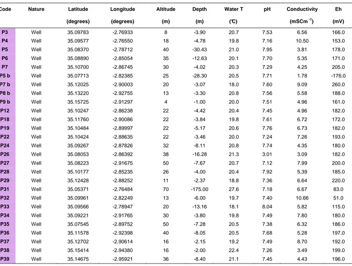
433.1. Water sampling and instrumentation 44
3.1.1. Groundwater sampling 46
3.1.2. Lagoon water sampling 48
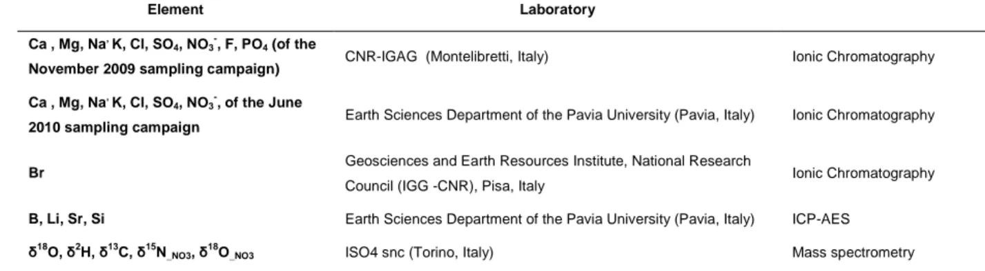
3.2. Analytical methods 48
3.2.2 General chemistry and trace elements 49
3.2.2. Environmental isotopes 49
3.3. Data Treatment 50
3.3.1. Hydrochemistry 50
3.3.2. Principal Component Analysis 52
3.3.3. Clustering Analysis 53
3.3.4. Thematic Cartography 53
4. Results
554.1. Preliminary campaign: November 2009 55
4.1.1. The Bou-Areg Aquifer 55
4.2. Spring campaign: June 2010
57
4.2.1. The Bou-Areg Aquifer 57
4.2.2. The Lagoon of Nador 57
4.3. Fall campaign: November 2010 55
4.3.1. The Bou-Areg Aquifer and oued Selouane 55
5. Discussion: the Bou-Areg Aquifer
675.1. Groundwater classification 67
5.2. Tracing groundwater recharge 68
5.3. The origin of groundwater salinity 73
5.4. Evaluation of human induced pollution: Nitrates in groundwater 83
6. Discussion: the Lagoon of Nador
896.1. Water classification 89
6.2. Geochemical Processes 92
7. Preliminary results of the November 2010 campaign 101
8. Statistical analysis
1058.1. Principal Component Analysis 105
8.2. ClusteringAnalysis 113
9. Conclusions and future perspectives
117References
123ANNEXES
135ANNEX 1: Geological map of the Bou-Areg coastal plain
137ANNEX 2: Environmental isotope in hydrogeology
139Abstract
The urgent need for integrated approaches to water resources management in coastal regions implies performing studies on the relations between the drainage basin (catchment area) and the aquifer throughout the near coastal zone, and to develop adequate science based policies oriented to achieve sustainability goals. The Mediterranean basin is a good example of such needs, since a strong public and scientific effort promoted the application of a holistic approach for achieving the sustainable exploitation of water resources and the adoption of best management practices. This area has been object of several studies and conventions; however, discrepancies, still exist between the European rim countries and the Middle East and North Africa (MENA) region ones, especially related to environmental protection.
Moreover, even for areas where increasing attention is paid to coastal environments, transition zones, and lagoon system protection, so far most of the interest was focused on the ecological functions of these areas and the possible development for aquaculture activities.
Based on these premises, the Strategic Action Plan for Large Marine Ecosystems, the first project bringing together some of the main partners working in the Mediterranean for joint implementation of actions, was created with the goal of protecting the natural Mediterranean environment and to improve the quality of the life in rim countries. Within this framework, the lagoon of Nador (Morocco) represents the pilot case study for the UNESCO IHP sub component (Management of Coastal Aquifers and Groundwater).
The investigation on the Bou-Areg aquifer and the lagoon of Nador was therefore aimed at (i) applying hydrogeochemical tools for supporting coastal aquifers management, with a specific focus on urban coastal areas in semi-arid climates, and (ii) at unravelling the role of groundwater in sustaining coastal lagoons and wetlands, including their habitats and ecosystems, around the Mediterranean shores, concentrating on the Nador Lagoon in Morocco.
The geochemical and isotopic (δ2H, δ18O, δ13C, δ15NNO3, δ18ONO3) characterization of the Bou Areg aquifer based on samples collected during two surveys in November 2009 and June 2010, allowed for the identification of runoff from the mountain regions and agricultural return flows as the main sources of aquifer recharge. The high salinization of the aquifer is not only due to the intensive agricultural activities but it is also associated to the natural characteristics of the catchment. The isotopic signal of dissolved nitrates allowed for the identification of two main sources of nitrogen in the system: (i) fertilizers and (ii) manure and septic effluent. The multivariate statistical analysis supported the geochemical evidences and confirmed the need for deeper investigation on the irrigation channel and rivers network in order to identify adequate end members for mixing processes studies.
Riassunto
Gli approcci integrati per la gestione di zone costiere richiedono una approfondita conoscenza delle relazioni tra acque superficiali, sotterranee e la zona litorale circostante, poiché gli obiettivi di sostenibilità possono essere raggiunti soltanto attraverso politiche basate su adeguati dati scientifici.
Il bacino del Mediterraneo è un buon esempio del tentativo di applicare un approccio olistico alla gestione delle risorse idriche. Sebbene tale area sia da molti anni oggetto di svariati progetti e convenzioni, il divario esistente tra i paesi Europei e quelli del litorale sud (la cosiddetta regione MENA) è ancora piuttosto ampio, soprattutto per quanto riguarda la protezione ambientale. Inoltre, a scala di bacino, anche laddove siano presenti studi di gestione di ambienti costieri, zone di transizione e lagune, che rappresentano le risorse più fragili, l’attenzione è quasi sempre focalizzata sulle loro funzioni ecologiche ed il loro possibile utilizzo per fini commerciali (in particolare pesca ed acquacoltura).
Sulla base di queste premesse è stata creata la Strategic Action Plan for Large Marine Ecosystem, (Partenariato strategico per i grandi ecosistemi marini) che rappresenta il primo progetto a cui afferiscono tutti i principali attori che lavorano nel Mediterraneo, con l’obiettivo di preservarne il suo ambiente naturale ed allo stesso tempo, migliorare la qualità della vita nei paesi che su di esso si affacciano.
Nell’ambito del progetto SAP MED, la laguna di Nador è stata scelta per rappresentare il caso di studio del Marocco per la sottocomponente gestita da UNESCO-IHP. L’analisi dell’acquifero di Bou-Areg e della laguna di Nador ha due obiettivi principali: (i) applicare strumenti di analisi idrogeochimici a supporto dei progetti di gestione degli acquiferi costieri e (ii) chiarire lo stato di qualità delle acque sotterranee ed il loro impatto sulla qualità delle acque lagunari.
L’analisi geochimica ed isotopica (δ2H, δ18O, δ13C, δ15NNO3, δ18ONO3) dei dati raccolti durante due campagne (Novembre 2009 e Giugno 2010) ha permesso di identificare le acque di ruscellamento ed i flussi di ritorno dall'attività agricola come le due principali fonti di ricarica dell’acquifero. L’elevata urbanizzazione e le attività agricole rappresentano invece le principali cause di alterazione della normale salinità dell’acquifero. Lo studio idrochimico, supportato dall’analisi statistica multivariata, non ha evidenziato presenza di processi di intrusione salina dalla laguna verso l’acquifero.
L’analisi isotopica dei nitrati disciolti ha infine permesso di individuare due principali fonti di azoto nelle acque sotterranee: (i) fertilizzanti sintetici e (ii) effluenti di fosse settiche e letame.
I dati ottenuti in questo studio, opportunamente integrati con quelli ottenuti nelle due campagne successive previste dall’intero progetto, verranno presentati alle autorità competenti del Marocco ed utilizzati a supporto di adeguate politiche di gestione delle risorse idriche nella regione di Nador.
Acknowledgments
My sincere thank goes to Prof. Gian Maria Zuppi, who made possible this work to be performed and who guided me during the whole project.
I would like to express my gratitude to UNESCO-IHP, which partially financed this study together with the Italian Ministry for the Environment, for the great opportunity they gave me to work in the frame of the SAP-MED programme. Moreover, my thank goes to Dr. Alice Aureli, Mr. Francesco Rizzo, Dr. Andrea Merla, Dr. José Luis Martin-Bordes and Mr. Holger Treidel for the kind support they gave me since the very beginning of this project.
I am grateful to Dr. Youssef Filali Meknassi and Ms. Ghizlane Moulanaychouf of UNESCO-Rabat, for having organized the first meeting in 2009, and for their fundamental support and help during my stays in Morocco.
I thank the University of Oujda, Faculté Pluridisciplinaire of Nador, for the nice welcome, organizational help, and access to the laboratories during the first two sampling campaigns. In particular, I thank Prof. Najib El Hamouti and Mr. Rachid Bouchnan for their contributing work during the two fieldworks of November 2009 and June 2010, and for providing the geological map of the region.
I’m sincerely grateful to Prof. Namira El Amrani, of the University of Settat (Morocco), for the precious help and the nice time spent working together during the November 2010 campaign.
I want to thank the well’s holder in the Nador area, who kindly allowed us to collect the samples, and Mr. Mohammed for having guided us around the plain.
I thank Prof. Gianfranco Ciancetti, and Mr. Gabriele Dolza from the University of Pavia (Italy), Dr. Ilaria Baneschi of Geoscience and Earth Resources-CNR (Pisa, Italy) and Mr. Mauro Brilli of CNR IGAG of Montelibretti (Italy) for the chemical analyses, and Dr. Giorgio Socal of CNR-ISMAR (Venice, Italy) who kindly lent us the phytoplankton sampling net.
I’m grateful to Prof. Mike Edmunds who gave me the possibility of doing a visiting period at the Oxford Centre of Water Resources (Oxford, UK), and for the precious geochemical lessons I’ve learnt from him.
I warmly thank Prof. Josep Mas-Pla and Dr. Anna Menciò of the Department of Environmental Sciences, University of Girona (Spain) for the days spent in their department, the help in performing the last part of this thesis and all their valuable advices. A special acknowledgment also to Eva, Mercè, David, the colleagues of the Grup de Recerca en Geologia Ambiental i Aplicada (GAiA), Anna and the friends in Girona for the nice welcome and stay.
My warmest thanks to Dr. Elisa Sacchi of the University of Pavia (Italy), “my first teacher”, for the advices she always gives me, and for her patient guidance. Thanks to Dr. Enrico Allais, together with the ISO4 s.s. (Turin), for the access to the laboratory, the isotopic analysis and for all the things I’ve learnt from him.
A special thank to Ms. Marni Wood, an excellent secretariat and friend, for the kind help during these three years, and Ms. Lisa Negrello for her assistance during the last DAGO months.
Finally, I would like to thank all my friends for their support during all the ups and downs of this research. In particular, my thanks go to:
the DAGO mates, Simone, Stefania, Helen and Ilaria;
Lucia and Stefano, good friends and researchers, who shared with me so many beautiful moments;
Giusi, Lisa and Elena without whom the last two years would not have been so nice;
Giulia, who is always present despite the distance, as a very good friend and special adviser;
Cindy, Manuela, Paolo, Giovanni, Benedetta, Stefania and all the Oxford gang, who welcomed me to their big family.
Vyron, Alessandro, Carlos, Gioia, Giulia, Rita, Nicoletta, Eloisa, Virginia, Giovanna, Francesca, and all the other people who, with a word, a smile or a glass of wine share their life with me.
Walter and Giuliana, because they have always encouraged me to follow my dreams.
Tomas for the critical review of this work, his suggestions, help and the constant support, in this thesis and in my life.
Note: Special thank to L. Bouchaou and the co-authors of the work: Application of multiple isotopic and geochemical tracers for the investigation of recharge, salinization and residence time of water in the Souss-Massa aquifer, southwest of Morocco. Journal of Hydrology (2008) 352, 267-287. This work was a great inspiration for the structure of chapter 05 and 06.
PART ONE
Introduction
I. Towards a holistic approach and the need for integration: Integrated Water Resources Management (IWRM) and Integrated Coastal Zone Management (ICZM)
Water is a fundamental resource for human development and wellbeing, nevertheless its use for urban, industrial and agricultural needs has severe impacts on the ecological, environmental, social, economical and political spheres.
The above interactions, given the integrated nature of the water cycle, further complexify water resource management.
Therefore, over the years both scientists and politicians acknowledged that an integrated approach is the only way for properly managing water resources.
The necessary integration has to be performed avoiding the study of each component of the water cycle in an isolated way. It has to be applied both at hydrological and ecological levels, i.e. studying the catchment basin in its whole complexity, and considering its impact on fauna and flora. Hence,
“integration” must be translated into a holistic approach, where hydrogeology, social and economical sciences acts in a synergic way, and global/climatic changes are taken into account in water use categories.
Following the uncertainty related to climate changes, population growth (especially in urban areas), and the consequent need to address emerging water scarcity and human induced pollution, the integrated approach is seen to be the only possible way for finding adequate solutions to water issues.
There are several models proposing integrated approach to deal with water sustainability at different levels.
The most used one, an operative framework for achieving sustainability goals, is the so-called Integrated Water Resource Management (IWRM), whose features and evolution over the years are presented in the following section. The focus of the second part of this chapter is than on another specific application of IWRM, the Integrated Coastal Zone Management (ICZM). This approach considers the relevance and vulnerability of coastal systems, another important issue for the proposed research project.
To conclude, a combination of IWRM and ICZM, is presented: the Integrated Coastal Area and River Basin Management (ICARM).
Tackling all the aspects of the above-mentioned approaches is beyond the scope of the manuscript, nevertheless some introductory notes are presented in order to facilitate the reader and introduce the main purposes of the research.
I.I. Integrated Water Resource Management (IWRM)
The concept of Integrated Water Resource Management, that become a mainstream idea after the 1977 United Water Conference in Mar de la Plata (McDonnell, 2008), has been discussed for more than 30 years (Braga, 2001).
Initially the innovation, in the framework of water management, was the inclusion of the term “integration”.
As McDonnell (2008) pointed out, since the very beginning integration meant “to include the natural hydrological environment in engineering and economic driven solutions”. More recently new considerations have been added to the IWRM concept, therefore it is now perceived as a new paradigm that can lead to long term solutions to water problems. From a practical point of view, there is a shift from a top-down (supply-led) approach, towards a more holistic approach, based on local ideas and demand management (McDonnell, 2008).
These evolutions allowed to pass from single purpose projects to multidisciplinary ones (GWP 2003;
Braga and Lotufo, 2008), more coherent with the intrinsic nature of water resources and the features of the planning process.
According to the level chosen for the analysis and implementation, IWRM can be a powerful tool to solve upstream-downstream conflicts (for a river) or transboundary controversies (in particular in cases of shared groundwater resources) considering the whole basin (catchment) scale (GWP, 2009).
In fact, management plans taking into account all the component of a problem are more likely to lead to sustainable water use, although the main problem is related to the concrete implementation of those practices.
Indeed, even if many attempts have been done to put those concepts into practice, not many changes have occurred at global level. During the World Summit on Sustainable Development (WSSD) held in Johannesburg in 2002, the international community made an important step towards more sustainable patterns of water management by including in the Plan of Implementation (POI) as a call for all countries to "develop integrated water resource management and water efficiency plans by 2005“ (Jønch-Clausen, 2004). However, a scarce response so far has been given to key commitment from the national and international governments, possibly for lack of replicable examples.
This is why Molle (2008) defined IWRM as a good example of the so-called Nirvana Concepts, i.e. a
“vision”, an “image of what the world should tend to”.
In order to achieve the IWRM goals, many efforts are required by the involved agents. If the scientists have to avoid performing a pure “conceptual and academic exercise”, the other stakeholders have not to consider it as a “ticked box on the way to securing funding for a project or program” (McDonnell, 2008).
As already mentioned, the ideas of good governance through integrated water resources management are predicated on bringing together our understanding of water from many domains, thus the supply of knowledge and information is an important part of any enabling environment (McDonnell, 2008).
A robust basis for good policy choices (through the incorporation of IWRM in national policies; GWP, 2009) needs adequate information on hydrological, ecological, social and economical characteristics of the catchment area. Once the baseline conditions are defined the focus should than move to the analysis of human impacts (or alteration of the baseline conditions). This will allow the prediction of the responses of the catchment system to factors such as effluent discharges, diffuse pollution, changes in agricultural or other land use practices and the building of water retaining structures (Edmunds and Shand, 2008;
McDonnell, 2008).
I.II. Integrated Coastal Zone Management (ICZM)
Under the need for integration in water management, another holistic approach has been developed over the years: the Integrated Coastal Zone Management (ICZM) aimed to consider all the aspect of a coastal zone, including geographical and political boundaries, in the attempt to achieve sustainability.
This concept was developed for the fist time in 1992 during the Earth Summit of Rio de Janeiro, and the related policy was defined in the chapter 17 of the proceedings of the summit within Agenda 21 (UN, 1992).
From that moment on several scientists and inter-governmental associations proposed their definition of ICZM (Vallega, 2003). Despite some differences, all the definitions have in common the most relevant features and the stress on the holistic approach.
A quite exhaustive definition is the one given by the European Commission (2000):
[ICZM is] a dynamic, multidisciplinary and iterative process to promote sustainable management of coastal zones. It covers the full cycle of information collection, planning (in its broadest sense), decision making, management and monitoring of implementation. ICZM uses the informed participation and cooperation of all stakeholders to assess the societal goals in a given coastal area, and to take actions towards meeting these objectives. ICZM seeks, over the long-term, to balance environmental, economic, social, cultural and recreational objectives, all within the limits set by natural dynamics. 'Integrated' in ICZM refers to the integration of objectives and also to the integration of the many instruments needed to meet these objectives. It means integration of all relevant policy areas, sectors, and levels of administration. It means integration of the terrestrial and marine components of the target territory, in both time and space.
In the same way the Protocol on Integrated Coastal Zone Management in the Mediterranean (UNEP, 2008) was settled down defining the main objectives for a correct management.
The core points are the following:
a) facilitate the sustainable development of coastal zones taking into account the environment and landscapes protection together with economic, social and cultural development;
b) preserve coastal zones for the benefit of present and future generations;
c) ensure the sustainable use of natural resources, particularly with regard to water use;
d) ensure preservation of the integrity of coastal ecosystems, landscapes and geomorphology;
e) prevent and/or reduce the effects of natural hazards and in particular of climate change, which can be induced by natural or human activities;
f) achieve coherence between public and private initiatives, and between all decisions by the public authorities, at the national, regional and local levels, which affect the use of the coastal zone.
Form this brief description the strong connection between IWRM and ICZM emerges, as well as the necessity to consider both the approaches for a correct management at catchment level in coastal areas.
I.III. Integrated Coastal Area and River Basin Management (ICARM)
As discussed before, river basins and coastal areas are linked through their physical and ecological structures and components. They both provide space and natural resources, and they host valuable recreational and economic activities. Therefore, their interconnections are translated in links and exchanges among the different compartments. For example economic activities in downstream areas benefit from upland resources, such as water; coastal resources are often threatened due to the pollution generated in upstream areas, while they provide space for settlement, industrial activity and tourist developments that have a positive advantages for the broader river basin area.
In this framework, another good example of implementation is the so called Integrated Coastal Area and River Basin Management (ICARM), providing a key for the integrated development of natural and socio- economic environments within river basins and coastal areas.
The concept of ICARM is reflected in the UNEP-ICARM approach, in the European Water Framework Directive and partly in LOICZ (Land-Ocean Interactions in the Coastal Zone). In each case there is the recognition of the need for an approach to manage both river basins and coastal areas in an integrated manner, on the basis of their hydrological, ecological and geochemical relationship, as well as based on a need for a more effective socio-economic development of the two management units.
It must be underlined that the ICARM approach constitutes a supplement to traditional ICZM rather than a replacement. Objectives are to raise awareness as well as to promote and to ensure a sustainable integrated coastal water – river management (Schernewski et al., 2005).
Therefore, the focus is involving all the stakeholders, linking broad scale management to local level intervention, and regulating of conflicting uses (Coccossis et al, 1999; PAP/RAC, 2000).
Integration creates room for a more rationale use of water resources and a more effective environmental protection, and it is in this direction that the all the project and policies should work.
All these concepts are nowadays implemented (in some cases just attempts) at both scientific and political level, and increasing attention has been paid over the years to the protection and sustainable management of vulnerable coastal areas/basins.
A good example is the Mediterranean basin, where the social, environmental and economical actors involved in the management of water resources belonging to twenty-one countries spread over three continents.
II. The Mediterranean Basin
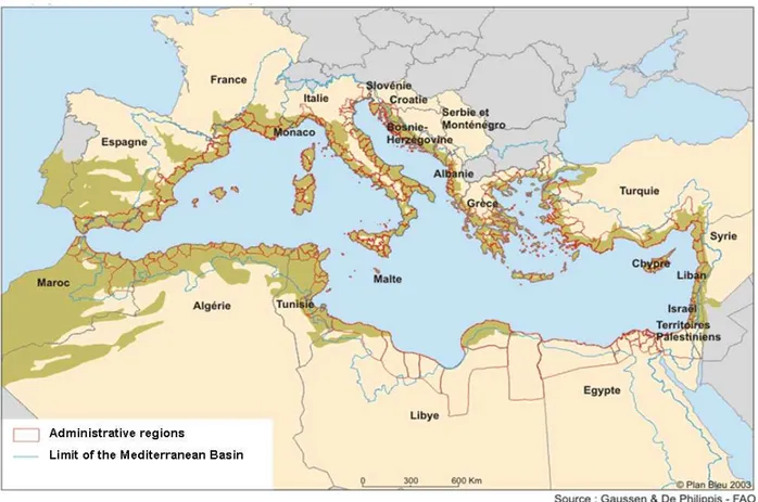
The Mediterranean basin covers portion of three continents (Europe, Asia and Africa) with twenty-one rim countries (Figure I) and a coastline of 46,000 km, 42% of which (i.e., 19,000 km) belong to several islands. The latter represents an invaluable asset not only because of the relevance of its ecosystems and its cultural heritage, but also for its social and economic functions (Coudert, 2007).
Figure I. The Mediterranean rim countries and the Mediterranean catchment Basin (Plan Bleu.org).
With the resources shared by all the rim countries, the Mediterranean is constantly exposed to human pressure on its general environment, and consequently victim of conflicts over natural resources, both at regional and international level. This is mainly due to increasing urbanization, agricultural activities along the coast, industrial sites, tourism and maritime circulation.
The main consequence is therefore the degradation of the milieu with often irreversible losses of biodiversity and alteration of the ecosystem functions.
According to the Blue Plan report (Coudert, 2007) the land-based contamination represents 80% of total pollution affecting coastal waters (the remaining 20% is due to off shore activities).
According to the same source, the main pollution spots in the Mediterranean are due to:
- Eutrophication (nitrogen and phosphorous nutrients stimulating the aquatic primary production), mainly originated from diffuse agricultural discharges;
- Chemical contaminations due to industrial draining;
-Organic and microbiological pollutions, caused by untreated domestic sewages and industrial wastewaters.
-Solid and dangerous wastes, which are the by-products of coastal districts (e.g. discharges from households, tourism and landfills generate between 30 and 40 million tons of solid waste per year).
In addition to these sources, another cause of habitats’ degradation and loss of biodiversity is the coastal erosion affecting a significant portion of the Mediterranean coastline. The phenomenon has been strongly exacerbated by anthropogenic action, with watershed development (solid inflows to the sea reduced by 90% over the past 50 years), sand extraction, construction of sea embankments and restructuring of the coasts.
Despiite their differences all those processes are all side effects of coastal overdevelopment (i.e.
concentration of people and activities on the coastal zone) in the Mediterranean area, which has been ongoing for several decades, leading to inevitable consequences on the natural environment.
While half of the world population is in process of becoming urban, in the Mediterranean rim countries two out of three inhabitants are already city-dwellers. By 2030, three quarters of the Mediterranean population will be urban (Laria, 2007), with severe environmental and social consequences (e.g. youth unemployment, lack of adequate infrastructures and services, pollution, domestic waste, increase in water demand).
The Mediterranean urban population (i.e. the population living in agglomeration of over 10,000 inhabitants) passed from 94 million in 1950 to 274 million in 2000. The reason of this increase, in particular for Southern and Eastern rim countries, has to be found in endogenous driving forces; despite the fertility rate is decreasing over the time, the urban population is growing thanks to internal redistribution and migration (inter-urban and rural to rural). However, countries like Tunisia and Egypt are experiencing a decreasing urbanization, while in countries like Morocco, Syria and Turkey migrations are still quite important. In the same way, Northern Mediterranean countries, which experienced a steady growth in past, nowadays show quite moderate growth rates (0.7% over the period 1970-2000) that are likely to continue in future.
According to the urbanization scenario for the Mediterranean region, by 2025, urban population would pass from 145 million inhabitants in 2000 to over 243 million in Southern and Eastern countries and from 129 million to about 135 million in the countries of the European rim. A third of this growth would take place in the Mediterranean coastal regions (Laria, 2007).
Particular attention should be paid to the features of urbanization in terms of city expansion. While the Northern shore is experiencing a general spreading of cities further and further away, in the Southern and Eastern shore this process is substituted by increase of informal settlements in the peripheral areas, as many people migrating from the countryside cannot afford houses in cities.
Informal settlements in urban outskirts are often lacking basic sanitation facilities and are more vulnerable to natural hazards, such as earthquakes, floods, landslides, with often catastrophic consequences.
All these factors should be taken into account while dealing with environmental management plans and, if on the one hand a more sustainable city development has to be promoted (e.g. more strict application of Agenda 21, endorsement of green transports, increase of projects of regeneration and renewal), environmental protection and natural resource preservation should be the first goal.
Based on this brief description, it emerges that despite sharing common catchment basin, Mediterranean rim countries are experiencing dissimilar situations, which have to be managed according to different
strategies, but according to a common general framework and involving a reinforcement of coastal policies.
Several projects and agreements have been carried out with this aim, and in all the numerous sectors of integrated management, both at regional-local and national-international level.
At the same time numerous conventions has been signed in order to protect the Mediterranean Sea and its precious resources.
All those conventions put the Mediterranean Sea ahead of all other seas in terms of management and environmental protection.
For example, at regional level, the riparian countries and the European Community signed in 1976 a common legal framework, the Barcelona Convention for the Protection of the Sea against pollution (and its Protocol for the Protection of the Mediterranean Sea Against Pollution from Land-Based Sources, signed in Athens on May 1980), which entered in force in 1978. This protocol was then revised in 1995 as the Convention for the Protection of the Marine Environment and the Coastal Region of the Mediterranean, though it is not yet in force.
The adoption by the Parties in the Barcelona Convention of a Protocol on Sustainable Management of Mediterranean Coastal Areas, in process of drafting, will provide a clear signal of the direction of new management approach, and it could help countries to develop or strengthen their policies (Coudert, 2007).
Other examples of adopted protocols on the protection of the Mediterranean basin are the following ones:
(UNEP 2009):
- The Protocol for the Prevention and Elimination of Pollution of the Mediterranean Sea by Dumping from Ships and Aircraft (Dumping Protocol); adopted in Barcelona (Spain) in 1976 (in force in 1978). This protocol was revised in 1995 as the Protocol for the Prevention and Elimination of Pollution of the Mediterranean Sea by Dumping from Ships and Aircraft or Incineration at Sea;
- The Protocol Concerning Cooperation in Combating Pollution of the Mediterranean Sea by Oil and other Harmful Substances in Cases of Emergency (Emergency Protocol); adopted in Barcelona (Spain) in 1976, in force since 1978;
- Protocol for the Protection of the Mediterranean Sea against Pollution from Land-Based Sources (LBS Protocol); adopted in Athens (Greece) in 1980, and in force since 1983, this protocol was amended in Syracuse (Italy) in 1996 as the Protocol for the Protection of the Mediterranean Sea against Pollution from Land-Based Sources and Activities;
- The Protocol Concerning Mediterranean Specially Protected Areas (SPA Protocol); adopted in Geneva (Switzerland) in 1982 (in force 1986), and revised in Barcelona (Spain) in 1995 as the Protocol Concerning Specially Protected Areas and Biological Diversity in the Mediterranean (SPA and Biodiversity Protocol);
- The Protocol for the Protection of the Mediterranean Sea against Pollution Resulting from Exploration and Exploitation of the Continental Shelf and the Seabed and its Subsoil (Offshore Protocol), adopted in Madrid (Spain) in 1994;
- The Protocol on the Prevention of Pollution of the Mediterranean Sea by Transboundary Movements of Hazardous Wastes and their Disposal (Hazardous Wastes Protocol); adopted in Izmir (Turkey) in 1996, but not yet in force.
More recently, but only at European level, the European Water Framework Directive (EWFD; Directive 2000/60/EC), came into force in 2000 to commit European Union member states to achieve good qualitative and quantitative status of all water bodies (including marine waters) by 2015. The purpose of the directive is to establish a framework for the protection of inland surface waters, transitional waters, coastal waters and groundwater in a broader sense and in order to promote sustainable water use and long-term protection of waters within Europe (European Commission, 2010).
In addition to the EWF, the Marine Strategy Framework Directive, adopted in June 2008, was designed to effectively manage the marine environment across Europe, thus including the Mediterranean sea and its coastal environments.
Moreover, in order to combat land-based pollution, as part of the implementation of the specific protocol of the Barcelona Convention, a Strategic Action Plan was adopted in 1997, and included in National Action Plans, setting ambitious objectives regarding pollution reduction up to 2025 (e.g. wastewater treatment of all coastal cities, reduction of industrial pollutants and of dangerous wastes). However, significant implementation difficulties persist in a context of increasing disparity of response capacity among the EU member countries or future members, and the other riparian countries (Coudert, 2007).
Despite the increasing attention and the amount of protocols signed to protect the Mediterranean basin ample room for progress still exists especially regarding the setting up of regulatory and institutional tools.
In 2004, only five countries (Algeria, France, Greece, Lebanon and Spain) already had a frame-law on the coastal zone, and three countries (Algeria, France and Tunisia) had coastal dedicated agencies (Coudert, 2007). Furthermore, it has to be underlined that if the implementation of adequate policies under the guidance of the European Union (Northern shore) is long and complex, the situation is even more difficult in the countries belonging to the so called Middle East and North African (MENA) region, occupying the Southern shore.
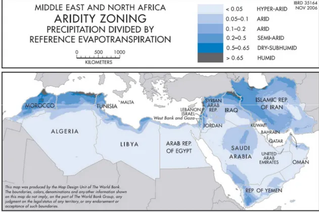
II.I. The Middle East and North Africa (MENA) region
According to the World Bank (as no unique definition/grouping exists) the acronym MENA (Middle East and North Africa region) groups the following African and Asian Countries: Algeria, Bahrain, Djibouti, Egypt, Iran, Iraq, Israel, Jordan, Kuwait, Lebanon, Libya, Morocco, Oman, Palestinian territories (the West Bank and Gaza Strip), Qatar, Saudi Arabia, Syria, Tunisia, United Arab Emirates and Yemen, with nine countries bordered by the Mediterranean Sea (Figure II).
The region as a whole accounts for about the 5% of world’s population (313 Million people in 2007; World Bank, 2009a). Less than 2% of MENA’s population lives on less than $1 a day while about 20% of the regional population lives on less than $2 a day (World Bank-MENA, 2009).
As a general feature, the majority of these countries is either in arid or hyper-arid zone (Figure II), they depend on seasonal rainfall, they have very few rivers (some of which carry runoff from other countries) and they often rely on fragile (and sometimes non renewable) aquifers.
Moreover, this region is one of the most vulnerable to climate changes; therefore the issue of water scarcity (the highest in the world) is of particular relevance for its social and economic consequences.
The dependence on climate-sensitive agriculture, the concentration of population and economic activity in flood-prone urban coastal zones, make this area particularly vulnerable to climate-induced problems, which can eventually escalate in violence and political turmoil, even beyond the region’s boundaries (World Bank, 2007a). This could be even worse in areas lacking of strong political and economic stability.
This is why in such a context it is of primary and vital importance to create integrated policies for water resource management.
As previously mentioned, since ancient times MENA region had to cope with difficult water conditions:
aridity, high variability, and high dependence on waters crossing international borders (e.g. Northern Sahara Aquifer System, shared among Algeria, Tunisia and Libya). Within this context a rational water management matters even more than it does elsewhere (World Bank, 2007b).
The combined action of population growth and foreseen climate changes will reduce the per capita water availability (50% by 2050) and both droughts and floods will be more frequent (IPCC, 2008).
Figure II. Countries of the MENA region and the associated aridity index (World Bank, 2007b).
Moreover, in such situation each region obviously has to take advantage of new technologies to answer both the increasing water demand due to population growth and the natural water scarcity. This in most of the cases leads to incapacity of regulators to effectively manage the natural resources (World Bank, 2007b).
In a context of poor water availability, high government expenditure on water infrastructures and inefficient water use, MENA countries are exhausting non renewable water resources (e.g. tapping groundwater for human consumption), polluting water bodies, damaging ecosystems and allowing
infrastructures to deteriorate through lack of maintenance (World Bank, 2007b). The consequences of these processes span at not only environmental level, but also affect the socio-economic sphere.
Over the years, MENA region has achieved significant improvements to cope with these problems and to accomplish a more sustainable water management. Nevertheless the process is still too slow (World Bank, 2009b), due to factors covering various sectors (e.g. not all the stakeholders have been involved in the decision processes, water reforms have been too impalpable and the accountability on the public has been to weak (World Bank, 2007a).
However, if on the one hand the process is slow, on the other hand MENA region has all the possibilities to meet its management water challenge. The best way to achieve these goals is to go over the classic sector-based approach, and consider the combined actions of all the factors contributing to the water question.
This means that the best way to tackle this problem is to use an integrated approach, and to start its application to the more vulnerable zone: the transition coastal systems (and in particular the lagoons).
III. The African shore and its lagoons
Several transition zones, wetlands and lagoons characterize the Mediterranean basin, representing a precious ecological heritage (Dakki, 2003).
The shallow shore and the abundance of rivers allow for the formation of several lagoons in both the European and the African littorals, whose classification is quite complex to handle.
This is mainly due to the absence of a univocal definition, and the relatively high number of wetlands in the Mediterranean basin.
Phleger (1967) defined costal lagoons as “shallow marine inland waters, usually oriented parallel to the coast, separated from the ocean by a barrier, and connected to the ocean by one or more restricted inlet”.
Kjerfve (1994) released a more practical definition, adding some details to the previous one: [a coastal lagoon is a] “shallow coastal water body separated from the ocean by a barrier, connected at least intermittently to the ocean by one or more restricted inlets, and usually oriented shore parallel”.
According to the climatic conditions, the presence of estuaries and other freshwater inputs, lagoons show different salinity ranges, spanning from completely freshwater to brackish or hypersaline waters (Kjerfve, 1994). Therefore, one can also classify lagoons according to other characteristics as salinity, estuarine nature, primary productivity, morphology or numbers of inlets.
For the purpose of the study, the adopted classification of coastal lagoons is the one proposed by Nichols and Allen (1981), which divides coastal lagoons into four categories:
1) Estuarine lagoons: areas where the intensity of the tide flows are more or less equal to the river flows;
2) Open lagoons: characterized by a high tidal range, that allows the natural opening of the inlet, and a permanent alimentation by seawaters;
3) Semi-closed lagoons, as the opposite of the open ones: the tidal range is not so strong to brush the sediments brought into the lagoon at the inlet level. Therefore, in most of the case there is the need for human intervention to maintain the inlet open;
4) Closed lagoons: ponds separated to the sea by a littoral spit and characterized by absence of seawater flows.
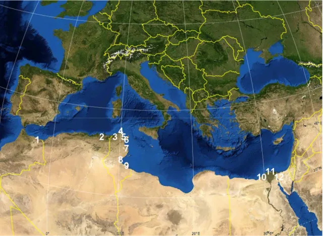
If we consider the Southern (i.e. African) shore several lagoons are present (Figure III), that have been mainly investigated considering their ecological and economic functions, with a general focus on aquaculture and fisheries activities (Vanden Bossche and Bernacsek, 1991).
Figure III. Location of the lagoons in the Southern Mediterranean shore. 1) Lagoon of Nador (or Sebkha Bou-Areg); 2) lake of El-Mellah; 3) Ichkeul Lagoon; 4) Bizerte Lagoon; 5) Ghar El Melh Lagoon; 6) Tunis lagoon; 7) Khenis Lagoon; 8) Bou Grara Lagoon; 9) Bahiret el Bibane Lagoon; 10) Burullus; 11) Manzalah; 12) Bardawil (Modif. Google Earth).
Divided county by country one can find the following lagoons (Figure III):
Morocco: the lagoon of Nador (or Sebkha Bou-Areg), as the only one in the Mediterranean side;
Algeria: a small lagoon in the extreme east of the country: lake of El-Mellah:
Tunisia: seven important coastal lagoons with a combined surface area of 550 km2 (e.g. Bahiret el Bibane Lagoon, Bizerte Lagoon, Ghar El Melh Lagoon, Ichkeul Lagoon, Khenis Lagoon, Tunis Lagoon and Bou Grara Lagoon);
Libya has no real inland lagoon of significant size. Farwa Lagoon, described in Lemoalle (1987), is widely open to the sea (salinity over 40‰) and therefore it cannot be included in the inland waters;
Egypt has an extensive surface area of coastal lagoons (2500 Km2) and the most characteristic are located in the deltaic zone of the Nile River (Figure IV).
The largest are Manzalah (900 km2), Bardawil (726 km2), and Burullus (560 km2).
The others are Port Fouad, Edku, Mariut, Um El Rish, Nozha Hydrodrome, Alamain and Matrooh.
Than there are the Great Bitter Lake and Small Bitter Lake and the Timsah Lake.
Figure IV. Location of the Egyptian lagoons located in the deltaic zone of the Nile River (Modif. Google Earth).
The strong morphological variety of these lagoons is associated to a biological richness, representing an important resource for the ecological value per se and in second instance for the attributed economic value. The mixing of seawater and freshwater creates, under particular climatic conditions, unique environments and rare ecosystems. The resulting high biodiversity makes these region particularly exposed to human settlements and exploitation.
Consequently, urbanization, agriculture, industrialization and tourism are threatening these singular and weak ecosystems. Moreover, in several cases all these effects are exacerbated by arid climate, and long dry seasons.
This is why Mediterranean lagoons must be protected and the ecosystems preserved from excessive exploitation and human induced contamination. In addition to that, impact of climate changes and the possible environmental scenarios have to be taken into account, and studied in order to avoid abrupt loss of biodiversity and magnification of water scarcity problems.
Under the need for a correct and integrated management, a series of agreement have been stipulated at international level, focused on wetlands protection.
Among the others, the most important is the Ramsar convention (from the name of the Iranian city where the convention was signed in 1971). This Convention on Wetlands is an intergovernmental treaty providing the framework “for national action and international cooperation for the conservation and wise use of wetlands and their resources” (Ramsar, 2009). There are presently 159 Contracting Parties to the Convention, with 1847 wetland sites, totalling 181 million hectares, designated for inclusion in the Ramsar List of Wetlands of International Importance. The mission statement is “the conservation and wise use of all wetlands through local and national actions and international cooperation, as a contribution towards achieving sustainable development throughout the world".
Strategic Partnership for the Mediterranean Sea Large Marine Ecosystem (SP-MED-LME)
As previously mentioned in 1975, 16 Mediterranean countries and the European Community signed the Mediterranean Action Plan (MAP), and the Barcelona Convention to protect the Mediterranean Sea from Pollution. The Mediterranean Action Plan was the first-ever plan adopted as a Regional Seas Programme under the UNEP umbrella (UNEP-MAP, 2010).
The main objectives of the MAP were: “to assist the Mediterranean countries to assess and control marine pollution, to formulate their national environment policies, to improve the ability of governments to identify better options for alternative patterns of development, and to optimize the choices for allocation of resources” (UNEP-MAP, 2010).
In the early stages of the Plan, the focus was controlling marine pollution in the Mediterranean Basin.
However, as environmental problems are often a side effect of socio-economic trends combined with inadequate management and development planning, Integrated Costal Zone Management and Planning were rapidly included as key issues of the Action.
In 2005 the Action Plan for the Protection of the Marine Environment and the Sustainable Development of the Coastal Areas of the Mediterranean (MAP Phase II) was designed, taking into account the achievements and shortcomings of the MAP in the context of recent developments (UNEP-MAP, 2010).
In the framework of Mediterranean Action Plan, Mediterranean rim countries, the World Bank, regional and international organizations and non-governmental organizations (NGOs) created a Strategic Partnership for the Mediterranean Large Marine Ecosystem (LME).
This Partnership represents the first project bringing together some of the main partners working in the Mediterranean for joint implementation of actions (UNEP-MAP, 2010), as well as the main international technical assistance and investment at Mediterranean level.
Its goals are to enable “a coordinated and strategic approach to catalyze the policy, legal and institutional reforms, and the investments necessary to reverse the degradation trends affecting this unique large marine ecosystem, including its coastal habitats and biodiversity” (UNEP-MAP-LME, 2010).
UNEP/MAP is the regional institution supporting and coordinating the implementation of the Barcelona Convention and Protocols adopted by all Mediterranean riparian countries to protect the marine and coastal environment. Global Environment Facility (GEF) and other partners, including the EU and all
participating countries, financially support the implementation of the project, as a contribution to the sustainable development objectives of the Union for the Mediterranean.
The Project is implemented in 13 GEF eligible countries: Albania, Algeria, Bosnia and Herzegovina, Croatia, Egypt, Lebanon, Libya, Morocco, Montenegro, Syria, Tunisia and Turkey. The Palestinian Authority also participates.
A preliminary action, the Transboundary Diagnostic Analysis (TDA), identified the 101 hot spots of environmental concern (Figure V) and provided a foundation for interventions at the national and regional level with expected outcomes both at local and at basin’s scale (UNEP, 2005).
Figure V. Mediterranean pollution hotspots (in Appelgren 2007).
As a second step, the actions for hot spots’ pollution remediation were identified and agreed in two Strategic Action Programs (SAPs):
- Strategic Action Programme for the Conservation of Mediterranean Marine and Coastal Biological Diversity (SAP-BIO), aiming at protecting biodiversity, living resources and their habitats;
- Strategic Action Programme to address pollution from land-based activities (SAP-MED) aimed at reducing land-based sources of marine pollution (UNEP, 2010).
Today SAP-MED involves 21 rim countries (and 13 recipient countries) “determined to meet the challenges of environmental degradation in the sea, coastal areas and inland, and to link sustainable resource management with development, in order to protect the Mediterranean region and contribute to an improved Mediterranean quality of life” (UNEP, 2010).
The two SAPs identify the major problems, indicate possible remedial measures and their cost, and set concrete targets and deadlines for their implementation.
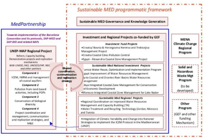
Figure VI, summarizes the main aspects of the Strategic Partnership.
Following the activities of all the involved partners, the main outcomes of the Strategic Partnership are planned to be (UNEP-MAP, 2010):
- a long term partnership for joint planning and financing in the Mediterranean basin;
- the improvement of environmental conditions in 15% of the hotspots and sensitive areas of national priority;
- more sustainable use of coastal resources through the implementation of Integrated Water Resource Management (IWRM), Integrated Coastal Zone Management (ICZM) and aquifer management;
- the reduction of pollution from land based sources through the demonstration and adoption of environmentally sound technology;
- more sustainable use of fisheries resources through the adoption of an ecosystem based approach to fisheries, and improved protection of critical biodiversity through the management of a coherent network of Marine Protected Areas; and
- the replication and scaling up of investment projects and demonstrations during the 5 year lifespan of the project.
Figure VI. Schematic representation of the ME-LME strategic Partnership (MED Partnership website).
UNESCO IHP is one of the executive partners for the development of regional projects within the Component 1 (Integrated approaches for the implementation of the SAPs and National Action Plans:
ICZM, IWRM and management of coastal aquifer).
The main objectives of this action are to “reverse the trends in over-extraction and degradation in the quality of coastal aquifers thorough policy interactions for providing appropriate capacity and technology for groundwater management and fill the existing knowledge gaps” (UNESCO-IHP, 2010).
In practical terms, its main activities are:
1. Assessing the risks to coastal aquifers and associated uncertainties;
2. preparation of a regional action plan, demonstrations in collaboration with ICZM and IWRM;
3. develop legislative, policy and institutional reforms;
4. monitoring and crosscutting activity (UNESCO-IHP, 2010).
Within the sub-component 1.1 (Management of Coastal Aquifers and Groundwater) executed by UNESCO-IHP, and under the activity “Assessment of risk and uncertainty related to Mediterranean coastal aquifers” a case study in the Nador Lagoon (North-East Morocco) was initiated in collaboration with the University of Venice, Department of Environmental Sciences (UNEP, 2010). The study is aimed at assessing the quality of the groundwater discharging to the lagoon, identifying human impacts on the groundwater quality and examining the possible occurrence of submarine discharge of polluted groundwater into the marine environment. Activities started at the end of 2009 and included:
(i) field trip, evaluation mission and scoping meeting with partners and national authorities in Rabat (Morocco);
(ii) exploration missions to Nador and identification of Moroccan Partners;
(iii) three hydrogeochemical sampling campaign undertaken in November 2009, June 2010, and November 2010, jointly performed with experts from Morocco (Faculté Pluridisciplinaire of Nador-University Mohammed I of Oujda, and Laboratoire des Sciences de l’Environnement et Développement Faculté des Sciences et Techniques, University of Settat).
The activities for the Nador case study constitute author’s doctoral research, focused on water quality, pollution and salinization hazards in both the lagoon and the near coastal aquifer, and have been performed accordingly to the research outlines and strategies described in the following section.
All the outcomes and results obtained so far are presented in this manuscript.
It must be underlined that the main innovative aspect of this work concerns the inclusion of coastal aquifers in coastal zone management studies, together with the investigation on the role of groundwater in sustaining coastal lagoon and wetlands.
Research outlines and strategies
Under the premise of the need for an integrated approach it is fundamental to take into account the relations between drainage basins (catchment areas) and aquifers through the near coastal zone, and to develop adequate science based policies oriented to achieve sustainable water management.
Furthermore, urban and agricultural settlements must be condidered, as their interactions change the natural systems through engineering structures, resource withdraw and waste discharge.
When human are present some other factors have also to be added to the ecological dimension. Health and economic well-being, hazards and vulnerability dynamics, legal and cultural rights, ownership and management structures, spiritual, investment needs and cost-recovery therefore make the processes of understanding and consequently decision making extremely complex (McDonnell, 2008).
To be effective a correct policy should consider these factors, and has to be based on robust and accountable data on both the baseline aquifer conditions and the origin and distribution of the human impacts (e.g. pollution, saline water intrusion etc.).
From a first literature review it appears that in the Mediterranean area relatively scarce attention has been paid to the role of the aquifers in the lagoon circulations (and the interaction between fresh groundwater and saline or brackish lagoon waters) if compared to surface circulation or biodiversity studies.
The reason of the general reduced attention to groundwater can be seen in its underground nature and the associated problems in having reliable data, and the difficulties of physically visualize the interactions with surface waters and the lagoon itself.
According to those assumptions, the proposed research project aims to deal with the complex issue of groundwater management in urban coastal areas in arid zones, in the big framework of the provision of safe and equitable water for human consumption and trying to consider all the gaps existing in the previous studies.
Hence specific objectives of the Nador case study in the framework of the UNESCO-IHP sub component of the SAP/MED are the following:
1. definition of the hydrochemical interaction between the lagoon and the aquifer;
2. identification of the principal geochemical units, to relate these to the geology and establish relations between units;
3. determination of the baseline conditions and the natural water quality;
4. identification and quantification of the impact of the human activities on the catchment area;
5. establishment of the suitability of the water for the domestic, agricultural and industrial use;
6. provision of advices for sound integrated coastal aquifer management.
Finally, the work aims at providing recommendations for the sustainable management of the groundwater resources of the Bou-Areg plain within the context of integrated coastal zone management and protection of coastal wetlands, lagoons and humid zones in the South shores of the Mediterranean.
There are therefore two purposes for this research in the case study area:
one is more strictly scientific related to the understanding of the hydrogeochemical model of the Bou-Areg plain and its interactions with the lagoon of Nador; the second directed to support the translation of the scientific findings into sustainable coastal zone management policies in Nador area, and more broadly along the Southern Mediterranean shore.
To tackle these objectives a multitracer geochemical approach was applied, with the main goal to identify the sources of salinization and to define the origin and fate of pollution impacts due to human activities.
Concerning the in situ measurements and sampling campaign for obtaining the data of the present work, a preparatory mission was performed in November 2009, allowing for the identification of the potential sampling sites and the definition of the main objectives of the following field investigation.
Then, the Spring 2010 and Fall 2010 fieldworks were more effectively focused on collection of groundwater samples in the Bou-Areg Plain and surface water in the Nador Lagoon, oued Selouane and the irrigation channel.
A fourth field work is scheduled for spring 2011 wich will allow for obtaining information on the seasonal variations within the studied system, and afeterwards all the data will be presented to the Moroccan institution, compared with the existing ones, and used to promote sustainable management practices in the area.
A detailed description of the in situ measurements and analytical procedures can be found in Chapter 3.
PART TWO
1. The study area: the lagoon of Nador and the Bou-Areg coastal aquifer
1.1. Physical geography
The areas proposed as pilot case study are the lagoon of Nador and the Bou-Areg coastal plain (Figure 1.1), located in the Mediterranean coast of Morocco, administrative region Oriental, province of Nador.
The region is also locally known as Grand Nador.
Figure 1. 1. Location of the lagoon of Nador (coordinates 35° 9'14.48"N, 2°51'4.19"O) and the Bou-Areg plain (Modif. Google Earth).
1.1.1. Morphology
Three main morphological units compose the area:
i) The Bou-Areg plain. Covering 190 Km2, it is a synclinal depression bounded to the North-West and West by the Gourougou and Beni Bou Ifrour massifs, to the South by the corridor of Selouane (linking the plain to the one of Gareb) and to the East by the Kebdana ranges (Chaouni Alia et al., 1997). The northern part of the plain coincides with the arched shape of the lagoon. The plain is characterized by the presence of salt marshes, intermittent streams (oued), some of which often serve as sewage outflow for urban areas upstream (Gonzales et al., 2007).
ii) The lagoon of Nador (also called Sebkha Bou-Areg or Mar Chica) is the only lagoon on the Mediterranean coast of Morocco. With a surface of 115 Km2 (Figure 1.1), a length of 24 km and a width of 7.5 km it is the second largest lagoon on the Mediterranean southern shore. The lagoon has an oval shape, NW-SE extension, and a depth not exceeding 8 m (Umgiesser et al., 2005; Figure 1.2A). The lagoon of Nador is characterized by semidiurnal tide and it has micro tidal regime as the water levels range from about 0.1 m at neap tide to about 0.5 m at spring tide (Brethes and Tesson, 1977; Umgiesser et al., 2005). The salinity varies from 39.5 to 43.5 psu over the year (Umgiesser et al., 2005).
A B
Figure 1. 2. A. Bathymetric chart of the lagoon of Nador (Dakki, 2003) and B Evolution of the inlet over the time (Modif.
Dakki, 2003).
iii) The coastal barrier oriented NW-SE with a length of about 25 Km and a width of 300-400 m (only the southernmost part reaches the maximal width of 2 Km) and characterized by the presence of a single inlet. During the past fifty year the cross section of the lido has changed several times (Figure 1.2B) and the inlet was often absent, as a result of wave action and littoral drift (Guelorget et al., 1987).
From 1987 the bokhana (or the actual position opened in 1981, after having been shut for two years) was progressively filled by sediments, until its closure in 1993 (Inani, 1995).
Dams, safeguarding the communication between the sea and the lagoon (Dakki, 2003), ensure the current position of the inlet. According to the new eco-touristic project involving the lagoon of Nador and
the surrounding area, launched by His Majesty, the King of Morocco, in June-July 2009, another inlet will be added to the current one 1.5 Km northward. The new inlet will be deeper (6 m instead of 3) and wider (300 m instead of 250) in order to increase water exchange rate between the sea and the lagoon (CAP Nador Action Plan, 2009).
1.1.2. Hydroclimatology
The climate of the region is mainly semi-arid and characterized by two pronounced seasons: the summer period from May to October, with average temperature of 20 °C and the winter season from November to April, with average temperatures of 12 °C. The cold est month is January, with minimum temperature values that could reach 5 or 7 °C (Figure 1.3 A).
However, seasonal variations are usually moderate, with a general high level of humidity (50-80%) due to the proximity to the sea (Figure 1.3 C).
A
B C
Figure 1. 3. Meteorological data for the period 2000-2008. (A). Mean monthly temperature; (B): Mean Annual temperature;
(C): Mean annual humidity (Unpublished data for the Meteo station WMO SYNOP DATA 60340: Nador, Latitude: 35-09N , Longitude: 002-55W, Altitude: 3m).