GEOMATICS TECHNIQUES FOR THE ENHANCEMENT AND PRESERVATION OF
CULTURAL HERITAGE
C. Balletti 1, B. Bertellini 1, C. Gottardi 1, *, F. Guerra 1 1
Laboratorio di Fotogrammetria, Università Iuav di Venezia, S. Croce 191, 30135 Venice, Italy (balletti, bbertellini, cgottardi, guerra2)@iuav.it
KEY WORDS: Cultural Heritage, Survey, Laser Scanning, Photogrammetry, Preservation, Geomatics, Virtual Reality
ABSTRACT:
The deep knowledge of Cultural Heritage, with historical research and interpretative analysis of materials, is fundamental to know the state of conservation and to plan potential restoration interventions. In the last years, thanks to the fast and continuous technological development, the metrical survey had a significant increase in this particular field: in fact, 3D digital acquisition allows to study some aspects otherwise difficult to investigate in a detailed way.
In this research, we will explain the methodology used for the ceiling’s survey of the Sala Capitolare of the Scuola Grande di San
Rocco in Venice, focusing on the support structure of Tintoretto’s paintings, anchored to a wooden system of Palladian trusses. The
complexity of this Venetian architecture, its considerable dimension, the richness of decorations and the particular lighting conditions provided the opportunity of thinking about unconventional choices to apply from time to time and they required the integration of different methodologies: the laser scanning survey and the photogrammetric acquisition, together with a topographic network, allowed to obtain an adequate metric result for the study of the structure in its entirety. Furthermore, it was also decided to test image acquisition with a spherical camera for the documentation of the analysed architecture: this type of information, more related to a viewable aspect than to a metric one, can be presented together with traditional 2D representations to ensure a better enhancement of the achieved results.
* Corresponding author
1. INTRODUCTION
The study of architectural buildings is fundamental for every activity concerning preservation and conservation of Cultural Heritage; in fact, the analysis of shape and geometry of an object is essential to know its state of conservation and to plan possible restoration interventions. In the last years, 3D digital acquisition techniques had a significant role in this particular field, providing a starting point for a complete awareness of historical architecture (Calantropio et al. 2018; Tucci et al., 2016). Nowadays, survey techniques are often integrated to obtain an accurate metric result, useful to the required representation scale (Kadobayashi et al. 2004): point clouds, achieved by both photogrammetric and laser scanning survey, ensure a geometric and qualitative description of an environment and allow further investigation, especially from a conservative point of view. The large amount of acquired information can also be subsequently used, on one side, as a real database for Cultural Heritage, providing the basis for three-dimensional models which could be queried (Historical Building Information Model) and, on the other side, for museum applications, allowing a wider audience to better appreciate historical architectures through virtual reality tools (Scandurra et al. 2018; Bitelli et al. 2017; Tucci et al. 2017). In this research, we will explain the methodology used for the ceiling’s survey of the Sala Capitolare of the Scuola Grande di
San Rocco in Venice, focusing especially on the support
structure of Tintoretto’s paintings, anchored to a wooden system of Palladian trusses. The Photogrammetry Laboratory of the Iuav University of Venice had often investigated wooden structures with peculiar geometrical complexities, developing an operational procedure, over time and through different case
studies, for the study of these construction techniques (Balletti et al., 2013; Balletti et al., 2003). Usually, an ancient building is a complex spatial system, where visible elements and interior parts, hidden to the visitor’s eyes, are strictly connected, in a continuous overlap of different constructive phases: for this reason, the metric acquisition is a fundamental phase which needs a detailed planning. This work was therefore an excellent case study that allows, first of all, to choose practical and fast solutions during the acquisition phase and, secondly, to test different approaches in order to provide new digital tools for the enhancement and conservation of Cultural Heritage.
The research here presented is divided into different parts: in the next paragraph, we will describe a state of the art regarding digital technologies used to document and enhance Cultural Heritage: in fact, nowadays, the integration of laser scanning and photogrammetric methodologies, together with a topographic approach, allows a very good interpretation of historical buildings. In the second section, some historical facts are briefly hinted, fundamental for the knowledge of an architecture. Subsequently, in the third paragraph, we will describe the phase of acquisition and processing of metric data, with the relative difficulties encountered and the solutions chosen in order to solve them; as we will explain, the major critical issue was encountered during the photogrammetric survey of the oil canvases, mainly due to the particular lighting conditions of the Sala. In the fourth chapter, we will describe the final representations obtained after data processing. The creation of a well-defined orthophoto with a high metric accuracy was essential for the paintings’ documentation; this data, together with vectorial drawings, allowed to depict the state of conservation of the Sala Capitolare (Fig. 1) and of the decorated ceiling. Moreover, we also generated a virtual tour of
The International Archives of the Photogrammetry, Remote Sensing and Spatial Information Sciences, Volume XLII-2/W11, 2019 GEORES 2019 – 2nd International Conference of Geomatics and Restoration, 8–10 May 2019, Milan, Italy
the Scuola Grande using spherical panoramas in order to share different information with a non-expert audience. At the end of the paper, in the last section, some conclusive considerations are presented, focusing on the importance of identifying operational procedures for the conservation of Cultural Heritage.
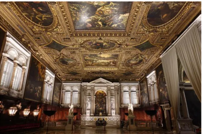
Figure 1. The Sala Capitolare of the Scuola Grande 1.1 Related work
The survey of decorated surfaces is a fascinating and complex topic and, at the same time, it allows testing innovative acquisition methods (Webb et al. 2018; Borgogno Mondino et al. 2005). Up to now, geomatic techniques are integrated to improve the qualitative investigation of paintings, correct graphic representations and an accurate knowledge of figurative decorations (Chiabrando et al. 2014; Apollonia et al. 2010; Armetta et al. 2009). The integration of multi-sensor systems is a procedure that is usually applied successfully in the conservation process to provide a metrically accurate data according to the needs and purposes of a project; moreover, it has been already analysed and tested in different ways by various researchers (Murtiyoso et al. 2018; Hassani 2015; Grussenmeyer et al. 2008). 3D documentation of historical sites or buildings can be done using both active and passive techniques. Each of these presents advantages and disadvantages and, especially for this reason, the two methods are usually integrated to ensure a complete metric information. The laser scanning survey is a range-based technique available since the 1980s which allows the acquisition of lots of points every second: it is a robotic total station that measures angles and distances. One of the main advantages compared to other topographic tools is certainly the possibility to obtain a lot of information in a short time, reducing the acquisition phase. On the other hand, among the main limits of a laser scanner there is certainly the difficulty of documenting surfaces with sharp edges and accurate radiometric values. In fact, even if the more recent instruments have an integrated digital camera, the lighting conditions do not always allow easy colour acquisition; for this reason, it is often necessary to integrate this technique with a photogrammetric survey.
In recent years, also thanks to the development of new user-friendly commercial software, the photogrammetric technique has been applied in many different fields; it is a method based on at least two images with overlapped data in order to guarantee the triangulation process. This technique is very useful for accurately documenting colours and texture of an object; one of the main advantages is definitely the possibility of obtaining metric data comparable to the laser scanning ones
but with a lower cost. Instead, a great disadvantage is the high technical skills needed to acquire and process data to achieve a final product suitable for the required scale: in fact, it is certainly not a technique that can be easily applied by non-experts, despite the new software simplified a lot the procedure and allow to quickly generate different products.
Usually, a DSLR camera is used in the most of photogrammetric surveys for the documentation of Cultural Heritage even though new low-cost digital sensors have been recently tested. In fact, there has been a rapid development of testing especially spherical photogrammetry applied to Cultural Heritage, both for purely commercial purposes and for tourism promotion, but also for three-dimensional metric documentation (Fangi 2017; Kwiatek et al. 2015; Barazzetti et al. 2018; Gottardi et al 2018; Fangi 2006). One of the main advantages of using spherical panoramas concerns their implementation in virtual reality tools: up to now, there are different procedures to generate a virtual environment using various input data, software and devices. We can currently identify two different approaches: the virtual reality, created starting from three dimensional data, and the virtual tour, which recreates a potential environment starting from images with a 360° field of view (Castagnetti et al. 2017). The advantages of these kind of applications are obvious: first of all, the involvement of the viewer, who can interact with the virtual environment that surrounds him. Secondly, the possibility of making available the Historical and Artistic Heritage to a wider public (Scianna et al. 2018; Napolitano et al. 2017; Osman et al. 2009): this is an accessibility that may eventually replace the real physical one when not possible (too expensive, dangerous or impractical situation). A third point concerns the chance of preserving, within a virtual memory, the Cultural Heritage in its current state of condition; moreover, it is also possible to virtually rebuild the historical environments damaged or destroyed by time or human’s actions to allow the spread of knowledge of our history.
2. THE SCUOLE GRANDI IN VENICE
Starting from the second half of the thirteenth century, in central and northern Italy, several confraternities of laymen with mutual aid purposes were established; in Venice, these aggregations were called Scuole (Tonon 1999; Pullan 1982). They had a very important role in the religious life and charitable assistance in the city; many of these were professional corporations of arts and crafts, others according to nationality or devotion, including the Battuti ones, identified as
Scuole Grandi. The Scuole Grandi had a fundamental role in
Venetian politics and society; for this reason, it seems unbelievable that such important organisations were founded afar from the Serenissima as, for example, in Perugia around 1260 from an ascetic flagellants’ movement.
Currently there are still six of these organisations in Venice:
Santa Maria della Carità, the oldest one, San Giovanni Evangelista, Santa Maria in Valverde or della Misericordia, San Marco, San Teodoro and San Rocco (Sansovino 1581).
2.1 The confraternity of San Rocco
Between the end of the thirteenth and the beginning of the fourteenth centuries, many towns were involved in serious epidemics of plague, including the Republic of Venice. After the Council of Constance (held between 1414 and 1418), many Italian cities, due to the inability of managing this situation, decided to establish confraternities in order to earn the patronage of the holy healer of this disease, namely San Rocco.
The International Archives of the Photogrammetry, Remote Sensing and Spatial Information Sciences, Volume XLII-2/W11, 2019 GEORES 2019 – 2nd International Conference of Geomatics and Restoration, 8–10 May 2019, Milan, Italy
In Venice, the first public act that declared the creation of the confraternity dated back to 1478 (November 30) and it is described in the Mariegola, a collection of community rules approved by the Consiglio dei Dieci institution. The confraternity was then elevated to the rank of Scuola Grande in 1489.
2.2 The Scuola Grande di San Rocco
At the beginning, the Scuola Grande di San Rocco changed locations a lot of times: only in 1486, eight years after its foundation, the confraternity found its definitive headquarters close to the Chiesa dei Frari.
The constructive evolution of the existing building was articulated in various phases, which reflected the succession of many different architects: Pietro Bon (between 1517 and 1524), Sante Lombardo (between 1524 and 1527), under the supervision of his father Tullio, and Antonio Abbondi (since 1527), called “lo Scarpagnino”, (Guidarelli 2002; Soravia 1824). The interventions were completed in 1560 by the director of works Giangiacomo de’ Grigi, who finished the roof, the skylights, the dormers and the spiral staircase to access to the roof-space.
2.3 Tintoretto and the painting cycle of the Sala Capitolare Jacopo Robusti, also known as Tintoretto (1519-1594), is considered, together with Tiziano and Veronese, one of the three most important artists of the sixteenth century in Venice. He was the son of Gian Battista tintore di sete (silk dyer) from which the name Tintoretto comes from; according to tradition, he also attended the bottega of the famous Tiziano and, at the age of twenty, he started working independently.
Even though the architecture of the Scuola can be considered completed in the mid-sixteenth century, the interior decoration was still unfinished. In 1564 the Scuola decided to hold a competition for the decoration of the Sala dell'Albergo and called the four most active artists in Venice: Veronese, Salvati, Zuccari e Tintoretto. The task was assigned to Tintoretto (1519-1594), who made the canvas and hanged it on the ceiling during the night with the complicity of the guardians, while the others were still concluding the first drafts to present. Subsequently, the Scuola called Tintoretto also for the realisation of the painting cycle of the ceiling of the Sala Capitolare between 1575 and 1577.
The ceiling of San Rocco realised by the Venetian painter represents one of his highest masterpieces, so that the Sala
Capitolare was also called the Sistine Chapel of Venice
(Romanelli 1994).
3. THE SURVEY OF THE SALA CAPITOLARE On the occasion of the 500th anniversary of the birth of Tintoretto, the Scuola Grande decided to investigate the building’s architecture in a detailed way, especially regarding the decorated ceiling, through an in-depth analysis of the whole structure. The complexity of the object, its considerable dimensions, the richness of decorations and the particular lighting conditions, required the integration of different acquisition techniques to obtain an adequate metric result for the study of the structure in its entirety. In particular, the work was divided into three different sections: the survey of the Sala
Capitolare, a wide and highly decorated accessible space, of the
roof environment, composed of three naves and divided by 28 Palladian trusses, and of the interstitial area in between, in which the wooden support system of the ceiling takes place.
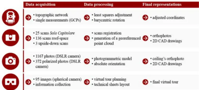
The next paragraphs describe the survey campaign (Fig. 2), the difficulties encountered and the solutions chosen in order to solve them.
Figure 2. The workflow applied in the survey campaign 3.1 The topographic survey
The first operation was the definition of a topographic network as a local reference system, in order to align all the subsequent laser scanning and photogrammetric information; measurements were acquired using the Leica TCR 1103 total station.
The only connection between the Sala Capitolare and the wooden structure under the roof is a narrow and steep spiral staircase: the materialisation of a topographic network inside the staircase would have caused many difficulties setting up instruments, extension of operations and a higher error propagation. To directly connect the different environments, we removed some wooden panels from the ceiling and we created some trap-doors at the planking level of the roof-space. Moreover, we materialised three points on the floor in the Sala
Capitolare. In the roof-space the instrument was set up on the
same ground points of the Sala, thanks to the trap-doors opened before; the Z-coordinate (the elevation) corresponds to the difference between the points on the main floor and the centre of the instrument. The distance was measured lowering a metric tape through the ceiling and verified also with a laser distance meter.
The two networks were adjusted separately with the least squares method implemented in the StarNet software (MicroSurvey StarNet): at the end, we obtained a standard deviation of about ±2 mm. In order to minimise the centering error of the upper points with respect to the main network, we also decided to apply a barycentric rotation obtaining final residuals of about ±5 mm.
At the same time, we also acquired some ground control points (GCPs) using single measurements to obtain the coordinates for georeferencing the laser scanning data and for the absolute orientation of photogrammetric models, positioning various checkerboards easily recognizable by the data processing software in the different environments.
3.2 The laser scanning survey
The laser scanning technique allows a fast digitisation and an easy visualisation of an object directly in a 3D environment, often including information about radiometric value.
The wooden roof, the Sala Capitolare and the support structure of the paintings were acquired using the phase-based laser scanner CAM2 Faro Focus 3D S120: this laser scanner is particularly suited for fast data acquisition (up to 976.000 points per second) maintaining a high level of precision (±2 mm in a range from 0.6 to 120 m). Specifically, the scans have been acquired with angular increments of 0.035°, in order to have a point every 6 mm at a distance of 10 meters.
The International Archives of the Photogrammetry, Remote Sensing and Spatial Information Sciences, Volume XLII-2/W11, 2019 GEORES 2019 – 2nd International Conference of Geomatics and Restoration, 8–10 May 2019, Milan, Italy
The number of scans depends on various factors, such as the object dimension and the presence of obstructions that may cause areas with no data acquisition. Due to the significant dimensions of this building (about 42x26.5 meters), we acquired 25 scans inside the Sala Capitolare, while in the roof-space, because of the Palladian trusses and the more articulated geometry, we needed to record 136 scans. Moreover, here, the planking level hides the interstitial space where it is positioned the ceiling’s support structure, including the anchorages of canvases. In order to obtain more information, some scans were also acquired inside the trap-doors positioning upside-down the laser scanner. The laser scanner is essential for acquiring information even in the absence of lighting as, for example, in the roof-space: the instrument uses an encoded light (active sensor) that is almost indifferent to the environment's conditions in which we operate.
All the scans were registered together in the local topographic system, applying a roto-translation to each cloud, thanks to the recognition of some targets and, when necessary, even with architectural points. Instead, concerning the scans performed in the interstitial area, it was not possible to acquire coordinates with topographic measurements; therefore, some homologous points of known coordinates (identified in other scans already registered) have been recognised during the processing phase. In this way, it was possible to visualise all the scans in the same topographic reference system (Fig. 3).
Figure 3. Point clouds of the different environments The high number of scans and their proximity to the analysed object allowed to obtain a very dense cloud of almost 7 billion points; the main problem of such a big amount of data is the difficulty in managing it during the elaboration phase.
For the alignment and the registration of the scans we used the Faro Scene software (CAM2 Scene): it easily recognises some signalisation systems, such as black and white checkerboard targets and spheres. Both these systems were used in the roof-space, while only the first one was applied in the Sala
Capitolare. At the end of the procedure, we obtained residual
errors of approximately ± 4 mm. 3.3 The photogrammetric survey
The most important part of this work concerned the photogrammetric acquisition and the subsequent models’ creation of the Sala and of the Tintoretto’s painting cycle. The ceiling was surveyed using the Nikon D800 digital camera with AF-S Nikkor 50 mm fixed lens; moreover, we also acquired some panoramic images with the Nikon Key Mission 360 spherical camera for the subsequent generation of a virtual tour. The photographic campaign has been divided into several days, because of the dimensions of the Sala and of the various problems encountered, including the particular lighting conditions, the constant presence of visitors, some obstructions and restoration works carried out during the survey campaign. The geometrical scheme for the photogrammetric survey of the ceiling required the acquisition of transversal and longitudinal
strips, keeping the camera’s optical axis both perpendicular and 45° inclined, with an overlap of 60% longitudinally and 50% transversally (Fig. 4).
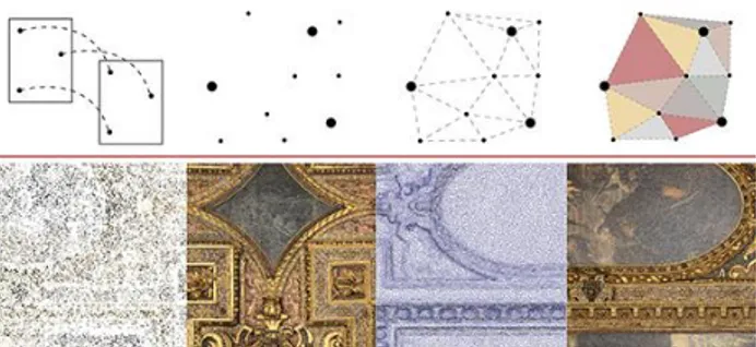
Figure 4. The image acquisition with the Nikon D800 The images were planned to obtain a GSD of 1 mm at a distance of about 10 meters. The photogrammetric model was produced starting from 1167 images processed with the software Agisoft Professional (Agisoft Photoscan). The acquisition geometry applied and the redundant overlap between photos allowed the creation of a complete point cloud, used subsequently for the generation of mesh and texture (Fig. 5).
Figure 5. The processing phases in Photoscan Especially in correspondence of portals and tympanums, we encountered many problems for the generation of texture: in fact, the projection of these elements hid some portions of the ceiling. We cleaned the model and removed all the points not concerning the ceiling. When even this operation was not enough, some masks were applied to single images to generate a new texture. Despite the advanced level of software automation, this phase required a long work in terms of time (3-4 full days), due to the high number of photos.
The interior orientation parameters were estimated together with the external relative orientation, so simultaneously to the photogrammetric model’s generation (self-calibration). For the absolute orientation of the photogrammetric model, 10 ground control points (GCPs) were homogeneously distributed on the entire surface: the coordinates were obtained directly from the laser scanning point cloud. We decided not to directly acquire the coordinates during the topographic survey with the total station due to the complex operating conditions encountered: in fact, the constant presence of visitors and ongoing maintenance interventions inside the Scuola forced a reduction in terms of acquisition time; this determined a choice of points to be topographically acquired and, for this reason, we decided to measure only the targets positioned in the different environments.
Therefore, after applying a roto-translation with scale variation at the end of the photogrammetric process, the residuals
The International Archives of the Photogrammetry, Remote Sensing and Spatial Information Sciences, Volume XLII-2/W11, 2019 GEORES 2019 – 2nd International Conference of Geomatics and Restoration, 8–10 May 2019, Milan, Italy
obtained were about ± 1 mm. In order to have a rigorous control of the photogrammetric block’s accuracy, we evaluated the results using also some check points: we used the coordinates estimated by Photoscan to calculate the RMSE with respect to the coordinates of the same points obtained from the laser scanning cloud. As we can see from the table below (Tab. 1), the residuals on the check points are higher than those on the GCPs, but they still ensure an accuracy of the final product for the required scale (1:50).
Ground Control Points (10)
RMSE X RMSE Y RMSE Z Total Error 0.0006 m 0.0008 m 0.0008 m 0.0013 m
Check Points (6)
RMSE X RMSE Y RMSE Z Total Error
0.0052 m 0.0047 m 0.0056 m 0.0090 m Table 1. The RMSE of GCPs and of checkpoints Nevertheless, we decided to generate an orthophoto with a smaller pixel size (1 mm) only in order to obtain a better resolution in terms of visualisation. Moreover, the precision obtained in the model orientation is not to be considered absolute for the object space defined by the topographic survey, but relative to the congruence between the laser scanning and photogrammetric cloud.
The main critical issue of the photogrammetric survey concerned problems due to the illumination system designed by the Venetian artist Mariano Fortuny (1871-1949): lights, oriented from bottom to top, ensure an optimal visualisation of the space, but they have caused overexposed areas in correspondence of oil paintings. In fact, the first orthophoto shows many reflections that do not allow a correct canvases’ visualisation (Fig. 6).
Figure 6. The first ceiling’s orthophoto obtained Therefore, in order to overcome this situation, the overexposed photos were excluded from the process, but the model was incomplete, because the images used were not enough to cover the entire decorated surface. We tried to avoid the problem of reflection by acquiring photos keeping the camera’s optical axis inclined with a radial acquisition scheme, but the orthophoto was characterised by larger pixels (about 3 mm), due to the inclination of the camera and then to a non-homogeneous frame scale.
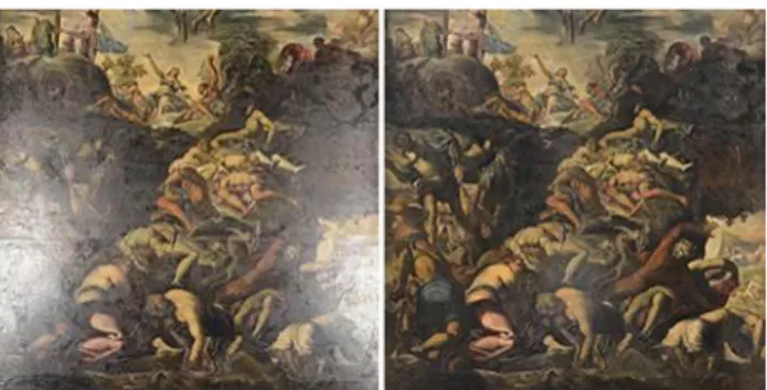
The lighting problem was solved using a polarizer filter Hoya CIR-PL Ø58. This one, screwed on the camera lens, minimises the passage of light reflected from surfaces, polarizing a part of the light itself and excluding some frequencies of the visible spectrum. The filter is composed of two different lenses: the first one directs the polarization plane and the second one allows the auto-focus to work. The filter also reduces the luminous intensity, increases contrast and saturates colours (Fig. 7). All the photos were acquired again using the polarizer
filter and then elaborated in Photoscan. Thanks to this procedure, the number of identified tie points increased during the photogrammetric process (Georgopoulos et al. 2010; Guidi et al. 2014). Moreover, in this specific case, giving the plain surface of the object and the acquisition schemes used, we did not find considerable deformations due to the filter.
Figure 7. A painting before and after the use of the polarizer The final orthophoto (Fig. 8) of the whole ceiling was generated by placing the paintings’ orthophoto obtained with the polarizer on the wooden frame achieved in the previous photogrammetric survey. This was possible because all the paintings were referenced in the same system through the detection of points from the laser scanning data; at the end of the procedure, the residuals were similar to the previous model’s ones. Also in this case, we decided to set the orthophoto pixel size equal to 1 mm only in order to better visualise the wooden frame and the paintings.
Figure 8. The final orthophoto obtained 4. THE FINAL REPRESENTATIONS 4.1 2D drawings
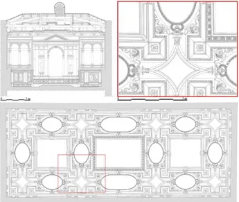
The point clouds were subsequently used for the digitisation of some graphical representations. Thanks to a Recap Pro plug-in (Autodesk Recap) it is possible to visualise the clouds directly in the AutoCAD environment (Autodesk AutoCAD) in order to generate traditional drawings, such as horizontal and vertical sections, or to realise three-dimensional models. The software allows to set, for instance, the section lines that, in this case, were identified in the middle of the canvases to obtain the useful information about the ceiling’s support structure and its deformations.
This work ensures to record for the first time the state of condition of this important Venetian architecture; we realised the traditional drawings of the surveyed environments for the 1:50 scale, according to the demand of the confraternity (Fig. 9). The achieved results were very useful to the Scuola Grande for an in-depth analysis of the Sala Capitolare and its state of conservation; in fact, the drawings provide an accurate metric support for planning future restoration and maintenance works.
The International Archives of the Photogrammetry, Remote Sensing and Spatial Information Sciences, Volume XLII-2/W11, 2019 GEORES 2019 – 2nd International Conference of Geomatics and Restoration, 8–10 May 2019, Milan, Italy
Figure 9. 2D digital representations of the Sala Capitolare At the end of the digitisation phase, we realised four transversal and two longitudinal sections and the ceiling’s plan: this one was drawn using both the laser scanning point cloud and the photogrammetric orthophoto generated with the D800 images. This procedure was necessary mainly for representing some elements’ decoration: in fact, the photogrammetric orthophoto, differently from the laser scanning information, ensures a better qualitative description keeping the same precision.
Furthermore, the scans acquired in the interstitial space between the ceiling and the planking level of the roof-space, allow to obtain information about a totally unknown area, even though its relevance: in fact, in this part, it is located the wooden ceiling’s support structure, including the anchorages of the Tintoretto’s canvases.
Finally, the surveyed data, the drawings and the ceiling’s orthophoto, will be used by Ca’ Foscari University of Venice as a starting point for various chemical analysis; in fact, the Department of Environmental Sciences, Informatics and Statistics is investigating, on one side, the quality of the air in the Sala and, on the other side, the original colours used by Tintoretto for the ceiling’s canvases. In this regard, drawings will be used to properly place filters for analysing the presence of particulate and dust inside the Sala Capitolare, while the photogrammetric orthophoto will be used by restorers as a starting point for the study of original radiometric values of canvases. At the end of the process, the large amount of acquired data and elaborations allow a complete representation of the Scuola Grande di San Rocco and of the Tintoretto’s paintings in an adequate level of detail.
4.2 The virtual tour of San Rocco
Finally, regarding a new awareness of historical and artistic contents in the museums, we decided to investigate the use of spherical images applied to virtual reality applications in order to enhance Cultural Heritage, providing an added value to the
Scuola Grande and spreading the knowledge to a wider
audience.
The term “virtual tour” refers to a simulated visit of a place obtained by connecting different spherical images. The virtual reality of San Rocco was planned in order to let interact visitors with both Tintoretto’s paintings and the wooden structure, which is not usually viewable. We planned a hybrid system, using both the spherical images of the Key Mission 360 and the
panoramas that can be generated directly from the Faro Scene software. In this way, thanks to information recorded by the laser scanner, it was possible to create equirectangular projections and use them to better appreciate a space hidden to the majority of visitors. In this work, we decided to test the 3D Vista (3Dvista Virtual Tour) software: after choosing the panoramas, we set the main display mode and determined the path placing some hotspots; those ones can be icons or polygons containing different types of information such as images, texts or videos. The tour was composed of five panoramas: we placed two spherical images inside the Sala
Capitolare, the first one focused on canvases while the second
one gave a general overview of the Sala. The information inside the tour is different: there are, for example, the orthophoto obtained with the D800 images, panes about history of the
Scuola Grande and the Sala Capitolare, 21 technical sheets
about Tintoretto’s canvases, CAD drawings of the interior facades and a video of the point cloud that better shows the roof environment (Fig. 10).
Figure 10. The virtual tour in the roof environment Moreover, in order to simplify the tour visualisation, we uploaded the plans of the Sala and of the roof-space, redrawn starting from the laser scanning data: here, the position of the panoramas and the optic cones were also shown.
Figure 11. The virtual tour displayed in different devices After planning the tour’s path and uploading the information sheets, we completed the creation of the virtual reality with the spherical cameras of the Scuola Grande di San Rocco (Fig. 11). It is also possible to export the project either for a web visualisation or in a stand-alone version, without requiring a continuous internet connection; thereafter, we checked the results also through immersive visualisation with head-mounted displays.
Furthermore, the tour could also be used as a multidisciplinary approach, including in the virtual environment also the
The International Archives of the Photogrammetry, Remote Sensing and Spatial Information Sciences, Volume XLII-2/W11, 2019 GEORES 2019 – 2nd International Conference of Geomatics and Restoration, 8–10 May 2019, Milan, Italy
researches and results obtained by restorers: in this way it will be possible, both for specialists and for visitors, a virtual interaction with the restored Tintoretto’s paintings and with their original colours, thus allowing to improve knowledge and promotion of such a representative and unique place in Venice. In fact, also thanks to virtual musealisation it is possible to enhance the educational and cultural sectors and to spread communication between public institutions.
5. CONCLUSIONS
Up to now, the continuous development of both hardware and software tools allows to acquire data and to produce elaborations useful for a complete awareness of an object in a relatively short time. The structural and conservative analyses of an architecture have to firstly take into account the shape of the case study: for this reason, the geometrical survey must be planned at the beginning of a project and it must guarantee the accuracy necessary for further analyses. As an essential step for the knowledge process, the survey can ensure the preservation of Cultural Heritage and its historical and material enhancement.
This work describes the methodology applied for the survey of the ceiling of the Scuola Grande di San Rocco. Historical buildings often show problems related to the geometrical complexity that characterises them; for this reason, survey operations must be set time by time in order to solve critical issues that the building requires.
Thanks to the laser scanning survey we acquired a large amount of data in such a short time and also in absence of light; in fact, measuring the elements of the roof-space with other techniques and tools would have been rather complicated. On the other hand, if an in-depth analysis of radiometric values of canvases is required, as in this specific case, the camera embedded in the laser scanner does not allow an adequate registration of this kind of information. For this reason, we decided to integrate data with a photogrammetric survey; in spite of a longer acquisition and elaboration time and the higher performance tools needed, the final product was suitable for the prefixed aims both on metric and radiometric aspects. Moreover, the polarizer has significantly improved the quality of the final products.
Furthermore, obtaining a complete 360° documentation of an architecture has a great importance and effectiveness: the enhancement of Cultural Heritage using spherical panoramas for the creation of virtual reality has shown good results. This type of information, more related to a viewable aspect than to a metric one, can be presented together with traditional drawings of the architectural representation, to ensure a better enhancement of the achieved results.
Finally, the great amount of data acquired could be used for further proposals especially concerning the integration with restoration activities. For example, a possible development could consist in implementing the virtual tour also with useful information for preservation, thus allowing the restorers to access in real time to a simple database in which it is possible to catalogue all the applied procedures from time to time. In fact, activities related to the removal of accumulated dirt, patinas and alterations caused by the environment and particulate are irreversible actions that require an in-depth documentation and continuous planning of operations. As a result, this multi-level awareness obtained with a multi-disciplinary approach will allow to disseminate the acquired knowledge both to specialist and to non-expert users.
ACKNOWLEDGEMENTS
The authors would like to thank dott. Gianluca Romagna for the co-operation in this research and the Scuola Grande di San
Rocco for the helpfulness during the survey operations and the
continuous interest demonstrated. REFERENCES
Apollonia, L., Salonia, P., 2010. Rilievo architettonico propedeutico al restauro della Cappella di Saint-Maxime a Challand-Saint-Victor. Bollettino della Soprintendenza BB.CC.AA. della Regione Autonoma Valle d’Aosta, vol. 6, pp.
262-272.
Armetta, V., Giordano, A., Lo Brutto, M., Tumminello, A., 2009. Tecniche fotogrammetriche digitali per la conservazione e il restauro di apparati decorativi. Scienza e patrimonio culturale nel mediterraneo. Diagnostica e conservazione: esperienze e
proposte per una carta del rischio. I Quaderni di Palazzo
Montalbo, n.15.
Balletti, C., Berto, M., Gottardi, C., Guerra, F., 2013. Ancient structures and new technologies: survey and digital representation of the wooden dome of SS. Giovanni e Paolo in Venice. ISPRS Annals, vol. II-5/W1, pp. 25-30.
Balletti, C., Guerra, F., Gerbaudi, F., 2003. The survey of the wooden structure of the roof of Palazzo Ducale in Venice.
ISPRS Archives, vol. XXXIV-5/W12, pp. 49-53.
Barazzetti, L., Previtali, M., Roncoroni, F., 2018. Can we use low-cost 360 degree cameras to create accurate 3D models?
ISPRS Archives, vol. XLII-2, pp. 69-75. https://doi.org/10.5194/isprs-archives-XLII-2-69-2018
Bitelli, G., Balletti, C., Brumana, R., Barazzetti, L., D'Urso, M.G., Rinaudo, F., Tucci, G., 2017. Metric documentation of cultural heritage: Research directions from the Italian gamher project. ISPRS Archives, vol. XLII-2, pp. 83-90. https://doi.org/10.5194/isprs-archives-XLII-2-W5-83-2017 Borgogno Mondino, E., Grua, M., Lingua, A., Giulio Toniolo, F., 2005. Tecniche innovative per il rilievo multispettrale di affreschi murali. IX Conferenza Nazionale ASITA, Catania, Italia, pp. 445-450.
Calantropio, A., Patruccio, G., Sammartano, G., Teppati Losè, L., 2018. Low-cost sensors for rapid mapping of cultural heritage: first tests using a COTS Steadicamera. Applied
Geomatics, vol. 10, n. 1, pp. 31-34. https://doi.org/10.1007/s12518-017-0199-6
Castagnetti, C., Giannini, M., Rivola, R., 2017. Image-based virtual tours and 3D modeling of past and current ages for the enhancement of archaeological parks: the VisualVersilia 3D project. ISPRS Archives, vol. XLII-5, pp. 639-645. https://doi.org/10.5194/isprs-archives-XLII-5-W1-639-2017 Chiabrando, F., Lingua, A., Noardo, F., Spanò, A., 2014. 3D modelling of trompe l'oeil decorated vaults using dense matching techniques. ISPRS Annals, vol. II-5, pp. 97-104. https://doi.org/10.5194/isprsannals-II-5-97-2014
Fangi, G., 2017. The book of spherical photogrammetry. Theory
and experiences. Edizioni Accademiche Italiane.
The International Archives of the Photogrammetry, Remote Sensing and Spatial Information Sciences, Volume XLII-2/W11, 2019 GEORES 2019 – 2nd International Conference of Geomatics and Restoration, 8–10 May 2019, Milan, Italy
Fangi, G., 2006. Investigation On the suitability of the spherical panoramas by Realviz Stitcher for metric purposes. ISPRS
Archive, XXXVI-5.
Georgopoulos, A., Ioannidis, Ch., Valanis, A., 2010. Assessing the performace of a structured light scanner. ISPRS Archives, vol. XXXVIII-5, pp. 250-255.
Gottardi, C., Guerra, F., 2018. Spherical images for Cultural Heritage: survey and documentation with the Nikon KM360.
ISPRS Archives, vol. XLII-2, pp. 385-390. https://doi.org/10.5194/isprs-archives-XLII-2-385-2018 Grussenmeyer, P., Landes, T., Voegtle, T., Ringle, K., 2008. Comparison methods of terrestrial laser scanning, photogrammetry and tachometry data for recording of cultural heritage buildings. ISPRS Archives, vol. XXXVI, pp. 213-218. Guidarelli, G., 2002. Una giogia ligata in piombo: la fabbrica della Scuola Grande di San Rocco in Venezia, 1517-1560.
Quaderni della Scuola Grande Arciconfraternita di San Rocco,
n. 8.
Guidi, G., Gonizzi, S., Micoli, L.L., 2014. Image pre-processing for optimizing automated photogrammetry performaces. ISPRS
Annals, vol. II-5, pp. 145-152. https://doi.org/10.5194/isprsannals-II-5-145-2014
Hassani, F., 2015. Documentation of cultural heritage techniques, potentials and constraints. ISPRS Archives, vol. XL-5, pp. 207–214. https://doi.org/10.5194/isprsarchives-XL-5-W7-207-2015
Kadobayashi, R., Kochi, N., Otani, H., Furukawa, R., 2004. Comparison and Evaluation of Laser Scanning and Photogrammetry and Their Combined Use for Digital Recording of Cultural Heritage. ISPRS Archives, vol. XXXV (B5), pp. 401-407.
Kwiatek, K., Tokarczyk, R., 2015. Immersive Photogrammetry in 3D Modelling. Geomatics and Environmental Engineering, vol. 9, n. 2, pp. 51-62.
Murtiyoso, A., Grussenmeyer, P., Suwardhi, D., Awalludin, R., 2018. Multi-Scale and Multi-Sensor 3D Documentation of Heritage Complexes in Urban Areas. ISPRS International
Journal of Geo-Information, vol. 7, n. 12, 483. https://doi.org/10.3390/ijgi7120483
Napolitano, R.K., Douglas, I.P., Garlock, M.E., Glisic, B., 2017. Virtual tour environment of Cuba’s National School of Art. ISPRS Archives, XLII-2, pp. 547- 551. https://doi.org/10.5194/isprs-archives-XLII-2-W5-547-2017 Osman, A., Wahab, N.A., Ismail, M.H., 2009. Development and Evaluation of an Interactive 360° Virtual Tour for Tourist Destinations. Journal of Information Technology Impact, vol. 9, n. 3, pp. 173-182.
Pullan, B., 1982. Le scuole grandi, l'assistenza e le leggi sui poveri. La politica sociale della Repubblica di Venezia,
1500-1620, vol. 1, Roma, Il veltro.
Romanelli, G., 1994. Tintoretto: la Scuola Grande di San
Rocco. Milano, Electa.
Sansovino, F., 1581. Delle Fraterne o Scuole Grandi. Venetia
citta nobilissima et singolare, vol. VII, Venezia.
Scandurra, S., Pulcrano, M., Cirillo, V., Campi, M., di Luggo, A., Zerlenga, O., 2018. Integrated survey procedures for the virtual reading and fruition of historical buildings. ISPRS
Archives, vol. XLII-2, pp. 1037-1044. https://doi.org/10.5194/isprs-archives-XLII-2-1037-2018 Scianna, A., La Guardia, M., 2018. 3D virtual CH interactive information systems for a smart web browsing experience for desktop pcs and mobile devices. ISPRS Archives, XLII-2, pp. 1053-1059. https://doi.org/10.5194/isprs-archives-XLII-2-1053-2018
Soravia, G., 1824. La Chiesa e la Scuola Grande di San Rocco.
Le Chiese di Venezia illustrate e descritte, vol. 3, Venezia.
Tonon, F., 1999. La Scuola Grande di San Rocco nel Cinquecento attraverso i documenti delle sue Mariegole.
Quaderni della Scuola Grande Arciconfraternita di San Rocco,
n. 6, Venezia, Grafiche Veneziane.
Tucci, G., Bonora, V., Conti, A., Fiorini, L., 2017. High-quality 3D models and their use in a cultural heritage conservation project. ISPRS Archives, vol. XLII-2, pp. 687-693. https://doi.org/10.5194/isprs-archives-XLII-2-W5-687-2017 Tucci, G., Bonora, V., Fiorini, L., Conti, A., 2016. The Florence Baptistery: 3-D Survey as a Knowledge Tool for Historical and Structural Investigations. ISPRS Archives, pp. 977-984. https://doi.org/10.5194/isprs-archives-XLI-B5-977-2016
Webb, E.K., Robson, S., MacDonald, L., Garside, D., Evans, R., 2018. Spectral and 3D cultural heritage documentation using a modified camera. ISPRS Archives, vol. XLII-2, pp. 1183-1190. https://doi.org/10.5194/isprs-archives-XLII-2-1183-2018
3DVista Virtual Tour: https://www.3dvista.com Agisoft Photoscan: http://www.agisoft.com Autodesk AutoCAD: https://www.autodesk.it/products/autocad/overview Autodesk Recap: https://www.autodesk.com/products/recap/overview CAM2 Scene: https://www.faro.com/it-it/prodotti/design-del-prodotto/faro-scene MicroSurvey StarNet: http://www.microsurvey.com/products/starnet/
The International Archives of the Photogrammetry, Remote Sensing and Spatial Information Sciences, Volume XLII-2/W11, 2019 GEORES 2019 – 2nd International Conference of Geomatics and Restoration, 8–10 May 2019, Milan, Italy