NEW VISUALIZATION
TOOLS FOR SCIENCES AND
HUMANITIES: DATABASES
AND VIRTUAL REALITY
Thesis for the Degree of Doctor of Philosophy
in Chemistry
Author:
Jacopo Baldini
Supervisor:
Vincenzo Barone
Contents
JACOPO BALDINI 2
Jacopo Baldini: New Visualization Tools for Sciences and Humanities: Databases and Virtual Reality, © November 2017
Contents
JACOPO BALDINI 3
Abstract
Within the scientific view, one of the major problems related to simulations developed for Virtual Reality, more specifically in research, is mainly related to the poor development of interaction between the data being displayed in the database in which they are contained, combined with the difficulty of making everything directly accessible in virtual environment. In Digital Humanities, it becomes increasingly necessary to have an instrument capable of combining scientific visualization in Virtual Reality with the access and consultation of an open repository.
The work done for this thesis is based on the creation of a heterogeneous relational database called ArcheoDB, run by an open web platform, on which researchers can upload 3D content and share them with their own collaborators. The web platform and the database are alongside an application called "ArcheoDB VR Toolkit" developed with Unity Engine, which dynamically loads contents within the ArcheoDB database and visualizes them in a complex scene. This application also provide a detailed reconstruction of the various objects, the background of the discovery and the chemical analyzes made in a highly immersive way, thanks to the use of immersive visualization.
Likewise, in order for the application to be 3truly innovative, it must allow not only to display 3D data, but also to interact in real time with the displayed models, enabling to enrich and
Contents
JACOPO BALDINI 4
modify them, based on data consultation and metadata drawn from the database.
Contents
JACOPO BALDINI 5
Contents
Contents ... 5
Aim of the thesis ... 7
Chapter 1 - Virtal Reality ... 8
Chapter 2 - Devices for Virtual Reality ... 11
Chapter 3 - Virtual Reality and Augmented Reality for Scientific Visualization ... 14
Chapter 4 - Virtual Reality in Archeology ... 16
Chapter 5 - Chemistry in cultural heritage ... 22
Chapter 6 - State of the art ... 24
Chapter 7 - Case studies ... 32
7.1 Kaulonia Virtual Reconstruction ... 32
7.2 Aghia Triada in Virtual Reality ... 49
7.3 Praedia of Iulia Felix ... 58
Chapter 8 - ArcheoDB Project - Archaeological Database for Virtual Reality ... 67
8.1 Create dynamic and multi-platform web platform: ... 68
8.2 Creating the 3D Model Database ... 68
8.3 Total transparency of the interface and data ... 68
8.4 ArcheoDB VR Toolkit for Virtual Reality ... 70
Chapter 9 - ArcheoDB Technical Implementation ... 71
9.1 ArcheoDB Database ... 71
9.2 User Database ... 72
9.3 Database Workgroup ... 73
9.3.1 Creating a Workgroup ... 73
9.3.2 Enter an existing Workgroup ... 74
9.3.3 File Database ... 75
9.3.4 Collections Database ... 76
9.3.5 Storage of uploaded files ... 77
JACOPO BALDINI 6
9.5 File Repository ... 78
Chapter 10 - ArcheoDB VR Toolkit ... 79
10.1 Supported Head Mounted Displays ... 81
10.2 Unity Game Engine ... 81
10.3 Database Direct Connection ... 82
10.4 Models and 3D Scenes ... 83
10.4.1 Mode View: Single 3D model ... 84
10.4.2 Mode View: Scenery 3D ... 84
10.4.2.1 Scenery Mode: Background ... 85
10.4.2.2 Scenery Mode - Illumination ... 85
10.4.2.3 Scenery Mode - 3D Models ... 86
10.4.2.4 Scenery Mode - Display Type ... 87
10.4.2.5 Scenery Mode - Interaction Type ... 87
Chapter 11 - Unity Workflow ... 89
11.1 Unity Project ... 89
11.2 Assets ... 90
11.3 Database Connection ... 92
Chapter 12 - Conclusions and future work ... 93
References ... 95
Aim of the thesis
JACOPO BALDINI 7
Aim of the thesis
The work described in this thesis concerns the development of a heterogeneous platform consisting of a web database and a multi-device application for displaying scientific data that can be used by different devices in order to facilitate management of knowledge and collaboration among researchers. The first part of the work consists of the creation of an open source online platform connected to a database that can store 3D content, metadata and related information. Researchers will be able to create their own profile and workgroups and upload their 3D models.
The second part of the work consists in creating a multi-device application that can visualize via Virtual Reality, 3D objects with its metadata, allowing researchers to work directly on datas and upload them from the database in real-time. This type of tool will be able to display not only objects but also complex scenes, such as reconstructions of archaeological contexts and excavations. One of the main focuses of the application is to provide not just a simple 2D desktop display, but an application specifically designed for Virtual Reality and its use through HMD (Head Mounted Displays) (Figure 1.1) and C.A.V.E (Cave Automatic Virtual Environment) devices. In this way, it is possible to view a 3D model or an entire reconstruction by choosing the visualization method (HMD, CAVE, Desktop) and interacting with the virtual world using innovative and new immersive interaction systems and methods such as the Natural User Interface (NUI).
Chapter 1 - Virtual Reality
JACOPO BALDINI 8
Chapter 1 - Virtual Reality
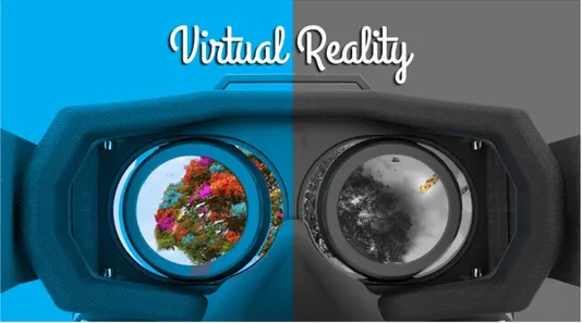
“Virtual reality is the use of computer technology to create the effect of an interactive 3D world in which the objects have a sense of spatial presence. The primary difference between conventional 3D computer graphics and VR is that in Virtual Reality we are working with things instead of pictures of things [Bryson, 1994a]”.
Virtual Reality (VR) can thus be defined as a highly immersive simulation in a three-dimensional space, with which it is possible to interact dynamically. The most important features for a virtual reality system are different:
- Visualization: visual experience is the main component of any Virtual Reality system, it is possible to see the world around itself and the elements that make it up. - Rendering System: To make the vision stereoscopic and
not to run into Motion Sickness, the visualization system must generate at least 30 frames per second for each eye (minimum frame rate) with a performance that normally attesting around 60 frames per second for each eye (optimal frame rate) to eliminate almost completely the malaise from Motion Sickness.
- Tracking system: One of the main aspects of virtual worlds is spatialization, or rather the ability of the virtual world to adapt in real time to the user who is visiting it, and giving it the opportunity to be explored physically.
Chapter 1 - Virtual Reality
JACOPO BALDINI 9
- Interaction: A virtual environment cannot be defined as such without an interaction metaphor, that is, a way of interacting between the user and the environment.
The interaction methods are many and range from the simplest use of external devices, to the use of natural user interfaces. The following items are the essential elements for the definition and creation of a virtual world, which may be more or less immersive on the basis of several factors:
- Sound: Sound plays a very important component in a virtual environment, both in terms of sensation of immersion and immediacy in use, and from the point of view of action feedback.
- Sensations involved: Any sense involved increases the immersion of the user, it is possible to make olfactory perceptions through essences or taste through appropriate tools.
Chapter 1 - Virtual Reality
JACOPO BALDINI 10
Chapter 2 - Devices for Virtual Reality
JACOPO BALDINI 11
Chapter 2 - Devices for Virtual Reality
Devices for the use of virtual reality in science are mainly two3:
- Fully Immersive Virtual Wall and Panoramic Projection VR Systems
- Head Mounted Displays
One of the most complex systems of projection by immersion systems is CAVE (Cave Automatic Virtual Environment), developed at the University of Illinois in Chicago, a virtual reality system with up to 6 viewing plans (right, left, front, back, ceiling and floor) fixed orthogonal. 3D images are projected onto the walls and ceiling of the room to wrap the user in the virtual world. Sound spatialization combined with VR input or Gesture Recognition combines a significant degree of immersion. Throughout the years and with the advance of technology, CAVE systems (Figure 2.1) have gone from being formed by several multi-processor and multi-gpu machines coupled in parallel with single computers capable of handling all screens (new GPUs).
Chapter 2 - Devices for Virtual Reality
JACOPO BALDINI 12
Figure 2.1: Cave Automatic Virtual Environmet (CAVE) at Dreamslab
There are also other simpler projection devices such as Panoramic Displays or Virtual Walls, which consist of a large flat or curved projection wall that can project in high definition; this kind of system is useful when the user is stationary and does not need to have a complete view but only a part of the field of view (eg. driving simulator or flight). One of the benefits of projection based immersion systems is the ability to use multi-user, one or more people can enter a quarry in and enjoy the experience without any limitations.
A Head Mounted Display is a visualization system that uses a screen pad with two screens that provide stereoscopic vision (one per eye or a single screen divided into two) with integrated head tracking, gyroscope and accelerometer systems that can totally immerse the user in the virtual world, completely extinguishing it entirely from the real context.
Chapter 2 - Devices for Virtual Reality
JACOPO BALDINI 13
When talking about a Head Mounted Display (Figure 2.2), this falls into "personal" display systems, which can be used by one user at a time. In fact, this type of system differs from the projection systems listed above which are single-user devices, but they have the ability to dial within applications through network systems (multi-user experience shared in the same virtual space).
Chapter 3 - Virtual Reality and Augmented Reality for Scientific Visualization
JACOPO BALDINI 14
Chapter 3 - Virtual Reality and Augmented
Reality for Scientific Visualization
Virtual Reality is an essential tool for the interpretation of scientific data. Visual representation makes it easier to understand and study the context. This type of representation can be "enhanced" through metadata and complex analysis systems within the various RV applications.
Simulation and 3D visualization of a given context allows the researcher to create hypotheses and directly test the results in the virtual world, whether by applying the hypothesis to an already existing concept or system or by creating a visualization system -ad hoc on its own hypothesis.
One of the greatest potentialities of the graphics computer coupled with Virtual Reality is the ability to change simulation parameters in real time, so you can see the different results in a clear and fast way.
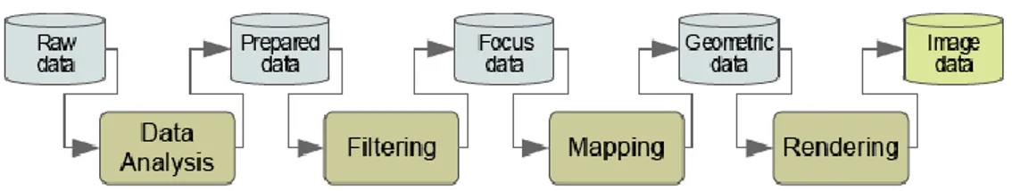
The display process can be described as a sequence of processes [Haber & McNabb, 1990], the visualization pipeline (Figure 3.1):
- Data Analysis: Data is prepared for visualization (eg, by applying a smoothing filter, interpolating missing values or correcting erroneous measurements) - usually computer-centered, little or no user interaction.
- Filtering: Selection of data portions to be visualized - usually user-centered.
- Mapping: focus data are mapped to geometric primitives (e.g., points, lines) and their attributes (e.g., color,
Chapter 3 - Virtual Reality and Augmented Reality for Scientific Visualization
JACOPO BALDINI 15
position, size); most critical step for achieving Expressiveness and Effectiveness.
- Rendering: geometric data are transformed to image data.
Figure 3.1: The visualization pipeline describes the (step-wise) process of creating visual representations from memory stored data.
Chapter 4 - Virtual Reality in Archeology
JACOPO BALDINI 16
Chapter 4 - Virtual Reality in Archeology
Virtual environments and 3D visualization introduced a new element in the analysis of archaeological data, allowing the researcher to observe and perceive the information more naturally. The reconstructive hypothesis of an archaeological site, of an object in particular, or even the 3D representation of a physical magnitude, are examples of how a graphic representation can help in understanding the data itself (Figure 4.1). The use of archaeological data is not just a visual act, but the fundamental element is to allow the researcher to understand and manipulate, to test hypotheses and to seek meaningful results, and it is at this point that the method of interaction becomes fundamental; with the current human-computer interface systems it becomes intuitive, functional and simple, allowing a more natural approach .
Chapter 4 - Virtual Reality in Archeology
JACOPO BALDINI 17
Virtual Reality offers advanced visualization and manipulation of datas applicable to archeology.
While up to now the approach has been much more oriented towards digital archiving of archaeological data, then on non-interactive 3d reconstruction, we are now getting closer to the goals that can be achieved with VR in archeology.
Especially in the last few years, there has been a clear improvement in Virtual Reality technologies, including the mass advent of these, such as 3D tv, 3D cinema, HMD, etc .. For this reason, the worlds of Cultural Heritage and VR have often been in contact with highly advanced research projects. These new tools allow the user to view and manipulate interactive graphic data, providing a valuable help to understanding and using the data itself.
We currently have several technologies for realizing reconstructions and more or less immersive applications such as C.A.V.E (Cave Automatic Virtual Environment), Head Mounted Display (HMD) and Natural User Interfaces (NUI) systems.
The applications of the new technologies are varied, but the difficulty is to find the most suitable tool for the type of task we want to accomplish; this difficulty leads to various types of studies on the interfaces to make the best use of the tools available.
When you create a virtual environment it’s essential to provide the most complete and immersive experience; to do this, it’s
Chapter 4 - Virtual Reality in Archeology
JACOPO BALDINI 18
necessary to match the NUI (Natural User Interface) to devices like HMD and CAVE.
These interfaces, constantly evolving (some examples may be: Leap Motion, Kinect, visual tracking, MYO etc ...) are a valuable tool for using VR applications, by replacing standard and intuitive interfaces for those who are not a regular user like Joypad, Joystick, Wand etc ..
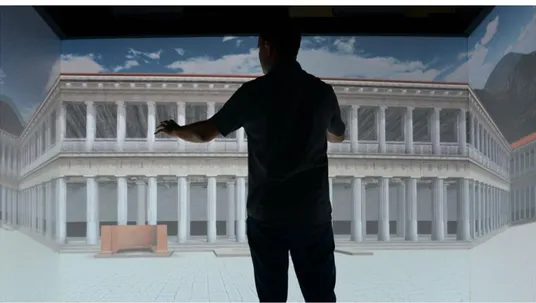
Virtual Reality is widely used for divulging applications within museums or exhibitions (Figure 4.2).
By increasing the computational capacity of new and cheaper personal computers, more realistic reconstructions can be achieved by using highly immersive systems such as HMDs (perfect for the outreach because even if mono-user these devices allow more portability that other VR systems do not have), which are designed to be applied to Videogames Engines such as Unreal Engine and Unity, enabling easy integration between 3D representations created with these Software and HMDs.
Chapter 4 - Virtual Reality in Archeology
JACOPO BALDINI 19
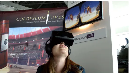
Figure 4.2: Colosseum Virtual Reality Exhibit at the Canadian War Museum
RV applications can be fundamentally of two types; the first one is a kind of virtual tour, the user is not free to move within the virtual environment but is driven inside it automatically or semi-automatically along pre-set binaries, a unique time for each user is set in the automated system, while in the semi-automatic one the user can take the time he or she wants to take advantage of (e.g. going back and forth in the presentation).
The second type of fruition of the virtual environment is instead the free visit, that gives the user the opportunity to move within the reconstruction in a totally autonomous way. Both methods are effective, and the choice is strictly related to the type of application and to reference target. An automated or semi-automatic application is easily accessed by less experienced users and leads the user to focus more on the
Chapter 4 - Virtual Reality in Archeology
JACOPO BALDINI 20
content that they want to convey, while a free application instead brings more freedom to the user and provides more interactive elements, but is not easy to use for inexperienced users and results in less concentration on content.
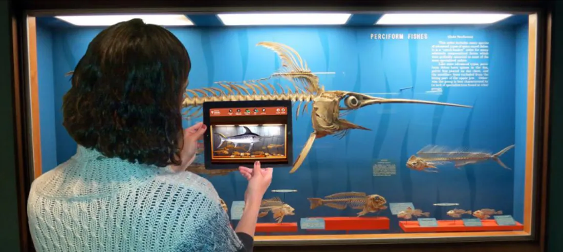
Another interesting tool in this field is the use of the Augmented Reality, which allows to re-build artworks on-site using smartphones or tablets, thus integrating excavation visits, museums and study sites with explanatory multimedia elements (Figure 4.3). Some examples may be a visit to a museum where, as an additional content, framing a statue can provide additional contextual information such as note points, material info, and sculptor, or on a broken vessel, providing a careful virtual reconstruction of the workpiece missing.
Figure 4.3: Augmented Reality Application at Smithsonian National Museum of Natural History
Chapter 4 - Virtual Reality in Archeology
JACOPO BALDINI 21
The main advantage of Augmented Reality over VR is the portability of the application and the possibility of use through a tablet or smartphone in situ (let’s think of a reconstruction of a city like Pompeii, which can be visited with a tablet allowing us to see how it was at its time).
Chapter 5 - Chemistry in cultural heritage
JACOPO BALDINI 22
Chapter 5 - Chemistry in cultural heritage
“Atoms and molecules do not seem to have much to do with art and humanistic cultural expressions. Actually, even during the primeval period of pictorial art, the choice of pigments for Etruscan and Roman mural paintings, for example, was made based on the properties of raw materials coming from natural deposits. This selection, often unconsciously of a chemical nature, was refined during the Renaissance: Raffaello, Leonardo, Piero della Francesca, Masaccio are among the main creators of new pictorial techniques obtained by mixing natural pigments with organic binders - such as egg , glue and casein. Nowdays, chemistry can go even further, offering sophisticated techniques to study the basic properties of materials that constitute a work of art and its state of degradation. At the same timechemistry can contribute to syntethize innovative products for restoration. It is a fascinating as indispensable role to preserving the historical and artistic heritage of cultural heritage. Yet, despite the fact that atoms and molecules are the primary constituents of art and the mechanisms that regulate their activities support their conservation, even in this case the contribution of chemistry goes into the background” (Campanella 2011).
The topics of interest in the chemistry applied to cultural heritage are different, as for istance:
Chapter 5 - Chemistry in cultural heritage
JACOPO BALDINI 23
- the chemical-physical processes given by time and deterioration, which affect affect the artwork (eg oxidation processes, humidity, acid or base agents, etc.), providing a great deal of historical / artistic value information that can be used for restoration and conservation.
Starting from the importance of chemical analysis on materials, the need to have one tool for displaying and comparing chemical data within cultural heritage and archeology fields is growing (Fantacci 2010).
Chapter 6 - State of the art
JACOPO BALDINI 24
Chapter 6 - State of the art
The limits of the applications so far developed by the team of the SMART/DreamsLab in the field of Digital Humanities, and in particular in the field of archaeological research, are mainly due to the lack of the interaction modalities between the data visualisation phase within the virtual environment and the query and interrogation of the database were the excavation data are collected.
In fact, this is a critical issue for many of the projects of Virtual- and Cyber-Archaeology. It basically originates from the unavoidable difficulties in the creation of an articulated system allowing for the rapid and real-time consultation of different kinds of data during the Virtual and Cyber experience.
This is the case of Segesta and the reconstruction of the late-hellenistic agora (public square) of the Sicilian city (Fig. 6.1). The project of reconstruction and virtual interaction within a virtual environment has been developed since 2012, due to a synergic collaboration between the DreamsLab and the LSA (now SAET) of the Scuola Normale Superiore, together with the LaDiRe of Pisa University. Without doubt, it represents an extraordinarily important and successful project regarding the visualisation of data and 3D models derived from the archaeological practice within a virtual interactive environment (Olivito, Taccola, Albetini 2014 e Olivito, Taccola, Albertini 2015).
Chapter 6 - State of the art
JACOPO BALDINI 25
Nevertheless, due to problems mainly originating from the lack of an ‘archaeological’ database to examine while operating in the virtual environment, the Segesta project has not been able to fully overcome the concept of ‘reconstruction’ (Clark 2010). A major obstacle was in fact represented by the use of a database software (Filemaker) during the archaeological data collection phase. Indeed, this specific software does not allow for an easy and complete interaction within the virtual environment, so that the archaeological database (Mnemosys) was substantially not available for a completely immersive interaction.
Figure 6.1: Agora of Segesta Reconstruction, layers of excavation
In order to avoid the complete recreation of a new database, allowing for the immersive interaction, a quite brilliant
Chapter 6 - State of the art
JACOPO BALDINI 26
solution to this problem has been developed and still represent a very meaningful step forward in the archaeological practice, especially due to the importance of the case study, that is the agora of Segesta.
Indeed, since May 2014 photogrammetric acquisitions of all the stratigraphic layers investigated in a crucial area of the archaeological site (the central area of the ancient public square) have been pursued. This made it possible to achieve the creation of several 3D models, not only of the different investigated layers, but also of single objects and important finds (e.g. a lion’s head protome dripstone discovered during the excavation of one of the layers testifying the collapse of the huge portico (stoa) surrounding the agora; a Swabian oven). These models were visualisable the virtual environment as isolated items composing the final reconstruction of this area of the agora. Furthermore, while interacting with the models within the virtual environment, it was possible to look up the corresponding paper recording sheets using a tablet in order to access the database stored on a dedicated server.
It is easy to understand how the distance between the visualisation of the models and the interrogation of the corresponding data and metadata constitutes a problematic issue for the correct formulation of new hypothesis or the correction of older ones: i.e. for the whole interpretative process.
Thus, from a theoretical point of view the most urgent and important element is to pursue the realization of a new
Chapter 6 - State of the art
JACOPO BALDINI 27
investigation tool allowing for the real-time visualisation of 3D models and the access to an oped-data repository. The using of adjective implies the necessity to create a database always available for updates, corrections, enhancements deriving from the archaeological research, both on field or in archives and museums.
Such an application will certainly allow archaeologists to pursue the actual passage from the concept of static reconstruction to that of dynamic simulation (Clark 2010). Last but not least, the application considered the necessity to have different levels of visualisation for the models, in which the present state of conservation of the archaeological datum could always be verified.
In this regard, the research has to focus mainly on the creation of different layers, easy to be prompted and making it possible to suddenly switch from the actual state of conservation to the corresponding 3D model resulting from the archaeological interpretation, the final aim being the achievement of a so-called simulation slice of that very specific context/object, which means the actual aspect of that context/object in a given period of time (Clark 2010).
The archaeological practice, especially the fieldwork activity, is in itself a destructive and non-replicable operation. As a consequence, the only possibility to retrieve the original aspect of an archaeological site as it was before the excavation is to access and use as many raw data as possible among those
Chapter 6 - State of the art
JACOPO BALDINI 28
derived from the fieldwork investigation (Hodder 2000, Gattiglia 2009).
With the birth of the so-called Processual Archaeology (or New Archaeology) and the criticism of the cultural-historical approach, L.R. Binford and other processual archaeologists started to consider each cultural phenomenon as unique and unrepeatable. From this point of view, the widespread use of scientific methods and technological tools (quantitative, taxonomic, computational, and laboratory analysis) seemed to be the only way to bring Archaeology nearer to the so-called Exact Sciences. Within this theoretical frame, in the 60s and early 70s the use of computer technologies seemed to perfectly answer the need for tools allowing for the storage of the increasing amount of archaeological data acquired during the fieldwork activity.
Yet, in the following decade this trend received critiques and objections, especially due to a new generation of archaeologists advocating a new socio-hystorical approach to the study of the archaeological datum.
As a consequence, only in the very last two decades a more mature and elaborated discussion on the use of database and computational tools emerged. The main point being the need for an open access to the archaeological record, which seems in fact to be the only possible way ensuring a wider dissemination of knowledge, also beyond the borders of the academic environment.
Chapter 6 - State of the art
JACOPO BALDINI 29
As a matter of fact, the transformations in the theoretical archaeological agenda affected the use and development of tools allowing for the acquisition and management of the data.
Needless to say, it is impossible to sum up here the huge amount of experiments, attempts, and projects, which contributed to the definition of the most up-to-date best-practices.
What we would try to do, then, is to highlight the two key elements in the evolution of the concept of archaeological database.
A real turning point in this sense has been the widespread use of computer technologies in the 90s, especially in terms of applications and GIS, easy-to-use also for those scholars with few or no-experience with computer technologies.
One of the best example in this sense is that of Çatalhöyük, where I. Hodder, actually one of the leading scholars supporting the Post-Processual revolution, has indeed extensively used all the possible computational, digital and virtual technologies, contributing to end the distinction between Archaeology and Informatics (Hodder 2000, D’Andrea 2009). Unfortunately, the problem with many of the databases developed during the 90s, and also with the first issue of the Çatalhöyük one, was their closed character, that is the impossibility, for those who were not involved in the project, to access and query the data.
In fact, more recently a further step in the new dialogue between Archaeology and Informatics has been stimulated by the increasing request for open data systems, allowing for a
Chapter 6 - State of the art
JACOPO BALDINI 30
wider and more public use of the information. In this sense, a very important element is represented by the diffusion and development of WEB-GIS (2D and 3D) where all the data, both from the archives and the new fieldwork activities are available for the audience of both experts and non-experts. Indeed, nowadays the focus is more on the open character of the database than on its ontology. In this sense, the evolution in the Çatalhöyük Project, with its website (http://www.catalhoyuk.com/research), is once again of great importance and constitutes one of the most valuable examples of best practices in this field.
These and other examples are mainly based on a WEB interaction, in which there cannot be space for an immersive experience.
In fact, the ultimate challenge for such an important and meaningful attempt, is to deal with a huge amounts of data (i.e. Big Data) and to think of the possible interaction metaphors and applications allowing for the easiest and also most fruitful use of the stored data, while operating within an immersive environment.
At present, Virtual and Cybernetic applications and technologies seem to represent very promising tools in the research of suitable and productive methods of interaction with the archived data. For this reason, and on the basis of the above-mentioned considerations on the evolution of the concept of database in the archaeological practice, the present work aims at further developing and stimulate the discussion and
Chapter 6 - State of the art
JACOPO BALDINI 31
the interaction between Archaeology and Informatics, with a particular focus on Digital-, Virtual-, and Cyber-Technologies.
Chapter 7 - Case studies
JACOPO BALDINI 32
Chapter 7 - Case studies
7.1 Kaulonia Virtual Reconstruction
Abstract
One of the biggest challenges that the analysis of archaeological data in virtual reality presents is the interaction.
Within the project of 3D reconstruction of Kaulonia archaeological site in Monasterace (Italy), developers had to deal with the need to implement an interface system inside the application without using external devices, in order to facilitate archaeologists in the data consultation.
A study about a system of movement and interaction with objects in the environment was conducted to create an interface for interaction based on look.
Subsequently, a method of interaction was developed by eliminating the problem of performing gestures and removing the entire "Learning Step" by users, so that it is possible to select and deselect elements, to move around in and rotate the view directly with the movement of the head.
As for the selection of the various elements within the application, a "cursor" specially implemented allows users to interact with the interactive elements: whenever the user sets a hotspot (point of interest) a pull switch is activated.
Chapter 7 - Case studies
JACOPO BALDINI 33
Within the application, it is possible to visualize a general overview of the excavation seen from above and to view the 3D models in the same spot where they were originally found: together with them, a brief historical description that contextualizes the object can be displayed.
A continuous progress of the study is allowing to explore new frontiers of digital data analysis in archaeology.
Introduction
In the last years, Cultural Heritage and Virtual Reality worlds have been in contact many times creating positive collaboration both for academic and dissemination purposes.
With the spread of new technology to the public and not only to the researchers involved in high tech field and thanks to a more affordable cost of the new hardware, a new kind of synergy has developed between Cultural Heritage and Virtual Simulations. This synergy can improve the understanding of the data for researchers and students who will study the excavations, the findings and their context.
This paper describes the entire workflow and the approach used to experiment new kinds of interaction in virtual reality simulations for Cultural Heritage, an advanced system where experts and specialists can discuss, visualize and manage heterogeneous data in the same immersive virtual environment.
Chapter 7 - Case studies
JACOPO BALDINI 34
The Sanctuary of Punta Stilo at Kaulonia: a brief historical-archaeological framework
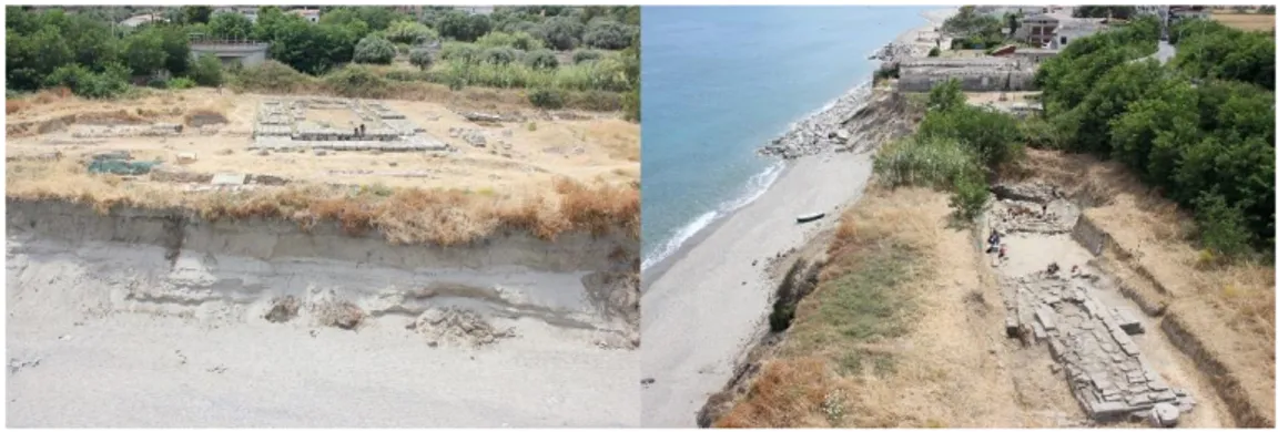
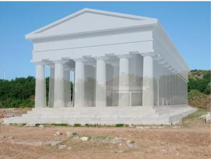
The area covered by 3D survey and modeling dedicated to development of the application described in the following paragraphs is the Sanctuary of Punta Stilo at Kaulonia (Monasterace), an ancient Greek colony founded by Achaeans people at the end of the 8th century BC in the extreme south of the Italian peninsula.
The site, on the edge of a cliff overlooking the Ionian Sea (Figure 7.1), was identified by Paolo Orsi (1915), who in 1911 brought to light the foundations of a large Doric style temple built around the years 470-460 BC and restored in the last quarter of the 5th century BC.
Figure 7.1: The Sanctuary of Punta Stilo
After years of casual excavations, a systematic resumption of archeological investigation was undertaken between 1999 and 2014 by the University of Pisa and the Scuola Normale
Chapter 7 - Case studies
JACOPO BALDINI 35
Superiore under the direction of Professor M.C. Parra, to whom (2011; 2013; 2014; 2015; 2016) the publication about new researches is due.
The investigation has allowed the sacred area to be explored in an in-depth and extensive way, in order to reach an integral view of the context, enabling firstly to define the topographical and chronological boundaries of the sacred area, which was frequented without continuity solutions from the end of the 8th to the late 4th century BC, when the temple probably collapsed due to an earthquake and the sacred area went out of use and was destined to accommodate facilities related to the storage of goods traded through the nearby harbor.
In particular, for the previous stages to the temple edification, sealed by a thick layer of waste related to its factory, the research has brought to light the remains of monumental buildings, altars, votive installations, portion of urban walls (from which an opening it was accessed to the southern Sanctuary area), areas destined for crafts related to metalworking, as well as has allowed to determine the gods worshiped within the Sanctuary, Zeus and Aphrodite.
Among the most notable discoveries, an area dedicated to the late-archaic votive offerings, characterized by the presence of several cippus fixed in the ground (the largest of them with a dedicatory inscription) and a deposition of bronze weapons, composed of two anatomical schisters and a chalcedon helmet dedicated to Zeus. An outstanding discovery is represented by a small bronze table found not far away, known as Tabula
Chapter 7 - Case studies
JACOPO BALDINI 36
Cauloniensis, which has returned the longest Greek-Achaean inscription of Western colonies (Ampolo, Parra, & Rosamilia, 2013).
The area on which the Sanctuary is situated, as well as a large part of the adjacent coast occupied by the ancient city, suffered severe damage between 2013 and 2014 due to a series of violent storms which caused the collapse of the cliff and the permanent loss of large portions of wall structures, especially in the southern sector of the sacred area.
3D modelling: Computer graphics
Regarding the virtual simulation of the Doric temple, computer graphics techniques have been applied, using as a basis the data and the hypothetical reconstructions known in literature, and so far, available only in hard copy (Barello, 1995).
On the one hand, the method has provided for the acquisition and the vectorization of 2D data in 1:1 scale, while on the other hand, for the direct survey of architectural elements found in the most recent excavations. From these data, it was possible to realize the virtual simulation of the sacred building thanks to simple extrusion, revolution, lofting and Boolean operations and integrate it within the 3D model of the entire Sanctuary made by UAV photogrammetric survey (Figure 7.2).
Chapter 7 - Case studies
JACOPO BALDINI 37
Figure 7.2: 3D model of the Doric temple.
3D data acqusition: Photogrammetry as a measurement and analysis tool
Photogrammetry is the science that, using passive optical sensors, allows for three- dimensional metric information of objects by interpreting and measuring photographic images (Remondino, 2014). In the cases subject of study, the photogrammetric method know as Structure from Motion was used.
With regard to the acquisition procedure, in the terrestrial photogrammetry a series of converging photos are taken by moving around the object to be detected, in order to cover all its geometry, while in the aerial photogrammetry several vertical images are acquired according to a grid pattern, which can be reinforced by a series of oblique and
Chapter 7 - Case studies
JACOPO BALDINI 38
convergent shots. In both methods, it is essential to ensure an overlap between photographs of 60-80% (Figure 7.3).
Figure 7.3: Terrestrial (left) and aerial acquisition procedure.
The software used, Agisoft PhotoScan Professional, foresees as a workflow the orientation of the images, the creation of the sparse and dense point cloud, the transformation into structured geometric model (mesh), and the generation of the photorealistic texture (Figure 7.4).
Chapter 7 - Case studies
JACOPO BALDINI 39
Finally, the 3D object is scaled and oriented by setting a known distance or by entering known coordinates (absolute or relative to a local reference system).
For the aerial survey at the sanctuary of Punta Stilo, a hexacopter UAV equipped with an SLR camera was used. Among the steps imposed by the workflow, the first and most important is the design of the flight plan. The software manages georeferenced images imported from Google Maps, on which the operator has to position the flight plan.
The flight plan can be configured in two customizable patterns, grid and circular, for a maximum of 32 waypoints per mission. In addition, it is necessary to set the speed of the drone, the flying altitude (calculated from the take-off position), the distance between the waypoints, the holding time on the waypoint, the angle of sight of the camera and the shooting mode (eg. each waypoint, or every few waypoints, or - as in our case - every few seconds).
During the flight, telemetry, position and path of the drone are displayed on the laptop in real time (Figure 7.5).
Chapter 7 - Case studies
JACOPO BALDINI 40
Figure 7.5: The position of the UAV along the waypoints, displayed in real time.
A second operation involves the positioning of GCPs (Ground Control Points), which allow the correct orientation of the model and, in case of GNSS data use, its georeferencing.
Regarding the area surveyed, approximately 5500 m2, the flight plan provided for a grid pattern, with waypoints spaced 4 m on the x axis and 16 m on the y axis and the speed of the UAV fixed at 1.2 m/s at an altitude of 12 m, while the camera was set for a shoot every 2 seconds.
So, a picture every 2.4 m, ideal for a 70% overlap between the photos according to the flight altitude (Taccola, Parra, & Ampolo 2014).
Other monuments in situ, including the archaic cippus inscribed, were acquired with SfM terrestrial surveying procedures.
Chapter 7 - Case studies
JACOPO BALDINI 41
It is appropriate to mention the acquisition procedure of bronze artifacts found in the Sanctuary. The photogrammetric survey of the bronze weapons deposit and the Tabula Cauloniensis was carried out in two phases, before and after restoration (Figure 7.6).
Figure 7.6: 3D model of the bronze weapons deposit, before (left) and after restoration.
Virtual Reality Visualization
The large amount of data resulting from the excavation study must be handled wisely, interpreted and understood. In this regard, a virtual view helps to understand the data and their context of finding, providing a valuable support for study and teaching. It’s not just making 3D models, but also integrating
Chapter 7 - Case studies
JACOPO BALDINI 42
into the whole working process the possibility to use new interactive technologies. In fact, one of the great benefits of virtual reality, is the ability to enable more natural forms of interaction, that will support archaeologists in the understanding their digital artefacts.
A very important issue will be to understand what is the best interaction. This paper indeed describes the whole design process leading to the prototype application, used by the archaeologist to access the excavation data and findings, visualized in a Head Mounted Display.
An essential element for the use of data that is provided, is how to handle them: a natural interaction means interacting without any learning step, providing a functional and invisible interface to the user that provides the various commands useful for interaction. It is important therefore that the application enables the user to fully manage real-time features such as metadata viewing, the ability to parse the objects in detail, and highlight the most important parts of the study so to improve and facilitate the learning process
The application is born with a polyvalent purpose, primarily as an aid to scholars and students to study, analyze and learn the excavation and its findings, in order to make the learning process active, a real collaborative space where the user can freely visit the area and understand the morphology and the conformation of buildings.
Another purpose of the reconstruction is the dissemination, that allow the finds to be available to the public and to provide
Chapter 7 - Case studies
JACOPO BALDINI 43
information on the objects and the historical context of the findings, providing the relative metadata.
A further important aspect not to underestimate is the conservation, since various storms destroyed a huge portion of the excavation, which can only be visualized through the 3d photogrammetric model. This digital resource is very precious and will allow for the study of the lost elements even by the new scholars who will approach them in the future (Stanish 2013).
Development of a new approach to the consultation and analysis: Oculus Rift
One of the main focus of this application is to develop a new approach for the consultation of the archaeological data, with a complex set of tools integrated in the applicaton. In the design phase, it was decided to use a head mounted display to make the excavation visualization more immersive and engaging as possible.
The first experiment was in fact based on an Oculus Rift (Head Mounted Display), without any input device. In this case, the interaction was limited because it was based only on the movement of the head.
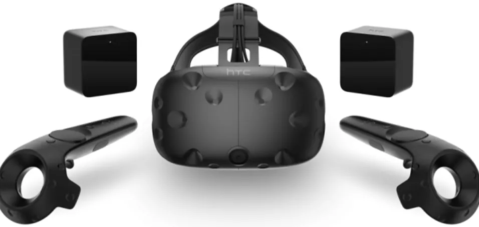
In the new phase, thanks to a new Head Mounted Display (HTC ViVe), with dedicated virtual reality controller, it has been possible to develop a new interaction.
Chapter 7 - Case studies
JACOPO BALDINI 44
The concept of the application has been to satisfy two specific requests by the archaeologists:
the ability to navigate in the 3D model of the excavation and to see the acquired findings
the ability to interact with the findings, analyzing them closely.
When the project started in 2015, we have evaluated many interaction solutions: we tried to use a OptiTrack system that does the tracking of movements, but used in combination with the helmet limited its practicality and portability; so, at first, we decided to just use a helmet for virtual reality, without any type of input device. As said before, when we started developing on Oculus, it was impossible to interact with the application without using external tools; an integrated controller for the movements came out later, so there was a need to develop a system of movement and interaction that use only the HMD sensors, without the need for additional hardware like joypad or any other similar device.
At that point, the question was: how to interact without external system?
We made an interaction study to understand, as well as how to interact, how to give feedback to the user on his actions within the virtual environment.
We thought that the interaction with eyes were the most natural thing: the user can directly observe what interests him; if his look is still for more than a specified time, the resulting action is triggered.
Chapter 7 - Case studies
JACOPO BALDINI 45
At that stage and with this type of interaction the user had a general overview of the excavation site, and once he got in the area of interest the view was locked at that point so he had the possibility to watch around his position at 360°, to select an object, to see the 3D model and the metadata. The 3d models rotated on themselves, without the possibility of interacting with them, same thing for the text, which was static.
Development of a new approach to the consultation and analysis: HTC Vive.
The next step was to evaluate the best solution to overcome the limitations of the previous system. The choice fell on "VIVE" head mounted display, which integrated the controls already tracked within the virtual environment, and a motion system that makes possible the use of the whole body (Figure 7.7). With these new opportunities, interaction was applied to archaeological data, with interesting developments.
Chapter 7 - Case studies
JACOPO BALDINI 46
Figure 7.7: HTC Vive head Mounted Display with tracking system and controllers.
Firstly, it was integrated a free exploration of the excavation: now, there is much more freedom in the movement both in sight and in the management of the 3D objects and text associated with them.
It has also been integrated to the 3D simulation of the temple, to have a direct comparison between the evidence of what is there now and what was there originally. Then an additional feature has been inserted: the ability to change the direction of light, this feature allows users to better observe the finds, and in the case of the inscriptions this is very useful.
At the start of the application, the user can view the area of the excavation from the top, then he will be teleported into the most interesting area of the site where the artifacts were found. When in place, he can look around and select the various
Chapter 7 - Case studies
JACOPO BALDINI 47
objects by pointing on each tag and clicking on the pad. Once the tag is activated, the user can observe in the left hand the finding, with the possibility of observing and manipulating it, watching the object details and shape. In the right hand, instead the text that explain the finding history will appear. In the case of objects with specific features, like the helmet, the object is automatically moved over the controller.
After seeing the discovery area and analyzing the individual finds, the user can find a menu where is possible to select the free movement mode.
In this mode, with the left hand, the user can select any point of the excavation where to be teleported, so to have a movement in the virtual space that is not too large in the real space.
The user can also reach the Doric Temple excavation site, where he can see the 3D simulation of the temple simply by activating the tags as for the previous objects (Figure 7.8). With the light feature it is possible to perceive the real dimensions and understand the importance of this structure. By changing the angle and brightness it is also possible to understand how lighting in the temple was thought.
Chapter 7 - Case studies
JACOPO BALDINI 48
Figure 7.8: Findings Metadata and model.
Conclusions
The project has reached a good point, but we are already thinking possible developing for the near future. Some interesting ideas are born by those who worked within the excavation: for example, it could be useful to expand the reconstruction, adding some other secondary findings and their metadata or to contextualize the site in its original environment.
Even more interesting would be the ability to integrate a mean to connect different helmets for collaborative visualization, making a real collaborative space for studying and teaching. The application design process forced a reflection on the interaction modalities that archaeologists could use in virtual environments. This has made possible not only to visualize the 3D models, but also to interact with them, in order to better
Chapter 7 - Case studies
JACOPO BALDINI 49
understand and use the data. For archaeologists, it is very important to have the possibility to explore excavation scenarios in addition to displaying reconstructions of buildings or important findings.
7.2 Aghia Triada in Virtual Reality
Introduction
Virtual environments and 3D visualization have introduced a new element in the process of data analysis derived from cultural assets, allowing the researcher to observe and perceive the information more naturally. The composition of a building material or structure is an example of how a graphic representation can help in the integration of the data itself and in the subsequent and eventual communication with the work. The use of scientific data is not only a visual act but it must allow the researcher to understand and manipulate information or hypothesize for meaningful results. The interaction method thus becomes fundamental: with the current human-computer interface systems it becomes intuitive, functional and simple, allowing a more natural approach. The advent of new mass technologies such as smartphones, tablets, or 3D cinemas has allowed to see and manipulate interactive graphic information even for those who practice research, providing a valuable help for understanding and using the data (Figure 7.9) .
Chapter 7 - Case studies
JACOPO BALDINI 50
Figure 7.9: Haghia Triada Virtual Reconstruction on Oculus Rift
Virtual Reality Technologies
Virtual Reality Technologies (RVs) are evolved over the last few years: methodologies are refined, computing capacity has increased, and price components have declined discreetly, allowing research centers to start developing applications or VR tools without particularly important funds.
Among these most significant tools are:
• Head mounted screens (HMD) • CAVE
• Virtual virtual glasses • Data gloves
Chapter 7 - Case studies
JACOPO BALDINI 51
• Suitable for data • Workbenches
• Natural user interface
CAVE systems, in addition to increasing computing power and lowering costs for hardware, have seen a substantial increase in the quality of manufacturers and resolution, more accurate and functional monitoring systems and new graphical machines (en-gines) and development tools, also by the explosion of consumer-oriented software.
As far as "interaction" is concerned, until recently, Data Gloves was used, a set of gloves with sensors with a real time tracking position and gesture, made for interacting with the Virtual Environments. Some examples are the Peregrine and the “5DT Gloves Data” of LLC Realities, “Data Suits” (which work like data gloves but all over the body), Joystick and Wand. These technologies are still used in some areas but are leaving room for more natural interaction methods such as infrared and tracking optics; are an example of systems like Optitrack, Kinect and Leap (also developed in various versions, greatly improved over the years). These systems, called NUIs (Natural User Interface), make fruition more intuitive and natural, especially for users who approach the VR for the early days, making the experience even more subtle.
Chapter 7 - Case studies
JACOPO BALDINI 52
Head Mounted Display
A Head Mounted Display (HMD) is usually made up of one or two pairs of semi-transparent lenses housed inside a cradle. In front of the lenses is a miniaturized display that can be LCD, AMOLED or LCoS (CRT active liquid crystals). The old HMDs, in fact, were cathode-ray tubes and are now obsolete.
The old tools for Virtual Reality were big and bulky tools, uncomfortable and difficult to understand to the user. As with technology in general, tools for virtual reality have become smaller, lighter and more affordable; Large, heavy, wrap-around HMDs have been replaced with lighter models that fall right into the front of the face.
There are HMDs that show a fully-generated computer image (CGI) and others that show a world-mediated image and add virtual elements (Augmented Reality).
History of the head mounted display and technical specifications of the Oculus Rift
In 1960, Morton Heiling created what was considered the first virtual reality headset developed for the Sensorama application, equipped with a series of sensors including a binocular system that allowed visual experience. Recently, the great innovation in the HMDs was the Oculus Rift, which in addition to having a higher resolution than the older models,
Chapter 7 - Case studies
JACOPO BALDINI 53
mounts a gyroscope, an accelerometer, and a positional optic tracker outside, at a much lower price (Table 7.1).
The table below shows the specifications of the HMD used to develop the application:
Display OLED Resolution 960 x 1080p Display Dimension 5,6” Sensors Accelerometer, Gyroscope, Magnetometer
External Sensors Camera Motion Tracking 1000 Hz Field of view 110 degree
Connectivity HDMI, DVI e USB
Table 7.1: specifications of the HMD used to develop the application
Implementation
The Haghia Triada site, the subject of this application with Head Mounted Display, was originally rebuilt by DreamsLab at the CHNT 18 conference (2013). The user could visit the
Chapter 7 - Case studies
JACOPO BALDINI 54
reconstruction of the archaeological site in various ways; starting from an outside view of the structure, including landscape, then entering the interior rooms. Originally, the application was designed for desktop use, which is also available on the web through a Web Player (Albertini 2014). The application is developed with Unity Game Engine, a graphics engine particularly suitable for Virtual Reality and with great community support.
The interior rooms have been rebuilt virtually, both for the architectural part and for the objects found inside, trying to keep as close as possible to the "real" data; administrative documents (on which a 3D acquisition was made) were placed at the excavation points. In some points of interest it was possible to obtain textual and photographic metadata together with the 3D analysis of the acquired artefacts (Figure 7.10).
Interaction
Initially, interaction was implemented through mouse and keyboard. With the mouse movement you could rotate the line of view on the X and Y axis and the left click was used to select objects; through the keyboard, the directional arrows were used for the user's movement within the reconstruction.
Chapter 7 - Case studies
JACOPO BALDINI 55
Figure 7.10: Analysis of a Cretula with text alongside
With the implementation of Oculus Rift, it was necessary to rethink the interaction within virtual environment, as the approach to application changes radically. Thanks to HMD, the immersion and the sense of involvement increase, thus providing a stronger and more cognitive experience. As for the motion and interaction device, the mouse and keyboard have been replaced with a joypad, much more suitable for use with HMD than the previously used tools, which have a learning step for the user and the inability to see the keys that are pressed by wearing the HMD. Through the joypad the movement is now handled through the two analogs on the pad: the left adjusts the movement while the right is for navigational view.
In conclusion, it's now possible to look around 360 degrees by moving your head with integrated sensors in the HMD and the
Chapter 7 - Case studies
JACOPO BALDINI 56
interaction with objects is implemented by pressing a button that triggers the metadata (Figure 7.11).
The metadata that can be used within the application are shown on a sliding plane that stays alongside the object.
Figure 7.11: Metadata displayed on the panels inside the reconstructed scene
Future developments
The application will be implemented with additional content and metadata, where the missing rooms will be contextualized; also it will be developed a more precise reconstruction of the environment in which it was Haghia Triada, recreating the surrounding fauna and inserting the native tree species in the reconstruction.
Chapter 7 - Case studies
JACOPO BALDINI 57
As a possible implementation we are also working on the catalogs so that they can be accessed directly within the application over the various templates (as for all those that can be inserted within the reconstruction) or in a special section where to browse the catalog of the finds.
It might also be possible to integrate an interaction made with the creation of a usable interface with the movement of the look. This would replace the joypad with head movement, moving by observing points of interest and related metadata.
Conclusions
We can conclude by analyzing the developments of this new immersive application that presents the reconstruction of Haghia Triada in an innovative way. First of all archaeological contents can be visualized in a more immediate and comprehensible way. With these new approaches, the various data can be explored not through a screen, but directly immersed in the reconstructed context, a factor that makes understanding closer to our perceptual sensitivity. Of course, all this is made possible by the ever-developing technologies that have allowed more and more to implement the full support of reconstruction and its ways of fruition. Currently Haghia Triada's site is visible directly within MUSINT.
Chapter 7 - Case studies
JACOPO BALDINI 58
7.3
Praedia of Iulia Felix
This new approach, obviously deriving from the previous experiences of the Segesta project, will has been tested on a very interesting case study, that is a room (the atrium 24) of a Pompeian building, the so-called Praedia of Iulia Felix (on the Praedia see Olivito 2013).
The Bourbon excavations in the area of the Praedia started in 1750, discovering a huge complex in which private areas and public sectors organised around a big central garden seem to be strictly connected with one another. The question of the main function of the Praedia is still open, as well as the personal background of the owner, Iulia, and her family. What seems to be clear is that in the final phase of the city (i.e. before 79 A.D) the Praedia was a very important building, furnished with an elegant and still functioning bath complex, and with several rooms and spaces to be rented to people who had quite a high social status.
As far as this project is concerned, it is fundamental to state that it aims at creating a system also exportable in other contexts, and in particular in the other rooms and spaces composing this Pompeian building which in the near future will be the object of a more accurate archaeological and historical research. Besides, the specifici case of study has been selected for the very multifaceted nature of data available for its study, together with the several interesting problems concerning the history of the research, the conservation state of the site, the reconstruction of wall-paintings and sculptures and,
Chapter 7 - Case studies
JACOPO BALDINI 59
eventually, the likely future acquisitions in the archives of the Museo Archeologico Nazionale di Napoli and the Parco Archeologico di Pompei.
Furthermore, it is of great importance to stress how the project originated and was developed in a very synergic scientific environment, in which experts in different field operated: on the one hand, archaeologists (Riccardo Olivito, SMART of the Scuola Normale Superiore) who contributed to the acquisition of data and metadata to be filed in the repository and contributed to the creation of the application, expressing requests and noticing doubts and weaknesses so as to achieve a final product responding to the the very needs of an archaeological and art-historical research; on the other hand, experts of Digital- and Virtual-Technologies who discussed, investigated, and actually developed the application, not only following the requests by the archaeologist, but also actively contributing to open new possible paths for future developments, originally not taken into consideration by the archaeologists.
This is a very meaningful issue. The interaction and synergic collaboration between scientists with a different cultural backgrounds is crucial to the successful outcome of research projects in which more traditional approaches of the archaeological practice and technological innovations aim at enhancing the historical knowledge. Indeed, too often in recent years some archaeologists thought of avoiding the dialogue or even the technical expertise of Digital-Technologies experts in the attempt to pursue the reconstruction of archaeological
Chapter 7 - Case studies
JACOPO BALDINI 60
contexts, monuments and objects. This is the case for several examples of Virtual Archaeology projects developed between the end of the 90s and the first decade of the new millennium. Although highly impressive for what concerns the visual aspects, this trend showed all its weakness from a scientific point of view. As noticed by Forte (Forte 2014), Virtual Archaeology mainly focused on graphic and visual issues. As a result, it was substantially unable to develop an articulated cybernetic system within actual tridimensional environments (Forte 2010).
Thus, as far as the present project is concerned, the goal of the first phase of development and test is to create a tool allowing for the query, interaction and modification of the traditional reconstruction of the atrium 24 (Figure 7.12) while interacting in an immersive virtual environment.
Chapter 7 - Case studies
JACOPO BALDINI 61
In this sense, a good example of the aims of the project is represented by the so-called ‘forum frieze’ (Olivito 2013).
As already mentioned, the Bourbon excavations in the area of the Praedia started in 1750. Together with the reports on the field activities and the main discoveries - often simple lists of findings - the field director K. Weber drew up some plans (in which every room was associated to a progressive number and to the list of findings discovered inside the room) clearly
demonstrating that the remains of the ‘forum frieze’ were brought to light in the atrium 24. Besides, this provenance is definitively confirmed by two fragments still in situ, showing also the actual position of the frieze in the vertical development of the wall decoration (Figure 7.13).
Chapter 7 - Case studies
JACOPO BALDINI 62
Soon after their discovery, the paintings were listed and detached, unfortunately not in a totally safe manner due to the superficial techniques used in the detachment operations.
Thus, as often is the case of Pompeian paintings, at present the main problem in studying this extraordinary document is the reconstruction of the original unitarity of the fragments and the connection between the frieze and the room where it was arranged. Furthermore, it is still difficult to even try to reconstruct the original sequence with which the fragments were displayed on the walls of the atrium (Figure 7.14).
Figure 7.14: Fragment
Obviously, such a consideration has deeply affected the correct visualisation of the frieze and eventually its historical reading. In order to try to solve this problem, a new tools has been developed allowing archaeologists to suggest a new reconstruction of the atrium (and its painted decoration) while operating within the virtual environment.