The International Archives of the Photogrammetry, Remote Sensing and
Spatial Information Sciences
» Guidelines for Authors (Orange Book)
» Review Process for ISPRS Archives
» Search within The International Archives of the Photogrammetry, Remote Sensing and Spatial Information Sciences
» Title and Author Search (2011 and newer)
» ISPRS Ethics Code for Publications
The International Archives of the Photogrammetry, Remote Sensing and Spatial Information Sciences
(ISPRS Archives) is the series of peer-reviewed
proceedings published by the International Society of Photogrammetry and Remote Sensing (ISPRS). In the early years of the Society,
Archive
Volumes
were published independent of Congress or Technical Commission Symposia.
Since Volume XXXII-3/W14, 1999, the Archives are open access publications, they are published under the Creative Common Attribution 3.0 (4.0
since June 2017) License, see
publications.copernicus.org/for_authors/license_and_copyright.html
for details.
The publication costs for each Archives volume are settled through the corresponding conference. Therefore, authors do not have to pay article
processing charges.
The Archives are listed in the ISI Conference Proceedings Citation Index (CPCI) of the Web of Science, SCOPUS, the E/I Compendex, and the
Directory of Open Access Journals (DOAJ).
For decades the physical repository of the archive was hosted by ITC, University of Twente in the Netherlands. ISPRS gratefully
acknowledges this support. In 2014 the repository was moved to the Technical Information Library (TIB) at Leibniz Universität Hannover,
and is now gradually being made available to the public, as all volumes are being digitised and integrated into this web interface. TIB
performs this task as a service to the Society and the spatial science community. ISPRS is greatly indebted to TIB for this kind o er.
The following table contains a list of all the ISPRS Archives.
Year Event/Title Date / Place Volume Type
2020 ISPRS TC IV
Gi4DM 2020 – 13th GeoInformation for Disaster Management conference
30 Nov - 4 Dec on-line, Sydney,
Australia
XLIV-3/W1-2020 digital
2020 ISPRS TC IV, ISPRS WG IV/1
5th International Conference on Smart City Applications on-line,7-8 Oct
Safranbolu, Turkey
XLIV-4/W3-2020 digital
2020 ISPRS TC IV
5th International Conference on Smart Data and Smart Cities 30 Sep - 2 OctNice, France XLIV-4/W2-2020 digital
2020 HERITAGE2020 (3DPast | RISK-Terra)
International Conference on Vernacular Architecture in World Heritage Sites. Risks and New Technologies
9-12 Sep on-line, Valencia, Spain
XLIV-M-1-2020 digital
2020 ISPRS TC IV
3rd BIM/GIS Integration Workshop and 15th 3D GeoInfo Conference 2020
7-11 Sep London, UK
XLIV-4/W1-2020 digital
2020
XXIV ISPRS Congress, 2020 edition, Commission I
31 Aug - 2 Sep on-line, Nice, France
XLIII-B1-2020 digital
XXIV ISPRS Congress, 2020 edition, Commission II XLIII-B2-2020 digital
XXIV ISPRS Congress, 2020 edition, Commission III XLIII-B3-2020 digital
XXIV ISPRS Congress, 2020 edition, Commission IV XLIII-B4-2020 digital
XXIV ISPRS Congress, 2020 edition, Commission V and Youth Forum XLIII-B5-2020 digital
2020 ASPRS 2020
ASPRS 2020 Annual Conference Virtual Technical Program
22-26 Jun on-line, USA
XLIV-M-2-2020 digital
2020 ISPRS WG III/10
2020 IEEE Latin American GRSS & ISPRS Remote Sensing Conference (LAGIRS 2020)
22-26 Mar Santiago, Chile
XLII-3/W12-2020 digital
2019 ISPRS WG V/7 & WG IV/6
International Workshop on “Capacity Building and Education Outreach in Advance Geospatial Technologies and Land Management”
10-11 Dec
Dhulikhel, Nepal XLII-5/W3 digital
2019 ISPRS TC II
Optical 3D Metrology Strasbourg,2-3 Dec
France
XLII-2/W18 digital
2019 ISPRS TC II
6th International Workshop LowCost 3D – Sensors, Algorithms, Applications
2-3 Dec Strasbourg,
France
XLII-2/W17 digital
2019 ISPRS WG IV/4 & IC WG IV/III
ISPRS and GEO Workshop on Geospatially-enabled SDGs Monitoring for the 2030 Agenda
19-20 Nov
Changsha, China XLII-4/W20 digital
2019 ISPRS WG III/5
International Conference on Geomatics in the Big Data Era (ICGBD 2019) Guilin, Guangxi,15-17 Nov
China
XLII-3/W10 digital
2019 ISPRS TC V
PhilGEOS x GeoAdvances 2019 “Geomatics and Data Science: Towards Adaptive Management in a Changing World”
14-15 Nov Manila, Philippines
XLII-4/W19 digital
2019 ISPRS TC III
Joint meeting of the 21st William T. Pecora Memorial Remote Sensing Symposium (Pecora 21) and the 38th International Symposium on Remote
Sensing of Environment (ISRSE 38) "Earth Observation and Continuous Monitoring of Our Changing Planet: From Sensors to Decisions"
6-11 Nov Baltimore, Maryland, USA
XLII-3/W11 digital
2019 2019 ISPRS Workshop on Remote Sensing and Synergic Analysis on
Atmospheric Environment (RSAE) Nanjing, China25-27 Oct XLII-3/W9 digital
2019 ISPRS WG IV/3, WG I/8 & WG II/4
ISPRS International GeoSpatial Conference 2019, Joint Conferences of 5th Sensors and Models in Photogrammetry and Remote Sensing (SMPR) and
3rd Geospatial Information Research (GI Research)
12-14 Oct
Karaj, Iran XLII-4/W18 digital
2019 4th International Conference on
Smart Data and Smart Cities Kuala Lumpur,1-3 Oct
Malaysia
XLII-4/W17 digital
2019 ISPRS WG IV/I
6th International Conference on
Geomatics and Geospatial Technology (GGT 2019)
1-3 Oct Kuala Lumpur,
Malaysia
XLII-4/W16 digital
2019 ISPRS WG IV/10
14th 3D GeoInfo Conference 2019 24-27 SepSingapore XLII-4/W15 digital
2019 ISPRS WG V/7
Measurement, Visualisation and Processing in BIM for Design and Construction Management
24-25 Sep Prague, Czech
Republic
XLII-5/W2 digital
2019 ISPRS ICWG II/III
PIA19+MRSS19
Photogrammetric Image Analysis & Munich Remote Sensing Symposium:
Joint ISPRS conference
18-20 Sep Munich, Germany
XLII-2/W16 digital
2019 ISPRS TC I & WG I/10
Workshop on the Evaluation and Benchmarking Sensors, Systems and Geospatial Data in Photogrammetry and Remote Sensing
16-17 Sep
Warsaw, Poland XLII-1/W2 digital
2019 ICOMOS/ISPRS International Scienti c Committee
CIPA – Heritage Documentation: 50 Years: Looking Backwards - XLII-2/W14 digital
2019 ISPRS ICWG III/IVa
Gi4DM 2019
GeoInformation for Disaster Management
3-6 Sep Prague, Czech
Republic
XLII-3/W8 digital
2019 ICOMOS/ISPRS International Scienti c Committee on Heritage Documentation (CIPA)
27th CIPA International Symposium
Documenting the past for a better future
1-5 Sep
Ávila, Spain XLII-2/W15 digital
2019 ISPRS WG IV/4
FOSS4G 2019 – Academic Track Bucharest,26-30 Aug
Romania
XLII-4/W14 digital
2019 ISPRS Geospatial Week 2019 10-14 Jun
Enschede, The Netherlands
XLII-2/W13 digital
2019 ISPRS WG II/10 & WG II/5
International Workshop on
Photogrammetric and Computer Vision Techniques for Video Surveillance,
Biometrics and Biomedicine
13-15 May
Moscow, Russia XLII-2/W12 digital
2019 ISPRS WG II/8, WG III/5, WG V/1
GEORES 2019
2nd International Conference of Geomatics and Restoration
8-10 May Milan, Italy
XLII-2/W11 digital
2019 ISPRS TC II, WG II/9
Underwater 3D Recording and Modelling
A Tool for Modern Applications and CH Recording
2-3 May
Limassol, Cyprus XLII-2/W10 digital
2019 ISPRS Technical Commission III WG III/2, 10 Joint Workshop
Multidisciplinary Remote Sensing for Environmental Monitoring
Kyoto, Japan12-14 Mar XLII-3/W7 digital2019 ISPRS WG III/10 - GEOGLAM - ISRS
Joint International Workshop on
Earth Observations for Agricultural Monitoring
18-20 Feb
New Delhi, India XLII-3/W6 digital
2019 8th International Workshop 3D-ARCH
16/3/2021 ISPRS-Archives – Volume XLII-2/W9, 2019
https://www.int-arch-photogramm-remote-sens-spatial-inf-sci.net/XLII-2-W9/ 1/11 31 Jan 2019
RECONSTRUCTION OF URBAN SITES FROM PHOTOS F. Agnello
Int. Arch. Photogramm. Remote Sens. Spatial Inf. Sci., XLII-2/W9, 1–8, https://doi.org/10.5194/isprs-archives-XLII-2-W9-1-2019, 2019
31 Jan 2019
VIRTUAL REALITY FOR HISTORICAL ARCHITECTURE F. Agnello, F. Avella, and S. Agnello
Int. Arch. Photogramm. Remote Sens. Spatial Inf. Sci., XLII-2/W9, 9–16, https://doi.org/10.5194/isprs-archives-XLII-2-W9-9-2019, 2019
31 Jan 2019
THE VIRTUAL BATCAVE: A PROJECT FOR THE SAFEGUARD OF A UNESCO WHL FRAGILE ECOSYSTEM D. Aiello, A. Basso, M. T. Spena, G. D’Agostino, U. Montedoro, M. Galizia, R. Grasso, and C. Santagati
Int. Arch. Photogramm. Remote Sens. Spatial Inf. Sci., XLII-2/W9, 17–24, https://doi.org/10.5194/isprs-archives-XLII-2-W9-17-2019, 2019
31 Jan 2019
PHOTOGRAMMETRIC SURVEY WITH FISHEYE LENS FOR THE CHARACTERIZATION OF THE LA SASSA CAVE L. Alessandri, V. Baiocchi, S. Del Pizzo, M. F. Rolfo, and S. Troisi
Int. Arch. Photogramm. Remote Sens. Spatial Inf. Sci., XLII-2/W9, 25–32, https://doi.org/10.5194/isprs-archives-XLII-2-W9-25-2019, 2019
31 Jan 2019
THE SURVEY OF THE SAN FRANCESCO BRIDGE BY SANTIAGO CALATRAVA IN COSENZA, ITALY S. Artese
Int. Arch. Photogramm. Remote Sens. Spatial Inf. Sci., XLII-2/W9, 33–37, https://doi.org/10.5194/isprs-archives-XLII-2-W9-33-2019, 2019
31 Jan 2019
INTEGRATION OF SURVEYING TECHNIQUES TO DETECT THE IDEAL SHAPE OF A DOME: THE CASE OF THE ESCUELAS PÍAS CHURCH IN VALENCIA
S. Artese, J. L. Lerma, J. Aznar Molla, R. M. Sánchez, and R. Zinno
Int. Arch. Photogramm. Remote Sens. Spatial Inf. Sci., XLII-2/W9, 39–43, https://doi.org/10.5194/isprs-archives-XLII-2-W9-39-2019, 2019
31 Jan 2019
UAV PHOTOGRAMMETRY FOR CULTURAL HERITAGE PRESERVATION MODELING AND MAPPING VENETIAN WALLS OF BERGAMO
P. Azzola, A. Cardaci, G. Mirabella Roberti, and V. M. Nannei
Int. Arch. Photogramm. Remote Sens. Spatial Inf. Sci., XLII-2/W9, 45–50, https://doi.org/10.5194/isprs-archives-XLII-2-W9-45-2019, 2019
31 Jan 2019
INTEGRATED 3D SURVEY AND DIAGNOSTIC ANALYSIS FOR THE BUILDING ENGINEERING: THE FORMER KINDERGARTEN SAN FILIPPO NERI IN DALMINE
P. Azzola, A. Cardaci, and A. Versaci
Int. Arch. Photogramm. Remote Sens. Spatial Inf. Sci., XLII-2/W9, 51–56, https://doi.org/10.5194/isprs-archives-XLII-2-W9-51-2019, 2019
31 Jan 2019
HBIM FOR ARCHAEOLOGICAL SITES: FROM SFM BASED SURVEY TO ALGORITHMIC MODELING V. Bagnolo, R. Argiolas, and A. Cuccu
Int. Arch. Photogramm. Remote Sens. Spatial Inf. Sci., XLII-2/W9, 57–63, https://doi.org/10.5194/isprs-archives-XLII-2-W9-57-2019, 2019
31 Jan 2019 Volumes
Volume XLII-2/W9, 2019 | 8th International Workshop
3D-ARCH “3D Virtual Reconstruction and Visualization of
Complex Architectures”
6–8 February 2019, Bergamo, Italy Editor(s): A. Cardaci, F. Fassi, and F. Remondino Author index | Keyword index
16/3/2021 ISPRS-Archives – Volume XLII-2/W9, 2019
https://www.int-arch-photogramm-remote-sens-spatial-inf-sci.net/XLII-2-W9/ 2/11 3D DATA PROCESSING TOWARD MAINTENANCE AND CONSERVATION. THE INTEGRATED DIGITAL DOCUMENTATION
OF CASA DE VIDRO
M. Balzani, F. Maietti, and L. Rossato
Int. Arch. Photogramm. Remote Sens. Spatial Inf. Sci., XLII-2/W9, 65–72, https://doi.org/10.5194/isprs-archives-XLII-2-W9-65-2019, 2019
31 Jan 2019
A LAYERED-WEB INTERFACE BASED ON HBIM AND 360° PANORAMAS FOR HISTORICAL, MATERIAL AND GEOMETRIC ANALYSIS
F. Banfi, M. Previtali, C. Stanga, and R. Brumana
Int. Arch. Photogramm. Remote Sens. Spatial Inf. Sci., XLII-2/W9, 73–80, https://doi.org/10.5194/isprs-archives-XLII-2-W9-73-2019, 2019
31 Jan 2019
VAULT MODELING WITH NEURAL NETWORKS L. Barazzetti and M. Previtali
Int. Arch. Photogramm. Remote Sens. Spatial Inf. Sci., XLII-2/W9, 81–86, https://doi.org/10.5194/isprs-archives-XLII-2-W9-81-2019, 2019
31 Jan 2019
CONNECTING INSIDE AND OUTSIDE THROUGH 360° IMAGERY FOR CLOSE-RANGE PHOTOGRAMMETRY L. Barazzetti, M. Previtali, F. Roncoroni, and R. Valente
Int. Arch. Photogramm. Remote Sens. Spatial Inf. Sci., XLII-2/W9, 87–92, https://doi.org/10.5194/isprs-archives-XLII-2-W9-87-2019, 2019
31 Jan 2019
QUALITY ASSESSMENT OF UAV PHOTOGRAMMETRIC ARCHAEOLOGICAL SURVEY S. Barba, M. Barbarella, A. Di Benedetto, M. Fiani, and M. Limongiello
Int. Arch. Photogramm. Remote Sens. Spatial Inf. Sci., XLII-2/W9, 93–100, https://doi.org/10.5194/isprs-archives-XLII-2-W9-93-2019, 2019
31 Jan 2019
CLUSTERING OF WALL GEOMETRY FROM UNSTRUCTURED POINT CLOUDS M. Bassier and M. Vergauwen
Int. Arch. Photogramm. Remote Sens. Spatial Inf. Sci., XLII-2/W9, 101–108, https://doi.org/10.5194/isprs-archives-XLII-2-W9-101-2019, 2019
31 Jan 2019
3D STRUCTURE ANALYSIS: ARCHITECTURE AS AN EXPRESSION OF THE TIES BETWEEN GEOMETRY AND PHILOSOPHY
T. Bellone, L. Mussio, and C. Porporato
Int. Arch. Photogramm. Remote Sens. Spatial Inf. Sci., XLII-2/W9, 109–118, https://doi.org/10.5194/isprs-archives-XLII-2-W9-109-2019, 2019
31 Jan 2019
RECONSTRUCTION OF LOST ARCHITECTURAL VOLUMES BY INTEGRATION OF PHOTOGRAMMETRY FROM ARCHIVE IMAGERY WITH 3-D MODELS OF THE STATUS QUO
M. G. Bevilacqua, G. Caroti, A. Piemonte, and D. Ulivieri
Int. Arch. Photogramm. Remote Sens. Spatial Inf. Sci., XLII-2/W9, 119–125, https://doi.org/10.5194/isprs-archives-XLII-2-W9-119-2019, 2019
31 Jan 2019
PALAZZO DUCALE OF SABBIONETA ARCHITECTURAL SURVEY OF SOME DECORATED ROOMS A. Bianchi and M. Belloni
Int. Arch. Photogramm. Remote Sens. Spatial Inf. Sci., XLII-2/W9, 127–134, https://doi.org/10.5194/isprs-archives-XLII-2-W9-127-2019, 2019
31 Jan 2019
FROM THE INTEGRATED SURVEY OF HISTORIC SETTLEMENTS TO THE PATTERN BOOK WITHIN THE BIM F. Bianconi, M. Filippucci, G. Amoruso, and M. Bertinelli
Int. Arch. Photogramm. Remote Sens. Spatial Inf. Sci., XLII-2/W9, 135–142, https://doi.org/10.5194/isprs-archives-XLII-2-W9-135-2019, 2019
31 Jan 2019
IMMERSIVE WAYFINDING: VIRTUAL RECONSTRUCTION AND EYE-TRACKING FOR ORIENTATION STUDIES INSIDE COMPLEX ARCHITECTURE
F. Bianconi, M. Filippucci, and N. Felicini
Int. Arch. Photogramm. Remote Sens. Spatial Inf. Sci., XLII-2/W9, 143–150, https://doi.org/10.5194/isprs-archives-XLII-2-W9-143-2019, 2019
31 Jan 2019
EXTRACTION OF PRIMITIVES AND OBJECTS FROM HSHAPES
16/3/2021 ISPRS-Archives – Volume XLII-2/W9, 2019
https://www.int-arch-photogramm-remote-sens-spatial-inf-sci.net/XLII-2-W9/ 3/11 EXTRACTION OF PRIMITIVES AND OBJECTS FROM HSHAPES
C. Bolognesi and V. Caffi
Int. Arch. Photogramm. Remote Sens. Spatial Inf. Sci., XLII-2/W9, 151–156, https://doi.org/10.5194/isprs-archives-XLII-2-W9-151-2019, 2019
31 Jan 2019
THE “DIAGNOSTIC SURVEY”: A METHODOLOGY FOR THE KNOWLEDGE OF A COMPLEX ARCHITECTURAL PALIMPSEST
S. Bortolotto, E. Ciocchini, A. Garzulino, R. Simonelli, and F. Zangheri
Int. Arch. Photogramm. Remote Sens. Spatial Inf. Sci., XLII-2/W9, 157–163, https://doi.org/10.5194/isprs-archives-XLII-2-W9-157-2019, 2019
31 Jan 2019
A BIM APPROACH FOR THE ANALYSIS OF AN ARCHAEOLOGICAL MONUMENT A. Bosco, A. D’Andrea, M. Nuzzolo, and P. Zanfagna
Int. Arch. Photogramm. Remote Sens. Spatial Inf. Sci., XLII-2/W9, 165–172, https://doi.org/10.5194/isprs-archives-XLII-2-W9-165-2019, 2019
31 Jan 2019
INTERACTIVE ONLINE VISUALIZATION OF COMPLEX 3D GEOMETRIES A.-M. Boutsi, C. Ioannidis, and S. Soile
Int. Arch. Photogramm. Remote Sens. Spatial Inf. Sci., XLII-2/W9, 173–180, https://doi.org/10.5194/isprs-archives-XLII-2-W9-173-2019, 2019
31 Jan 2019
ACCURACY ASSESSMENT OF 3D MODELS GENERATED FROM GOOGLE STREET VIEW IMAGERY N. Bruno and R. Roncella
Int. Arch. Photogramm. Remote Sens. Spatial Inf. Sci., XLII-2/W9, 181–188, https://doi.org/10.5194/isprs-archives-XLII-2-W9-181-2019, 2019
31 Jan 2019
TOWARDS A DIGITAL ARCHAEOLOGICAL ARCHIVE: THE CASE STUDY OF THE ARTEFACTS OF THE AREA OF FORI IMPERIALI
D. Calisi and M. Molinari
Int. Arch. Photogramm. Remote Sens. Spatial Inf. Sci., XLII-2/W9, 189–196, https://doi.org/10.5194/isprs-archives-XLII-2-W9-189-2019, 2019
31 Jan 2019
REVERSE MODELING OF CULTURAL HERITAGE: PIPELINE AND BOTTLENECKS F. Camagni, S. Colaceci, and M. Russo
Int. Arch. Photogramm. Remote Sens. Spatial Inf. Sci., XLII-2/W9, 197–204, https://doi.org/10.5194/isprs-archives-XLII-2-W9-197-2019, 2019
31 Jan 2019
DIGITAL SURVEYS AND 3D RECONSTRUCTIONS FOR AUGMENTED ACCESSIBILITY OF ARCHAEOLOGICAL HERITAGE M. Campi, A. di Luggo, D. Palomba, and R. Palomba
Int. Arch. Photogramm. Remote Sens. Spatial Inf. Sci., XLII-2/W9, 205–212, https://doi.org/10.5194/isprs-archives-XLII-2-W9-205-2019, 2019
31 Jan 2019
FAST INDOOR MAPPING TO FEED AN INDOOR DB FOR BUILDING AND FACILITY MANAGEMENT S. Cantoni and G. Vassena
Int. Arch. Photogramm. Remote Sens. Spatial Inf. Sci., XLII-2/W9, 213–217, https://doi.org/10.5194/isprs-archives-XLII-2-W9-213-2019, 2019
31 Jan 2019
SCAN-TO-BIM vs 3D IDEAL MODEL HBIM: PARAMETRIC TOOLS TO STUDY DOMES GEOMETRY M. Capone and E. Lanzara
Int. Arch. Photogramm. Remote Sens. Spatial Inf. Sci., XLII-2/W9, 219–226, https://doi.org/10.5194/isprs-archives-XLII-2-W9-219-2019, 2019
31 Jan 2019
FORENSIC ENGINEERING SURVEYS WITH UAV PHOTOGRAMMETRY AND LASER SCANNING TECHNIQUES C. Cappelletti, M. Boniardi, A. Casaroli, C. I. De Gaetani, D. Passoni, and L. Pinto
Int. Arch. Photogramm. Remote Sens. Spatial Inf. Sci., XLII-2/W9, 227–234, https://doi.org/10.5194/isprs-archives-XLII-2-W9-227-2019, 2019
31 Jan 2019
THE INTEGRATED 3D SURVEY FOR PLANNED CONSERVATION: THE FORMER CHURCH AND CONVENT OF SANT'AGOSTINO IN BERGAMO
A. Cardaci, G. Mirabella Roberti, and A. Versaci
Int. Arch. Photogramm. Remote Sens. Spatial Inf. Sci., XLII-2/W9, 235–242, https://doi.org/10.5194/isprs-archives-XLII-2-W9-235-2019 https://doi.org/10.5194/isprs-archives-XLII-2-W9-235-2019
16/3/2021 ISPRS-Archives – Volume XLII-2/W9, 2019
https://www.int-arch-photogramm-remote-sens-spatial-inf-sci.net/XLII-2-W9/ 4/11 2019, 2019
31 Jan 2019
AUGMENTED EXPERIENCE TO DISSEMINATE CULTURAL HERITAGE: HOUSE OF COMMONS WINDOWS, PARLIAMENT HILL NATIONAL HISTORIC SITE (CANADA)
B. Carrión-Ruiz, S. Blanco-Pons, M. Duong, J. Chartrand, M. Li, K. Prochnau, S. Fai, and J. L. Lerma
Int. Arch. Photogramm. Remote Sens. Spatial Inf. Sci., XLII-2/W9, 243–247, https://doi.org/10.5194/isprs-archives-XLII-2-W9-243-2019, 2019
31 Jan 2019
A REVIEW OF 3D GIS FOR USE IN CREATING VIRTUAL HISTORIC DUBLIN A. Chenaux, M. Murphy, S. Pavia, S. Fai, T. Molnar, J. Cahill, S. Lenihan, and A. Corns
Int. Arch. Photogramm. Remote Sens. Spatial Inf. Sci., XLII-2/W9, 249–254, https://doi.org/10.5194/isprs-archives-XLII-2-W9-249-2019, 2019
31 Jan 2019
3D MODELLING AND VIRTUAL REALITY APPLIED TO COMPLEX ARCHITECTURES: AN APPLICATION TO HOSPITALS’ DESIGN
P. Chias, T. Abad, M. de Miguel, G. García-Rosales, and E. Echeverria
Int. Arch. Photogramm. Remote Sens. Spatial Inf. Sci., XLII-2/W9, 255–260, https://doi.org/10.5194/isprs-archives-XLII-2-W9-255-2019, 2019
31 Jan 2019
DEVELOPMENT OF VIRTUAL REALITY APPLICATION FOR CULTURAL HERITAGE VISUALIZATION FROM MULTI-SOURCE 3D DATA
K. Choromański, J. Łobodecki, K. Puchała, and W. Ostrowski
Int. Arch. Photogramm. Remote Sens. Spatial Inf. Sci., XLII-2/W9, 261–267, https://doi.org/10.5194/isprs-archives-XLII-2-W9-261-2019, 2019
31 Jan 2019
INFORMATION MODELING AND LANDSCAPE: INTERVENTION METHODOLOGY FOR READING COMPLEX SYSTEMS M. G. Cianci and M. Molinari
Int. Arch. Photogramm. Remote Sens. Spatial Inf. Sci., XLII-2/W9, 269–276, https://doi.org/10.5194/isprs-archives-XLII-2-W9-269-2019, 2019
31 Jan 2019
THE INTEGRATED SURVEY OF NARROW SPACES AND UNDERGROUND ARCHITECTURE: THE CASE STUDY OF CAMPANA CAVES BAS-RELIEFS
P. Clini, R. Nespeca, R. Angeloni, and R. Mammoli
Int. Arch. Photogramm. Remote Sens. Spatial Inf. Sci., XLII-2/W9, 277–282, https://doi.org/10.5194/isprs-archives-XLII-2-W9-277-2019, 2019
31 Jan 2019
TERRESTRIAL LASER SCANNER AND FAST CHARACTERIZATION OF SUPERFICIAL LESIONS IN ARCHITECTURAL DIAGNOSIS
A. Costa-Jover, S. Coll-Pla, J. Queral Llaberia, D. Moreno García, and A. Gas Llatge
Int. Arch. Photogramm. Remote Sens. Spatial Inf. Sci., XLII-2/W9, 283–287, https://doi.org/10.5194/isprs-archives-XLII-2-W9-283-2019, 2019
31 Jan 2019
SURVEY, STRATIGRAPHY OF THE ELEVATIONS, 3D MODELLING FOR THE KNOWLEDGE AND CONSERVATION OF ARCHAEOLOGICAL PARKS: THE CASTLE OF AVELLA
M. D’Aprile and M. Piscitelli
Int. Arch. Photogramm. Remote Sens. Spatial Inf. Sci., XLII-2/W9, 289–296, https://doi.org/10.5194/isprs-archives-XLII-2-W9-289-2019, 2019
31 Jan 2019
TO ACHIEVE REAL IMMERSION: THE 3D VIRTUAL AND PHYSICAL RECONSTRUCTION OF CAVE 3 AND CAVE 12 OF YUNGANG GROTTOES
C. Diao, Z. Li, Z. Zhang, B. Ning, and Y. He
Int. Arch. Photogramm. Remote Sens. Spatial Inf. Sci., XLII-2/W9, 297–303, https://doi.org/10.5194/isprs-archives-XLII-2-W9-297-2019, 2019
31 Jan 2019
RECREATING CULTURAL HERITAGE ENVIRONMENTS FOR VR USING PHOTOGRAMMETRY A. Dhanda, M. Reina Ortiz, A. Weigert, A. Paladini, A. Min, M. Gyi, S. Su, S. Fai, and M. Santana Quintero
Int. Arch. Photogramm. Remote Sens. Spatial Inf. Sci., XLII-2/W9, 305–310, https://doi.org/10.5194/isprs-archives-XLII-2-W9-305-2019, 2019
31 Jan 2019
THE INTEGRATED 3D SURVEY FOR UNDERGROUND ARCHAEOLOGICAL ENVIRONMENT D. Ebolese, M. Lo Brutto, and G. Dardanelli
Int. Arch. Photogramm. Remote Sens. Spatial Inf. Sci., XLII-2/W9, 311–317,
16/3/2021 ISPRS-Archives – Volume XLII-2/W9, 2019
https://www.int-arch-photogramm-remote-sens-spatial-inf-sci.net/XLII-2-W9/ 5/11 2019, 2019
31 Jan 2019
THE TOMB OF IPI: 3D DOCUMENTATION IN A MIDDLE KINGDOM THEBAN NECROPOLIS (EGYPT, 2000 BCE) E. Echeverría, F. Celis, A. Morales, and F. da Casa
Int. Arch. Photogramm. Remote Sens. Spatial Inf. Sci., XLII-2/W9, 319–324, https://doi.org/10.5194/isprs-archives-XLII-2-W9-319-2019, 2019
31 Jan 2019
REASSEMBLY OF ROCK SEGMENTS, THE CASE OF AREOPAGUS HILL V. Evgenikou, A. Georgopoulos, and M. Korres
Int. Arch. Photogramm. Remote Sens. Spatial Inf. Sci., XLII-2/W9, 325–332, https://doi.org/10.5194/isprs-archives-XLII-2-W9-325-2019, 2019
31 Jan 2019
ALEPPO - BEFORE AND AFTER G. Fangi
Int. Arch. Photogramm. Remote Sens. Spatial Inf. Sci., XLII-2/W9, 333–338, https://doi.org/10.5194/isprs-archives-XLII-2-W9-333-2019, 2019
31 Jan 2019
QUALITY FEATURES FOR THE INTEGRATION OF TERRESTRIAL AND UAV IMAGES E. M. Farella, A. Torresani, and F. Remondino
Int. Arch. Photogramm. Remote Sens. Spatial Inf. Sci., XLII-2/W9, 339–346, https://doi.org/10.5194/isprs-archives-XLII-2-W9-339-2019, 2019
31 Jan 2019
VIRTUAL TOURS FOR SMART CITIES: A COMPARATIVE PHOTOGRAMMETRIC APPROACH FOR LOCATING HOT-SPOTS IN SPHERICAL PANORAMAS
R. Feriozzi, A. Meschini, D. Rossi, and F. Sicuranza
Int. Arch. Photogramm. Remote Sens. Spatial Inf. Sci., XLII-2/W9, 347–353, https://doi.org/10.5194/isprs-archives-XLII-2-W9-347-2019, 2019
31 Jan 2019
REPRESENTATION OF SYNTHETIC SHADOWS ON 3D DIGITAL MODELS FOR THE VOLUMETRIC INTERPRETATION ON CONCAVE-CONVEX ARCHAEOLOGICAL ARTIFACTS
J. Garcia-Fernandez, L. Medeiros, and J. Pernão
Int. Arch. Photogramm. Remote Sens. Spatial Inf. Sci., XLII-2/W9, 355–359, https://doi.org/10.5194/isprs-archives-XLII-2-W9-355-2019, 2019
31 Jan 2019
RECREATE THE ANCIENT URBAN LANDSCAPE. MULTIMEDIA AND INTERACTIVE TOOLS TO IMPROVE ACCESSIBILITY AND ENHANCEMENT OF THE ARCHAEOLOGICAL HERITAGE OF MILAN
A. Garzulino and G. Zenoni
Int. Arch. Photogramm. Remote Sens. Spatial Inf. Sci., XLII-2/W9, 361–368, https://doi.org/10.5194/isprs-archives-XLII-2-W9-361-2019, 2019
31 Jan 2019
KNOWLEDGE-BASED FRAMEWORK FOR AUTOMATIC SEMANTISATION AND RECONSTRUCTION OF MILITARY ARCHITECTURE ON CITY-SCALE MODELS
A. Gros, K. Jacquot, and T. Messaoudi
Int. Arch. Photogramm. Remote Sens. Spatial Inf. Sci., XLII-2/W9, 369–375, https://doi.org/10.5194/isprs-archives-XLII-2-W9-369-2019, 2019
31 Jan 2019
INTERACTIVE IMAGE GEOLOCALIZATION IN AN IMMERSIVE WEB APPLICATION M. Harrach, A. Devaux, and M. Brédif
Int. Arch. Photogramm. Remote Sens. Spatial Inf. Sci., XLII-2/W9, 377–380, https://doi.org/10.5194/isprs-archives-XLII-2-W9-377-2019, 2019
31 Jan 2019
SEMANTIC WEB TECHNOLOGIES MEET BIM FOR ACCESSING AND UNDERSTANDING CULTURAL HERITAGE E. Iadanza, F. Maietti, A. E. Ziri, R. Di Giulio, M. Medici, F. Ferrari, P. Bonsma, and B. Turillazzi
Int. Arch. Photogramm. Remote Sens. Spatial Inf. Sci., XLII-2/W9, 381–388, https://doi.org/10.5194/isprs-archives-XLII-2-W9-381-2019, 2019
31 Jan 2019
HIGH QUALITY TEXTURE MAPPING PROCESS AIMED AT THE OPTIMIZATION OF 3D STRUCTURED LIGHT MODELS L. Inzerillo, F. Di Paola, and Y. Alogna
Int. Arch. Photogramm. Remote Sens. Spatial Inf. Sci., XLII-2/W9, 389–396, https://doi.org/10.5194/isprs-archives-XLII-2-W9-389-2019, 2019
31 Jan 2019
UAV FOR MAPPING HISTORIC BUI DINGS FROM 3D MODE ING TO BIM
16/3/2021 ISPRS-Archives – Volume XLII-2/W9, 2019
https://www.int-arch-photogramm-remote-sens-spatial-inf-sci.net/XLII-2-W9/ 6/11 UAV FOR MAPPING HISTORIC BUILDINGS: FROM 3D MODELLING TO BIM
E. Karachaliou, E. Georgiou, D. Psaltis, and E. Stylianidis
Int. Arch. Photogramm. Remote Sens. Spatial Inf. Sci., XLII-2/W9, 397–402, https://doi.org/10.5194/isprs-archives-XLII-2-W9-397-2019, 2019
31 Jan 2019
GENERATIVE ADVERSARIAL NETWORKS FOR SINGLE PHOTO 3D RECONSTRUCTION V. V. Kniaz, F. Remondino, and V. A. Knyaz
Int. Arch. Photogramm. Remote Sens. Spatial Inf. Sci., XLII-2/W9, 403–408, https://doi.org/10.5194/isprs-archives-XLII-2-W9-403-2019, 2019
31 Jan 2019
UNCERTAINTY VISUALIZATION APPROACHES FOR 3D MODELS OF CASTLES RESTITUTED FROM ARCHEOLOGICAL KNOWLEDGE
T. Landes, M. Heissler, M. Koehl, T. Benazzi, and T. Nivola
Int. Arch. Photogramm. Remote Sens. Spatial Inf. Sci., XLII-2/W9, 409–416, https://doi.org/10.5194/isprs-archives-XLII-2-W9-409-2019, 2019
31 Jan 2019
3D MODELLING AND MEDIEVAL LIGHTING RECONSTRUCTION FOR RUPESTRIAN CHURCHES P. Lassandro, M. Lepore, A. Paribeni, and M. Zonno
Int. Arch. Photogramm. Remote Sens. Spatial Inf. Sci., XLII-2/W9, 417–423, https://doi.org/10.5194/isprs-archives-XLII-2-W9-417-2019, 2019
31 Jan 2019
A COMBINED APPROACH FOR SURVEYING COMPLEX COASTAL SITES M. Liuzzo, R. Feo, S. Giuliano, and V. Pampalone
Int. Arch. Photogramm. Remote Sens. Spatial Inf. Sci., XLII-2/W9, 425–432, https://doi.org/10.5194/isprs-archives-XLII-2-W9-425-2019, 2019
31 Jan 2019
DATA MODELING FOR MUSEUM COLLECTIONS M. Lo Turco, M. Calvano, and E. C. Giovannini
Int. Arch. Photogramm. Remote Sens. Spatial Inf. Sci., XLII-2/W9, 433–440, https://doi.org/10.5194/isprs-archives-XLII-2-W9-433-2019, 2019
31 Jan 2019
3D AND 4D MODELLING IN BUILDING SITE WORKING CONTROL M. Lucarelli, E. Laurini, and P. De Berardinis
Int. Arch. Photogramm. Remote Sens. Spatial Inf. Sci., XLII-2/W9, 441–446, https://doi.org/10.5194/isprs-archives-XLII-2-W9-441-2019, 2019
31 Jan 2019
3D DIGITAL MODELS FOR A WIDESPREAD MUSEUM: THE RENON’S “BAUERNHÖFE” A. Luigini, S. Brusaporci, S. Vattano, and A. Tata
Int. Arch. Photogramm. Remote Sens. Spatial Inf. Sci., XLII-2/W9, 447–453, https://doi.org/10.5194/isprs-archives-XLII-2-W9-447-2019, 2019
31 Jan 2019
AUTOMATING THE VERIFICATION OF HERITAGE BUILDING INFORMATION MODELS CREATED FROM POINT CLOUD DATA
H. Macher, L. Chow, and S. Fai
Int. Arch. Photogramm. Remote Sens. Spatial Inf. Sci., XLII-2/W9, 455–460, https://doi.org/10.5194/isprs-archives-XLII-2-W9-455-2019, 2019
31 Jan 2019
AS-BUILT RELIABILITY IN ARCHITECTURAL HBIM MODELING P. Maiezza
Int. Arch. Photogramm. Remote Sens. Spatial Inf. Sci., XLII-2/W9, 461–466, https://doi.org/10.5194/isprs-archives-XLII-2-W9-461-2019, 2019
31 Jan 2019
THE COMPARISON OF 2D AND 3D DETECTORS FOR TLS DATA REGISTRATION – PRELIMINARY RESULTS J. S. Markiewicz, Ł. Markiewicz, and P. Foryś
Int. Arch. Photogramm. Remote Sens. Spatial Inf. Sci., XLII-2/W9, 467–472, https://doi.org/10.5194/isprs-archives-XLII-2-W9-467-2019, 2019
31 Jan 2019
3D MODELING OF GIRIFALCO FORTRESS
A. Masiero, F. Chiabrando, A. M. Lingua, B. G. Marino, F. Fissore, A. Guarnieri, and A. Vettore
Int. Arch. Photogramm. Remote Sens. Spatial Inf. Sci., XLII-2/W9, 473–478,
16/3/2021 ISPRS-Archives – Volume XLII-2/W9, 2019
https://www.int-arch-photogramm-remote-sens-spatial-inf-sci.net/XLII-2-W9/ 7/11 31 Jan 2019
PARAMETRICAL ANALYSIS AND DIGITAL FABRICATION OF THIN SHELL STRUCTURES: THE IMPACT OF CONSTRUCTION TECHNIQUE ON THE RESULTING GEOMETRY OF THE GAUSSIAN VAULTS OF ELADIO DIESTE F. C. Melachos, W. Florio, L. Rossato, and M. Balzani
Int. Arch. Photogramm. Remote Sens. Spatial Inf. Sci., XLII-2/W9, 479–485, https://doi.org/10.5194/isprs-archives-XLII-2-W9-479-2019, 2019
31 Jan 2019
DIGITAL CONTENTS FOR ENHANCING THE COMMUNICATION OF MUSEUM EXHIBITION: THE PERVIVAL PROJECT L. L. Micoli, S. Gonizzi Barsanti, G. Caruso, and G. Guidi
Int. Arch. Photogramm. Remote Sens. Spatial Inf. Sci., XLII-2/W9, 487–493, https://doi.org/10.5194/isprs-archives-XLII-2-W9-487-2019, 2019
31 Jan 2019
EXISTING-BIM: INTEGRATED SURVEY PROCEDURES FOR THE MANAGEMENT OF MODERN ARCHITECTURE S. Monaco, M. Siconolfi, and A. di Luggo
Int. Arch. Photogramm. Remote Sens. Spatial Inf. Sci., XLII-2/W9, 495–500, https://doi.org/10.5194/isprs-archives-XLII-2-W9-495-2019, 2019
31 Jan 2019
THE USE OF DIGITAL TOOLS FOR THE PRESERVATION OF ARCHITECTURAL, ARTISTIC AND CULTURAL HERITAGE, THROUGH THREE-DIMENSIONAL SCANNING AND DIGITAL MANUFACTURING
K. Moreno Gata and E. Echeverría Valiente
Int. Arch. Photogramm. Remote Sens. Spatial Inf. Sci., XLII-2/W9, 501–506, https://doi.org/10.5194/isprs-archives-XLII-2-W9-501-2019, 2019
31 Jan 2019
CAPTURE AND DOCUMENTATION: KAGA PARK C. Morganti and C. Bartolomei
Int. Arch. Photogramm. Remote Sens. Spatial Inf. Sci., XLII-2/W9, 507–514, https://doi.org/10.5194/isprs-archives-XLII-2-W9-507-2019, 2019
31 Jan 2019
HBIM AND THE 20TH CENTURY STEEL BUILDING HERITAGE – A PROCEDURE SUITABLE FOR THE CONSTRUCTION HISTORY IN ITALY
R. Morganti, A. Tosone, D. Di Donato, and M. Abita
Int. Arch. Photogramm. Remote Sens. Spatial Inf. Sci., XLII-2/W9, 515–522, https://doi.org/10.5194/isprs-archives-XLII-2-W9-515-2019, 2019
31 Jan 2019
POINT CLOUD SEGMENTATION AND SEMANTIC ANNOTATION AIDED BY GIS DATA FOR HERITAGE COMPLEXES A. Murtiyoso and P. Grussenmeyer
Int. Arch. Photogramm. Remote Sens. Spatial Inf. Sci., XLII-2/W9, 523–528, https://doi.org/10.5194/isprs-archives-XLII-2-W9-523-2019, 2019
31 Jan 2019
VIRTUAL HERITAGE FOR THE DISSEMINATION OF THE BARATTI IN 3D PROJECT G. Nicastro and P. Puma
Int. Arch. Photogramm. Remote Sens. Spatial Inf. Sci., XLII-2/W9, 529–534, https://doi.org/10.5194/isprs-archives-XLII-2-W9-529-2019, 2019
31 Jan 2019
COMPARISON WITH ACCURACY OF TERRESTRIAL LASER SCANNER BY USING POINT CLOUD ALIGNED WITH SHAPE MATCHING AND BEST FITTING METHODS
T. Ogawa and Y. Hori
Int. Arch. Photogramm. Remote Sens. Spatial Inf. Sci., XLII-2/W9, 535–541, https://doi.org/10.5194/isprs-archives-XLII-2-W9-535-2019, 2019
31 Jan 2019
3D DETECTION AND RECONSTRUCTION EXPERIMENTS IN RIVER BASINS C. Palestini and A. Basso
Int. Arch. Photogramm. Remote Sens. Spatial Inf. Sci., XLII-2/W9, 543–550, https://doi.org/10.5194/isprs-archives-XLII-2-W9-543-2019, 2019
31 Jan 2019
TOWARDS DEEP LEARNING FOR ARCHITECTURE: A MONUMENT RECOGNITION MOBILE APP V. Palma
Int. Arch. Photogramm. Remote Sens. Spatial Inf. Sci., XLII-2/W9, 551–556, https://doi.org/10.5194/isprs-archives-XLII-2-W9-551-2019, 2019
31 Jan 2019
AUGMENTED TURIN BAROQUE ATRIA: AR EXPERIENCES FOR ENHANCING CULTURAL HERITAGE V P l R S ll d M Vi li
16/3/2021 ISPRS-Archives – Volume XLII-2/W9, 2019
https://www.int-arch-photogramm-remote-sens-spatial-inf-sci.net/XLII-2-W9/ 8/11 V. Palma, R. Spallone, and M. Vitali
Int. Arch. Photogramm. Remote Sens. Spatial Inf. Sci., XLII-2/W9, 557–564, https://doi.org/10.5194/isprs-archives-XLII-2-W9-557-2019, 2019
31 Jan 2019
A FULLY AUTOMATED INCREMENTAL PHOTOGRAMMETRIC PROCESSING DEDICATED FOR COLLABORATIVE REMOTE-COMPUTING WORKFLOW
A. Pamart, F. Morlet, and L. de Luca
Int. Arch. Photogramm. Remote Sens. Spatial Inf. Sci., XLII-2/W9, 565–571, https://doi.org/10.5194/isprs-archives-XLII-2-W9-565-2019, 2019
31 Jan 2019
A COMPLETE FRAMEWORK OPERATING SPATIALLY-ORIENTED RTI IN A 3D/2D CULTURAL HERITAGE DOCUMENTATION AND ANALYSIS TOOL
A. Pamart, F. Ponchio, V. Abergel, A. Alaoui M'Darhri, M. Corsini, M. Dellepiane, F. Morlet, R. Scopigno, and L. De Luca Int. Arch. Photogramm. Remote Sens. Spatial Inf. Sci., XLII-2/W9, 573–580, https://doi.org/10.5194/isprs-archives-XLII-2-W9-573-2019, 2019
31 Jan 2019
THE VALUE OF KNOWLEDGE THROUGH H-BIM MODELS: HISTORIC DOCUMENTATION WITH A SEMANTIC APPROACH P. Parisi, M. Lo Turco, and E. C. Giovannini
Int. Arch. Photogramm. Remote Sens. Spatial Inf. Sci., XLII-2/W9, 581–588, https://doi.org/10.5194/isprs-archives-XLII-2-W9-581-2019, 2019
31 Jan 2019
INTEGRATION AND COMPARISON OF CLOSE-RANGE SFM METHODOLOGIES FOR THE ANALYSIS AND THE DEVELOPMENT OF THE HISTORICAL CITY CENTER OF BETHLEHEM
S. Parrinello and F. Picchio
Int. Arch. Photogramm. Remote Sens. Spatial Inf. Sci., XLII-2/W9, 589–595, https://doi.org/10.5194/isprs-archives-XLII-2-W9-589-2019, 2019
31 Jan 2019
VIRTUAL REALITY TO ALLOW WHEELCHAIR USERS TOURING COMPLEX ARCHAEOLOGICAL SITES IN A REALISTIC MANNER. TOWARDS THEIR ACTUAL SOCIAL INTEGRATION
E. Pérez, M. J. Merchán, S. Salamanca, and P. Merchán
Int. Arch. Photogramm. Remote Sens. Spatial Inf. Sci., XLII-2/W9, 597–604, https://doi.org/10.5194/isprs-archives-XLII-2-W9-597-2019, 2019
31 Jan 2019
GENERATION OF GIGAPIXEL ORTHOPHOTO FOR THE MAINTENANCE OF COMPLEX BUILDINGS. CHALLENGES AND LESSON LEARNT
L. Perfetti, F. Fassi, and H. Gulsan
Int. Arch. Photogramm. Remote Sens. Spatial Inf. Sci., XLII-2/W9, 605–614, https://doi.org/10.5194/isprs-archives-XLII-2-W9-605-2019, 2019
31 Jan 2019
THE REAL IN THE VIRTUAL. THE 3D MODEL IN THE CULTURAL HERITAGE SECTOR: THE TIP OF THE ICEBERG S. Pratali Maffei, E. Canevese, and T. De Gottardo
Int. Arch. Photogramm. Remote Sens. Spatial Inf. Sci., XLII-2/W9, 615–621, https://doi.org/10.5194/isprs-archives-XLII-2-W9-615-2019, 2019
31 Jan 2019
WOODEN TRUSSES RECONSTRUCTION AND ANALYSIS THROUGH PARAMETRIC 3D MODELING D. Prati, G. Zuppella, G. Mochi, L. Guardigli, and R. Gulli
Int. Arch. Photogramm. Remote Sens. Spatial Inf. Sci., XLII-2/W9, 623–629, https://doi.org/10.5194/isprs-archives-XLII-2-W9-623-2019, 2019
31 Jan 2019
AUTOMATED DETECTION AND LAYOUT REGULARIZATION OF SIMILAR FEATURES IN INDOOR POINT CLOUD M. Previtali, L. Barazzetti, and F. Roncoroni
Int. Arch. Photogramm. Remote Sens. Spatial Inf. Sci., XLII-2/W9, 631–638, https://doi.org/10.5194/isprs-archives-XLII-2-W9-631-2019, 2019
31 Jan 2019
3D CAMERAS ACQUISITIONS FOR THE DOCUMENTATION OF CULTURAL HERITAGE M. Pulcrano, S. Scandurra, G. Minin, and A. di Luggo
Int. Arch. Photogramm. Remote Sens. Spatial Inf. Sci., XLII-2/W9, 639–646, https://doi.org/10.5194/isprs-archives-XLII-2-W9-639-2019, 2019
31 Jan 2019
THE EUROPEAN RESEARCH NIGHT: NEW WAYS FOR COMMUNICATING SCIENCE WITH ICT AND VIDEOMAPPING
16/3/2021 ISPRS-Archives – Volume XLII-2/W9, 2019
https://www.int-arch-photogramm-remote-sens-spatial-inf-sci.net/XLII-2-W9/ 9/11 Int. Arch. Photogramm. Remote Sens. Spatial Inf. Sci., XLII-2/W9, 647–654,
https://doi.org/10.5194/isprs-archives-XLII-2-W9-647-2019, 2019 31 Jan 2019
CREATING, VISUALIZING AND SHARING HIGH-POLY AND MULTI-TEXTURES MODELS ON THE WEB F. Rechichi and F. Fiorillo
Int. Arch. Photogramm. Remote Sens. Spatial Inf. Sci., XLII-2/W9, 655–662, https://doi.org/10.5194/isprs-archives-XLII-2-W9-655-2019, 2019
31 Jan 2019
THE SUITABILITY OF TERRESTRIAL LASER SCANNING FOR BUILDING SURVEY AND MAPPING APPLICATIONS N. A. S. Russhakim, M. F. M. Ariff, Z. Majid, K. M. Idris, N. Darwin, M. A. Abbas, K. Zainuddin, and A. R. Yusoff
Int. Arch. Photogramm. Remote Sens. Spatial Inf. Sci., XLII-2/W9, 663–670, https://doi.org/10.5194/isprs-archives-XLII-2-W9-663-2019, 2019
31 Jan 2019
PARAMETRIC SURFACES FOR AUGMENTED ARCHITECTURE REPRESENTATION M. Russo, S. Menconero, and L. Baglioni
Int. Arch. Photogramm. Remote Sens. Spatial Inf. Sci., XLII-2/W9, 671–678, https://doi.org/10.5194/isprs-archives-XLII-2-W9-671-2019, 2019
31 Jan 2019
EVALUATING THE STRUCTURAL INTEGRITY OF THE SAINT ANTONIO BARREL VAULT IN THE FORTRESS OF ALMEIDA BY COMBINING LASER SCANNER AND LIMIT ANALYSIS
L. J. Sanchez-Aparicio, P. Rodriguez-Gonzalvez, D. Gonzalez-Aguilera, and L. F. Ramos
Int. Arch. Photogramm. Remote Sens. Spatial Inf. Sci., XLII-2/W9, 679–684, https://doi.org/10.5194/isprs-archives-XLII-2-W9-679-2019, 2019
31 Jan 2019
SEMANTIC PHOTOGRAMMETRY – BOOSTING IMAGE-BASED 3D RECONSTRUCTION WITH SEMANTIC LABELING E.-K. Stathopoulou and F. Remondino
Int. Arch. Photogramm. Remote Sens. Spatial Inf. Sci., XLII-2/W9, 685–690, https://doi.org/10.5194/isprs-archives-XLII-2-W9-685-2019, 2019
31 Jan 2019
MODELLING BUILDING COSTS FROM 3D BUILDING MODELS – ESTIMATING THE CONSTRUCTION EFFORT FROM IMAGE-BASED SURFACE MODELS OF DRY-STONE SHEPHERD SHELTERS (KRAS, SLOVENIA)
S. Štuhec, G. Verhoeven, and I. Štuhec
Int. Arch. Photogramm. Remote Sens. Spatial Inf. Sci., XLII-2/W9, 691–698, https://doi.org/10.5194/isprs-archives-XLII-2-W9-691-2019, 2019
31 Jan 2019
3D IMAGE BASED GEOMETRIC DOCUMENTATION OF A MEDIEVAL FORTRESS
S. Tapinaki, M. Skamantzari, R. Chliverou, V. Evgenikou, A. M. Konidi, E. Ioannatou, A. Mylonas, and A. Georgopoulos Int. Arch. Photogramm. Remote Sens. Spatial Inf. Sci., XLII-2/W9, 699–705, https://doi.org/10.5194/isprs-archives-XLII-2-W9-699-2019, 2019
31 Jan 2019
ACCESS AND WEB-SHARING OF 3D DIGITAL DOCUMENTATION OF ENVIRONMENTAL AND ARCHITECTURAL HERITAGE
C. Tommasi, F. Fiorillo, B. Jiménez Fernández-Palacios, and C. Achille
Int. Arch. Photogramm. Remote Sens. Spatial Inf. Sci., XLII-2/W9, 707–714, https://doi.org/10.5194/isprs-archives-XLII-2-W9-707-2019, 2019
31 Jan 2019
THE ARCHAEOLOGICAL ANALYSIS OF MASONRY FOR THE RESTORATION PROJECT IN HBIM I. Trizio, F. Savini, A. Giannangeli, R. Boccabella, and G. Petrucci
Int. Arch. Photogramm. Remote Sens. Spatial Inf. Sci., XLII-2/W9, 715–722, https://doi.org/10.5194/isprs-archives-XLII-2-W9-715-2019, 2019
31 Jan 2019
VIRTUALISING AN OTTOMAN FORTRESS – LASER SCANNING AND 3D MODELLING FOR THE DEVELOPMENT OF AN INTERACTIVE, IMMERSIVE VIRTUAL REALITY APPLICATION
F. Tschirschwitz, G. Büyüksalih, T. P. Kersten, T. Kan, G. Enc, and P. Baskaraca
Int. Arch. Photogramm. Remote Sens. Spatial Inf. Sci., XLII-2/W9, 723–729, https://doi.org/10.5194/isprs-archives-XLII-2-W9-723-2019, 2019
31 Jan 2019
CONSIDERATIONS ON THE USE OF DIGITAL TOOLS FOR DOCUMENTING ANCIENT WALL GRAFFITI R. Valente, L. Barazzetti, M. Previtali, and F. Roncoroni
Int. Arch. Photogramm. Remote Sens. Spatial Inf. Sci., XLII-2/W9, 731–737, https://doi.org/10.5194/isprs-archives-XLII-2-W9-731-2019 https://doi.org/10.5194/isprs-archives-XLII-2-W9-731-2019
16/3/2021 ISPRS-Archives – Volume XLII-2/W9, 2019
https://www.int-arch-photogramm-remote-sens-spatial-inf-sci.net/XLII-2-W9/ 10/11 2019, 2019
31 Jan 2019
A COMPARISON BETWEEN TLS AND UAV TECHNOLOGIES FOR HISTORICAL INVESTIGATION R. Valenti and E. Paternò
Int. Arch. Photogramm. Remote Sens. Spatial Inf. Sci., XLII-2/W9, 739–745, https://doi.org/10.5194/isprs-archives-XLII-2-W9-739-2019, 2019
31 Jan 2019
IMAGE RECORDING CHALLENGES FOR PHOTOGRAMMETRIC CONSTRUCTION SITE MONITORING S. Vincke, M. Bassier, and M. Vergauwen
Int. Arch. Photogramm. Remote Sens. Spatial Inf. Sci., XLII-2/W9, 747–753, https://doi.org/10.5194/isprs-archives-XLII-2-W9-747-2019, 2019
31 Jan 2019
FOVEON VS BAYER: COMPARISON OF 3D RECONSTRUCTION PERFORMANCES M. Vlachos, D. Skarlatos, and P. Bodin
Int. Arch. Photogramm. Remote Sens. Spatial Inf. Sci., XLII-2/W9, 755–761, https://doi.org/10.5194/isprs-archives-XLII-2-W9-755-2019, 2019
31 Jan 2019
THREE-DIMENSIONAL RECORDING AND PHOTOREALISTIC MODEL RECONSTRUCTION FOR VIRTUAL MUSEUM APPLICATION – AN EXPERIENCE IN MALAYSIA
O. C. Wei, Z. Majid, H. Setan, M. F. M. Ariff, K. M. Idris, N. Darwin, A. R. Yusoff, and K. Zainuddin
Int. Arch. Photogramm. Remote Sens. Spatial Inf. Sci., XLII-2/W9, 763–771, https://doi.org/10.5194/isprs-archives-XLII-2-W9-763-2019, 2019
31 Jan 2019
A REVIEW OF RECORDING TECHNOLOGIES FOR DIGITAL FABRICATION IN HERITAGE CONSERVATION A. Weigert, A. Dhanda, J. Cano, C. Bayod, S. Fai, and M. Santana Quintero
Int. Arch. Photogramm. Remote Sens. Spatial Inf. Sci., XLII-2/W9, 773–778, https://doi.org/10.5194/isprs-archives-XLII-2-W9-773-2019, 2019
31 Jan 2019
A COMPARATIVE STUDY AMONG THREE REGISTRATION ALGORITHMS: PERFORMANCE, QUALITY ASSURANCE AND ACCURACY
D. Wujanz, L. Barazzetti, M. Previtali, and M. Scaioni
Int. Arch. Photogramm. Remote Sens. Spatial Inf. Sci., XLII-2/W9, 779–786, https://doi.org/10.5194/isprs-archives-XLII-2-W9-779-2019, 2019
31 Jan 2019
3D MODELING FOR ROCK ART DOCUMENTATION USING LIGHTWEIGHT MULTISPECTRAL CAMERA K. Zainuddin, Z. Majid, M. F. M. Ariff, K. M. Idris, M. A. Abbas, and N. Darwin
Int. Arch. Photogramm. Remote Sens. Spatial Inf. Sci., XLII-2/W9, 787–793, https://doi.org/10.5194/isprs-archives-XLII-2-W9-787-2019, 2019
31 Jan 2019
MACRO PHOTOGRAMMETRY IN INVENTORY OF HISTORICAL ENGRAVINGS AT THE ROYAL CASTLE IN WARSAW D. Zawieska, J. Markiewicz, and M. Łuba
Int. Arch. Photogramm. Remote Sens. Spatial Inf. Sci., XLII-2/W9, 795–800, https://doi.org/10.5194/isprs-archives-XLII-2-W9-795-2019, 2019
31 Jan 2019
FROM SURVEY TO MODEL, AND RETURN. THE CASE OF THE PARMA BAPTISTERY A. Zerbi and S. Mikolajewska
Int. Arch. Photogramm. Remote Sens. Spatial Inf. Sci., XLII-2/W9, 801–808, https://doi.org/10.5194/isprs-archives-XLII-2-W9-801-2019, 2019 USEFUL LINKS ISPRS Archives ISPRS Annals ISPRS eBulletin Calendar 2021
16/3/2021 ISPRS-Archives - VIRTUAL TOURS FOR SMART CITIES: A COMPARATIVE PHOTOGRAMMETRIC APPROACH FOR LOCATING HOT-SPOTS IN SPHERICAL PANORAMAS
https://www.int-arch-photogramm-remote-sens-spatial-inf-sci.net/XLII-2-W9/347/2019/ 1/2
31 Jan 2019
VIRTUAL TOURS FOR SMART CITIES: A COMPARATIVE
PHOTOGRAMMETRIC APPROACH FOR LOCATING
HOT-SPOTS IN SPHERICAL PANORAMAS
R. Feriozzi, A. Meschini, D. Rossi, and F. Sicuranza
University of Camerino, School of Architecture and Design (SAAD), Ascoli Piceno, Italy
Keywords: smart city, spherical panoramas, photogrammetry, virtual tour, graphical interfaces
Abstract. The paper aims to investigate the possibilities of using the panorama-based VR to survey data related to that set of activities for planning and
management of urban areas, belonging to the Smart Cities strategies. The core of our workflow is to facilitate the visualization of the data produced by
the infrastructures of the Smart Cities. A graphical interface based on spherical panoramas, instead of complex three-dimensional could help the
user/citizen of the city to better know the operation related to control units spread in the urban area. From a methodological point of view three different
kind of spherical panorama acquisition has been tested and compared in order to identify a semi-automatic procedure for locating homologous points on
two or more spherical images starting from a point cloud obtained from the same images. The points thus identified allow to quickly identify the same
hot-spot on multiple images simultaneously. The comparison shows how all three systems have proved to be useful for the purposes of the research but only
one has proved to be reliable from a geometric point of view to identify the locators useful for the construction of the virtual tour.
How to cite. Feriozzi, R., Meschini, A., Rossi, D., and Sicuranza, F.: VIRTUAL TOURS FOR SMART CITIES: A COMPARATIVE PHOTOGRAMMETRIC
APPROACH FOR LOCATING HOT-SPOTS IN SPHERICAL PANORAMAS, Int. Arch. Photogramm. Remote Sens. Spatial Inf. Sci., XLII-2/W9, 347–353,
https://doi.org/10.5194/isprs-archives-XLII-2-W9-347-2019, 2019.
Articles
|
Volume XLII-2/W9
Int. Arch. Photogramm. Remote Sens. Spatial Inf. Sci., XLII-2/W9, 347–353, 2019 https://doi.org/10.5194/isprs-archives-XLII-2-W9-347-2019
© Author(s) 2019. This work is distributed under the Creative Commons Attribution 4.0 License.
Metrics
Related articles
Article (PDF, 1727 KB)
Download & links
The International Society for Photogrammetry and Remote Sensing is a
non-governmental organization devoted to the development of international
cooperation for the advancement of photogrammetry and remote sensing
and their applications. The Society operates without any discrimination on
grounds of race, religion, nationality, or political philosophy.
USEFUL LINKS
ISPRS Archives
ISPRS Annals
ISPRS eBulletin
Calendar 2021
Calendar 2022
Job Opportunities
Sitemap
USEFUL EXTERNAL LINKS
Nice Congress 2021/2022
ISPRS Journal of Photogrammetry and Remote Sensing
ISPRS Open Journal of Photogrammetry and Remote Sensing
ISPRS International Journal of Geo-Information
ISPRS
c/o
Leibniz University Hannover
Institute of Photogrammetry and GeoInformation
Nienburger Str. 1
D-30167 Hannover
OUR CONTACT
VIRTUAL TOURS FOR SMART CITIES: A COMPARATIVE PHOTOGRAMMETRIC
APPROACH FOR LOCATING HOT-SPOTS
IN SPHERICAL PANORAMAS
R. Feriozzi 1, A. Meschini 1, D. Rossi 1, F. Sicuranza 1
1 University of Camerino, School of Architecture and Design (SAAD), Ascoli Piceno, Italy, (ramona.feriozzi, alessandra.meschini, daniele.rossi, filippo.sicuranza)@unicam.it
Commission II
KEY WORDS: smart city, spherical panoramas, photogrammetry, virtual tour, graphical interfaces ABSTRACT:
The paper aims to investigate the possibilities of using the panorama-based VR to survey data related to that set of activities for planning and management of urban areas, belonging to the Smart Cities strategies. The core of our workflow is to facilitate the visualization of the data produced by the infrastructures of the Smart Cities. A graphical interface based on spherical panoramas, instead of complex three-dimensional could help the user/citizen of the city to better know the operation related to control units spread in the urban area. From a methodological point of view three different kind of spherical panorama acquisition has been tested and compared in order to identify a semi-automatic procedure for locating homologous points on two or more spherical images starting from a point cloud obtained from the same images. The points thus identified allow to quickly identify the same hot-spot on multiple images simultaneously. The comparison shows how all three systems have proved to be useful for the purposes of the research but only one has proved to be reliable from a geometric point of view to identify the locators useful for the construction of the virtual tour.
1. INTRODUCTION 1.1 Panorama-based VR
In recent years the use of immersive technologies developed to support Virtual Reality applications has profoundly changed the way we enjoy graphic information. Most of these technologies, born under the stimulus of the military industry, have matured mainly in the videogame field, thus reaching the general public. VR since its first definition (Lanier, 1992) has been applied in many fields of scientific research. Surgical simulation, architectural previsualization, telepresence and remote collaboration, communication of cultural heritage, education and entertainment are just some of the areas where VR technologies have been tested (Packer and Jordan, 2002).
In particular, this paper aims to investigate the possibilities of using the panorama-based VR to survey data related to that set of activities for planning and management of urban areas, belonging to the Smart Cities strategies.
1.2 Related works
In the last decade, Smart cities' have become very popular and for this reason they have been studied in many fields of knowledge. Research has focused in particular on how cities are being instrumented with digital devices and infrastructure that produce ‘big data’. Such data enables real-time analysis of city life, as well as new modes of urban governance and smart urbanism (Kitchin, 2014).
Furthermore, in order to implement smart cities, an infrastructure is required to allow the integration of heterogeneous geographical information and sensor networks into a common technological background. In this context, 3D city models became the basis to visualize and manage the modern city information infrastructure. 3D representations of the urban environment and the possibility to interact with a massive amount of semantic information contained into the geospatial 3D city model has been studied (Prandi et al., 2014). In a similar way 3D GIS city web platform has been elaborated. These platforms are able to load all kinds of demanded data of the city, such as 3D building model data, residents’ information, real-time and historical traffic data. These
data are then used to conduct graphic analysis and interactive visualizations capable of illustrating the daily activities of the infrastructure networks (Li et al., 2015). A further development of the GIS web platforms is the 3D City Web platform based on the Web virtual reality geographical information system. This kind of platform allows the immersive virtual visualization of 3D data represented (Lv et al., 2016).
Regarding the use of spherical panoramas, different applications are designed to navigate both internal spaces and external urban scenarios.
Google Art & Culture currently allows indoor spaces experiences like virtual visits to many important museums in the world using spherical panoramas both for the exploration of buildings and for browsing their collections. However, different research areas, in connection with museum institutions, have also created specific virtual tour navigations built starting from the acquisition of 360° panoramic views of the exhibition areas to which are associated contents for interactive consultation both on site through handhelds and for 'visits' remotely. With this solution of virtual exhibits, data in heterogeneous digital archives are integrated according to a semantic model and are enriched by the contribution of domain experts. The scenario is this: a user browsing the panorama selects one of the hot-spot and can visualize, below the panorama, the tabs connected to the selected content. (Mazzoleni et al., 2006; Li-Wei Chan et al., 2005). In outdoor, panoramic photography, acquired with sophisticated equipment as well as with low-cost fast photogrammetric techniques, is used in many researches for the purposes of 3D reconstructions. In this framework, the image-based mobile mapping systems allow an efficient acquisition of georeferenced image sequences, which can later be exploited in cloud-based 3D geoinformation services. For example, in order to provide a 360° coverage with accurate 3D measuring capabilities, by using 360° panorama cameras, were implemented a rigorous sensor and system calibration procedures that allow to rebuild a highly detailed and almost complete 3D city model of the street-level environment (Blaser at al., 2018).
Since long time, some studies deal with developing innovative methods that allow photorealistic 3D reconstruction with a good level of precision, starting from acquisitions of spherical The International Archives of the Photogrammetry, Remote Sensing and Spatial Information Sciences, Volume XLII-2/W9, 2019 8th Intl. Workshop 3D-ARCH “3D Virtual Reconstruction and Visualization of Complex Architectures”, 6–8 February 2019, Bergamo, Italy
This contribution has been peer-reviewed.
panoramic images integrated and implemented with Structure from Motion techniques and Image-based Modeling.
These methodologies have different purposes such as: musealization of archaeological / architectural heritage through interactive virtual navigation techniques, projections in immersive environments, pseudo holographic representations and WEB GIS publication in open source environment. These applications are oriented both to the fruition from real / virtual visitors and to the management and sharing of information (Fangi et al., 2011).
The wide field of Cultural Heritage include experimentations focused on the creation of Virtual Tours of specific urban areas, ie 2.5D panoramic views built by joining spherical panoramas acquired on the current urban scene with panoramic views purposefully created from the digital reconstruction of artefacts or architectural projects only imagined, demolished or subsequently transformed. These Virtual Tours aim to offer a contextualized exploration and visualization of the artefact within real urban scenarios to show or ‘rebuild’ a historical memory.
In this context, and in particular in Italy, specific researches have recently been carried out. Relating to some sites damaged by the latest earthquake in 2016, these researches propose a method of “instant modeling” for the reconstruction of the urban digital model of historical centres. The method underlying the procedures - developed with nodal systems - allows to extract data from the web (an elevation map of the terrain, a map, and spherical panoramas of the historical centre) useful for the model reconstruction. In particular, the "image" data (spherical panoramas from Google Street View) are a very important for rendering the architectural fabric and the appearance of the buildings. These researches aim to reconstruct what have been lost in the earthquake to recover the memory of the places. Therefore in the Cultural Heritage environment, the use of spherical panoramas representing architectural contexts, conveniently acquired and appropriately integrated with additional contents (historical data of images, textual information, video, audio and other), aim to the construction of interactive virtual tours that can be experienced in web portals equipped of intuitive navigation interfaces (Koeva et al., 2016). Clearly, in this context, the researches concerning smart cities make large use of complicated and less immediate GIS platforms. Indeed the use of these platforms prevails compared to the
experimentation of spherical panoramas which, on the contrary, could allow a more simple and intuitive navigation of the related data.
2. RESEARCH GOAL
One of the objectives of the research partially presented in this article is to facilitate the analysis of the data produced by the interconnected systems on which the Smart Cities are based, through the use of spherical panoramas, instead of complex three-dimensional models.
The aim of the experimentation presented here is to use the panorama-based VR as an interface to access the dynamic data stored by environmental sensors located in urban areas and dedicated to the management of infrastructure networks. This interface could support the traditional consultation methods based on databases referring to GIS systems. A spherical panorama is defined as an image obtained by stitching a series of photographs that share the same point of view. Alternatively, it is possible to acquire a spherical panorama through an omnidirectional camera equipped with at least two wide-angle lenses capable of covering an angle of 360° in the horizontal plane and 180° on the vertical axis without interruption.
Both methods of acquisition are now available to everyone considering the relatively low costs of both devices (360 cameras, smartphones, action cameras) and processing software.
Panorama-based VR is often confused with immersive VR. It differs from the latter because it is not possible to move freely within the spherical photo and therefore in a spherical panorama the experience is passive (Xiao, 2000). Similarly, in the VR-based panorama the level of interactivity is very low and is limited only to the selection of some areas of the 360° image. These active areas (named hot-spots) on the 360° image allow both the possibility of linking external content (web pages, texts, pictures), and setting up the so-called Virtual Tour, linking each other’s spherical panorama in order to simulate a journey, displaying a sequence of 360 images guided by graphical signals useful to orientate within them (as it happens for Google street view).
The panorama-based VR, as well as virtual tours that exploit the ability to read sequentially images, are based on a technology developed by Apple and dating back to the mid-90s (Quicktime
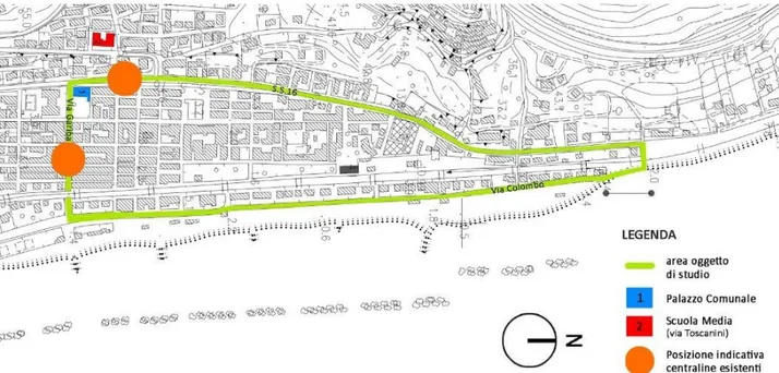
Figure 1: The urban area of Grottammare (Marche, Italy).
The International Archives of the Photogrammetry, Remote Sensing and Spatial Information Sciences, Volume XLII-2/W9, 2019 8th Intl. Workshop 3D-ARCH “3D Virtual Reconstruction and Visualization of Complex Architectures”, 6–8 February 2019, Bergamo, Italy
This contribution has been peer-reviewed.
Vr). Since then, many others have been introduced by different developers in the market.
This paper aims to fix a semi-automatic procedure for locating homologous points on two or more spherical images starting from a point cloud obtained from the same images. The points thus identified will allow you to quickly identify the same hot-spot on multiple images simultaneously linking on them data from monitoring stations located on the urban area.
3. CASE STUDY1
The research project involves the implementation of strategies aimed at optimizing and innovating services of a smart city. It has identified as its objective the realization of a prototype of a web-based platform, able to allow, using a geo-referenced 3D mapping base, the integration, management and consultation of a database concerning a series of environmental information (eg air quality, noise pollution, energy consumption related to urban infrastructures, heat loss, etc.) related to specific urban contexts (buildings, roads, service networks and systems, etc.).
The research project focused on an urban area of the territory of the municipality of Grottammare in the Marche region (Italy), classified as a climate zone D. This area has been chosen as a typical example of the widespread Adriatic town and it represents an exemplary urban area that includes all the infrastructural networks (Fig. 1).
The platform integrates the 3D model of the built architectural heritage, obtained through a survey of the area conducted with Mobile Scanner technology, with a geo-database populated by data from the sensor network set up for real-time monitoring.
4. DEVELOPED METHODOLOGY
Methodologically, the research has been divided into the following phases:
1. The identification of a smaller urban area to be used as a test for experimentation. For this reason, a part of Via Garibaldi has been chosen. In fact, Via Garibaldi crosses perpendicular both the railway and the Adriatica state road.
It also fits into an urban area characterized by the presence of both residential buildings and hotels as well as other services for the community.
2. The experimentation of different tools and methods of acquisition of spherical panoramas. In particular:
- Samsung Gear 360 spherical camera;
- Nikon D5000 SLR camera with 18mm lens mounted on Manfrotto 303SPH panoramic head;
- Equirectangular images used by Google Street View obtained through the use of the svd360.istreetview.com service.
3. Point cloud elaboration, through SFM software (Photoscan), starting from spherical images (Barazzetti, Fangi, Remondino, and Scaioni, 2010).
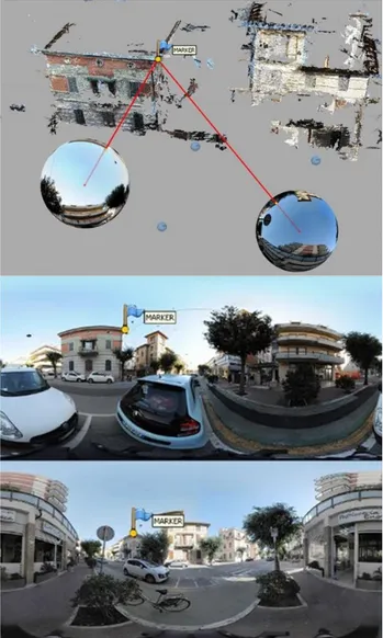
This operation was carried out with the aim of identifying a spatial relationship between the 3D data and the panoramic images and to indicate, on several images at the same time, a semi-automatic recognition procedure of the position of homologous points in 3D space that correspond to the location of sensor units in urban area (Fig. 2).
1 The experimentation discussed here is part of research project called
I.TM (Innovative Territorial Map) funded under the Programma Operativo Regionale which implements access to funding allocated by the Fondo Europeo di Sviluppo Regionale through the issue of
Figure 2: Projection of a marker point from the point of view of a couple of spherical images (top), and the identification of the same marker point on the equirectangular images (bottom). 4. The analysis of the results obtained through the comparison of data. These data come from the technical aspects (instrumentation used, and characteristics of the photographic metadata) and from the timing of shooting campaign (Tab.1). This phase will make it possible to identify instruments and procedures that are closer to achieving the final goal.
5. The design of an interactive virtual tour for the case study area. The virtual tour will be set up with hot-spots to allow the use of additional multimedia content (texts, images, etc.) for real-time monitoring of data from the environmental control units.
5. DATA COMPARISON
The comparison between the various techniques made it possible to test their effectiveness both in the first phase of data
specific calls. priority intervention (POR Marche FESR 2014-2020 – Asse 1 – azione 1.1 “promozione della ricerca e dello sviluppo negli ambiti della specializzazione intelligente”).
The International Archives of the Photogrammetry, Remote Sensing and Spatial Information Sciences, Volume XLII-2/W9, 2019 8th Intl. Workshop 3D-ARCH “3D Virtual Reconstruction and Visualization of Complex Architectures”, 6–8 February 2019, Bergamo, Italy
This contribution has been peer-reviewed.
acquisition and in subsequent processing and verification of the reliability of the results.
Data in Tab. 1 shows that the resolution of the images significantly influences the number of shooting points and the distance between them because a lower resolution of the images makes it necessary to bring the shooting location closer together and, consequently, increase their number in order to cover the same area of interest.
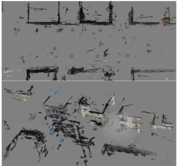
The data acquired with Samsung Gear 360 show that, despite the high number of stations, the poor resolution of the equirectangular images does not allow to obtain an accurate point cloud (Fangi, Pierdicca, Sturari, Malinverni, 2018).
This result can however be considered satisfactory if we take into account the time-saving shooting campaign (Fig. 3) and the purpose of the study that requires only the positioning of the spherical panoramas into the 3D space for automatic identification of hotspots.
Figure 3: Alignment of the spherical panoramas from Samsung Gear 360 and dense cloud processing.
In the spherical images obtained from SLR camera, the higher resolution of the images resulted in a cloud denser than the previous one but, given the small number of shots, the procedures for processing the data required manual intervention. For this reason and for the long campaign, this procedure is the most complex and time-consuming (Fig. 4).
In addition to the time dedicated to calibration based on the lens and camera used, the photographic campaign presents the common problems related to exposure and focusing. In this case, however, compared to more expeditious technologies, the number of shots that must be adequate to cover the entire sphere
of the panorama represents a discriminating factor (for this experimentation, 38 shots were made for each station).
The second processing phase for extrapolation of the point cloud using SFM systems required the preparation of the equirectangular panoramas. For the photos from Samsung Gear the procedure is almost direct, the same cannot be said for the photographs acquired through panoramic head. In fact, these images require software dedicated to stitching such as Kolor Autopano.
Figure 4: Alignment of the spherical panoramas from SLR camera on panoramic head and dense cloud processing.
Instead, Google Street View photos are a good compromise and they have produced a point cloud almost equivalent to the previous one without the need for a photographic campaign. In this case the issue is the various point cloud distribution with very dense and accurate areas and empty areas.
The biggest difference lies in the different structure of the points cloud. In this case it is possible to notice on one side very dense areas and on the other side completely empty areas (Fig. 5). In fact, downloading the data already on line has allowed us to avoid the photographic campaign. Street View Download 360 was used for the experimentation. This software allows you to directly download the equirectangular images of the service offered by Google Street View.
Although in this case the acquisition phase is very rapid because it does not require physical presence on the sites, the availability
Tools Number of shooting locations Equirectangular images resolution Distance between the shooting locations
Shooting time Point cloud
resolution RMS comparison
error Samsung Gear
360 38 5472 x 2736 2.5 m 5 sec. per shooting 1 M impossible to determine
SLR camera on
panoramic head 11 22000 x 11000 10 m 10 min. per shooting 2,5 M 0,38m
Equirectangular images from Google Street View 9 13312 x 6656 Variable ND 2,3 M impossible to determine
Tab. 1: Comparison of data in relation to the acquisition and processing techniques
The International Archives of the Photogrammetry, Remote Sensing and Spatial Information Sciences, Volume XLII-2/W9, 2019 8th Intl. Workshop 3D-ARCH “3D Virtual Reconstruction and Visualization of Complex Architectures”, 6–8 February 2019, Bergamo, Italy
This contribution has been peer-reviewed.
of data is not always guaranteed, nor the actual quality of the images. It is not rare to find errors in stitching or graphic artefacts due to the automatic procedures for the composition of the equirectangular projection.
Figure 5: Alignment of the spherical images from Google Street View and dense cloud processing.
The quality and resolution of the point cloud is strictly dependent on the number of equirectangular images available, their resolution, the accuracy of the stitching and the correct exposure of the shots.
These parameters are fully controllable only with the use of Reflex machines on the panoramic head while the 360 cameras do not allow to adjust the exposure or the resolution. With the panoramic images coming from Street View there is obviously less control on the set up of the photographic acquisitions since in this case it is not possible to decide even the number of stations.
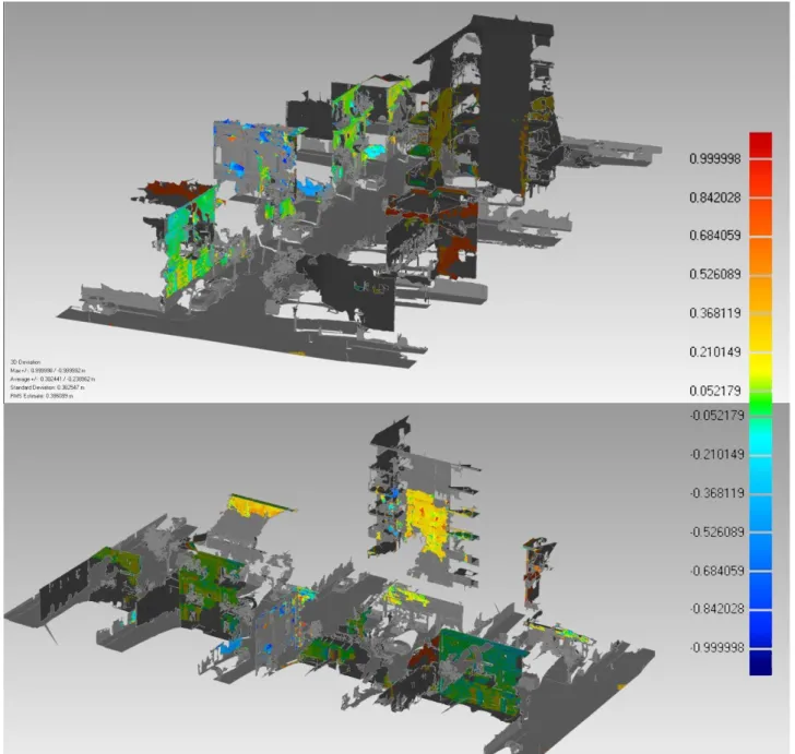
For the processing of clouds, we chose to use photogrammetric software such as Photoscan that allows you to process spherical cameras. The experimentation revealed the problems of the software in the phase of alignment of spherical images. These problems are determined to a greater extent by the limited number of panoramas or the poor resolution of the latter. From these premises, the reliability of the results was evaluated by aligning the three clouds obtained from photogrammetry with that coming from laser scanning that was used as a reference for the calculation of the standard deviation. This parameter, which
Figure 6: Standard deviation scheme: Point cloud from SLR camera panorama compared to laser scanner point cloud.
The International Archives of the Photogrammetry, Remote Sensing and Spatial Information Sciences, Volume XLII-2/W9, 2019 8th Intl. Workshop 3D-ARCH “3D Virtual Reconstruction and Visualization of Complex Architectures”, 6–8 February 2019, Bergamo, Italy
This contribution has been peer-reviewed.