SCUOLA DOTTORALE IN GEOLOGIA DELL'AMBIENTE E DELLE RISORSE
DOTTORATO IN GEOLOGIA DELL'AMBIENTE E GEODINAMICA
CICLO DEL CORSO DI DOTTORATO XXVII
SPATIO-TEMPORAL EVOLUTION OF INTRAPLATE STRIKE-SLIP
FAULTING: THE KUH-E-FAGHAN FAULT, CENTRAL IRAN
GABRIELE CALZOLARI
Nome e Cognome del dottorando
firma
FEDERICO ROSSETTI
Docente Guida/Tutor: Prof.
firma
MARTA DELLA SETA
Co-Tutor: Prof.
firma
CLAUDIO FACCENNA
Collaborations
Alexis Ault Department of Geology, Utah State University Maria Laura Balestrieri CNR-Istituto di Geoscienze e Georisorse Domenico Cosentino Dipartimento di Scienze, Università Roma Tre Claudio Faccenna Dipartimento di Scienze, Università Roma Tre
Reza Nozaem Department of Science, Imam Khomeini International University Valerio Olivetti Centre de Recherche et d’Enseignement de Géosciences
de l’Environnement
Gianluca Vignaroli Dipartimento di Scienze, Università Roma Tre
Contacts:
G. Calzolari PhD Thesis
1
Acknowledgements
I would like to express my special appreciation and thanks to my supervisor professor Federico Rossetti, for the extensive guidance and mentoring provided during the research project. I would like to thank you for supporting my research and for allowing me to grow as a researcher. Your advice during both the field campaigns and during the writing stages have been priceless. I would also like to thank you for being always available to talk to me and for your patience and the time you dedicated to me during our very long discussions, which have been so fundamental to my doctoral training. I would also like to extend my gratitude and thanks to my co-supervisor doctor Marta Della Seta, for all the new skills she has taught me and for the time she has dedicated to my training and project. I will never forget the enjoyable, joyful and productive field trips that we had together in Central Iran.
A special thanks goes to all the people with whom I collaborated in this project: Alexis Ault, Maria Laura Balestrieri, Domenico Cosentino, Claudio Faccenna, Reza Nozaem, Valerio Olivetti and Gianluca Vignaroli. Your different expertise, advice and contributions have been fundamental to the successful outcome of this multidisciplinary research project. Professor Federico Salvini is thanked for his advice during fault population analysis.
A super special thanks goes to my friend and fellow colleague Mohammad Reza Mazinani for the great company and help during the twenty days long fieldtrip we endured together in the “hot Kavir”. I would have not made it without you. I am also grateful to the guest-house manager and staff of Khaney-e-Moallem of Kashmar for their kind hospitality. I also thank Ali Rastpour and Hassan Faraji for driving to the field and logistic support.
I would also like to thank my committee members, professor Maria Rita Palombo, professor Orlando Vaselli and, doctor Marco Bonini for serving as my committee. Furthermore, I am also grateful to doctor Paolo Ballato and professor Olivier Bellier for the comprehensive review of my thesis manuscript.
Many thanks go to my ex master supervisor, lecturer and long-time hero professor Peter Kokelaar, for encouraging and supporting me to continue my academic career. I probably would not be here without his guidance.
Special thanks goes also to all the people that made the TOPOMOD Marie Curie ITN project (Grant agreement 264517) possible, and in particular to Professor Claudio Faccenna and doctor Francesca Funiciello who have invested so much time and energy of their own to make it happen.
Last but not least I would like to thank my family. Words cannot express how grateful I am to my mother and father for all of the sacrifices that you’ve made on my behalf. I would like to express appreciation to my beloved wife Maria Laura who spent sleepless nights with and was always my support in the moments when there was no one to answer my queries. At last, I would like to thank my eight month old boy Vincenzo, for giving me so much motivation in these last final months.
Spatio-temporal evolution of intraplate strike-slip faulting: the
Kuh-e-Faghan Fault, Central Iran
Abstract
L’Iran Centrale fornisce un sito ideale per lo studio della risposta morfogenetica all’enucleazione e propagazione della fagliazione intraplacca. In questo studio viene adottato un approccio multidisciplinare, che integra il rilevamento geologico-strutturale e morfostratigrafico, con analisi termocronologiche (apatite fission track (AFT), (U-Th)/He su apatite (AHe) e ematite (HeHe)), geocronologiche (Luminescenza Otticamente Stimolata, OSL), e morfometriche al fine di ricostruire l’evoluzione spazio-temporale del sistema di faglie Kuh-e-Faghan Fault (KFF), in Iran Centrale.
Il rilevamento geologico-strutturale rivela che la KFF definisce una zona di deformazione lunga circa 80 km, la quale consiste di tre principali segmenti di faglia con orientamento E-W a step sinistro e cinematica trascorrente destra, i quali tagliano il substrato paleozoico-mesozoico e le coperture sedimentarie neogenico-quaternarie. Complessivamente i dati termocronologici provenienti dalle analisi AHe e AFT indicano che i sedimenti neogenici hanno avuto temperature di seppellimento superiori ai 60°C e inferiori al 110°C. In particolare, risultati delle analisi termocronologiche AHe indicano che i blocchi intra-faglia lungo la KFF hanno vissuto due eventi di esumazione legati alla fagliazione a ~18 Ma and ~4 Ma. Il primo episodio di fagliazione/esumazione a ~18 Ma, è principalmente registrato dall’architettura deposizionale delle successioni neogeniche. In particolare, uno scenario “source-to-sink” può essere ricostruito durante il Miocene inferiore, durante il quale la crescita topografica della KFF è stata accompagnata da erosione/esumazione delle unita pre-neogniche e deposizione del materiale precedentemente eroso nei bacini strutturalmente controllati. Successivamente, la KFF gradualmente è entrata in un periodo di quiescenza tettonica, accompagnata probabilmente da subsidenza a scala regionale, durante la quale spesse sequenze di siltiti hanno ricoperto l’intera area della KFF, causando il resetting del sistema (U-Th)/He nelle apatiti contenute all’interno delle unità pre-neogeniche e alla base di quelle neogeniche. Il secondo episodio di fagliazione a ~4 Ma ha causato l’ultimo evento di esumazione ed ha originato l’attuale architettura strutturale della zona di faglia e la configurazione topografica della KFF. Le analisi termocronologiche HeHe eseguite su specchi di faglia decorati ad ematite registrano sia età correlabili al primo evento di (>6-4Ma), sia al secondo evento (<6-4 Ma) di fagliazione/esumazione; di fatto confermando la storia d’esumazione polifasica del sistema di faglie KFF.
L’integrazione del dataset strutturale, stratigrafico e termocronologico indica che la KFF si è nucleata ad ovest e si è propagata verso est in maniera polifasica.
G. Calzolari PhD Thesis
3
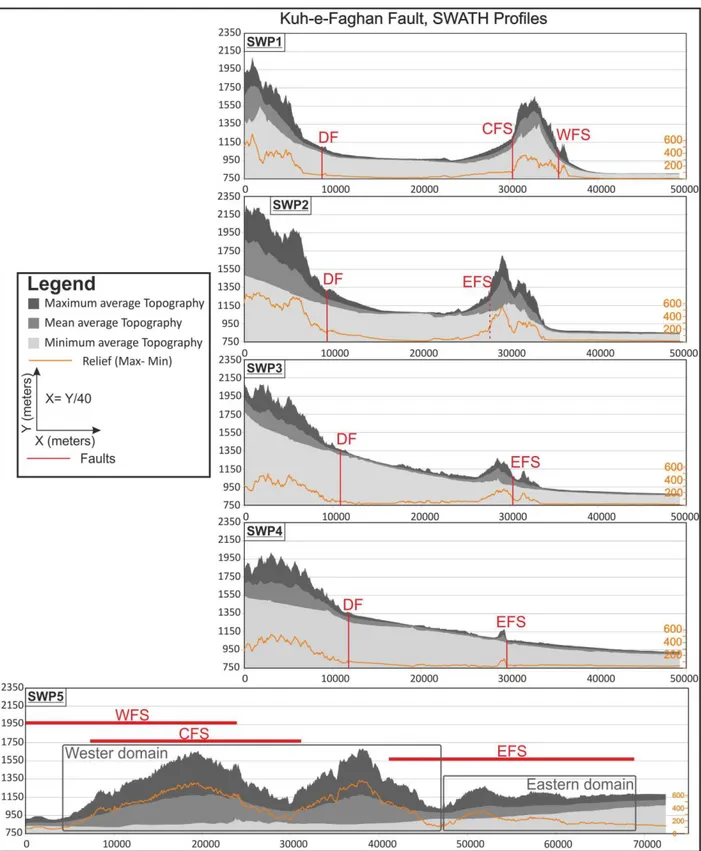
L’analisi topografica del sistema KFF rivela che i due eventi di propagazione ed esumazione, i quali hanno formato l’architettura strutturale e stratigrafica del sistema di faglie, possono essere riconosciuta nella configurazione topografica della KFF. In particolare, il primo rilievo (and ovest) con una lunghezza d’onda di 10 km, corrispondente al western topographic domain lungo ~42 km e il secondo rilievo (ad est) corrispondente all'eastern topographic domain lungo ~23 km sono identificati rispettivamente come segnali topografici residui del primo (~ 18 Ma) e secondo (4 ~ Ma) evento d’esumazione. L’analisi geomorfologica e geocronologica (OSL) dei depositi di conoide alluvionale e di piana alluvionale che circondano la KFF mostrano che la genesi e lo sviluppo di tali depositi è stata primariamente controllata da fasi climatiche di aggradazione tardo-quaternarie e oloceniche già riconosciute da altri autori in tutto l’Iran. Ciononostante, la documentata configurazione e lo stile di deposizione di tali depositi indica che sono stati fortemente influenzati dall’attività tettonica del sistema di faglie e dalla conseguente riorganizzazione del reticolo idrografico. In particolare, le datazioni OSL su quarzo dei depositi quaternari fagliati indica che la KFF debba essere considerata una faglia attiva. L’analisi morfometrica dell'inclinazione delle superfici sommitali dei conoidi alluvionali quaternari rivela che la crescita topografica della KFF è ancora attiva.
I principali risultati di questo studio portano importanti implicazioni circa: (i) la comprensione dell’evoluzione spazio-temporale del e propagazione dei sistemi di faglie trascorrenti intraplacca, (ii) la risposta intraplacca alle riorganizzazioni tettoniche lungo i margini collisionali, e (iii) l’evoluzione cinematica e tettonica neogenico-quaternaria in Iran Centrale.
(i) In questo lavoravo viene proposto un modello concettuale sull’enucleazione e la propagazione della fagliazione trascorrente intraplacca. Il modello prevede che la deformazione sia inizialmente delocalizzata ed distribuita lungo set di faglie en-echelon le quali controllano la crescita topografica iniziale e la localizzazione dell’erosione/sedimentazione. Le proprietà meccaniche di strain hardening e velocity-strengthening dei depositi sin-tettonici causano la progressiva inibizione della fagliazione all’interno dei depositi, causando la progressiva migrazione verso l’interno delle principali zone di faglia. Questo processo risulta in una localizzazione della deformazione lungo segmenti di faglia ben definiti e maturi. La dissipazione del rigetto trascorrente lungo le terminazioni dei principali segmenti di faglia viene ottenuta attraverso lo sviluppo di trailing extensional imbricate fan i quali inibiscono ulteriormente la propagazione delle zone di faglia. Tali terminazioni estensionali/trastensive sono associate a depocetri in subsidenza tettonica i quali controllano fortemente la distribuzione e gli spessori dei depositi associati. Conseguentemente il sistema di faglia si propaga attraverso la creazione di nuovi segmenti, con deformazione a carattere diffuso, in zone indeformante, lungo il tip del sistema di faglia.
(ii) I due eventi di esumazione legati alla fagliazione, documentati a ~18 and ~4 Ma lungo la KFF, coincidono con gli eventi regionali di accelerazione dell’esumazione legata alla collisione
continentale durante il Miocene inferiore, e di riorganizzazione tettonica della zona di collisione Turco-Iraniana durante il Miocene superiore-Pliocene inferiore. Pertanto questo studio mostra che l’evoluzione a lungo termine della KFF, situata nell’intraplacca iraniano, è caratterizzata da una storia polifasica d’esumazione legati alla fagliazione, quasi coincidenti con i due eventi tettonici registrati lungo il margine di placca. Questo suggerisce che i sistemi di faglia intraplacca siano particolarmente sensibili alle variazioni dei regimi di stress (far-field) che operano lungo i margini di placca e, di conseguenza, il loro studio può fornire importanti vincoli alle variazioni dei regimi tettonici ai margini di placca.
(iii) I risultati di questo studio, assieme a quelli recentemente pubblicati da altri autori, impongono una rivalutazione dell’evoluzione spazio-temporale e cinematica dell’Iran Centrale nel quadro della storia di collisione e convergenza di Arabia e Eurasia. In questo studio viene proposto che la deformazione neogenico-quaternaria dell’Iran sia stata principalmente controllata dal grado di accoppiamento lungo l’interfaccia collisionale Arabia-Eurasia. La variazione nello spazio e nel tempo di tale accoppiamento, insieme alla capacità di accomodare la convergenza lungo la zona di collisione, hanno controllato la quantità di convergenza trasferita ai domini intraplacca e pertanto hanno controllato la distribuzione, la cinematica e la configurazione della deformazione nello spazio e nel tempo.
Abstract
Central Iran provides an ideal test site to study the morphotectonic response to enucleation and propagation of intraplate faulting. In this study, a multidisciplinary approach that integrates structural and stratigraphic field investigations with geochronological (optically stimulated luminescence, OSL) and thermochronological (apatite fission track (AFT), (U-Th)/He su apatite (AHe) e ematite (HeHe)) analyses, is used to reconstruct the spatio-temporal evolution of the Kuh-e-Faghan Fault (KFF), in northeaster Central Iran.
Structural mapping reveals that KFF defines a narrow, ca. 80 km long, deformation zone consisting of three main broadly left stepping, E-W trending, right-lateral fault strands which cut through the Mesozoic-Paleozoic substratum and the Neogene-Quaternary sedimentary covers. The AHe thermochronology results indicate that the intra-fault blocks along the KFF experienced two major episodes of fault-related exhumation at ~18 Ma and ~4 Ma. The first faulting/exhumation episode at ~18 Ma is chiefly recorded by the Neogene deposits architecture along the KFF. In particular, a source-to-sink scenario can be reconstructed for this time frame, when topographic growth caused the synchronous erosion/exhumation of the pre-Neogene units and deposition of the eroded
G. Calzolari PhD Thesis
5
entered a period of relative tectonic quiescence and, probably, regional subsidence during which a thick pile of fine-grained onlapping sediments were deposited, caused the resetting of the (U-Th)/He system of the detritic apatite grains hosted both within the pre-Neogene and the basal Neogene successions. AFT dating indicates that the basement units, that are now exposed to the surface, where most probably below the closure temperature (100-120 °C) of the AFT system during the first exhumation event (at ~18 Ma) and, similarly, the AFT system of the pre-Neogene and Neogene deposits have not been reset by Miocene burial (>4 Ma). Together, the AHe and AFT data from the Neogene basin sediments imply burial temperatures in excess of ~60 °C and less than 100 °C. The second faulting episode at ~4 Ma caused the final fault exhumation event, resulting in the current fault zone and topographic architecture. The HeHe ages of hematite coated fault surfaces register both formation ages during the first exhumation event (>6-4Ma) and exhumation ages during the second exhumation event (<6-4 Ma), thus confirming the polyphase history of the KFF system. Collectively the stratigraphic, structural and thermochronological datasets shows that the KFF enucleated in the west and propagated eastward in two punctuated events.
Topographic analysis of the KFF reveals that the two fault propagation and exhumation events that shaped the structural and stratigraphic architecture of the fault system can be recognized in the current topographic configuration of the KFF. In particular 10-km wavelength relief corresponding to the ~42 km long western topographic domain and the overall eastward narrowing and decreasing in elevation and relief,~23 km long eastern topographic domain, are identified as the remnant topographic signals of the first (~18 Ma) and second (~4 Ma) exhumation event, respectively.
Geomorphological analysis and OSL dating of the KFF Quaternary alluvial deposits show that the generation and development of the deposits where primarily controlled by late Quaternary and Holocene, climate-driven aggradation phases recognized throughout the Iranian plateau by other studies. Nevertheless, their geometric configuration and style of deposition documented along the KFF indicated that they have been strongly influenced by the fault system tectonic activity and the consequent drainage network rearrangement. In particular OSL of quartz grains from faulted alluvial deposits indicates that the KFF is interested by active E-W oriented, Late Pleistocene to Holocene right-lateral tectonics. The morphometric slope analysis of the quaternary alluvial deposits indicates that the KFF is still producing fault related topographic growth.
The major outcomes of this study have important implications on (i) understanding the propagation and spatio-temporal evolution of intraplate strike-slip fault systems; (ii) the intraplate response to tectonic reorganization at the collisional boundaries; and (iii) the Neogene-Quaternary kinematic and tectonic evolution of Central Iran.
(i) A conceptual model of fault initiation and propagation is proposed. Deformation starts from diffuse deformation accomplished by distributed en-echelon shears, which control initial topographic
growth and focused erosion/sedimentation. The strain hardening and velocity-strengthening properties of the syn-tectonic sedimentary deposits progressively inhibits the fault propagation and causes the overall inward migration of the fault zone. This results in an overall localization of the shear deformation along thoroughgoing fault strands and creation of mature fault zones. Strike-slip shear dissipation at eastern fault zone terminations is achieved through the development of trailing extensional imbricate fan, inhibiting further length-ward fault propagation. The extensional/transtensional faulting and the associated tectonically-controlled subsiding depocenter, strongly control the deposits distribution and thicknesses. As a result, the fault systems may then propagate by renewed diffuse shear deformation in undeformed regions at the fault tip, creating new fault strands.
(ii) The two fault-related exhumation episodes, at ~18 and ~4 Ma, well fit with the regional early Miocene collision-enhanced uplift/exhumation and the late Miocene–early Pliocene widespread tectonic reorganization of the Turkish-Iranian collision zone, respectively. As suchthe study shows that the long term evolution history of the KFF system in intraplate Iran is characterized by punctuated events nearly coincident with major tectonic events at the plate boundaries. This strongly suggests that the intraplate response along strike-slip fault systems is particularly sensitive to major (far-field) tectonic changes occurring at the plate boundaries, and, as such, intraplate deformation zones can be regarded as a gage for plate-tectonics induced state of stress changes at the plate boundaries.
(iii) Results from this study, together with the outcomes from recently published studies, impose a reappraisal of the spatio-temporal kinematic evolution of Central Iran in the aftermath of the Arabia-Eurasia collision history. It is proposed that the Neogene-Quaternary deformation in Iran has been primarily controlled by the spatial and temporal variations in the degree of coupling along the Arabia-Eurasia collision interface. The spatio-temporal changes in the degree of coupling, together with the capacity of accommodating convergence along the collision zone, controlled the amount of northward convergence that was transferred to the intraplate domain and therefore controlled the deformation distribution kinematic configuration in space and time. The revised tectonic/kinematic model needs to be improved and validated by further studies to be carried out along the major fault systems of south-central Iran, in order to verify their persistence, distribution, kinematics and overall space-time evolution.
G. Calzolari PhD Thesis 7
CONTENT
Acknowledgements ... 1 Abstract ... 2 CONTENT ... 7 1 INTRODUCTION... 101.1 Hints from modelling ... 13
1.2 Hints from natural strike-slip fault systems ... 18
1.3 Topographic growth and exhumation ... 20
1.4 Investigating continental deformation... 21
1.5 Open Questions ... 23
2 AIMS OF THE RESEARCH AND RATIONALE ... 25
3 GEOLOGICAL BACKGROUND ... 27
3.1 Regional tectonic setting ... 27
3.2 Central Iran ... 28
3.3 The study area ... 29
4 METHODOLOGY ... 32
4.1 Field work ... 32
4.1.2 Structural survey ... 32
4.1.3 Stratigraphic survey ... 32
4.1.4 Geomorphological survey ... 32
4.2 Digital Elevation Model and topographic analysis ... 33
4.3 Sampling and analytical work ... 34
4.3.1 Apatite (U-Th)/He (AHe) and Apatite Fission Tracks (AFT) dating ... 34
4.3.2 Hematite (U-Th)/He (HeHe) dating ... 35
4.3.3 OSL dating ... 36
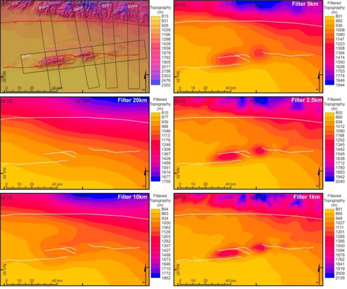
5 TOPOGRAPHIC SIGNATURE OF THE KFF ... 38
6 NEOGENE STRATIGRAPHY ... 42
6.1 Stratigraphic cycles and units... 42
Cycle-1 ... 42
Cycle-2 ... 47
Cycle-3 ... 47
7 QUATERNARY LANDFORMS AND DEPOSITS ... 50
7.1 Sedimentological characters ... 55
8 STRUCTURAL DATA AND FAULT KINEMATICS ... 59
8.1 Western fault strand ... 61
8.2 Central fault strand ... 64
8.3 Eastern fault strand ... 66
8.4 Minor Faults ... 70
8.5 Fault zone architecture ... 72
8.6 Quaternary faulting ... 72
9 MORPHOMETRIC ANALYSIS ... 74
9.1 Alluvial fan slope analysis ... 77
9.1 Results ... 77
10 THERMOCHRONOLOGY AND GEOCHRONOLOGY ... 80
10.1 Apatite (U-Th)/He (AHe) and Apatite Fission Tracks (AFT) dating ... 80
10.2 Hematite (U-Th)/He (HeHe) dating ... 83
10.3 Optically Stimulated Luminescence (OSL) dating ... 85
10.3.1 Results ... 86
11 DISCUSSION ... 89
11.1 Structural synthesis ... 89
11.2 Stratigraphic architecture: linking faulting to sedimentation ... 92
11.3 A two stage exhumation history ... 94
11.3.1 AHe and AFT dating ... 94
11.3.2 HeHe dating ... 96
10.4 Quantifying and comparing exhumation and slip rates ... 97
11.5 The long-term evolution of the Kuh-e-Faghan Fault: enucleation, propagation, and topographic growth ... 98
11.5.1 Fault system nucleation ... 99
11.5.2 Fault localization and propagation ... 99
11.5.3 Fault termination and tectonic quiescence ... 100
11.5.4 Renewed faulting ... 100
11.6 Topographic signal of KFF and geomorphic response to active tectonics ... 107
11.6.1 Linking exhumation history, style of deformation and topographic signal of KFF 107 11.6.2 Constraints on Quaternary morpho-evolution ... 108
11.6.3 Constraints on fault-related Quaternary uplift ... 109
G. Calzolari PhD Thesis
9
11.7.2 Implications for topographic growth along intraplate strike-slip faults ... 114
12 SUMMARY AND CONCLUSIONS ... 115
References ... 119
Appendix ... 136
Appendix-A Figure location map ... 136
Appendix-B Structural data... 137
Appendix C: Manuscript submitted to GSA Bulletin the 2nd of January 2015 ... 152
1 INTRODUCTION
Strike-slip tectonics is a fundamental process affecting many parts of the Earth's lithosphere and resulting in prominent tectonic, geophysical and topographic expressions (for general review Biddle, 1985; Christie-Blick, 1985; Harding, 1985, 1990; Holdsworth et al., 1998; Lowell, 1985; Storti et al., 2003; Sylvester, 1984; Sylvester, 1988; Till, 2007; Woodcock and Schubert, 1994; Woodcock and Fischer, 1986).
Since the recognition of strike-slip dominated plate boundaries, also known as transform faults (Wilson, 1965), several studies have identified their geometric linkage and kinematic interaction with constructive and destructive plate margins (e.g. McKenzie and Parker, 1967; Morgan, 1968). Such studies were instrumental to the emergence of the plate tectonics theory, which assumes that lithosphere within the plate interior is to be considered rigid and plate motion-related deformation and interactions are concentrated along narrow belts outlining the plate boundaries. Despite this scenario well fits with oceanic plate settings, as attested by the seismic activity located along their active plate boundaries, deformation distribution in continental regions is complicated by the non-rigid behavior of the continental lithosphere (Molnar, 1988). This has been attributed to a week quarzo-feldspatic dominated rheology of the continental lithosphere and to the occurrence of mechanical anisotropies (such as shear zones), which may be promptly reactivated during episodes of regional deformation (Di Vincenzo et al., 2013; Holdsworth et al., 2001a; Holdsworth et al., 2001b; Kocyigit and Beyhan, 1998; Marshak et al., 2003; Morley, 2007; Rutter et al., 2001; Storti et al., 2003; Vauchez and Tommasi, 2003). This behavior is well illustrated in regions affected by continental collision, where seismicity extends deep into the continental plate interiors defining broad diffuse zones of deformations (e.g. Central Iran, Turkey and Tibetan plateau Hatzfeld and Molnar, 2010; Fig. 1.1). It may be useful to view such regions of non-rigid behavior as broad, diffuse plate boundaries (e.g. Gordon, 1998 and references therein) but in the present work we shall refer to all regions located away from the major plate boundaries as 'intraplate' (as defined in: Storti et al., 2003). In such settings the stresses and forces that produce intraplate deformation are thought to be governed by plate margin dynamics (England and McKenzie, 1982; Molnar, 1988; Tapponnier and Molnar, 1976). In particular it has been shown that the most important factor controlling the transmission of stresses from the plate boundaries to the intraplate domains is the degree of tectonic coupling at the collisional interface (Ellis, 1996; Ziegler et al., 1998). Figure 1.2 summarizes Ellis’s (1996) theoretical work on continental deformation. As demonstrated by regional and global stress field maps (e.g. Heidbach et al., 2001; Heidbach et al., 2008; Zoback, 1992), compressional horizontal stresses can be transmitted from the plate boundaries across very large distances, through continental and oceanic lithosphere. In fact, compressive intraplate deformation can be found at distances up to
G. Calzolari PhD Thesis
11
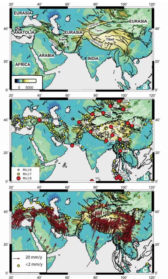
Figure 1.1 Topographic maps of Asia showing the (a) major fault system associated with orogenic belts and intraplate deformation terrains, (b) the historic and instrumental seismicity and (c) the GPS velocity vectors velocities in a frame of stabile Eurasia. After Hatzfeld and Molnar (2010)
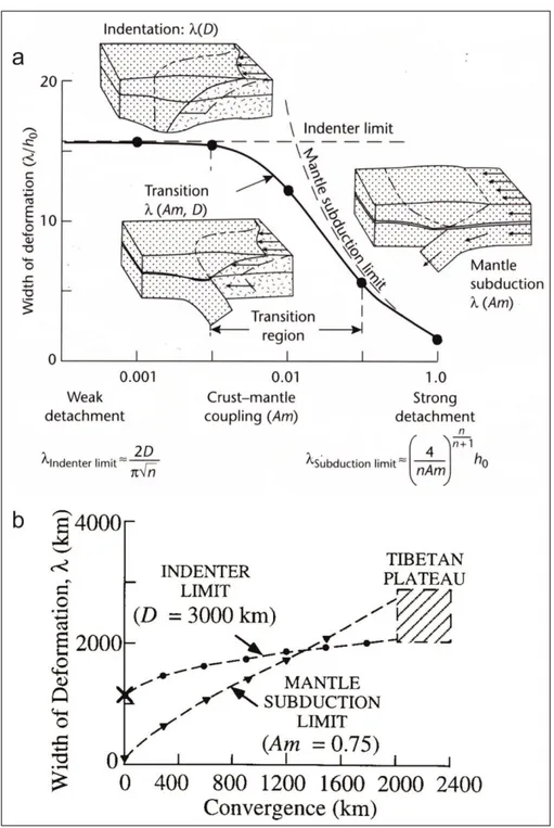
Figure 1.2 Ellis (1996) work on continental deformation theory. Figure after Ellis (1996). Terms: λ= deformation over an across strike width; D= along strike indentation length scale; n= power law exponent of viscous sheet; Am= Ampferer number; h0 = original thickness of the crust. (a) The figure shows how with a small amount of continental convergence the continental deformation zone width is controlled by the degree of crust-mantel coupling at the collision interface. With a highly coupled system intraplate deformation is dominated by indentation processes (England and McKenzie, 1982; Tapponnier and Molnar, 1976) while if the system is weakly coupled intraplate deformation is dominated by mantel subduction processes (Ellis, 1995). (b) shows how the deformation width changes with increasing convergence for mantle subduction and indenter.
±1600 km from the collision front (Ziegler et al., 1995). As attested by seismological and geodetic studies on intraplate neotectonics (e.g. Allen et al., 2011; Molnar and Tapponnier, 1975; Nilforoushan et al., 2003; Vernant et al., 2004; Walpersdorf et al., 2014), strike-slip faulting is the primary process
G. Calzolari PhD Thesis
13
by which such horizontal movements are accommodated and stresses are transferred further away from the collision front (Fig.1.1).
Strike-slip dominated continental deformation zones typically consists of interlinked systems of fault- and shear zone-bounded blocks that partition strains to form complex regions of displacement, internal distortion and rigid block rotations on various scales (e.g. Dewey et al., 1986; Foster and Gleadow, 1992; Marshak et al., 2000; Storti et al., 2003; Walker and Khatib, 2006). This is mostly due to the intrinsic structural inheritance of continental crust and lithosphere, acquired through the continuous incorporation of plate margin structures by continental collision and accretion processes, that operate for geologically long periods of time. Such structures, constitute major zones of mechanical anisotropy and vertical planar fabric, which, once incorporated into the plate interiors, influence the location, orientation and style of deformation during successive phases of reactivation at various spatial and temporal scale (Holdsworth et al., 2001a; Salvini et al., 1997; Sutton and Watson, 1986). These weak zones are preferentially reactivated by strike-slip faulting because, energetically speaking, it requires the least “effort”, but also because of their vertical geometry. In fact, intraplate strike-slip system often display polyphase reactivation histories, which may record tens to hundreds million years of deformation history (Pinheiro and Holdsworth, 1997; Rossetti et al., 2002; Walker and Khatib, 2006). The longevity of intraplate strike-slip fault system and there intimate linkage to plate boundary dynamics makes them excellent “recorder” of the intraplate deformation response to continental collision. Furthermore they represent zones of economic interest and important areas of elevated geological hazard (Storti et al., 2003). In particular, they are capable of producing extremely destructive earthquakes (e.g. north Anatolia, Turkey, Sengor et al. (2005) and Tan et al. (2008); Dasht-e-Bayaz, Central Iran,Tchalenko and Ambraseys (1970); Walker et al. (2004); Berberian (2014) hundreds of kilometers away from the plate boundaries. Moreover, intraplate strike-slip faults often influence location, geometry, subsidence history and evolution of associated hydrocarbon rich sedimentary basins (for reviw Morley, 2002) and additionally may control magma emplacement and distribution and the associated hydrothermal circulations, producing economically valuable ore deposits and geothermal reservoirs (Araujo et al., 2005; Cox, 1999; Cox and Ruming, 2004; Wannamaker et al., 2009).
1.1 Hints from modelling
The recognized importance of intraplate strike-slip fault systems and their long-lasting developmental history has driven the creation of an enormous amount of studies in the last decades. Knowledge about fault nucleation and propagation mechanics, fault zone geometries and architectures and style of deformation has progressed enormously. Nevertheless, the understanding
on how intraplate strike-slip fault systems propagate and evolve in space and time at the fault system scale, principally come from analogue modeling studies. Although experimental studies have inherent simplifications, such as, a simplified mechanical stratigraphy, the neglect of thermal flexural and isostatic effects, they allow us to observe the 3-D geometry of the developing structure.
Dooley and Schreurs (2012) extensively and exhaustively reviewed the huge literature on analogue modelling of intraplate strike-slip tectonics. Such review study shows that the models can be divided into two main categories: (i) Riedel experiment (Fig. 1.3), with structures forming in an overburden above a single planar and vertical basement fault reactivated in pure strike slip (Atmaoui et al., 2006; Burbidge and Braun, 1998; Cloos, 1928; Lazarte and Bray, 1996; Le Guerroué and Cobbold, 2006; Richard and Cobbold, 1990; Richard and Krantz, 1991; Richard et al., 1991; Richard et al., 1995; Riedel, 1929; Tchalenko, 1970); and (ii) Distributed strike-slip shear experiments (Fig. 1.4), with structure forming above a broad shearing plane (Davis et al., 2000; Gapais et al., 1991; Schreurs, 2003; Schreurs and Colletta, 1998; Schreurs and Colletta, 2002).
Variations in the modeling material (sand, dray/wet clay), mechanical stratigraphy of the model and model thickness produce marked differences. Nonetheless, some important distinctions for the two different groups of experiments are recognized and outlined by Dooley and Schreurs (2012).
Riedel experiments performed with granular materials such as sand show a lower variability in structural style than clay models. In clay experiments, faults, tension fractures, pull-apart structures, and folds have all been described in the published literature, although not all of these structures necessarily formed in one and the same model (Fig. 1.3a; Dooley and Schreurs, 2012). In sand experiments, only faults develop, except for the region in between closely overlapping en-echelon Riedel shears (R), where local uplift is accommodated by antiformal structures trending parallel to the strike of the shears (Fig. 1.3b and c; Dooley and Schreurs, 2012).
Generally, the first structures to appear at the surface are, partly overlapping, en-echelon R synthetic shears, striking at an angle of about (~15° to 20°) clockwise to the trace of the basement fault (Fig. 1.3a and b). Such shear tend to extend lengthward, creating a slightly sigmoidal surface trace above the basement fault trace. In 3D, R-shears show a helicoidal shape that connects the sigmoidal surface fault trace with the basement fault at depth (Fig. 1.3c). With increasing displacement, short-lived splay faults formed at or near the tips of the R shears. Subsequently, synthetic P-shears develop at a low counterclockwise angle from the trace of the basement fault. Linkage of portions of all these shears result in the formation of a through-going, anastomosing fault zone called Principal Displacement Zone, PDZ, whose overall strike was parallel to the basement
Figur e 1.3: Ty pi cal f ra ct u re and fau lt p ar en t dev el o pm ent i n w et cl ay (e xper im en t fr om T cha lenko , 1970 ) (a ) and dr y sa nd (exp er im ent f rom N ay lor et a l., 19 86 ). (b) R iede l she ar expe ri m en t fo r incr ea si ng d isp la ce m en t (D ) v al u es and as so ci at ed st ruc tu re d eve lop m en ts f o r tw o st age s of pr o gr ess ive d ext ral she ar de for m at io n. (c) 3D , geo m et ry o f a R -sh ea rs faul t show ing an he li coi da l sha p e w hi ch con nec ts t o the si gm o ida l sur fa ce faul t tr ace w it h the b as em ent f aul t a t dep th. F igu res af ter D oo ley a nd Sch reu rs (20 12 )
fault (Fig. 1.3b).In clayexperiments after the later deformation stages, anthythetic R’-shear develop at high angle (90-~75°) clockwise from and segmenting the PDZ.
In models undergoing distributed strike-slip shear, shearing is initially accommodated by a network of distributed en-echelon R-shear fault sets (Fig. 1.4a). Push-up zones form in the interaction areas between adjacent stepping R-shears. Adjacent R-shears merge by sideways propagation or link by short synthetic shears that strike sub-parallel to the bulk shear direction. Coalescence of en-echelon R-shears results in major, through-going master faults (Fig. 1.4a and b). Several parallel master faults develop due to the distributed nature of deformation. These major, through-going fault zones produce secondary faults, such as lower-angle synthetic and antithetic shears, which reflect local (kinematic) stress-field modifications (Fig.1.4).
The same experiments were also performed applying a degree of shortening or extension perpendicular to the bulk shear direction to simulate transpressional and transtensional strike-slip regimes. Although the pattern of faulting changed depending on the degree of obliquity and the experimental setup some generalization can be made (Dooley and Schreurs, 2012).
Generally in experiment with transtension (e.g. Naylor et al., 1986; Richard and Cobbold, 1990) deformation zones are narrow and simple, with steeply dipping (dip > 70°) synthetic shears striking at a lower angle to the basement fault than in the simple-shear experiments. In transpression experiments, the strike-slip deformation zones are instead wider and more complex, with the synthetic shears striking at higher angles with respect to the basement fault. In distributed strike-slip experiments with transtension (Schreurs and Colletta, 1998), initial faults form with a lower angle to the imposed shear direction accommodate horizontal displacements together with parallel dominated by extensional throws. In distributed transpression experiments (Schreurs and Colletta, 1998; Schreurs and Colletta, 2002) with low angles of obliquity (≤15°) generate initial strike-slip faults, whose surface strike is at higher angles than those of R shears in distributed strike-slip shear experiments.
Furthermore, a vast amount analogue and numerical modelling studies have been produced on single structural elements and geometric configurations of strike-slip systems. Those include releasing bend (e.g. Atmaoui et al., 2006; Dooley and McClay, 1997; Dooley et al., 1999; Hempton and Neher, 1986; Petrunin and Sobolev, 2008; Wu et al., 2009), stopover geometries (e.g. Dooley et al., 1999; McClay and Bonora, 2001; Mitra and Paul, 2011; Richard et al., 1995) and termination structures (e.g. d'Alessio and Martel, 2004).
Le Guerroué and Cobbold (2006) investigated the effect of erosion and sedimentation along a developing single strike-slip fault. They designed a set of Riedel experiment in dray sand with structures forming in an overburden above a single planar and vertical basement fault. In some
Figur e 1.4 : Typ ic al f rac tur e and fau lt pa tt er n deve lop m en t in d ray sa nd di st ri bu ted st ri ke -sl ip she ar expe ri m en t, for in cr eas in g di spl ac em en t val ues (γ ). (b ) C onc ept ual m ec ha ni ca l and te m po ra l deve lopm en t o f fau lt and f rac tu re popu la ti on w it h i n cr ea si ng shea r di spl ace m en t ( R , R ’ than M ; t han R L and R ’L) . Figu re s a ft er Schr eu rs (2003 ).
experiments, uplifted areas where subjected erosion. In other experiments, all surface areas were subject to sedimentation. Successively the two processes were combined. From their study, it emerges that positive flower geometries, which normally form along restraining bends (Mann, 2007) or in overall transpressive regimes (Woodcock and Rickards, 2003), commonly form after substantial pure-strike displacement along the entire fault system, developing substantial linear relief. In experiments with erosion and sedimentation, some faults propagated through their syn-kinematic cover, others became buried and inactive, whilst yet others were exposed by erosion. This caused the average fault dip to progressively increase and the fault zone to narrow, focusing and localizing the uplift along the central portion of the fault (Le Guerroué and Cobbold, 2006).
Another important aspect of strike-slip faulting, extensively studied by modelers, is fault propagation in brittle rocks. Two main fault propagation processes have been identified: (1) propagation by shear fracture within the host rock where faults grow by the development of a ‘process zone’ where microfractures forming near the fault tip eventually coalesce into a through-going fault (Cowie and Scholz, 1992; Scholz et al., 1993; Tuckwell et al., 1999; Vermilye and Scholz, 1998) and (2) linkage of fault segments that originate as planes of preexisting weaknesses (Martel and Pollard, 1989; Segall and Pollard, 1983). The two processes produce distinct pattern of fracture damage. In the first instance the stress concentration at the fault tip, which allows the length ward propagation of the fault migrates with the fault tip, progressively creating fracture damage along the entire fault. Conversely, when fault propagate by linking to neighboring structures the stress concentration operates only at the tip of the linking structure, resulting in a fracture damage to be principally distributed along the linking segments. Preexisting facture damage however can inhibit fault propagation by a process known by “crack-tip shielding” (d'Alessio and Martel, 2004). In this instance a pervasive fracture network at the tip of the fault can diffuse and therefore reduce the stress concentration at the fault tip effectively stopping further lengthward propagation. Depending on the kinematic and stress field of the fault in question and on the orientation of the fracture network the fault may splay out at an angle to the main fault and create transpressive or transtensive terminations.
1.2 Hints from natural strike-slip fault systems
Riedel experiments are thought to represent good analogues for fault systems that form above a reactivated basement fault, while distributed strike-slip shear are thought to better represent deformation in intraplate setting where deformation is distributed over broad areas (Dooley and Schreurs, 2012). It is clear from all analogue-modelling studies that the development of strike-slip fault systems are dominated by Riedel shear structures. This makes the modelling studies particularly useful and relevant when looking at natural examples of strike-slip fault. In fact Riedel shear structures have been reported in nature at the macro-scale in coseismal surface rupture (e.g.
G. Calzolari PhD Thesis
19
Tchalenko and Ambraseys, 1970), within the basement faults (e.g. Moore, 1979), in intraplate settings (e.g. Cunningham, 1993) and also at the meso- and micro-scale (e.g. Ahlgren, 2001; Antonellini and Aydin, 1995; Arboleya and Engelder, 1995; Jamison and Stearns, 1982).
The results from these analogue modelling studies have been therefore instrumental in identifying the structural geometry and the theoretical temporal progression of fault population generation during the nucleation and propagation of strike-slip faults system. This partially explains the wide collection of faults orientations observed along regional strike-slip systems (e.g. Rossetti et al., 2002; Storti et al., 2006). However, in natural examples of strike-slip systems, the fault development is complicated by a combination of: (i) regional or far field stress, (ii) transient kinematically induced stress field, (iii) local rotation of regional stress in the fracture damage zones and (iv) coexisting transpressional and transtensional fault segments, results in very complex fault patterns at different spatial and temporal scales (Davis, 1984; Faulkner et al., 2006; Mandl, 2000; Storti et al., 2006; Sylvester, 1988; Tchalenko and Berberian, 1975; Woodcock and Schubert, 1994; Woodcock and Fischer, 1986). This is particularly important in intraplate settings where dynamically and kinematically induced stress fields interact with mechanical anisotropies of the continental lithosphere and ultimately control the distribution of deformation. Overall, this commonly produces intraplate strike slip-system with complex patterns of fault population reflecting spatial and temporal variations in structural style along a fault zone (Fig. 1.5). Those include:
(1) Termination structures forming at the tip of intraplate strike-slip systems which include: (i) normal faults, forming a wing cracks type geometry (e.g. the La Tet strike–slip fault, Cerdanya Basin, eastern Pyrenees Cabrera et al. (1988)), (ii) Horsetail splay faults also refered to as trailing imbricate fan (Woodcock and Fischer, 1986), which may be extensional (e.g. Ales’s Basin at the tip of the Villefort’s Fault, FranceGranier (1985)) or contactional (e.g. Lucanian Apennines, Southern Italy, Catalano et al. (1993)), (iii) synthetic branch fault (e.g. along a segment of the North Anatolian Fault, Turkey Barka and Kadinsky-Cade (1988)), (iv) anythetic fault sets in front of the fault tip (e.g. Malta Fault in the Rio do Peixe Basin, Brazil (Françolin et al., 1994)). Furthermore regional strike-slip systems may terminate into rift systems (e.g. Priestley Fault which terminates into the Terror rift, north Victoria Land, Antarctica, Storti et al. (2001)) and orogenic systems (e.g. western Mongolia, Bayasgalan et al. (1999) and Altyn Tagh fault system of central Asia, Cobbold and Davy (1988)).
(2) Releasing bends and stepover forming within fault system, constitute a rhomboidal generally transtensive segment of the fault system. They typically create depression that, become depocenter called pull-apart basins which sedimentary history and faces distribution is intimately linked to the tectonic evolution of the bounding fault system (for general review
Aydin and Nur, 1982; Blair and Bilodeau, 1988; Cunningham and Mann, 2007; Ioganson, 2005; Mann, 2007).
Figure 1.5. (a) It shows the possible range of coexisting structural styles along a strike-slip system. (b) Releasing and restraining bends and step over structural geometries. Figure after Dooley and Schreurs (2012), original diagram from Christie-Blick (1985).
(3) Restraining bends and stepover forming within fault system they constitute a generally rhomboidal transpressive segment of the fault system. Typically they are associated with prominent topography, they form anticlinal uplifts, commonly with doubly plunging arrangements of folds, and are of limited strike (for general review Christie-Blick, 1985; Cunningham and Mann, 2007; Mann, 2007; Zolnai, 1991).
1.3 Topographic growth and exhumation
Strike-slip fault system have always been known for their capacity to produce prominent topography (Storti et al., 2003; Sylvester, 1988; Woodcock and Schubert, 1994). Outcrops of middle to deep crustal material are commonly found in association with strike-slip fault systems (Fitzgerald et al., 1995; Redfield and Fitzgerald, 1993) and studies of metamorphic rocks within strike-slip fault systems document that at least part of their exhumation pathways is synchronous with strike-slip
G. Calzolari PhD Thesis
21
movement (Foster et al., 2007; Gordon et al., 2010; Roeske et al., 2007). Additionally, strike-slip fault systems are often associated with regions of focused rapid exhumation > 0.5 mm/y (e.g. the Alpine Fault in New Zeeland,Little et al. (2005); the Denali fault in Alaska, Benowitz et al. (2011); Fitzgerald et al. (1995); Redfield and Fitzgerald (1993); and the San Andrea fault in California Niemi et al. (2013); Spotila et al. (2007b)).
The cause of focused exhumation along these faults is often complex, with near-field (<20 km) boundary conditions and far-field plate tectonic driving mechanisms contributing to the observed exhumation patterns (Buscher and Spotila, 2007). Nevertheless, several process and conditions have been invoked to explain topographic growth and focused exhumation along strike-slip systems and may play an important role in observed regional exhumation and topographic patterns: (1) the degree of obliquity of the plate motion vector with respect to the fault trace (e.g. Cunningham, 2013; Fossen and Tikoff, 1993; Robin and Cruden, 1994; Sanderson and Marchini, 1984), (2) structural irregularities such as stepovers (Aydin, 1985; Carne and Little, 2012; Finzi et al., 2009; Hilley and Arrowsmith, 2008), (3) variations in master fault dip (Dair and Cooke, 2009), (4) enhanced erosion due to the highly fractured rocks (Cox et al., 2012; Molnar et al., 2007), (5) pervasive tectonically induced fracturation and associated volume increase (between 5 to 10% vluome increase; Braun, 1994; Le Guerroué and Cobbold, 2006; Schopfer and Steyrer, 2001; Schrank and Cruden, 2010) and (6) changes in plate motion (Fitzgerald et al., 1995; Fitzgerald et al., 1993). This results in very complex spatial and temporal patterns of exhumations and exhumation rates. Normally the exhumed terrains show greater exhumation patterns closer to the main faults which rapidly decrease away from it (in kilometers to tens of kilometers from the fault), with typical exhumation rate values ranging from 0.4 mm/yr (Buscher and Spotila, 2007) to 7 mm/y (Spotila et al., 2001). Unexpectedly, the amount of exhumation along a strike-slip fault is not always a simple correlation with the degree of transpression nor the composition of the juxtaposed rocks (Roeske et al., 2007; Spotila et al., 2007a; Spotila et al., 2007b). In addition it is important to emphasize that topography itself, located in correspondence or alongside fault systems, can affect fault orientation (Fialko et al., 2005), fault-slip direction (Cowgill et al., 2004) and fault strength (Koons et al., 2002).
1.4 Investigating continental deformation
Crustal deformation in tectonically active regions produces topographic perturbations on the Earth’s surface at multiple spatial scale, through isostatic/dynamic-, fold- or fault-related uplift/subsidence. Geomorphic processes tend to counterbalance the growth of topographic perturbations, over time scales that depend on the wavelength of the morpho-structures as well as on climate changing over space and time (Burbank et al., 1996; Burbank, 1992; Mitchell and Montgomery, 2006; Montgomery et al., 2001; Whipple, 2001; Whipple and Tucker, 1999). Roe et al.
(2006) defined climate, erosion and tectonics as a “triumvirate” that control rock and surface uplift in mountainous terrains. Furthermore, the scientific literature on this topic outlined clearly that they also interact through mutual feedback relationships (England and Molnar, 1990; Morisawa and Hack, 1985; Wegmann and Pazzaglia, 2009; Whipple and Tucker, 1999; Willett et al., 2006).
Over decadal time scales the rate of crustal deformation can be directly monitored through geodetic techniques, both satellite-based such as D-InSAR (e.g. Massonnet et al., 1993) and GPS (e.g.Serpelloni et al., 2013) and ground-based such as TLS (e.g. Wilkinson et al., 2010). The record of longer-timescale deformation is instead encoded in geological and/or geomorphic signatures that, however, encompass the time/space superimposition of climatic and tectonic inputs (Bull, 2007; Merritts and Ellis, 1994). Geological signature can be decoded through fission-track and (U-Th)/He dating of zircon and apatite (Farley, 2000; Reiners and Brandon, 2006) along with 40Ar/39Ar dating of micas and feldspars (Harrison and Zeitler, 2005). These thermochronological methods let rock cooling histories now be resolved from 350 °C to 70 °C, thus tracking the relatively long-term (Myr time scale) exhumation processes from mid-crustal depth to few kilometers below the Earth’s surface. The geomorphic signature of crustal deformation can be best decrypted over the kyr time scale, at which erosion/deposition rates, drainage network geometry, longitudinal river elevation profiles, and topography all reflect the interaction between surface uplift rate and the dynamics of Earth surface processes. Drainage network provides the most rapid response to topographic perturbations (Castelltort et al., 2012; Royden and Taylor Perron, 2013; Whipple, 2004; Willett et al., 2014) and their deposits record information about climate (Bull, 1977; Frostick and Reid, 1989; Harvey, 2004; Ritter et al., 1995).Feedback in river dynamics occur since changes in base level can be driven not only by tectonics (rock uplift) and climate (eustasy) but also by drainage re-organization (e.g. Castelltort et al., 2012; Harvey, 2004). Moreover, fault-offset rivers have been widely used to quantify localized deformation (e.g.Walker and Jackson, 2002).
Due to the increasing availability of remotely sensed data, considerable focus is set on the processing of high-resolution DEMs to extract topographic and morphometric information about landforms (Tarboton et al., 1991; Whittaker et al., 2008). For the estimation of morpho-evolution rates in response to tectonic and climate geomorphic markers are widely used (Della Seta, 2003; Di Bucci and Mazzoli, 2003; Pérez-Peña et al., 2009; Rockwell et al., 1984; Schiattarella et al., 2006). They are represented by areal and/or linear landforms that display: i) a known initial, unreformed geometry; ii) a known age; iii) high preservation potential with respect to the time scale of the tectonic processes being studied (Burbank and Anderson, 2011). By examining the plano-altimetric configuration of geomorphic markers, qualitative and/or quantitative tools for isolating the topographic effects ascribable to active tectonics have been developed (Keller and Pinter, 1996;
G. Calzolari PhD Thesis
23
Pedrera et al., 2009; Troiani and Della Seta, 2008) also through the geostatistical analysis (Johansson et al., 1999; Troiani and Della Seta, 2011).
For a correct use of geomorphic markers, it is very important the contribution of both detailed geomorphological surveys and advanced geochronological methods (i.e. cosmogenic and OSL dating) able to provide even more significant constraints for the analysis of the morpho-evolution rates and their variability over different paleoclimatic frames. In addition to methods based on the estimation of erosion/deformation rates from geomorphic markers (Gioia et al., 2014; Pérez-Peña et al., 2009), the geomorphic response to tectonic perturbations can be quantified through river incision rates (Brocard et al., 2003; Burbank et al., 1996; Finnegan et al., 2014; Lavé and Avouac, 2001; Pederson et al., 2006; Stock and Montgomery, 1999; Whipple and Tucker, 1999; Whittaker et al., 2007), or through near-surface erosion rates obtained by cosmogenic nuclides techniques (Brown et al., 1995; Cyr et al., 2010).
1.5 Open Questions
Analogue and numerical modelling studies have contributed to the understanding, how strike-slip fault systems propagate and evolve structurally and mechanically. Numerous studies however, have shown that several processes, chiefly topographic growth, erosion/exhumation and sin-tectonic sedimentation operate during the propagation and evolution of strike-slip systems. It may be expected therefore that such processes interact and influence each other with several feedback mechanisms, which may ultimately modulate and or respond and therefore register the structural development of a fault system.
It is therefore clear that strike-slip fault systems are complex structures, geometrically linked and kinematically influenced by the plate margins dynamics but locally influenced by numerous near-field effects which remain to be fully understood. This is particularly relevant in intraplate settings where near and far field effects together control the location, orientation and kinematics of fault systems. Even though to a first approximation, intraplate deformation is necessarily driven by plate margins dynamics, the spatio-temporal distribution of deformation in the intraplate domains is the result of dynamically and kinematically induced stress fields interacting with preexisting mechanical anisotropies.
From the above description it emerges that several key issues are still unclear:
How the spatio-temporal propagation and long-term evolution of natural intraplate strike-slip systems influence topographic growth, erosion/exhumation and syn-tectonic sedimentation (source-to-sink history) and vice versa, how those processes influence the propagation of intraplate strike-slip faults?
How such evolution reflects the intraplate response to the far field plate boundaries evolution: how temporally and spatially connected are intraplate and plate boundaries (punctuated vs. continuous response)?
In order address such questions, detailed studies constraining the kinematic, structural architecture, stratigraphic evolution, fault related exhumation/subsidence processes associated with faulting and the overall history of fault nucleation and propagation in the intraplate domains are therefore needed.
G. Calzolari PhD Thesis
25
2 AIMS OF THE RESEARCH AND RATIONALE
The main goal of the this research is to contribute, through a field- and laboratory-based study, to the understanding of how intraplate strike-slip faulting propagates and evolves in space and time (long-term evolution).
The study focuses on a major, previously unstudied, strike-slip fault system cutting through the intraplate domain of north Central Iran, the Kuh-e-Faghan Fault (Fig. 2.1). Central Iran is an ideal study area, due to (i) its active and relatively young history of continental collision
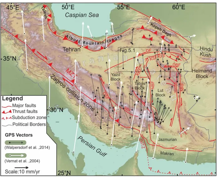
Figure 2.1 Simplified tectonic map of Iran, showing the main collisional and intraplate strike–slip fault domains accommodating the Arabia-Eurasia convergence (modified after Berberian and King, 1981). The dashed rectangle indicates the study area. DSF: Dehshir fault; KKF Kalmard-Kuhbanan Fault, KSF: Kuh-e–Sarhangi Fault; KFF Kuh-e-Faghan Fault MZT: Main Zagros Trust; NBF: Nayband Fault; NHF: Nehbandan fault; SBF: Shahr-e–Babak Fault; ZMTZ: Zagros-Makran Transfer Zone. . GPS velocities vectors in Iran relative to stable Eurasia are shown with different colors according to Vernant et al. (2004) and Walpersdorf et al. (2014);
accommodated in its intraplate domain by array of distributed strike-slip fault systems, and (ii) its arid climatic conditions, which guarantee good outcrop preservation and rock exposures. The tens to hundreds of kilometer long seismically active fault systems of intraplate Central Iran are associated
with linear mountainous ridges along which basement rocks and mid to deep crustal blokes are often exposed attesting for the capacity to exhume. Furthermore, Central Iran has a relatively well-preserved Neogene-Quaternary continental sedimentary record. Such continental sedimentary successions have been strongly influenced by structural development of the region, related to the Arabia-Eurasia collision. In particular the structurally controlled architecture and syn-depositional deformation structures of Neogene sedimentary record can be used to reconstruct its source-to-sink evolution in order to investigate the relative timing and development of intraplate deformation. Moreover, the Quaternary deposits distributions and their geomorphological characters can be used to constrain the tectonic evolution in recent geological times. The study describes the Neogene-Quaternary structural architecture, kinematics and exhumation history of the KFF system, together with its associated Neogene and Quaternary continental deposits.
Using a multidisciplinary approach that integrates, structural, stratigraphic and geomorphological field investigation, with thermochronological and geochronological analysis the study aims to investigate how the KFF systems propagate and evolve in space and time. Successively the study aims to assess how KFF system evolution relates/responded to the deformation history documented along the Iran collisional plate boundary.
Based on the new evidence this study presents a morpho-structural evolutionary model of the KFF. Such model explains 1) the structural growth evolution and spatio-temporal propagation of the KFF system, 2) the stratigraphic succession, sediment distribution and thicknesses variations of the Neogene continental deposits 3) the geomorphic signal of active tectonics in a very preservative (arid) landscape. Finally, the new finding are contextualized into their regional tectonic framework, proposing an innovative spatio-temporal evolutionary tectonic model, which explains the complex evolution and distribution of deformation in Central Iran since ~20 Ma.
These new results have important implications on understanding how natural intraplate strike-slip fault systems propagate and evolve in space and time. Furthermore it presents, for the first time, much needed direct age constraints on the deformation history of Central Iran and brings new important considerations on the Neogene-Quaternary kinematic and tectonic evolution of Central Iran and on collisional intraplate domains in general.
G. Calzolari PhD Thesis
27
3 GEOLOGICAL BACKGROUND
3.1 Regional tectonic setting
The Arabia-Eurasia collision zone is one of the largest and most spectacular examples of continental convergent deformation on Earth (Hatzfeld and Molnar, 2010). Convergence may have initiated in the mid-Jurassic (Agard et al., 2005; Agard et al., 2011) and culminated with the Arabia– Eurasia continental collision through a polyphase tectonic history: (i) onset of collision, estimated to have started at the Eocene–Oligocene boundary (e.g. Allen and Armstrong, 2008; Boulton and Robertson, 2007; Ershov et al., 2003; Hafkenscheid et al., 2006; Hessami et al., 2001; Homke et al., 2009; Homke et al., 2010; Jolivet and Faccenna, 2000; McQuarrie et al., 2003; Morley et al., 2009; Mouthereau et al., 2012; Robertson et al., 2006; Vincent et al., 2005; Vincent et al., 2007); (ii) a regional increase in collision-related uplift, exhumation, and subsidence in adjacent basins, beginning in the early Miocene, as documented by thermochronological (Axen et al., 2001; Ballato et al., 2013; Gavillot et al., 2010; Guest et al., 2006; Madanipour et al., 2013; Okay et al., 2010; Verdel et al., 2007), stratigraphic (e.g. Ballato et al., 2008; Ballato et al., 2011; Guest et al., 2006; Hessami et al., 2001; Khadivi et al., 2009; Morley et al., 2009; Mouthereau et al., 2007) and structural (e.g. Allen et al., 2004; Mouthereau et al., 2007) evidence; and (iii) a widespread tectonic reorganization during late Miocene–early Pliocene, as attested by enhanced exhumation in the Alborz and Talesh mountains (Axen et al., 2001; Madanipour et al., 2013; Rezaeian et al., 2012), fault kinematic changes in the Kopeh Dagh (Shabanian et al., 2010; Shabanian et al., 2009a; Shabanian et al., 2009b) and in the Zagros–Makran transfer zone (Regard et al., 2004; Regard et al., 2005a), which is thought to have resulted in the current regional kinematic configuration (Allen et al., 2004).
The lag-time (15-20 Ma) between phase (i) and phase (ii), has been interpreted by Ballato et al. (2011) as two-phase collisional process. During the initial, “soft” stage of continental collision, plate convergence was absorbed along the subduction zone, while a minor fraction was accommodated by the upper-plate by contractional deformation. During the second stage is inferred that, the decrease in convergence rate by 20 Ma was associated with the “hard” collision of unstretched Arabian lithosphere, which ultimately caused widespread upper-plate deformation (Ballato et al., 2011, p. 128). The evidences gathered in those studies principally come from the orogenic belts situated at the edges of the Iranian plateau (Fig. 2.1); Zagros Alborz, Kopeh Dagh and Talesh). By contrast, little is known about the deformation history of the intraplate domain of Central Iran.
3.2 Central Iran
The Central Iran Micro Continent (CIMC) consists of an amalgamation of continental blocks bordered by topographically prominent mountain ranges, comprising the Kopeh Dagh, Alborz and Talesh orogenic belts to the north, and the Zagros orogenic belt and Makran active subduction related complex to the north-west and south (Fig 2.1). In particular, the CIMC includes the Lut, Tabas, and Yazd microblocks (Aghanabati, 2004), which are bounded by linear mountain-belts developed along major strike-slip fault zones that have peculiar stratigraphy, deformation style and pattern of recent seismicity (Berberian, 2014; Berberian and King, 1981).
The GPS displacement vectors indicate a NNE motion of the Arabian plate relative to Eurasia of ~25 mm yr-1 at the longitude of eastern Iran(McClusky et al., 2003; Reilinger et al., 2006; e.g. Sella et al., 2002; Vernant et al., 2004; Walpersdorf et al., 2014). Such convergence is mostly absorbed in the orogenic terrains through contractional deformation (Zagros, Alborz, Kopeh Dagh and Talesh in the north) Fig 2.1).The CIMC is moving northward at 6–13 mm/yr with respect to the stable Afghan crust at the eastern edge of the collision zone (Walpersdorf et al., 2014). Such differential motion is accommodate by distributed N-S oriented right-lateral strike-slip faults and E-W oriented left-lateral and right-lateral strike-slip faults. GPS studies determined there current slip rates (Fig. 2.1, from east to west, data Walpersdorf et al. (2014)): the Nehbandan fault (NHF) 5.6 ± 0.6 mmyr-1, Nayband Fault (NBF) 4.4 ± 0.4 mmyr-1, Kalmard-Kuhbanan Fault (KKF) 3.6 ± 1.3 mmyr -1, Dehshir fault (DS) 1.4 ± 0.9 mmyr-1 and Doruneh faults (DF), 1.3 ± 0.8 mmyr-1 (Walpersdorf et al.,
2014).
A large number of studies have detailed kinematics and total cumulative shear along the active strike-slip faults systems of Central Iran, organized into N-S dextral (from west to east: the Deshir, Anar, Nayband–Gowk, and Nehbandan faults) and E–W sinistral (from north to south: Doruneh and Dasht-e Bayaz faults) shears (Fig. 2.1). Several studies estimated the total cumulative shear along the active strike-slip faults systems of Central Iran, using geologic and geomorphic displaced markers from satellite imagery (Allen et al., 2004; Allen et al., 2011; Farbod et al., 2011; Walker and Jackson, 2004). Taking into account the present-day slip rates (~2-10 mm/yr) along the major fault systems, the onset of strike-slip tectonics is inferred to date back to ~5 Ma (Allen et al., 2004). This shear pattern is inferred to be accompanied by diffuse rigid block rotation and strain partitioning during ongoing Arabia-Eurasia convergence (Allen et al., 2011; Farbod et al., 2011; Fattahi et al., 2007; Jackson and McKenzie, 1984; Walker and Jackson, 2004; Walker et al., 2004; Walker and Khatib, 2006). The analogue modelling results presented in Bonini et al. (2003) show that the deformation pattern within the Iranian Plateau is compatible with partitioning of the N-directed Arabia indentation into a composite system of: (i) collision-oblique seismogenetic belts, with two main conjugate
G. Calzolari PhD Thesis
29
transpressive belts (the dextral NW– SE-trending Zagros belt and the NE– SW-trending sinistral Alborz-Aran-Torud belt) and (ii) collision-parallel seismogenetic belts, in central Iran, with a modest lateral escape of the Yazd and Tabas Block towards the Lut block along the Nayband Fault (Fig. 2.1), without the need of rigid block rotation. Significant, post-Miocene counter clockwise rotation (25-35°) has only been documented in the Lut and Tabas block, whereas no significant rotation has been detected north of the Doruneh Fault (Mattei et al., 2012).
In a recent study, Nozaem et al. (2013) documented important post-Neogene to Quaternary right-lateral strike-slip tectonics along the Kuh-e–Sarhangi Fault on north western edge of the Lut block (Fig. 2.1), less than 40 km south of the sub-parallel, active left-lateral Doruneh Fault (Farbod et al., 2011; Fattahi et al., 2007; Tchalenko et al., 1973). This post-Neogene faulting is proposed to have occurred due to the tectonic reactivation of the north-eastward prosecution of the late Neoproterozoic to early Paleozoic Kashmar–Kerman Tectonic Zone (Fig. 2.1; Ramezani and Tucker, 2003; Rossetti et al., 2014) in response to a kinematically induced stress field scenario (Nozaem et al., 2013). Similarly, Javadi et al. (2013) documented a polyphase kinematic history for the Doruneh Fault, with a major change from right- to left-lateral during the late Miocene-early Pliocene times. Furthermore, Farbod et al. (2011) suggested that the complex kinematic configuration of Central Iran may be due to kinematically induced spatial variation in the stress field orientation.
3.3 The study area
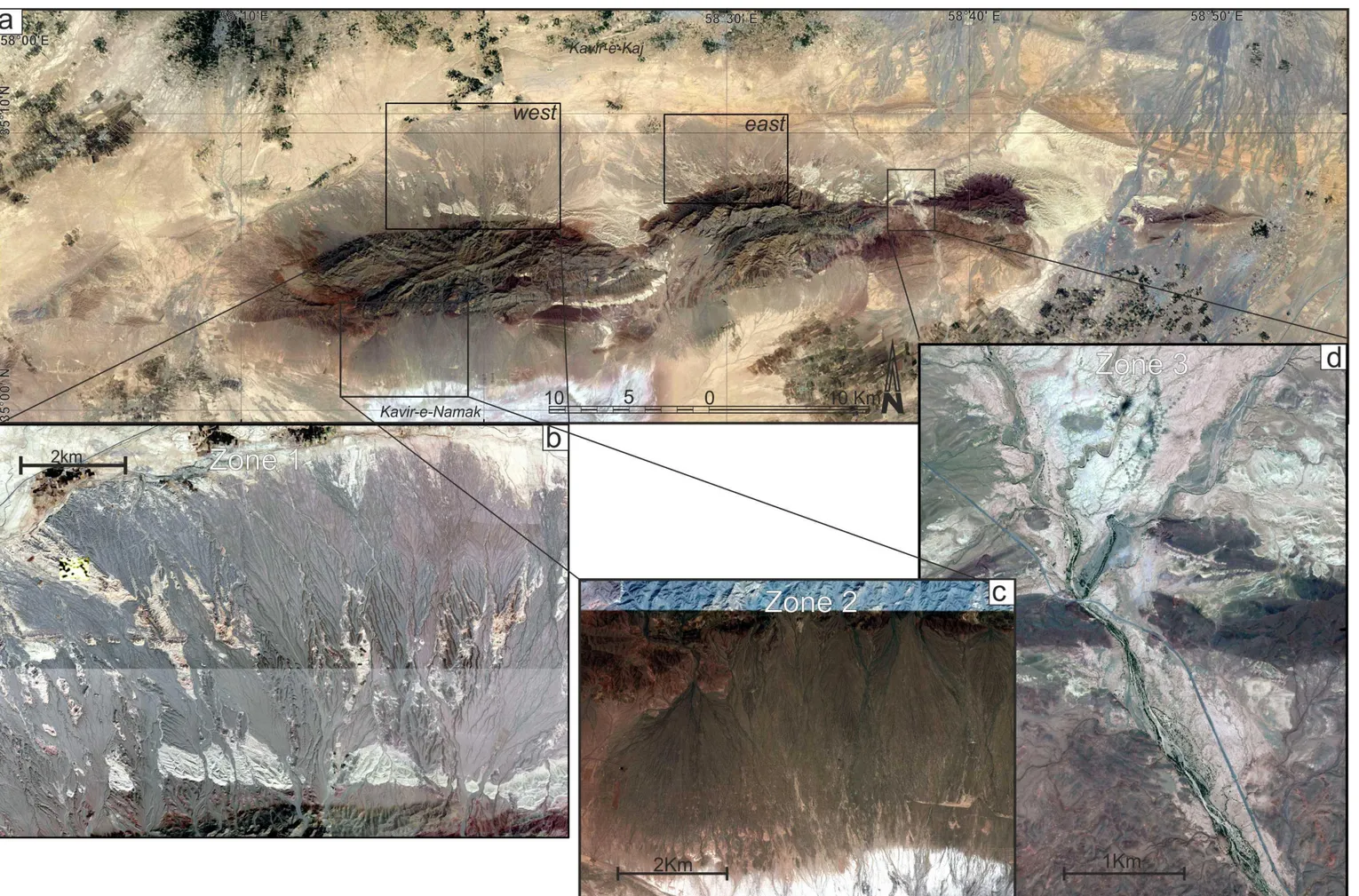
The study focuses on a linear mountainous ridge (~80 km long and ~10 km wide; maximum elevation of ~1700 m), associated with the E-W oriented Kuh-e-Faghan Fault (KFF, Fig. 2.1, 4.1). This fault system truncates the northern termination of the Kuh-e–Sarhangi fault system (Nozaem et al., 2013) and is located 25 km south of the Doruneh Fault, extending eastward for ca. 80 km (Fig. 4.1). The KFF system and the surrounding areas are seismically active (Fig. 4.1) , with maximum-recorded magnitude between 4 and 5.5 and the focal depths <35 km (Farbod et al., 2011).
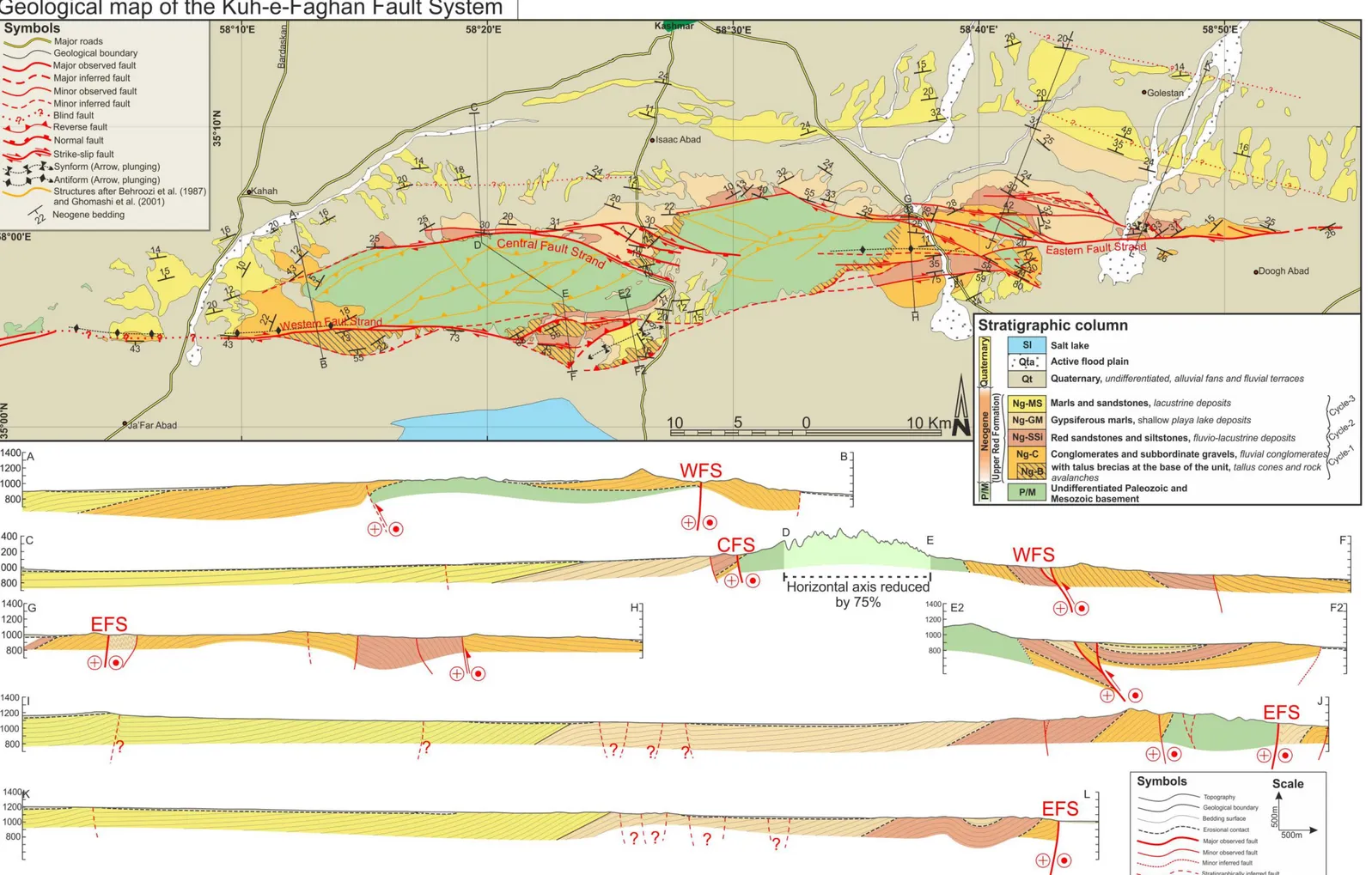
The KFF consists of E-W oriented brittle deformation zone, which cuts through pre-Neogene units (Paleozoic-Mesozoic carbonate and subordinate shale and arenitic deposits) and the unconformably overlying Neogene and Quaternary continental sequences (Behroozi et al., 1987; Eftekhar-Nezhad et al., 1976; Ghomashi et al., 2001; Jalilian et al., 1992). Fault kinematics along the KFF is poorly described, with strike-slip (Behroozi et al., 1987; Eftekhar-Nezhad et al., 1976; Ghomashi et al., 2001; Jalilian et al., 1992) vs. reverse (Hassami et al., 2003; Javadi et al., 2013) kinematics proposed so far.
The basement units exhibit a steeply-dipping ENE-WSW oriented planar fabric, also reported from the neighbouring e-Sarhanghi Fault system (Nozaem et al., 2013). Conversely to the Kuh-e-Sarhan Fault, where the post-Neogene deformation has exploited the regional fabric, reactivating
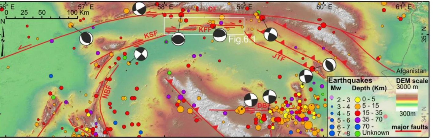
Figure 4.1 Simplified tectonic map of northern Central Iran, showing the historical and instrumental
seismicity of the area. Focal mechanisms are taken from the Harvard catalog
(http://www.globalcmt.org/CMTsearch.html). Epicentres are from the ISC EHB Bulletin (International Seismic Centre, Thatcham, United Kingdom, 2009, http://www.isc.ac.uk) and earthquake catalogue at Iranian Institute of Earthquake Engineering and Seismology;http://www.iiees.ac.ir. The white square indicates the location of the study area and the extent of the maps in figure 6.1.
the inherited structures (Nozaem et al., 2013), in the KFF the Neogene Quaternary deformation cuts across the ENE-WSW trending regional fabric and does not seem to exploit any pre-existing structure. Despite contrasting stratigraphic scenarios have been assigned to the Neogene successions, previous paleogeographic and sedimentological studies (Amini, 1997; Berberian and King, 1981) refer the Neogene deposits alongside the KFF to the Upper Red Formation of Central Iran. The Upper Red Formation is the first continental sequence above the marine, late Oligocene–middle Miocene Qom Formation (Ballato et al., 2008; Berberian, 1974; Daneshian and Dana, 2007; Hadavi et al., 2010) and consists of conglomerates, sandstones, siltstones, marls end evaporites (Amini, 1997; Ballato et al., 2008; Ballato et al., 2011; Morley et al., 2009). Due to the lack of biostratigraphical markers or radiometrically datable units, the age and duration of the Upper Red Formation are not well constrained. Based on the magnetostratigraphic study of the Eyvanekey section in southern Alborz Mountains, Ballato et al. (2008) proposed a Burdigalian to Tortonian (17.5-7.5 Ma) age.
Quaternary successions, made of alluvial fans and terraced alluvial plain deposits, unconformably overly the Neogene units. The stratigraphy of the alluvial deposits of the KFF region has not been studied yet. Walker and Fattahi (2011) reviewed the late Quaternary deposits of eastern Iran. The authors recognized that several generations of telescopic alluvial fans, as well as regional arrangement of river terraces and lake deposits could be explained by Late Pleistocene and Holocene environmental changes with aggradation phases occurring between ~30 and 13 ka and between ~9 and 7 ka, alternating with erosive phases, controlled by regional climatic forcing. As for the erosive phases, in-situ produced cosmogenic 10Be provided surface abandonment ages for different Quaternary alluvial surfaces in the the Hormoz Strait area at 5.6±0.6, 8.4±1.0, 12.8±1.0, 20.1±1.5,