PAPER • OPEN ACCESS
3D numerical analyses for the quantitative risk
assessment of subsidence and water flood due to
the partial collapse of an abandoned gypsum
mine.
To cite this article: R Castellanza et al 2015 IOP Conf. Ser.: Earth Environ. Sci. 26 012058
View the article online for updates and enhancements.
Related content
Physicochemical methods for enhancing oil recovery from oil fields
L K Altunina and V A Kuvshinov
-Investigation on Mechanisms of Polymer Enhanced Oil Recovery by Nuclear Magnetic Resonance and Microscopic Theoretical Analysis
Zhang Ji-Cheng, Song Kao-Ping, Liu Li et al.
-A Framework for Remote Monitoring System
Cahyo Crysdian
3D numerical analyses for the quantitative risk assessment of
subsidence and water flood due to the partial collapse of an
abandoned gypsum mine.
R. Castellanza1, G.M. Orlandi2, C.di Prisco3, G. Frigerio3, L. Flessati3, J.A.
Fernandez Merodo4, F. Agliardi1, S. Grisi1, G. B. Crosta1
1DISAT – Università di Milano Bicocca, [email protected] 2Studio Associato di Geologia Spada, Ranica (BG) [email protected] 3DICA – Politecnico di Milano, [email protected]
4Universidad Politécnica de Madrid – IGME Madrid, [email protected]
Abstract. After the abandonment occurred in the '70s, the mining system (rooms and pillars)
located in S. Lazzaro di Savena (BO, Italy) , grown on three levels with the method rooms and pillars, has been progressively more and more affected by degradation processes due to water infiltration. The mine is located underneath a residential area causing significant concern to the local municipality. On the basis of in situ surveys, laboratory and in situ geomechanical tests, some critical scenarios were adopted in the analyses to simulate the progressive collapse of pillars and of roofs in the most critical sectors of the mine. A first set of numerical analyses using 3D geotechnical FEM codes were performed to predict the extension of the subsidence area and its interaction with buildings. Secondly 3D CFD analyses were used to evaluated the amount of water that could be eventually ejected outside the mine and eventually flooding the downstream village. The predicted extension of the subsidence area together with the predicted amount of the ejected water have been used to design possible remedial measurements.
1. Introduction
Aim of this study is the assessment of stability conditions for an abandoned gypsum mine located in San Lazzaro di Savena (Bologna, Italy). Mining was carried out until the end of the 70s by room and pillar method (Figure 1). During mining, a karst cave was crossed bringing karstic water to infiltrate into the mine. As a consequence, the lower level of the mining is now completely flooded and portions of the mining levels show critical conditions and are structurally prone to instability. Buildings and infrastructures are located above the first (L1) and second (L2) levels and a large portion of the area downstream the mine, just above Savena river, is urbanised.
Gypsum geomechanical properties change over time; water, or even air humidity, dissolves or weakens gypsum pillars, leading progressively to collapse. The mine is located in macro-crystalline gypsum beds belonging to the Messinian Gessoso Solfifera Formation. Selenitic gypsum beds are interlayered by centimetre to meter thick shales layers. In order to evaluate the risk related to the collapse of the flooded level 3 (L3) a deterministic approach based on 3D numerical analyses has been considered. The entire abandoned mine system up to the ground surface has been generated in a 3D model. The considered critical scenario implies the collapse of the pillars and roof of the flooded level 3.
In a first step, a sequential collapse starting from the most critical pillar has been simulated by means of a 3D Finite Element code. This allowed the definition of the subsidence basin at the ground surface and the interaction with the buildings in terms of ground displacements. 3D numerical analyses have been performed with an elasto-perfectly plastic constitutive model.
In a second step, the effect of a simultaneous collapse of the entire L3 has been considered in order to evaluate the risk of a flooding due to water outflow from the mine system. Using a 3D CFD (Continuum Fluid Dynamics) finite element code the collapse of L3 level has been simulated and the volume of outflowing water has been quantified together with water velocity and pressure. On the basis of the results, remediation measures have been defined and the risk has been evaluated with a deterministic approach. Level L1 Level L2 Level L3 fine soil
thin shale layers
gypsum rock 0 100m 200m 100m 70m 130m Borehole 2 Borehole 1 water water
Figure 1. Views of the abandoned gypsum mine system and schematic section. 2. Geomechanical characterization of gypsum including weathering effects
To evaluate the effects of weathering processes caused by water on the mechanical behavior of gypsum a specific experimental campaign was designated. Performing a series of uniaxial compression tests on cores extracted at different depth, it was possible to measure a value of the compressive strength (UCS). The material in dry conditions exhibited a compressive strength of about 12 MPa; the strength reduced to 7 MPa when the material was taken from the roofs of L1 and L2 levels as it was affected by conditions of saturate humid air (Hr 100%) and it resulted 5 MPa for the gypsum of L3 level, as it was immersed in water.
In addition to UCS tests indirect tensile and triaxial tests have been performed. Subsequently a series of small scale experimental tests on cylindrical pillars simultaneously loaded and immersed in a water flow were performed. In Figure 3a, similarly to what presented in Castellanza et al. (2010), it is
shown a test carried out on a sample with an axial load of 4 MPa (representative of the conditions of the site of pillars) that reaches failure after 9 days from the immersion in a water flow.
Laboratory tests (UCS, BT, Triax)
Axial strainea[-] Ax ia l s tre s s s a [M p a ]
UCS test Triaxial multistage tests
Hoek&Brown Failure loci
Ax ia l, R a d ia l s tre s s s a [M p a ]
Axial strainea[-] s3[MPa]
s1
[k
Pa
]
Figure 2 Geomechanical characterization in the laboratory: standard tests (UCS, BT, Triaxial tests). Finally a series of uniaxial compression tests on specimens degraded by immersion in water at different time both in laboratory and in situ is shown in Figure 3b. It shows the reduction in UCS strength for specimens immerged in situ in the water at L3 level for times longer than 300 days. Laboratory tests: pillar collapse
Set
tlem
ent
[mm]
Time [days] start of water flux
0 2 4 6 8 10 12 0 50 100 150 200 250 300 350 R e s is te n z a m o n o a s s ia le [ M P a ] Tempo (giorni) Serie1 Serie2 Serie3 U n ia xi a l st tre n g th st re ss s a [Mp a ] Time [days]
In situ Weathering Tests
0 2 4 6 8 10 12 0 50 100 150 200 250 300 350 R e s is te n z a m o n o a s s ia le [M P a ] Tempo (giorni) Serie1 Serie2 Serie3 a) b)
Figure 3. a) Small-scale simulation of collapse of a pillar in a water flux , b) Decay resistance to uniaxial specimens immersed in situ (the flooded quarry).
The experimental tests carried out allowed to define the parameter of the Hoek&Brown criteria for rock masses (1997). As visible in Figure 2 the Hoek and Brown yield surface shrinks as weathering proceeds in the different levels of the abandoned mine. The minimum strength is associated to the flooded L3 level.
3. Estimation of the subsidence area with 3D FEM non linear analyses
The next step was to create a detailed three-dimensional model of the entire system, including the geometric elements (external topography, location buildings and infrastructure, mining plan levels) and those related to the geomechanical characterization of materials and their distribution (figure. 4). Numerical modelling has been developed with non-linear FEM code Midas GTS. Initially a series of preliminary assessments to verify the pillar stability were performed using the method proposed by Obert & Duvall (1967) . The in situ stresses of each pillar were evaluated by the 3D numerical analyses.
Current stability conditions
Fattore di Sicurezza
Pillar plastc strains Pillar Safety Factor
current Fs 0.8 0.9 1.0 1.1 1.2 1.3 1.4 1.5 1.6 1.7 1 2 3 4 5 6 8 9 17 pilastri L3 Fs Vertical stress
Figure 4. Assessment of current conditions of stability of the pillars by the method of Obert&Duvall and non-linear FEM analysis.
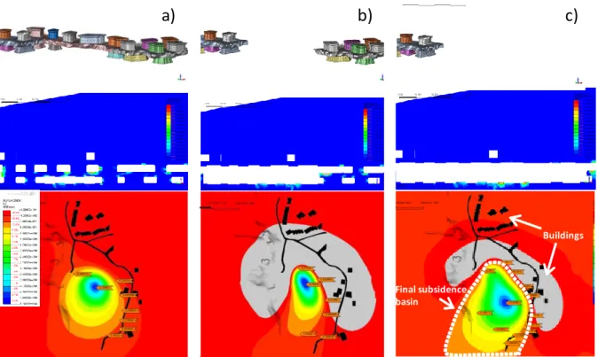
Final subsidence basin
Buildings
a)
b)
c)
Figure 5. Simulation of the progressive collapse (a, b, c) of the pillars of the lower flooded level (L3) and the corresponding intermediate level (L2) with prediction of subsidence induced at the surface in relation to the existing buildings.
Using this approach the most critical situations were identified. They are represented by a series of pillars in the lower L3 level, characterized by a safety factor close to unity (Figure 4) and by significant plastic strains. Next, using a procedure of excavation for phases, the pillars of L3 level and the roof of the intermediate L3/L2 level were progressively removed (Figure 5a,b,c). In this way the numerical model was used to estimate the basin of subsidence at the surface (Figure 5). The numerical analyses reveal that even in case of collapse of all the L3 level pillars, the system is able to maintain equilibrium and convergence. A sort of large underground tunnel with a diameter of about 20m will be created when the pillar of L3 will be remove. Nevertheless the upper levels (L2 and L1) does not fails.
In this scenario of progressive removal of pillars and portion of roof, a subsidence basin is predicted in terms of vertical settlements. Since it not affect directly the buildings and the infrastructure (Figure 5c) it has been concluded that the risk related to the failure of all the flooded pillars at L3 level is very low.
4. 3D Numerical estimation of flooding due to impulsive water outflow from the mine.
In this section the 3D numerical results of water flooding induced by the collapse of critical pillar and roof portions inside L3 and L2 levels is presented. More than 80.000m3 are now flooding L3 level;
consequently the goal of this analysis is to quantify the outflow water that in case of catastrophic scenario can rise from L3 level to L1 level. This water could proceed towards the urbanized area around the gypsum mine inducing flooding.
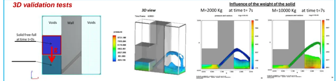
3D CFD analyses have been performed with FLOW 3D. In Figure 6 a preliminary numerical test is reported. The main aspects required in the simulation are: i) Advanced Surface Modelling Fluid TruVOF (technical volumes of fluids), ii) viscous flow of water subject to the gravitative action, iii) turbulence model laminar; iv) friction coefficient for shear wall boundary conditions.
Influence of the weight of the solid
M=2000 Kg at time t= 7s M=10000 Kg at time t=7s Solid free-fall at time t=0s Wall Voids Voids g 3D validation tests
Figure 6. Preliminary tests for the validation of the conceptual 3D CFD model.
Catastrophic scenario:
Simultaneous collapse of the entire lowest level (Level 3): volume130 000 m3
23 kN/m3
weight39N (pressure acting on the incompressible fluid)
Reservoirs in the upper (simulate system access mining)
Reservoir in the middle tier (simulating the discharge pipe of "overflow")
3D model scenario
Concerning the Fluid-Structure Interaction a moving objects has been adopted to simulate the collapse of the slab between the second and third levels. The modelling of the hydraulic behaviour of a fluid volume (volume of water stored in the lower level of the quarry) subjected to a pressure (derived from the collapse of a certain portion of the mining system) was initially sketched and validated through simple models two and three dimensional (figure 6). In a finite domain, a volume of incompressible fluid comes to lie below a solid characterized by a certain density, initially bound (in equilibrium). Leaving the solid free from the constraints, it tends to move in a free fall due to gravity, causing a pressure increase in the fluid volume, which in turn has the possibility to move thanks to the presence of connections with expansion chambers (tunnels and wells that connect the mining flooded level with the level above, not flooded). The catastrophic scenario built in 3D, for this mine is shown in Figure 7. It was decided to consider a further unfavourable condition which is the simultaneous collapse the entire roof of L3 level to maximize the impact of the falling down gypsum mass on the volume of water present in mine.
Acqua esondata da L1 Tappo L2
Figure 8. Forecast flooding volume of water (instant collapse - catastrophic scenario)
The results are shown for different time intervals in Figure 8. It could be shown that the analysis revealed the internal buffering capacity of the intact portion of the L2 (figure 8). Furthermore, the analysis allowed to assess the volume and the velocity of the water that can flood out from L1 level towards the urbanized area. The estimated values of the flooding water is about 2000 m3. It represent
approximately the 2% of the water that flood the mine. This amount is compatible with small channelling works to bring this water in the Savena River located just outside the mine. The forecasting of flooding water reveal again a low risk for the urbanized area
5. Conclusion
Numerical analysis performed, characterized by an accurate three-dimensional modelling, enable to assess the effects of the collapse of L3 level both in terms of subsidence basin and volume of flooding water. These effects were considered negligible in terms of interaction with urban areas resting below and above the considered abandoned mine. Therefore, these results were used for a better planning
that lies in the absence of relevant remediational measures for L3 level. In fact, even in case of extremely critical scenarios for L3 level no significant risk of citizens living close this abandoned mine. The decommissioning of the mine was consequently efficiently focused on L1 and L2 levels.
The main efforts are now concentrated to increase the strength of the pillars located at L1 and L2 levels that directly interact with buildings.
6. References
[1] Castellanza R., Nova R., Orlandi G. (2010), Flooded gypsum mine remedial by chamber filling,
Journal of Geotechnical and Geoenvironmental Engineering ASCE Vol. 136(4), pp. 629-639,
DOI: 10.1061• ASCE GT.1943-5606.0000249.
[2] Hoek, E., and E. T. Brown (1997). Practical estimates of rock mass strength. International Journal
of Rock Mechanics and Mining Sciences 34.8: 1165-1186.