G.I.S. & URBAN DESIGN #11 - aprile 2013
ISSN 1828-5961
DISEGNARECON
Camila Marques Zyngier Laureata in Architettura ed Urbanisti-ca, frequenta il Dottorato di Ricerca presso la Facoltà di Architettura dell’U-niversità Federale di Minas Gerais (UFMG). Docente di Urban Design per il corso di Architettura nell’ambito del Programma CAPES-REUNI. Docente presso il Methodist Istituto Izabela Hendrix, scuola di Architettura e Ur-banistica. Dal 2010 è titolare di uno studio di architettura. Ha esperienza nelle applicazioni di GIS per l’analisi e la pianificazione urbana.
I paesaggi urbani sono risultati di trasformazio-ni che si verificano in diverse scale temporali e spaziali. Considerando un ampio lasso di tempo, risultano condizionati dalle norme di utilizzo del suolo che determinano la configurazione dei volu-mi che formano un insieme complesso. In un lasso di tempo breve sono trasformazioni pià precise, come interventi chirurgici. Tenendo conto di que-ste osservazioni, in questa ricerca si sono sollevate due questioni: una comunità – che vive, osserva e costruisce in un paesaggio – é in grado di com-prendere e approvare una nuova configurazione spaziale, risultante da norme sugli interventi? E’ possibile , nella pianificazione urbana, contri-buire, in qualsiasi modo, a guidare il modello di trasformazione implicato nelle norme? E qual è lo stato dell’arte di queste trasformazioni, soprat-tutto per i cambiamenti promossi dalla gestione urbana derivanti dalla normative urbanistica?
Obiettivo di questo contributo può quindi essere riassunto dalla domanda: Come sono comunica-te le pocomunica-tenzialità di costruzione di un paesaggio urbano adeguato, prodotto dell’applicazione di norme?
Nella ricerca sono state prese a campione due realtà territoriali, come aree pilota, analizzando analogie e differenze al fine di chiarire il quesito proposto.
When considering a wider time scale, urban lan-dscapes are the result of applying land use poli-cies. In a shorter time scale, urban interventions are transformations stirred by entrepreneurism. Considering these observations about how for-mally planned landscapes are produced, a few questions are raised: can a community under-stand, accompany and approve a new spatial configuration, transformed by interventions and
Paesaggi possibili nelle norme: come sono progettati e comunicati?
Possible landscapes in norms: how are they designed and communicated?
Parole chiave: geoprocessing; gestione dei paesaggi; comunicazione dei parametri urbanistici
Keywords: landscape management; urban
parameters communication
controls? Is it possible to contribute towards ur-ban managements, promoting the science behind proposals and possibilities within the norms which model a landscape? From these inquiries, a main question sums up: How the possibilities which involve a designed urban landscape are communicated? Two pilot areas are going to aid this investigation, regarding their similarities and differences.
122 #11 - aprile 2013
ISSN 1828-5961
DISEGNARECON
Paesaggi possibili nelle norme: come sono progettati e comunicati? Zyngier G.I.S. & URBAN DESIGN
INTRODUCTION
Urban landscapes are the result of transformations which occur in different time and space scales. When considering a wider time scale, landscapes are the result of applying norms of land use and occupancy, configuring punctual volumes which form, when added together, a complex whole. In a shorter time scale, urban interventions are transformations as precise as surgeries, stirred by entrepreneurism. Considering these observations about how formally planned landscapes are formed, a few questions are raised, motivating this investigation: can a community – which inhabits, observes and constructs in any given landscape –understand, accompany and approve a new spatial configuration, transformed by interventions and controls? Is it possible to contribute, in any way, towards urban managements, promoting the science behind proposals and possibilities within the norms which model a landscape? What is the state-of-the-art of these transformations, especially in the changes promoted by urban management resulting from legislations?
From these initial inquiries, a main question sums up the aim of this paper: How the possibilities
which involve a designed urban landscape are communicated? It is true that there are official
mechanisms for urban landscape modeling, through norms; on the other hand, there are also other acting agents, such as, in private sectors, entrepreneurs (Harvey, 1994).
Therefore, there is a resulting need to analyze case studies in order to elucidate our guiding question. Two territorial realities, here called
pilot areas, are going to aid this investigation,
regarding their similarities and differences, building a diverse comparative table.
PILOT AREAS
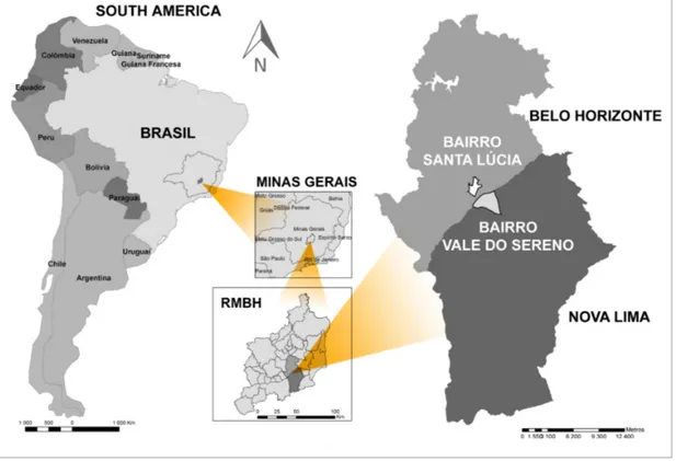
Both pilot areas selected for this analyzes present great relevance for the Metropolitan Region of Belo Horizonte (MRBH), in different and even contradictory levels: Santa Lúcia (municipality of Belo Horizonte) and the neighborhood Vale do
Sereno (Nova Lima municipality) (Figure 1). A factor which justified pilot areas selection was data availability, which was also fundamental in implementing techniques of spatial information treatment, and supported the study of the elected urban landscapes.
These areas correspond to different municipalities and, therefore, they result from different urban parameters and forms of land occupancy. Also, both mentioned municipalities present very different political and social realities, one of which
being the state capital and third largest Brazilian metropolis (Belo Horizonte), and the other being a municipality of recent and fast transformations, resulting from the capital’s growth (Nova Lima). Both municipalities present distinct histories and experiences of community participation in urban management and planning. Despite all differences, in physical terms, the neighborhoods selected are very similar, because they are morphologically they are located in valleys which resemble amphitheaters and are situated in the
123 #11 - aprile 2013
ISSN 1828-5961
DISEGNARECON
Paesaggi possibili nelle norme: come sono progettati e comunicati? Zyngier G.I.S. & URBAN DESIGN
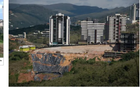
fringes of the Curral mountain range (Figure 2). Chosen areas present great importance for the Metropolitan Region of Belo Horizonte’s environment, since they are contiguous to woods and springs, as well as presenting relative contradictions regarding their use and legislation versus real-estate interests (Gomes, 2006). In this frontier zone (Rodrigues, 2001), or else,
line of fire (Gomes, 2006), under a great deal
of pressure, the Jambreiro woods, Ecological Station of Cercadinho, and the intensification of anthropic interventions are combined. The landscapes selected contain more consolidated occupancy as well as others in amongst a process of urban transition, which are targets for entrepreneurs and environmental interest,
in different proportions and distinct moments (Figure 3).
LAYERS OF A PALIMPSEST
The methodology is planned to be applied in two scales of palimpsest investigation (see footnote 1): the neighborhood scale, whose analysis is developed through thematic mapping, comparison and combination of variables, using Geographic Information System (GIS) and geoprocessing models; and the edification volumes’ scale, studied through tridimensional representation of proposed urban parameters, forming templates regarding the maximum permitted by norms.
GIS (Geographic Information System) tools were used initially for composing data collections on an area and for georeferencing historical maps (Figure 4). Once the data collection is structured, the historical maps were compared in a way to comprehend the temporal and spatial evolution of the legislation’s estimate. Other then the map comparison, geoprocessing allowed for variable combination by a spatial analysis method untitled Multicriteria Analysis, in order to indentify vocations and conflicts of interest (Figure 5). Regarding the analysis undertaken to plot occupancy scale, taking into account urban parameters which define maximum limits for occupancy, the first step was to gather all published material with reference to norms,
124 #11 - aprile 2013
ISSN 1828-5961
DISEGNARECON
Paesaggi possibili nelle norme: come sono progettati e comunicati? Zyngier G.I.S. & URBAN DESIGN
which are Master Plans (municipal development plan) and Decrees, relative to reference changes for the areas studied. All material is presented, as most Master Plans made for Brazilian cities, in the form of texts, tables, and, at best, zoning maps.
Even considering the great amount of available materials, it was noted that this resource was not sufficient for a user to create an image of the future’s possible landscape. When facing the norms’ informative inefficiency in communicating the possible landscapes’ outcome from urban parameters, a great effort in producing tridimensional images was undertaken, with the aim of translating to a lay, a possible effect of applying regulations. It is believed that even
professionals from the fields of architecture and urbanism would have difficulties predicting the outcomes in a landscapes’ whole, once urban regulations are applied.
In order to aid norm reinterpretation into images and their possible outcomes into pilot areas, this research investigated and modeled
templates (Figure 6, Figure 7, and Figure 8).
These templates resulted from decoding and spatializing urban parameters established for pilot areas, through tridimensional modeling, created from maximum feasible building and their respective plot settlements, which also have their size determined by norms. The conjoint of these units was organizes in a table (Figure 8). Its interpretation was used as a reference for a
wider historical analysis, regarding identification of periods of building construction, as well as for creating a present portrait of the layers which integrate the pilot areas’ landscape palimpsest. Several comparative tables were created, such as the one below, offered as an example (Figure 8). These tables allow for a spatial representation of several data previously presented only as a norm text.
It is important to bring out that the generated forms show only a few possible configurations the parameters used allow for and that, obviously, there are other ones. The presentation of only one of its possible applications effectively demonstrates how important it is that population in general visualizes adequately projected
125 #11 - aprile 2013
ISSN 1828-5961
DISEGNARECON
Paesaggi possibili nelle norme: come sono progettati e comunicati? Zyngier G.I.S. & URBAN DESIGN
landscapes, and, hence is enabled to act as a transformation agent and properly manage their lived landscapes.
Therefore, the use of photographs as often as possible is recommended, so to illustrate a few variables generated by parameters (Figure 9). The methodological script proposed by this research aimed to identify ways to undertake urban analysis presenting greater communication power amongst users, from the stage of characterization to the diagnostic stages, such as prognostic and proposition, thus favoring communities critically following up management decisions.
POSSIBLE LANDSCAPES WITHIN PILOT AREAS: PRESENT PORTRAIT OF A PALIMPSEST
From using envelops as references, a register was created detailing all layers presently composing urban landscapes projected within neighborhoods Vale do Sereno and Santa Lúcia. In Santa Lúcia neighborhood, landscape is constituted by: (a) vacant areas and incomplete street layouts, many of which belong to the neighborhood’s original layout; (b) 3 to 4 pavements buildings (with the exceptions reaching up to 10 pavements), constructed in a period of pre-LUOS (LLUO - Laws of Land Use and Occupancy) norms 2.662/1976; (c) single family residences, of several typologies and constructions from the period previous to LUOS
(LLUO) 1976 and to the neighborhood’s beginning up to present day, since there are constructions of this category ongoing in 2012; (d) horizontal multifamily residences of recent construction; (e) vertical multifamily buildings, with several pavements, resulting from norms issued from LUOS 7.166/1996 and the accumulation of quotes
by habitation units, therefore implemented in
several gathered plots; (f) mixed and diverse use edifications, such as offices and galleries, also resulting from norms issued from LLUOS 1996 (Laws of Land Use and Occupancy); (g) consolidated verticalization throughout the Raja Gabaglia Ave track and in parts of BR356; (h) areas undergoing approval evaluations for hotels and edifications related to municipal permits
Figure 6 – Example of a tridimensional model format. Source: Zyngier 2012.
126 #11 - aprile 2013
ISSN 1828-5961
DISEGNARECON
Paesaggi possibili nelle norme: come sono progettati e comunicati? Zyngier G.I.S. & URBAN DESIGN
(ADE’s, Law number 9.952 of July 5th of 2010
and decree number 14.353 of April 6th of 2011),
considering the World Cup which will take place in Brazil, 2014 (Figure 10).
Conversely, Vale do Sereno neighborhood has its present landscape constituted by: (a) vacant areas covered by extensive vegetation; (b) large towers of mixed use, commercial and residential, in models of occupancy derived mainly from alterations promoted by 1993 to 1996 norms; (c) single family residential edifications, probably
built between 1993-1996 and with characteristics compatible to the original intended land plot division (approved in the 1980’s); (d) a few examples of edifications originally intended to be single family residences, but which today hold functions related to constructers acting on the region; (e) other outnumbered typologies, such as children schools or foundation head office (Figure 11 and Figure 12).
Thinking on pedestrian scale, the final result of
all analyzed palimpsest’s layers in the Vale do Sereno neighborhood is the perception of several
blind walls conformed by pavement volumes on constructed area non computable, those destined
to towers’ garages and parking volumes. The cell formed by this projected landscape is allowed by the projects’ template authorized by the 2007 Master Plan and which, in most cases (see footnote 2), corresponds to a volume similar to a tower supported by a tray (Figure 12).
In the Vale do Sereno neighborhood, relations
Figure 8 – Example of a comparative study on possible templates which constitute a projected landscape, in Vale do Sereno neighborhood. Source: Zyngier 2012.
Figure 9 – Example of a tridimensional model format, associated to images possibly configuring template within pilot areas landscape (Santa Lúcia neighborhood). Source: Zyngier 2012.
127 #11 - aprile 2013
ISSN 1828-5961
DISEGNARECON
Paesaggi possibili nelle norme: come sono progettati e comunicati? Zyngier G.I.S. & URBAN DESIGN
between topography and volumes generated by terrain corrections hold great influence on resulting layers. Generally, its volumetric is given by a great tower supported by a volume shaped as a tray. This tray results from a normative permit, still in force, establishing that the volume’s area, usually destined to parking, is not computed in the constructive area. From an economical demand, thus emerge esthetical(footnote 3) patterns which influence directly the perception of public space. The trays generate large blind walls (Figure 12), facing the road in with garages and even empty areas are located, when these closings serve to cover visible pillars resulting from large structures supporting towers.
Considering observations noted in the two pilot areas here considered, it was perceived intense
duality between public and private spaces. There is no gradation, since interval spaces do not exist between public and private, defined by Hertzberger (1999, p. 36) as fundamental to the process of joining dimensions. As a consequence, an empty condition and a residual situation are noted.
In the case of Santa Lúcia neighborhood, spaces dedicated to squares, places of essentially public life, do not offer coexistence or promote meeting conditions, since they are consequences or surpluses from street layout (Zyngier, 2012). In Vale do Sereno, on the other hand, streets public spaces referenced as a collective environment, regarding Lefebvre’s Festival (footnote 4) and relations transfer, call for the life which animates them.
Largely in pilot areas, however, public spaces lack urban design actions integrating and qualifying them. This lack of integration, according to Senra (2011) promotes intellectual, professional and functional separations, representing a step back. It would be the extinction of life and the extreme functionalization of existence, pointed out by Lefebvre.
It was observed, in field trips, that Santa Lúcia and Vale do Sereno present a potential for incorporating land plots, which means buying smaller and contiguous plots and soliciting single use, for constructing larger buildings. Also, in both neighborhoods, the matter of opening norm precedents for neighborhoods in their vicinities is also relevant. This influence was a process catalyzed by the expansion of reference centers,
128 #11 - aprile 2013
ISSN 1828-5961
DISEGNARECON
Paesaggi possibili nelle norme: come sono progettati e comunicati? Zyngier G.I.S. & URBAN DESIGN
such as Belvedere neighborhood and Savassi region, in Belo Horizonte. This occurred mainly in the last few decades, by incorporating plots for verticalization, as well as by growth in both regions as a result from verticalization pressures and population growth of close neighborhoods (Zyngier, 2012).
STATE-OF-THE-ART IN PILOT AREAS
When evaluating results reached through applying the proposed methodology to both pilot areas, initially, it is necessary to return to our guiding question: How does the process of communication on resulting from norms urban landscapes happen?
In the case of Santa Lúcia neighborhood, the media which communicates norms initially (from 1928 to 1976, considering the first land plot division approval date) uses texts, available
mainly as decrees and laws issued by Belo Horizonte’s city hall. In this phase, the most significant graphic expression was a map, made by Aarão Reis, dating from 1895, and, in time, its content was altered by textual corrections, remaking its zoning contours.
From 1976, norm communication for Belo Horizonte, and consequently for Santa Lúcia neighborhood, began to be established by the Laws of Land Use and Occupancy (LLUO) and other diagnostics which precede norms’ updating. These texts reasonably advance communications the previous period offered. From 1976, LLUO was formatted as single volumes, containing parameters sketched in zoning maps for each area of Belo Horizonte. Some tables were also annexed in these volumes as a synthetic way of translating these parameters.
In approximately the 2000’s, Belo Horizonte’s
City Hall made a digital version available via internet, despite LLUO’s printed version. On the other hand, it is possible to say that there is an advancement regarding data availability, due to internet promoting more visibility and accessibility to documents. However, when discussing accessibility, information and communication, it is noted that a compared advancement towards the printed LLUO is still small. The distribution vehicle is different, but its content remains the same.
For the Vale do Sereno case, located in the municipality of Nova Lima, the first norm (Law number 1.068/1983) found is entirely textual, composed of descriptions in papers and annexed tables with urban parameters.
Zoning is entirely described solely in text and there are no explanatory images. Law number 1.068/1983 is followed up by at least three others
Figure 12 – Standard template pattern, permitted in 2007’s Director Plan (to the right) and the trays generate by blind
129 #11 - aprile 2013
ISSN 1828-5961
DISEGNARECON
Paesaggi possibili nelle norme: come sono progettati e comunicati? Zyngier G.I.S. & URBAN DESIGN
until you reach 2007 Master Plan. In this conjoint of 1990, an expressive amount of overlaying alterations was observed, whose decoding was very complex and demanded a careful reading in order to proceed to understanding allowed possibilities for Vale do Sereno’s landscape. The Master Plan presented by Nova Lima City Hall in 2007 includes a map and a table. It is made available on the City Hall’s webpage. This accessibility, just as it happens with Belo Horizonte, advanced regarding distribution vehicle, however, the content or graphic information, for example, remained the same. Considering alterations made by Belo Horizonte’s City Hal, since 1996 Master Plan until today, there is an increase in the means for community participation in the creation of norms. However, methods for presenting proposals made during this process still seem incipient, considering the
quantity of graphic media available, yet allowing for an advance in communications, besides the already mentioned zoning maps.
In Nova Lima, this communication difficulty results in a more serious situation. In creating norm plans, there is complete opening for community participation. As points out Pires (2011), 2007 Master Plan is already in vigor for five years and, until this moment, has not yet went through an updating process, although civilian society has unsuccessfully requested for a revision, having on occasion organized itself to manifest their appraisals.
In the analyzed documents regarding Vale do Sereno (Nova Lima) and Santa Lúcia (Belo Horizonte), there are no images simulating a final composition of the projected urban landscape. The only exception is a drawing presented in the Land Occupancy Plan for Belo Horizonte’s
Metropolitan Cluster, created by Plambel, in an
analysis previous to LLUO 2.662/1976 (Figure 13). In this image, there are correlations between proposed parameters and their possible spatial and volumetric reproduction, presented in a didactic form.
Summarizing, a difference in information conveying, communicating and superposing is noted, for both pilot areas. For Vale do Sereno neighborhood, superposition and subdivision are clearly more expressive. This area suffered several changes regarding zoning, in a short period of time, and without public audience’s approval, reducing population ability to understand and follow up alterations. It may be said that this type of conduction makes norm conveying difficult and provokes low accessibility to its content, and therefore restricting comprehension and democratic participation. This can still start out a
Figure 14 – Examples of occupancies Santa Lúcia neighborhood. Source: Author’s archive.
130 #11 - aprile 2013
ISSN 1828-5961
DISEGNARECON
Paesaggi possibili nelle norme: come sono progettati e comunicati? Zyngier G.I.S. & URBAN DESIGN
process of devaluing private property – such as a house surrounded by tall buildings – as well as public property – such as landscape superposed by buildings, reconfiguring its scenario (ZYNGIER 2012).
Regarding community’s reactions towards observed reality, recent articles were printed in the media and present opinions from pilot areas’ inhabitant. In this context, some inhabitants of Vale do Sereno have manifested themselves surprised by recent developments of a great tower under construction, and, on the words of one of the interviewed residents, feel a certain concern towards the new local scenario (Sena, 2011). We can perceive in the resident’s words a few aspects this research focuses on, such as, he did not know his house’s surroundings could become a landscape taken by many other highly clustered buildings. We may also extract from the residents words an analysis related to
city marketing (footnote 5), which sells nature’s
surroundings as an attribute, at the same time as it occupies and transforms this natural landscape, using up most of what norms make allowances for.
The value attributed to a natural landscape annexed to private property, in an apartment of Vale do Sereno, for instance, runs the risk of disappearing, exactly due to transformations resulting from implementing the very enterprise which promised it, during the propriety’s sell. As observed Rodrigues (2001, p. 146), ironically, nature was transformed into an enticement for sell.
Regarding actions in vigor’s sustainability, it is noted that the theme involving the connection between occupancy and topography is identified on physical and temporal layers of both neighborhoods. It is observed, however, that although complex topographies (with high declivities and expressive level differences) are obvious components of Santa Lúcia and Vale do Sereno, as showed analyzed thematic maps, the normative parameters do not consider, for instance, that topographic corrections result in edifying significant volumes.
In the case of Santa Lúcia neighborhood, it is
possible to relate this critical point to Plambel 1976’s assessment (Figure 14):
Present legislation is still deficient regarding land occupancy in its incapacity to control densities, regulating population and activities’ distribution within the city. On the contrary, present legislation allows large densities on less appropriate areas, meaning, the areas presenting unleveled ground and precarious road system (Plambel, 1976, p. 97).
At Vale do Sereno, the relation between topography and volumes generated by ground corrections had large influence over resulting layers. Maciel (2011) raises a few interesting questions regarding the relations between architectural objects and their topographical insertion: how is the repercussion of an object on landscapes qualities? Which tools can bring this quality on the moment of the projects design? A possible way would be to deal with topography as a generated element. In this manner, topography can be faced as a value, instead of as an inconvenience or else, as something to be ignored (footnote 6) (Figure 15).
There is a need to invest in technologies favoring simulations of architectural elements inserted in the landscape, in order to allow for investigation of unexpected and impacting volumes (footnote 7). It is observed that parameterization of norms is limited and has room for improvement, but this does not solve all problems. On example of this is the tray like shape formed by the parking volume and pilotis (footnote 8), which is part of the parameters allowed for and approved in Vale do Sereno. A discussion is therefore opened, which is relevant for the field of edification projects and their impact on projected urban landscape: to which point parameters can/ must impose limits to architecture works. In this context, users will and their individual write must be considered, facing the role of modeling agents and technicians. It must be questioned also if obtaining a more harmonious landscape would justify the risk of freezing, in some level, the way of occupancy. This debate deserves future study.
Still regarding simulations and the exercises which were part of this investigation, it was proved that the architecture scale tests of individual projects given by units, such as templates, are not completely effective for landscape simulations. Such observation is justified, since making visual representations of topographic corrections predictions is not only unusual, but also the juxtapositions of several units which influences a landscape’s total are not simulated. In this sense, there is a strong need to invest in simulation scales more faithful to reality. In this research, we have not proposed ways to face this difficulty, since it was not this discussion’s focus. However, we register here our worry regarding this problem.
In the case of Nova Lima, for instance, the urban appropriation of people’s looking in is broken when a projected landscape is distanced from human scale. The eyes looking from the street (Jacobs, 2000) fade to a point they are almost completely suppressed. The resulting monotonous landscape of the large walls eliminates the need diversity so that the users are interested to land their eyes: there are no textures, intersections with natural landscape, entertaining details, composition diversity. There arises a worry regarding the risk users will no longer appropriate the conjoint and no longer get involved with it, when extreme lack of interest in looking a now brutalized composition. Therefore, a landscape ceases being public, once who could enjoy it, no longer cares for it.
RESULTS: FRONTIER AND FRONTIER ZONES Urban fabric expand itself and is juxtaposed in a way that, not only its physical grids are superimposed (and contrasted), but also possible
landscapes (Zyngier, 2012). This study confirms
that the comprehension of communication
production regarding urban parameters is still
very limited, and, consequently, also landscape
management by community from a possible
understanding of what it will mean (from the introduction of what is legally foreseen).
In frontier zones, barriers for understanding are more intense yet, once parameters and means
131 #11 - aprile 2013
ISSN 1828-5961
DISEGNARECON
Paesaggi possibili nelle norme: come sono progettati e comunicati? Zyngier G.I.S. & URBAN DESIGN
of communication are very different and, in some aspects, reach opposition. This paper’s pilot areas case, is to exemplify this conflict, which reinforces misunderstandings from the community. Consequently, the atmosphere shifts from pressure from neighborhoods, for instance, to ignorance regarding advancements made by vicinity neighborhoods when it comes to norms. The lack of dialog in frontier regarding urban parameters communication to communities, and the resulting atmosphere is reinforced when the entrepreneur distributes pressure from one frontier side to the next.
Two relevant frontiers are analysis sources for urban studies today: a physical, territorial and political frontier and, secondly, a frontier to be overcome, regarding to the need to build truly planned intersections in a parameter consensus considering these tracks’ possible landscapes. Frontier study, resulting from limited communication – between municipality and community or community and vicinity municipalities regarding norms – is very relevant today, considering it is integral to urban environment (Lefebvre, 1999).
To Lefebvre (1999), urban quality is not defined as a finished reality, but as a horizon, such as virtual. Therefore, possible landscapes with urban qualities will not be limited, and to understand this dynamic process requires constant creating and revising the means which makes understanding easy and its communication to community. Hence, two case studies were undertaken, with the aim of testing the effectiveness of methods and techniques employed, especially regarding political growth, community representation and conditions to follow up land use and urban landscape proposals. The chosen neighborhoods were selected for similarities in their territorial morphology. Even presenting different conditions and different frontiers in community participation on decision making processes regarding landscapes, both areas are similar regarding effectiveness verification of method supported by geo-technologies and tridimensional modeling, which can be enhanced and developed in future works.
FINAL CONSIDERATIONS
This research aimed to reflect on available means today, for interpreting possible landscapes, resulting from materializing urban parameters within urban occupancy norms.
Main instruments determining urban landscapes in pilot areas was decoded, such as land use and occupancy laws, Master Plans, by urban parameter analysis and its systematization in tables and volumes, which make comparisons easy and configures a sample illustration several parts of cells composing the analyzed landscape’s palimpsest. This decoding exercise was important to allow for the verification of how the norm plans’ content are conveyed, exposing limits and contradictions.
It is worth noting that this research showed, even architects and urbanism specialists, the intense effort necessary to decoding content. A conclusion is drawn from this: it is not enough to make urban planning meetings open, if a larger understanding is not promoted. Creating a understanding on what may happen say to a block solely from textual paragraphs or tables is a difficult task and it demands a significant capacity of synthesis, imagination and spatial vision. Notions of scale and of changes implications, precedents, permits or impediments, which influence and model projected urban landscape are made difficult or even impossible, when its decoding is too complex, originating from texts and numeric tables alone.
Regarding the pilot areas considered, the mean used for norm communication (responsible for projected landscapes in these areas) is, however, established by texts, either descriptions in the form of decrees and articles or tables. Two-dimensional images appeared in a more accessible since 1976, in the case of norms for Santa Lúcia, and since 2007, for Vale do Sereno. In this context, it was observed that a decoding which allows for a larger understanding of projected landscape possibilities depends on technical knowledge and has become even more complex when the investigation depends on the reading relevant legislation, in most part, to other publications, such as it happened with Vale
do Sereno. We may infer that the result of this superposing is restricted understanding form lay community, which can lead to low participation, since often lack of understanding leads to lack of interest.
In order to face these limitations, it is necessary to seek more accessible languages so that the population may approve possible landscapes with open eyes, more aware and critical.
There is still a need to invest in technologies favoring simulation representation of architectural elements inserted in the landscape, in order to allow for unexpected volumes investigation, yet possible according to norms, and, also, very impacting.
The initial inquiries which motivated this research is also part of urban dynamics: landscape alterations will continue, while they are inevitable, and necessary. The solution here proposed is the development of instruments which decode possible landscapes proposed by norms.
A question which is now posed is: with which tools a norm have to DisegnareCon in order to allow an exact comprehension of the landscape to be produced?
132 #11 - aprile 2013
ISSN 1828-5961
DISEGNARECON
Paesaggi possibili nelle norme: come sono progettati e comunicati? Zyngier G.I.S. & URBAN DESIGN
BIBLIOGRAFIA
Cavallazzi, Rosângela L., D’Oliveira, Sônia A. L. C. 2002. Gestão ambiental do solo urbano: o direito à paisagem, in: Fernandes, Edesio; Rugani, Jurema Marteleto, Cidade, memória e legislação: a preservação do patrimônio na perspectiva do direito urbanístico. Belo Horizonte: Instituto dos Arquitetos do Brasil, p. 293-298.
Gomes, Gláucia. 2006. A economia política do/no espaço e as (im) possibilidades do Urbano na metrópole contemporânea,), Universidade Federal de Minas Gerais, Belo Horizonte, Brasil, <http://goo.gl/7G3av>.
Harvey, David. 1994, Condição Pós-Moderna. São Paulo: Loyola. Hertzberger, Herman .1999. Lições de arquitetura. São Paulo: Martins Fontes.
Jacobs, Jane. 2000. Morte e vida de grandes cidades. São Paulo: Martins Fontes.
Lefebvre, Henri; Martins, Sergio. A revolução urbana. Belo Horizonte: Editora UFMG, 1999.
Maciel, Carlos. 2011. Lecture “Viver na Floresta”. Belo Horizonte. Pires, Cláudia. 2012. CODEMA de Nova Lima não tem representação da sociedade civil, <http://goo. gl/2fcXk>.
Plambel. 1976. Plano de Ocupação do Solo da Aglomeração Metropolitana de Belo Horizonte,
Belo Horizonte: PLAMBEL. Rodrigues, Maysa Gomes. 2001. Zona de fronteira: os limites da gestão urbana, Belo Horizonte: Pontifícia Universidade Católica de Minas Gerais.
Sena, Goretti. 2011. Obra dá início à ocupação do Vale do Sereno, in Jornal do Belvedere, Belo Horizonte, <http://goo.gl/RRhAIv>.
Senra, Enric. 2011. Lecture on the seminar “Lo proximo. Lo necessário”. Santander Spain, July, 2011.
Soja, Edward W. 2008. Postmetrópolis: Estudios críticos sobre las ciudades y las regions. Madri: Queimada Gráficas. Sudré, Marcos Felipe S. 2010. A festa e a cidade :experiência coletiva, poder e excedente no espaço urbano, Belo Horizonte: Universidade Federal de Minas Gerais. <http://hdl.handle.net/1843/ RAAO-8CDML4>.
Vainer, C. 2000. Pátria, Empresa, Mercadoria: notas sobre a estratégia discursiva do planejamento urbano, in: Arantes, Otília; Vainer, Carlos; Maricato, Ermínia, A cidade do pensamento único. Desmanchando Consensos. Petrópolis: Vozes, p. 75-103.
Zyngier, Camila Marques; Moura, Ana Clara Mourão. 2012. Paisagens possíveis: geoprocessamento na análise da ação de agentes modeladores das paisagens urbanas dos Bairros Santa Lúcia e Vale Do Sereno. Belo Horizonte: Núcleo de NOTE
Footnote 1: Palimpsest: post-modern thinking sees urban fabric as necessarily fragmented, a palimpsest of superposed past expressions, or else, a collage of present uses, many of which may be temporary (Harvey, 1994, p. 69). Urban palimpsest in modern metropolis is, in this context, a stage where ethnic groups, functions, architectural typologies are overlaid. It may be said that city perception does not require to be thought as hypertext or a superposition of layers considered by Soja (2008) as part of contemporaneous city. This author defines palimpsest as a amalgam landscape conformed by several edified forms, which, in time, can be overlaid on above the other (Soja, 2008, p. 117).
Footnote 2: The 2007 Director Plan stipulates several dimensions for the land plot. The illustration’s template is just one of the possibilities serving as an example, if parametric proportions are considered by the norm. Footnote 3: This same process was related to buildings from before 1976, in Santa Lúcia neighborhood. Footnote 4: Urban Festival: Initially, the Festival is understood as a cultural dimension of urban life; therefore, it is understood as a collective experience in the city, more that urban life’s essence. Also, the Festival is the manner through which one fully conquers his right to a city (Sudré, 2010).
Footnote 5: Landscape, considering its economic side, works as a consumption object, understood as a commodity (Cavallazzi; D’Oliveira, 2002, p.296). It’s requalified in order to be commercialized in the same way as city-commodity (Vainer, 2000, p.83), when transformed into a thing to be sold and bought by users who can afford it.
Footnote 6: In several cases observed during field work, topography not considered a project generating factor, and it is simply conquered with extremely high technological advancements and financial investments in foundation structures.
Footnote 7: Volumes are considered unexpected when norm allows a constructed area, but the volumetric result inserted in a landscape is not foreseen, since the law does not demand its representation. An example is the garage trays of Vale do Sereno.
Footnote 8: The word pilotis, originally French, refers technically to one of the building’s sustaining column, which frees out the ground pavement. Le Corbusier makes the concept a proposal of The new architecture’s five points. In his Vers une Architeture (1923), Le Corbusier presents pilotis as free columns creating an open space under a building. This concept differs very much from closed pilotis, which are mere volumes, tray shaped, sustained by pillars which can be seen from the streets (see Figure 12).
Pós- Graduação em Arquitetura e Urbanismo. <http://hdl.handle. net/1843/BUOS-8YQNNJ>.