CORSO DI DOTTORATO DI RICERCA Scienze Agrarie
Curriculum Agrometeorologia ed Ecofisiologia dei Sistemi Agrari e Forestali Ciclo XXXI
Wildfire spread simulation modeling for risk assessment and
management in Mediterranean areas
Liliana Del Giudice
Coordinatore del Corso
Prof. Ignazio Floris
Referente di Curriculum
Prof. Donatella Spano
Docente Guida
Docente Tutor
Prof. Donatella Spano
Dr. Michele Salis
Index
Abstract 1
General introduction 2
Chapter 1: State of the art on wildfire spread modelling 9
1.1 Introduction 10
1.2 Fire prediction models: classifications 11
1.2.1 Classifications based on the heat transfer modelling 11
1.2.1.1 Physical models 11
1.2.1.2 Quasi-physical models 12
1.2.1.3 Quasi-empirical models 12
1.2.1.4 Empirical models 13
1.2.2 Other classification based on the modelled physical system 14
1.2.2.1 Surface fire models 14
1.2.2.2 Crown fire models 15
1.2.2.3 Spotting models 15
1.2.2.4 Ground fire models 15
1.3 Fire simulation techniques 16
1.3.1 Cellular technique: cellular automata models 16
1.3.2 Elliptical wave propagation technique 16
1.3.3 Minimum travel time 17
1.3.4 Level set method 18
1.4 Main wildfire simulators 20
1.6.1 Evaluation of wildfire exposure 30 1.6.2 Evaluation of fuel treatments effects on fire exposure 33
1.6.3 Other applications of FlamMap 37
1.7 Conclusions 39
1.8 References 40
Chapter 2: Modeling the effects of different fuel treatment mosaics 57 on wildfire spread and behavior in a Mediterranean
agro-pastoral area
2.1 Introduction 58
2.2 Material and methods 62
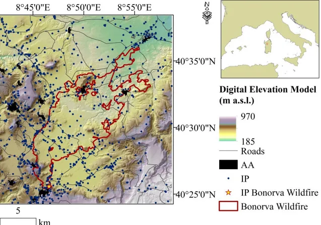
2.2.1 Study area 62
2.2.2 Wildfire data 64
2.2.3 Input data for wildfire modelling 65
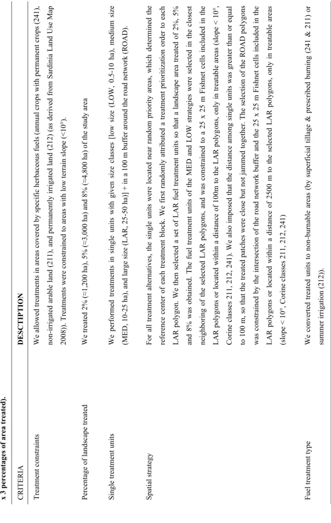
2.2.4 Fuel treatment alternatives 66
2.2.5 Spatial data on selected anthropic values 69
2.2.6 Wildfire simulation modelling 69
2.3 Results 71
2.3.1 Wildfire exposure at the landscape scale 71
2.3.1.1 Burn probability 71
2.3.1.2 Fire size 75
2.3.1.3 Conditional flame length 75
2.3.2 Wildfire exposure to anthropic values 77
2.4 Discussion 81
2.5 Conclusions 89
Acknowledgements 90
Supplementary data 107
Chapter 3: Linking burn probability and erosion models to 109
quantify post-fire erosion risk: a case study from Northern Sardinia, Italy
3.1 Introduction 110
3.2 Material and methods 114
3.2.1 Study area 114
3.2.2 Input data for wildfire modelling 115
3.2.3 Wildfire simulation modelling 117
3.2.4 Input data for erosion modelling 118
3.2.5 Post-fire erosion modelling 121
3.2.6 Modeling fuel reduction effects on post-fire sediment 123 delivery
3.3 Results and Discussion 124
3.3.1 Post fire erosion for actual vegetation conditions 124 3.3.2 Post fire erosion for the different fuel management 133
scenarios and erosion treatments
3.4 Conclusions 138
3.5 References 140
Supplementary data 157
Final conclusions 169
Abstract
Wildfires are a key problem in many terrestrial ecosystems, particularly in the Mediterranean Basin, and climate change will likely cause their increase in future years. Wildfire behavior simulator models are very useful to characterize wildfire risk, identify the valued resources more exposed to wildfires and to plan the best strategies to mitigate risk. In this work, we first carried out a review of wildfire spread and behavior modelling, and then focusing on FLAMMAP model. Then, we evaluated the effects of diverse strategies of fuel treatments on wildfire risk in an agro-pastoral area of the North-central Sardinia (Italy) that has been affected by the largest Sardinian wildfire of recent years (Bonorva wildfire, about 10,500 ha burned, on July 2009). Finally we analyzed the combined effects of fuel treatments and post-fire treatments with the aim to mitigate wildfire and erosion risk, linking the minimum travel time algorithm with the Ermit modeling approach in a study area located in Northern Sardinia (Italy), mostly classified as European Site of Community Importance. Overall, the results obtained showed that wildfire behavior simulator models can support forest fire management and planning and can provide key spatial information and data that can be helpful to policy makers and land managers.
General introduction
Wildfire is a key problem in many terrestrial ecosystem (Pyne et al. 1996; Pausas et al. 2009), particularly in Mediterranean ecosystems. In recent decades, Mediterranean areas suffered an increase in the occurrence of large fires (Moreno et al. 1998; Mouillot e Field 2005; Trigo et al. 2006; Viegas et al. 2006; Riaño et al. 2007; Costa Alcubierre et al., 2011; Alcasena et al., 2015). This intensification is due to various factors, firstly the increased frequency of extreme weather conditions, with hot temperatures, strong winds, low relative humidity and prolonged drought, that can even cause the lengthening of fire seasons (Trigo et al., 2006; Viegas et al., 2009; Koutsias et al., 2012; Pausas and Fernandez-Munoz, 2012; Cardil et al., 2013, 2014; Salis et al., 2014, 2016). Therefore, climate change can influence wildfire occurrence, particularly in conjunction with changes in land uses and consequent land cover variations. Indeed, abandonment of rural areas has promoted a considerable decline in the extent and management of agricultural areas, which have been progressively covered by natural vegetation (e.g. Mediterranean maquis), often highly flammable and capable of causing high intensity fires (Velez 2000; Badia et al. 2002; Pausas 2004; Bonet and Pausas, 2007; Castellnou e Miralles 2009; Ruiz-Mirazo et al., 2012); the increased pressure in coastal and urban areas caused an increase in the risk and in the number of fires in these zones (Pellizzaro et al., 2012; Alcasena et al., 2015; Salis et al., 2016). In addition, a considerable increase in fire suppression costs in the last period caused decreased investments in fuel management and fire prevention activities (Calkin et al., 2005; Stephens and Ruth, 2005; Prestemon et al., 2008; Hand et al., 2014).
An extensive and applied research on wildfire risk management is needed to mitigate the growing incidence of large fires impacting forests, urban interfaces and touristic areas. Simulation models and tools can help researchers to develop risk assessment and mitigation strategies: in particular, wildfire simulation models of the latest generation as FlamMap or Randig allow to work at fine resolutions. Different works based on the Minimum Travel Time (MTT) allowed to simulate thousands of fires (Ager et al. 2007, 2010) employing relatively reduced calculation times. The MTT calculates the fastest fire travel times along straight lines connecting cells in a grid. The MTT can be helpful to study the potential effects of climate change, land use change, vegetation succession and fuel management programs on wildfire behaviour and risk. Furthermore, we can assess other factors as carbon cycling (Ager et al., 2010b) or soil erosion (Robichaud et
al., 2009) using a probabilistic framework able to quantify expected losses. For example, soil erosion models can be coupled with MTT methodologies to evaluate post-fire erosion, which affected several areas of Sardinia (Vacca et al. 2000; Canu et al. 2009).
Some studies have calibrated and validated wildfire simulator models in weather conditions and vegetation that characterize the Mediterranean areas (Arca et al. 2007; Salis et al. 2013, 2016). With the term risk we define the probability that something negative will happen. Wildfire risk can be obtained combining the likelihood that a wildfire occurs at a given intensity and the response in terms of losses which can be caused by that fire intensity. We can mitigate wildfire risk changing the excepted output, by reducing wildfire probability, wildfire intensity or the landscape response or susceptibility (Finney 2005; Ager, 2013; Finney, 2013; Scott et al. 2013). Many studies have examined the potential effect of fuel treatments on fire behaviour and risk by evaluating the potential variation in burn probability or fire intensity. Relevant studies have been implemented successfully in Canada and USA, with a limited application of this methodology in Mediterranean areas (e.g.: Finney, 2001, 2006; Finney et al., 2007; Ager et al., 2007, 2010, 2013; Miller et al., 2008; Moghaddas et al., 2010; Liu et al., 2013; Scott et al., 2013; Salis et al., 2016). The effects of fuel treatments on wildfire growth and behaviour depend both on the characteristics of fuel treatments as for instance: patterns (thickness, spacing and overlap), treatment intensity and size, wind speed and direction, and ignition patterns. Even after fuel treatments, it is basically impossible to eliminate wildfire risk because there are numerous unobstructed straight line wildfire paths, influenced by wind direction and ignition point locations (Finney, .2013? 2007?; Tehrune, 2013), and because fuel treatments typically cover small percentages of a study area.
The aims of the following three chapters are:
1) To review state of the art of wildfire spread and behaviour modelling, focusing on FLAMMAP, describing its principal applications.
2) To present a methodology that can be helpful to design and optimize fuel treatments in order to mitigate wildfire risk in an agro-pastoral area of the North-central Sardinia, Italy.
3) To link fire simulation modeling approach based on the application of the MTT algorithm (Finney 2002) with the Ermit modeling approach (Robichaud 2007) to
characterize post-fire erosion in Northern Sardinia, Italy, and to investigate the combined effects of fuel treatments with aim to reduce the wildfire probability and intensity, and post-fire treatments aimed to mitigate the erosion.
References
Ager, A.A., Finney, M.A., Kerns, B.K., Maffei, H., 2007. Modeling wildfire risk to northern spotted owl (Strix occidentalis caurina) habitat in Central Oregon, USA. Forest Ecology and Management, 246, 45–56.
Ager, A.A., Finney, M.A., McMahan, A., Cathcart, J., 2010. Measuring the effect of fuel treatments on forest carbon using landscape risk analysis. Natural Hazards & Earth System Sciences, 10, 2515-2526.
Ager, A.A., Vaillant, N.M., McMahan, A., 2013. Restoration of fire in managed forests: a model to prioritize landscapes and analyze tradeoffs. Ecosphere, 4 (2), 29. Alcasena, F., Salis, M., Ager, A.A., Arca, B., Molina, D., Spano, D., 2015. Assessing
landscape scale wildfire exposure for highly valued resources in a Mediterranean area. Environmental Management 55, 1200–1216.
Arca, B., Duce, P., Laconi, M., Pellizzaro, G., Salis, M., Spano, D., 2007. Evaluation of FARSITE simulator in Mediterranean maquis. International Journal of Wildland Fire, 16, 563–572.
Badia, A., Saurı́, D., Cerdan, R., Llurdés, J.C., 2002. Causality and management of forest fires in Mediterranean environments: an example from Catalonia. Global Environmental Change Part B: Environmental Hazards 4(1), 23-32.
Bonet, A., Pausas, J.G., 2007. Old field dynamics on the dry side of the Mediterranean Basin: patterns and processes in semiarid SE Spain. In: Cramer, V.A., Hobbs, R.J.(Eds.), Old Fields Dynamics and Restoration of Abandoned Farmland. Island Press, Washington, DC, pp. 247–264.
Calkin, D.E., Gebert, K.M., Jones, J.G., Neilson, R.P., 2005. Forest service large fire area burned and suppression expenditure trends, 1970–2002. Journal of Forestry, 103 (4), 179–183.
Canu, A., Arca, B., Ventura, A., Ghiglieri, G., Pittalis, D., Deroma, M., 2009. Fire effects on soil properties and post-fire recovery in a Mediterranean area. Geophysical Research Abstracts 11, EGU2009-12098.
Cardil, A., Molina, D.M., Ramirez, J., Vega-García, C., 2013. Trends in adverse weather patterns and large wildland fires in Aragón (NE Spain) from 1978 to 2010. Natural Hazards and Earth System Sciences, 13, 1393–1399.
Cardil, A., Salis, M., Spano, D., Delogu, G., Molina, DM., 2014. Large wildland fires and extreme temperatures in Sardinia (Italy). iForest – Biogeosci. Forestry 7, 162–169.
Castellnou, M., Miralles, M., 2009. The great fire changes in the Mediterranean—the example of Catalonia, Spain. Crisis Response 5(4), 56–57.
Costa Alcubierre, P., Castellnou Ribau, M., Larrañaga Otxoa de Egileor, A., Miralles Bover, M., Kraus, P.D., 2011. Prevention of Large Wildfires using the Fire Types Concept. 88p. ISBN: 978-84-694-1457-6.
Finney, M.A., 2001. Design of regular landscape fuel treatment patterns for modifying fire growth and behaviour, Forest Science, 47, 219–228.
Finney, M.A., 2002. Fire growth using minimum travel time methods. Canadian Journal of Forest Research 32(8), 1420–1424.
Finney, M.A., 2005. The challenge of quantitative risk analysis for wildland fire. Forest Ecology and Management 211, 97–108.
Finney, M.A., 2006. An overview of FlamMap fire modeling capabilities. In Andrews PL, Butler BW (Eds), Proceedings of the “Fuels Management-How to Measure Success” pp. 213-220.
Finney, M.A., 2013. Landscape considerations for fire behavior and fuel treatments. Master Piros, University of Sassari, Sassari, 21/22 February 2013
Finney, M.A., Seli, R. C., McHugh, C. W., Ager, A. A., Bahro, B., and Agee, J. K., 2007. Simulation of long-term landscape-level fuel treatment effects on large wildfires, International Journal of Wildland Fire, 16, 712–727.
Hand, M.S., Gebert, K.M., Liang, J., Calkin, D.E., Thompson, M.P., Zhou, M., 2014. Economics of Wildfire Management – The Development and Application of Suppression Expenditure Models. Springer, ISBN: 978-1-4939-0578-2 (online). Koutsias, N., Xanthopoulos, G., Founda, D., Xystrakis, F., Nioti, F., Pleniou, M.,
Mallinis, G., 2012. On the relationships between forest fires and weather conditions in Greece from long-term 20 national observations (1894–2010). International Journal of Wildland Fire 22 (4), 493–507.
Liu, Z., Yang, J., He, H.S., 2013. Studying the effects of fuel treatment based on burn probability on a boreal forest landscape. Journal of Environmental Management, 115, 42–52.
Miller, C., Parisien, M.A., Ager, A.A., Finney, M.A., 2008. Evaluating spatially-explicit burn probabilities for strategic fire management planning. In: De las Heras, J. Brebbia, CA. Viegas, D. Leone, V. (Eds.), Modelling, Monitoring and Management of Forest Fires. WIT Press, Boston, MA, pp. 245–252.
Moghaddas, J.J., Collins, B.M., Menning, K., Moghaddas, E.E.Y., Stephens, S.L., 2010. Fuel treatment effects on modeled landscape-level fire behavior in the northern Sierra Nevada. Canadian Journal of Forest Research, 40, 1751–1765.
Moreno, J.M., Vázquez, A., Vélez, R., 1998. Recent history of forest fires in Spain. Large forest fires, 159-185.
Mouillot, F., Field, C.B., 2005. Fire history and the global carbon budget: A 1× 1 fire history reconstruction for the 20th century. Global Change Biology 11(3), 398-420.
Pausas, J.G., 2004. Changes in fire and climate in the eastern Iberian peninsula (Mediterranean Basin). Climatic change 63(3), 337-350.
Pausas, J.G., Fernandez-Munoz, S., 2012. Fire regime changes in the Western Mediterranean Basin: from fuel-limited to drought-driven fire regime. Climatic Change 110, 215–226.
Pausas, J.G., Keeley, J.E., 2009. A Burning Story: The Role of Fire in the History of Life. BioScience 59(7), 593-601.
Pellizzaro, G., Arca, B., Pintus, G., Ferrara, R., Duce, P., 2012. Wildland urban interface dynamics during the last 50 years in North East Sardinia. Modelling Fire Behavior and Risk; Spano, D., Bacciu, V., Salis, M., Sirca, C., Eds, 249-254.
Prestemon, J.P., Abt, K., Gebert, K., 2008. Suppression cost forecast in advance of wildfire seasons. Forest Science 54 (4), 381–396.
Pyne, S.J., Andrews, P.L., Laven, R.D., 1996. Introduction to wildland fire (No. Ed. 2). 808 pp. John Wiley and Sons. New York.
Riaño, D., Moreno Ruiz, J.A., Isidoro, D., Ustin, S.L., 2007. Global spatial patterns and temporal trends of burned area between 1981 and 2000 using NOAA-NASA Pathfinder. Global Change Biology 13(1), 40-50.
Robichaud, P.R., Elliot, W.J., Pierson, F.B., Hall, D.E., Moffet, C.A., Ashmun, L.E., 2007. Erosion risk management tool (ERMiT) user manual, version 2006.01.18. US Department of Agriculture, Forest Service, Rocky Mountain Research Station, General Technical Report RMRS-GTR-188. (Fort Collins, CO).
Robichaud, P.R., Elliot, W.J., Pierson, F.B., Hall, D.E., Moffet, C.A., 2009. A probabilistic approach to modeling postfire erosion after the 2009 Australian bushfires. In ‘Proceedings of the 18th World IMACS/MODSIM09 Congress. International Congress on Modelling and Simulation’, 13–17 July 2009, Cairns, Qld. (Eds RS Anderssen,RDBraddock, LTH Newham) pp. 1893–1899. (Modelling and Simulation Society of Australia and New Zealand and International Association for Mathematics and Computers in Simulation)
Available at:
http://www.fs.fed.us/rm/pubs_other/rmrs_2009_robichaud_p001.pdf
Ruiz-Mirazo, J., Martinez Fernandez, J., Vega-Garcia, C., 2012. Pastoral wildfires in the Mediterranean: understanding their linkages to land cover patterns in managed landscapes. Journal of environmental management, 98, 43–50.
Salis, M., Ager, A.A., Arca, B., Finney, M.A., Bacciu, V., Duce, P., Spano, D., 2013. Assessing exposure of human and ecological values to wildfire in Sardinia, Italy. International Journal of Wildland Fire 22 (4), 549–565.
Salis, M., Ager, A.A., Finney, M.A., Arca, B., Spano, D., 2014. Analyzing spatiotemporal changes in wildfire regime and exposure across a Mediterranean fire-prone area. Natural Hazards, 71 (3), 1389–1418.
Salis, M., Laconi, M., Ager, A.A., Alcasena, F.J., Arca, B., Lozano, O., Fernandes de Oliveira, A., Spano, D., 2016. Evaluating alternative fuel treatment strategies to reduce wildfire losses in a Mediterranean area. Forest Ecology and Management, 368, 207-221.
Scott, J.H., Thompson, M.P., Calkin, D.E., 2013. A wildfire risk assessment framework for land and resource management. Gen. Tech. Rep. RMRS-GTR-315. U.S. Department of Agriculture, Forest Service, Rocky Mountain Research Station, 83p.
Stephens, S.L., Ruth, L.W., 2005. Federal forest fire policy in the United States. Ecological applications, 15, 532–542.
Tehrune, G., 2006. The False Promise of SPLATs (Strategically Placed Area Treatments). http://snamp.ucanr.edu/documents/30/index.html [Verified 06 January 2019].
Trigo, R.M., Pereira, J.M.C., Pereira, M.G., Mota, B., Calado, M.T., DaCamara, C.C., Santo, F.E., 2006. Atmospheric conditions associated with the exceptional fire season of summer 2003 in Portugal. International Journal of Climatology 26(13), 1741-1757.
Vacca, A., Loddo, S., Ollesch, G., Puddu, R., Serra, G., Tomasi, D., Aru, A., 2000. Measurement of runoff and soil erosion in three areas under different land use in Sardinia (Italy). Catena 40, 69–92.
Velez, R., 2000. La defensa contra incendios forestales: fundamentos y experiencias. McGraw-Hill, Madrid.
Viegas, D.X., Abrantes, T., Palheiro, P., Santo, F.E., Viegas, M.T., Silva, J., Pessanha, L., 2006. Fire weather during the 2003, 2004 and 2005 fire seasons in Portugal. Forest Ecology and Management, 234, S60.
Viegas, D.X., Simeoni, A., Xanthopoulos, G., Rossa, C., Ribeiro, L.M., Pita, L.P., Stipanicev, D., Zinoviev, A., Weber, R., Dold, J., Caballero, D., San-Miguel-Ayanz, J., 2009. Recent Forest Fire Related Accidents in Europe. European Commission Joint Research Centre Institute for Environment and Sustainability, Luxembourg.
Chapter 1: Introduction to wildfire behavior
modeling and potential of the Minimum Travel
Time (MTT) fire spread algorithm
1.1 Introduction
In the last years several works attempted to model the behavior of wildland fires and to simulate their spread across the landscape (Sullivan, 2009a; 2009b; 2009c). Wildfire behavior simulator models are very useful to help manager in environmental policy, to identify the risk factors in the landscape and to identify the valued resources and assets more exposed to fire. Furthermore, they are helpful to plan fuel treatments to mitigate fire risk (Scott et al., 2013; Calkin et al., 2011) and to support forest fire fighting and fire management (Guariso and Baracani, 2002)
There are different typologies of fire models, and several authors provided different classifications of them: for instance Sullivan (2009) suggested a classification based on the heat transfer and distinguished four main types of fire behavior models: physical, quasi-physical, quasi-empirical and empirical. Physical models are based on physical and chemical low (Albini, 1986; Balbi et al., 2007, 2010), empirical models don’t consider physical and chemical theories but are based on observed data or experiments (McArthur, 1966), quasi-empirical models are based on physical and empirical models, and quasi-physical models only consider physical laws.
Overall, the fire behavior simulator models are characterized by a fire simulation technique, that describes the spreading of fire through the landscape. The difference
between each fire simulation technique is the way in which the landscape and the spreading process are represented (Albright and Meisner, 1999). Among these techniques, we can mention the cellular technique, the elliptical wave propagation, the minimum travel time (MTT) (Finney, 2002), and the level set method (Rehm and McDermott, 2009).
A group of wildfire behavior simulator models, as for example FlamMap or Randig, can simulate thousands of fires in relatively limited calculation times, using the minimum travel time approach (Ager et al. 2007, 2010). The MTT calculates the fastest fire travel times along straight lines connecting cells in a landscape grid that represent the area under study. The MTT is able to predict fire behavior and can take into account different weather conditions and wind directions for the set of simulations defined in a given study area.
The aim of this work is to provide a brief review of fire behavior simulator models and to describe the principal applications of FlamMap MTT.
1.2 Fire behavior simulator models: classifications
1.2.1 Classification based on the heat transfer modeling
Wildfires are the result of combination of heat transfer across fuel due to combustion process and the related chemical reactions (Sullivan, 2009a). In the last years, several authors developed models with the aim to simulate wildfire behavior and spread.
Fig. 1. Classical description on flame spread mechanism. Picture from: Dupuy et al., 1999.
These models consider the space in which there is the fire into heat source, that includes combustion zone, flame and ignition interface, and heat transfer, that comprises heat sink (unburned fuel) (Fig. 1) (Dupuy et al., 1999). The models can be classified into typologies that are different in complexity because there are physical models, that use physical and chemical theories involved in fire combustion to simulate fire behavior (Albini, 1986; Balbi et al., 2007, 2010), empirical models that don’t consider physic and chemical theoretical laws and are based on observed data or experiments (McArthur, 1966), quasi-empirical models that are based on physical and empirical models, and finally quasi-physical models that only use physical laws. Several authors proposed diverse classifications of the fire behavior simulator models, among which Perry (1998), Pastor et al. (2003) and Sullivan (2009a, 2009b, 2009c), are the most complete.
1.2.1.1 Physical models
Physical models replicate a complex mix of chemical and physical laws generated by wildfire, in particular combustion process and transfer of energy to generate new ignition and heat transfer, without modeling of wildfire-atmosphere interaction (Arca et al., 2015; Salis, 2008; Mazzoleni and Giannino, 2014; Perry, 1998; Albright and
Meisner 1999; Pastor et al., 2003; Johnston et al., 2005) and it is fundamental to have details of heat sources in addition to spread factors (Dupuy et al., 1999). These models are based on known physical and chemical laws, so comparing different cases is very simple (Chandler et al., 1983; Salis, 2008) and this property facilitates their scaling (Arca et al., 2015).
The development of a physical model to model wildfire fire behaviour can be split into five steps, according to Grishin (1997): (1) To understand the physical phenomenon of wildland fire spread, particularly the transfer of energy from burned to unburned area. (2) Determination of coefficients and structural parameters, and identification of the most appropriate equations. (3) Choice of numerical solutions of the problem. (4) Checking of the model (numerical solution and system of equations). (5) Testing of model with the reality (Sullivan, 2009a).
These models do not consider the interactions between wildfire and atmosphere and use packing ratio, moisture content and the surface area to volume ratio as fuel characteristics. This can be interesting to study wildfire guided by heat transfer because heat flux and flame properties are considered fix (Weber, 1991).
Other physical models consider non-steady propagation (Weber, 1989), convection heat term (Albini, 1986) and temperature gradient inside the particles (Thomas, 1967). In recent works, physical models include the degradation of the vegetation or the turbulent/reactive flow resulting from the mixing between the ambient gas and the pyrolizate using the computational fluid methods (Morvan and Dupuy, 2001, 2004). 1.2.1.2 Quasi-physical models
Quasi-physical models are based on physical laws such conservation of energy (heat), like physical models, but in this case the heat transfer is not quantified by chemistry, such as physical models, but often it is determinate using an empirical approach. This model needs to data of the flame geometry to close the system of equations. Another characteristic is that it may not be internally self-consistent (Sullivan, 2009a).
1.2.1.3 Quasi-empirical models
These models combine physical and empirical models (Burrows, 1999a, 1999b; Catchpole and de Mestre, 1986; Marsden-Smedley and Catchpole 1995a, 1995b; Simeoni et al., 2001, 2003). In order to model fire behavior, physical theories about
combustion and heat transfer are combined to models with statistical correlations obtained in laboratory from fire experiments (Albright and Meisner, 1999; Pastor et al., 2003; Salis 2008). Validation of these models is simpler than the physical ones and can be applied in situations different from laboratory (Pastor et al., 2003; Johnston et al., 2005).
The most used quasi-empirical model in Mediterranean area is the one proposed by Rothermel in 1972 (Pastor et al., 2003; Sullivan, 2009b) and was the basis of the National Fire Danger Rating System (Deeming et al. 1977; Burgan 1988) and the fire behaviour BEHAVE (Andrews 1986). This model is based on the physical model of Frandsen (1971) and on experimental data obtained by Rothermel and Anderson in 1966 using wind tunnel experiments in artificial fuel beds of varying characteristics and by McArthur in 1966 in Australia, with input variables and a range of wind speed conditions. After a preliminary calibration, this model is applicable to various contexts. In Canada the most used quasi-empirical model is the Fire Behavior Prediction (FBP) System (Forestry Canada Fire Danger Group 1992), which is included in the Canadian Forest Fire Danger Rating System (CFFDRS) (VanWagner 1998; Taylor and Alexander 2006). The model was the result of a long research and many experiments and it is applicable in several countries such as Asia, Mexico and New Zealand. Almost 500 fires were used in the construction of the FBP system; 400 were field experiments, the remainder well-documented observations of prescribed and wildfires. The CFFDRS has been introduced and implemented in several countries, including New Zealand, Mexico and several countries of south-east Asia.
1.2.1.4 Empirical models
Statistical correlations can be extracted from experimental fires reproduced in laboratory or in the field, with the aim of determinate the characteristics of fire behavior (rate of spread, head fire, perimeter, etc.) and the characteristics of flames (Noble et al., 1980; Cheney and Gould, 1995, 1997; Cheney et al., 1998, Mc Arthur, 1966; Sullivan, 2009b). These characteristics can be obtained also observing fire with aim of hazard reduction or prescribed fires (Sullivan, 2009b). Empirical models describe wildfire features without considering the physical mechanisms which drive the fire process (Perry, 1998). These models are linked to experimental conditions, so it is difficult to apply them to other situations (Marsden-Smedley, 1993).
The development of a empirical model to model wildfire fire behaviour can distinguish into four steps (Sullivan, 2009b): (1) determination of physical and quantitative characteristics of the fuel and description of terrain data (slope, aspect, etc); (2) characterization of the atmospheric environment (wind, temperature, moisture, etc); (3) observation of fire and measurement of its variables (spread, flame, smoke, etc.); (4) finally statistical correlation between the variables.
The first empirical model was very simple and had the aim of evaluate wildfire spread linked to wind and slope, and so aid to plan suppression actions (Chandler et al. 1983). Given their simplicity the empirical models were one-dimensional and were accepted by wildland fire authorities because of own immediate use (Sullivan, 2009b).
In Australia the most used empirical model to predict fire spread were the McArthur Grassland (McArthur1965, 1966) and Forest (McArthur 1967) Fire Danger Rating Systems (FDRS), and the Forest Fire Behaviour Tables for Western Australia (Red Book) (Sneeuwjagt and Peet 1985. In recent years McArthur Grassland FDRS was replaced by CSIRO Grassland Fire Spread Meter (GSFM) (Cheney and Sullivan1997), which is based on empirical model of Cheney (1998) (Sullivan, 2009b) and was the first model which used experimental plots greater than or equal to 1 ha.
1.2.2 Other classification based on the modelled physical system
There are other classifications of fire models, based on the physical system studied in the simulations (Albright and Meisner, 1999; Pastor et al., 2003; Johnston et al., 2005). We can classify them into surface fire models, crown fire models, spotting models, and ground fire models.
1.2.2.1 Surface fire models
To simulate fire spreading through fuels contiguous to the ground, we can use these models. Surface fuels refer to fuels lower than 2 m in height, i.e. grass, shrubs, small trees. The final aim is to determine surface fire rate of spread, fire line intensity, flame height and fire length-to-width ratio, that are the most important fire characteristics. The Rothermel’s model is the most used to evaluate surface fire behavior (Rothermel, 1972). Rothermel’s model is based on law of the conservation of energy linked to radiative heat transfer and simulate rate of spread using environmental data of fuel, weather and topography.
1.2.2.2 Crown fire models
These models simulate fires that burn canopies. We can divide the crown fire predictive models into two groups: crown fire initiation models and crown fire spread models (Pastor et al., 2003). The first provides an analysis of surface to crown fire transition, the second characterizes crown fire behavior.
There are several studies that predict fire line and rate of spread conditions for passive, active and independent crown fire transition, for instance Van Wagner (1993), Rothermel (1991) and Dickinson et al. (2007). These models are largely used in spite of their empirical nature.
1.2.2.3 Spotting models
Spot fires originated from fire front can cause an independent new fire that needs a different modelling. These models are largely integrated into the Forest Service calculation system (Rothermel, 1983; Alexander et al., 2004). Overall, spot fires are modelled by few authors, including Albini (1979, 1981, 1983).
1.2.2.4 Ground fire models
Ground fires can cause many human and assets losses, they burn without flames and at very slow spread rates, but damage organic layer of the soil and heat the inorganic layer (Pastor et al., 2003). Probability of ground fire ignition was studied by Frandsen (1987) and Hartford (1989) with a series of experiments. Schneller and Frandsen (1998) and Frandsen (1998) carried out a study on heat flux in a ground fire.
1.3 Fire simulation techniques
Fire simulation techniques characterize each fire model simulator and describe the spreading of fire through the landscape. Each fire simulation technique is characterized
by the way in which represent the landscape and the spreading process (Albright and Meisner, 1999). Four principal fire simulation techniques to simulate the spread of fire through the landscape can be distinguished: cellular technique, elliptical wave propagation technique, minimum travel time and level set method.
1.3.1 Cellular technique: cellular automata models
Cellular automata is a discrete model studied in various sectors, like mathematics, physics and biology and it is very used in the complex systems science (Karafyllidis and Thanailakis, 1997; Ohgai et al., 2007; Gao et al., 2008). The cellular automata model is a regular grid of cells, each with a set of possible values, such as fuel type, elevation, slope, etc., and an initial state before ignition (Albright and Meisner, 1999). This technique is very used because of its inherent parallelism, regularity and modularity (Cohen et al., 2002; Zeigler, 1987). How does the cellular automata models about fire work? There is a spread mechanism from a cell to his neighbors that is guided by group of cells with similar state, either active or inactive. This technique allows to perform a huge number of simulations, but we need to use techniques for high performance computing (Innocenti et al., 2009).
Fig. 2. Example of fire behavior simulation using cellular automata. Picture from: Clarke et al., 1994.
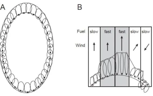
1.3.2 Elliptical wave propagation technique
The elliptical wave propagation technique is based on the Huygens’ wavelet principle, that was originally proposed for the propagation of light waves and that can be applied to fire spread simulation (Sullivan, 2009c). The Huygens’ wavelet principle states that
each point on a fire perimeter is a theoretical source of a new fire. This new fire is characterized by the given fire spread model and the conditions of the location of the origin of the new fire. It is assumed that the new fires around the perimeter ignite simultaneously, and each new fire attains a certain size and shape. The outer surfaces of all the individual fires become the new fire perimeter for that time (Anderson et al., 1982; Sullivan 2009c; Arca et al., 2015). With this technique, we can simulate correctly wildfire with not heterogeneous environmental conditions (French, 1992). The model fire shape under uniform condition is the simple ellipse (Van Wagner, 1969) and other alternative and more complex ellipse shapes have been proposed by Dorrer (1993) and Wallace (1993). Several studies demonstrated the applications of the use of Huygen‘s principle to modelling surface fire growth, for instance Coleman and Sullivan (1996), and Richard and Brice (1995).
Fig. 3. Illustration of Huygens’ principle using elliptical wavelets. (A) Uniform conditions use wavelets of constant shape and size to maintain the elliptical fire shape over time. (B) Nonuniform conditions showing the dependency of wavelet size on the local. Picture from: Finney, 1998
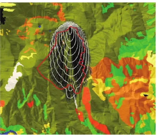
1.3.3 Minimum travel time
The minimum travel time algorithm was developed by Finney (2002). This technique calculates the fastest fire travel time along straight-line transects connecting nodes (cell corners) of the grid (Finney 2002, 2006). Fire-behavior values in the underlying cells of the grid are used to evaluate fire behavior and travel times along the line segments.
Fire behavior characteristics depend on different spatial data themes as major fire-spread direction, maximum fire-spread rates and intensities, and the elliptical fire shape dimensions. The fire shape defines the Cartesian expansion rates of an elliptical fire along the ground surface (Anderson et al. 1982; Finney, 2002). The MTT considers all environmental conditions constant in time to calculate fire growth (Finney, 2006).
Fig. 4. Example of wildfire simulation using the MTT. Picture from: Opperman et al., 2006 1.3.4 Level set method
The level-set method is an efficient and versatile method used in recent years to describe wildfire propagation. The method describes the fire front as a discretized set of cells that expand at a given rate of spread and it does not require information on the shape of the fire front. This method calculates the fire spread using information of the fuel properties and environmental condition typical of landscape. This information is attributed to each cell of grid and determines the state of the cell (Chen et al., 2018). The level-set method can calculate the normal vector to the fire front, models wind- aided fire spreads, and can merge separate fire fronts automatically and the ignition points naturally evolved into an elliptical form, according to the test conducted by Rehm and McDermott (Rehm and McDermott, 2009). The level-set method is very useful to be implemented and coupled with physical based models, considering that the
same grid can be used by both models (Chen et al., 2018). The level-set method has been incorporated by many fire models such SWWS (Ghisu et al., 2014).
1.4 Main wildfire simulators
Wildfire simulators are built to be practical, easy to implement and to provide timely information on the progress of fire spread for wildland fire authorities (Sullivan, 2009c). There are several wildfire simulators: in this work we will only describe some of them. In 1990, Green et al. developed IGNITE, a raster-based fire spread model that simulates fires in landscape with heterogeneous fuels. It utilizes fire spread models of McArthur (1966, 1967) as primary spread model and the propagation model of Green et al. (1983). The model is provided with a geographic information system that permits of importing and editing maps (Green at al., 1990).
Another program is FIREMAP, developed by Vasconcelos and Guertin in 1992 that permits to estimate wildfire behavior in discrete time steps and in spatially non-uniform environments. This simulation system uses Rothermel's behavior prediction model (Rothermel, 1972) as primary spread model and permits to show the outputs as digital maps (Vasconcelos and Guertin, 1992). It can simulate the fire suppression actions (Papadopoulos and Pavlidou, 2011)
FARSITE was developed by Finney in 90’s (Finney, 1994) and is a two-dimensional fire spread simulation model. The base of FARSITE is the semi-empirical model of Rothermel (1972), and the spread of fire through the landscape technique is based on the Huygens’ principle (Richards, 1990; Finney, 1998). The model requires 5 mandatory input layers such elevation, slope, aspect, fuel models, canopy cover, in the form of ASCII files. 3 other layers (crown base height, stand height, and crown bulk density) can be also included in the so-called Landscape file. Furthermore, the model needs the fuel bed characteristics and the fuel moisture. Fuel bed characteristics can be summarized using fuel models; the fuel models can be standardized (Anderson, 1982; Cruz, 2005; Scott and Burgan, 2005) or customized for some distinguishing vegetation type. FARSITE also requires weather and wind data.
In 1994 Coleman and Sullivan proposed a model called SiroFire. This program is a DOS protected mode application and could be applied to the grass and forest in Australia. It uses GIS-derived geographic maps and digital elevation models to simulate the fire behavior and provides graphical outputs. This model uses fire spread model of McArthur (1966, 1967) and of Cheney et al. (1998) as primary spread model and as propagation method Knight and Coleman (1993) (Coleman and Sullivan, 1996).
Karafyllidis and Thanailakis in 1997 model presented the Thrace model, that can simulate fire in homogeneous and inhomogeneous forests and incorporates weather conditions and land topography. The simulator was based on the Rothermel (1972) spread model (Karafyllidis and Thanailakis, 1997).
Pyrocart is a model implemented by Perry et al. in 1999 that simulates fire behavior. The Rothermel spread model was integrated with geographic information system (GIS) by PYROCART. It uses the propagation method of Green at al. (1983). This model was validated in a work of Perry at al. (1999) and the predictive accuracy of the model was estimated to be 80%. The model was dominated by slope and fuel (Perry et al., 1999). FlamMap is a fire behavior model implemented by Finney in 2002. FlamMap uses the minimum travel time to simulate potential fire behavior characteristics, fire perimeters, and burn probabilities. We will examine in depth FlamMap in the 6th chapter.
Guariso e Baracani in 2002 presented a software system to simulate fires in Mediterranean area at small-scale called PdM. This model uses Valette’s classes of flammability. The fuel is composed of two-layer cellular automata, one for the crowns of the trees and one for the surface coverage. In the model they introduce slope, air temperature and moisture data as coefficients following Rothermel’s model and consider wind as Alexander’s ellipse theory. The software can be a support for fire-operators with real-time data. Indeed, the simulator automatically retrieves GIS coverage and digital terrain model data, shows on the screen all the active operators by GPS positioning, saves and re-runs any step of the simulation to test different fire management actions (Guariso and Baracani, 2002).
Lopes et al. (2002) presented the software FireStation. This is a semi-empirical model that simulates fire in landscape with complex topography and provides as outputs fire rate of spread. The model requires topographic inputs, fuel characteristics and wind data. The primary spread model is Rothermel (1972). Fire shape is developed following an ellipse-type model. Wind field was simulated by two models that are based on local observations. The model has a graphical interface that help the user to use it (Lopes et al., 2002).
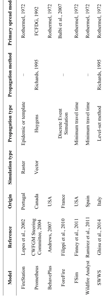
Ta ble 1. Su mm ary o f s imu la tio n mo dels pu bl ishe d in t he lite ra ture 19 90 –2 00 M odified by Su lliv an, 20 09 c Pri m ary spre ad m od el Mc A rthur , 1967 Rot her m el , 1 972 Rot her m el , 1 972 Mc A rthur , 1967 ; C hen ey et a l., 199 8 Rot her m el , 1 972 Rot her m el , 1 972 Rot her m el , 1 972 Rot her m el , 1 972 Rot her m el , 1 972 Propagat ion m et hod G ree n e t a l., 19 83 – Ri cha rds, 1 995 K ni ght and Co le m an, 1993 – G ree n et a l., 19 83 – Ri cha rds, 1 995 – Propagat ion type Epide m ic or te m pl at e Mi ni m um tr ave l t im e H uygens H uygens Mi ni m um tr ave l t im e Epide m ic or te m pl at e Mi ni m um tr ave l t im e Level -se t m et hod Mi ni m um tr ave l t im e Sim ul at ion type Ras te r Ras te r V ec to r V ec to r Ras te r Ras te r Ras te r Ras te r O ri gi n A ust ral ia Port ugal U SA A ust ral ia G ree ce N ew Zeal and U SA Italy Italy R ef er ence G ree n e t a l., 19 90 V as conc el os a nd G uer tin, 19 92 Finne y, 1994 Col em an a nd Sull ivan, 1996 K ar af yl lid is and Thanai lak is, 1997 Per ry et al . 1999 Finne y, 2002 G hi su e t a l., 20 14 G uar iso a nd B ar ac an i, 2002 Model IGN ITE FIRE MAP FA RSITE Sir oF ire Thr ac e PY RO CA RT Fl am Ma p SWWS PdM
Ta ble 1. Co nt. Pri m ary spre ad m od el Rot her m el , 1 972 FC FD G , 1992 Rot her m el , 1 972 Bal bi et al ., 2007 Rot her m el , 1 972 Rot her m el , 1 972 Rot her m el , 1 972 Propagat ion m et hod – Ri cha rds, 1 995 – – Ri cha rds, 1 995 Propagat ion type Epide m ic or te m pl at e H uygens D isc ret e Even t Sim ul at io n Mi ni m um tr ave l t im e Mi ni m um tr ave l t im e Level -se t m et hod Sim ul at ion type Ras te r V ec to r O ri gi n Port ugal Cana da U SA Fra nc e U SA Spai n Ita ly R ef er ence Lopes e t a l., 20 02 CWFG M St ee ring Com m itt ee, 2004 A ndr ews, 2 007 Fil ippi et al ., 2010 Finne y et al ., 2011 Ram irez et al ., 2011 G hi su e t a l., 20 14 Model Fir eS ta tio n Pr om et heus Beha veP lus For eF ire FS im Wi ldf ire A nal yst SWWS
The Canadian Wildland Fire Growth Model Project Team (2004) developed Prometheus (Forestry Canada Fire Danger Group 1992), that is a deterministic wildland fire growth simulation model based on the Fire Weather Index (FWI) and Fire Behavior Prediction (FBP) sub-systems of the Canadian Forest Fire Danger Rating System (CFFDRS). Prometheus uses primary spread model of FCFDG and Richards (1995) as propagation method. The model simulates fire behavior and spread considering heterogeneous fuel, topography and weather conditions. It produces GIS compatible outputs.
The first version of BehavePlus was released in 2002 (Andrews, 2007). This program can be used for any fire management application and to calculate fire behavior. Its primary spread model is Rothermel (1972). It produces outputs such surface and crown fire rate of fire spread and intensity, probability of ignition, fire size, spotting distance, and tree mortality. The program needs type and moisture fuel data to simulate wildfire (Andrews, 2007).
ForeFire was developed by Filippi et al. (2010) to estimate fire spread and was based on the physical model of Balbi et al. (2007). A set of custom fuel models was also developed to calibrate the model. ForeFire is based on the Discrete Event Simulation method (DEVS) (Ziegler, 1987).
FSim is a fire simulation model that focuses on the simulation of large-fire, and was developed by Finney et al. in 2011. The model can simulate spatial and temporal variation in weather and fuel moisture with run of thousands years in order to capture rare fire events. It is composed of different modules, each one devoted to a component of wildfires: weather data, fire ignition, fire suppression and fire growth. The weather generation module simulates wind speed, wind direction, and fuel moistures by percentage of dry weight for six fuel categories, and generates a fire danger rating index called Energy Release Component (ERC). Large fire ignitions are evaluated by analyzing the relationship of historic large fire ignitions with ERC and are calculated by logistic regression. Fire suppression is estimated using statistical model of containment based on large fire records. Fire growth and behavior are calculated using Rothermel (1972) to evaluate the spread and intensity of surface fire and Rothermel (1991) and Van Wagner (1977) to calculate crown fire. The propagation is based on the MTT (Finney, 2002). FSim includes spotting modeling from torching trees (Albini 1979).
Wildfire Analyst (WFA) is a desktop software application developed by Ramirez and Monedero (2011). This model can provide real time analysis of wildfire progression, fire behavior, suppression capabilities and impact analysis during a wildfire. The primary spread model in the WFA tool is the Rothermel (1972) model and the modifications proposed by Albini (1976). The propagation technique is the MTT (Finney, 2002). WFA can simulate, among other things, the evacuation time mode, that is the minimum time required for a fire to reach the defined evacuation points (Ramirez and Monedero, 2011).
The Sardinian web-based wildfire simulator (SWWS) is a software application developed by National Research Council of Italy, Institute of Biometeorology. This model uses the level-set method to simulate the wildfire propagation. The fire-spread model is based on Rothermel’s surface fire spread model (Rothermel, 1972; Ghisu et al., 2014; Arca et al., 2018).
1.5 Main Assumptions and Limitations of Fire Spread and behavior Models “All models are wrong, but some are useful” (George Box, 1979). This sentence summarizes the uncertainty and the nature of models. Models are simplification of reality, that reduce complex phenomena, as wildfires, in mathematical equations. Considering that there are several factors involved in fire spread and behavior, as topography, vegetation and meteorology, and that their interrelations are very complex, it is impossible to perform a simulation without uncertainty (Viegas, 2002).
Riley and Thompson (2017) analyzed the uncertainty of wildfire modeling and highlight three important dimension of uncertainty: nature, locations and levels. Nature can be linked to knowledge or to variability; the first case is reducible because the limitation is referred to understanding, the second is irreducible because is pertained to natural and anthropic systems. Uncertainty can have different locations, that are context (basic assumptions of model), inputs of model, model structure, model technics and parameters. Finally, levels of uncertainty pass from total determinism to total ignorance and between these endpoints there are 1) statistical level, that can be mitigate probabilistically or quantitatively, 2) scenarios, for which we know results but not their likelihood, and 3) recognized ignorance, in which we know the source of uncertainty but not the different possibilities or their likelihoods.
Fig. 6. Representation of the three dimensions of uncertainty (nature, location, level). Picture from: Riley and Thompson, 2017.
One of the principal simplifications used by several fire model is to consider continuous and homogeneous fuels. This problem is very important because real vegetation is different: this influences the goodness of prediction, especially for the works at high resolution (Parsons et al. 2011). This simplification interests both moistures as well the physical characteristics of fuels (Cheney 1981). Several authors tried to solve this question, for example Rothermel in 1983, which introduced two-fuel model concepts and the use of GIS based fire growth models such as FARSITE (Finney, 1994). However, future research still should focus on this topic (Parson et al., 2011).
Several models consider fuel bed like a single layer and continuous to the ground. In the last years, some authors improved the studies on this topic using both physical models, for example Linn and Cunningham. (2005), as well empirical models, as Van Wagner (1977), Cruz and Alexander (2013), and Cheney et al. (2012) (Alexander and Cruz, 2013).
Wildfire is influenced by wind, slope and fuels. Some models consider these factors separately to ease simulations, but this is a simplification (Viegas, 2004). Several authors tried to combine the effects of diverse factors: for instance, Rothermel in 1972 introduced factors of wind and slope with the same directions and gradients in his fire model, and in 1983 he modified the interactions of wind and slope considering a not parallel effect. This model is the more used by most fire behavior prediction systems (Viegas, 2006).
As already mentioned, wildfires spread from burned to unburned fuels by heat transfer (Drysdal, 1998). However, various works do not reach the general conclusion on the ignition and spread of wildfires (Finney et al., 2013). This fact causes an uncertainty in the simulations, because the limited knowledge in fundamental principles of fire propagation (Finney et al. 2015). For instance, many models are based on the theory that radiation produced by the combustion process is the main heat source responsible for fuel particle ignitions and first phases of spread of wildland fire, but recent works revealed that only radiation is insufficient alone to support fire spread (Finney et al., 2015). Finney et al. (2015) also state that beyond radiation also convection has a key role in fire spread and ignitions, and this topic needs to be further investigated.
Fig. 7. Compounding uncertainty across planning levels. As modeling frameworks move from shorter to longer‐term planning contexts, additional sources of uncertainty come into play, and existing sources of uncertainty grow in magnitude. Picture from: Riley et al., 2017.
The time frame used in wildfire simulations is very important, because the planning horizon is directly proportional to uncertainty. If we consider a time frame of 10 years we do not have certainty of ignitions, weather, landscape, and management data for all years. It is better to consider a brief time range to have better and more certain simulations (Fig. 6) (Riley and Thompson, 2017).
Finally, we have to know which variability is involved and the context to mitigate the uncertainty.
1.6 FlamMap: potential and main applications
FlamMap is a software, free to download, that analyzes and maps fire behavior, calculating potential fire behavior characteristics like spread rate, flame length and fireline intensity using the Minimum Travel Time (MTT) algorithm (Finney 2002). FlamMap considers constant weather and fuel moisture conditions in the single temporal propagation unit and does not simulate their temporal variations in fire behavior (Papadopoulos, 2011).
Improved versions of FlamMap is the so-called MTT version, as well as Randig, a command line version of MTT. These models can simulate thousands of fire events using multiple weather scenarios selecting a random sequence among the scenarios defined in a specific input file according to their relative probability (Kalabokidis et al., 2014).
Fig. 8. Main menu of FlamMap
Using the MTT it is possible measure the areas where there are overlapping fires, and so it is possible crate burn probability maps. The maps of outputs produced by FlamMap are helpful to identify particular combinations of fuels, topography and wheatear that can cause a greater fire risk, so we can focus on these areas the prevention and suppression actions (Stratton, 2004)
There are various applications of FlamMap in several papers. We will analyze some of these, in particular the evaluation of wildfire exposure, the effects of fuel treatments, the effects on soil losses and the risk transmission. Often these applications can be
combined in several works. In the Mediterranean area there are lots of works on wildfire exposure that used FlamMap MTT or Randig.
1.6.1 Evaluation of wildfire exposure
Arca et al. analyzed differences in term of burn probability and fire severity variations among different weather scenarios in Sardinia (24,000 km2). These scenarios derived from the Regional Climate Model (RCM) EBU-POM, implemented by the Belgrade University and the Euro-Mediterranean Center for Climate Change (CMCC). In this study Arca et al. considered as baseline climate scenario the current Mediterranean climate (1961-1990) and the future period 2071-2100. They used Randig (Finney, 2006) and simulated 100,000 random fires using ignition points obtained by historical ignition points (Arca et al., 2012).
Ager et al. (2012) evaluated wildfire exposure in the Deschutes National Forest near Bend, Oregon (6530 km2). They used Randig (Finney et al., 2006) to simulate wildfire
and generated maps of burn probability, conditional flame length and fire size. They also evaluated wildfire risk transmission and calculated the source-sink ratio (SSR) of wildfire calculated as the ratio of fire size generated by an ignition to burn probability. 50,000 wildfires were simulated at a 90 m spatial resolution (Ager et al., 2012).
Salis et al. (2013) applied a burn probability modelling approach in Sardinia (24,000 km2), to evaluate wildfire exposure from large fire events of social, economic and ecological resources. They simulated 100,000 wildfires at 250 m resolution. Similar approaches, working at resolution of 200 m and 150 m, were used to evaluate spatiotemporal variations in wildfire intensity and size, and burn probability in Sardinia (Salis et al. 2014, 2015).
Kalabokidis et al. (2014) used Randig to evaluate fire exposure of two areas in Greece, i.e. Lesvos Island (in North Aegean Sea, 1,650 km2) and Messenia (in Southwestern Peloponnesus, 3,000 km2). They calculated burn probabilities, fire size and flame length
probability and furthermore they evaluated fire hazard and vulnerability taking into consideration values-at-risk. They simulated 100,000 fire events for the two study areas (Kalabokidis et al. 2014)
In 2015 in another work Kalabokidis et al. carried out a work on fire regime in Messinia, (in Southwestern Peloponnesus, 3,000 km2), for the present (1961–1990) and
the future (2071–2100) climate projections. These projections derived from simulations of the KNMI regional climate model RACMO2, under the SRES A1B emission
scenario. To achieve this goal, they divided the whole study area in three landscapes and simulated using Randig 100,000 fires for 300 min of wildfire duration for each landscape at 60 m resolution. They obtained burn probability, potential fire spread and intensity values (Kalabokidis et al. 2015).
Mitsopolous et al. (2015) evaluated the effects of three different burning condition scenarios on the wildland urban interface in Greece, Mt. Penteli (160 km2) and
calculated wildfire risk components as burn probability, conditional flame length, fire size, and source–sink ratio using FlamMap. They created custom fuel models specific of the study area using the field fuel parameters and they localized the different fuel types and residential structures in the study area using photointerpretation procedures of large scale natural color orthophotographs. They simulated 10,000 fires at 30 m resolution (Mitsopoulos et al. 2015).
In a work of 2016, Mitsopoulos et al. used FlamMap to evaluate fire behavior in Greece (Mt. Penteli, 160 km2). They considered four summer periods, one referring to present,
2000, and three to future, 2050, 2070 and 2100, under the A1B emissions scenario. They used as ignition point for all simulations the starting spot of a large fire in 2009 that burnt 14,000 ha in the study area. The duration of fire was 480 min at 30 m resolution. They obtained outputs useful for fire management planning across the landscape and being related to climate change they are valuable components of long terms fire prevention and management (Mitsopoulos et al. 2016).
Alcasena et al. (2015) used FlamMap 5 (Finney, 2006) to simulate wildfires and evaluate the burn probability and intensities at landscape scale. They analyzed and mapped wildfire exposure for the different Highly Valued Resources (HVR) structures in province of Nuoro, Sardinia (680 km2). They simulated 90,000 fires at 40 m
resolution considering extreme moisture conditions and wind by historical data and historical fire ignitions (Alcasena et al., 2015).
Fréjaville et al. (2015) carried out a study in two areas of Provence (south-eastern France) affected by wildfires. These areas were similar in terms of climate, but had different fuel types and landscape characteristics. They simulated with FlamMap 125,000 fires per weather scenario, obtaining the burn probability and fire behavior metrics. They combined these indicators and calculated the fire severity index (FSI) that linked the probability of burning of an area with the intensity and residence time of occurring fires (Fréjaville et al., 2015).
In another work of 2016, Alcasena quantified wildfire exposure of Highly Valued Resources and Assets (HVRAs) in an area of 280 km2 in Central Navarra (Spain) using
MTT algorithm in FlamMap 5 (Finney, 2006). They used Lidar data to characterize canopy fuel, and using recent fire weather and moisture conditions data and historical ignition patterns. They simulated 30,000 fires at 20 m resolution and they evaluated burn probability, conditional flame length, fire size, and source–sink ratio (Alcasena et al., 2016).
Fréjaville et al. (2016) used FlamMap to simulate wildfire in an area of Western-Alps (31,710 km2) with the aim of evaluating fire spread and intensity and the effects of climate, vegetation composition and fuel moisture on fire behavior. They performed various simulations for different scenarios of wind speed and fuel moisture, with fixed wind direction. In this study they linked wildfire simulations with multivariate analysis (Fréjaville et al., 2016).
Mallinis et al. (2016) carried out a work with the objective to analyze the spatial variation of wildfire regime in Holy Mount Athos in Greece (330 km2) that includes 20
monasteries and other structures frequently interested by wildfires. They used FlamMap to simulate 30,000 fire for 480 min of duration at high resolution and they calculated evaluate burn probability (BP), conditional flame length (CFL), fire size (FS), and source-sink ratio (SSR). They created custom fuel models determined by fuel sampling and high-resolution images (Mallinis et al., 2016).
Thompson et al. (2016) proposed a new risk assessment approach that integrates complementary pixel-based outputs of fire behavior and polygon based outputs to simulate final fire perimeters in an area of 74,000 km2 in Colorado. This approach
improved the evaluations of potential wildfire impacts to highly valued resources and assets (HVRAs). They used FlamMap 5 for the deterministic fire behavior modelling, but they used also FSim (Thompson et al., 2016).
The first application of a high resolution methodology landscape wildfire modelling to evaluate impacts of climate changes on wildfire exposure at national scale in Europe is the work of Lozano et al. (2017). They used simulation modelling to assess potential climate change impacts on wildfire exposure in Italy and Corsica (France) (310,000 km2) and simulated 620,000 fires for three climatic periods (1981–2010, 2011–2040, and 2041–2070), at 250 m resolution using Randig (Lozano et al., 2017).
Mitsopoulos et al. (2017) studied fire suppression difficulty in three different ecosystems in Eastern Europe, Mt. Menoikio (Greece, 22 km2), The Bayam Forest
District (Turkey, 160 km2), and the Yalta Mountain-Forest Natural Reserve (Ukraine,
25 km2). The used very high resolution satellite imagery and landscape fire behavior
modelling using FlamMap. The results are a fire suppression difficulty map that could foster cooperation between national authorities and would also maximize the efficiency of firefighting procedures (Mitsopoulos et al., 2017).
Fréjaville et al. (2018) evaluated the effect of warm and dry climate on variations of Potential Fire Intensity (PFI) and Crown Fire Likelihood (CFL) in species ranges in the western Alps, in an area of 31 710 km2. They used FlamMap (Finney, 2006) to simulate
PFI and CFL, considering fine fuels for live biomass and fine- to medium-sized fuels for dead biomass. They considered a different scenario of dead moisture fuels (range 5%-14%) and repeated simulations for this scenario (Fréjaville et al., 2018).
1.6.2 Evaluation of fuel treatments effects on fire exposure
In 2008, Stratton presented in a paper a methodology to evaluate the effects of landscape fuel treatments on wildfire behavior in an area of 8 km2 in Utah (USA). Fuel
Treatments are localized using the Bureau of Land Management (BLM) that is based on the threat of fire to communities and the need for range and wildlife improvement. Stratton (2008) calculated a fire density grid, using the BLM’s fire start layer that identifies the historical high ignition areas, and used Fire Family Plus and FLAMMAP. The first simulate the weather scenario starting from historical data. These data were used in FARSITE and FlamMap to model pre- and post-treatment effects on fire growth, spotting, fire line intensity, surface flame length, and the occurrence of crown fire. This method can help managers to plan fuel treatments and the forest fire policy management (Stratton, 2008).
Moghaddas et al. (2010) evaluated effects of fuel treatments on fire regime in an area of
186 km2within the Meadow Valley in the northern Sierra Nevada. They used FlamMap and FARSITE and created landscape files using high-resolution aerial (IKONOS) imagery, ground-based plot data, ArcFuels and the Forest Vegetation Simulator. They evaluated crown fire potential, flame length, and conditional burn probabilities on 11 land allocation types in which was divided the study and that was associated with predefined management direction, standards, and guidelines. They simulated with FlamMap 1,000 fires for the pre- and post-treatment landscapes with maximum