eum
Studies on the Value of Cultural Heritage
JOURNAL OF THE SECTION OF CULTURAL HERITAGE
University of Macerata
201
5
12
IL CAPITALE CULTURALE
Vol. 12, 2015
ISSN 2039-2362 (online)
© 2015 eum edizioni università di macerata Registrazione al Roc n. 735551 del 14/12/2010
Direttore Massimo Montella Coordinatore editoriale Mara Cerquetti Coordinatore tecnico Pierluigi Feliciati Comitato editoriale
Alessio Cavicchi, Mara Cerquetti, Francesca Coltrinari, Pierluigi Feliciati, Valeria Merola, Umberto Moscatelli, Enrico Nicosia, Francesco Pirani, Mauro Saracco
Comitato scientifi co – Sezione di beni culturali
Giuseppe Capriotti, Mara Cerquetti, Francesca Coltrinari, Patrizia Dragoni, Pierluigi Feliciati, Maria Teresa Gigliozzi, Valeria Merola, Susanne Adina Meyer, Massimo Montella, Umberto Moscatelli, Sabina Pavone, Francesco Pirani, Mauro Saracco, Michela Scolaro, Emanuela Stortoni, Federico Valacchi, Carmen Vitale
Comitato scientifi co
Michela Addis, Tommy D. Andersson, Alberto Mario Banti, Carla Barbati, Sergio Barile, Nadia Barrella, Marisa Borraccini, Rossella Caffo, Ileana Chirassi Colombo, Rosanna Cioffi , Caterina Cirelli, Alan Clarke, Claudine Cohen, Lucia Corrain, Giuseppe Cruciani, Girolamo Cusimano, Fiorella Dallari, Stefano Della Torre, Maria del Mar Gonzalez Chacon, Maurizio De Vita, Michela Di Macco, Fabio Donato, Rolando Dondarini, Andrea Emiliani, Gaetano Maria Golinelli, Xavier Greffe, Alberto Grohmann, Susan Hazan, Joel Heuillon, Emanuele Invernizzi, Lutz Klinkhammer, Federico Marazzi, Fabio Mariano, Aldo M. Morace, Raffaella Morselli, Olena Motuzenko,
Angelo R. Pupino, Bernardino Quattrociocchi, Mauro Renna, Orietta Rossi Pinelli, Roberto Sani, Girolamo Sciullo, Mislav Simunic, Simonetta Stopponi, Michele Tamma, Frank Vermeulen, Stefano Vitali
Web
http://riviste.unimc.it/index.php/cap-cult
Editore
eum edizioni università di macerata, Centro direzionale, via Carducci 63/a – 62100 Macerata tel (39) 733 258 6081 fax (39) 733 258 6086 http://eum.unimc.it [email protected] Layout editor Cinzia De Santis Progetto grafi co
+crocevia / studio grafi co
Rivista riconosciuta CUNSTA Rivista accreditata AIDEA Rivista riconosciuta SISMED
Archeologia delle aree montane
europee: metodi, problemi e casi di
studio
Archaeology of Europe’s mountain
areas: methods, problems and case
studies
http://riviste.unimc.it/index.php/cap-cult © 2015 eum
Inspecting the transformation of
Roman settlements in the Upper
Potenza Valley (Marche region)
across Late Antiquity and into the
Early Medieval era
* Francesca Carboni, Archaeologist, FWO Pegaus-Marie Curie postdoctoral fellow; Department
of Archaeology, Sint-Pietersnieuwstraat, 35, B-9000 Ghent, e-mail: [email protected].
Francesca Carboni*
Abstract
The following analysis shows the changes occurred in the settlement patterns in the upper Potenza river valley (MC, Marche region) during the transition period between Late Antiquity and Early Middle Ages. This analysis is mainly based on the results of a geo-archaeological project, which has been carried out by a team from Ghent University since 2000.
The review of the pottery collected during the fi eld survey has allowed for a better-defi ned chronology of the last phase of occupation of the rural sites identifi ed in the sample zone, located within an intermediate basin between the Umbria-Marche Apennines and a lateral dorsal ridge, in areas dominated by the hilltops of Monte Primo and Monte Castel Santa Maria. For some of these sites, it is now possible to ascertain a continuity of life up to the end of the seventh century and further into the Middle Ages.
La presente analisi illustra le trasformazioni delle modalità insediative avvenute nel periodo di transizione fra la tarda antichità e il medioevo nell’alta valle del fi ume Potenza (MC, Marche). Essa si basa sui risultati del progetto condotto con metodo geo-archeologico da un gruppo di ricerca dell’Università di Ghent, dal 2000. La revisione del materiale ceramico raccolto nel corso delle ricognizioni ha consentito di defi nire meglio le ultime fasi di occupazione dei siti rurali identifi cati nella zona campione in questione, posizionata all’interno del bacino intramontano posto fra l’Appennino umbro-marchigiano e una dorsale montuosa laterale, dominata dalle cime del Monte Primo e del Monte Santa Maria. Per alcuni di questi siti è stato, infatti, possibile accertare una continuità di occupazione estesa fi no al VII secolo e oltre, in età medievale.
Il passato è un po’ come una montagna, la cui forma oggettiva, nella sua interezza, non è afferrabile da qualsivoglia prospettiva, ma che ogni punto di vista diverso contribuisce a costruire dalla propria angolatura, provvista di una sua parziale oggettività.
H. Carr, quoted by L. Cracco Ruggini, quoting Edward, Come e perchè è “esploso” il
tardoantico, «Studi storici, Rivista trimestrale
dell’Istituto Gramsci», 45, 2004, p. 15-25. This research is part of the long-term Potenza Valley Survey (PVS) project, directed by prof. Frank Vermeulen of the Department of Archaeology of Ghent University, with the aim of studying the urban and rural occupation patterns in the valley of the river Potenza (MC, Marche region), from prehistoric times into the Middle Ages.
The main results of the project have been published in many contributions, with a special focus on periods of fi rst urbanisation and the Romanisation of the area as well as its further development in Roman times (ca. 300 B.C.-A.D. 500)1.
As a result of the review of ceramic materials collected during the surveys, in view of a fi nal publication, and in light of the most recent acquisitions of pottery markers that were recognized as typical of the period between the seventh and the ninth centuries, growing evidence now demonstrates the longue durée of many of the rural sites identifi ed along the upper Potenza valley.
In the last few years, two Italian congresses particularly contributed to the knowledge of important excavation data otherwise undisclosed and to the comparison with well-dated contexts from different Adriatic regions2.
1 For the fi rst report about the PVS survey in the upper Potenza valley, see Vermeulen, Boullart
2001. The archaeological map with the sites catalogues of the Potenza valley is published in Percossi Serenelli, Pignocchi, Vermeulen 2006.
Furthermore, the recent publication of a thorough topographical research, which offers an archaeological and documentary description of the different settlement patterns that occurred along the upper and middle Potenza valleys between the fi fth and the fi fteenth century3, as well as the constant updates
about the progress of the R.I.M.E.M. project in the neighboring upper Chienti valley4, have allowed us to insert our data in a wider and more detailed historical
and geographical framework. It now seems possible a better understanding of the settlement dynamics that are of interest within the considered area, and the area’s role as a buffer zone in the period following the Lombard invasion and the origin of the Duchy of Spoleto, when the via Flaminia and the related side roads assumed renewed importance, in association with the shifting boundary inside the region5.
The geographical scope
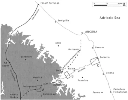
The considered area coincides with the westernmost of the sampling zones investigated by Ghent University in the context of the Potenza Valley Survey project (fi g. 1). Although not a real mountain area, it is located at the foot of the hilltops of Monte Primo and Monte Castel Santa Maria, where the valley widens beyond the narrow Pioraco gorge, through which the river, exiting from the Umbria-Marche Apennines, enters into an intermediate basin (fi g. 2). This sample zone was not arbitrarily chosen. It is still indeed a very hilly landscape (between 300 and 500 m high), but here the Potenza valley shows for the fi rst time, from the river sources westwards, enough arable land for widespread human settlement. The micro-region is situated on the crossroad of two intramontane corridors. The fi rst is the Potenza valley, which, oriented east to west, links the Apennines with the Adriatic coast. The second one gives passage from the Colfi orito area in the south to the Esino valley northwards. Both corridors, which cross each other southwest of Castelraimondo, have played an important role since the proto-history of the region6. The later
Roman roads, in fact, retraced the same natural communication routes, with some infrastructural arrangements, the tracing of adjustment paths and the opening of new connecting ways. At the western edge of the considered area,
centrale tra romani e longobardi (III-VIII sec.), organized in Spoleto in 2012 and to the congress Economia e territorio nell’Adriatico centrale tra tarda Antichità e alto Medioevo (IV-VIII secolo)
held in Ravenna in 2014. See, respectively, Cirelli, Diosono, Patterson 2015 and Cirelli, Giorgi, Lepore, in press.
3 I refer to Virgili 2014.
4 Moscatelli 2014, with previous bibliography. 5 Dall’Aglio 2004, p. 91.
there is Pioraco, located in correspondence to the Roman center Prolaqueum, a
mansio along the road site of the main via Flaminia, which, connecting Nuceria
to Ancona7, traversed the Potenza Valley until the Roman town of Trea. At the
extremes of the important north-south passageway are situated the towns of Camerino, positioned on the dorsal between the Potenza and the Chienti valley, and Matelica, located in the northern side of the intermediate basin, alongside the Esino river. Both of these towns originate from the Roman municipia
Camerinum and Matilica, respectively.
Rural settlements and towns between Late Antiquity and Early Middle Ages: the state of the art
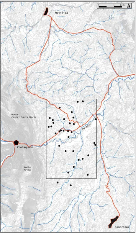
The systematic survey in the upper-Potenza valley, combined with fi eld-checks of crop and soil marks traced through aerial photography as well as using information from previous fi nds in the area, allowed the defi nition of 34 sites as non-problematic Roman “settlement sites,” based on the presence of artifact scatters and classifi ed within the site typology8 (fi g. 3).
The number of identifi ed Roman sites characterizes this area as the one with the highest density pattern among the three transect zones of actually surveyed fi elds.
As well noted for all the respective territories, the concentration of rural sites often corresponds to the contact areas of different landscape types, such as the border zones between the valley bottom and the hill slopes, where the advantages of the natural environment could be used.
In this sense, in the upper Potenza valley sample area, the large Roman settlements were mainly situated around the ca. 375 m – 405 m contours, where inhabitants profi ted from the abundant water springs.
The study of the archaeological materials, even considering the possible variables that enter into the recognition of pottery types due to poor diagnostics for some historical periods, led to the insertion of the chronological dimension needed for a full understanding of site dispersion in Roman times. Summarizing the already published PVS project results, the most marked occupation of the territory has been detected from the fi rst century B.C. to the second century A.D. In the third century, a sort of decline both of the existing settlements and in the creation of new rural units should have occurred. The fourth century seems to document an economic recovery, with a possible reoccupation of previous rural sites and a new intensive exploitation of the agricultural resources of this landscape, whose frequentation is testifi ed until the second half of the fi fth
7 Itinerarium Antonini 310, 5-7; 311, 5 ; 312, 1-6.
century, on the basis of the latest imported ceramic evidence. The detection of pottery concentrations dated from the tenth century onward led to the discovery of three medieval hilltop sites (tab. 1).
In Roman times, the considered rural sites were located within the
municipales agri of Matilica (north of the Potenza river) and Camerinum (south
of the Potenza river).
The published data concerning Matilica, in light of the latest interpretation of the fate of Roman towns in Picenum during Late Antiquity, seems to testify of a substantial continuity of occupation for the urban center9. The town was a
bishop’s see between the forth and the sixth century10. A proper medieval core
has been recognised within the medieval city walls, more or less corresponding to the Roman circuit. This focal area is located around the pieve, attested to since the thirteenth century on the Civita place. Earlier phases of frequentation, archaeologically documented inside or in connection with Roman buildings, have been attributed to the early Middle Ages and soon after the tenth century.
New stratigraphical data, available for Camerinum thanks to rescue excavations of urban archaeology directed by the Soprintendenza Archeologica
delle Marche, follow the transformation of some zones situated inside the Roman
walls from Late Antiquity to the present era11. They prove the topographical
continuity of the city, which has been a bishop’s see without interruption since the second half of the fi fth century. The role of the town in the framework of the Duchy of Spoleto is an evidence for considering the urban center as the essential reference for the settlement organization of the territory.
The positive fate of the two Roman towns, even within the changed economic and historical conditions and the strengthening of the political role of
Camerinum, is tightly linked to the substantial persistence of the surrounding
road network.
Finally, the strategic position is an additional clue in favor of the continuity of life of Prolaquaeum, the last Roman center in the considered territory12.
The archaeological discoveries in the area of the present urban center, only mentioned by the Itinerarium Antonini in connection with the side road via
Flaminia per Picenum ad Anconam13, describe a consistent settlement whose
persisting importance seems demonstrated by the pieve, which is situated at the eastern edge of the ancient town in correspondence with the Roman baths. Although according to the available documentary sources, the church is attested for the fi rst time only in the twelfth century, on account of the saint venerated
9 For the state of the art of the current research on the three here considered urban centers, see
Virgili 2014, pp. 28-29 and 35-38. About Matilica, see Biocco 2000 and Biocco et al. 2010.
10 Lanzoni 1927, p. 489.
11 See Silvestrini, Antongirolami, D’Ulizia 2014; Virgili, Melia 2015; Antongirolami, Frapiccini
in press; Frapiccini, Virgili in press.
12 Giuliodori 1993. 13 Biocco 2008.
there, St. Vittorino, the origin of the place of worship seems to date back to the early Middle Ages14.
New data from the Potenza Valley Survey project
The study of the pottery collected has revealed that one third of the Roman settlements detected in the upper Potenza Valley experienced a continuity of occupation until Late Antiquity (fi g. 4).
The now available overall view allows for a signifi cantly better understanding of the commercial traffi c of Mediterranean products in the different zones of the region between the forth and the seventh centuries. The imported ceramics, in fact, reached the coastal colony Potentia, possibly through cabotage routes, which fi rst connected the port of Ravenna to Ancona15. The comparison with
the ceramic material gathered during the fi eld surveys in the upper and middle Potenza valley shows the degree of penetration of these goods in the inland areas.
Concerning the pottery imported from North Africa, besides amphoras, lamps and cooking ware, the African Red Slip ware represents the better quantifi ed class. If in the whole river valley the production D is predominant, the downward trend of the amount of ARS fragments is notable, proceeding from the lower to the upper valley, with fragments attestations amounting, respectively, to the 65.31, the 22.45 and the 12.24 % of the total number. The latest forms found in the coastal area, however, never arrived in the upper valley, where the most recent fragments of ARS collected dated to the fi fth century. Even the imports of cooking ware identifi ed during the excavations and the surveys carried out in the colonia of Potentia, which testify to a trade connection with north-eastern Italy (Po region) that lasted until the second half of the sixth century, did not penetrate the inland areas16.
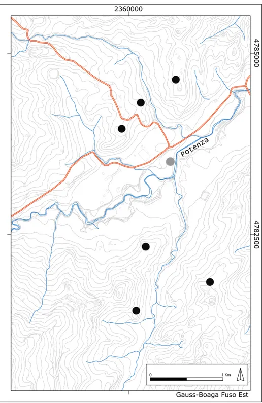
Compared with the catalogue of sites published in 2006, it could be ascertained that three of the rural Roman settlements occupied until Late Antiquity were frequented also during the early Middle Ages: one of them is located north of the Potenza river, in the north-eastern corner of the considered sample area, while the two others are situated southward, respectively within the actual municipality of Pioraco and Camerino. These settlements are all on hilltops or on high slopes areas, overlooking the valley below and in good visual relationship with the surrounding sites (fi g. 5).
14 Virgili 2014, pp. 35-36; Del Lungo 2004, p. 165. 15 As last, see Carboni, Vermeulen in press.
16 For the detailed description of local and imported productions of cooking ware from
Site nr. 69, Casa Matta (fi g. 6)
This site is located north of the Strada comunale di Brondoleto, in the municipality of Castelraimondo, on a hill and eastwards-oriented slope along the Rio Cimarolo, at an altitude of around 390 m a.s.l., directly overseeing the Potenza plain. It was detected by a systematic survey conducted in 2000 by the PVS project team.
The site, which presents a perifocal articulation composed of fi ve different concentrations very close to each other, extends on a surface of 3,000 m2 in total and has been interpreted as a rural settlement defi ned as Type 3 (large farm or villa) according to Vermeulen-Verdonck’s classifi cation17.
On the basis of the pottery collected, mixed with building material (tiles, sand and limestone pieces), in the different outcrop areas, the occupation consisted of an area inhabited from the Republican and early Imperial period up to the fourth century A.D., as attested by the ceramic fragments found in the large upper concentration (nr. 69B). Just within this zone and the southern, probably colluviated concentration (site nr. 69E), there were abundant high medieval fi nds.
The settlement is located almost exactly at the middle point of a unique alignment, parallel to the stretch of road here traversing the Potenza valley, between the two hilltops sites nr. 53/78 (Casa Cammarello) and nr. 71 (Seano). Signifi cant are the proximity and the connection reciprocal of the sites, as attested by the GIS viewshed analysis performed.
The fi rst settlement was detected in a zone bordering a house on top of the hill westward (408 m a.s.l.), originally situated between the Brondoleto stream and the main road conducting to Matilica. Here two concentrations of pottery and stones, mostly pebbles, were found, located, respectively, at the two opposite sides of the modern house. They denote the presence of a long-lasting rural settlement, frequented since the Imperial time through medieval and post-medieval times.
The second site, revealed by a large outcrop returning only Medieval pottery (seventh to eleventh century), was located at the small hilltop hamlet Seano (420 m a.s.l.), inside the topographical basin limited by the Rio Cimarolo on the west side. It coincides with a dark greyish brown earth and contains numerous fragments of limestone blocks and rubble. The chance discoveries during works on a house in 1961, which brought a female portrait of Severan Age to light at this location, as well as a male bust, document a possible continued occupation of the site since Roman times18.
17 Verdonck, Vermeulen 2004, 179-181.
Sites nr. 37 and 38, Le Caselle (fi g. 7)
The site nr. 38 is located beside the Rio or Selvazzano stream in the municipality of Pioraco, on a hilly ridge at an altitude of around 400 m a.s.l. It was detected by a systematic survey conducted in 2000 by the PVS project team.
The settlement consists of a large concentration (2,400 m2) of roof tiles and
other building material together with a large amount of Roman pottery. This site, classifi ed as Type 3 (large farm or villa), might extend more widely. It could be related to another large concentration (site nr. 37, 5,500 m2), located
northwards at the foot of a steep slope. The fi nds area was plausibly formed by an accumulation of material from the top of the hill, at the present occupied by the modern farm Le Caselle.
The ceramic fragments collected in both concentrations testify to the occupation of the sites in the following chronological ranges: fi rst century B.C. through second century A.D., fourth to fi fth century A.D., and seventh to ninth century A.D.
Site nr. 58, Mergnano S. Pietro (fi g. 7)
This site is located on a south-west oriented slope, just at the north of the
Mergnano S. Pietro hamlet in the municipality of Camerino. The settlement is
at an altitude of 444 m a.s.l. It was detected by a systematic survey conducted in 2000 by the PVS project team.
The artifact scatter (ca. 4,000 m²) spread over the fi eld and consisted of building materials and Roman pottery from the fi rst century B.C. to the fourth or fi fth century A.D., and it has been interpreted as a Type 3 settlement (large farm or villa).
Within a concentration of sand and limestone, some proto-historic fi nds were discovered, indicating a possible proto-historic settlement. A fair amount of early medieval ware was also present. The favorable location of the considered sites, overlooking each other from the opposite side of the Rio or Selvazzano stream, explains the long frequentation attested since pre-historic times through Late Roman age and, in continuity, until the period comprised between the seventh and the ninth centuries.
South of the site nr. 37, the PVS project’s investigations carried out in 2000 located two concentrations (sites nr. 60 and 61), the lowest of which (nr. 60) possibly consisted of colluviated materials, which came down from the top of the small hillock where site 61 was situated, at the altitude of ca. 390 m a.s.l., in locality Colle Maggio19 Both concentrations returned potsherds dated from
the tenth century.
Despite the three settlement clusters (sites nr. 60-61, nr. 37-38, nr. 58) seem to be located according to an evident connection in terms of visibility – each one being ascertained at the corner of an ideal equilateral triangle – at present there are no data supporting their contemporary occupation during the high Middle Ages.20
Finally, regarding the vitality of the whole considered micro-region in the high Middle Ages, it is signifi cant to remark the presence, attested on documentary basis, of a church registered among the properties of Fiastra Abbey from 967 to 1118 A.D.: St. Angelo in Lanciano21. The church, to be placed in proximity
of the modern hamlet Borgo Lanciano (Castelraimondo) or in coincidence with the nearby late medieval castle22, is situated along the Potenza valley in a
strategic point, in the vicinity of the cross-roads of the diverticulum of the via
Flaminia and the north-south connection between Camerino and Matelica. Some preliminary data about the pottery fi nds
North of the Potenza river, the evidence for a frequentation of the site nr. 69 during Medieval times is based on the outcrops of a good amount of common ware dated from tenth to eleventh century and later. Most of this common ware consisted of the typical pottery assemblage accounted for in this period in central Italy, thereby associating the regions of Tuscany, Romagna, Umbria and Marche in a common background of cultural, alimentary and economic traditions23. This association concerns the basket shaped cooking vessels so
called “Paioli a cestello,” as well as medium and large storage jars featuring an everted rim, strap handle attached to the rim and a possible spout on the shoulder24.
20 The most recent materials collected during surveys in the northern sites dated to the
seventh-ninth century, while the ceramic vessels found in the concentrations located on Colle Maggio consist of the forms diffused only from the tenth century onward. Nevertheless, the survival of the Roman praedial toponym in the present denomination of Mergnano (San Pietro) village seems to suggest a continued site occupation.
21 R.F. III, nr. 404 and R.F. V, Nr. 1318. 22 Virgili 2014, p. 49.
23 De Marinis 1999.
24 A large quantity of this homogenous pottery assortment, testifying to a standardized and
organized ceramic production integrated into an interregional market, was fi rstly brought to light at the excavations of Matelica (loc. Castellana) and of Sarnano (Mercando 1970, 394-434, Profumo 1990). Following discoveries, steadily increasingly thanks to stratigraphical excavations and survey investigations in the Marche region, led to point to a local production (Profumo 2004, p. 173). A fair amount of paioli a cestello were discovered in 2012 within the layers fi lling a medieval trench, come to light in Tolentino (MC), during the renovation works of the theatre Nicola Vaccaj: <http:/ www.archeologia.beniculturali.it/index.php?it/142/scavi/scaviarcheologici_4e048966cfa3a/333>, 12.11.2015.
Concerning the transitional period between Late antiquity and early Middle Ages, the extreme fragmentary state of the ceramic fi nds did not allow for the recognition of any fragment of the typical Lombard burnished pottery with stamped decoration.
Nevertheless, the detection of many potsherds possibly dated from the seventh to the ninth century are of particular interest. These fragments can be easily inserted in the category of “light clay unglazed ware” decorated with incised lines running in bands, as well as horizontal motifs sometimes taking a wavy form (fi g. 8). Specifi cally, the fragments are of common pottery vessels, always collected in a highly fragmented state, for which little can be discerned from a morphological point of view, but that may offer more precise information in technical terms25.
This kind of decoration is vastly attested to in the Mediterranean world, and particularly in Italy26. But beyond any generic formal comparisons, this
group of light and moderately hard clay pottery is fully part of the specifi c class recognized on occasion in the study of Comacchio’s stratigraphies27. Besides the
typical combed decoration, these include mainly closed forms, mostly with two handles and generally dated from the end of the seventh to the ninth century A.D. Through the analysis of the fabric type, the fragments were assigned to the same group of a larger quantity of potsherds, consisting of handles, bottoms and fragments of walls without decoration that were otherwise unclassifi able.
It is important that future petrographical analysis establish the possible production site of the collected fragments of “light clay unglazed ware.” At present, on the basis of autoptic considerations, the most convincing comparisons can be done with the vessels diffused in the Po region as well as with the ones coming from Rome and Latium.
If the origin of this kind of imported pottery were confi rmed, it would be further evidence of the strategic and dynamic role of the upper Potenza valley’s intermediate basin and of its road connections passing through the Umbria region, once this area became part of the Spoleto Duchy.
The presence of this pottery appears to be more signifi cant in sites where the concerned fragments result to be the most recent potsherds identifi ed, after the Late Roman pottery.
25 The incising decorations, with bundles of wavy lines often associated with bands of horizontal
lines, were engraved by a multi pointed tool. These decorations are almost always located on the shoulder of close vessels. The fabric is generally hard and well cooked, with a fi ne texture. The walls are relatively thin. The external surface is shaped accurately with few and regular lathe signs. On the surface of some fragments, a lightening effect is noticeable. It seems most due to a cooking effect than to a slip-coating presence.
26 The comparisons panorama shows a formal link with Central Italy, mainly Latium, with the
contexts of Ostia and Mola di Monte Gelato and Rome, as attested by the Crypta Balbi material. Some analogies occur even with the central and southern Adriatic area, with the vessels produced at Castellana-Piano Leone di Pianella (PE) and Otranto, fondo Militello. For more comparisons and referred bibliography, see Negrelli 2007, pp. 313-326.
This is the case of the site nr. 58, detected next to Mergnano S. Pietro and of the site nr. 37 Le Caselle.
Conclusions
The considered cases allow for a better understanding of the evolution of the rural settlements in the upper Potenza valley between Late Antiquity and the early Middle Ages, always taking into account the low visibility of the period in survey investigations.
A series of clues associated with the recognition of new pottery markers, possibly dating to the period between the end of African and Eastern imports and the emergence of new forms characteristic from the tenth century in central Italy, allows for the reconstruction of a scenario of substantial continuity within homogenous topographical contexts.
The data presented here may appear obvious, if they are evaluated in light of the geographical framework and the undoubted persistence of the urban centers in the territory where the investigated sites are located.
Generally, the economic criteria are the most signifi cant when determining the continued life of a Roman town. As Chris Wickham stated, in the transition period under scrutiny, a strong impulse to urbanism was, simply, the choice that aristocrats, whose wealth derived from their activity as landowners, could exercise to live in urban centres.28
At present, however, it is diffi cult to assess the real modes of this continuity, both in urban and rural contexts, namely, the real living conditions and the population density. And, of course, we should be able to determine the differences that existed during different ages between cities, in this case
Matilica and Camerinum, in terms of urban hierarchy, political signifi cance
and economic infl uence.
In the sample area coinciding with the upper Potenza valley, the PVS survey started with investigating the settlement patterns located in the countryside.
What is more and more clear is that studying the towns includes the study of the landscape with which the towns interact and vice versa. It means considering the “container” together with the “content”29, since the survival of the cities
and the economic endurance of their territory were mutually dependent.
This implies the necessity of overcoming the geographical framework represented by the “tout-court” river valley territory for focusing the attention on the relationship between town and countryside, from the countryside
28 Wickham 2005, p. 594. 29 Citter 2012.
perspective, such as the sustainability of the demographic growth of towns and the diachronic developments in the settlement chamber of which towns are part30.
Archaeologically, a way to understand the change of rural settlement patterns in the upper Potenza valley during the considered transition period is to combine and compare the data produced through survey investigations in the rural sites with the ones that have merged (or will be brought to life) from the excavation of the stratigraphies related to the different phases of life at the concerned cities Camerinum and Matilica, as well as Prolaqueum. In those cities lived the main users of the imported vessels, there were, possibly, the pottery workshops of the local productions.
Only the matching of all the different frames can lead to the restitution of the picture in its complexity and to the comprehension of the destructuration process patterns that necessarily occurred in the rural settlements, as well as in the the urban centres, before their subsequent reconstruction, also in contexts of prolonged duration or even uninterrupted continuity.
References / Riferimenti bibliografi ci
Antongirolami V., Fapriccini N. (in press), Le aree funerarie tardoantiche dal
centro storico di Camerino, in Cirelli, Giorgi, Lepore (in press).
Boccanera, G. Corradini S. (1970), Ricerche sull’età preromana e romana
nel maceratese, in Atti del IV Convegno di Studi Maceratesi (San Severino
Marche, 10 novembre 1968), Macerata, pp. 65-125.
Biocco E. (2000), Citta romane. Matelica, Roma: L’Erma di Bretschneider. Biocco E. (2008), Il diverticolo della Flaminia ab Nuceria ad Anconam nel
territorio di Pioraco (Prolaque), in Spazi, forme e infrastrutture dell’abitare,
a cura di L. Quilici, S. Quilici Gigli, Atlante tematico di Topografi a Antica 18, Roma: L’Erma di Bretschneider, pp. 81-91.
Biocco E., Casadei L., Sabbatini, T. (2010), Matelica (MC), «Picus. Studi e Ricerche sulle Marche nell’Antichità», 39, pp. 297-323.
30 Bintliff 2013. About the recall to the German historical geography or Landeskunde that
showed, already by the 1930’s, the necessity of pursuing demographic dynamics and settlement shifts at the micro-landscape or Siedlungskammer level, in order to comprehend historical processes on the ground, see Bintliff 2000 and Brogiolo 2005, for the Italian context. In the Marche region, a restitution of topographical scopes within which the sites hierarchy is redrawn in a framework of substantial continuity, between Roman times to Middle Ages, is offered by the results of the RIMEM project. See Moscatelli 2014, with previous bibliography. For a comparison with the ager fi rmanus, another sector of the region ruled by the Lombards, where the longue durée of the economic structures of the countryside is refl ected in the political and administrative stability of Firmum, see Menchelli 2014 and Menchelli, Picchi 2015.
Bintliff J. L. (2000), Deconstructing the sense of place? Settlement systems,
fi eld survey, and the historic record: a case-study from Central Greece,
«Proceedings of the Prehistoric Society», 66, pp. 123-149.
Bintliff J. L. (2013), Catchments, settlement chambers and demography, in
Counterpoint: Essays in Archaeology and Heritage Management in Honour of Professor Kristian Kristiansen, a cura di S. Bergerbrant, S. Sabatini, BAR
International series 2508, Oxford : Archaeopress, pp. 61-69.
Brogiolo G.P. (2005), Risultati e prospettive della ricerca archeologica sulle
campagne altomedievali italiane, in Dopo la fi ne delle ville. Le campagne dal VI al IX secolo, a cura di G.P. Brogiolo, A. Chavarria, M. Valenti, Atti
del 11° Seminario sul Tardo Antico e l’Alto Medioevo (Gavi, 8-10 maggio 2004), Mantova: SAP, pp. 7-16.
Carboni F., Vermeulen F. (in press), Il ruolo della colonia costiera di Potentia
nell’ambito delle rotte adriatiche tra IV e VII secolo d.C., in Cirelli E., Giorgi
E., Lepore G., a cura di (in press).
Cirelli E., Diosono F., Patterson H., a cura di (2015), Le forme della crisi.
Produzioni ceramiche e commerci nell’Italia centrale tra romani e longobardi (III-VIII sec.), Atti del convegno (Spoleto-Campello sul Clitunno, 5-7
ottobre 2012), Bologna: Ante Quem.
Cirelli E., Giorgi E., Lepore G., a cura di (in press), Economia e territorio
nell’Adriatico centrale tra tarda Antichità e alto Medioevo (IV-VIII secolo),
Atti del convegno (Ravenna, 28 febbraio – 1 marzo 2014), Bologna: Ante Quem.
Citter C. (2012), Archeologia delle città toscane nel Medioevo (V-XV secolo).
Fotogrammi di una complessità, Mantova: SAP.
Cracco Ruggini L. (2004), Come e perchè è “esploso” il tardoantico, «Studi
storici, Rivista trimestrale dell’Istituto Gramsci», 45, 1, pp. 15-23.
Del Lungo S. (2004), Luoghi del sacro e culto dei santi nella Marca, in Ascoli
e le Marche fra tardoantico e altomedioevo, a cura di E. Menestò, Atti del
convegno (Ascoli Piceno, 5-7 dicembre 2002), Spoleto: Centro Italiano di Studi sull’Alto medioevo, pp. 141-200.
De Mariniis G. (1999), “I pozzetti medievali dell’ ex Palazzo Chierichetti e
il loro contesto, in Archeologia a Matelica. Nuove acquisizioni”, catalogo
della mostra (Matelica, Palazzo Ottoni, marzo-ottobre 1999), Matelica: Sopr. Arch. per le Marche, pp. 87-89.
Frapiccini N., Virgili S. (in press), Trasformazione della Camerinum romana tra
tarda antichità e alto medioevo, in Cirelli E., Giorgi E., Lepore G., a cura di
(in press).
Giuliodori M. (1993), Per l’urbanistica di Prolaqueum, regio VI. Contributo
preliminare, in Monumenti e cultura dell’appennino in età romana, Atti del
convegno (Sestino, 12 novembre 1989), Roma: L’Erma di Bretschneider, pp. 65-81.
medievali nell’entroterra marchigiano, «Archeologia Medievale», 34,
pp. 134-140.
Karr E.H. (1961), What is History. The George Macaulay Trevelyan lectures
delivered in the University of Cambridge January-March 1961, London:
Penguin Book.
Konestra A., Moscatelli U., Virgili S. (2011), Progetto R.I.M.E.M. Rapporto
preliminare sulle campagne di ricognizione 2008-2009-2010, «Il Capitale
Culturale», 2, pp. 299-325.
Lanzoni F. (1927), Le diocesi d’Italia dalle origini al principio del sec. VII, Faenza: F. Lega.
Menchelli S. (2014), Dal tardo antico al Medioevo: le ville e le pievi nei
paesaggi di Firmum Picenum/Fermo (Marche meridionali), in Studi di storia degli insediamenti in onore di Gabriella Garzella, a cura di E. Salvatori,
Ospedaletto (PI): Pacini, pp. 97-104.
Menchelli S., Picchi G. (2015), Ceramiche tardoantiche dal Piceno meridionale, in Cirelli E., Diosono F., Patterson H., a cura di (2015) pp. 329-338.
Mercando L. (1970), Matelica (Macerata): rinvenimenti di età gallica e
medievale, «Notizie degli Scavi di Antichità», 24, pp. 394-434.
Mercando L, Paci G., Brecciaroli Taborelli L. (1981), Forme di insediamento nel
territorio marchigiano: ricerca preliminare, in Società romana e produzione schiavistica. 1. L’ Italia: insediamenti e forme economiche, a cura di A.
Giardina, A. Schiavone, Bari : Laterza, pp. 311-348.
Moscatelli U. (2014), Transizioni. Aspetti delle campagne dell’entroterra
maceratese tra tardoantico e altomedioevo, in Atti del IV Convegno Internazionale di Studi Veleiati (Veleia-Lugagnano Val d’Arda, 20-21
settembre 2013), a cura di P.L. Dall’Aglio, C. Franceschelli, L. Maganzani, Bologna: AnteQuem, pp. 379-395.
Negrelli C. (2007), Vasellame e contenitori da trasporto tra tarda antichità ed
altomedioevo: l’Emilia Romagna e l’area medio-adriatica, in La circolazione delle ceramiche nell’Adriatico tra tarda antichità ed altomedioevo, Atti del III
Incontro di Studio Cer.am.Is sulle ceramiche tardoantiche ed altomedievali (Venezia, 24-25 giugno 2004), a cura di S. Gelichi, C. Negrelli, Mantova: SAP, pp. 297-330.
Negrelli C. (2012), Towards a defi nition of early medieval pottery: amphorae and
other vessels in the northern Adriatic between the 7th and the 8th centuries,
in From one sea to another. Trade places in the European and Mediterranean
Early Middle ages, Proceedings of the International Conference (Comacchio
FE-Italy, 27th-29th March 2009), a cura di S. Gelichi, R. Hodges, Turnhout:
Brepols, pp. 415-438.
Percossi E., Pignocchi G. (2006), La vallata del fi ume Potenza: dalla via Flaminia
al mare, in Percossi E., Pignocchi G., Vermeulen F., a cura di (2006), pp. 12-43.
Percossi E., Pignocchi G., Vermeulen F., a cura di (2006), I siti archeologici
Profumo M.C. (1990), Sarnano: area archeologica medievale, in Archeologia
nel Maceratese:nuove acquisizioni, a cura di G. de Marinis, G. Paci, E.
Percossi, M. Silvestrini, Macerata: Fondazione Cassa di Risparmio Provincia di Macerata, pp. 300-307.
Profumo M.C. (2004), Ceramica altomedievale nelle Marche, in La ceramica
altomedievale in Italia, a cura di S. Patitucci Uggeri, Quaderni di archeologia
Medievale 6, Firenze: All’Insegna del Giglio, pp. 163-176.
Silvestrini M., Antongirolami V., D’Ulizia A. (2014), Archeologia urbana a
Camerino (MC). Dati preliminari per la carta archeologica della città alla luce delle recenti scoperte, in Amore per l’Antico dal Tirreno all’Adriatico, dalla Preistoria al Medioevo ed oltre. Studi di Antichità in ricordo di Giuliano de Marinis, a cura di G. Baldelli, F. Lo Schiavo,vol. 2, Roma: Scienze e Lettere,
pp. 659-670.
Verdonck L., Vermeulen F. (2004), A contribution to the study of Roman rural
settlement in Marche, «Picus. Studi e Ricerche sulle Marche nell’Antichità»,
24, pp. 161-229.
Vermeulen F., Boullart C. (2001), The Potenza valley Survey: Preliminary
report on fi eld campaign 2000, «BaBesch. Annual Papers on Mediterranean
Archaeology », 76, pp. 1-18.
Vermeulen F., Mlekuz D. (2012), Surveying an Adriatic valley: a wide area view
on early urbanization processes in Northern Picenum, in Urban Landscape survey in Italy and the Mediterranean, a cura di F. Vermeulen, Oxford:
Oxbow Books, pp. 207-222.
Vermeulen F., Verreyke H., Carboni F. (2015), Produzioni ceramiche, scambi
commerciali e modifi cazioni urbane nell’Adriatico centrale fra il III e il VI secolo d.C. Nuovi dati da Potentia, in Cirelli E., Diosono F., Patterson H., a
cura di (2015), pp. 339-349.
Verreyke H., De Paepe M. (2009), Late Roman Burnished Ware in Adriatic
Italy: the Archaeometric Evidence for Trade from the Central Adriatic Town of Potentia (Porto Recanati, Italy), «Journal of Field Archaeology», 34, 2,
pp. 185-193.
Verreyke H., Vermeulen F. (2009), Tracing Late Roman Rural Occupation
in Adriatic Central Italy, «American Journal of Archaeology», 113, 1, pp.
103-120.
Virgili S. (2014): Insediamenti civili e religiosi nella media e alta valle del
Potenza, Firenze: All’Insegna del Giglio.
Virgili S., Melia F. (2015), Camerinum tra tarda antichita e alto Medioevo: dati
preliminari dagli scavi di emergenza di P.za Cavour, in Cirelli E., Diosono
F., Patterson H., a cura di (2015), pp. 321-327.
Wickham Ch. (2005), Framing the Early Middle Ages. Europe and the
Appendix*
Fig. 1. Location of the PVS survey sample areas in the Potenza valley (A: upper, B: middle, C: lower valley)
Fig. 2. The upper Potenza valley beyond the Pioraco gorge. View of Monte Primo and Monte Castel Santa Maria, from the east
* All photographs and images, unless otherwise expressly stated, are the copyright of the
Fig. 3. The Roman rural sites detected by the PVS project in the upper valley sample area, located in the concerned geographical framework (Roman roads and urban centers)
Fig. 5. Early Medieval and Medieval sites detected by the PVS project in the upper valley sample area. The grey dot indicates the possible location of St. Angelo in Lanciano church
Fig. 6. Location of the Medieval sites in the Northern part of the upper Potenza valley sample area
Fig. 7. Location of the Medieval sites in the Southern part of the upper Potenza valley sample area
eum edizioni università di macerata