Full Terms & Conditions of access and use can be found at
https://www.tandfonline.com/action/journalInformation?journalCode=tjom20 ISSN: (Print) (Online) Journal homepage: https://www.tandfonline.com/loi/tjom20
Geomorphological evidence of debris flows and
landslides in the Pescara del Tronto area (Sibillini
Mts, Marche Region, Central Italy)
Piero Farabollini , Pierfederico De Pari , Marco Emanuele Discenza ,
Mariacarmela Minnillo , Cristiano Carabella , Giorgio Paglia & Enrico
Miccadei
To cite this article: Piero Farabollini , Pierfederico De Pari , Marco Emanuele Discenza , Mariacarmela Minnillo , Cristiano Carabella , Giorgio Paglia & Enrico Miccadei (2020):
Geomorphological evidence of debris flows and landslides in the Pescara del Tronto area (Sibillini Mts, Marche Region, Central Italy), Journal of Maps, DOI: 10.1080/17445647.2020.1827055 To link to this article: https://doi.org/10.1080/17445647.2020.1827055
© 2020 The Author(s). Published by Informa UK Limited, trading as Taylor & Francis Group on behalf of Journal of Maps
View supplementary material
Published online: 30 Sep 2020. Submit your article to this journal
Article views: 248 View related articles
Geomorphological evidence of debris
flows and landslides in the Pescara del
Tronto area (Sibillini Mts, Marche Region, Central Italy)
Piero Farabollini a, Pierfederico De Parib, Marco Emanuele Discenza b, Mariacarmela Minnillob,
Cristiano Carabella c, Giorgio Paglia cand Enrico Miccadei c
a
School of Science and Technology, Università degli Studi di Camerino, Camerino, Italy;bGeoservizi s.r.l. Ripalimosani, Italy;cDepartment of Engineering and Geology, Università degli Studi‘G. d’Annunzio’ Chieti-Pescara, Laboratory of Tectonic Geomorphology and GIS, Chieti Scalo, Italy
ABSTRACT
In this paper, a geomorphological map of Pescara del Tronto area (Sibillini Mts, Marche Region) is presented. The work focuses on the geomorphological analysis performed in a zone strongly struck by the 2016–2017 seismic sequence of Central Apennines. The geomorphological map (1:7,500 scale) was obtained through an integrated approach that incorporates geological-geomorphological field mapping and geomorphological profile drawing, supported by air-photo interpretation and GIS analysis. The main purpose of the work is to describe a geomorphological approach for representing and mapping the evidence of several debris flows and landslides recognized in the framework of seismic microzonation (SM) activities. Finally, in order to elevate geomorphological maps into effective tools for land management and risk reduction, it could provide a scientific and methodological basis to demonstrate that accurate mapping provides important information, readily available for local administrations and decision-makers, for the implementation of sustainable territorial planning and loss-reduction measures.
ARTICLE HISTORY Received 9 July 2020 Revised 11 September 2020 Accepted 18 September 2020 KEYWORDS Geomorphological mapping; landslides; debrisflow; Pescara del Tronto; Marche Region
1. Introduction
Geomorphological mapping is regarded as a funda-mental technique of the discipline producing valuable base data for geomorphological and environmental research and practice. In detail, geomorphological maps can be considered graphical inventories of a landscape, depicting landforms and surface features (Dykes, 2008). The widespread distribution and extended graphical capabilities of Geographic Infor-mation Systems (GIS), as well as the availability of high-resolution remote sensing data and Digital Elevation Models (DEMs), has led to the recent rejuve-nation of the methodologies of mapping. Geomorpho-logical maps can act as a preliminary tool for land management and geological risk management, as well as providing baseline data for other applied sectors of environmental research and studies (Bocco et al., 2001; Dramis et al., 2011; Lee, 2001; Otto & Smith, 2013). Moreover, these thematic maps represent an objective and multi-scalar method for the represen-tation of the landscape that can be of great benefit to a wider community of users, including environmental analysts and planners (Smith et al., 2011).
The presented paper focuses on the geomorphologi-cal analysis and mapping of the evidence of debris flows and landslides recognized in the area of Pescara
del Tronto (Sibillini Mts, Marche Region), a zone strongly struck by the 2016–2017 seismic sequence of Central Apennines. From 24 August 2016, an impor-tant seismic sequence started in Central Italy and affected Marche, Abruzzo, Lazio, and Umbria regions,
covering an area approximately 6000 km2 large. The
sequence started with the main Mw 6.0 earthquake occurred between the municipality of Arquata del Tronto (Macerata, Marche Region) and Accumuli (Rieti, Lazio Region) and it was followed by more than 60,000 replicas with important seismic events
(Chiaraluce et al., 2017; ISIDE working group, 2016;
Liu et al., 2017). In detail, it was soon followed by the Mw 5.4 event close to Norcia (Perugia, Umbria Region), at about 10 km of epicentral distance from
the first shock and, then, the sequence migrated
north of Norcia, in NNW direction, where three strong shocks with Mw 5.4, 5.9, and 6.5, respectively, occurred at the end of October 2016; later, it moved south of Accumuli, in SSE direction, releasing other four major earthquakes with Mw ranging from 5.0 to 5.5 on 18 January 2017 (Laurenzano et al., 2019). Follow-ing the seismic sequence, damages were immediately registered and observed in several villages, with signifi-cant evidence in Pescara del Tronto area (Arquata del Tronto municipality, Ascoli Piceno, Marche Region).
© 2020 The Author(s). Published by Informa UK Limited, trading as Taylor & Francis Group on behalf of Journal of Maps
This is an Open Access article distributed under the terms of the Creative Commons Attribution License (http://creativecommons.org/licenses/by/4.0/), which permits unrest-ricted use, distribution, and reproduction in any medium, provided the original work is properly cited.
CONTACT Enrico Miccadei [email protected] Department of Engineering and Geology, Università degli Studi‘G. d’Annunzio’ Chieti-Pes-cara, Laboratory of Tectonic Geomorphology and GIS, Via dei Vestini 31, 66100 Chieti Scalo, CH, Italy
JOURNAL OF MAPS
The severity of damage is evident both in terms of fatalities and building collapses, as well as in terms of heavy surface effects (i.e. debris flows and landslide) induced by the seismic sequence (Amanti et al., 2017; Martino et al., 2019;Masi et al., 2016;Vignola et al., 2019). Central Italy is characterized by a very frequent seismic activity and high instability hazard, highlighted by ground failure including landslides and rockfalls (Livio & Ferrario, 2020; Martino et al., 2014). Land-slides have been considered as secondary effects
induced by earthquakes (Ausilio et al., 2018; Keefer,
2002; Lin et al., 2004; Vaz & Zêzere, 2016). These local phenomena can greatly increase the environ-mental, human, social, and economic impact of an earthquake. Recently, several studies have highlighted the importance of these secondary effects on damage
and loss of human life (e.g. Konovalov et al., 2019;
Nowicki Jessee et al., 2020;Turner, 2018). Generally, landslide phenomena play an important role in the landscape evolution, occurring in relation to peculiar morphological, geological, and climatic characteristics, and to destabilizing effects induced by human and seis-mic activity (Bozzano et al., 2020;Calista et al., 2019; Carabella et al., 2019; Martino et al., 2020) and rep-resent a serious hazard worldwide and in Italy (Aleotti & Chowdhury, 1999;Aringoli et al., 2010;Dramis et al., 2001;Farabollini et al., 1995;Glade et al., 2012;Marsala et al., 2019; Peruccacci et al., 2017; Quesada-Román et al., 2019;Tanyaş et al., 2017). Following the main
event on 24 August 2016,field surveys were
immedi-ately launched, also in Pescara del Tronto area, in order to evaluate the effects of the earthquake: the focus of the survey was to detect both the effects related to the reactivation of the active faults (i.e. primary) and the seismic shaking (e.g. landslides and fracturing in soil and rock), generally classified as secondary effects. Some of these studies have already been the subject of recent scientific publications or reports (Aringoli et al., 2016,2018;Civico et al., 2018;Emergeo
et al., 2016;Farabollini et al., 2018,2019;Villani et al., 2019). The Pescara del Tronto area is located in the lower sector of the southeastern slope of Mt. Mac-chialta (1751 m a.s.l.), which drops down towards the Tronto River (650 m a.s.l.). The overall morphology is characterized of the slope by an articulated profile, concave in the upper middle section and slightly con-vex in the lower one, with an average slope of about 30°. According to previous studies performed in the framework of seismic microzonation (SM) activities
(Chiessi et al., 2019; ISPRA, 2017a,2017b), the
geo-morphological setting of the study area was widely altered increasing the possibility of triggering potential landslides. It is largely affected by debris flow channels and couloirs with debris discharge, suggesting the identification of a zonation of landslide susceptibility, organized in different classes marking low, medium, high, and very-high landslide susceptibility (Amanti et al., 2018). Detailedfield surveys allowed us to record and analyse the area in order to give a significant con-tribution to seismic risk mitigation for the purposes of understanding the triggering processes and for identi-fying areas that might be damaged by future seismic events. The main purpose of this work is to describe a detailed geomorphological approach for representing
and mapping the evidence of several debrisflows and
landslides observed and recognized in Pescara del Tronto area (Sibillini Mts, Marche Region) (Figure 1). This paper presents a main geomorphological map (1:7,500 scale) with its related geomorphological legend, supported and integrated with a detailed geo-logical-geomorphological cross-section.
2. Study area
The study area is located in a typical mountainous region of Central Apennines and it is set in the middle-high Tronto River valley, which incorporate a 115-km-long main river. The northernmost sector of
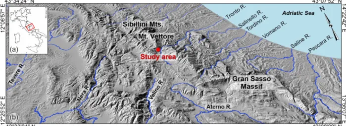
Figure 1.(a) Location map of the study area (red box) in Central Italy; (b) three-dimensional view (from 20 m DEM, SINAnet) of the Marche Region. The red dot indicates the location of the study area.
the area reaches the maximum altitudes in correspon-dence of the relief of Mt. Vettore, whose southeastern flank shows elevation values from 700 up to 2400 m a.s.l. The overall morphology is representative of the mountainous landscape dominated by N-S oriented ridges, with elevation ranging from 1700 to 2000 m a.s.l. interrupted by the Tronto River valley, where lower elevation (about 600 m a.s.l.) is reached. In detail, the study area is placed in the southern sector of Sibillini Mountains, with an impressive roughly N–S oriented thrust and fold belt, dissected by mainly striking NW–SE normal fault systems. In particular, Pescara del Tronto is located at the footwall of the N10° trending Sibillini Mountains thrust zone, at the Umbria-Marche border, bringing the Late Jurassic-Miocene carbonate succession onto the Messinian tur-biditic deposits of the Laga Formation (Centamore & Deiana, 1986; Pierantoni et al., 2013; Vignola et al., 2019). Its present-day structural framework derives from the interaction between preexisting (Miocene-Pliocene) contractional structures (e.g. folds and thrusts due to the emplacement of the Apennine chain) and Quaternary extensional faults (due to post-orogenic collapse), with (N)NW-(S)SE trending, associated to intramontane basins and present-day seismicity (Calamita & Pizzi, 1994;Pizzi et al., 2017; Tavernelli et al., 2004). The geomorphological setting is the result of a complex cyclic evolution that occurred in succeeding stages with the dominance either of mor-phostructural factors, linked to the conflicting tectonic activity and regional uplift, or morphosculptural fac-tors, linked to drainage network linear down-cutting and slope gravity processes (Cello et al., 1997; Farabol-lini et al., 1995;Gentili et al., 2017;Materazzi et al., 2010; Tondi & Cello, 2003). These factors refer to different morphogenetic processes, that have shaped and still model the area, mainly linked to litho-struc-tural features of the bedrock; Plio-Quaternary exten-sive tectonics and uplifting, as testified by the strong seismicity of the area; Quaternary climatic changes and recent anthropic activity (agriculture, urbaniz-ation, water regulurbaniz-ation, extraction of aggregates from the riverbeds, etc.), responsible for activating signifi-cantly faster erosion and intense accumulation pro-cesses (Aringoli et al., 2007;Coltorti & Dramis, 1990).
3. Methods
A detailed geomorphological analysis combined with field surveys, air-photo interpretation, and GIS analy-sis allowed the realization of the geomorphological map of Pescara del Tronto area.
Vectorial topographic data (1:10,000 scale) were retrieved from the Posizione di Funzione Urbanistica, paesaggio ed informazioni territoriali of Marche Region (https://www.regione.marche.it/Regione-Utile /Paesaggio-Territorio-Urbanistica/Cartografia).
Geological and geomorphological analyses were
based onfield mapping, integrated with available
lit-erature data (i.e. regional geological and
geomorpho-logical cartography available at https://www.regione.
marche.it/Regione-Utile/Paesaggio-Territorio-Urbani stica/Cartografia) and air-photo interpretation. A
detailedfield mapping was carried out to discriminate
lithological features and the type of and distribution of geomorphological landforms, especially landslides. The mapping was performed according to the guide-lines of the Geological Survey of Italy and AIGeo
(Ita-lian Association of Physical Geography and
Geomorphology) (ISPRA, 2007; ISPRA & AIGEO,
2018) and was also in accordance with the literature
concerning geomorphological mapping (e.g.Bozzano
et al., 2020;Calista et al., 2016;Chelli et al., 2016; Gus-tavsson et al., 2006;Miccadei et al., 2012; Seijmonsber-gen, 2013; Smith et al., 2011); the geomorphological legend used in this work was conceived based on the aforementioned Italian guidelines, in order to better represent the features of the study area.
4. Results
The enclosed map shows the main geomorphological features of the Pescara del Tronto area, as described in the following paragraph.
4.1. Geomorphological map
On the geomorphological map, the following litho-logical and geomorpholitho-logical elements are included. The bedrock includes lithologies referable to marine deposits, made up of calcareous rocks and siliciclastic turbiditic deposits. In detail, they consist of lime-stones, marly limelime-stones, cherty limestones and marls (Cretaceous-Eocene in age) related to the so-called Umbria-Marche stratigraphic succession (Cen-tamore & Deiana, 1986), from the Maiolica to the Sca-glia Rossa formation, overlapped on turbiditic terrigenous deposits, referable to the pre-evaporitic member of the Laga Formation (Messinian in age) and made up of some lithofacies associations: arenac-eous, arenaceous-pelitic, and pelitic-arenaceous (Pier-antoni et al., 2013). Quaternary continental deposits are also widespread in the area. Calcareous tufa
depos-its in ‘cascade facies’ and in ‘riffle and pool facies’
(Farabollini et al., 2004) outcrop in correspondence of the damaged village of Pescara del Tronto. Close to the bottom of the valley, gravel-sandy and sandy-silty alluvial deposits outcrop, incised and terraced by the Tronto river (first-order terrace); while, the cur-rentfluvial deposits mainly consist of calcareous grav-els, sands and subordinately blocks. Eluvial-colluvial cover is made up of sandy-clayey silts from brown to dark, generally massive, with common vegetal remains and local polygenic gravels of centimetric size.
The study area is characterized by several land-forms, heterogeneously distributed according to the morphological, hydrographic, and lithological setting. Regarding the structural landforms, in addition to tectonic elements (such as faults and thrusts) mainly present along the toe- and mid-slope upward Pescara del Tronto, ridges, mostly rounded, are widespread in the area showing an NW-SE to NNW-SSE direction. Saddles and isolated reliefs are also present, with evi-dent examples in correspondence of the relief of Mt. Macchialta.
The geomorphologicalfield survey, integrated with
photogeological analysis and literature data, allowed to identify how the main processes occurring in the area are mainly attributable to the gravitational phenomena. Landslides are the main landforms of
the study area, represented by earthflow, slides, and
complex landslides, and by debris flow phenomena
(Aringoli et al., 2010;Coltorti & Dramis, 1990; Col-torti & Farabollini, 1995; Gentili, 2001; Materazzi et al., 2010;Regione Marche, 2014). Most landslides are in active state of activity, even if dormant land-slides are present. In order to emphasize the active and dynamic geomorphological setting of the area, dormant landslide, especially present along the slope near Pescara del Tronto, were included in the inactive state and considered as inactive landslides which can be reactivated by its original causes or other causes. Earthflows generally have small sizes with failure sur-faces a few meters deep. Landslide main scarps and erosional scarps have different morphological and
geomorphological features: the firsts are associated
with landslide bodies highlighting the geometry of the sliding surfaces; the latter are mainly located along the southeastern slope of Mt. Macchialta, especially upward the debrisflow area. In detail, land-slide scarps are made up of arched or semi-circular rocks scarps that have generally been weathered and shaped by further slope gravity processes. It is possible
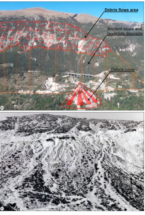
to observe a large debris flow area at the mid-slope,
above the inhabited village of Pescara del Tronto.
Sev-eral failures promote the idea that theflow probably
started by erosion along rills in the higher parts of the couloir and transformed into a mature debris flow in the subsequent transit area. Secondary failures of adjacent couloirs were also observed, which
enlarged the total extension of the debris flow area
(Figure 2a).
Slides and complex landslides are present both on the right (mainly in active state) and the left valley side (inactive state) of the Tronto River and are characterized by depths that generally are around the order of meters up to ten meters, occurring as a result of the dipping attitude of the arenaceous deposits. Landslide bodies generally consist of a chaotic mass of sandstone blocks involved in an abundant sandy-silty matrix. The sliding landslide, activated from the
left valley side of the Tronto River and probably responsible for the formation of the natural dam of the river, must also be placed at these phenomena. Its detachment area, located on the mid-toe slope between Pescara del Tronto and Tufo, is currently obliterated by recent and/or actual slope deposits; while, its landslide body, outcropping just down-stream and consisting of marly-calcareous rocks and limited levels of arenaceous deposits, forms part of the Holocene plain of the river and partly on the oppo-site slope (Aringoli et al., 2010;Gentili, 2001) starting from the river bed (660 m a.s.l.) up to 850–900 m a.s.l.
Debris flows phenomena, mainly represented by
channels and couloirs with debris discharge, are mainly present on the mid-slope of Mt. Macchialta, upward of Pescara del Tronto area (Figure 2a). These are extremely rapid processes, generated by the saturation of the detrital masses by water, with deposits characterized by the absence of stratification and extremely variable sediment texture (from clays to pebbles, to blocks). The state of activity of these processes is probably referable to the recent Holocene up to the beginning of the twentieth century (Farabol-lini et al., 2018, 2019;Farabollini & Spurio, 2009; Gen-tili, 2001; ISPRA, 2017a, 2017b), although probably they expressed their activity already in the upper Pleis-tocene (Coltorti & Farabollini, 1995; Dramis et al., 1980).
The southeastern slope of Mt. Macchialta is charac-terized by the presence of ancient slope and landslide deposits in correspondence of Pescara del Tronto and recent and active scree slope and landslide accumu-lation near Vezzano area. Moreover, a large debris cone affects the strongly damaged urban area of Pes-cara del Tronto. Local processes related to viscous deformation of shallow material (creep and/or solifluction) affect the steeper slopes or portions of slopes, where the eluvial-colluvial cover is thicker, and the action of running waters is greater, especially in correspondence of down-cutting streams and gullies.
Other landforms are linked to processes related to superficial running waters and, subordinately, to peri-glacial processes, recognizable only at higher altitudes (1400–1600 m a.s.l.) in the westernmost sector of the area and represented by nivation hollows.
The fluvial landforms are characterized by fluvial
erosion scarps at different height from the Tronto River plain, minor channels with deepening tendency (V-shaped valleys, gully erosion), and by some deposi-tional landforms, as the alluvial fans located near Vez-zano and Tufo areas. Landforms due to the running waters play a key role in modeling the landscape of the study area. These landforms are found on the entire hydrographic network, even if with different intensities in relation to the lithological features, slope gradients, and anthropic conditioning. Concave
valleys are widespread in the mid- and upper-slope and deeply incised in calcareous and marly-calcareous deposits, with general symmetrical shapes; while, gul-lies and V-shaped valleys are mostly present in mid-slope on the left valley side and the right valley side, incised in arenaceous and arenaceous-pelitic deposits. Widespread surface runoff processes are also present with rather fragmented and heterogeneous area exten-sion and distribution.
Finally, the geomorphological setting of the south-eastern slope of Mt. Macchialta is linked to the inter-action between the bedding attitude, the presence of surface runoff processes, both diffuse and concen-trated, and the development of slope processes and landforms due to slope gravity areal denudation. In
particular, according to available historical data, fol-lowing particularly heavy rainfall events, intense ero-sive processes were produced giving rise, in addition
to associated with debrisflows phenomena especially
in the area upstream of Pescara del Tronto, to signifi-cant mass movements and landslides so as to oblige the Bonifica del Tronto Consortium to repeatedly pro-tect the slope, in the years 1960–1972, with hydraulic-forestry works involving planting and reforestation (Figure 2b).
Geomorphological and available literature data were synthesized in a cross-section (lower right por-tion of the map), chosen in order to depict the
geome-try of the bedrock and landslide bodies. The profile
clearly describes how the geomorphological setting
Figure 2.(a) Panoramic view of Pescara del Tronto area. Note the large debrisflow area above the inhabited village. A debris cone, affecting the strongly damaged urban area, starts at the toe-slope involving ancient slope and landslide deposits; (b) Hydraulic-forestry works of the slope upstream of Pescara del Tronto made in the period 1960–1972 to mitigate the effects of repeated debrisflows and landslides.
of Pescara del Tronto area is linked to the dynamic
interaction between slope landforms and fluvial and
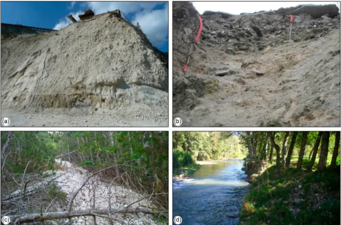
water landforms. The siliciclastic turbiditic bedrock, referable to the pre-evaporitic member of the Laga Formation is covered by Quaternary continental deposits (Figure 3). In detail, these deposits are in close connection with each other, with strong lateral and vertical facies variations, passing from ancient slope and landslide deposits, to recent debris deposits up to calcareous tufa deposits in‘cascade’ facies inter-digitated with deposits in‘riffle and pool’ facies (Far-abollini et al., 2004).
5. Discussions
The acquired data, verified and combined with
avail-able literature data (Chiessi et al., 2019; ISPRA,
2017a, 2017b), suggest a complex geomorphological
framework for the study area, which is largely affected
by debrisflow channels and couloirs with debris
dis-charge, confirming the zonation of landslide suscepti-bility, recognized in the framework of seismic microzonation (SM) activities and organized in di ffer-ent classes marking low, medium, high, and very-high landslide susceptibility (Amanti et al., 2018). The analysis of this numerous evidence, integrated with those found in neighboring areas of Sibillini Mts., has made it possible to estimate that approximately 70% of the effects found are attributable to fractures
and coseismic cracks; that about 8% are due to land-slides s.l. and deformations, while about 20% to fail-ure of road and network infrastructfail-ures and the remaining 2% to failure, variations in the water regime and other minor causes (Civico et al., 2018; Farabollini et al., 2018;Villani et al., 2019). It should be noted that the long seismic sequence that gave earthquakes greater than 5 Mw from August 2016 until January 2017 often amplified and overlapped effects already produced with the first shock of 24 August 2016 (Farabollini et al., 2018). This work allowed us to give a significant contribution to the knowledge of the geomorphological agents that affect the study area, highlighting the geological-geomorphological risk on the natural environment and the strongly damaged urban area. In fact, the total collapse of the built-up area of Pescara del Tronto, compared to the strong damage verified in the neighboring village, is due to the high heterogen-eity of the Quaternary continental deposits, mainly represented by ancient slope and landslide deposits, recent debris deposits, and calcareous tufa deposits. The wide area of distribution of the coseismic effects and their widespread variability and frequency made it possible to understand how the causes of the high heterogeneity of the effects on the physical environment and of the strong diversity, with the same structural characteristics of the buildings, of the damage is attributable to a very articulated
Figure 3.Quaternary continental deposits outcropping near Pescara del Tronto. (a) Ancient slope and landslide deposits; (b) Cal-careous tufa deposits in correspondence of the damaged urban area; (c) Recent debris deposits; (d) Fluvial and alluvial deposits in the Tronto River plain.
geomorphological context, also given by buried
mor-phologies that sometimes fall only outside the field
analysis and can be solved through the acquisition
of data deriving from detailed field surveys and
analysis (Amanti et al., 2018; Farabollini et al., 2019; Vignola et al., 2019).
6. Conclusions
The Pescara del Tronto area was investigated through a combination of geological and geomorphological field surveys, supported by air-photo interpretation and GIS analysis. The geological and geomorphologi-cal settings of the area are being discussed, depicting an area strongly struck by the 2016–2017 seismic sequence of Central Apennines. Following the main earthquakes of the sequence, the extent of damage was immediately registered and observed in several villages, with evidence of severity both in terms of fatalities and building collapses, as well as in terms of surface effects (i.e. debris flows and landslide). The integrated approach allowed us to produce a detailed geomorphological map (1:7,500 scale), as an
effective tool for representing and mapping the
evi-dence of debrisflows and landslides recognized in Pes-cara del Tronto area. The presented map provides important information for the implementation of land planning and loss-reduction measures and gives a contribution to the determination of situations that could lead to hazards following an earthquake, with particular attention to the role played by debris flows, landslides or deep-seated gravitational defor-mations. Finally, it could provide a scientific and methodological basis to demonstrate that accurate mapping provides important information, readily available for local administrations and decision-makers, for the implementation of sustainable land planning, emergency planning and the design of buildings or structures.
Software
The vector/raster data and main map were managed
using QGIS 3.10‘A Coruna’®, with final editing
per-formed using Corel Draw 2019®.
Acknowledgment
The authors wish to thank the Posizione di Funzione Urba-nistica, paesaggio ed informazioni territoriali of Marche Region for providing topographic, geological, and geomor-phological data ( https://www.regione.marche.it/Regione-Utile/Paesaggio-Territorio-Urbanistica/Cartografia). Urban areas are provided by ISTAT (https://www.istat.it/it/ archivio/104317). Finally, the authors are grateful to the reviewers Mike Shand, Sziárd Szabó, and Giandomenico Fubelli for their critical comments and suggestions that greatly improved the manuscript and map.
Disclosure statement
No potential conflict of interest was reported by the author(s).
Funding
The work was supported by Università degli Studi di Camerino funds (P. Farabollini University funds).
ORCID
Piero Farabollini http://orcid.org/0000-0003-2414-2938
Marco Emanuele Discenza http://orcid.org/0000-0001-8534-9989
Cristiano Carabella http://orcid.org/0000-0001-9206-2812
Giorgio Paglia http://orcid.org/0000-0003-4281-4988
Enrico Miccadei http://orcid.org/0000-0003-2114-2940
References
Aleotti, P., & Chowdhury, R. (1999). Landslide hazard assessment: Summary review and new perspectives. Bulletin of Engineering Geology and the Environment, 58 (1), 21–44.https://doi.org/10.1007/s100640050066
Amanti, M., Calcaterra, S., Chiessi, V., D’Orefice, M., Ferri, F., Fiorenza, D., Porfidia, B., Puzzilli, L. M., Roma, M., & Troccoli, A. (2017, November 4–16). Lo studio di micro-zonazione sismica della frazione di pescara del Tronto (AP). In Atti del 36° Convegno Nazionale GNGTS– ses-sione 2.2, Trieste.
Amanti, M., Federico, A., Berti, D., Blumetti, A., Bonomo, R., Brustia, E.,… Vittori, E. (2018). Le attività del Servizio Geologico d’Italia (ISPRA) a seguito della sequenza sismica del 2016-2017 in Italia Centrale. Geologia dell’Ambiente - Italian Magazine of Environmental Geology, XXVI, 117–135.
Aringoli, D., Bufalini, M., Farabollini, P., Giacopetti, M., Materazzi, M., Pambianchi, G., & Scalella, G. (2018). Effetti geomorfologici e variazioni idrogeologiche indotti dai terremoti: esempi nell’area epicentrale della sequenza sismica 2016-2017 del centro Italia. Geologia dell’Ambiente, 1/2018 (ISSN 1591-5352), 239–248. Aringoli, D., Farabollini, P., Gentili, B., Materazzi, M., &
Pambianchi, G. (2007). Climatic influence on slope dynamics and shoreline variations: Examples from Marche region (Central Italy). Physio-Géo, 1, 1–20.
https://doi.org/10.4000/physio-geo.1035
Aringoli, D., Farabollini, P., Giacopetti, M., Materazzi, M., Paggi, S., Pambianchi, G., Pierantoni, P. P., Pistolesi, E., Pitts, A., & Tondi, E. (2016). The August 24th 2016 accu-moli earthquake: Surface faulting and deep-seated gravi-tational slope deformation (DSGSD) in the Monte Vettore area. Annals of Geophysics, 59(5), https://doi. org/10.4401/ag-7199
Aringoli, D., Gentili, B., Materazzi, M., & Pambianchi, G. (2010). Mass movements in adriatic central Italy: Activation and evolutive control factors. In Ernest D. Werner et al. (Eds.), Landslides: Causes, types and effects (pp. 1–72). New York, NY: Nova Science Publishers, Inc. Ausilio, E., Silvestri, F., Tropeano, G., & Zimmaro, P. (2018). Landslides triggered by recent earthquakes in Italy. Technical Report, Joint Technical Committee JTC1 – TR4: Natural Slopes and Landslides – Earthquake-JOURNAL OF MAPS 7
Induced Landslides, Federation of the International Geoengineering Societies (FedIGS).
Bocco, G., Mendoza, M., & Velázquez, A. (2001). Remote sensing and GIS-based regional geomorphological map-ping: A tool for land use planning in developing countries. Geomorphology, 39(3–4), 211–219. https:// doi.org/10.1016/S0169-555X(01)00027-7
Bozzano, F., Carabella, C., De Pari, P., Discenza, M. E., Fantucci, R., Mazzanti, P., Miccadei, E., Rocca, A., Romano, S., & Sciarra, N. (2020). Geological and geomor-phological analysis of a complex landslides system: The case of San Martino sulla Marruccina (Abruzzo, Central Italy). Journal of Maps, 16(2), 126–136. https://doi.org/ 10.1080/17445647.2019.1702596
Calamita, F., & Pizzi, A. (1994). Recent and active exten-sional tectonics in the southern umbro-marchean Apennines (Central Italy). Memorie Della Società Geologica Italiana, 48, 541–548.
Calista, M., Miccadei, E., Pasculli, A., Piacentini, T., Sciarra, M., & Sciarra, N. (2016). Geomorphological features of the Montebello sul Sangro large landslide (Abruzzo, Central Italy). Journal of Maps, 12(5), 882–891.https:// doi.org/10.1080/17445647.2015.1095134
Calista, M., Miccadei, E., Piacentini, T., & Sciarra, N. (2019). Morphostructural, meteorological and seismic factors controlling landslides in weak rocks: The case studies of Castelnuovo and Ponzano (north east Abruzzo, central Italy). Geosciences, 9(3), 122. https://doi.org/10.3390/ geosciences9030122
Carabella, C., Miccadei, E., Paglia, G., & Sciarra, N. (2019). Post-wildfire landslide hazard assessment: The case of the 2017 montagna del morrone fire (central Apennines, Italy). Geosciences, 9(4), 175. https://doi.org/10.3390/ geosciences9040175
Cello, G., Mazzoli, S., Tondi, E., & Turco, E. (1997). Active tectonics in the central Apennines and possible impli-cations for seismic hazard analysis in peninsular Italy. Tectonophysics, 272(1), 43–68. https://doi.org/10.1016/ S0040-1951(96)00275-2
Centamore, E., & Deiana, G. (1986). La geologia delle Marche. Studi Geologici Camerti, vol. spec., 156pp. Chelli, A., Segadelli, S., Vescovi, P., & Tellini, C. (2016).
Large-scale geomorphological mapping as a tool to detect structural features: The case of Mt. Prinzera ophiolite rock mass (Northern Apennines, Italy). Journal of Maps, 12(5), 770–776.https://doi.org/10.1080/17445647. 2015.1072115
Chiaraluce, L., Di Stefano, R., Tinti, E., Scognamiglio, L., Michele, M., Casarotti, E., Cattaneo, M., De Gori, P., Chiarabba, C., Monachesi, G., Lombardi, A., Valoroso, L., Latorre, D., & Marzorati, S. (2017). The 2016 central Italy seismic sequence: Afirst look at the mainshocks, after-shocks, and source models. Seismological Research Letters, 88(3), 757–771.https://doi.org/10.1785/0220160221
Chiessi, V., Amanti, M., Roma, M., Puzzilli, L. M., Ferri, F., & Barnaba, C. (2019). Multidisciplinary approach for the seismic microzonation of pescara del tronto (Ap-central italy). Earthquake Geotechnical Engineering for Protection and Development of Environment and Constructions- Proceedings of the 7th International Conference on Earthquake Geotechnical Engineering (pp. 1762–1767).
Civico, R., Pucci, S., Villani, F., Pizzimenti, L., De Martini, P. M., & Nappi, R. (2018). Surface ruptures following the 30 October 2016 Mw 6.5 Norcia earthquake, central Italy. Journal of Maps, 14(2), 151–160. https://doi.org/10. 1080/17445647.2018.1441756
Coltorti, M., & Dramis, F. (1990). Geologia e geomorfologia. In Parco dei Sibillini (pp. 132–137). Tecnoprint, Ancona. Coltorti, M., & Farabollini, P. (1995). Quaternary evolution of the“Castelluccio di Norcia” basin (Umbro-Marchean Apennines, central Italy). Il Quaternario, 8(1), 149–166. Dramis, F., Coltorti, M., & Gentili, B. (1980). Glacial and
periglacial morphogenesis in the Umbria-Marche Apennines. Abstracts 24th International Geographical Congress, Tokyo (Vol. 1, pp. 114–115).
Dramis, F., Farabollini, P., Gentili, B., & Pambianchi, G. (2001, September 21–27). Neotectonics and large-scale gravitational phenomena in the Umbria–Marche Apennines, Italy. In Seismically Induced Ground Ruptures and Large-Scale Mass Movements. Field Excursion and Meeting. APAT, Atti, 4/2002, Rome, 17–30. Dramis, F., Guida, D., & Cestari, A. (2011). Nature and aims of geomorphological mapping. In Developments in earth surface processes (Vol. 15, pp. 39–73).https://doi.org/10. 1016/B978-0-444-53446-0.00003-3
Dykes, A. P. (2008). Geomorphological maps of irish peat landslides created using hand-held GPS. Journal of Maps, 4(1), 258–276. https://doi.org/10.4113/jom.2008. 1029
Emergeo, W. G., Pucci, S., De Martini, P. M., Civico, R., Nappi, R., Ricci, T., Villani, F., Brunori, C. A., Caciagli, M., Sapia, V., & Lancia, M. (2016). Coseismic effects of
the 2016 Amatrice seismic sequence: First geological results. Annals of Geophysics. https://doi.org/10.4401/ag-7195
Farabollini, P., Angelini, S., Fazzini, M., Lugeri, F.R., Scalella, G., & GeomorphoLab (2019). Earthquakes and Society: the 2016 Central Italy Reverse Seismic Sequence. In: Farabollini, Lugeri, Mugnano (Eds.), Earthquake risk per-ception, communication and mitigation strategies across Europe, Geographies of the Anthropocene, Il Sileno Edizioni (ISSN 2611-3171), 249-266.
Farabollini, P., Fazzini, M., Fuffa, E., Giacopetti, M., Lugeri, F. R., Materazzi, M., Pambianchi, G., & Marche, G. S. R. (2018). La sequenza sismica dell’Italia centrale del 24 agosto e successive: Contributi alla conoscenza e la banca dati degli effetti di superficie. Rendiconti Online Della Società Geologica Italiana, 46, 9–15. https://doi. org/10.3301/ROL.2018.45
Farabollini, P., Folchi Vici d’Arcevia, C., Gentili, B., Luzi, L., Pambianchi, G., & Viglione, F. (1995). La morfogenesi gravitativa nelle formazioni litoidi dell’Appennino cen-trale. Memorie della Società Geologica Italiana, 50, 123– 136.
Farabollini, P., Materazzi, M., Miccadei, E., & Piacentini, T. (2004). I travertini dell’ Italia centrale adriatica: Genesi, cronologia, significato geomorfologico e paleoambien-tale. Il Quaternario, 17(2/1), 259–272.
Farabollini, P., & Spurio, E. (2009). Applicazione dei GIS nello studio dei fenomeni di debrisflows dell’Appennino umbro-marchigiano (Regione Marche, Italia). Rendiconti Online Societa Geologica Italiana, 8, 50–58.
Gentili, B. (2001). Note di geomorfologia del Parco Nazionale dei Monti Sibillini. Aniballi Grafiche, Ancona, 50pp.
Gentili, B., Pambianchi, G., Aringoli, D., Materazzi, M., & Giacopetti, M. (2017). Pliocene-Pleistocene geomorpho-logical evolution of the Adriatic side of Central Italy. Geologica Carpathica, 68(1), 6–18. https://doi.org/10. 1515/geoca-2017-0001
Glade, T., Anderson, M., & Crozier, M. J. (2012). Landslide hazard and risk. Landslide Hazard and Risk.https://doi. org/10.1002/9780470012659
Gustavsson, M., Kolstrup, E., & Seijmonsbergen, A. C. (2006). A new symbol-and-GIS based detailed geomor-phological mapping system: Renewal of a scientific disci-pline for understanding landscape development. Geomorphology, 77(1–2), 90–111. https://doi.org/10. 1016/j.geomorph.2006.01.026
ISIDe Working Group. (2016). Italian seismological instru-mental and parametric database – version 1.0. Istituto Nazionale di Geofisica e Vulcanologia (INGV).https:// doi.org/10.13127/ISIDE
ISPRA. (2007). Guida alla rappresentazione cartografica della Carta Geomorfologica d’Italia in scala 1:50,000. Quaderni Serie III Del Servizio Geologico Nazionale. ISPRA. (2017a). Sintesi delle conoscenze sull’evoluzione del
pendio sottostante l’abitato di Pescara del Tronto, a seguito della sequenza sismica manifestatasi a partire dal 24 agosto 2016. Prot. ISPRA 6432/2017 del 10/02/ 2017– Rapporto inedito (in italian).
ISPRA. (2017b). Valutazione della suscettibilità a fenomeni di instabilità geologici nell’area di Pescara del Tronto (Comune di Arquata del Tronto - AP). Prot. ISPRA 27229/2017 del 01/06/2017 – Rapporto inedito (in italian).
ISPRA & AIGEO. (2018). Aggiornamento ed integrazione delle linee guida della Carta Geomorfologica d’Italia in scala 1:50,000. Quaderni Serie III Del Servizio Geologico Nazionale.
Keefer, D. K. (2002). Investigating landslides caused by earthquakes – A historical review. Surveys in Geophysics, 23(6), 473–510. https://doi.org/10.1023/ A:1021274710840
Konovalov, A., Gensiorovskiy, Y., Lobkina, V., Muzychenko, A., Stepnova, Y., Muzychenko, L., Stepnov, A., & Mikhalyov, M. (2019). Earthquake-induced landslide risk assessment: An example from Sakhalin Island, Russia. Geosciences, 9(7), 305. https:// doi.org/10.3390/geosciences9070305
Laurenzano, G., Barnaba, C., Romano, M. A., Priolo, E., Bertoni, M., Bragato, P. L., Comelli, P., Dreossi, I., & Garbin, M. (2019). The Central Italy 2016–2017 seismic sequence: Site response analysis based on seismological data in the Arquata del Tronto–Montegallo municipali-ties. Bulletin of Earthquake Engineering, 17(10), 5449– 5469.https://doi.org/10.1007/s10518-018-0355-3
Lee, E. M. (2001). Geomorphological mapping. Geological Society, London, Engineering Geology Special Publications, 18(1), 53–56. https://doi.org/10.1144/gsl. eng.2001.018.01.08
Lin, C. W., Shieh, C. L., Yuan, B. D., Shieh, Y. C., Liu, S. H., & Lee, S. Y. (2004). Impact of Chi-Chi earthquake on the occurrence of landslides and debrisflows: Example from the Chenyulan River watershed, Nantou, Taiwan. Engineering Geology, 71(1–2), 49–61.https://doi.org/10. 1016/S0013-7952(03)00125-X
Liu, C., Zheng, Y., Xie, Z., & Xiong, X. (2017). Rupture fea-tures of the 2016 Mw 6.2 norcia earthquake and its poss-ible relationship with strong seismic hazards. Geophysical Research Letters, 44(3), 1320–1328. https://doi.org/10. 1002/2016GL071958
Livio, F., & Ferrario, M. F. (2020). Assessment of attenu-ation regressions for earthquake-triggered landslides in the Italian Apennines: Insights from recent and historical events. Landslides. https://doi.org/10.1007/s10346-020-01464-w
Marsala, V., Galli, A., Paglia, G., & Miccadei, E. (2019). Landslide susceptibility assessment of Mauritius Island
(Indian ocean). Geosciences, 9(12), 493. https://doi.org/ 10.3390/geosciences9120493
Martino, S., Antonielli, B., Bozzano, F., Caprari, P., Discenza, M. E., Esposito, C., Fiorucci, M., Iannucci, R., Marmoni, G. M., & Schilirò, L. (2020). Landslides trig-gered after the 16 August 2018 Mw 5.1 Molise earthquake (Italy) by a combination of intense rainfalls and seismic shaking. Landslides, 17(5), 1177–1190. https://doi.org/ 10.1007/s10346-020-01359-w
Martino, S., Battaglia, S., D’Alessandro, F., Della Seta, M., Esposito, C., Martini, G., Pallone, F., & Troiani, F. (2019). Earthquake-induced landslide scenarios for seis-mic seis-microzonation: Application to the Accumoli area (Rieti, Italy). Bulletin of Earthquake Engineering, 18(12), 5655–5673.https://doi.org/10.1007/s10518-019-00589-1
Martino, S., Prestininzi, A., & Romeo, R. W. (2014). Earthquake-induced ground failures in Italy from a reviewed database. Natural Hazards and Earth System Sciences, 14(4), 799–814. https://doi.org/10.5194/nhess-14-799-2014
Masi, A., Santarsiero, G., Chiauzzi, L., Gallipoli, M. R., Piscitelli, S., Vignola, L., Bellanova, J., Calamita, G., Perrone, A., Lizza, C., & Grimaz, S. (2016). Different damage observed in the villages of Pescara del Tronto and Vezzano after the M6.0 August 24, 2016 central Italy earthquake and site effects analysis. Annals of Geophysics, 59(5), 1–12.https://doi.org/10.4401/AG-7271
Materazzi, M., Gentili, B., Aringoli, D., Farabollini, P., & Pambianchi, G. (2010). Elements of slope and fluvial dynamics as evidence of late holocene climatic fluctu-ations in the central adriatic sector, Italy. Geografia Fisica e Dinamica Quaternaria, 33, 193–204.
Miccadei, E., Piacentini, T., Gerbasi, F., & Daverio, F. (2012). Morphotectonic map of the Osento River basin (Abruzzo, Italy), scale 1:30,000. Journal of Maps, 8(1), 62–73.https://doi.org/10.1080/17445647.2012.668764
Nowicki Jessee, M. A., Hamburger, M. W., Ferrara, M. R., McLean, A., & FitzGerald, C. (2020). A global dataset and model of earthquake-induced landslide fatalities. Landslides, 17(6), 1363–1376. https://doi.org/10.1007/ s10346-020-01356-z
Otto, J.-C., & Smith, M. J. (2013). Geomorphological map-ping. In L. Clarke (Eds.) Geomorphological Techniques (2)1–10. British Society for Geomorphology, ISSN 2047-0371.
Peruccacci, S., Brunetti, M. T., Gariano, S. L., Melillo, M., Rossi, M., & Guzzetti, F. (2017). Rainfall thresholds for possible landslide occurrence in Italy. Geomorphology, 290, 39–57.
https://doi.org/10.1016/j.geomorph.2017.03.031
Pierantoni, P., Deiana, G., & Galdenzi, S. (2013). Stratigraphic and structural features of the sibillini moun-tains (Umbria- Marche Apennines, Italy). Italian Journal of Geosciences, 132(3), 497–520.https://doi.org/10.3301/ IJG.2013.08
Pizzi, A., Di Domenica, A., Gallovič, F., Luzi, L., & Puglia, R. (2017). Fault segmentation as constraint to the occur-rence of the main shocks of the 2016 Central Italy seismic sequence. Tectonics, 36(11), 2370–2387.https://doi.org/ 10.1002/2017TC004652
Quesada-Román, A., Fallas-López, B., Hernández-Espinoza, K., Stoffel, M., & Ballesteros-Cánovas, J. A. (2019). Relationships between earthquakes, hurricanes, and land-slides in Costa Rica. Landland-slides, 16(8), 1539–1550.https:// doi.org/10.1007/s10346-019-01209-4
Regione Marche. (2014). Microzonazione sismica del Comune di Arquata del Tronto. Attuazione art. 11 JOURNAL OF MAPS 9
legge n.77/2009. OCDPC n. 52/2013. Dipatimento Protezione Civile regione Marche, Regione Marche. Seijmonsbergen, A. C. (2013). The modern
geomorpho-logical map. In Treatise on geomorphology (pp. 35–52). https://doi.org/10.1016/B978-0-12-374739-6. 00371-7
Smith, M. J., Paron, P., & Griffiths, J. S. (Eds.). (2011). Geomorphological mapping: Methods and applications. Developments in Earth Surface Processes (Vol. 15, p. 610). Elsevier, Amsterdam.
Tanyaş, H., van Westen, C. J., Allstadt, K. E., Anna Nowicki Jessee, M., Görüm, T., Jibson, R. W., Godt, J. W., Sato, H. P., Schmitt, R. G., Marc, O., & Hovius, N. (2017). Presentation and analysis of a worldwide database of earthquake-induced landslide inventories. Journal of Geophysical Research: Earth Surface, 122(10), 1991– 2015.https://doi.org/10.1002/2017JF004236
Tavernelli, E., Butler, R. W. H., Decandia, F. A., Calamita, F., Grasso, M., Alvarez, W., & Renda, P. (2004). Implications of fault reactivation and structural inheritance in the Cenozoic evolution of Italy. Special Volume of the Italian Geological Society for the IGC 32 Florence, 209–222.
Tondi, E., & Cello, G. (2003). Spatiotemporal evolution of the Central Apennines fault system (Italy). Journal of
Geodynamics, 36(1–2), 113–128.https://doi.org/10.1016/ S0264-3707(03)00043-7
Turner, A. K. (2018). Social and environmental impacts of landslides. Innovative Infrastructure Solutions, 3(70).
https://doi.org/10.1007/s41062-018-0175-y
Vaz, T., & Zêzere, J. L. (2016). Landslides and other geomor-phologic and hydrologic effects induced by earthquakes in Portugal. Natural Hazards, 81(1), 71–98.https://doi. org/10.1007/s11069-015-2071-5
Vignola, L., Gallipoli, M. R., Chiauzzi, L., Stabile, T. A., Piscitelli, S., Santarsiero, G., Bellanova, J., Calamita, G., & Perrone, A. (2019). Geophysical and engineering analy-sis of different earthquake damage in Pescara del Tronto and Vezzano (Arquata del Tronto municipality) follow-ing the 24th August 2016 central Italy earthquake. Bulletin of Earthquake Engineering, 17(10), 5471–5493.
https://doi.org/10.1007/s10518-018-0450-5
Villani, F., Sapia, V., Baccheschi, P., Civico, R., Di Giulio, G., Vassallo, M., Marchetti, M., & Pantosti, D. (2019). Geometry and structure of a fault-bounded extensional basin by integrating geophysical surveys and seismic ani-sotropy across the 30 October 2016 M w 6.5 earthquake fault (Central Italy): The Pian Grande di Castelluccio Basin. Tectonics, 38(1), 26–48. https://doi.org/10.1029/ 2018TC005205