UNIVERSITÀ DEGLI STUDI DI ROMA “ROMA TRE”
Dipartimento di Scienze Geologiche
SCUOLA DOTTORALE IN
GEOLOGIA DELL’AMBIENTE E DELLE RISORSE
(SDIGAR)
XXII CICLO
Coordinatore Prof. Domenico Cosentino
SEZIONE GEOLOGIA DELL’AMBIENTE E GEODINAMICAACTIVE DEFORMATION AND VOLCANISM OFFSHORE CAMPI
FLEGREI: NEW DATA FROM SEISMIC REFLECTION PROFILES.
Tutore:
Prof.
Claudio Faccenna
Co-tutore
Dr.
Pier Paolo Bruno
Candidato
Michele Punzo
I
Page
1. Introduction
1
CHAPTER 1
1.1. Regional and local geological setting
7
1.2
Ischia
Island
16
CHAPTER 2
Seismic Stratigraphy Scheme
2.1
Methodology
19
2.2
Seismo-stratigraphic
features
19
2.2.1
Log
data
analysis 21
2.2.2
Seismic
data
analysis
23
CHAPTER 3
Interpretation of seismic reflection profiles offshore Campi Flegrei
3.1
Introduction
32
3.2
Interpretation
of
the
seismic
lines
34
3.3
Discussion
51
3.3.1 Evolution of the Bay
of
Naples 51
3.3.2
The
uplift
of
Ischia
54
3.3.3
Data
analysis
60
CHAPTER 4
Reprocessing and interpretation of seismic lines onshore Campi
Flegrei
4.1
Introduction
71
4.2
Interpretation
of
the
seismic
lines
75
4.3 Discussion and conclusion of tomographic
sections
81
CHAPTER
5
High resolution investigations offshore Pozzuoli Bay
II
5.2
Seismic
equipment
and
data
recording
87
5.3
Data
processing
90
5.4 Interpretation of the GeoB seismic profiles in Pozzuoli Bay
91
GeoB seismic profiles in Pozzuoli Bay
5.4.1
Profile
GeoB08-065
92
5.4.2
Profiles
GeoB08-108
95
5.5
Discussion
98
5.6
Geologic
evolution
of
Pozzuoli
Bay
102
6.
Conclusions
105
1
1. Introduction
In south-western Italy, the Bay of Naples encompasses two volcanic regions which were highly active for the past 400 kyrs. The large stratovolcano Monte Somma-Vesuivius dominates the area to the east of the bay whereas the Campi Flegrei (‘Burning Fields’) shape the north-western part of Naples Bay.
Both volcanic provinces are characterised by numerous eruptions in the more recent geologic past. In the Northwest, two severe eruptions at 39 and 15 ka B.P. within Campi Flegrei lead to caldera collapses, the formation of Pozzuoli Bay and thick deposits of tuff and other volcanoclastic all over the northern part of Naples Bay. Within the last 15 kyrs, numerous small scale eruption centres scattered all over Campi Flegrei and within Pozzuoli Bay. Strong subsidence and a pronounced sea level rise since the Last Glacial Maximum lead to an intercalation of the volcanic deposits with marine sediments. Towards the East of Naples Bay, the substratum offshore Herculaneum is made of an alternating succession of pyroclastic density currents and marine sediments mainly originating from three to four large plinian (i.e. highly explosive) eruptions of Vesuvius within the last 18 kyrs. Large collapse calderas represent an exceptional explosive type of volcanism, not only dangerous to local population but with potential global impact. One of these structures can be found at the west coast of Italy near the city of Naples, within the 200 km2 Campi Flegrei area. Campi Flegrei is centered around the Bay of Pozzuoli and not only covers a large area of the shelf, it also includes outskirts of Naples and is overall inhabited by more than 1.5 million people.
Volcanic activity at Campi Flegrei ranges from 300 ka B.P. to 1538 A.D. with most severe eruptions from 60 ka B.P. onward (Rosi & Sbrana, 1987; Pappalardo et al., 1999). Today, the onshore part of Campi Flegrei is structurally dominated by a quasi circular caldera-like shape some 12 km in diameter, which includes about 30 small volcanic edifices such as tuff cones, cinder cones, maars and domes (Rosi & Sbrana,
Introduction
2
1987; Scarpati et al., 1993; Orsi et al., 1996; Di Vito et al., 1999; Deino et al., 1994, 2004; Piochi et al., 2004). These mostly effusively erupted magma volumes of less than 0.1 km³ dense rock equivalent (DRE) in monogenetic manner (Di Vito et al., 1987; Rosi & Sbrana, 1987; Di Vito et al., 1999; Mastrolorenzo, 1994; Lirer et al., 2001; Orsi et al., 2009). However, three severe explosive eruptions shaped the Campi Flegrei Volcanic District: the Monte Epomeo Green Tuff of Ischia Island at 55 ka B.P. and 45 km³ DRE (Vezzoli, 1988), the Campanian Ignimbrite at 39 ka B.P. and 150 km³ DRE (Civetta et al., 1997; De Vivo et al., 2001; Orsi et al., 1996; Rosi et al., 1996; Rosi and Sbrana, 1987; Fisher et al., 1993), the Neapolitan Yellow Tuff at 15 ka B.P. and 40 km³ DRE (De Vivo et al., 2001; Deino et al., 2004). The last two events are believed to have caused large caldera collapses, vast pyroclastic deposits over the Campanian Plain and in the offshore area of the Bay of Naples. The Yellow Tuff products nowadays still dominates the landscape around Pozzuoli Bay.
Seismic reflection represents one of the geophysical techniques that better allow the reconstruction of the subsurface geologic structures. Such technique in the last few years, has achieved a remarkable improvement, in the wake of oil search, both for the technological development of the equipment in the acquisition phase, and for the progress of computers that have allowed the application of more complicated techniques.
In this thesis, from these considerations, I will discuss of four main subjects:
1) Interpretation of seismic reflection profiles offshore Campi Flegrei (CF) area permitted the identification of several geologic features in the inner shelf offshore Campi Flegrei and Bay of Naples. The seismic dataset used for my work was collected by OGS (Osservatorio Geofisico Sperimentale – Trieste) during 1973 and recently reprocessed by Bruno et al., 2002 and 2003. The overall quality of seismic data is high, although the data suffer of technological limits of 35 years ago. A reprocessing of the data (Bruno et al., 2000, 2002, 2003) reduced most
3
of the limiting effects of the acquisition phase. The more recent seismic data collected in this area are, in most cases, high resolution − single channel sparker and uniboom profiles, which allow the shallow Quaternary cover to be studied in detail (Fusi et al., 1991; Milia, 1996, 1998, 2000; Milia et al., 1998; Aiello, 2005), but do not penetrate deep; therefore, very little can be said about the deeper morphostructural features of the area, especially in CF area. For that reason, full fault geometry and kinematics, and in some cases the tectonic involvement of the deep geological units are hypothetical. For all these reasons the sea environment geology in the Ischia area and in the Gulf of Naples is less known than the onshore areas. Reprocessing (Bruno et al., 2000) permitted to gain more information on the deep part of Bay of Naples and CF, and to obtain new information at low cost.
The interpretation of seismic profiles allowed the identification of four seismo-stratigraphic units. However, I was interested mainly to structural analysis, also because a detailed seismic stratigraphy is beyond the resolution of the data.
The main goal was, in fact, to build the stratigraphic framework through the identification of depositional units and to delineate a broad geo-volcanological and structural framework of the CF with the aim of exploring the connection between volcanism and tectonics. Individual units were delineated on the basis of contact relation and internal layering characteristics as revealed by seismic reflectivity. Seismic facies analysis permits, in fact, to delineate the environmental setting of the studied area. The identification on seismic section of important faults allows to perform a structural analysis of the investigated area. The fault pattern was obtained by spatial interpolation of fault traces along single profiles. The study stresses also on the recognition of the fault systems responsible for the formation of Ischia Island and the Bay of Naples and finding their relationship with the sedimentary and volcanic units of the area.
2) Reprocessing and interpretation of seismic lines 306-78 and Na-307-78 (ENI-AGIP) localized at the passage from northern zone of the
Introduction
4
Campi Flegrei to the southern sector of Volturno Plain. A reprocessing of this seismic lines permitted to increment signal/noise ratio and to improve vertical and horizontal resolution. The aim was to improve the data quality from the elaboration of 1978. In parallel with the processing of the seismic data, Licola1 well log has been digitalized and processed. Sonic log (Bhc), radioactive log (Gamma-ray) and electrical log (Dual laterolog) were elaborated. Objectives of this study has been to gain geologic ties on which founding the interpretation of the seismic lines. 3) Interpretation of first arrivals by means of seismic tomography of all Eni-Agip seismic lines belonging to the Naples permit. Seismic reflection data processing benefit of tomographic inversion of first arrivals to improve the performance of the static corrections and the imaging of the shallow structure (0-300 m deep). The shallow seismic imaging is very poor due to the superficial geology (volcanic sequences), strong lateral Vp changes, acquisition gaps and to an overall low CMP folding. Consequently, the shallow-intermediate structures are poorly imaged. Seismic tomography is used to extend the seismic imaging not sampled by the deep multichannel seismics.
This deep seismic dataset available permitted the reconstruction of the structure and the morphology of the submerged carbonate basement and to describe the characteristics of the fault systems responsible for the formation of Ischia and Bay of Naples. The seismic interpretation moreover led important considerations about the mechanics of resurgence of Ischia Island, outlines the structural setting of the bay and the tectonic relationships between Campi Flegrei and the island of Ischia. The greater tectonic complexity of Campi Flegrei area with respect Vesuvius district is also shown. A general view of the seismic line permitted also the reconstruction of the Quaternary tectono-stratigraphic evolution of this sector of the Eastern peri-Tyrrhenian margin.
Despite this study done at this sector of CF, there is a considerable lag of knowledge about the stratigraphic-structural setting of the Pozzuoli Bay area. For example caldera-diagnostic evidence like buried volcanic
5
features (e.g. rim structure) and the reconstruction of the volcano/sedimentary evolution are not well defined or questionable.
4) In this thesis, I will discuss the processing and interpretation of high resolution multi-channel seismic profiles acquired during the oceanographic cruise CAFE_07 – Leg 3, conducted in Naples and Pozzuoli Bay in January 2008 by IAMC-CNR in collaboration with Bremen University. Within the scope of this thesis, the processing and the interpretation of these reflection seismic profiles allow to reconstruct the young depositional history in Campi Flegrei offshore area (Pozzuoli Bay). The re-processed old multichannel seismics (OGS, 1973), in fact, permit the reconstruction of fault geometry and kinetic and to gain new hints about the tectonic involvement of the deep units, but nevertheless these outcomes did not at all yield high-resolution images on meter-scale. In contrast, seismic dataset acquired in the recent past (Fusi et al., 1991; Milia, 1998; Milia et al., 1998, 2000) are sparker and boomer surveys which are highly limited in their vertical and horizontal resolution and severely suffer from analogue recording and very shallow penetration depth (absolute best would be 0.3 s TWT).
CAFE seismic lines close the gap between very shallow and the available deep seismic data.
The area of interest for this thesis is the north-western part of Naples Bay, particularly the Gulf of Pozzuoli. The multichannel reflection seismics shots during January 2008 in this region’s shallow waters (max. depth ~150 m) allow for high vertical and lateral resolution of volcanic features and the sedimentary interplay with an acceptable penetration depth. The digital recording of the survey allows for all modern processing steps to make use of the full potential of such unconventional data set. The already established stratigraphy for the last 15 kyrs from the submerged part of Campi Flegrei could be validated in the new seismic data, primarily by means of seismic reflector terminations. Moreover, the high vertical and lateral resolution in the range of one meter contributed to improve the resolution of the published acoustic data in terms of a more detailed classification of single seismic units.
Introduction
6
Nevertheless, the newly acquired seismic data allowed for a clear definition of the seismic facies parameters. On this basis, deposits of pyroclastic density currents could be well defined and thus distinguished from marine units.
7
CHAPTER 1
1.1 Regional and local geological setting
The Campi Flegrei Volcanic District (CFVD) is situated on the western continental margin of the Campanian Plain in a Pliocene-Quaternary extensional basin (fig. 2). The area is dominated by NE-SW and NW-SE trending normal faults and the Apennine thrust belt to the east (Oldow et al., 1993; Ferranti et al., 1996; Milia & Torrente, 1999).
For the past 30 to 35 Myrs, the Mediterranean tectonics were controlled by retreating subduction within the Africa–European convergence zone (Malinverno and Ryan, 1986; Royden, 1993; Wortel and Spakman, 2000; Faccenna et al., 2001; Jolivet et al., 2008). Because of this slab roll-back and accompanying back-arc extension, the Tyrrhenian Sea started opening by rifting between the Corsica–Sardinia block and the Italian peninsula during early Oligocene (Oldow et al., 1993) (fig. 1).
Fig. 1: Evolution of the peri-Tyrrhenian Sea and orogenic belt. 1: undeformed foreland deposits; 2: deformed foredeep deposits; Allochtones of: 3: N-Appenines, 4: Abruzzi, 5: Campania-Lucania & S-Apennines, 6: W-Sicily; 7: undifferentiated basal units; 8: Calabrian arc & associated rocks in N-Africa; 9: Alpine Thrust Belt; 10: oceanic crust of late Miocene-Pliocene/ Pliocene-Pleistocene age; HANF: high angle normal faults; LANF: low angle normal faults. (Oldow et al., 1993)
Chapter 1 – Geological Setting
8
Generally large scale block rotations occurred in the Miocene and Pliocene, transport direction was towards the East and changed to NE for the Apennines segment during Pliocene (Oldow et al. 1993). The southern Tyrrhenian Sea is underlain by oceanic crust formed during the rifting with its formation centre shifting from the basins’ central part (late Miocene - early Pliocene) to south-eastern part (Pliocene - Pleistocene) (Oldow et al., 1993), fig. 1. As a consequence, the Tyrrhenian margin was affected by tensile tectonics, characterized by N– S and NNW–SSE normal
faults, and then by NW–SE and NE–SW normal faults and W–E strike-slip faults (Doglioni, 1991) (fig. 2). Moreover, a large horst and graben structure split into several smaller asymmetric horst-graben structures and hosting the Campanian Plain (which incorporates CF)
(Milia, 1999a; Milia&Torrente, 1999). The
graben basement is made of Mesozoic carbonates which crop out at the Sorrento peninsula, the southern limiting horst of Naples Bay (Finetti-Morelli, 1974, Milia, 1999). The half-grabens are
tilted to the NW and filled with Late Pliocene to Quaternary siliciclastic sediments (up to 3 - 5 km) and volcanoclastic material (Orsi et al., 1996 and references therein).
Beside the main NE-SW and NW-SE normal faults, minor E-W trending ones also occur in Naples Bay (Milia & Torrente, 1999). These faults
Fig. 2: The Neapolitan volcanic district is located on the Tyrrhenian margin of the Campanian Plain. This plain is a NW-SE Plio-Quaternary basin filled up by more than 3000 m of Quaternary clastics and volcanic rocks overlying a Mesozoic carbonate substratum. During the Late Quaternary, because of intense volcanic activity, thick volcanic units were interlayered within marine sediments in the Campi Flegrei region (modified after Orsi et al., 2003).
9
generally had a large control on accommodation space, thus on depositional environment, especially in Naples Bay (Milia, 1999). Strong continuous subsidence and sudden uplift events occurred (still ongoing to this day) in Pozzuoli Bay and regulate the accommodation space; this happens in conjunction with sea level changes during Holocene times (Milia et al., 2000; A. D’Argenio et al., 2004). Fault arrangement is more complex than in southern Naples Bay and numerous small fractures characterize the offshore part of Campi Flegrei (Milia et al., 2000; Bruno et al., 2003).
Because the Adriatic plate is subducted under the eastern coast of Italy (compressing the Apennine chain) (Doglioni, 1991), persistent volcanism occurred in northern Campania from 1.5 Ma B.P. onward (Giannetti et al., 1979; Giannetti, 2001; Metrich et al., 1988) and at about 0.36 Ma in the Somma Vesuvius Volcano area (Brocchini et al., 2001; De Vivo et al., 2001). In the Campi Flegrei has at least been active since at least 60 ka (Rosi & Sbrana, 1987; Pappalardo et al., 1999).
About the volcanic formation and evolution of the Campi Flegrei, the majority of researches (Rosi & Sbrana, 1987; Orsi et al., 1992 & 1996; De Vivo et al., 2001, Deino et al., 2004) define the CF area to be dominated by two large subaerial explosive eruptions, which took place at ~ 39 ka B.P. and ~ 15 ka B.P. and generated large caldera structures of several kilometres in diameter. These two structures are nested into each other, the younger and smaller inside the older and
Fig. 3: Grey shading: NYT surface-spread represented by the 80 cm isopach. Note: Offshore CI and NYT caldera boundaries are just assumed by Deino et al. and yet have no fully proven evidence. (Deino et al., 2004)
Chapter 1 – Geological Setting
10
larger caldera, both being typical examples of collapse caldera structures (fig. 3).
The older volcanic eruption at around 39 ka B.P. produced a grey tuff – the Campanian Ignimbrite (CI) of 150 km³ DRE (dense rock equivalent; Orsi et al., 1996, Rosi et al., 1996) – erupting from the Campi Flegrei and covering almost the whole Campanian region with vast flow deposits. The younger eruption, the Neapolitan Yellow Tuff (NYT) one, occurred about 15 ka B.P. (extruded about 40 km³ DRE), is characterised by dispersion of product over 1.000 km² in the Campanian Plain (Orsi et al., 1992,
1996; Scarpati et al., 1993; Wohlez et al., 1995) (fig. 3). The assumed NYT-associated collapse caldera spans over 90 km² (fig. 4) with a central dropdown of 600 m (Orsi et al., 1999; Deino et al., 2004). After Deino et al., 1992, the NYT is the largest known trachytic phreatoplinian eruption. Generally, large
caldera structures experience episodes of so
called ‘unrest’ which are
characterized by vertical ground movements and an increase in shallow seismicity (Newhall et al., 1988). At the Campi Flegrei volcanic caldera, this phenomenon was not followed by immediate eruptions (de Natale et al., 2006, Troise et al., 2007), which it is common at stratovolcanoes. Possible explanations from various models reveal a striking likeliness of a coupled mechanical and thermodynamic effect of heatflow from a relatively shallow magma chamber (between 4 to 12 km below the
Fig. 4: Geological sketch map of CF area and main outcrops: -recent terr. sediments <15kyrs Neapolitanian Yellow Tuff NYT, ca. 15 kyrs; -Campanian Ignimbrite, ca. 39 kyrs; - Volcanics >39 kyrs (from Orsi et al., 1996, Deino et al., 2004).
11
seafloor) and the uppermost aquifers. This interaction could strongly modify and amplify ground deformations at calderas (De Natale et al., 1991 & 2001; Troise et al., 2001, Battaglia et al., 2006; Bellucci et al., 2006) Gottsmann et al., 2006). Ground level changes could be reconstructed for the last 2.000 years since Romans settled in Campi Flegrei (Bellucci et al., 2006; Troise et al., 2007). Over this period, three sharp uplift events in the range of +15 m in a few years time occurred on top during a long term of continuous subsidence: (1) 80 - 230 A.D., (2) 1441 - 1538 A.D., (3) 1969 - ongoing. From 1969-‘81 the net uplift was +3.5 m at the town of Pozzuoli, during 1982-‘84 uplift exceeded +1 m/yr (De Natale et al., 1991).
The last event since 3.8 ka was the Monte Nuovo eruption in 1538 A.D. west of the town of Pozzuoli after 100 yrs of uplift (Bellucci et al., 2006). The interplay of long-term (eustatic sea level changes, continuous subsidence) and relatively short term (volcano-tectonic uplift) phenomena strongly influenced the evolution of Pozzuoli and Naples Bay in post-LGM (Last Glacial Maximum) times (A. D’Argenio et al., 2004; Milia & Torrente, 2007).
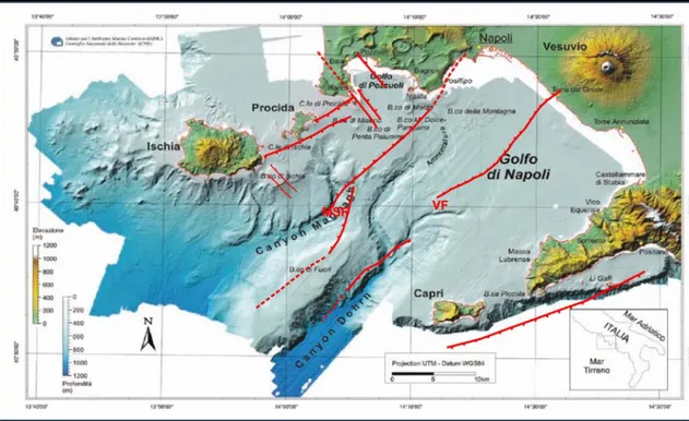
In the Bay of Naples a morphologic structure formed by a continental shelf, a continental slope and a basin can be singled out (Milia, 1999; Aiello et al., 2001) (fig. 5). The continental shelf has a width of about 20 km in the central area, decreasing towards SE, to 2.5 km near the island of Capri. In the Campi Flegrei offshore, the shelf is irregular, because of the presence of several banks whose morphologic characteristics suggests that they are volcanic edifices (Orsi et al., 1996). In particular, the CF sea floor is characterized by the presence of monogenic volcanoes, small calderas, tuff cones and lava extrusion (Milia, 1999). Most of them correspond to mound-shaped highs in the bathymetry. A structural high, formed by a horst of the carbonate basement (Banco di Fuori) is extended in a NE–SW direction in the central area of the bay, between Capri and Ischia Islands, with a minimum depth of 130 m (Fusi et al. 1991; Aiello et al. 2001). The maximum depth of the bay is about 1300 m, to the west of the island of Capri. The Naples Bay is dominated
Chapter 1 – Geological Setting
12
Fig. 5: Digital terrain model of the Naples Bay and adjacent areas (from D’Argenio et al., 2004). The map reported the main tectonic lineaments (taken from Bruno et al., 2003). VF: Vesuvius Fault; MSF: Magnaghi-Sebeto Fault.
by two submarine canyons: the Magnaghi and the Dohrn Canyons, both having a preferential NE–SW trend. The Magnaghi Canyon, about 15 km long and having a trilobate head, mainly drained the volcanoclastic input supplied by Ischia and Procida Islands during their eruptive activity. In contrast, Dohrn Canyon is about 25 km long and formed by two branches which merge into a main branch NW of Capri Island, draining the siliciclastic supply from the Sarno–Sebeto River plain (Dohrn south-eastern branch) and as well as volcanic material from the Campi Flegrei through the ‘‘Ammontatura’’ Channel (Dohrn north-western branch) (Secomandi et al., 2004).
Seismic reflection data from the Bay of Naples (Finetti and Morelli, 1974), recently reprocessed by Bruno et al. (2000, 2003) show faults cutting Pleistocene sediments with a prevailing NE–SW strike, except in the Neapolitan Yellow Tuff caldera, where NW–SE faults also occur (Fig. 5). In particular, a NE–SW normal fault, that seems to continue onshore (Bruno et al., 1998), was recognized in the Vesuvian area. This fault is the well-known Vesuvian Fault (fig. 5) (Finetti and Morelli, 1974; Bruno
13
et al., 1998, 2003) and could be considered one of the preferential pathways for Vesuvian magma. Many NE-SW faults and fractures are located between Ischia and Procida Islands, some of them correlating with some well-known volcanic banks (Bruno et al., 2003). A structural pattern composed of several NE–SW trending normal faults, imaged by seismic profiles and named the ‘‘Magnaghi–Sebeto’’ line (fig. 5) (Bruno et al., 2003) divides the Bay of Naples into two areas: a western area, characterized by several volcanic banks and reliefs and an eastern one, characterized by a NE-dipping monoclinal structure made of sedimentary rocks.
The two large caldera-forming eruptions were extensively studied at outcrops and deep bore holes (e.g. AGIP, 1987; Rosi & Sbrana, 1987; Scarpati et al., 1993; Orsi et al., 1996; Di Vito et al., 1999; Deino et al., 2004). Remnants of CI volcanic edifices/deposits can only be found at the very periphery of the Campi Flegrei area since they have been partially eroded and buried under younger deposits (Orsi et al., 1996). The NYT deposits are much better preserved and, for instance, Orsi et al., 1992, defined two main members corresponding to the main eruption phases and separated by a sharp unconformity. The NYT caldera collapse occurrence is marked by this unconformity. It was possible to make seismo-stratigraphic reconstructions of several units in the NYT deposits and younger (D’Argenio et al., 2004; Milia & Torrente, 2007), but not for the CI since acoustic penetration depth was insufficient.
The time span since ~ 15 ka until today is characterised by a three some millennium-long epochs of mostly subaerial volcanic activity restricted to the rim of the inner collapse area and interrupted by times of relative quiescence (Di Vito et al., 1999; Deino et al., 2004). Epoch I: 15 - 9 kyrs, explosive eruptions; Epoch II: 8.6 - 8.2 kyrs, explosive eruptions; Epoch III: 4.8 - 3.8 kyrs, explosive & rare effusive eruptions. The epochs' typical activity locations within CF are detailed given within Di Vito et al., 1999, as well. The last event was the Monte Nuovo eruption in 1538 A.D. west of the town of Pozzuoli after 100 yrs of uplift (Rosi & Sbrana, 1987; Bellucci et al., 2006).
Chapter 1 – Geological Setting
14
The interplay of long-term (eustatic sea level changes, continuous subsidence) and relatively short term (volcano-tectonic uplift) phenomena strongly influenced the evolution of Pozzuoli and Naples Bay in post-LGM times. Reconstruction of pre-LGM (Last Glacial Maximum) times is less defined because seismic resolution reached its limits at shallow depths due to strongly attenuating CI deposits (A. D’Argenio et al., 2004; Milia & Torrente, 2007). The Wurmian low sea level stand from ca. 18 to 14 ka B.P. of approx. minus 130 to 110 m (reference 0 m = today) generated level surfaces in the submerged part of the CF caldera and intense erosion along its subaerial morphologic rim (Orsi et al., 1996). During the Holocene, sea level rose rapidly by 9.5 mm/yr from 10 to 5.5 ka B.P. and approx. 1 mm/yr from 5.5 ka B.P. until today (after Fairbanks, 1989; Bard et al., 1990, in Milia & Giordano, 2002). For instance, D’Argenio et al., 2004, made a detailed seismo-stratigraphic and core data analysis of Naples Bay (similar did Milia et al. in numerous papers, 1998, 1999, 2000) and showed good correlation between the offshore intercalation of marine and reworked volcanic units and onshore volcanic deposits. Sediment supply acted as the leading force in the organization of stacking patterns of the seismo-stratigraphic units recognized in this area. Considerably but less detailed reconstruction was done in Pozzuoli Bay as very little sufficient acoustic data was or is available (e.g. Milia & Torrente, 2000). Mean sedimentation rates for the last 6 ka were 36 - 45 cm/ka in the central basin and 21 cm/ka at the outer shelf of Pozzuoli Bay (Buccheri & Di Stefano, 1984; in A. D’Argenio et al., 2004).
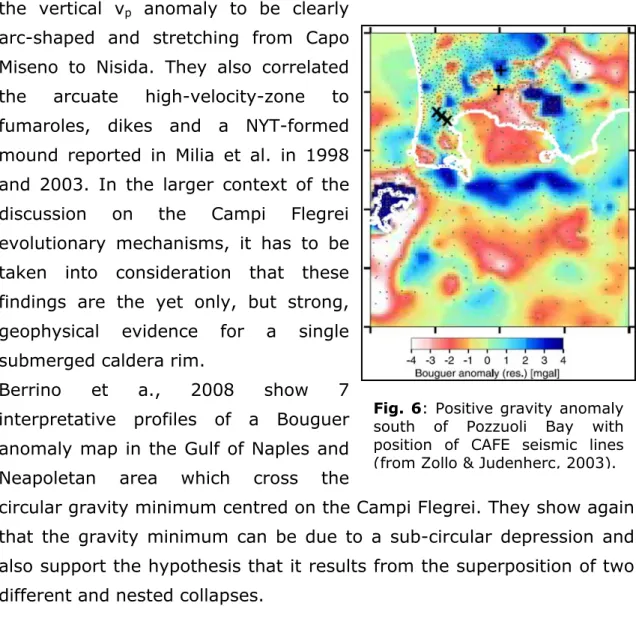
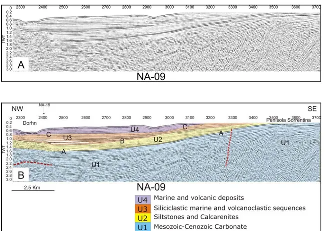
Zollo & Judenherc, 2003, found a buried feature resembling a quasi circular and single rim-like structure of 8 to 12 km in diameter at 0.8 to 2 km depth and with a height of 1 to 2 km just south of Pozzuoli Bay by active seismic tomography, fig. 6. The apparent rim is characterised by high p-wave velocity and high density rocks. Lithologic data from an experimental geothermal well drilled onshore by AGIP in 1986 (Mofete well, AGIP, 1987) pointed to consolidated lava and/or tuffs with high p-velocities of 3.5 - 4.5 km/s at the rim’s depth. A positive gravity anomaly of similar shape supports these findings (Capuano & Achauer, 2003). In a recent publication, Dello Iacono et al., 2008, further defined
15
the vertical vp anomaly to be clearly arc-shaped and stretching from Capo Miseno to Nisida. They also correlated the arcuate high-velocity-zone to fumaroles, dikes and a NYT-formed mound reported in Milia et al. in 1998 and 2003. In the larger context of the discussion on the Campi Flegrei evolutionary mechanisms, it has to be taken into consideration that these findings are the yet only, but strong, geophysical evidence for a single submerged caldera rim.
Berrino et a., 2008 show 7 interpretative profiles of a Bouguer anomaly map in the Gulf of Naples and Neapoletan area which cross the
circular gravity minimum centred on the Campi Flegrei. They show again that the gravity minimum can be due to a sub-circular depression and also support the hypothesis that it results from the superposition of two different and nested collapses.
Fig. 6: Positive gravity anomaly south of Pozzuoli Bay with position of CAFE seismic lines (from Zollo & Judenherc, 2003).
Chapter 1 – Geological Setting
16
1.2 Ischia Island
The island of Ischia is located on the westernmost portion of the CFVD (Orsi et al., 1996); the island is the emerged top of a large volcanic complex located along the NE–SW regional strain field (fig. 7).
Fig. 7: Topographic and bathymetric map of the Campi Flegrei-Ischia ridge. White lines are faults, black lines are ridges, red circles are crater rims, asterisks are latitebasaltic and latite volcanoes. (taken from Paoletti et al., 2009)
Bruno et al. (2002) hypothesize that Ischia represents only the remnant of a once larger volcanic complex and points out the importance of regional tectonics on the patterns of magma uprising. Acocella and Funiciello (1999) interpret the NE–SW lineaments as transfer faults with sub-vertical fault planes which could be easily intruded by magma. The Ischia offshore area is characterized by several monogenetic edifices, with latitebasaltic-latitic composition (Di Girolamo and Rolandi, 1975), aligned along the NE–SW system of faults that connects the South-Eastern sector of Ischia to the Island of Procida and to Campi Flegrei (Di Girolamo and Stanzione, 1973; de Alteris and Toscano, 2003). Part of
17
the island was invaded by marine waters prior and after the emplacement of the Green Tuff (GT), a major ignimbritic eruption dated at 55 ka (Gillot et al., 1982) that produced caldera collapse (Orsi et al., 1991; Tibaldi and Vezzoli, 1998).
After the GT eruption, the volcano-tectonic activity appeared to be mainly driven in the past 33 ka by the quasi-rigid uplift of Mt. Epomeo, interpreted as a resurgent block inside the caldera depression (Orsi et al., 1991). The island is characterized by a resurgent dome uplifted by at least 800 m (Gillot et al., 1982), displaying one of the largest resurgence cases ever reported. Two main models have been proposed to define the structure of the resurgent dome: 1) the volcanotectonic horst model, where the resurgent block is bordered by outward-dipping faults (Rittmann, 1944; Capaldi et al., 1976; Rittmann and Gottini, 1980; Vezzoli, 1988; Fusi et al., 1990; Luongo et al.,1995); 2) the simple-shear model, where the resurgent block, tilted around a N–S-trending horizontal axis, is bordered by high-angle inward-dipping faults (Orsi et al., 1991).
Fusi et al. (1990) and Tibaldi & Vezzoli (1998) proposed that the resurgent process of Ischia was produced by volumetric variations in the subsurface magma body. Orsi et al. (1991) suggest that the source mechanism is an increase in magmatic pressure in the upper part of a shallow magma chamber. Luongo et al. (1995) and Cubellis & Luongo (1998) used a punched laccolith mechanism to model the uplift of Mount Epomeo. Acocella et al. (1997, 1999) and Molin et al. (2003), according to similar experimental models, proposed that the resurgent doming of Mt. Epomeo is due to a trapdoor uplift mechanism, with a hinge in the south-eastern part of the island. More recently, Carlino et al. (2006) proposed that the uplift, the volcanic and seismic activity and the ground deformation of the past 2000 years are connected to the existence of a laccolith with a hypothesized diameter of 10 km and a depth of up to 1 km in the centre of the island.
Chapter 1 – Geological Setting
18
As regards this resurgent mechanism, the present seismic interpretation has allowed to propose a structural model of Ischia and its resurgent dome.
The present activity of Ischia is characterized by low-intensity and shallow seismicity, bradyseismic events and by hydrothermal activity (Maino and Tribalto, 1971; Rittman and Gottini, 1980; Buchner, 1986; Cubellis, 1985; Alessio et al., 1996).
19
CHAPTER 2
Seismic Stratigraphy Scheme
2.1 Methodology
During the seismic interpretation, the first step in building the stratigraphic framework is the identification of depositional units. Individual units were delineated on the basis of contact relations and internal layering characteristics as revealed by seismic reflectivity. The definition of packages into seismic sequences is obtained by means of reflector terminations and unit-internal feature classification. Seismic facies analysis allows to outline the environmental setting and to describe the lithofacies from seismic data. Seismic facies units are groups of seismic reflections whose parameters (configuration, amplitude, continuity, and frequency) differ from those of adjacent groups (Mitchum et al., 1977). Classical interpretative schemes (Emery and Myers 1996, Badley, 1985) were used to reconstruct faults kinematics; the shallow geological structures have been investigated taking into account the techniques of seismic stratigraphy, whose basic concepts are reported by Vail et al. (1991).
2.2 Seismo-stratigraphic features
CF region shows an extremely variable seismic response. Volcanic areas are often strongly heterogeneous. They present large vertical velocity variations due to their physical characteristics and to their peculiar sedimentation mechanism and to sin-depositional and post-depositional
Chapter 2 – Seismic Stratigraphy Scheme
20
chemical processes. In volcanic areas, stratigraphy is frequently complex because morphology, facies and elastic properties vary due to deposition and transport processes and paleotopography (Cas and Wright, 1987). Unlike for the well-known regularly widespread ‘‘pyroclastic fall’’ deposits, the above statement is particularly true for ‘‘pyroclastic density current deposits’’. These deposits are extremely variable sedimentological characteristics, and in both welding and zeolitization degree and therefore show extremely variable diagenetic facies. Welding variations primarily reflect variation of the emplacement temperature, whereas lithification due to zeolitization reflects post-depositional chemical alteration processes (Cole and Scarpati, 1993). A lateral transition between extreme facies occurs over distance as small as a few tens of metres (Bais et al., 2003). This complexity, reflected in the seismic sections, lead to an intrinsic difficulty in the interpretation of seismic data.
Seismic data acquired in the Campi Flegrei area (fig. 8) (Campi Flegeri-Ischia volcanic system) are characterized by low Signal/Noise ratio. The main reason of the signal decay is due to the massive presence of volcanic rocks and structures that produce a strong scattering of the seismic energy. While the western sector of CF is characterized by abundance of volcanic units, the eastern sector of CF is characterized by a NW-dipping monoclinal structure made of sedimentary rocks (high Signal/Noise ratio).
21
Fig. 8: Seismic data acquired in the Campi Flegrei area
2.2.1 Log data analysis
The geothermal wells “Trecase1”, drilled in the Somma-Vesuvius area, and “Licola1”, located in the southern zone of the shoreline Domitio (fig. 9) are used in order to carry out an indirect calibration of the age of the seismic sequences and in order to obtain geologic ties for constraining the interpretation of the seismic lines. Comparison between seismic sections and well log data, in fact, allows the association of lithotypes to variations in physical property of rocks and to relate each seismic sequences to a geologic unit.
Chapter 2 – Seismic Stratigraphy Scheme
22
Fig. 9: Stratigraphic columns of geothermal wells “Licola1” e “Trecase1”
The geothermal well “Trecase1” (fig. 9), located on land in the Somma-Vesuvius area (Balducci et al., 1985), is drilled for a total depth of 2068 m. Mesozoic-Cenozoic carbonate rocks were drilled at depths between 1670 and 1852 m b.s.l.. These carbonate rocks are overlain by conglomerates deposited in a subaerial environment (Milia et al., 2003) during a period of emersion of the area that is also witnessed by the absence of Pliocene marine sediments on- and off-shore (Brancaccio et al., 1991; Milia, 1999b). The subaerial conglomerates are overlain by 0.98–1.24 Ma-old marine siltstones and calcarenites (Milia et al., 2003). The Lower Pleistocene siltstones and calcarenites are overlain by deep marine clays deposited when Naples Bay reached the maximum water depth. The deep marine clays are overlain by 400 ka-old lavas followed by a succession of marine to subaerial sandstones and siltstones with
23
interbedded lavas and tuffites and stratified sands. The latter unit was deposited between 400 and 100 ka in Naples Bay (Milia, 1999a), during tectonic stability and fills the central part of the basin. The latest products (0-252 m), late Quaternary in age, are made up mainly of pyroclastic deposits of the Campanian Ignimbrite (39 ka-old; De Vivo et al., 2001).
“Licola 1” well, located outside CF caldera, is deep 2653 m. Log recording starts at 235 m depth: the stratigraphy is characterized for the first 1500 m by tuffs of different nature erupted from Campi Flegri Volcanic District and Somma-Vesuvius; the interval comprised between 1550 m and 2000 m is characterized by a level of silt and clay. Below 1900 m and down to the bottom of the well, the contemporary presence of levels of lava, tuffs and sandstone may indicate the early stage of CF volcanism, with prevailing submarine activity (Bruno, 2004).
2.2.2 Seismic data analysis
The lack of deep geothermal wells in the CF offshore area makes the reconstruction of the age of basin formation and the chronological calibration of seismic sequences filling more complex. The interpretation of the seismic profiles permitted to identify four main seismic units (ages are inferred by well Trecase 1) (Table 1).
From top to bottom, the defined seismic sequences are delimited by three seismic horizons, representing geological unconformities, which may be correlated with the structural stratigraphic units of the southern Apennines:
Unconformity C: top of seismic unit U3. It may represent a marine
flooding surface.
Unconformity B: top of seismic unit U2. It is characterized by high
amplitude and complex morphology. It represents a clear angular unconformity.
Chapter 2 – Seismic Stratigraphy Scheme
24
Unconformity A: Top of the tilted Meso-Cenozoic carbonates (seismic
unit U1), cropping out in the Sorrento Peninsula and Capri Island.
Legend Seismic facies Description Origin Age
U4 Transparent; continuous, high amplitude, parallel reflections. Highest unit, widely present at bottom of all the Gulf of Naples. The unit onlap onto seismic reflector “C”.
Marine deposits that coexist with volcanic and volcanoclastic sequences erupted from CF and Somma-Vesuvius. Late Quaternary U3 Variable energy; clinoform continuous and with high amplitude; transparent facies. Sedimentary unit (prograding wedge). Siliciclastic marine successions and volcanoclastic sequences Middle Pleistocene U2 Oblique-parallel reflections with high amplitude and continuity First sedimentary unit in the basin; prograding wedge dipping to the NW. Siliciclastic marine successions (cyclic depositional consisting of alterning sands and clay), involved in tectonic tilting with carbonates Lower Pleistocene
U1 Chaotic Seismic basement
of sedimentary basins; monoclinal reflectors dipping to the NW Carbonates, cropping out in the Sorrento Peninsula and in the Capri Island.
Meso-Cenozoic
Tab. 1: Unit of Campi Flegrei offshore area
In figure 10, the correlation between Trecase well litostratigraphy and the seismic units recognized, is reported.
25
Fig. 10: Carbonate rocks (unit U1) form the substrate of the basin fill. Unit U2 correspond to the oldest marine sediments overlying the substratum. It probably was deposited during an early event of tectonic subsidence, controlled by the activity of NW-SE extensional faults, responsible for the change from subaerial to marine environment. Unit U3 was deposited during tectonic stability and fills the central part of the basin. The latest depositional sequence, Unit U4, consists of pyroclastic deposits which coexist with marine sediments deposited during a period of low sea level.
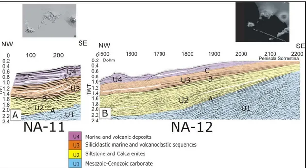
In figure 11 part of the seismic line Na-11 and Na-12 are reported. These lines represent an example of how the previously described depositional units were identified. The three main unconformities (labelled A, B, C) are clearly recognized. Seismic unit U4 is the highest unit with parallel and narrow spaced reflectors (marine deposits) (fig 11-A), onlapping above unconformity C. The unit U3 constitutes a sequence of variable seismic facies energy, mostly continuous and with sub-parallel reflectors (fig 11-B); this facies is characterized also by prograding clinoforms (fig. 11-A). The seismic unit U2 is characterized by reflections with high amplitude and continuity (fig 11-A). In the Bay of Naples unit U2 constitutes a prograding wedge dipping NE (fig 11-B).
Chapter 2 – Seismic Stratigraphy Scheme
26
Seismic unit U1 is the seismic basement cropping out in the Sorrento Peninsula (fig. 11-B). Within this unit, areas with low reflectivity alternate with strong and very discontinuous reflectors (fig. 11-A).
300
Fig. 11: Part of seismic line Na-11 (A) and Na-12 (B).
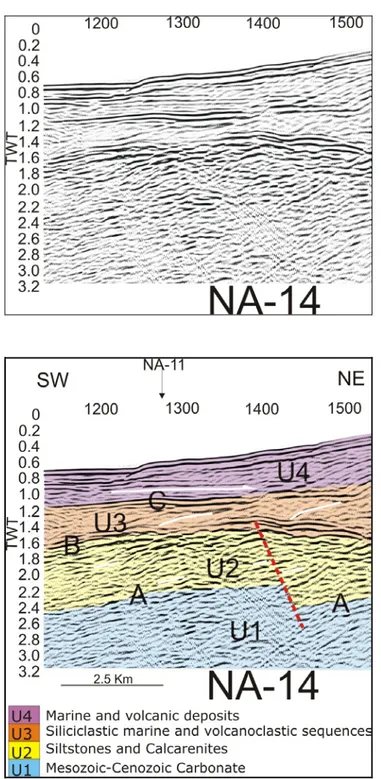
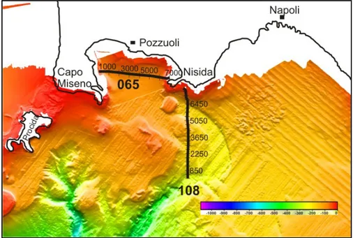
As for another example to recognize the seismic units, I show part of the seismic profile Na-14 (CDP 1140-1520) and the corresponding interpretation (fig. 12). The seismic unit U4 is onlap above C; the seismic unit U3 is characterized by clinoforms and acoustically transparent facies. Unconformity B is characterized by high amplitude reflections and complex morphology; it represents, in fact, an important tectonically-enhanced unconformity; the reflector of seismic unit U2 appears contorted and discontinuous: probably the deposition of this sequence has happened during the of the Plio-Pleistocene tectonic-volcanic activity. The seismic unit U1 is characterized by lack of stratifications.
In some seismic profile (es: Na-08, Na-09, Na-12), it was possible to make a clear distinction between the Holocene marine deposits and the
27
volcanic and volcanoclastic sequences erupted from CF and Somma-Vesuvius.
Fig. 12: Seismic profile Na-14 and corresponding interpretation. (for location of the seismic line, see fig. 8)
Chapter 2 – Seismic Stratigraphy Scheme
28
The high-resolution seismic profiles acquired in the offshore area south of the Campi Flegrei (i.e. Pozzuoli Bay) (fig. 13) permitted to perform a detailed seismo-stratigraphic analysis of Pozzuoli Bay.
Fig. 13: High-resolution seismic profiles acquired in the offshore area south of the Campi Flegrei (Pozzuoli Bay)
Four major seismic units (fig. 14) are defined by picking their top reflections. In particular seismic profile GeoB08-065 (fig. 48)
Fig. 14: Multichannel seismic profile in Pozzuoli bay showing units: G1, G2, G3 and V.
29
permitted to define the seismic units. These four seismic seismo-stratigraphic units are delimited by three principal seismic horizons (labelled D, E, F).
Unit G1 (< 4 ka B.P): From a descriptive point of view, unit G1 is assumed to start with the first reflection below the seafloor: highest unit, widely present at bottom of all the Gulf of Pozzuoli. The top and internal reflections are wavy to hummocky and subparallel with a medium to high amplitude and good lateral continuity. The thickness of the unit generally increase with distance to the coast. Unit G1 is presumably bounded by a seismic unconformity at its base as sporadic onlap reflections indicate (line 065, CDP 1000).
According to Milia et al., 2002, the uppermost unit (unit G1) is made up of three subunits.
- Unit G1x characterized by undisturbed high amplitude and good continuity reflectors which onlap above horizon F (fig. 15).
- Unit G1y: the bending of horizon F may be caused by an emplacement of a magmatic intrusion. The clear
onlap terminations of unit G1y above horizon F suggest a very recent deformation (fig. 16).
- Unit G1z (CDP 6000-7000) constitutes a complex prograding unit (fig. 17). The seismic facies is characterized by low-amplitude and good moderate continuity of the reflectors. The stratigraphic position of unit G1z suggest that it represents the highstand record of the sea level
Fig. 16: seismic profile GeoB08-065 showing unit G1y
Fig. 15: seismic profile GeoB08-065 showing unit G1x
Chapter 2 – Seismic Stratigraphy Scheme
30
Unit G2 (8.2 - 4 ka BP): This unit can be split into two parts:
G2x) has very weak amplitudes (partly transparent) throughout its traceability along all profiles (partly transparent);
G2y) internal reflections of this unit are of very high amplitude, parallel and continuous and good lateral continuity.
This unit is constituted by marine sediments, concordantly overlying each other
Unit G3 (11-8.6 ka BP): Unit G3 is characterised by a wavy top reflection, which is highly disrupted, covering a band of reflections of high to mid amplitude with parallel to subparallel and, at some parts, disturbed reflection patterns. It is, in general, build up by disturbed to chaotic reflections of mid to predominantly low amplitude. The zone’s reflection amplitude is very high in the upper but decreases rapidly to transparency with depth.
Unit G3 is related to thick marine units due to first strong subsidence, creating large accomodation space at inner N of Pozzuoli Bay
Unit V: The top of unit V is wavy continuous and of low amplitude. The base of Unit V could not be traced thus no thickness was derived for it. The deeper parts of unit V are always masked by multiple reflections or by transparency. At the top, Unit V is limited by a rough erosional surface that exhibits subaerial character. This unit is related to the Neapolitan Yellow Tuff erupted from Campi Flegrei 12000 years ago (Milia et al., 1998). Unit NYT is the offshore continuation of that unit cropping out in Bagnoli and Posillipo.
The wedge-shaped Unit V2 could be interpreted as a distinct depositional unit of the Neapolitan Yellow Tuff (NYT) (Cole et al., 1993).
Fig. 17: seismic profile GeoB08-065 showing unit G1z
31
The stratigraphic analysis of deep boreholes, which are located in the city of Naples, in fact, indicates that the NYT pyroclastic deposits are characterised by the superposition of two distinct units (Scarpati et al., 1993): the lower subunit is a phreato-plinian ashfall follwed by pyroclastic surges, representing the initial eruptive phase. The upper subunit is made of numerous pyrocalstic flows which show up as thick and massive units with internal layering (Perrotta & Scarpati, 2002). In general, the acoustic substrate in the Pozzuoli bay central plain comprises a chaotic seismic facies attributed to the Neapolitan Yellow Tuff (12.0 ka B.P.) and which is overlain by three sedimentary units: G1, G2, and G3 (Milia-Giordano, 2002). Unit G1 and Unit G2 are marine Holocene sediment that drapes all pre-existing morphology; unit G3 should be a thick marine units due to strong subsidence, creating large accomodation space at inner N of Pozzuoli Bay. Units G2 and G3 correspond to the marine succession outcropping at La Starza (12.0–4.0 ka B.P.), whereas unit G1 has been dated to less than 4.0 ka B.P (Cinque et al., 1985).
Chapter 3 - Interpretation of seismic reflection profiles offshore Campi Flegrei
32
CHAPTER 3
Interpretation of seismic reflection profiles offshore Campi
Flegrei
3.1 Introduction
Campi Flegrei (CF) region is one of the most hazardous volcanic and seismic areas in the world, therefore the geophysical study of its marine environment (where little direct information are available) is a key to better understand this area. The data used in this chapter are recently reprocessed by Bruno et al. (2002, 2003). The main goal was to build the stratigraphic framework through the identification of depositional units and to delineate a broad geo-volcanological and structural framework of the CF with the aim of exploring the connection between volcanism and tectonics. Individual units were delineated on the basis of contact relation and internal layering characteristics as revealed by seismic reflectivity. Seismic facies analysis permits to delineate the environmental setting of the studied area. The identification on seismic section of important faults allows to perform a structural analysis of the CF area. The study stresses also on the recognition of the fault systems responsible for the formation of Ischia Island and the Bay of Naples and finding their relationship with the sedimentary and volcanic units of the area. The original seismic dataset was characterized by low redundancy and low bandwidth; reprocessing yielded an improvement of the seismic dataset quality by means the most recent techniques aimed to the enhancement of signal to noise ratio. A comparison between the new and old data (Bruno, 2002) shows that the new sections are characterized by a much higher S/N ratio; this permitted to gain new constrain on the structural setting of CF offshore area. Because of the
33
structural complexity of the studied area, all the available geological and geophysical data were utilized to aid interpretation such as exploratory wells located few kilometres off the seismic profiles and the high resolution magnetic anomaly map of the gulf (Siniscalchi et al., 2002; Aiello et al., 2004). The previous seismic studies at the same scale in adjacent areas (Bruno et al., 1998; Bruno et al., 2000; Bruno et al., 2003; Bruno 2004) was a fundamental tool for interpretation. The identification on seismic section of important faults allows to perform a structural analysis of the CF offshore area and to estimate their kinematics.
Chapter 3 - Interpretation of seismic reflection profiles offshore Campi Flegrei
34
3.2 Interpretation of the seismic lines
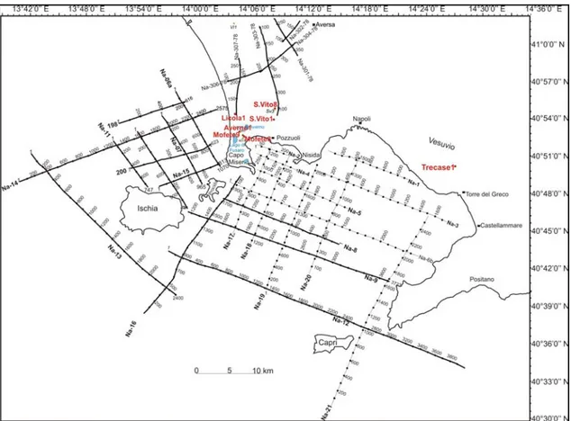
The interpretation concerns 13 seismic lines (fig. 19), covering an area of about 2000 Km² which extends from the northern coast of Ischia and Procida Island up Sorrento Peninsula. These seismic lines have a NW-SE and NE-SW prevalent direction but the structural style of the area is best underlined on NW-SE lines (lines Na-08, Na-09, Na-12, Na-13). We will proceed the description beginning from the oldest southern-eastern portion of the area. Lines Na-09, Na-08 and Na-12 permitted, in fact, to delineate the geological setting of the eastern sector of the Bay of Naples.
Seismic line Na-09 (fig. 20) best outlines the tectonic relationships between Bay of Naples and Campi Flegrei-Ischia Ridge.
35
Fig. 20: Seismic line Na-09 (A) and interpretation (B). The greater tectonic complexity of Campi Flegrei area with respect Vesuvius district (Bruno et al., 2000; Piochi et al., 2005) is visible. In
Chapter 3 - Interpretation of seismic reflection profiles offshore Campi Flegrei
36
The seismic line (fig. 20) shows a seismic response extremely varied. In the left part (to the NW of Canyon Magnaghi) an area with a low Signal/Noise ratio is present, then the line runs in an area characterized by good reflectivity (Gulf of Naples). The line, in fact, crosses in its first part (CDP 0-1700) the area characterized by the maximum deformation rate related to the opening the Tyrrhenian Sea. Seismic line Na-09 (CDP 2300-3700) (fig. 21), shows that in the Bay of Naples, the horizons A and B assume a NW-dipping monoclinal trend. As already identified by Finetti and Morelli (1974) and Fusi (1991), the tilted Mesozoic carbonates crop out in the Sorrento Peninsula. The eastern area of the bay is made, in fact, of sedimentary rocks; the reflectors that characterize this part of the section do not show particularly interpretation problems; all the reflectors are characterized by good energy. Units 2 in this area exhibits features typical of a basin fill sequence, with onlap on both sides of unconformity A. Units U3 and U4 (CDP 2400-3500) (fig. 21) permit also to distinguish a proximal to distal seismic facies variability. The facies succession of these seismic units consists of basal convergent onlapping packages overlain by chaotic zones. Onlap and draping facies are best developed in the distal portion of the basin and are frequently removed in the proximal portion of the basin. The seismic section moreover shows (CDP 2300-2400 – TWT 1.3-1.6 s) that the monoclinal trend of the unconformity A and B is abruptly interrupted beneath the Dhorn Canyon. The monoclinal trend that characterizes the unconformities (CDP 2500-3000) (fig. 21) is, in fact, interrupted by a dome-like structure (CDP 2300-2400); the seismic units U2 and U3 passes from a seismic facies characterized by continuous and parallel reflectors to a chaotic and contorted configuration. Such deformation could be caused by the presence of a magmatic intrusion. The onlap terminations of the reflectors of the seismic unit U3 above B (CDP 2400 – TWT 1.2), permit to date as late-Pleistocene the onset of the deformation.
37
Fig. 21: Part of the seismic line Na-09 (A) (CDP 2300-3700) and corresponding interpretation (B). The monoclinal trend is interrupted by a dome-like structure.
Line Na-09 in correspondence of CDP 1830-2030 (fig. 22), in the median zone between the Dohrn and Magnaghi canyons, crosses a structural high. The line probably crosses a volcanic bank which represents a relic morphology, characterized from the outcrop to the deep sea of erosional surfaces. In correspondence of CDP 1500-1700 (fig. 22), the reflectors of the units U3 and U4 evidence the passage from an oblique configuration to a sub-parallel ones. In this sector (CDP 1400-1800), in fact, the line crosses the continental slope of the Ischia Island. The sigmoidal-oblique progradation pattern configuration, showing a package of sediments characterized by a high-frequency seismic facies, probably is originated from the dismantling of Ischia volcano slopes.
Chapter 3 - Interpretation of seismic reflection profiles offshore Campi Flegrei
38
Fig. 22: Part of the seismic line Na-09 (A) (CDP 1400-2000) and interpretation (B). In correspondence of CDP 1600, reflectors of U2 and U3 passes from an oblique configuration to a sub-parallel ones.
In the western sector of the Bay of Naples, seismic line Na-09 shows that the monocline structure of the carbonate basement in the Gulf of Naples, is interrupted by a fault system, with large throw, which isolate a horst-like structure beneath Ischia (fig. 23 - CDP 900-1400). Two inverse faults (CDP 800 and CDP 1440) are recognized in the seismic section. The line between CDP 800-1800 (fig. 23), near Ischia Island eastern cost, exhibits, within seismic units U3 and U4, lateral outward
39
progradation (CDP 1500 – 1800). The prevailing structure revealed by downlapping geometry is accompanied by an outward thickening of these seismic units. Seismic unit U4 also shows similar, although reduced, pattern of outward progradation.
Chapter 3 - Interpretation of seismic reflection profiles offshore Campi Flegrei
40
Seismic line Na-12 (fig. 24) runs between the Gulfs of Naples and Salerno, between the Island of Capri and the Sorrentina Peninsula. The seismic unit U2 (CDP 1500-2100) is characterized by reflectors tilted towards NW with oblique-parallels configurations and in paraconcordance over of the meso-cenozoic acoustic basement (seismic unit U1). Unit U2 could be interpreted like a prograding wedge of lower Pleistocene age (see tab. 1 – chapter 2 – para. 2.2.2), formed by clastic sediments (cyclic depositional consisting of alterning sands and clay). In the Bay of Naples the basement (seismic unit U1) shows a regular dip towards NW with the exception of the presence of the structural high of “Banco di Fuori” (CDP 1000-1450) that interrupts the monoclinal trend of the structures (Fusi 1991, Aiello 2005). This morphostructural high, situated between Dohrn and Magnaghi canyons, and elongated in NE-SW direction, with the south-eastern flank steeper than the north-western one, presumably is formed by a tilted block of Mesozoic carbonates (Aiello et al., 2005). Moreover, seismic line Na-12 shows that the monocline trend is dissected by normal faults (CDP 2800-3100). These structures, with a regional relevance, causes the abrupt sinking of the carbonatic basement south of Sorrento Peninsula and separate the Gulf of Naples from the Gulf of Salerno, which completely lack of volcanism.
Line Na-08 (fig. 25), which runs from the western branch of Dohrn canyon up to the eastern offshore of Ischia Island, puts well in evidence that in the uppermost seismic unit (U4), the reflectors appear contorted and discontinuous (CPD 800-1600), with diffuse presence of dome-like structures; the same seismic unit between CDP 0-800 is characterized by parallel reflectors with high amplitude and continuity. The profile in correspondence of CDP 700, TWT 1.6 sec, shows that the monoclinal trend of unconformity A is interrupted. Line Na-08 allows, in fact, to detect the deformed basement (seismic unit U1): the U1 reflectors appear chaotic between CDP 800-1600 whereas show good continuity between CDP 0-800.
41 Fig. 24: Seismic profile Na-12 (A) and corresponding interpretation (B).
Chapter 3 - Interpretation of seismic reflection profiles offshore Campi Flegrei
42
Fig. 25: Seismic profile Na-08 (A) and corresponding interpretation (B).
Moving in the north-west sector of the study area, a number of lens-shaped structure and morphological depression with an aspect caldera-like, are recognized. The first structures, well evident on the lines Na-06 (fig. 26) and on the Na-11 (fig. 27), showing a complex internal morphology and limited by significant contrast in acoustic properties (velocity and density), are interpretated as related to shallow, sill-like magmatic structures on the base of their geometry, seismic signal and
43
structural relationship with the sedimentary host-rock. The morphological depressions, recognized on line Na-15 (fig. 28), are interpreted as related to caldera collapses with thick accumulation of proximal pyroclastic deposits.
Seismic line Na-06 (fig. 26) with NW-SE trend, localized to N of Ischia, puts in evidence (CDP 280-400; TWT 1.4 s) the presence of a lens-shaped structure delimited at the top and at the base by strong seismic reflections. It is interpreted as a magmatic sill, which intruded into the seismic unit U3.
Seismic profile Na-11 (fig. 27), located in the northern offshore of Ischia Island, with a NW-SE trending, shows unit U4 in onlap above C; seismic unit U3 is characterized by clinoform with eroded topset and sub-parallels reflectors (probably placed at the end of the subsidence phase that interested carbonatic platform), unconformity B appears deformed. Within seismic unit U2, reflectors, generally undisturbed outside this area, appear discontinuous, even within the most recent units. These configurations may indicate diffuse presence of volcanic features. Chaotic to contorted reflectors within unit U1 can be interpreted as expression of the deformed carbonate basement. In the centre of profile Na-11 (fig. 27) (CDP 300-400 - TWT 1.4 sec.) the existence of a lens-shaped feature within seismic unit U2, easily distinguished from surrounding stratal reflections, could be tied to the presence of another magmatic sill. On the right side of section Na-11 (fig. 27) (CDP 450-700), the seismic unit U3 consists of a sequence of continuous and sub-parallels reflectors characterized by a progradational configuration.
Chapter 3 - Interpretation of seismic reflection profiles offshore Campi Flegrei
44
Fig. 26: Na-06 seismic line (A) and interpretation (B). The profile, with NW-SE trending, localized to N of Ischia shows the presence of a magmatic sill.
45
Chapter 3 - Interpretation of seismic reflection profiles offshore Campi Flegrei
46
Seismic profile Na-15 (fig. 28) runs from Ischia to the Campi Flegrei. On the right side (CDP 500-800), reflectors of seismic unit U4 show a progradational configuration onlapping above C. The sedimentary supply comes from northeast and could be directly connected to the volcanic activity of the Campi Flegrei. The reflectors indicate a high rate of accommodation during the emplacement of the volcano-clastic deposits. In the north-east sector of Ischia Island, where the seismic unit U3 reaches the maximum thickness (1,3 s TWT, approximately 2000 m), seismic line Na-15 evidences a morphological depression. This last structure, with an aspect caldera-like, situated less than two kilometres from the coastline, could be genetically connected to eruption of Campanian Ignimbrite.
The western sector of the Ischia Island offshore is shown by seismic line Na-13 (fig. 29). The line, between CDP 1000-1350, shows that seismic units U1, U2, U3 and U4 were involved in an uplift process. It is possible to differentiate (CDP 900-1400) an external block, delimited1 by high angle reverse faults, and an inner block, delimited by normal faults. The source mechanism may be a magmatic intrusion (as a laccolith) located at a depth of approximately 3 Km. The small thickness of the seismic unit U3 (CDP 1100-1300) in this zone is probably caused by erosion processes. The highest unit (U4) is characterized by parallel reflector with good continuity and high amplitude. Between CDP 700-1000, seismic unit U3, to the NW of Ischia resurgence, shows a progradational configuration. Between CDP 1800-2400 a dome-like structure is present; the faults associated to such structure cut also the uppermost Late Quaternary reflectors. This structure could be tied to an other volcanic block reviving to SE of Ischia. The geometry of the folded strata, characterized by constant thickness, suggests a post-depositional and very recent folding. In CF offshore area, in fact, are common (Milia and Torrente, 2000) magmatic intrusion which rose upward and caused the warping of the overlying horizontal layers.
47
Fig. 28: Seismic profile Na-15 (A) and interpretation (B). It is possible to note a volcanic related sinking (CDP 600-800). The U4 reflectors show a progradational configuration: sediment supply may be related to the volcanic activity.
Chapter 3 - Interpretation of seismic reflection profiles offshore Campi Flegrei
48
49 -Line Na-13 (fig. 29), in correspondence of CDP 2200 – TWT 2.2 s., shows the presence of a reflection free zone interpreted a magmatic sill, whose presence is also visible on seismic line Na-16 (fig. 30) that crosses Na-13 in correspondence of CDP 2250.
Interpretation of transverse seismic reflection profile -seismic line 198 (fig. 31) - from North to Ischia to the Campi Flegrei, puts in
evidence a system of normal faults that underline the substantial deepening of the Mesozoic carbonatic acoustic basement towards north-east (Campi Flegrei); the carbonate sinking (seismic unit U1) in CF area is evidenced also by the geothermal wells Licola1 and Trecase 1 (fig. 9). Licola1, located outside the CF caldera, on the shoreline, not drilled the limestone until the bottom of the well (2655 m); instead Trecase1 recovered the acoustic basement to the depth of 1885 m. Seismic Unit U1 was affected by strong continuous subsidence as a consequence of extensional tectonic which affected the inner part of the Apenninic chain, after the end of the Mio-Pliocene piling-up of Apenninic chain. The litostratigrafic data of Licola1 and Trecase1 well indicate a high subsidence rate of the Campanian Plain in the last 1 Ma.
Fig. 30: Seismic profile Na-16 shows a magmatic sill (CDP 150-500 - TWT 2 sec).
Chapter 3 - Interpretation of seismic reflection profiles offshore Campi Flegrei
50
51
-3.3 Discussion
Seismic line Na-09 provides an overview of the structural setting of the Bay of Naples. Seismic reflection data permitted to split the whole territory of the study into three different sub-areas. Starting from Bay of Naples eastern sector and running in NW direction, it is possible to differentiate (fig. 32):
1) The eastern sector characterized by the NW-dipping Meso-Cenozoic substrate cropping out in the Sorrento Peninsula and in the Capri Island.
2) The northern area of the bay, the Campi Flegrei offshore, characterized by the presence of volcanic banks and dominated by two submarine canyons;
3) The uplift observable around the Island of Ischia.
3.3.1 Evolution of the Bay of Naples
The geological evolution of the Campania continental margin, following the geodynamic evolution of the Neogene Southern Apennines– Tyrrhenian Sea system, included two orthogonal extensional phases: an older one, linked to NW–SE faults that produced horst and graben structures parallel to the Apenninic chain, was followed by the main extensional event that gave rise to asymmetric extensional structures controlling the physiography of the region. The Bay of Naples is one of these NE-trending half grabens with its depocenter located in the north-west. Two NE–SW trending ridges bound the Bay of Naples: to the north, the Campi Flegrei consists of about 50-km-long active NE–SW volcanic ridge; another ENE–WSW trending ridge, the Sorrento Peninsula, bounds the Bay of Naples to the S. As a result, the basin fill architecture of the Bay of Naples is characterised by a NW-dipping Meso-Cenozoic substrate (seismic Unit U1 – see tab. 1, chapter 2, para. 2.2.2), overlain by an angular unconformity attributed to the Pliocene–
Chapter 3 - Interpretation of seismic reflection profiles offshore Campi Flegrei
52
-Pleistocene emersion of the area (Milia and Torrente, 1999; 1997), and covered by a Quaternary succession of stratified sediments. The Quaternary deposits have been previously reported (tab.1; chapter 2; para. 2.2.2). The first products of volcanism were emplaced 400 ka ago, at the end of the main extensional phase, when the crustal thinning of the Campania continental margin made the lower crust more susceptible to melting and flow (e.g. Hendrie et al., 1994; Hay et al., 1996).
The shelf bordering the NW coast is instead part of an extensive system of volcanic banks formed before the last Wurmian regression (18–14 ka; Pescatore et al., 1984). A structural high formed by a horst of the carbonate basement (Banco di Fuori) is extended in a NE-SW direction in the central area of the bay, between the Capri and Ischia Islands, with a minimum depth of 130 m (Milia, 1999; Aiello et al., 2001). Two canyons engrave the continental slope: the Magnaghi Canyon, located between Ischia and Bocca Grande bank, and the Dohrn Canyon, positioned between Banco di Fuori and Capri (Aiello et al., 2001).
Reflection profiles have shown a structural pattern of normal faults cutting Pleistocene sediments with a prevailing NE-SW strike. This trend is named the Magnaghi-Sebeto line (Bruno et al., 2003) and divides the Bay of Naples into two areas: a western area, characterized by several volcanic banks, and an eastern one, characterized by a NW-dipping monoclinal structure made of sedimentary rocks.
This work is mainly focus on the Ischia structure as detailed description of the eastern part of the Bay of Naples have been done by previous authors (Finetti et al., 1974, Bartole et al., 1984; Bruno et al., 2000; Bruno et al., 2003; Bruno 2004, Aiello et al., 2004; Milia and Torrente, 1997; 1999).
53